


![]()

zprávy
zdroje zpráv:Seventh Sentinel satellite launched for Copernicus
25.4.2018 21:32 ESA Observing the Earth
The second Sentinel-3 satellite, Copernicus Sentinel-3B, was launched today, joining its identical twin Sentinel-3A in orbit. This pairing of satellites increases coverage and data delivery for the European Union’s Copernicus environment programme.
Liftoff replay
25.4.2018 20:10 ESA Observing the Earth
Watch the replay of the Sentinel-3B liftoff from the Plesetsk Cosmodrome in northern Russia
Sentinel-3B liftoff
25.4.2018 19:57 ESA Observing the Earth
Sentinel-3B lifted off on a Rockot launcher from the Plesetsk Cosmodrome in northern Russia at 17:57 GMT (19:57 CEST)
Sentinel-3B liftoff
25.4.2018 19:57 ESA Observing the Earth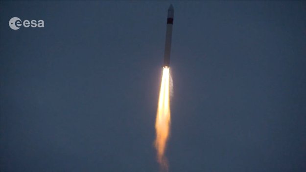
Sentinel-3B lifted off on a Rockot launcher from the Plesetsk Cosmodrome in northern Russia at 17:57 GMT (19:57 CEST)
Ještě se můžete přihlásit do bezplatného šestitýdenního online kurzu kartografie
25.4.2018 17:26 GeoBusiness Ještě se můžete přihlásit. Bezplatný šestitýdenní online kurz kartografie od školitelů Esri sice už začal, ale až do začátku května se opozdilci mohou přihlašovat. ... PřečístMzdová účtárna
25.4.2018 15:52 ČÚZK - volná místa Český úřad zeměměřický a katastrální vypisuje výběrové řízení na místo Mzdová účtárnaMzdová účtárna
25.4.2018 15:52 ČÚZK - předpisy a opatření Český úřad zeměměřický a katastrálnívypisuje výběrové řízení na místo
Mzdová účtárna
Mzdová účtárna
25.4.2018 15:52 ČÚZK /Urady/Cesky-urad-zememericky-a-katastralni/Uredni-deska/Oznameni-a-jina-uredni-sdeleni/Volna-mista/Mzdova-uctarnaTeledyne Optech’s Dr. Paul LaRocque to deliver keynote address at ISPRS TC III Symposium
25.4.2018 15:27 GISCafe.com Webcasts-Webinars April 25, 2018 — Teledyne Optech is pleased to announce that Dr. Paul E. LaRocque, VP Special Projects, will be presenting a keynote address at …US Geological Survey Selects Hexagon to Upgrade Machine Learning Tool
25.4.2018 15:27 GISCafe.com Webcasts-Webinars HUNTSVILLE, Ala., April 25, 2018 (GLOBE NEWSWIRE) -- The US Geological Survey (USGS) has selected Hexagon US Federal to upgrade the machine …First Unmanned Aircraft System (UAS) and Automated Guided Vehicle (AGV) Certified by UL
25.4.2018 15:26 GISCafe.com Webcasts-Webinars NORTHBROOK, Ill., April 25, 2018 — (PRNewswire) — Unmanned or automated electric vehicles and systems are now available with UL …Registration Now Open for Trimble Dimensions 2018 User Conference
25.4.2018 14:33 GISCafe.com Webcasts-Webinars Three-Day, Action-Packed Conference for Trimble Users to Learn, Collaborate and Network with PeersSUNNYVALE, Calif., April 25, 2018 — …
20180425 - Problémy s přenosem změn do RÚIAN/VDP
25.4.2018 14:24 ČÚZK /Uvod/Produkty-a-sluzby/RUIAN/RUIAN-novinky/2018/20180425-Problemy-s-prenosem-zmen-do-RUIAN-VDP20180425 - Problémy s přenosem změn do RÚIAN/VDP
25.4.2018 14:24 ČÚZK - předpisy a opatření Důležité sdělení:V pondělí 23. 4. 2018 došlo k zablokování komunikační fronty z ISÚI do RÚIAN. Intenzivně pracujeme na odstranění technických problémů, jejich vyřešení předpokládáme v průběhu čtvrtka 26. 4. 2018. V důsledku zablokované fronty nedochází k přenosu změn z ISÚI do RÚIAN/VDP. Omlouváme se za případné komplikace.
20180425 - Problémy s přenosem změn do RÚIAN/VDP
25.4.2018 14:24 ČÚZK - předpisy a opatření Důležité sdělení:V pondělí 23. 4. 2018 došlo k zablokování komunikační fronty z ISÚI do RÚIAN. Intenzivně pracujeme na odstranění technických problémů, jejich vyřešení předpokládáme v průběhu pátku 27. 4. 2018. V důsledku zablokované fronty nedochází k přenosu změn z ISÚI do RÚIAN/VDP. Omlouváme se za případné komplikace.
Nedostupnost evidence ÚPD
25.4.2018 12:30 Jihočeský kraj Kvůli technickým problémům je dočasně nedostupná evidence územně plánovací dokumentace. Na opravě se pracuje. Mapová aplikace nicméně běží i nadále. Děkujeme za pochopení.Nedostupnost evidence ÚPD
25.4.2018 12:30 Jihočeský kraj Kvůli technickým problémům je dočasně nedostupná evidence územně plánovací dokumentace. Na opravě se pracuje. Mapová aplikace nicméně běží i nadále zde. Děkujeme za pochopení.Prezident Mezinárodní kartografické asociace bude přednášet v Olomouci
25.4.2018 11:43 GeoBusiness V Olomouci se v následujících dnech bude konat čtyřdenní mezinárodní kartografický pracovní seminář. Workshop společně pořádají tři odborné komise Mezinárodní kartografické asociace ICA, konkrétně ... PřečístRočenka realitního trhu pro rok 2018
25.4.2018 10:52 GeoBusiness Asociace pro rozvoj trhu nemovitostí (ARTN) vydává novou ročenku realitního trhu pro rok 2018 Expertní studie, nazvaná Trend Report, je kolektivním dílem členské základny ... Přečíst20180425-Odborný rada oddělení právních vztahů k nemovitostem
25.4.2018 10:19 ČÚZK - předpisy a opatření Katastrální úřad pro Středočeský kraj - Katastrální pracoviště Mladá Boleslav Oznámení o vyhlášení výběrového řízení na služební místo Odborný rada oddělení právních vztahů k nemovitostem Na úřední elektronické desce Katastrálního úřadu pro Středočeský kraj, v sekci "Oznámení a jiná úřední sdělení" bylo vystaveno "Oznámení o vyhlášení výběrového řízení na služební místo Odborný rada oddělení právních vztahů k nemovitostemKatastrálního pracoviště Mladá Boleslav"
20180425-Odborný rada oddělení právních vztahů k nemovitostem
25.4.2018 10:19 ČÚZK /Urady/Katastralni-urady/Katastralni-urady/Katastralni-urad-pro-Stredocesky-kraj/Katastralni-pracoviste/KP-Mlada-Boleslav/O-uradu/Aktuality/20140318-Geodet-Melnik-(4)Právník/právnička
25.4.2018 10:18 ČÚZK - předpisy a opatření Katastrální úřad pro Středočeský kraj - Katastrální pracoviště Mladá Boleslavvypisuje výběrové řízení na místo Odborný rada oddělení právních vztahů k nemovitostem
Právník/právnička
Odborný rada oddělení právních vztahů k nemovitostem
25.4.2018 10:18 ČÚZK - volná místa Katastrální úřad pro Středočeský kraj - Katastrální pracoviště Mladá Boleslav vypisuje výběrové řízení na místo Odborný rada oddělení právních vztahů k nemovitostemPrávník/právnička
25.4.2018 10:18 ČÚZK - volná místa Katastrální úřad pro Středočeský kraj - Katastrální pracoviště Mladá Boleslav vypisuje výběrové řízení na místo Právník/právničkaOdborný rada oddělení právních vztahů k nemovitostem
25.4.2018 10:18 ČÚZK - předpisy a opatření Katastrální úřad pro Středočeský kraj - Katastrální pracoviště Mladá Boleslavvypisuje výběrové řízení na místo Odborný rada oddělení právních vztahů k nemovitostem
Odborný rada oddělení právních vztahů k nemovitostem
Odborný rada oddělení právních vztahů k nemovitostem
25.4.2018 10:18 ČÚZK /Urady/Katastralni-urady/Katastralni-urady/Katastralni-urad-pro-Stredocesky-kraj/Uredni-deska/Oznameni-a-jina-uredni-sdeleni/Volna-mista/Odborny-rada-oddeleni-pravnich-vztahu-k-nemovitostPrávník/právnička
25.4.2018 10:18 ČÚZK /Urady/Katastralni-urady/Katastralni-urady/Katastralni-urad-pro-Stredocesky-kraj/Uredni-deska/Oznameni-a-jina-uredni-sdeleni/Volna-mista/Odborny-rada-oddeleni-pravnich-vztahu-k-nemovitostGalileo’s progress aligns with “Space in the Mainstream” theme at 2018 Space Generation Fusion Forum
25.4.2018 9:26 European GNSS Agency
As Galileo moves closer to full services, an international group of young professionals gathered to discuss how space has entered the mainstream in our daily culture.
For the second year in a row, leaders from the European GNSS Agency (GSA) were part of discussions and learning at the Space Generation Fusion Forum (Fusion Forum), this year held on April 14-15 in Colorado Springs, U.S.A. The two-day development and networking event for approximately 60 students and young space professionals is held annually in conjunction with the International Space Symposium.
Sixty years after the launch of Sputnik, the gathering of individuals 35 years old and younger met to explore the core theme “Space in the Mainstream.” Through discussion tracks, expert panels, keynote presentations and interactive activities, the attendees discussed how space-related innovations, such as global navigation satellite systems (GNSS) have become mainstream to our culture and common in our everyday and professional lives.

GSA's Rodrigo da Costa moderates a group discussion at the Space Generation Fusion Forum
Delivering maximum performance
Rodrigo da Costa, Galileo Services Programme Manager at the GSA, moderated the “Innovative Influences of Space on Earth” discussion track. As a backdrop to the conversation, da Costa noted that the European global navigation constellation, Galileo, is already providing service to millions of people, with more satellites launching into service this year.
“Four more Galileo satellites were launched in December 2017 and will enter service in 2018,” noted da Costa. “These satellites will join the 18 others already in space, and four more are scheduled for launch in July. The result is a next generation of location technology that will deliver maximum performance, flexibility and reliability to further evolve services into our daily lives.”
Carlo des Dorides, Executive Director of the GSA, provided the closing remarks at Fusion Forum. Through a presentation entitled “The dream becomes a reality,” des Dorides provided perspectives of the transition of space from myth to ‘mainstream.’
GNSS – a truly pervasive reality
“A primary mainstream case is GNSS,” said des Dorides. “There were 25 navigation satellites 20 years ago, today there are more than 80. GNSS is an invisible revolution that has helped to turn the science fiction of the 1960s into a truly pervasive reality. Today, everyone has a space receiver in their pocket. Satellites in the mainstream help us move, play and work – from traffic management apps to guiding tourists and precision farming.”
Citing what to expect on the horizon, des Dorides outlined how satellite technology will advance to enable ubiquitous positioning capabilities, autonomous vehicles and farming, along with passive to active augmented reality.
“All of this innovation is becoming mainstream as Galileo grows closer to full services,” concluded da Costa. “GSA is Europe’s ‘mainstream space catalyst’. We are changing the technology paradigm and focussing on evolving user requirements as we approach the threshold of living on a planet where every person has a GNSS device.”
GSA Scholarship winner outlines how satellite technology can help fulfil the UN’s Sustainable Development GoalsAs part of its participation in the 2018 Fusion Forum, the European GNSS Agency (GSA), in cooperation with the Space Generation Advisory Council (SGAC), sponsored the Young GSA – Space Systems Synergy Scholarship, which funded attendance to the event for one delegate. Participants were asked to share their views on how the integrated use of space infrastructure – global satellite communications, satellite navigation (including Europe’s Galileo and EGNOS), and Earth observation/monitoring (including Europe’s Copernicus) – also known as the ‘system of three,’ can create a safer and more sustainable world. The winning submission came from Sissi Enestam, an aspiring space professional who is completing her doctorate in Space Science and Technology at Aalto University, in Espoo Finland. Enestam outlined how the “system of three” could aid in multiple ways to help society fulfil all 17 of the United Nations’ (UN) sustainable development goals. Rodrigo da Costa presents the award to Sissi Enestam, the recipient of the 2018 Young GSA – Space Systems Synergy “As number 2 on the list, the UN lists a goal of zero hunger,” described Enestam. “Here, navigation and Earth observation could be used to help determine the most suitable land near the farmer’s location, leading to more precise and productive farming.” Enestam further posed how satellite technology delivers meteorological data to prompt timely harvesting to avoid food waste – one of the developed world’s larger challenges in food production today. And for the UN goal of Good Health and Wellbeing & Life on Land, she suggested that the ‘system of three’ can aid in preserving life by providing real-time data during natural disasters, while also monitoring the long-term effects of climate change. “My essay gives just a few examples, but I believe the possibilities are endless,” concluded Enestam “For the UN goal 16, which calls for peace, justice and strong institutions, I think this is what space is really all about,” she concluded. “The world is beginning to realize that in order to solve issues on Earth, we need to utilise space. And this is a task where cooperation is vital.” |

A recently study from the European GNSS Agency (GSA) and the United Nations Office for Outer Space Affairs (UNOOSA): “EGNSS and COPERNICUS: Supporting the Sustainable Development Goals. Building blocks towards the 2030 Agenda” investigates how EU space technologies support the fulfilment of the UN SDGs. You can read the study here.
Media note: This feature can be republished without charge provided the European GNSS Agency (GSA) is acknowledged as the source at the top or the bottom of the story. You must request permission before you use any of the photographs on the site. If you republish, we would be grateful if you could link back to the GSA website (http://www.gsa.europa.eu).
Sledujte živě start družice Sentinel-3B
25.4.2018 9:15 Český Kosmický PortálDruhá ze dvou družic Sentinel-3 je plně připravena ke startu z Ruska. K tomu dojde ve středu 25. dubna v 17:57 h GMT (19:57 h středoevropského času). Start je možné sledovat v živém přenosu.
Sledujte živě start družice Sentinel-3B
25.4.2018 9:15 Český Kosmický PortálDruhá ze dvou družic Sentinel-3 je plně připravena ke startu z Ruska. K tomu dojde ve středu 25. dubna v 17:57 h GMT (19:57 h středoevropského času). Start je možné sledovat v živém přenosu.
Veřejná zakázka: „Podpora implementace regionální strategie s využitím GIS dat“
25.4.2018 8:46 GISportal.cz
V rámci Plánu zahraniční rozvojové spolupráce na rok 2018, schváleného Vládou ČR dne 21. června 2017, vyhlašuje česká rozvojová agentura (ČRA) výběrové řízení na služby pro nadlimitní veřejnou zakázku „Podpora implementace regionální strategie s využitím GIS dat”. Předmětem veřejné zakázky jsou služby a dodávky (služby jsou přitom převládající), které přispějí k vytvoření plnohodnotného efektivního a závazného rámce […]
The post Veřejná zakázka: „Podpora implementace regionální strategie s využitím GIS dat“ appeared first on GISportal.cz.
odborný referent v oddělení právní vztahy k nemovitostem Katastrálního pracoviště Jihlava
25.4.2018 8:32 ČÚZK - předpisy a opatření Katastrální úřad pro Vysočinu - Katastrální pracoviště Jihlava zveřejnil novou aktualitu: Oznámení o vyhlášení výběrového řízení na služební místo odborný referent v oddělení právní vztahy k nemovitostem Katastrálního pracoviště Jihlava. Oznámení o vyhlášení výběrového řízení na služební místo odborný referent v oddělení právní vztahy k nemovitostem Katastrálního pracoviště Jihlava na Katastrálním úřadu pro Vysočinu, místo výkonu služby Jihlava, více zde.odborný referent v oddělení právní vztahy k nemovitostem Katastrálního pracoviště Jihlava
25.4.2018 8:32 ČÚZK /Urady/Katastralni-urady/Katastralni-urady/Katastralni-urad-pro-Vysocinu/Katastralni-pracoviste/KP-Jihlava/O-uradu/Aktuality/odborny-referent-v-oddeleni-pravni-vztahy-k-nemoviodborný referent v oddělení právní vztahy k nemovitostem Katastrálního pracoviště Jihlava.
25.4.2018 8:28 ČÚZK /Urady/Katastralni-urady/Katastralni-urady/Katastralni-urad-pro-Vysocinu/Uredni-deska/Oznameni-a-jina-uredni-sdeleni/Volna-mista/odborny-referent-v-oddeleni-pravni-vztahy-k-nemoviodborný referent v oddělení právní vztahy k nemovitostem Katastrálního pracoviště Jihlava.
25.4.2018 8:28 ČÚZK - volná místa Katastrální úřad pro Vysočinu - Katastrální pracoviště Jihlava vypisuje výběrové řízení na místo odborný referent v oddělení právní vztahy k nemovitostem Katastrálního pracoviště Jihlava.odborný referent v oddělení právní vztahy k nemovitostem Katastrálního pracoviště Jihlava.
25.4.2018 8:28 ČÚZK - předpisy a opatření Katastrální úřad pro Vysočinu - Katastrální pracoviště Jihlavavypisuje výběrové řízení na místo odborný referent v oddělení právní vztahy k nemovitostem Katastrálního pracoviště Jihlava na Katastrálním úřadu pro Vysočinu, místo výkonu služby Jihlava.
odborný referent v oddělení právní vztahy k nemovitostem Katastrálního pracoviště Jihlava.
Jak diletantsky shrnout dějiny kartografie v Česku
25.4.2018 7:08 Zeměměřič Řada geografů a kartografů možná narazila na knihu Kateřiny Jelínkové Česká kartografie, jež se má „komplexně zabývat vývojem kartografie na českém území“.Popularizace vědy je vždy zkratkou a v mediálním prostoru je třeba pracovat pouze se zásadními informacemi, nicméně shrnout dějiny kartografie v Česku, o němž navíc Jelínková tvrdí, že mu „není věnováno příliš pozornosti“, do 114 stran je nejen troufalé, ale i diletantské... I kdyby však její kniha byla dvakrát tak rozsáhlá, stále by to nestačilo.
Koho stretnete na 11. ročníku Fóra mladých geoinformatikov vo Zvolene? Copy
25.4.2018 7:05 Geocommunity.skPríspevok Koho stretnete na 11. ročníku Fóra mladých geoinformatikov vo Zvolene? Copy zobrazený najskôr GeoCommunity.sk.
Chráněná ložisková území
25.4.2018 2:00 Cenia - Katalog metadat ČR - INSPIRE INSPIRE prohlížecí služba zobrazuje údaje o ochraně zjištěných a předpokládaných výhradních ložisek nerostných surovin ČR.Energy Savings In Water And Wastewater Systems
25.4.2018 2:00 Bentley SystemsPress Coverage
Water Online, USA
Read the articleLožiska nerostných surovin a prognózní zdroje
25.4.2018 2:00 Cenia - Katalog metadat ČR - INSPIRE INSPIRE prohlížecí služba zpřístupňuje základní informace o ložiskách nerostných surovin a prognózních zdrojích.Mapa radonového indexu ČR 1 : 50 000
25.4.2018 2:00 Cenia - Katalog metadat ČR - INSPIRE INSPIRE prohlížecí služba zobrazuje výsledky mapování radonového indexu na území České republiky v měřítku 1 : 50 000.Geologická mapa České republiky 1 : 500 000 (GEOČR500)
25.4.2018 2:00 Cenia - Katalog metadat ČR - INSPIRE INSPIRE prohlížecí služba zobrazuje geologickou mapu České republiky v měřítku 1 : 500 000.Geologická mapa České republiky 1 : 50 000 (GEOČR50)
25.4.2018 2:00 Cenia - Katalog metadat ČR - INSPIRE INSPIRE prohlížecí služba zobrazuje geologickou mapu České republiky v měřítku 1 : 50 000 (GEOČR50).Půdní mapa 1 : 50 000
25.4.2018 2:00 Cenia - Katalog metadat ČR - INSPIRE INSPIRE prohlížecí služba zpřístupňuje půdní mapy v měřítku 1 : 50 000 z nové digitální edice ČGS od roku 2012.Základní mapa ČR 1:100 000 - barevná bezešvá
25.4.2018 2:00 Cenia - Katalog metadat ČR - INSPIRE Od roku 2004 je ZM 100 vyhotovována na podkladu ZM 50 odvozené ze Základní báze geografických dat České republiky – ZABAGED® a databáze geografických jmen České republiky Geonames. Od roku 2018 jsou data rovněž exportována do podoby rastrových čtverců, a to přímo z kartografické databáze Data50 technologické linky IS SMD. Rastry mají barevnou hloubku 24 bit a rozlišení 800 dpi. Distribuce se provádí ve formátu TIFF (komprese LZW). Výdejní jednotkou je segment o velikosti o velikosti 20x20 km, se stranami rovnoběžnými se souřadnicovými osami S-JTSK. Umístění segmentů v souřadnicovém systému zajišťují textové soubory (TFW) a to pro zobrazení S-JTSK / Krovak EN a WGS 84 / UTM zone 33N.Better Outcomes Begin with Better Collaboration
25.4.2018 2:00 Bentley SystemsPress Coverage
Informed Infrastructure, USA
Read the articleAdvancing Management Of Urban Water Infrastructure
25.4.2018 2:00 Bentley SystemsPress Coverage
Water Online, USA
Read the articleGeofyzikální měření
25.4.2018 2:00 Cenia - Katalog metadat ČR - INSPIRE Mapová aplikace „Geofyzikální měření“ se skládá z vrstev, které jsou tematicky členěny podle použitých geofyzikálních metod. Jedná se o měření hrazená ze státního rozpočtu a realizovaná převážně bývalou firmou Geofyzika Brno. Aplikace zprostředkovává mapové vrstvy: seismika (seismokarotážně proměřené vrty, seismické reflexní profily), vertikální elektrické sondování (VES profily, VES akce) a geofyzikální prozkoumanost ČR (regionální, lokální).Půdní mapa 1 : 1 000 000
25.4.2018 2:00 Cenia - Katalog metadat ČR - INSPIRE INSPIRE prohlížecí služba zpřístupňuje půdní mapu v měřítku 1:1 000 000, která byla sestavena Milanem Tomáškem a vydána v rámci publikace Půdy České republiky (3.vydání, Česká geologická služba, 2003). Součástí mapové služby je vrstva půdní zrnitosti.Registr svahových nestabilit
25.4.2018 2:00 Cenia - Katalog metadat ČR - INSPIRE INSPIRE prohlížecí služba zobrazuje detailně vymapované svahové nestability (sesuvy aj.) v měřítku 1:10 000 na území České republiky. Údaje jsou průběžně aktualizovány a postupně revidují veškeré registrované záznamy z Registru sesuvů-Geofondu, jehož činnost byla ukončena k 31.12.2010.NM Group Announced as Authorised PLS-CADD™ Training Partner
24.4.2018 22:24 GISCafe.com Webcasts-Webinars KNARESBOROUGH, England, April 24, 2018 — (PRNewswire) — Power Line Systems, Inc. have announced today that NM Group have become an …Zoznam príspevkov 11. ročníka Fóra mladých geoinformatikov vo Zvolene
24.4.2018 22:05 Geocommunity.skPríspevok Zoznam príspevkov 11. ročníka Fóra mladých geoinformatikov vo Zvolene zobrazený najskôr GeoCommunity.sk.
Zoznam príspevkov 11. ročníka Fóra mladých geoinformatikov vo Zvolene
24.4.2018 22:05 Geocommunity.skPríspevok Zoznam príspevkov 11. ročníka Fóra mladých geoinformatikov vo Zvolene zobrazený najskôr GeoCommunity.sk.
Zoznam príspevkov 11. ročníka Fóra mladých geoinformatikov vo Zvolene
24.4.2018 22:05 Geocommunity.skV piatok 25. mája 2018 sa na Technickej univerzite vo Zvolene uskutoční 11. ročník vedeckej konferencie Fórum mladých geoinformatikov s medzinárodnou účasťou. Predbežne je prihlásených desať odborných prednášok a jeden poster od študentov doktorandského štúdia a mladých vedecko-výskumných pracovníkov so zameraním na geoinformatiku. Fórum mladých geoinformatikov 2018 organizujú doktorandi a mladí vedecko-výskumní pracovníci z Katedry hospodárskej … … Čítať ďalej
Príspevok Zoznam príspevkov 11. ročníka Fóra mladých geoinformatikov vo Zvolene zobrazený najskôr GeoCommunity.sk.
Zoznam príspevkov 11. ročníka Fóra mladých geoinformatikov vo Zvolene
24.4.2018 22:05 Geocommunity.skPríspevok Zoznam príspevkov 11. ročníka Fóra mladých geoinformatikov vo Zvolene zobrazený najskôr GeoCommunity.sk.
Zoznam príspevkov na 11. ročník Fóra mladých geoinformatikov vo Zvolene
24.4.2018 22:05 Geocommunity.skPríspevok Zoznam príspevkov na 11. ročník Fóra mladých geoinformatikov vo Zvolene zobrazený najskôr GeoCommunity.sk.
USGIF Presents Lifetime Achievement Award to Emeritus Professor from Purdue
24.4.2018 20:48 GISCafe.com Webcasts-Webinars USGIF Names Dr. Edward M. Mikhail Recipient of the 2018 Lundahl-FinnieLifetime Achievement Award Mikhail honored for academic contributions to …CAD Studio představí novinky Autodesku na své GIS roadshow
24.4.2018 19:42 GeoBusiness Firma CAD Studio je největším středoevropským partnerem softwarového producenta Autodesk. Koncem května 2018 pořádá v Praze půldenní seminář, na kterém se můžete s novými ... PřečístSpaceNet™ Team Earns the 2018 USGIF Industry Achievement Award
24.4.2018 18:53 GISCafe.com Webcasts-Webinars Advancing geospatial deep learning applications with open source highresolution satellite imagery and training data
TAMPA, Fla. …
S&P CoreLogic Case-Shiller Home Prices: Cities in the West Continue to Lead Housing Momentum
24.4.2018 18:53 GISCafe.com Webcasts-Webinars NEW YORK, April 24, 2018 — (PRNewswire) — S&P Dow Jones Indices today released the latest results for the S&P CoreLogic …Finální program GIVS 2018
24.4.2018 16:32 GeoBusiness Kapacita konference Geoinformatika ve veřejné správě, kterou pořádá Česká asociace pro geoinformace, je beznadějně vyprodaná. 150 zájemců, z nichž většina využila příležitosti zvýhodněného vstupného, ... PřečístHydraulic Modeling For Esri© ArcGIS Users
24.4.2018 16:05 Bentley SystemsPress Coverage
Water Online, USA
Read the articleV seznamu mapových služeb obla
24.4.2018 15:50 Plzeňský kraj V seznamu mapových služeb oblasti Doprava a silniční hospodářství byla do mapové služby Stav povrchu silnic II. a III. třídy doplněna data z měření v roce 2017. Data měřila společnost VARS BRNO a.s.Stav povrchu silnic II. a III. třídy v r. 2017
24.4.2018 15:50 Plzeňský kraj V seznamu mapových služeb oblasti Doprava a silniční hospodářství byla do mapové služby Stav povrchu silnic II. a III. třídy doplněna data z měření v roce 2017. Data měřila společnost VARS BRNO a.s.Foremost UAS Test Range acquires Integrated Drone Airspace Management System from Kongsberg Geospatial and uAvionix
24.4.2018 15:33 GISCafe.com Webcasts-Webinars The integration of the Kongsberg IRIS Airspace Awareness application and uAvionix ADS-B system will provide situational awareness safety for Beyond …Esri's Developer Technology Supports Situational Awareness Workflows in Disconnected Environments
24.4.2018 15:33 GISCafe.com Webcasts-Webinars New Dynamic Situational Awareness Example App ReleasedREDLANDS, Calif. — (BUSINESS WIRE) — April 24, 2018 —
…
Hemisphere GNSS Announces Family of Rugged Handheld Devices for Mobile Applications
24.4.2018 15:33 GISCafe.com Webcasts-Webinars PARIS, FRANCE – April 24, 2018 – Today, at Intermat Paris 2018, Hemisphere GNSS (stand 6 J 027) announces the …CARMERA joins Renovo’s AWare Automated Mobility Ecosystem to Provide Mapping Solutions and Expand Sensor Network
24.4.2018 15:32 GISCafe.com Webcasts-Webinars BROOKLYN, N.Y. and CAMPBELL, Calif., April 24, 2018 (GLOBE NEWSWIRE) -- CARMERA (https://carmera.com), a real-time, street-level intelligence …Experience 3D analytics at GEOINT 2018 Symposium
24.4.2018 15:32 GISCafe.com Webcasts-Webinars Tampa, Floria, April 24, 2018 (GLOBE NEWSWIRE) -- Vricon, a producer of geospatial 3D solutions, and Esri, the global leader in spatial analytics, …ESA´s BepiColombo takes to the Air
24.4.2018 15:19 GISCafe.com Webcasts-Webinars Airbus-built Mercury-Mission is on its way to Kourou Launch BaseAmsterdam, 23/04/2018 - After years of development the BepiColombo spacecraft which …
Ortofotomozaika
24.4.2018 15:00
ÚGKK SR
GKÚ na svojom portály zverejnil ortofotomozaiku zo západnej časti územia Slovenska.
Ortofotomozaika
24.4.2018 15:00
ÚGKK SR
GKÚ na svojom portály zverejnil ortofotomozaiku zo západnej časti územia Slovenska.
Ortofotomozaika
24.4.2018 15:00
ÚGKK SR
GKÚ na svojom portáli zverejnil ortofotomozaiku zo západnej časti územia Slovenska.
Watch Sentinel-3B launch
24.4.2018 13:45 ESA Observing the Earth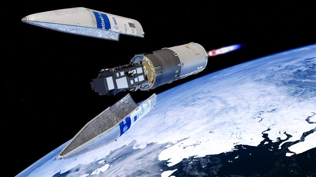
Follow the Sentinel-3B launch live. The satellite lifted off today at 17:30 GMT (19:30 CEST). Streaming resumes at 19:15 GMT (21:10 CEST) for acquisition of signal
ESA teams ready for space
24.4.2018 13:42 ESA Observing the Earth
Tomorrow’s launch of Sentinel-3B will complete the Sentinel-3 constellation and represents the culmination of months of training to fly Europe’s latest Copernicus satellite.
20180424 - Zrušení podpory prozatímního kódu 102067 pro síťové služby k 31.5.2018
24.4.2018 12:59 ČÚZK - Výměnný formát ISKN V roce 2011 byla v prohlížecích a následně stahovacích službách resortu ČÚZK zavedena podpora kódu EPSG 5514 pro poskytování služeb v souřadnicovém systému S-JTSK / Krovak East North, který je standardizován v rámci mezinárodního registru souřadnicových referenčních systémů. Byl tak zahájen přechod od dosud užívaného alternativního kódu 102067, který byl užíván pro stejný souřadnicový systém, nicméně nebyl v EPSG standardizován. K datu 1. 7. 2017 byl dokončen přechod ke standardnímu kódu EPSG 5514. Ve všech prohlížecích a stahovacích službách resortu ČÚZK bude zrušena podpora alternativního kódu 102067 k 31.5.2018. Odstranění duplicity a používání pouze standardizovaného kódu umožní na straně poskytovatele služeb zjednodušení konfigurace a tím i zvýšení výkonu služeb.20180424 - Zrušení podpory prozatímního kódu 102067 pro síťové služby k 31.5.2018
24.4.2018 12:59 ČÚZK - Výměnný formát ISKN V roce 2011 byla v prohlížecích a následně stahovacích službách resortu ČÚZK zavedena podpora kódu EPSG 5514 pro poskytování služeb v souřadnicovém systému S-JTSK / Krovak East North, který je standardizován v rámci mezinárodního registru souřadnicových referenčních systémů. Byl tak zahájen přechod od dosud užívaného alternativního kódu 102067, který byl užíván pro stejný souřadnicový systém, nicméně nebyl v EPSG standardizován. K datu 1. 7. 2017 byl dokončen přechod ke standardnímu kódu EPSG 5514. Ve všech prohlížecích a stahovacích službách resortu ČÚZK bude zrušena podpora alternativního kódu 102067 k 31.5.2018. Odstranění duplicity a používání pouze standardizovaného kódu umožní na straně poskytovatele služeb zjednodušení konfigurace a tím i zvýšení výkonu služeb.Watch Sentinel-3B launch
24.4.2018 12:10 ESA Observing the EarthFollow the Sentinel-3B launch live from the Plesetsk Cosmodrome in Russia on 25 April. Streaming begins at 17:30 GMT (19:30 CEST), with liftoff scheduled at 17:57 GMT (19:57 CEST)
Blíží se čtvrtý ročník konference Mapy jsou pro každého
24.4.2018 11:58 GeoBusiness Čtvrtý ročník konference Mapy jsou pro každého se blíží. Organizátoři pracují na finálním programu a uveřejnili ochutnávku, na jaké referáty se můžete těšit. Senzorová ... PřečístGNSS: addressing the challenges of Arctic navigation
24.4.2018 11:47 European GNSS Agency
Participants in the Challenges in Arctic Navigation workshop in Olos, Muonio, Finland on April 16-18 discussed how GNSS can address some of the difficulties posed by navigation in the Arctic, in addition to how satellite navigation itself can be improved in the region, which is also a challenging environment for GNSS.
The Challenges in Arctic Navigation workshop was held under the Finnish Chairmanship of the Arctic Council. The workshop was organised by the Ministry and Communications (Mrs Seija Miettinen-Bellevergue) and the Finnish Geospatial Research Institute (Prof. Heidi Kuusniemi) and funded by the Ministry of Foreign Affairs.
A number of challenges to both conventional and satellite navigation were highlighted during the conference. These range from severe climatic and ice conditions, to the long distances involved in navigating in the region, all of which result in longer emergency response times for search and rescue. The challenge of sparse telecommunications coverage in the Arctic was also highlighted.
Low EGNOS coverage due to the poor visibility of geostationary (GEO) satellites received a lot of attention. This was highlighted as a significant obstacle to the expansion of SBAS-based navigation in Arctic aviation. Specifically, poor EGNOS LPV 200 coverage in the North and the Arctic means that it is not possible to use this service for landing aircraft. New satellite constellations in low-Earth or highly elliptic orbits were seen as a promising solution. Some participants also noted specific challenges with the reception of GNSS signals at Auroral latitudes.

In addition to GNSS and telecommunications, navigation in the Arctic also benefits from other space-based technologies, especially in the maritime domain. "Sea currents are chaotic and not well predictable if satellite images are not available," Veli Luukkala, Chief Officer at Arctia Icebreaking Ltd., said.
While acknowledging these challenges in his address at the conference, Gian Gherardo Calini, the GSA’s Head of Market Development, also stressed some of the opportunities offered by EGNSS for different applications. The ones coming from implementation of EGNOS based procedures in aviation are: improved accessibility and operational capability, reduced environmental impacts and costs, infrastructure rationalisation, and increased safety. With regard to the low level of EGNOS coverage, he said that extension of the commitment areas for APV-I, NPA and LPV-200 up to 72ºN in Norway and Finland is planned for 2018 according to the EGNOS SoL Implementation Roadmap.
Watch this: EGNOS is growing
Regarding the issue of emergency response times, Calini said that, with the increased positioning accuracy provided by Galileo integrated into COSPAS-SARSAT, users would benefit from reduced detection times, improved localisation, increased availability and the return link function. “If a person in distress knows that their message has been heard and that help is on the way, this is very important. This is a key differentiator of Galileo,” he said.
In his address at the workshop, Eric Guyader, Galileo Programme Administrator at the European Commission, said that since 2013, the European Commission has been developing modernisation plans for Galileo, to ensure that the system can respond to new challenges in the use of GNSS. He said that the EC’s approach is to capture the strategic priorities of the Member States, including in the Arctic, and to understand the changing GNSS environment.
Regarding the specific challenges posed by the Arctic region, he said that the Commission is in open dialogue with countries in the region to establish priorities. He said that Galileo provides good service overall in both navigation and SAR, and that, in combination with GPS and GLONASS, it would offer excellent service.
Guyader said that the Galileo modernisation includes plans for Advanced Receiver Autonomous Integrity Monitoring (ARAIM), and emergency warning service and an ionosphere prediction service, which will make it possible to quickly react to sudden signal degradation.
In another presentation, a representative from academia noted that ionospheric scintillation, or the rapid modification of radio waves by small-scale structures in the ionosphere, was an important concern in the Arctic, primarily for service availability and continuity, rather than integrity. He said that dual-frequency GNSS offered a possible solution, as it would allow users to directly and robustly estimate ionospheric delay.
A potential solution to the problem of poor visibility of GEO satellites was offered by Kjersti Moldekelev, Senior Adviser at the Norwegian Space Centre. Moldeklev said that the company Space Norway was planning to launch HEO satellites in 2022, which would provide broadband access to the Arctic region. She said that if these HEO satellites were to carry SBAS payload, this would give the EU a foothold in the Arctic. "This will definitely be a solution for communications challenges in the region and perhaps for navigation challenges also,” she said.
Local stakeholders in Arctic navigation were well represented at the workshop, including the Finnish Defence Forces, the Finnish Communications Regulatory Authority, and companies such as Finnair, KNL Networks, and Reaktor. The stakeholders actively contributed to the workshop by giving keynote addresses, participating in panel discussions, and working in expert groups to build a roadmap towards resolving the challenges of Arctic navigation.
Media note: This feature can be republished without charge provided the European GNSS Agency (GSA) is acknowledged as the source at the top or the bottom of the story. You must request permission before you use any of the photographs on the site. If you republish, we would be grateful if you could link back to the GSA website (http://www.gsa.europa.eu).
GNSS: addressing the challenges of Arctic navigation
24.4.2018 11:47 European GNSS AgencyParticipants in the Challenges in Arctic Navigation workshop in Olos, Muonio, Finland on April 16-18 discussed how GNSS can address some of the difficulties posed by navigation in the Arctic, in addition to how satellite navigation itself can be improved in the region, which is also a challenging environment for GNSS.
The Challenges in Arctic Navigation workshop was held under the Finnish Chairmanship of the Arctic Council. The workshop was organised by the Ministry and Communications (Mrs Seija Miettinen-Bellevergue) and the Finnish Geospatial Research Institute (Prof. Heidi Kuusniemi) and funded by the Ministry of Foreign Affairs.
A number of challenges to both conventional and satellite navigation were highlighted during the conference. These range from severe climatic and ice conditions, to the long distances involved in navigating in the region, all of which result in longer emergency response times for search and rescue. The challenge of sparse telecommunications coverage in the Arctic was also highlighted.
Low EGNOS coverage due to the poor visibility of geostationary (GEO) satellites received a lot of attention. This was highlighted as a significant obstacle to the expansion of SBAS-based navigation in Arctic aviation. Specifically, poor EGNOS LPV 200 coverage in the North and the Arctic means that it is not possible to use this service for landing aircraft. New satellite constellations in low-Earth or highly elliptic orbits were seen as a promising solution. Some participants also noted specific challenges with the reception of GNSS signals at Auroral latitudes.
Challenges and opportunities were discussed in Arctic navigation in Olos, Muonio
In addition to GNSS and telecommunications, navigation in the Arctic also benefits from other space-based technologies, especially in the maritime domain. "Sea currents are chaotic and not well predictable if satellite images are not available," Veli Luukkala, Chief Officer at Arctia Icebreaking Ltd., said.
While acknowledging these challenges in his address at the conference, Gian Gherardo Calini, the GSA’s Head of Market Development, also stressed some of the opportunities offered by EGNSS for different applications. The ones coming from implementation of EGNOS based procedures in aviation are: improved accessibility and operational capability, reduced environmental impacts and costs, infrastructure rationalisation, and increased safety. With regard to the low level of EGNOS coverage, he said that extension of the commitment areas for APV-I, NPA and LPV-200 up to 72ºN in Norway and Finland is planned for 2018 according to the EGNOS SoL Implementation Roadmap.
Watch this: EGNOS is growing
Regarding the issue of emergency response times, Calini said that, with the increased positioning accuracy provided by Galileo integrated into COSPAS-SARSAT, users would benefit from reduced detection times, improved localisation, increased availability and the return link function. “If a person in distress knows that their message has been heard and that help is on the way, this is very important. This is a key differentiator of Galileo,” he said.
In his address at the workshop, Eric Guyader, Galileo Programme Administrator at the European Commission, said that since 2013, the European Commission has been developing modernisation plans for Galileo, to ensure that the system can respond to new challenges in the use of GNSS. He said that the EC’s approach is to capture the strategic priorities of the Member States, including in the Arctic, and to understand the changing GNSS environment.
Regarding the specific challenges posed by the Arctic region, he said that the Commission is in open dialogue with countries in the region to establish priorities. He said that Galileo provides good service overall in both navigation and SAR, and that, in combination with GPS and GLONASS, it would offer excellent service.
Guyader said that the Galileo modernisation includes plans for Advanced Receiver Autonomous Integrity Monitoring (ARAIM), and emergency warning service and an ionosphere prediction service, which will make it possible to quickly react to sudden signal degradation.
In another presentation, a representative from academia noted that ionospheric scintillation, or the rapid modification of radio waves by small-scale structures in the ionosphere, was an important concern in the Arctic, primarily for service availability and continuity, rather than integrity. He said that dual-frequency GNSS offered a possible solution, as it would allow users to directly and robustly estimate ionospheric delay.
A potential solution to the problem of poor visibility of GEO satellites was offered by Kjersti Moldekelev, Senior Adviser at the Norwegian Space Centre. Moldeklev said that the company Space Norway was planning to launch HEO satellites in 2022, which would provide broadband access to the Arctic region. She said that if these HEO satellites were to carry SBAS payload, this would give the EU a foothold in the Arctic. "This will definitely be a solution for communications challenges in the region and perhaps for navigation challenges also,” she said.
Local stakeholders in Arctic navigation were well represented at the workshop, including the Finnish Defence Forces, the Finnish Communications Regulatory Authority, and companies such as Finnair, KNL Networks, and Reaktor. The stakeholders actively contributed to the workshop by giving keynote addresses, participating in panel discussions, and working in expert groups to build a roadmap towards resolving the challenges of Arctic navigation.
Media note: This feature can be republished without charge provided the European GNSS Agency (GSA) is acknowledged as the source at the top or the bottom of the story. You must request permission before you use any of the photographs on the site. If you republish, we would be grateful if you could link back to the GSA website (http://www.gsa.europa.eu).
Naučte se PROLAND, program pro pozemkové úpravy
24.4.2018 11:34 GeoBusiness Firma Gepro zve na pracovní seminář, určený všem zpracovatelům pozemkových úprav. Ve středu 30. května 2018 se v prostorách společnosti GEPRO uskuteční seminář, určený ... PřečístPozvánka na seminář PROLAND 30.5.2018
24.4.2018 10:38 GEPROVe středu 30. května 2018 se v prostorách společnosti GEPRO uskuteční seminář určený především zpracovatelům komplexních pozemkových úprav na téma: PROLAND – zpracování etap RSS a PSZ.… >>
Aktualizace dat v mapových aplikacích
24.4.2018 10:30 Jihočeský kraj Mapová aplikace Technická infrastruktura a mapová aplikace Zastavěné území byly aktualizovány k 24.4.2018.USGIF Announces First K. Stuart Shea Endowed Scholarship Recipient
24.4.2018 10:22 GISCafe.com Webcasts-Webinars The USGIF Board of Directors awards inaugural scholarship to Rochester Institute of Technology imaging science studentTampa, Florida (April 23, …
Orbit GT and 3G-Consult, Tunisia, sign Reseller Agreement
24.4.2018 10:08 GISCafe.com Webcasts-Webinars Lokeren, Belgium, April 20th, 2018 - Orbit GT is pleased to announce that 3G-Consult, Tunisia, has joined as Authorized Reseller of Orbit GT 3D …Nové verze 13.28
24.4.2018 9:45 GEPROZveřejnili jsme verze 13.28 našich produktů MISYS, MISYS-WEB, KOKEŠ, a PROLAND.
Stahovat je můžete z obvyklého umístění na našem download serveru:
… >>Nové verze 13.28
24.4.2018 9:45 GEPROZveřejnili jsme verze 13.28 našich produktů MISYS, MISYS-WEB, KOKEŠ, a PROLAND.
Stahovat je můžete z obvyklého umístění na našem download serveru:
… >>Nové verze 13.28
24.4.2018 9:45 GEPROZveřejnili jsme verze 13.28 našich produktů MISYS, MISYS-WEB, KOKEŠ, a PROLAND.
Stahovat je můžete z obvyklého umístění na našem download serveru:
… >>Nové verze 13.28
24.4.2018 9:45 GEPROZveřejnili jsme verze 13.28 našich produktů MISYS, MISYS-WEB, KOKEŠ, a PROLAND.
Stahovat je můžete z obvyklého umístění na našem download serveru:
… >>Živé přenosy aktivit ESA na ILA
24.4.2018 9:44 Český Kosmický PortálEvropská kosmická agentura se bude v následujících dnech prezentovat na mezinárodním aerosalónu ILA. Ten se uskuteční od 25. do 29. dubna na letišti Berlin ExpoCenter Airport.
Živé přenosy aktivit ESA na ILA
24.4.2018 9:44 Český Kosmický PortálEvropská kosmická agentura se bude v následujících dnech prezentovat na mezinárodním aerosalónu ILA. Ten se uskuteční od 25. do 29. dubna na letišti Berlin ExpoCenter Airport.
20180424-Popis změn v oblasti poskytování údajů z KN
24.4.2018 7:28 ČÚZK - předpisy a opatření Český úřad zeměměřický a katastrální zveřejnil novou aktualitu: Na stránce Podrobné informace VF ISKN byl doplněn dokument s popisem změn v oblasti poskytování údajů z katastru nemovitostí ve výměnném formátu, ke kterému má dojít v letošním roce v důsledku účinnosti Obecného nařízení o ochraně osobních údajů (GDPR) a jsou zveřejněny podrobné technické specifikace (xml, wsdl).20180424-Popis změn v oblasti poskytování údajů z KN
24.4.2018 7:28 ČÚZK /Aktuality-resort/2018/20180424-Popis-zmen-v-oblasti-poskytovani-udaju-z20180424-Popis změn v oblasti poskytování údajů z KN
24.4.2018 7:28 ČÚZK - předpisy a opatření Český úřad zeměměřický a katastrální zveřejnil novou aktualitu: Na stránce Podrobné informace VF ISKN byl doplněn dokument s popisem změn v oblasti poskytování údajů z katastru nemovitostí ve výměnném formátu, ke kterému má dojít v letošním roce v důsledku účinnosti Obecného nařízení o ochraně osobních údajů (GDPR) a jsou zveřejněny podrobné technické specifikace (xml, wsdl).Digitally Integrated Operations by Siemens
24.4.2018 2:00 Bentley SystemsPress Coverage
ARCView, USA
Read the articleZákladní hydrogeologická mapa Československa 1 : 200 000 - území ČR (rastr)
24.4.2018 2:00 Cenia - Katalog metadat ČR - INSPIRE ArcGIS Server služba pro zpřístupnění hydrogeologických map v měřítku 1 : 200 000 z území ČR, které zahrnuje 15 mapových listů z celé série pro oblast bývalého Československa. WMS byla vytvořena z rastrového podkladu.Comprehensive 3D Digital Design on a China Hydropower Project Saves USD 300 Million
24.4.2018 2:00 Bentley SystemsPress Coverage
Lidar News, USA
Read the articleČGS Podložní a povrchová geologie - OneGeology-Europe - anglická verze
24.4.2018 2:00 Cenia - Katalog metadat ČR - INSPIRE INSPIRE prohlížecí služba zobrazující datovou sadu GeoCR500, která byla vytvořena pro účely projektu OneGeology-Europe. Aktualizovaná v rámci projektu EGDI v roce 2016.Is construction ready for the driverless revolution?
24.4.2018 2:00 Bentley SystemsPress Coverage
Construction News, UK
Read the articleHlásná síť podzemních vod
24.4.2018 2:00 Cenia - Katalog metadat ČR - INSPIRE Jedná se o podmnožinu pozorovaných objektů PzV – mělkých a hlubokých vrtů i pramenů, které reprezentují danou zvodeň a mají kvalitní řadu pozorování v letech 1981 - 2010. Z výsledků měření v této části sítě se každý týden a měsíc připravuje zpráva a soustava map, která charakterizuje „Stav podzemních vod“. V těchto mapách se srovnávají změny hladin ve vrtech a vydatností v pramenech vůči předchozímu týdnu a měsíci nebo se stejným týdnem a měsícem předchozího roku, dále se hodnotí hladina a vydatnost podle pravděpodobnosti překročení pro hodnocený týden a měsíc. V roce 2018 je do hlásné sítě zařazeno 161 pramenů, 78 hlubokých a 200 mělkých vrtů.Seminář Komplexní pozemkové úpravy – nástroj rozvoje venkovské krajiny
24.4.2018 0:00 Státní pozemkový úřadPresagis Solution Helps Intelligence Sector
23.4.2018 20:20 GISCafe.com Webcasts-Webinars April 23 2018 – Tampa, Florida – Presagis™, a recognized leader in simulation software, is providing VELOCITY, a next-generation …Water Utility Management
23.4.2018 19:33 Bentley SystemsPress Coverage
Water World, USA
Read the articleEsri Releases ArcGIS Pro Workstation Customized for the Intelligence Community
23.4.2018 19:21 GISCafe.com Webcasts-Webinars New Desktop Configuration Gives Analysts Activity-BasedIntelligence and Foundational Data Management Capabilities
REDLANDS, Calif. …
Maxar Technologies’ DigitalGlobe Introduces Rapid Access Program, A Powerful Online Portal Providing Customers Fast, Flexible Priority Access to the World’s Highest Resolution Commercial Satellites
23.4.2018 19:20 GISCafe.com Webcasts-Webinars WESTMINSTER, Colo. — (BUSINESS WIRE) — April 23, 2018 —DigitalGlobe,
a Maxar Technologies company (formerly …
Engility unveils MetaSift™
23.4.2018 19:20 GISCafe.com Webcasts-Webinars Groundbreaking data analytics integration platform developed for intelligence communityTAMPA, Fla., April 23, 2018 — (PRNewswire) — …
Hemisphere GNSS' Flexible & Scalable GradeMetrix™ Toolkit Empowers OEMs to Build Branded GNSS-Based Machine Control & Guidance IP
23.4.2018 19:19 GISCafe.com Webcasts-Webinars Hemisphere's GradeMetrix hardware and software components empowers OEMs to build their own branded systems with a la carte or complete-solution …Vricon unveils new solution at GEOINT 2018: Vricon Precision 3D Registration (P3DR)
23.4.2018 19:18 GISCafe.com Webcasts-Webinars McLean, Virginia, April 23, 2018 (GLOBE NEWSWIRE) -- Vricon is pleased to announce that it is unveiling the next in a series of GEOINT …Studujte doktorský obor Geoinformatika
23.4.2018 13:48 Vážení budoucí absolventi, inženýři, magistři, uvažujete o doktorském studiu? Podívejte se na přehled nabízených témat pro studium doktorského studijního oboru Geoinformatika. Využijte možnosti se zapojit do projektů, řešit do hloubky “svou” oblast, strávit čas v zahraničí na univerzitách v západní Evropě, poznejte svět skrze účasti na mezinárodních konferencích, vypilujte si angličtinu, prostě staňte se doktorem! […]Obchodní referent
23.4.2018 13:23 ČÚZK - volná místa Zeměměřický úřad vypisuje výběrové řízení na místo Obchodní referentObchodní referent
23.4.2018 13:23 ČÚZK - předpisy a opatření Zeměměřický úřadvypisuje výběrové řízení na místo
Obchodní referent