


![]()

zprávy
zdroje zpráv:Profiling the wind
20.2.2018 11:50 ESA Observing the Earth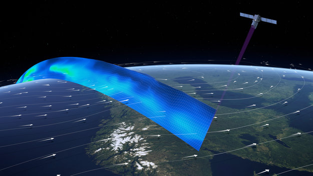
Scheduled to be launched later this year, ESA’s Earth Explorer Aeolus mission will be the first satellite mission to profile the world’s winds from space
Kartografický den již tento pátek!
20.2.2018 11:25 Česká kartografická společnost 12. kartografický den v Olomouci, v tomto ročníku se zaměřením kartografii a 3D vizualizaci, se koná již tento pátek! Více informací a registrace na seminář jsou k dispozici ZDE.GIS Ostrava 2018 pod záštitou ČKS
20.2.2018 11:23 Česká kartografická společnost Symposium GIS Ostrava 2018, s tématem GIS pro podporu bezpečnosti a krizového řízení, se uskuteční 21.–23. března 2018 v prostorách VŠB-TU Ostrava. Letošní ročník je opět pod záštitou České kartografické společnosti a členové ČKS mají slevu na vložném. Uzávěrka pro registraci příspěvků je již 23. 2. 2018. Více informací a registrace jsou k dispozici ZDE.Chtěli byste dělat koordinátora městské mobility?
20.2.2018 10:36 Blogující geomatici - FAV ZČU Magistrát města Most vyhlašuje výběrové řízení na pozici koordinátor městské mobility. Více informací na přiložených obrázcích.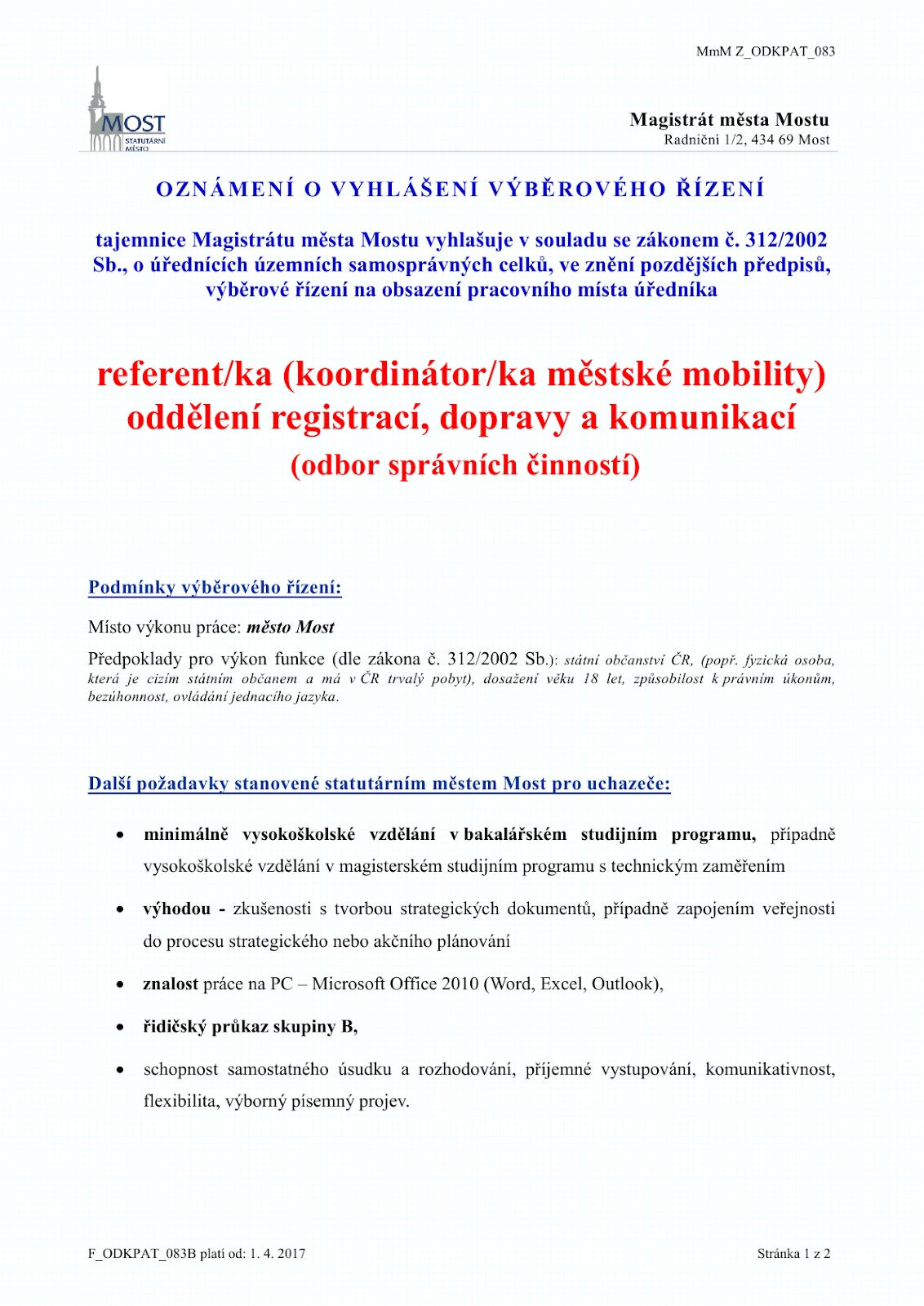
WOC brings industry engagement to the international arctic research icebreaker consortium (arice) launched in bremerhaven
20.2.2018 10:29 GISCafe.com Webcasts-Webinars The ARICE Consortium Launched Last Week, with the World Ocean Council as the Lead Partner to Ensure Industry Interaction with the Arctic Marine …WOC BRINGS INDUSTRY ENGAGEMENT TO THE INTERNATIONAL ARCTIC RESEARCH ICEBREAKER CONSORTIUM (ARICE) LAUNCHED IN BREMERHAVEN
20.2.2018 10:29 GISCafe.com Webcasts-Webinars The ARICE Consortium Launched Last Week, with the World Ocean Council as the Lead Partner to Ensure Industry Interaction with the Arctic Marine …Leibniz Universität Hannover: 3 year PhD position
20.2.2018 10:24 In the context of a DFG-funded Research Training Group (RTG) SocialCars, the Institute of Cartography and Geoinformatics (ikg) offers A position of a Doctoral Researchers (salary scale 13TV-L, 3 years) starting at 1.4.2018. The overall objective of the SocialCars RTG is to research new methods and applications of decentralized, cooperative traffic management. The SocialCars RTG […]Seznamovali jsme s drony startupy v ESA BIC Prague
20.2.2018 9:53 UpVision V minulém týdnu jsme na workshopu Drony určeném pro startupy v ESA BIC Prague seznamovali s problematikou dronů, jejich přehledem, potenciálem a aktuálními výzvami na trhu.Několik fotografií zde:
https://plus.google.com/u/0/b/115833877689730865211/+UpvisionCz1/posts/NHD3pHQfve2
Vypouštěcí stůl pro Ariane 6 začíná získávat svoji podobu
20.2.2018 9:50 Český Kosmický PortálVypouštěcí stůl, který bude zajišťovat podporu raket Ariane 6 na startovací rampě, začíná na evropském kosmodromu ve Francouzské Guayaně získávat svůj tvar.
Vypouštěcí stůl pro Ariane 6 začíná získávat svoji podobu
20.2.2018 9:50 Český Kosmický PortálVypouštěcí stůl, který bude zajišťovat podporu raket Ariane 6 na startovací rampě, začíná na evropském kosmodromu ve Francouzské Guayaně získávat svůj tvar.
Airbus awarded EGNOS V3 contract
20.2.2018 9:26 European GNSS AgencyAirbus has been selected as the main contractor to develop EGNOS V3, the next generation of Europe’s Satellite Based Augmentation System (SBAS). The company was awarded the contract by the European Space Agency (ESA), which manages EGNOS development under a working arrangement signed with the European GNSS Agency (GSA).
For the next generation of the EGNOS augmentation system, the GSA requested the complete overhaul of the EGNOS ground segment, which was becoming obsolete. This modernisation programme will see the deployment of EGNOS V3 in ground stations at more than 50 sites in Europe, and surrounding countries.
The GSA also requested the development of new EGNOS capabilities to support the augmentation of a second GPS signal (L5) and of the Galileo signals E1-E5. Another requirement is that the system be made more robust, to deal with the increase in user numbers and to reflect their increasing dependence on EGNOS and its ground applications - in some countries (e.g. France) instrument landing systems (ILS) are being decommissioned on several airports because the civil aviation authorities have decided instead to rely on EGNOS.
Comprehensive modernisation programme
Under the contract, which was signed on January 26 2018, the ESA and Airbus will provide the GSA with two EGNOS upgrade versions. EGNOS V3.1 will ensure continuity of EGNOS augmentation of GPS L1, but with a more resilient performance, while EGNOS V3.2 will support a new SBAS service, transmitting on the L5 frequency, which will augment Galileo L1/E1 – L5/E5 along with GPS.
Watch this: EGNOS for Aviation
The GSA’s request for EGNOS V3 development is part of its overall EGNOS modernisation programme that also includes renewal of the space segment. As part of this programme, the GSA has contracted Eutelsat for the preparation and service provision phases of the EGNOS GEO-3 payload, to be hosted on the EUTELSAT 5 West B satellite that is due to be launched this year. Furthermore, the GSA will soon publish a request for information (RFI) on opportunities to deploy future new EGNOS payloads.
The programme also covers Europe’s contribution to the development of new SBAS standards for aviation in coordination with ICAO, RTCA and EUROCAE, and the development of a prototype of the SBAS-DFMC multi-frequency (L1-L5), multi-constellation (Galileo-GPS) receiver for aviation, which is being developed by Thales Avionics. After 2025, SBAS-DFMC users will be able to use the new service thanks to EGNOS L5 geo-stationary signals.
Seamless transition
In parallel with the EGNOS modernisation programme, the GSA, with the support of ESSP, ESA and TAS-F, is maintaining the efficient operation of EGNOS V2 until it is time to move to EGNOS V3. For current EGNOS users, the transition between EGNOS V2 and EGNOS V3 will be seamless, as the new system is being developed with backward compatibility.
Media note: This feature can be republished without charge provided the European GNSS Agency (GSA) is acknowledged as the source at the top or the bottom of the story. You must request permission before you use any of the photographs on the site. If you republish, we would be grateful if you could link back to the GSA website (http://www.gsa.europa.eu).
Hledáme: Specialista mobilního mapování
20.2.2018 7:00 TopGis Společnost TopGis, s.r.o. vypisuje výběrové řízení na pozici „Specialista mobilního mapování“ na DPP nebo DPČ na dobu určitou 03/2018 – 10/2018 Pracovní náplň: Požadavky: Pracoviště: Pracovní poměr formou DPP nebo DPČ na dobu určitou 03/2018 – 10/2018 V případě Vašeho zájmu nám pošlete Váš strukturovaný životopis na emailovou adresu kariera@topgis.cz. Odpovědí na inzerát či zasláním Vašeho životopisu aINSPIRE datová sada pro téma Zeměpisná jména (GN)
20.2.2018 1:00 Cenia - Katalog metadat ČR - INSPIRE Data INSPIRE tématu Zeměpisná jména jsou harmonizována dle prováděcích pravidel INSPIRE a odpovídají INSPIRE xml schématu ve verzi 4.0 a ELF xml schématu ve verzi 1.0. Tato datová sada geografických jmen České republiky má proto jednotnou podobu s ostatními daty vytvářenými pro toto INSPIRE téma v rámci celé Evropy. Objekty jsou reprezentovány vektorovou (bodovou) složkou s atributy, které obsahují další informace o jménech. Základem datové sady je databáze geografických jmen České republiky Geonames, ke které jsou doplněna jména objektů, které jsou obsažena v Základní bázi geografických dat České republiky (ZABAGED®), ale nejsou součástí Geonames (jména ulic a náměstí, dopravních uzlů a chráněných území). Atributy jsou vyplněny na základě obsahu zdrojových databází, případně konstantně na základě vlastností zdrojových databází (např. všechna jména jsou endonyma v češtině, jména přebíraná z Geonames jsou standardizovaná, jména ulic jsou oficiální apod.)Základní báze geografických dat České republiky (ZABAGED®) - polohopis
20.2.2018 1:00 Cenia - Katalog metadat ČR - INSPIRE Základní báze geografických dat České republiky (ZABAGED®) je digitální geografický model území České republiky (ČR). Polohopisnou část ZABAGED® tvoří v současné době 119 typů geografických objektů sídel, komunikací, rozvodných sítí a produktovodů, vodstva, územních jednotek a chráněných území, vegetace a povrchu, terénního reliéfu a vybrané údaje o geodetických bodech. Objekty jsou reprezentovány dvourozměrnou vektorovou prostorovou složkou a popisnou složkou, obsahující kvalitativní a kvantitativní informace o objektech.INSPIRE prohlížecí služba WMS pro téma Zeměpisná jména (GN)
20.2.2018 1:00 Cenia - Katalog metadat ČR - INSPIRE INSPIRE prohlížecí služba WMS pro téma Zeměpisná jména (GN) poskytuje možnost prohlížet obraz dat INSPIRE tématu Zeměpisná jména. Data jsou harmonizována dle prováděcích pravidel INSPIRE. Služba splňuje Technické pokyny pro INSPIRE prohlížecí služby v. 3.11 a zároveň splňuje standard OGC WMS 1.1.1. a 1.3.0.Next Step in the Microdrones and Trimble Partnership: Seamless Integration with Trimble Business Center Software
19.2.2018 17:25 GISCafe.com Webcasts-Webinars Rome, NY USA, Feb. 19, 2018 (GLOBE NEWSWIRE) -- As the preferred provider of Vertical Take Off and Landing drone systems to the Trimble network of …Olympiáda v mapách
19.2.2018 15:34 ARCDATAZimní olympijské hry v Pchjongčchangu jsou velké téma také v mapách s příběhem. Prohlédněte si tři zajímavé aplikace, které se věnují medailovým ziskům, sportovištím a historickým statistikám.
Medailové zisky na ZOH | Historické statistiky ZOH | Sportoviště ZOH |


Geoteam Systems hledá geodety
19.2.2018 13:18 Blogující geomatici - FAV ZČU Informace v přiloženém letáku.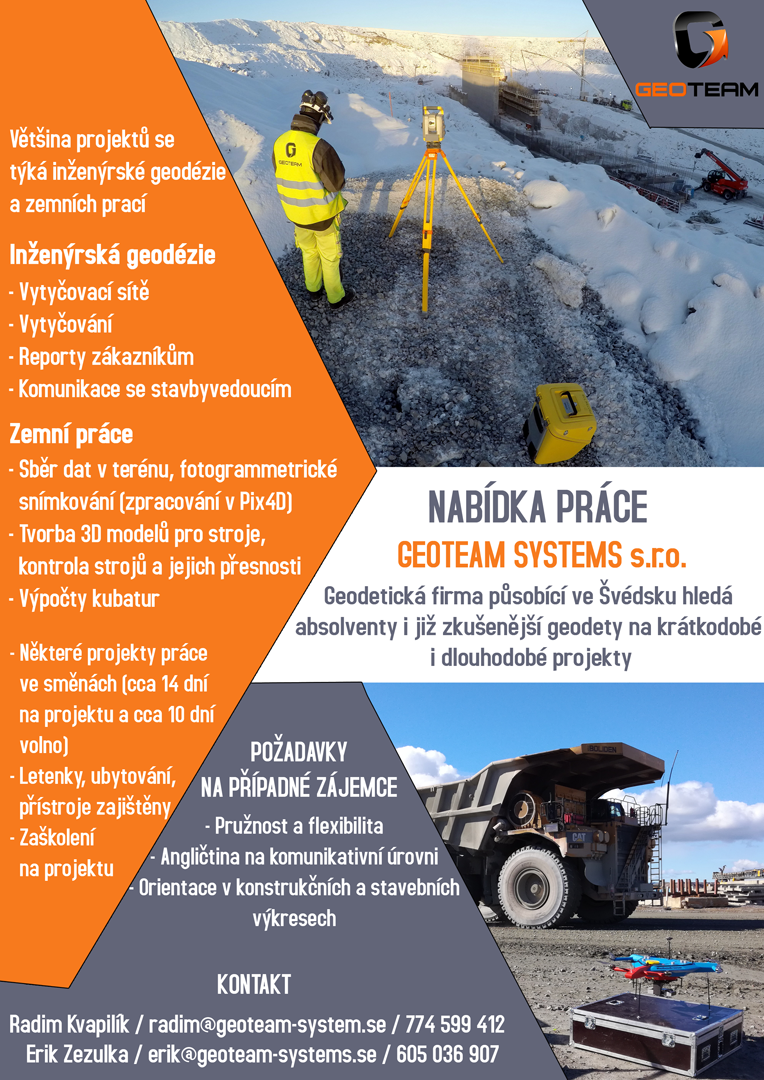
GSC portal reaches 1000 registered users
19.2.2018 9:41 European GNSS Agency
On Friday 9 February 2018, the web portal of the European GNSS Service Centre (GSC) registered its 1000th user. This is a great achievement for the broader GNSS community and for the European GNSS Programmes (EGNOS and Galileo) in particular.
The GSC web portal entered into service in 2013 and, since then, it has received more than 175,000 visits from over 190 different countries around the globe. Every month over 20 new users register on the portal, bringing the current total to more than 1,000 registrations. The most downloaded document from the website is the Galileo IS OS Service Definition Document (SDD).
Read this: GSC showcased at First Galileo User Assembly
If you are not yet registered on the GSC site, we invite you to register so that, among other things, you will be able to subscribe to the Galileo service notifications (NAGUs) as well as gain access to the Galileo official Helpdesk.
GSC at a glance
Located in Madrid, the European GNSS Service Centre is an integral part of the European GNSS infrastructure. It provides a single interface for the Galileo Open Service (OS) and Commercial Service (CS) user communities and offers specific added-value services beyond the Galileo Signal-In-Space (SIS) transmitted by the operational satellites.
The GSC is conceived as a centre of expertise, knowledge sharing, custom performance assessment, and information dissemination. The GSC serves the user community through its web portal. This one-stop-shop portal provides Galileo users with relevant infor¬mation on the system’s status and easy access to the dedicated Helpdesk. In addition, an automatic alert system notifies registered users about events affecting the Galileo services.
Media note: This feature can be republished without charge provided the European GNSS Agency (GSA) is acknowledged as the source at the top or the bottom of the story. You must request permission before you use any of the photographs on the site. If you republish, we would be grateful if you could link back to the GSA website (http://www.gsa.europa.eu).
Měníme hosting a server – budeme zpět 23.2.
19.2.2018 8:20 GISportal.cz
Po sedmi letech měníme hosting, design, apod. takže nám prosím dejte pár dní, aby bylo vše ok. 23.2. vše sputíme a máme pro Vás plno překvapení! Do té doby nám prosím držte palce!!!
The post Měníme hosting a server – budeme zpět 23.2. appeared first on GISportal.cz.
Měníme hosting a server – budeme zpět 23.2.
19.2.2018 8:20 GISportal.czMěníme hosting a server – budeme zpět 23.2.
19.2.2018 8:20 GISportal.czPo sedmi letech měníme hosting, design, apod. takže nám prosím dejte pár dní, aby bylo vše ok. 23.2. vše sputíme a máme pro Vás plno překvapení! Do té doby nám prosím držte palce!!!
The post Měníme hosting a server – budeme zpět 23.2. appeared first on GISportal.cz.
Měníme hosting a server – budeme zpět 23.2.
19.2.2018 8:20 GISportal.cz Po sedmi letech měníme hosting, design, apod. takže nám prosím dejte pár dní, aby bylo vše ok. 23.2. vše sputíme a máme pro Vás plno překvapení! Do té doby nám prosím držte palce!!!Zeměměřický úřad hledá geografa-fotogrammetra
19.2.2018 7:00 Česká asociace pro geoinformace Pro oddělení sběru dat v Pardubicích hledá Zeměměřický úřad zaměstnance na pozici geograf-fotogrammetr. Předpokládaný datum nástupu je 1. března 2019. Náplní práce bude vyhodnocení výškopisu na základě dat z leteckého laserového skenování a leteckého měřického snímkování a zpracování dat objektů a atributů ZABAGED v aplikaci pro vedení databáze.Pozvánka na semináře Roll-out 2019
19.2.2018 7:00 Česká asociace pro geoinformaceDopřejte si zajímavý začátek nového roku a přihlaste na seminář Roll-out 2019, který pořádajají ARCDATA Praha. Těšit se můžete na novinky ze světa ArcGIS a ENVI, které Vám usnadní každodenní práci s geodaty, i na setkání s kolegy z Vašeho okolí.
Co bude na programu
novinky v ArcGIS Pro 2.3,
zajímavosti v oblasti webového GIS,
Insights for ArcGIS
Odborný referent/vrchní referent v oddělení právních vztahů k nemovitostem na Katastrálním pracovišt
19.2.2018 6:30 ČÚZK /Urady/Katastralni-urady/Katastralni-urady/Katastralni-urad-pro-Jihomoravsky-kraj/Uredni-deska/Oznameni-a-jina-uredni-sdeleni/Volna-mista/Odborny-referent-vrchni-referent-v-oddeleni-pr-(1)Odborný referent/vrchní referent v oddělení právních vztahů k nemovitostem na Katastrálním pracovišt
19.2.2018 6:30 ČÚZK - předpisy a opatření Katastrální úřad pro Jihomoravský kraj - Katastrální pracoviště Kyjovvypisuje výběrové řízení na místo
Odborný referent/vrchní referent v oddělení právních vztahů k nemovitostem na Katastrálním pracovišti Kyjov
Odborný referent/vrchní referent v oddělení právních vztahů k nemovitostem na Katastrálním pracovišt
19.2.2018 6:30 ČÚZK - volná místa Katastrální úřad pro Jihomoravský kraj - Katastrální pracoviště Kyjov vypisuje výběrové řízení na místo Odborný referent/vrchní referent v oddělení právních vztahů k nemovitostem na Katastrálním pracovištNálezová data
19.2.2018 1:00 Cenia - Katalog metadat ČR - INSPIRE Data o výskytu (pozováních, nálezech) druh živočichů, rostlin, hub a dalších organismů. Data jsou georeferencována. Původcem dat je jednak AOPK ČR (jsou výsledkem jejích současných i historických průzkumných aktivit), jednak široká množina dalších subjektů (včetně akademické sféry a široké veřejnosti). Databáze zahrnuje jak původní primární data, tak i sekundárně kompilované údaje (publikace, sbírky, výzkumné zprávy). Kardinalita vztahu mezi záznamy v tabulkách 1 : N; © AOPK ČROznámení o vyhlášení výběrového řízení na služební místo rada/odborný rada, Pobočka Hodonín
19.2.2018 0:00 Státní pozemkový úřad Ústřední ředitelka Státního pozemkového úřadu, jako služební orgán příslušný podle § 10 odst. 1 písm. f) zákona č. 234/2014 Sb., o státní službě (dále jen „zákon“), vyhlašuje výběrové řízení na služební místo rada/odborný rada, Pobočka Hodonín.Oznámení o vyhlášení výběrového řízení na služební místo vedoucí Pobočky Česká Lípa
19.2.2018 0:00 Státní pozemkový úřad Ústřední ředitelka Státního pozemkového úřadu, jako služební orgán příslušný podle § 10 odst. 1 písm. f) zákona č. 234/2014 Sb., o státní službě (dále jen „zákon“), vyhlašuje výběrové řízení na služební místo vedoucí Pobočky Česká Lípa.Oznámení o vyhlášení výběrového řízení na služební místo vrchní referent/rada, Pobočka Vyškov
19.2.2018 0:00 Státní pozemkový úřad Ústřední ředitelka Státního pozemkového úřadu, jako služební orgán příslušný podle § 10 odst. 1 písm. f) zákona č. 234/2014 Sb., o státní službě (dále jen „zákon“), vyhlašuje výběrové řízení na služební místo vrchní referent/rada, Pobočka Vyškov.Oznámení o vyhlášení výběrového řízení na služební místo rada/odborný rada oddělení převodu majetku státu, Krajský pozemkový úřad pro Jihomoravský kraj
19.2.2018 0:00 Státní pozemkový úřad Ústřední ředitelka Státního pozemkového úřadu, jako služební orgán příslušný podle § 10 odst. 1 písm. f) zákona č. 234/2014 Sb., o státní službě (dále jen „zákon“), vyhlašuje výběrové řízení na služební místo rada/odborný rada oddělení převodu majetku státu, Krajský pozemkový úřad pro Jihomoravský kraj.Prezentace ze semináře Modernizace státního mapového díla
18.2.2018 7:00 Česká asociace pro geoinformace Sdružení Nemoforum pořádalo 13. prosince v Praze seminář Modernizace státního mapového díla. Pokud jste se z jakéhokoli důvodu nemohli zúčastnit, prohlédněte si alespoň prezentace příspěvků, které organizátoři akce vyvěsili naPhD stipendium pro studium Urban Geography na University of Glasgow
17.2.2018 8:42 GISportal.cz
Summary details: The Human Geography Research Group (HGRG), School of Geographical and Earth Sciences (GES), invites applications from students of outstanding ability and academic potential for a fully funded PhD scholarship package (3.5 years/42 months duration). The appointed student will undertake high-quality research with an urban geography focus, commencing studies in October 2018. The scholarship […]
The post PhD stipendium pro studium Urban Geography na University of Glasgow appeared first on GISportal.cz.
PhD stipendium pro studium Urban Geography na University of Glasgow
17.2.2018 8:42 GISportal.czPhD stipendium pro studium Urban Geography na University of Glasgow
17.2.2018 8:42 GISportal.czSummary details: The Human Geography Research Group (HGRG), School of Geographical and Earth Sciences (GES), invites applications from students of outstanding ability and academic potential for a fully funded PhD scholarship package (3.5 years/42 months duration). The appointed student will undertake high-quality research with an urban geography focus, commencing studies in October 2018. The scholarship […]
The post PhD stipendium pro studium Urban Geography na University of Glasgow appeared first on GISportal.cz.
PhD stipendium pro studium Urban Geography na University of Glasgow
17.2.2018 8:42 GISportal.cz Summary details: The Human Geography Research Group (HGRG), School of Geographical and Earth Sciences (GES), invites applications from students of outstanding ability and academic potential for a fully funded PhD scholarship package (3.5 years/42 months duration). The ...GIS události ve světě v roce 2018
17.2.2018 7:00 Česká asociace pro geoinformace Portál GIS Lounge přinesl přehled konferencí, seminářů a dalších událostí ze světa geoinformatiky, geografie a dálkového průzkumu země, které proběhnou v letošním roce. Většina zmíněných akcí se sice uskuteční v USA, autoři článku však vybrali i několik zajímavých událostí zMaxar Technologies' MDA to provide next generation optical communication payload design for Airbus' SpaceDataHighway
16.2.2018 17:35 GISCafe.com Webcasts-Webinars MONTREAL, Feb. 15, 2018 — (PRNewswire) — MDA, a Maxar Technologies company (formerly MacDonald, Dettwiler and Associates Ltd.), (NYSE: …Bentley CONNECT Edition Brings Infrastructure Solutions
16.2.2018 15:37 Bentley SystemsPress Coverage
Power Magazine, USA
Read the articleCase study: Federated BIM workflow delivers iconic tower for Paddington
16.2.2018 15:31 Bentley SystemsPress Coverage
BIM Today, UK
Read the articleCase Study: 1 Merchant Square, London – BIM Delivers a Complex Curved Tower
16.2.2018 15:27 Bentley SystemsPress Coverage
BIM+, UK
Read the articleLearning from the UK on Roads Information Management
16.2.2018 15:24 Bentley SystemsPress Coverage
Sourceable, UK
Read the articleBentley buys Indian software company
16.2.2018 15:21 Bentley SystemsPress Coverage
The Construction Index, UK
Read the articleThe Top CAD Technology: Trends of 2018
16.2.2018 15:16 Bentley SystemsPress Coverage
Cadalyst, USA
Read the articleodborný referent/vrchní referent - návrh zápisu v katastru v odd. aktualizace PI KN Č. Budějovice
16.2.2018 13:55 ČÚZK - předpisy a opatření Katastrální úřad pro Jihočeský kraj - Katastrální pracoviště České Budějovicevypisuje výběrové řízení na místo
odborný referent/vrchní referent - návrh zápisu v katastru v odd. aktualizace PI KN Č. Budějovice
odborný referent/vrchní referent - návrh zápisu v katastru v odd. aktualizace PI KN Č. Budějovice
16.2.2018 13:55 ČÚZK - volná místa Katastrální úřad pro Jihočeský kraj - Katastrální pracoviště České Budějovice vypisuje výběrové řízení na místo odborný referent/vrchní referent - návrh zápisu v katastru v odd. aktualizace PI KN Č. Budějoviceodborný referent/vrchní referent - návrh zápisu v katastru v odd. aktualizace PI KN Č. Budějovice
16.2.2018 13:55 ČÚZK /Urady/Katastralni-urady/Katastralni-urady/Katastralni-urad-pro-Jihocesky-kraj/Volna-mista/odborny-referent-vrchni-ref-navrh-zapisu-v-CBVrchní referent/rada v oddělení dokumentace katastru nemovitostí Katastrálního pracoviště Jičín
16.2.2018 12:16 ČÚZK - předpisy a opatření Katastrální úřad pro Královéhradecký kraj - Katastrální pracoviště Jičínvypisuje výběrové řízení na místo Vrchní referent/rada v oddělení dokumentace katastru nemovitostí Katastrálního pracoviště Jičín
Vrchní referent/rada v oddělení dokumentace katastru nemovitostí Katastrálního pracoviště Jičín
Vrchní referent/rada v oddělení dokumentace katastru nemovitostí Katastrálního pracoviště Jičín
16.2.2018 12:16 ČÚZK - volná místa Katastrální úřad pro Královéhradecký kraj - Katastrální pracoviště Jičín vypisuje výběrové řízení na místo Vrchní referent/rada v oddělení dokumentace katastru nemovitostí Katastrálního pracoviště JičínVrchní referent/rada v oddělení dokumentace katastru nemovitostí Katastrálního pracoviště Jičín
16.2.2018 12:16 ČÚZK /Urady/Katastralni-urady/Katastralni-urady/Katastralni-urad-pro-Kralovehradecky-kraj/Uredni-deska/Oznameni-a-jina-uredni-sdeleni/Volna-mista/Vrchni-referent-rada-v-oddeleni-dokumentace-katast3rd Call for EGNOS adoption in aviation, want to be part of it?
16.2.2018 12:08 European GNSS Agency
The European GNSS Agency (GSA) has published a 3rd call for proposals with a view to awarding grants to promote EGNOS operational implementation in aviation. The goal of this activity is wide-scale implementation of EGNOS-based operations throughout European airports and among European airspace users.
This call is targeting all aviation segments: Commercial, regional, business, general aviation and rotorcraft users interested in EGNOS operational implementation. The objective of the call is to foster the use of EGNOS for navigation and surveillance applications, increase network effect and maximise public benefits.
To achieve the objectives of the call, applicants are expected to conduct one or more of the following activities:
· The design and operational implementation of EGNOS based LPV/LPV 200 approach procedures, PinS, low level IFR routes at different European airports/heliports/routes;
· Design and implementation of other communication, navigation and surveillance applications benefitting from EGNOS for all phases of flight;
· The installation of EGNOS-enabled avionics and granting of airworthiness certification for RNP APCH procedures down to LPV minima, including PinS;
· Development of retrofit and forward-fit solutions including LPV capabilities;
· Development of enablers and other EGNOS based operations such as, but not limited to, simulators, validation tools, training materials, or drones.
3rd EGNOS Aviation Call – At a Glance
·
Deadline for submitting applications: 21 May 2018 – at 18:00 CET
·
Maximum budget allocated for EU financing under this call: EUR 10,000,000.00
·
Indicative EU financing amount for each project: EUR 800,000.00
·
Maximum EU financing rate of eligible costs: 60%
·
Indicative number of projects: 12
GSA is organizing a series of information sessions about the call. The first one will be organised during the ATM World Congress at the FABEC OPS Theatre on 6/03 from 15:15 to 16:15. Interested users are very welcome to join. This session will be held in cooperation with INEA, who will present the open CEF Call 2017. More information is available at: https://www.worldatmcongress.org/fabec-ops-theatre.
There will be also webinars to explain the call in the coming months. We will publish dates and connection details as soon as dates are defined.
If you are interested in this call for proposals and have a question you would like answered, you can send it to: gnss.grants@gsa.europa.eu. For more detailed information on the call, check here.
Media note: This feature can be republished without charge provided the European GNSS Agency (GSA) is acknowledged as the source at the top or the bottom of the story. You must request permission before you use any of the photographs on the site. If you republish, we would be grateful if you could link back to the GSA website (http://www.gsa.europa.eu).
3rd Call for EGNOS adoption in aviation, want to be part of it?
16.2.2018 12:08 European GNSS Agency
The European GNSS Agency (GSA) has published a 3rd call for proposals with a view to awarding grants to promote EGNOS operational implementation in aviation. The goal of this activity is wide-scale implementation of EGNOS-based operations throughout European airports and among European airspace users.
This call is targeting all aviation segments: Commercial, regional, business, general aviation and rotorcraft users interested in EGNOS operational implementation. The objective of the call is to foster the use of EGNOS for navigation and surveillance applications, increase network effect and maximise public benefits.
To achieve the objectives of the call, applicants are expected to conduct one or more of the following activities:
- The design and operational implementation of EGNOS based LPV/LPV 200 approach procedures, PinS, low level IFR routes at different European airports/heliports/routes;
- Design and implementation of other communication, navigation and surveillance applications benefitting from EGNOS for all phases of flight;
- The installation of EGNOS-enabled avionics and granting of airworthiness certification for RNP APCH procedures down to LPV minima, including PinS;
- Development of retrofit and forward-fit solutions including LPV capabilities;
- Development of enablers and other EGNOS based operations such as, but not limited to, simulators, validation tools, training materials, or drones.
3rd EGNOS Aviation Call – At a Glance
- Deadline for submitting applications: 21 May 2018 – at 18:00 CET
- Maximum budget allocated for EU financing under this call: EUR 10,000,000.00
- Indicative EU financing amount for each project: EUR 800,000.00
- Maximum EU financing rate of eligible costs: 60%
- Indicative number of projects: 12
GSA is organizing a series of information sessions about the call. The first one will be organised during the ATM World Congress at the FABEC OPS Theatre on 6/03 from 15:15 to 16:15. Interested users are very welcome to join. This session will be held in cooperation with INEA, who will present the open CEF Call 2017. More information is available at: https://www.worldatmcongress.org/fabec-ops-theatre.
There will be also webinars to explain the call in the coming months.
| Next webinar is on 15 March 2018 from 11am to 12pm CET. To register https://attendee.gotowebinar.com/register/578671159750583554 |
If you are interested in this call for proposals and have a question you would like answered, you can send it to: gnss.grants@gsa.europa.eu. For more detailed information on the call, check here.
Media note: This feature can be republished without charge provided the European GNSS Agency (GSA) is acknowledged as the source at the top or the bottom of the story. You must request permission before you use any of the photographs on the site. If you republish, we would be grateful if you could link back to the GSA website (http://www.gsa.europa.eu).
3rd Call for EGNOS adoption in aviation, want to be part of it?
16.2.2018 12:08 European GNSS AgencyThe European GNSS Agency (GSA) has published a 3rd call for proposals with a view to awarding grants to promote EGNOS operational implementation in aviation. The goal of this activity is wide-scale implementation of EGNOS-based operations throughout European airports and among European airspace users.
This call is targeting all aviation segments: Commercial, regional, business, general aviation and rotorcraft users interested in EGNOS operational implementation. The objective of the call is to foster the use of EGNOS for navigation and surveillance applications, increase network effect and maximise public benefits.
To achieve the objectives of the call, applicants are expected to conduct one or more of the following activities:
The design and operational implementation of EGNOS based LPV/LPV 200 approach procedures, PinS, low level IFR routes at different European airports/heliports/routes;
- Design and implementation of other communication, navigation and surveillance applications benefitting from EGNOS for all phases of flight;
- The installation of EGNOS-enabled avionics and granting of airworthiness certification for RNP APCH procedures down to LPV minima, including PinS;
- Development of retrofit and forward-fit solutions including LPV capabilities;
- Development of enablers and other EGNOS based operations such as, but not limited to, simulators, validation tools, training materials, or drones.
3rd EGNOS Aviation Call – At a Glance
- Deadline for submitting applications: 21 May 2018 – at 18:00 CET
- Maximum budget allocated for EU financing under this call: EUR 10,000,000.00
- Indicative EU financing amount for each project: EUR 800,000.00
- Maximum EU financing rate of eligible costs: 60%
- Indicative number of projects: 12
GSA is organizing a series of information sessions about the call. The first one will be organised during the ATM World Congress at the FABEC OPS Theatre on 6/03 from 15:15 to 16:15. Interested users are very welcome to join. This session will be held in cooperation with INEA, who will present the open CEF Call 2017. More information is available at: https://www.worldatmcongress.org/fabec-ops-theatre.
There will be also webinars to explain the call in the coming months. We will publish dates and connection details as soon as dates are defined.
If you are interested in this call for proposals and have a question you would like answered, you can send it to: gnss.grants@gsa.europa.eu. For more detailed information on the call, check here.
Media note: This feature can be republished without charge provided the European GNSS Agency (GSA) is acknowledged as the source at the top or the bottom of the story. You must request permission before you use any of the photographs on the site. If you republish, we would be grateful if you could link back to the GSA website (http://www.gsa.europa.eu).
3rd Call for EGNOS adoption in aviation, want to be part of it?
16.2.2018 12:08 European GNSS AgencyThe European GNSS Agency (GSA) has published a 3rd call for proposals with a view to awarding grants to promote EGNOS operational implementation in aviation. The goal of this activity is wide-scale implementation of EGNOS-based operations throughout European airports and among European airspace users.
This call is targeting all aviation segments: Commercial, regional, business, general aviation and rotorcraft users interested in EGNOS operational implementation. The objective of the call is to foster the use of EGNOS for navigation and surveillance applications, increase network effect and maximise public benefits.
To achieve the objectives of the call, applicants are expected to conduct one or more of the following activities:
- The design and operational implementation of EGNOS based LPV/LPV 200 approach procedures, PinS, low level IFR routes at different European airports/heliports/routes;
- Design and implementation of other communication, navigation and surveillance applications benefitting from EGNOS for all phases of flight;
- The installation of EGNOS-enabled avionics and granting of airworthiness certification for RNP APCH procedures down to LPV minima, including PinS;
- Development of retrofit and forward-fit solutions including LPV capabilities;
- Development of enablers and other EGNOS based operations such as, but not limited to, simulators, validation tools, training materials, or drones.
3rd EGNOS Aviation Call – At a Glance
- Deadline for submitting applications: 21 May 2018 – at 18:00 CET
- Maximum budget allocated for EU financing under this call: EUR 10,000,000.00
- Indicative EU financing amount for each project: EUR 800,000.00
- Maximum EU financing rate of eligible costs: 60%
- Indicative number of projects: 12
GSA is organizing a series of information sessions about the call. The first one will be organised during the ATM World Congress at the FABEC OPS Theatre on 6/03 from 15:15 to 16:15. Interested users are very welcome to join. This session will be held in cooperation with INEA, who will present the open CEF Call 2017. More information is available at: https://www.worldatmcongress.org/fabec-ops-theatre.
There will be also webinars to explain the call in the coming months. We will publish dates and connection details as soon as dates are defined.
If you are interested in this call for proposals and have a question you would like answered, you can send it to: gnss.grants@gsa.europa.eu. For more detailed information on the call, check here.
Media note: This feature can be republished without charge provided the European GNSS Agency (GSA) is acknowledged as the source at the top or the bottom of the story. You must request permission before you use any of the photographs on the site. If you republish, we would be grateful if you could link back to the GSA website (http://www.gsa.europa.eu).
20180216-aktualizace ortofota
16.2.2018 11:01 ČÚZK /Aktuality-resort/2018/20180216-aktualizace-ortofota20180216-aktualizace ortofota
16.2.2018 11:01 ČÚZK /Aktuality-resort/2018/20180216-aktualizace-ortofota20180216-aktualizace ortofota
16.2.2018 11:01 ČÚZK - předpisy a opatření Český úřad zeměměřický a katastrální zveřejnil novou aktualitu: V aplikaci Nahlížení do katastru nemovitostí jsou nově aktualizována ortofota v rozsahu západní poloviny území ČR z leteckého snímkování v roce 2017. Nové soubory ortofota ve formátu JPEG již lze také objednávat v Internetovém obchodě a využívat v aplikaci Geoprohlížeč.20180216-aktualizace ortofota
16.2.2018 11:01 ČÚZK - předpisy a opatření Český úřad zeměměřický a katastrální zveřejnil novou aktualitu: V aplikaci Nahlížení do katastru nemovitostí jsou nově aktualizována ortofota v rozsahu západní poloviny území ČR z leteckého snímkování v roce 2017. Nové soubory ortofota ve formátu JPEG již lze také objednávat v Internetovém obchodě a využívat v aplikaci Geoprohlížeč."U.S. Income, Immigration and Impacts Told Through Maps" by Susan Smith
16.2.2018 10:26 GISCafe.com Webcasts-WebinarsOGC seeks public comment on Web Coverage Service (WCS) 2.1 Candidate Standard
16.2.2018 10:24 GISCafe.com Webcasts-Webinars Updated WCS 2.1 Standard will simplify access to spatio-temporal ‘big datacubes’15 February 2018: The Open Geospatial Consortium (OGC) …
Odborný referent / vrchní referent – návrh zápisu v katastru v oddělení aktualizace KN
16.2.2018 10:10 ČÚZK - volná místa Katastrální úřad pro Zlínský kraj - Katastrální pracoviště Uherské Hradiště vypisuje výběrové řízení na místo Odborný referent / vrchní referent – návrh zápisu v katastru v oddělení aktualizace KNOdborný referent / vrchní referent – návrh zápisu v katastru v oddělení aktualizace KN
16.2.2018 10:10 ČÚZK /Urady/Katastralni-urady/Katastralni-urady/Katastralni-urad-pro-Zlinsky-kraj/Uredni-deska/Oznameni-a-jina-uredni-sdeleni/Volna-mista/Odborny-referent-vrchni-referent-–-navrh-zapisuOdborný referent / vrchní referent – návrh zápisu v katastru v oddělení aktualizace KN
16.2.2018 10:10 ČÚZK - předpisy a opatření Katastrální úřad pro Zlínský kraj - Katastrální pracoviště Uherské Hradištěvypisuje výběrové řízení na místo Odborný referent / vrchní referent – návrh zápisu v katastru v oddělení aktualizace KN Katastrálního pracoviště Uherské Hradiště
Odborný referent / vrchní referent – návrh zápisu v katastru v oddělení aktualizace KN
Earth from Space
16.2.2018 10:05 ESA Observing the Earth
With the Chinese calendar rolling over into a new year today, we take a look at a Sentinel-2 image of Beijing, the capital of China
specializované činnosti v oddělení právních vztahů k nemovitostem Katastrálního pracoviště Svitavy
16.2.2018 9:13 ČÚZK - předpisy a opatření Katastrální úřad pro Pardubický kraj - Katastrální pracoviště Svitavyvypisuje výběrové řízení na místo
specializované činnosti v oddělení právních vztahů k nemovitostem Katastrálního pracoviště Svitavy
specializované činnosti v oddělení právních vztahů k nemovitostem Katastrálního pracoviště Svitavy
16.2.2018 9:13 ČÚZK - volná místa Katastrální úřad pro Pardubický kraj - Katastrální pracoviště Svitavy vypisuje výběrové řízení na místo specializované činnosti v oddělení právních vztahů k nemovitostem Katastrálního pracoviště Svitavyspecializované činnosti v oddělení právních vztahů k nemovitostem Katastrálního pracoviště Svitavy
16.2.2018 9:13 ČÚZK /Urady/Katastralni-urady/Katastralni-urady/Katastralni-urad-pro-Pardubicky-kraj/Volna-mista/specializovane-cinnosti-v-oddeleni-pravnich-vztahuNa ZČU v Plzni hledají geografa
16.2.2018 7:00 Česká asociace pro geoinformace Katedra geografie Západočeské univerzity v Plzni chce v letošním roce doplnit kolektiv pracovníků. Zájem je o geografy se zaměřením zejména na ekonomickou a regionální geografii a GISy. Potenciální zájemci (nejlépe Ph.D., ale není nezbytnou podmínkou) se mohou informovat již nyní na adrese matuskov@kge.zcu.cz nebo i přímo osobně v Plzni, UniverzitníMetadata - datova sada: TLD
16.2.2018 1:00 Cenia - Katalog metadat ČR - INSPIRE Měření integrální (TLD/ELD)Monitorování radiační situace-Pitná voda
16.2.2018 1:00 Cenia - Katalog metadat ČR - INSPIRE Monitorování radiační situace je pravidelné sledování úrovně ionizujícího záření v okolním prostředí, měření obsahu umělých radionuklidů ve složkách životního prostředí a potravních řetězců a sledování radioaktivity v lidském těle. Cílem monitorování je jednak průběžné zjišťování radiační zátěže obyvatel způsobené inhalací a ingescí umělých radionuklidů a zevním ozářením z okolního prostředí, jednak včasné zjištění odchylek hodnot monitorovaných veličin od dlouhodobých průměrů.Monitorování radiační situace-Povrchová voda
16.2.2018 1:00 Cenia - Katalog metadat ČR - INSPIRE Monitorování radiační situace je pravidelné sledování úrovně ionizujícího záření v okolním prostředí, měření obsahu umělých radionuklidů ve složkách životního prostředí a potravních řetězců a sledování radioaktivity v lidském těle. Cílem monitorování je jednak průběžné zjišťování radiační zátěže obyvatel způsobené inhalací a ingescí umělých radionuklidů a zevním ozářením z okolního prostředí, jednak včasné zjištění odchylek hodnot monitorovaných veličin od dlouhodobých průměrů.Monitorování radiační situace-Aerosoly
16.2.2018 1:00 Cenia - Katalog metadat ČR - INSPIRE Monitorování radiační situace je pravidelné sledování úrovně ionizujícího záření v okolním prostředí, měření obsahu umělých radionuklidů ve složkách životního prostředí a potravních řetězců a sledování radioaktivity v lidském těle. Cílem monitorování je jednak průběžné zjišťování radiační zátěže obyvatel způsobené inhalací a ingescí umělých radionuklidů a zevním ozářením z okolního prostředí, jednak včasné zjištění odchylek hodnot monitorovaných veličin od dlouhodobých průměrů.Metadata - datova sada: voda povrchova
16.2.2018 1:00 Cenia - Katalog metadat ČR - INSPIRE Měření - povrchová vodaMonitorování radiační situace-Trasy MS
16.2.2018 1:00 Cenia - Katalog metadat ČR - INSPIRE Monitorování radiační situace je pravidelné sledování úrovně ionizujícího záření v okolním prostředí, měření obsahu umělých radionuklidů ve složkách životního prostředí a potravních řetězců a sledování radioaktivity v lidském těle. Cílem monitorování je jednak průběžné zjišťování radiační zátěže obyvatel způsobené inhalací a ingescí umělých radionuklidů a zevním ozářením z okolního prostředí, jednak včasné zjištění odchylek hodnot monitorovaných veličin od dlouhodobých průměrů.Monitorování radiační situace-Brambory
16.2.2018 1:00 Cenia - Katalog metadat ČR - INSPIRE Monitorování radiační situace je pravidelné sledování úrovně ionizujícího záření v okolním prostředí, měření obsahu umělých radionuklidů ve složkách životního prostředí a potravních řetězců a sledování radioaktivity v lidském těle. Cílem monitorování je jednak průběžné zjišťování radiační zátěže obyvatel způsobené inhalací a ingescí umělých radionuklidů a zevním ozářením z okolního prostředí, jednak včasné zjištění odchylek hodnot monitorovaných veličin od dlouhodobých průměrů.Monitorování radiační situace-Lesní plody
16.2.2018 1:00 Cenia - Katalog metadat ČR - INSPIRE Monitorování radiační situace je pravidelné sledování úrovně ionizujícího záření v okolním prostředí, měření obsahu umělých radionuklidů ve složkách životního prostředí a potravních řetězců a sledování radioaktivity v lidském těle. Cílem monitorování je jednak průběžné zjišťování radiační zátěže obyvatel způsobené inhalací a ingescí umělých radionuklidů a zevním ozářením z okolního prostředí, jednak včasné zjištění odchylek hodnot monitorovaných veličin od dlouhodobých průměrů.Monitorování radiační situace-Mléko
16.2.2018 1:00 Cenia - Katalog metadat ČR - INSPIRE Monitorování radiační situace je pravidelné sledování úrovně ionizujícího záření v okolním prostředí, měření obsahu umělých radionuklidů ve složkách životního prostředí a potravních řetězců a sledování radioaktivity v lidském těle. Cílem monitorování je jednak průběžné zjišťování radiační zátěže obyvatel způsobené inhalací a ingescí umělých radionuklidů a zevním ozářením z okolního prostředí, jednak včasné zjištění odchylek hodnot monitorovaných veličin od dlouhodobých průměrů.Monitorování radiační situace-SVZ
16.2.2018 1:00 Cenia - Katalog metadat ČR - INSPIRE Monitorování radiační situace je pravidelné sledování úrovně ionizujícího záření v okolním prostředí, měření obsahu umělých radionuklidů ve složkách životního prostředí a potravních řetězců a sledování radioaktivity v lidském těle. Cílem monitorování je jednak průběžné zjišťování radiační zátěže obyvatel způsobené inhalací a ingescí umělých radionuklidů a zevním ozářením z okolního prostředí, jednak včasné zjištění odchylek hodnot monitorovaných veličin od dlouhodobých průměrů.Metadata - datova sada: trasy mobilních skupin
16.2.2018 1:00 Cenia - Katalog metadat ČR - INSPIRE Pozemní monitorováníMonitorování radiační situace-Houby
16.2.2018 1:00 Cenia - Katalog metadat ČR - INSPIRE Monitorování radiační situace je pravidelné sledování úrovně ionizujícího záření v okolním prostředí, měření obsahu umělých radionuklidů ve složkách životního prostředí a potravních řetězců a sledování radioaktivity v lidském těle. Cílem monitorování je jednak průběžné zjišťování radiační zátěže obyvatel způsobené inhalací a ingescí umělých radionuklidů a zevním ozářením z okolního prostředí, jednak včasné zjištění odchylek hodnot monitorovaných veličin od dlouhodobých průměrů.Monitorování radiační situace-Ryby
16.2.2018 1:00 Cenia - Katalog metadat ČR - INSPIRE Monitorování radiační situace je pravidelné sledování úrovně ionizujícího záření v okolním prostředí, měření obsahu umělých radionuklidů ve složkách životního prostředí a potravních řetězců a sledování radioaktivity v lidském těle. Cílem monitorování je jednak průběžné zjišťování radiační zátěže obyvatel způsobené inhalací a ingescí umělých radionuklidů a zevním ozářením z okolního prostředí, jednak včasné zjištění odchylek hodnot monitorovaných veličin od dlouhodobých průměrů.Metadata - datova sada: SVZ
16.2.2018 1:00 Cenia - Katalog metadat ČR - INSPIRE Síť včasného zjištění (SVZ) -dataMonitorování radiační situace-TLD
16.2.2018 1:00 Cenia - Katalog metadat ČR - INSPIRE Monitorování radiační situace je pravidelné sledování úrovně ionizujícího záření v okolním prostředí, měření obsahu umělých radionuklidů ve složkách životního prostředí a potravních řetězců a sledování radioaktivity v lidském těle. Cílem monitorování je jednak průběžné zjišťování radiační zátěže obyvatel způsobené inhalací a ingescí umělých radionuklidů a zevním ozářením z okolního prostředí, jednak včasné zjištění odchylek hodnot monitorovaných veličin od dlouhodobých průměrů.Metadata - datova sada: voda pitna
16.2.2018 1:00 Cenia - Katalog metadat ČR - INSPIRE Měření - pitná vodaMonitorování radiační situace-Krmiva
16.2.2018 1:00 Cenia - Katalog metadat ČR - INSPIRE Monitorování radiační situace je pravidelné sledování úrovně ionizujícího záření v okolním prostředí, měření obsahu umělých radionuklidů ve složkách životního prostředí a potravních řetězců a sledování radioaktivity v lidském těle. Cílem monitorování je jednak průběžné zjišťování radiační zátěže obyvatel způsobené inhalací a ingescí umělých radionuklidů a zevním ozářením z okolního prostředí, jednak včasné zjištění odchylek hodnot monitorovaných veličin od dlouhodobých průměrů.Metadata - datova sada: Brambory
16.2.2018 1:00 Cenia - Katalog metadat ČR - INSPIRE Měření - bramboryMetadata - datova sada: Aerosoly
16.2.2018 1:00 Cenia - Katalog metadat ČR - INSPIRE Ovzduší: měření aktivity aerosolůMetadata - datova sada: Spady
16.2.2018 1:00 Cenia - Katalog metadat ČR - INSPIRE Ovzduší: měření aktivity spadůMonitorování radiační situace-Maso
16.2.2018 1:00 Cenia - Katalog metadat ČR - INSPIRE Monitorování radiační situace je pravidelné sledování úrovně ionizujícího záření v okolním prostředí, měření obsahu umělých radionuklidů ve složkách životního prostředí a potravních řetězců a sledování radioaktivity v lidském těle. Cílem monitorování je jednak průběžné zjišťování radiační zátěže obyvatel způsobené inhalací a ingescí umělých radionuklidů a zevním ozářením z okolního prostředí, jednak včasné zjištění odchylek hodnot monitorovaných veličin od dlouhodobých průměrů.Metadata - datova sada: Lesni plody
16.2.2018 1:00 Cenia - Katalog metadat ČR - INSPIRE Měření - lesní plodyMonitorování radiační situace-Spady
16.2.2018 1:00 Cenia - Katalog metadat ČR - INSPIRE Monitorování radiační situace je pravidelné sledování úrovně ionizujícího záření v okolním prostředí, měření obsahu umělých radionuklidů ve složkách životního prostředí a potravních řetězců a sledování radioaktivity v lidském těle. Cílem monitorování je jednak průběžné zjišťování radiační zátěže obyvatel způsobené inhalací a ingescí umělých radionuklidů a zevním ozářením z okolního prostředí, jednak včasné zjištění odchylek hodnot monitorovaných veličin od dlouhodobých průměrů.Project focus: Digital transformation on the construction of the MRT Sungai Buloh to Putrajaya Line, Klang Valley, Malaysia
15.2.2018 21:51 Bentley SystemsPress Coverage
Smart Rail World, UK
Read the articleBentley Launches Guide to BIM
15.2.2018 21:47 Bentley SystemsPress Coverage
BIM+, UK
Read the articleUsing 3D Reality Meshes to Index Huge Amounts of Asset Information — And Enable Real-Time Monitoring
15.2.2018 21:43 Bentley SystemsPress Coverage
Spar3D, USA
Read the articleSanborn3D HD Maps for Autonomous Driving: Santa Clara
15.2.2018 21:39 Bentley SystemsPress Coverage
Lidar News, USA
Read the article7 Myths About CONNECT Edition
15.2.2018 21:32 Bentley SystemsPress Coverage
MicroStation Connections, USA
Read the articleMaxar Technologies, Leader in New Space Economy, Announces Move of its Headquarters to Westminster, Colorado
15.2.2018 21:32 GISCafe.com Webcasts-Webinars WESTMINSTER, Colo. — (BUSINESS WIRE) — February 14, 2018 — Maxar Technologies Ltd. (“Maxar” or the …Sanborn Emergency Response Services Provide Immediate Situational Awareness
15.2.2018 17:55 GISCafe.com Webcasts-Webinars COLORADO SPRINGS, Colo. — (BUSINESS WIRE) — February 15, 2018 —In response to hurricanes, widespread flooding and …
DroneBase Secures $12 Million Round of Series B Funding to Expand Drone Operations Technology
15.2.2018 17:54 GISCafe.com Webcasts-Webinars DroneBase Reaches Over 100,000 Commercial Missions and WillBolster Its Enterprise Offering to Include AirCraft Pro, Augmented
Reality …
Cartegraph and SeeClickFix Leverage Mobile Technology to Engage Citizens, Improve Communities
15.2.2018 17:54 GISCafe.com Webcasts-Webinars Strategic partnership to disrupt local government technology, usherin new era of clarity and customer service
DUBUQUE, Iowa — …
PlanetRisk Awarded $79 Million Contract to Provide Program Management Support to the DHS Office of Cybersecurity and Communications Within the Network Security Deployment Division
15.2.2018 17:54 GISCafe.com Webcasts-Webinars WASHINGTON, Feb. 15, 2018 — (PRNewswire) — PlanetRisk, a pioneer in enterprise risk analytics, announced that they have been awarded a …DroneDeploy Launches Real-Time Mapping for Instant Aerial Data and Analysis
15.2.2018 17:54 GISCafe.com Webcasts-Webinars Live Map Creates Instant Drone Maps on iOS Devices, AllowingDecision-Makers to Take Immediate Action
SAN FRANCISCO — (BUSINESS …
Fortem Technologies, Inc., Announces DroneHunter: First Fully Autonomous Counter UAS Solution Using AI-Enabled Radar Technology
15.2.2018 17:54 GISCafe.com Webcasts-Webinars Powered by Fortem TrueView Radar, DroneHunter acts as "eyes in the sky" to alert security personnel of rogue aircraft operating in no-fly zones or …Swarm details energetic coupling
15.2.2018 16:50 ESA Observing the Earth
The Sun bathes our planet in the light and heat it needs to sustain life, but it also bombards us with dangerous charged particles in solar wind. Our magnetic field largely shields from this onslaught, but like many a relationship, it’s somewhat complicated. Thanks to ESA’s Swarm mission the nature of this Earth–Sun coupling has been revealed in more detail than ever before.
Beijing
15.2.2018 14:52 ESA Observing the Earth
Earth observation image of the week: with the Chinese calendar rolling over into a new year today, the Sentinel-2 mission offers us a view of the country’s capital
odborný rada - inspektor
15.2.2018 14:43 ČÚZK - předpisy a opatření Zeměměřický a katastrální inspektorát v Pardubicíchvypisuje výběrové řízení na místo odborný rada - inspektor
odborný rada - inspektor
odborný rada - inspektor
15.2.2018 14:43 ČÚZK - volná místa Zeměměřický a katastrální inspektorát v Pardubicích vypisuje výběrové řízení na místo odborný rada - inspektorodborný rada - inspektor
15.2.2018 14:43 ČÚZK /Urady/Zememericke-a-katastralni-inspektoraty/Zememericke-a-katastralni-inspektoraty/Zememericky-a-katastralni-inspektorat-v-Pardubicic/Uredni-deska/Oznameni-a-jina-uredni-sdeleni/Volna-mista/odborny-rada-inspektor-(1)Přerušení provozu DP a WSDP v pátek 23.2.2018 od 14:30 až do cca 21:00.
15.2.2018 13:58 ČÚZK /Aplikace-DP-do-KN/Aplikace-DP-do-KN/Archiv-DP/210377Přerušení provozu DP a WSDP v pátek 9.2.2018 od 14:30 až do cca 21:00.
15.2.2018 13:58 ČÚZK - předpisy a opatření Vážení uživatelé,oznamujeme, že v pátek 23.2.2018 od 14:30 bude z provozních důvodů zcela přerušen provoz Dálkového přístupu i Webových služeb dálkového přístupu. Obnovení provozu předpokládáme cca od 21:00 hodin.
Za komplikace tímto způsobené se omlouváme a děkujeme za pochopení.