


![]()

zprávy
zdroje zpráv:Rekonstrukce venkovního schodiště
31.8.2017 10:51 ČÚZK /Urady/Katastralni-urady/Katastralni-urady/Katastralni-urad-pro-Stredocesky-kraj/Katastralni-pracoviste/KP-Benesov/O-uradu/Aktuality/Rekonstrukce-venkovniho-schodisteRekonstrukce venkovního schodiště
31.8.2017 10:51 ČÚZK - předpisy a opatření Český úřad zeměměřický a katastrálnízveřejnil novou aktualitu: Z důvodu rekonstrukce venkovního schodiště bude od 4.9.2017 přístup do budovy Lesů ČR, kde sídlí Katastrální pracoviště Benešov, možný pouze zadním vchodem.
20170831-Odborný referent oddělení právních vztahů k nemovitostem
31.8.2017 8:42 ČÚZK /Urady/Katastralni-urady/Katastralni-urady/Katastralni-urad-pro-Stredocesky-kraj/Katastralni-pracoviste/KP-Mlada-Boleslav/O-uradu/Aktuality/20140318-Geodet-Melnik-(1)20170831-Odborný referent oddělení právních vztahů k nemovitostem
31.8.2017 8:42 ČÚZK - předpisy a opatření Katastrální úřad pro Středočeský kraj - Katastrální pracoviště Mladá Boleslav Oznámení o vyhlášení výběrového řízení na služební místo Odborný referent oddělení právních vztahů k nemovitostem Na úřední elektronické desce Katastrálního úřadu pro Středočeský kraj, v sekci "Oznámení a jiná úřední sdělení" bylo vystaveno "Oznámení o vyhlášení výběrového řízení na služební místo Odborný referent oddělení právních vztahů k nemovitostemKatastrálního pracoviště Mladá Boleslav"
Odborný referent oddělení právních vztahů k nemovitostem
31.8.2017 8:40 ČÚZK - volná místa Katastrální úřad pro Středočeský kraj - Katastrální pracoviště Mladá Boleslav vypisuje výběrové řízení na místo Odborný referent oddělení právních vztahů k nemovitostemOdborný referent oddělení právních vztahů k nemovitostem
31.8.2017 8:40 ČÚZK - předpisy a opatření Katastrální úřad pro Středočeský kraj - Katastrální pracoviště Mladá Boleslavvypisuje výběrové řízení na místo Odborný referent oddělení právních vztahů k nemovitostem
Odborný referent oddělení právních vztahů k nemovitostem
Odborný referent oddělení právních vztahů k nemovitostem
31.8.2017 8:40 ČÚZK /Urady/Katastralni-urady/Katastralni-urady/Katastralni-urad-pro-Stredocesky-kraj/Uredni-deska/Oznameni-a-jina-uredni-sdeleni/Volna-mista/Odborny-referent-oddeleni-pravnich-vztahu-k-nemoviPractical Changes Enhance Carlson Civil/Hydrology/GIS 2018
31.8.2017 7:02 Carlson Software MAYSVILLE, Ky.— Enhancements to the Footprint Creator, LotNetwork, and RoadNetwork are just some of the newest features in the just released Carlson Civil 2018. “We’ve added support for creating an island inside a cul-de-sac, provided a means to use separate centerlines for divided highways, and added an option to skip creating intersection curb returns for […]GISPLAN 2017: Poslední dny webové registrace
31.8.2017 7:00 Česká asociace pro geoinformace Konference GIS v plánování měst a regionů 2017 se kvapem blíží. Do 9. září je možné se registrovat prostřednictvím webového formuláře, poté již jen na místě konání akce. Konference proběhne 14. září na Vysoké škole regionálního rozvoje a Bankovním institutu - AMBIS, a.s. v Praze. Více informací včetně programu naleznete na webových stránkáchTop New Features in Carlson Mining 2018
31.8.2017 6:08 Carlson Software MAYSVILLE, Ky. — Just released, Carlson Mining 2018 offers a number of notable new features, tools, and updates that will increase efficiency. Among the list are three new features users will find especially helpful: New tool for defining a Value Block Model An updated Pit Optimizer tool New tool for calculating a 3D variogram […]Top New Features in Carlson Mining 2018
31.8.2017 6:08 Carlson Software MAYSVILLE, Ky. — Just released, Carlson Mining 2018 offers a number of notable new features, tools, and updates that will increase efficiency. Among the list are three new features users will find especially helpful: New tool for defining a Value Block Model An updated Pit Optimizer tool New tool for calculating a 3D variogram Instead […]Faster, More Expansive Carlson Point Cloud for 2018
31.8.2017 6:08 Carlson Software MAYSVILLE, Ky. — Just released, Carlson Point Cloud 2018 continues its work to fill the gap between scanned cloud data and AutoCAD®. With the new Carlson Tesseract Engine, millions of data points can be processed at a much higher rate of speed making Carlson Point Cloud a very beneficial tool for surveyors and engineers. Carlson […]Customer-Driven Improvements Highlight Carlson Survey 2018
31.8.2017 6:08 Carlson Software MAYSVILLE, Ky. — Just released, Carlson Survey 2018 continues to build on its development of survey features that are based on customer requests. Among the top improvements in Carlson Survey’s 2018 version are its new ability to place and prioritize building footprints on lots, the new Field-to-Finish Ramp Special Code, and its expanded 3D capabilities. […]Stabilní katastr 1817 2017
31.8.2017 4:08 Zeměměřič Konfernce přesunuta 14. listopadu 2017. Akce proběhne v konferenčním sále budovy zeměměřických a katastrálních úřadů, Pod Sídlitěm 1800/9 v Praze-Kobylisích.Proběhla 28. mezinárodní kartografická konference
30.8.2017 20:00 Česká kartografická společnost Od 1. do 7. července 2017 proběhla 28. mezinárodní kartografická konference spojená s Mezinárodní kartografickou výstavou. Součástí konference byla řada zajímavých předkonferenčních seminářů a workshopů, které byly organizovány především jednotlivými komisemi Mezinárodní kartografické asociace (International Cartographic Association – ICA). Zaznělo více než 450 příspěvků ve 160 sekcích. Konference se zúčastnilo téměř tisíc účastníků. Nad rámec odborného […]Nabízený majetek - KP Žďár nad Sázavou
30.8.2017 12:30 ČÚZK /Urady/Katastralni-urady/Katastralni-urady/Katastralni-urad-pro-Vysocinu/Nabidky-majetku/Nabizeny-majetek-KP-Zdar-nad-SazavouNabízený majetek - KP Žďár nad Sázavou
30.8.2017 12:30 ČÚZK - předpisy a opatřeníKatastrální úřad pro Vysočinu - Katastrální pracoviště Žďár nad Sázavou nabízí nepotřebný majetek k odkupu. Jedná se o
Nabízený majetek - KP Žďár nad Sázavou
Nabízený majetek - KP Třebíč
30.8.2017 12:29 ČÚZK /Urady/Katastralni-urady/Katastralni-urady/Katastralni-urad-pro-Vysocinu/Nabidky-majetku/Nabizeny-majetek-KP-TrebicNabízený majetek - KP Třebíč
30.8.2017 12:29 ČÚZK - předpisy a opatřeníKatastrální úřad pro Vysočinu - Katastrální pracoviště Třebíč nabízí nepotřebný majetek k odkupu. Jedná se o
Nabízený majetek - KP Třebíč
STARÉ MAPY LIBERECKA A JIZERSKÝCH HOR
30.8.2017 11:08 Zeměměřič Severočeské muzeum v Liberci ve dnech 7. 9. - 5. 11. 2017Věda pro DSG
30.8.2017 10:57 Česká kosmická kancelář
Evropská kosmická agentura vyhlásila výzvu k předkládání nápadů na možné vědecké využití stanice Deep Space Gateway, která se bude nacházet v okolí Měsíce. Očekávají se zejména experimenty spojené se zajištěním dlouhodobých pilotovaných výprav. Návrhy vědeckých experimentů je nutné odevzdat nejpozději do 29. září 2017.
Věda pro DSG
30.8.2017 10:57 Česká kosmická kancelářEvropská kosmická agentura vyhlásila výzvu k předkládání nápadů na možné vědecké využití stanice Deep Space, která se bude nacházet v okolí Měsíce. Očekávají se zejména experimenty spojené se zajištěním dlouhodobých pilotovaných výprav. Návrhy vědeckých experimentů je nutné odevzdat nejpozději do 29. září 2017.
Věda pro DSG
30.8.2017 10:57 Česká kosmická kancelářEvropská kosmická agentura vyhlásila výzvu k předkládání nápadů na možné vědecké využití stanice Deep Space Gateway, která se bude nacházet v okolí Měsíce. Očekávají se zejména experimenty spojené se zajištěním dlouhodobých pilotovaných výprav. Návrhy vědeckých experimentů je nutné odevzdat nejpozději do 6. října 2017.
Monitoring air quality
30.8.2017 10:51 ESA Observing the Earth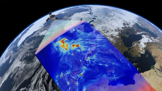
The first Copernicus satellite dedicated to monitoring air pollution is set to launch in October. Discover more about Sentinel-5P
vrchní referent/rada v oddělení obnovy katastrálního operátu technického útvaru (03010)
30.8.2017 7:43 ČÚZK - volná místa Katastrální úřad pro Královéhradecký kraj vypisuje výběrové řízení na místo vrchní referent/rada v oddělení obnovy katastrálního operátu technického útvaru (03010)vrchní referent/rada v oddělení obnovy katastrálního operátu technického útvaru (03010)
30.8.2017 7:43 ČÚZK - předpisy a opatření Katastrální úřad pro Královéhradecký krajvypisuje výběrové řízení na místo vrchní referent/rada v oddělení obnovy katastrálního operátu technického útvaru (03010)
vrchní referent/rada v oddělení obnovy katastrálního operátu technického útvaru (03010)
vrchní referent/rada v oddělení obnovy katastrálního operátu technického útvaru (03010)
30.8.2017 7:43 ČÚZK /Urady/Katastralni-urady/Katastralni-urady/Katastralni-urad-pro-Kralovehradecky-kraj/Uredni-deska/Oznameni-a-jina-uredni-sdeleni/Volna-mista/vrchni-referent-rada-v-oddeleni-obnovy-katastr-(1)Digitální model povrchu - stínovaný
30.8.2017 2:00 Cenia - Katalog metadat ČR - INSPIRE Stínovaný digitální model povrchu vznikl geoprocesingovým přepočtem z DSM. používá se pro zobrazování v mapě, kde pomocí zobrazení osvětlených a neosvětlených míst vytváří dojem plasticity reliéfu na mapědigitální model povrchu - 1m
30.8.2017 2:00 Cenia - Katalog metadat ČR - INSPIRE Digitální model povrchuvznikl vyhodnocením leteckých snímků. Zobrazuje terén včetně všech objektů na něm - budovy, mosty, porosty zeleně apod.Carlson SurvPC & SurvCE help with disaster clean-up & rebuilding
29.8.2017 22:31 Carlson Software As the destruction from Harvey continues along the Gulf Coast, those at Carlson Software watch with empathy for the staggering loss and suffering and hope for relief for all the residents in the near future. While clean-up and rebuilding may be in the future, here is some information on how Asbell Excavating in Joplin, Missouri, […]Be prepared for aged power generation infrastructures with Bentley APM solution
29.8.2017 17:06 Bentley SystemsPress Coverage
KNP News, South Korea
Read the articleSoyuzhimpromproekt Implements BIM Strategy on Russia’s First Methylchlorosilane Production Facility
29.8.2017 17:01 Bentley SystemsPress Coverage
BIM Journal, UK
Read the articleGIS v plánování měst a regionů
29.8.2017 13:50 Zeměměřič se uskuteční ve čtvrtek 14. září 2017 v Praze.V mapové aplikaci Územně pláno
29.8.2017 12:00 Jihočeský kraj V mapové aplikaci Územně plánovací dokumentace obcí byla aktualizována územně plánovací dokumentace obcí Bednáreček, Besednice, Boršov, Brloh, Cizkrajov, Dačice, Dolní Pěna, Husinec, Kačlehy, Kájov, Komárov, Netolice, Prachatice, Strunkovice nad Blanicí, Včelná a Vidov. Nově pak byla přidána územně plánovací dokumentace obcí Bílsko a Velešín.V mapové aplikaci byla aktual
29.8.2017 12:00 Jihočeský kraj V mapové aplikaci byla aktualizována územně plánovací dokumentace obcí Bednáreček, Besednice, Boršov, Brloh, Cizkrajov, Dačice, Dolní Pěna, Husinec, Kačlehy, Kájov, Komárov, Netolice, Prachatice, Strunkovice nad Blanicí, Včelná a Vidov. Nově pak byla přidána územně plánovací dokumentace obcí Bílsko a Velešín.Obnova kat. operátu v k. ú. Skalka u Blíževedel a Hvězda pod Vlhoštěm - platnost
29.8.2017 11:45 ČÚZK - předpisy a opatření Katastrální úřad pro Liberecký kraj - Katastrální pracoviště Česká Lípazveřejnil novou aktualitu: Katastrální úřad pro Liberecký kraj, Katastrální pracoviště Česká Lípa oznamuje, že dne 29. 8. 2017 byla vyhlášena platnost obnoveného katastrálního operátu přepracováním souboru geodetických informací na části katastrálního území Hvězda pod Vlhoštěm a v katastrálním území Skalka u Blíževedel obce Blíževedly. Podrobnosti viz úřední deska.
Obnova kat. operátu v k. ú. Skalka u Blíževedel a Hvězda pod Vlhoštěm - platnost
29.8.2017 11:45 ČÚZK /Urady/Katastralni-urady/Katastralni-urady/Katastralni-urad-pro-Liberecky-kraj/Katastralni-pracoviste/KP-Ceska-Lipa/O-uradu/Aktuality/Obnova-kat-operatu-v-k-u-Skalka-u-Blizevedel-aČínští a evropští kosmonauti se připravují společně
29.8.2017 10:33 Český Kosmický PortálKosmonauti ESA Samantha Cristoforettiová a Matthias Maurer se na počátku srpna přidali ke skupině šestnácti čínských astronautů během devítidenního cvičení přežití na moře u pobřežního města Jantaj. Hlavním cílem této a dalších společných aktivit je pro ESA ustanovení dlouhodobé spolupráce s Čínou a otevření možnosti letů evropských kosmonautů na čínskou kosmickou stanici.
Mapping crops
29.8.2017 9:00 ESA Observing the Earth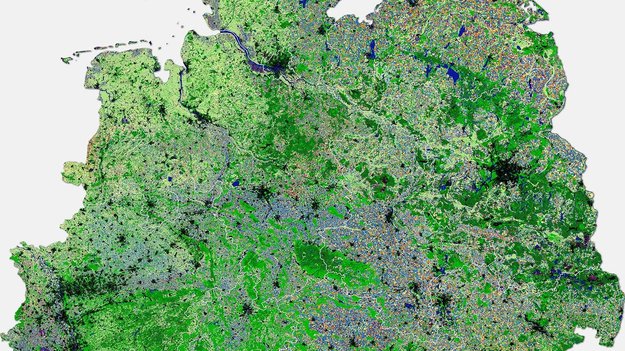
Combining images from the Copernicus Sentinel-2 and US Landsat-8 missions reveals different crops across Germany
Odborný referent/vrchní referent v oddělení aktualizace KN
29.8.2017 7:58 ČÚZK /Urady/Katastralni-urady/Katastralni-urady/Katastralni-urad-pro-Jihomoravsky-kraj/Uredni-deska/Oznameni-a-jina-uredni-sdeleni/Volna-mista/Odborny-referent-vrchni-referent-v-oddeleni-aktualOdborný referent/vrchní referent v oddělení aktualizace KN
29.8.2017 7:58 ČÚZK - volná místa Katastrální úřad pro Jihomoravský kraj - Katastrální pracoviště Vyškov vypisuje výběrové řízení na místo Odborný referent/vrchní referent v oddělení aktualizace KNOdborný referent/vrchní referent v oddělení aktualizace KN
29.8.2017 7:58 ČÚZK - předpisy a opatření Katastrální úřad pro Jihomoravský kraj - Katastrální pracoviště Vyškovvypisuje výběrové řízení na místo
Odborný referent/vrchní referent v oddělení aktualizace KN
Odborný referent v oddělení aktualizace KN
29.8.2017 7:51 ČÚZK - předpisy a opatření Katastrální úřad pro Jihomoravský kraj - Katastrální pracoviště Kyjovvypisuje výběrové řízení na místo
Odborný referent v oddělení aktualizace KN
Odborný referent v oddělení aktualizace KN
29.8.2017 7:51 ČÚZK /Urady/Katastralni-urady/Katastralni-urady/Katastralni-urad-pro-Jihomoravsky-kraj/Uredni-deska/Oznameni-a-jina-uredni-sdeleni/Volna-mista/Odborny-referent-v-oddeleni-aktualizace-KNOdborný referent v oddělení aktualizace KN
29.8.2017 7:51 ČÚZK - volná místa Katastrální úřad pro Jihomoravský kraj - Katastrální pracoviště Kyjov vypisuje výběrové řízení na místo Odborný referent v oddělení aktualizace KNAqua+ Increases Plant Control System Design Speed by 50 Percent
29.8.2017 2:00 Bentley SystemsPress Coverage
BIM Journal, UK
Read the articleCloud-free view
28.8.2017 14:45 ESA Observing the Earth
Automatically stitching together multiple images from Sentinel-2, Austrian company EOX gives us an unobstructed view of Earth
Izraelský Bio-Nexus kupuje českou firmu Cleerio (Geosense)
28.8.2017 13:03 GeoBusinessDvě společnosti ze svého portfolia se rozhodl spojit venture kapitálový fond Springtide Ventures, který patří do skupiny KKCG. Izraelská společnost Bio-Nexus na základě tohoto rozhodnutí zakoupí českou technologickou firmu Cleerio.…
The post Izraelský Bio-Nexus kupuje českou firmu Cleerio (Geosense) appeared first on GeoBusiness.
Managing water
28.8.2017 10:30 ESA Observing the Earth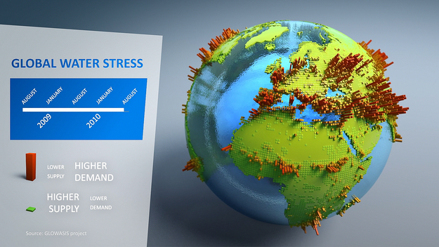
As international experts convene in Stockholm for World Water Week, discover how satellites help to manage this precious resource for irrigation
Inspektor Zeměměřického a katastrálního inspektorátu v Brně (obor služby 70.)
28.8.2017 8:35 ČÚZK - předpisy a opatření Zeměměřický a katastrální inspektorát v Brněvypisuje výběrové řízení na místo
Inspektor Zeměměřického a katastrálního inspektorátu v Brně (obor služby 70.)
Inspektor Zeměměřického a katastrálního inspektorátu v Brně (obor služby 70.)
28.8.2017 8:35 ČÚZK /Urady/Zememericke-a-katastralni-inspektoraty/Zememericke-a-katastralni-inspektoraty/Zememericky-a-katastralni-inspektorat-v-Brne/Uredni-deska/Oznameni-a-jina-uredni-sdeleni/Volna-mista/Inspektor-Zememerickeho-a-katastralniho-inspektoraInspektor Zeměměřického a katastrálního inspektorátu v Brně (obor služby 70.)
28.8.2017 8:35 ČÚZK - volná místa Zeměměřický a katastrální inspektorát v Brně vypisuje výběrové řízení na místo Inspektor Zeměměřického a katastrálního inspektorátu v Brně (obor služby 70.)Oznámení o vyhlášení výběrového řízení na služební místo odborný rada oddělení řízení pozemkových úprav, odbor metodiky pozemkových úprav
28.8.2017 0:00 Státní pozemkový úřad Ústřední ředitelka Státního pozemkového úřadu, jako služební orgán příslušný podle § 10 odst. 1 písm. f) zákona č. 234/2014 Sb., o státní službě (dále jen „zákon“), vyhlašuje výběrové řízení na služební místo odborný rada oddělení řízení pozemkových úprav, odbor metodiky pozemkových úprav.Oznámení o vyhlášení výběrového řízení na služební místo odborný rada oddělení řízení krajských pozemkových úřadů
28.8.2017 0:00 Státní pozemkový úřad Ústřední ředitelka Státního pozemkového úřadu, jako služební orgán příslušný podle § 10 odst. 1 písm. f) zákona č. 234/2014 Sb., o státní službě (dále jen „zákon“), vyhlašuje výběrové řízení na služební místo odborný rada oddělení řízení krajských pozemkových úřadů.Nabídka práce na Ministerstvu zemědělství
26.8.2017 22:02 GISportal.cz Nabídka práce v Praze, MZe hledá GISáka.Watching Harvey
25.8.2017 15:55 ESA Observing the Earth
Sentinel-3A takes Hurricane Harvey’s temperature as the storm gains strength and moves towards Texas
odborný referent – obnova katastrálního operátu
25.8.2017 12:25 ČÚZK - volná místa Katastrální úřad pro Olomoucký kraj - Katastrální pracoviště Šumperk vypisuje výběrové řízení na místo odborný referent – obnova katastrálního operátuodborný referent – obnova katastrálního operátu
25.8.2017 12:25 ČÚZK - předpisy a opatření Katastrální úřad pro Olomoucký kraj - Katastrální pracoviště Šumperkvypisuje výběrové řízení na místo
odborný referent – obnova katastrálního operátu
odborný referent – obnova katastrálního operátu
25.8.2017 12:25 ČÚZK /Urady/Katastralni-urady/Katastralni-urady/Katastralni-urad-pro-Olomoucky-kraj/Uredni-deska/Oznameni-a-jina-uredni-sdeleni/Volna-mista/odborny-referent-–-obnova-katastralniho-operatu-(1vrchní referent/rada – vedení katastrální mapy
25.8.2017 12:20 ČÚZK - volná místa Katastrální úřad pro Olomoucký kraj - Katastrální pracoviště Šumperk vypisuje výběrové řízení na místo vrchní referent/rada – vedení katastrální mapyvrchní referent/rada – vedení katastrální mapy
25.8.2017 12:20 ČÚZK - předpisy a opatření Katastrální úřad pro Olomoucký kraj - Katastrální pracoviště Šumperkvypisuje výběrové řízení na místo
vrchní referent/rada – vedení katastrální mapy
vrchní referent/rada – vedení katastrální mapy
25.8.2017 12:20 ČÚZK /Urady/Katastralni-urady/Katastralni-urady/Katastralni-urad-pro-Olomoucky-kraj/Uredni-deska/Oznameni-a-jina-uredni-sdeleni/Volna-mista/vrchni-referent-rada-–-vedeni-katastralni-mapy2. národní workshop projektu ATTRACTIVE DANUBE zaměřený na dostupnost dat pro indikátory atraktivity
25.8.2017 9:01 CENIA - národní geoportál INSPIRE CENIA, česká informační agentura životního prostředí si Vás dovoluje pozvat na 2. národní workshop projektu ATTRACTIVE DANUBE, zaměřený na téma dostupnost dat pro indikátory atraktivity. Workshop proběhne ve čtvrtek 21. září 2017 od 10:00 do 14:00 v prostorách Evropského domu (Jungmannova 745/24, Praha 1). V červnu letošního roku CENIA zorganizovala první ze tří plánovaných workshopů, věnovaných...Přerušení dodávky elektřiny
24.8.2017 22:07 ČÚZK - předpisy a opatření Katastrální úřad pro Královéhradecký kraj - Katastrální pracoviště Trutnov zveřejnil novou aktualitu: Z důvodu přerušení dodávky elektřiny ve čtvrtek dne 31. 8. 2017 v důsledku provádění plánovaných prací na zařízení distribuční soustavy ČEZ dojde v době od 7:30 do 10:30 hodin k omezení provozu Katastrálního pracoviště Trutnov. Provoz by měl být v plném rozsahu obnoven ještě téhož dne v pozdějších hodinách.Za způsobené problémy se uživatelům služeb katastru nemovitostí omlouváme.
Přerušení dodávky elektřiny
24.8.2017 22:07 ČÚZK /Urady/Katastralni-urady/Katastralni-urady/Katastralni-urad-pro-Kralovehradecky-kraj/Katastralni-pracoviste/KP-Trutnov/O-uradu/Aktuality/Preruseni-dodavky-elektrinyEmbracing BIM for Capital Project Delivery
24.8.2017 20:08 Bentley SystemsPress Coverage
EE Publishers, South Africa
Read the articlePrvní státní hackathon pod taktovkou NKÚ
24.8.2017 16:18 GeoBusinessRoční provoz e-governmentu vyjde na 25 miliard korun. Národní kontrolní úřad proto vyhlásil první státní hackathon, aby v něm „externisté“ ukázali, jak by se s daty dalo lépe pracovat. Na…
The post První státní hackathon pod taktovkou NKÚ appeared first on GeoBusiness.
24.8.2017
24.8.2017 12:45Realizovali jsme Kalendář akcí, více se dozvíte na následujících odkazech akcezde.cz a zde.
Vytvářeli jsme pro Řízení letového provozu unikátní pohledy u věže Letiště Praha
24.8.2017 11:53 UpVision Vytvářeli jsme pro Řízení letového provozu unikátní panoramatické pohledy vedle věže u Letiště Praha, vše s potřebnými povoleními a zvláštní koordinací Letiště a ŘLP.Zde náhled na řídící věž:
https://plus.google.com/u/0/b/115833877689730865211/+UpvisionCz1/posts/hrb7ELse6c3
Přehled: Software pro podporu správy majetku a facility management
24.8.2017 11:24 GeoBusinessFacility management software se používá jako informační podpora při komplexních řešeních správy budov a majetku. Přinášíme představení čtyř firem, které řešení pro FM poskytují. Správa majetku na mapě (Cleerio) Online…
The post Přehled: Software pro podporu správy majetku a facility management appeared first on GeoBusiness.
Opportunities abound in Taiwan
24.8.2017 10:31 European GNSS Agency
In recent years, Taiwan has emerged as a world-leading GNSS receiver and chipset manufacturer. In fact, Taiwan-based Mediatek is now positioned as one of the top 3 mobile chipset manufacturers and the country is also home to leading OEMs for LBS and automotive navigation equipment.
The GSA-funded GNSS.asia project is dedicated to developing and implementing GNSS industrial cooperation between European and Asia-Pacific GNSS industries, with a focus on the downstream market and has been actively working with Taiwanese stakeholders, including Mediatek.
“GNSS.asia in Taiwan has built a good network with key Taiwanese counterparts from both the public and private sectors,” says European Chamber of Commerce in Taiwan EU Programme & Technology Committee Assistant Director Angela Hsiao. “Our team has significant knowledge about the international and national policy frameworks relevant to industrial cooperation and high-tech businesses.” According to Hsiao, GNSS.asia is working closely with the governmental agencies under Taiwan’s Ministry of Transportation and Communications (MOTC) and Ministry of Economic Affairs (MOEA), as well as key industrial associations and research institutions operating in various GNSS fields.
Multiple opportunities
Unlike its neighbouring countries, Taiwan is not developing its own GNSS system. Instead, it has positioned itself as an ideal testbed for multi-GNSS applications and services. “The size of Taiwan’s population, the plethora of tall buildings in Taipei and the variety of geographical characteristics of the island provide diverse challenges for GNSS applications to innovate solutions to,” explains Hsiao. “Key technologies, including smart transportation, telematics, autonomous driving, disaster prevention and search and rescue, all of which require GNSS applications, are being developed here in Taiwan.”
Clearly, multi-GNSS is an essential opportunity that Taiwan wants to pursue. “Taiwan, which has a limited domestic market, has done an excellent job at positioning itself in the global high-tech industry,” says Hsiao. “As a result, it is now home to some of the largest chip manufacturers and semiconductor board integrators.”
Other areas of interest to both Taiwan and the EU are car communications, the Internet of Things (IoT) and sensor fusion. “In Taiwan, the shift from a focus on computers to mobile devices has resulted in a steady decline in computer and related industries, such as display, power and memory,” says Hsiao. “However, the advance of digitisation is bringing new opportunities that are re-inventing the landscape of information technology.”
Hsiao notes that although this transition will take time, progress is already being seen in the IoT, car communications and robotics sectors. “The evolution has in any case started and has been made possible by the availability of sensors in large volumes at low cost, by the continuous progress of Taiwan’s connectivity and by the power of computation that is brought about by faster and lower power micro-controllers,” she says.
An ICT powerhouse
In just 30 years, Taiwan has become a strategic player in the design, testing and manufacturing of ICT products. This achievement was made possible because of a successful combination of public and private commitment to ensuring a high level of R&D spending, the strong entrepreneurial drive of Taiwanese businesspeople and an innovative business and industrial ecosystem.
As a result, today ICT is another important field for R&D cooperation between European and Taiwanese entities, with many new areas of cooperation quickly emerging. For example, since the micro- and nano-electronics sectors were identified as major fields of joint interest in 2015, a series of novel and disruptive technologies aiming to address new applications and market segments (such as ICT for healthcare and robotics) have emerged. “Major trends such as IoT and Wearable Technologies are also driving innovation worldwide, and should be considered as major triggers to mobilise all players in Taiwan, both from the public and private sectors, to look for collaboration with Europe,” says Hsiao.
Keeping the momentum going
Looking ahead, Hsiao sees car communications, IoT, autonomous driving, disaster prevention, search and rescue and healthcare services as the key future trends in the Taiwan market where GNSS applications can play an important role. “Future GNSS.asia activities in Taiwan will keep the momentum going, gathering key partners from the public and private sectors to share best practices on innovating GNSS applications,” she says. “As this happens, the GNSS.asia Taiwan team will continue to support industrial relations between the EU and Taiwan and facilitate EGNSS breakthroughs via effective and efficient communication.”
Media note: This feature can be republished without charge provided the European GNSS Agency (GSA) is acknowledged as the source at the top or the bottom of the story. You must request permission before you use any of the photographs on the site. If you republish, we would be grateful if you could link back to the GSA website (http://www.gsa.europa.eu).
Jak je každá z družic Galileo před startem testována
24.8.2017 8:14 Český Kosmický PortálKaždá družice Galileo musí před cestou do vesmíru projít náročnou testovací kampaní, která zajistí její připravenost na start, vakuum a teplotní extrémy na oběžné dráze Země.
Jak je každá z družic Galileo před startem testována
24.8.2017 8:14 Český Kosmický PortálKaždá družice Galileo musí před cestou do vesmíru projít náročnou testovací kampaní, která zajistí její připravenost na start, vakuum a teplotní extrémy na oběžné dráze Země.
Státní pozemkový úřad na agrosalonu Země živitelka
24.8.2017 0:00 Státní pozemkový úřad Ve dnech 24. až 29. srpna 2017 se Státní pozemkový úřad prezentuje na mezinárodním agrosalonu Země živitelka v Českých Budějovicích.Oznámení o přerušení provozu Pobočky Frýdek-Místek
24.8.2017 0:00 Státní pozemkový úřad Z důvodu přerušení dodávky vody (havárie na vodovodní síti) bude v pátek 25. 8. 2017 přerušen provoz na Pobočce Frýdek-Místek (KPÚ pro Moravskoslezský kraj).Design and Analysis Software Adapted for Offshore US Wind Farm Engineering
23.8.2017 19:56 Bentley SystemsPress Coverage
Offshore Oil & Gas Magazine, USA
Read the articleChange Leader: Overcoming Budget Constraints at State DOTs
23.8.2017 19:51 Bentley SystemsPress Coverage
AEC Magazine
Read the articleRobin Partington & Partners Implements Federated BIM Workflow to Design Westminster Borough's Iconic Tower
23.8.2017 17:55 Bentley SystemsPress Coverage
MicroStation Connections, USA
Read the articleRobin Partington & Partners Implements Federated BIM Workflow to Design Westminster Borough's Iconic Tower
23.8.2017 17:55 Bentley SystemsPress Coverage
MicroStation Connections, USA
Read the article20170823 - volné místo - Odborný referent v OD KP Litoměřice
23.8.2017 14:20 ČÚZK /Urady/Katastralni-urady/Katastralni-urady/Katastralni-urad-pro-Ustecky-kraj/O-uradu/Aktuality/20170816-volne-misto-Odborny-referent-v-OAaD-K-(3)20170823 - volné místo - Odborný referent v OD KP Litoměřice
23.8.2017 14:20 ČÚZK - předpisy a opatření Katastrální úřad pro Ústecký kraj - Katastrální pracoviště Litoměřice zveřejnil novou aktualitu: Nabídka volného pracovního místa - Odborný referent v oddělení dokumentace KN Katastrálního pracoviště Litoměřice na Katastrálním úřadu pro Ústecký kraj20170823 - volné místo - Odborný rada-právník v OPV KP Rumburk
23.8.2017 14:16 ČÚZK /Urady/Katastralni-urady/Katastralni-urady/Katastralni-urad-pro-Ustecky-kraj/O-uradu/Aktuality/20170816-volne-misto-Odborny-referent-v-OAaD-K-(2)20170823 - volné místo - Odborný rada-právník v OPV KP Rumburk
23.8.2017 14:16 ČÚZK - předpisy a opatření Katastrální úřad pro Ústecký kraj - Katastrální pracoviště Rumburk zveřejnil novou aktualitu: Nabídka volného pracovního místa - Odborný rada - právník v oddělení právních vztahů k nemovitostem Katastrálního pracoviště Rumburk na Katastrálním úřadu pro Ústecký kraj20170823 - volné místo - Odborný rada v OAaD KP Rumburk
23.8.2017 14:12 ČÚZK - předpisy a opatření Katastrální úřad pro Ústecký kraj - Katastrální pracoviště Rumburk zveřejnil novou aktualitu: Nabídka volného pracovního místa - Odborný rada v oddělení aktualizace a dokumentace KN Katastrálního pracoviště Rumburk na Katastrálním úřadu pro Ústecký kraj20170823 - volné místo - Odborný rada v OAaD KP Rumburk
23.8.2017 14:12 ČÚZK /Urady/Katastralni-urady/Katastralni-urady/Katastralni-urad-pro-Ustecky-kraj/O-uradu/Aktuality/20170816-volne-misto-Odborny-referent-v-OAaD-K-(1)Odborný referent v oddělení dokumentace KN Katastrálního pracoviště Litoměřice na Katastrálním úřadu
23.8.2017 14:10 ČÚZK - volná místa Katastrální úřad pro Ústecký kraj - Katastrální pracoviště Litoměřice vypisuje výběrové řízení na místo Odborný referent v oddělení dokumentace KN Katastrálního pracoviště Litoměřice na Katastrálním úřaduOdborný referent v oddělení dokumentace KN Katastrálního pracoviště Litoměřice na Katastrálním úřadu
23.8.2017 14:10 ČÚZK - předpisy a opatření Katastrální úřad pro Ústecký kraj - Katastrální pracoviště Litoměřicevypisuje výběrové řízení na místo
Odborný referent v oddělení dokumentace KN Katastrálního pracoviště Litoměřice na Katastrálním úřadu pro Ústecký kraj
Odborný rada - právník v oddělení právních vztahů k nemovitostem Katastrálního pracoviště Rumburk n
23.8.2017 14:06 ČÚZK /Urady/Katastralni-urady/Katastralni-urady/Katastralni-urad-pro-Ustecky-kraj/Uredni-deska/Oznameni-a-jina-uredni-sdeleni/Volna-mista/Odborny-rada-pravnik-v-oddeleni-pravnich-vztahuOdborný rada - právník v oddělení právních vztahů k nemovitostem Katastrálního pracoviště Rumburk n
23.8.2017 14:06 ČÚZK - předpisy a opatření Katastrální úřad pro Ústecký kraj - Katastrální pracoviště Rumburkvypisuje výběrové řízení na místo
Odborný rada - právník v oddělení právních vztahů k nemovitostem Katastrálního pracoviště Rumburk na Katastrálním úřadu pro Ústecký kraj
Odborný rada - právník v oddělení právních vztahů k nemovitostem Katastrálního pracoviště Rumburk n
23.8.2017 14:06 ČÚZK - volná místa Katastrální úřad pro Ústecký kraj - Katastrální pracoviště Rumburk vypisuje výběrové řízení na místo Odborný rada - právník v oddělení právních vztahů k nemovitostem Katastrálního pracoviště Rumburk nOdborný rada v oddělení aktualizace a dokumentace KN Katastrálního pracoviště Rumburk na Katastrální
23.8.2017 13:58 ČÚZK - volná místa Katastrální úřad pro Ústecký kraj - Katastrální pracoviště Rumburk vypisuje výběrové řízení na místo Odborný rada v oddělení aktualizace a dokumentace KN Katastrálního pracoviště Rumburk na KatastrálníOdborný rada v oddělení aktualizace a dokumentace KN Katastrálního pracoviště Rumburk na Katastrální
23.8.2017 13:58 ČÚZK - předpisy a opatření Katastrální úřad pro Ústecký kraj - Katastrální pracoviště Rumburkvypisuje výběrové řízení na místo
Odborný rada v oddělení aktualizace a dokumentace KN Katastrálního pracoviště Rumburk na Katastrálním úřadu pro Ústecký kraj
Odborný rada v oddělení aktualizace a dokumentace KN Katastrálního pracoviště Rumburk na Katastrální
23.8.2017 13:58 ČÚZK /Urady/Katastralni-urady/Katastralni-urady/Katastralni-urad-pro-Ustecky-kraj/Uredni-deska/Oznameni-a-jina-uredni-sdeleni/Volna-mista/Odborny-rada-v-oddeleni-aktualizace-a-dokumentaceASOCIACE PODNIKATELŮ V GEOMATICE
23.8.2017 13:08 Komora geodetů a kartografů ČR ASOCIACE PODNIKATELŮ V GEOMATICE (APG) Komora geodetů kartografů, od 24. listopadu 2016 nesoucí název Česká komora zeměměřičů, usilující od svého vzniku v roce 1991 stát se komorou ze zákona s povinným členstvím pro všechny úředně oprávněné zeměměřické inženýry se po třetím nezdařeném pokusu dosáhnout svého cíle – tentokrát novelou stávajícího zákona 360/1992, kterým vznikla Česká komora autorizovaných architektů […]Burn scars
23.8.2017 12:00 ESA Observing the Earth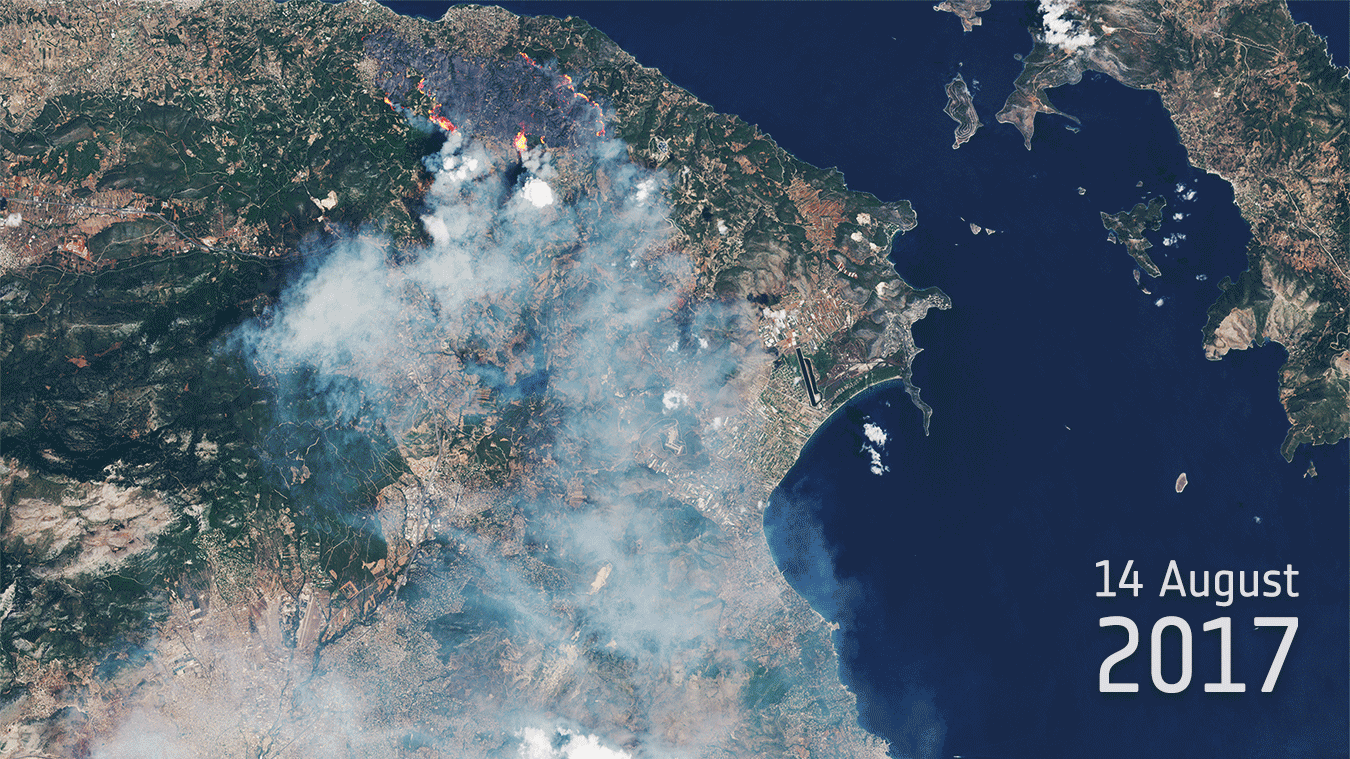
Sentinel-2 shows blazes and dramatic burn scars from wildfires in Greece
V Geoportálu ÚAP Ústeckého kra
23.8.2017 12:00 Ústecký kraj V Geoportálu ÚAP Ústeckého kraje byla provedena aktualizace údajů pro poskytovatele AOPK – jev 27, 28, 29, 31, 32 (NPR včetně OP, PR včetně OP, zákonná OP MZCHU, památné stromy)Mapová aplikace a mapová apli
23.8.2017 12:00 Jihočeský kraj Mapová aplikace a mapová aplikace byly aktualizovány k 22.8.2017.Mapová aplikace Technická infr
23.8.2017 12:00 Jihočeský kraj Mapová aplikace Technická infrastruktura a mapová aplikace Zastavěné území byly aktualizovány k 22.8.2017.20170823 Odborný referent/vrchní referent oddělení obnovy a revize katastru nemovitostí
23.8.2017 9:57 ČÚZK /Urady/Katastralni-urady/Katastralni-urady/Katastralni-urad-pro-Stredocesky-kraj/Katastralni-pracoviste/KP-Praha-zapad/O-uradu/Aktuality/20161013Rada-odborny-rada-–-informatik-(4)20170823 Odborný referent/vrchní referent oddělení obnovy a revize katastru nemovitostí
23.8.2017 9:57 ČÚZK - předpisy a opatření Katastrální úřad pro Středočeský kraj - Katastrální pracoviště Praha-západ Vyhlášení výběrového řízení: Odborný referent/vrchní referent oddělení obnovy a revize katastru nem. V části "Úřední deska", v sekci "Oznámení a jiná úřední sdělení" bylo vystaveno "Oznámení o vyhlášení výběrového řízení na obsazení systemizovaného místa Odborný referent/vrchní referent oddělení obnovy a revize katastru nemovitostí"Odborný referent/vrchní referent oddělení obnovy a revize katastru nemovitostí
23.8.2017 9:50 ČÚZK /Urady/Katastralni-urady/Katastralni-urady/Katastralni-urad-pro-Stredocesky-kraj/Uredni-deska/Oznameni-a-jina-uredni-sdeleni/Volna-mista/Odborny-referent-vrchni-referent-oddeleni-obnovy-aOdborný referent/vrchní referent oddělení obnovy a revize katastru nemovitostí
23.8.2017 9:50 ČÚZK - volná místa Katastrální úřad pro Středočeský kraj - Katastrální pracoviště Praha-západ vypisuje výběrové řízení na místo Odborný referent/vrchní referent oddělení obnovy a revize katastru nemovitostíOdborný referent/vrchní referent oddělení obnovy a revize katastru nemovitostí
23.8.2017 9:50 ČÚZK - předpisy a opatření Katastrální úřad pro Středočeský kraj - Katastrální pracoviště Praha-západvypisuje výběrové řízení na místo Odborný referent/vrchní referent oddělení obnovy a revize katastru
Odborný referent/vrchní referent oddělení obnovy a revize katastru nemovitostí
Nová nabídka práce v Brně/Praze
23.8.2017 9:24 GISportal.cz CEDA hledá programátora a architekta mapových aplikací.Letní škola GIS v Olomouci
23.8.2017 7:42 GeoBusinessV létě většina studentů odpočívá, cestuje nebo pracuje. Pro zvídavé je určena týdenní škola GISu, kterou v červenci pořádala katedra geoinformatiky na Univerzitě Palackého v Olomouci společně s dalšími zahraničními…
The post Letní škola GIS v Olomouci appeared first on GeoBusiness.
CEDA hledá Google Maps Developera
23.8.2017 7:00 Česká asociace pro geoinformaceProgramátor a Google Maps Developer
Programátor a architekt mapových aplikací, certifikovaný Google Maps Developer
CEDA jako autorizovaný Google Maps Reseller pro oblast střední a východní Evropy hledá kolegu, jenž bude zastávat také roli certifikovaného Google Maps Developera pro podporu návrhu zákaznických projektů, samostatný návrh a vývoj aplikací s Google Maps
Linky MHD dnes
23.8.2017 2:00 Cenia - Katalog metadat ČR - INSPIRE Linky a zastávky MHD provozované dnes v hl. m. PrazeMise ESA Proba-3 vytvoří umělé zatmění Slunce
22.8.2017 20:58 Český Kosmický PortálV polovině srpna společně sledovali astrofyzikové a příležitostní pozorovatelé totální zatmění Slunce nad Severní Amerikou. Zatmění trvalo řádově jen minuty, ale už v příští dekádě budou mít vědci možnost sledovat zatmění trvající hodiny. A to díky průkopnické misi ESA.
Program konference Hexagonu v září 2017 ve Valči
22.8.2017 17:19 GeoBusinessKaždoroční konference firmy Hexagon, známé původně jako Intergraph, se letos bude konat v září v nádherném prostředí hotel-zámku Valeč. 18. ročník uživatelské konference HxGN LOCAL GEOFORUM CS 2017 bude letos…
The post Program konference Hexagonu v září 2017 ve Valči appeared first on GeoBusiness.
Dodatečné výběrové řízení Erasmus+
22.8.2017 16:33 Katedra geografie UP Olomouc Katedra geografie vyhlašuje na středu 4. října 2017 dodatečné výběrové řízení na studentské mobility v rámci programu Erasmus+ na letní semestr akademického roku 2017/18. Výběrové řízení se bude konat v hlavní budově Přírodovědecké fakulty (17. listopadu 12) na učebně 2.025 v 10.00. Podrobnosti k přihlášce naleznete v prostředí aplikace erasmusplus.upol.cz (přihlášení jako do STAGu), v případě dotazů kontaktujte dr. Šimáčka. Kromě již tradičních destinací jsou v nabídce také Srbsko nebo Izrael, pro které jsou i výhodnější finanční podmínky. Uzávěrka možnosti podat přihlášku je 3. října 2017, tak svou šanci nepropásněte.Pokud žádná země z nabídky Katedry geografie nevyhovuje vašim představám, je možné se přihlásit na výběrová řízení jiných kateder, případně prostudovat možnosti mobilit na stránkách Zahraničního oddělení UP. Mobility mimo program Erasmus+ najdete v menu Výměnné programy.
Vědecká výzva IBER 2017
22.8.2017 14:48 Česká kosmická kancelář
Evropská kosmická agentura vyhlásila výzvu IBER na návrh experimentů sledujících dopad kosmického záření na živé organismy. Pochopení této problematiky je jedním z hlavních úkolů přípravy dlouhodobých pilotovaných misí mimo nízkou oběžnou dráhu kolem Země. Projektové záměry je nutné odevzdat do 27. října 2017.
Vrchní referent/rada v oddělení právních vztahů k nemovitostem
22.8.2017 14:07 ČÚZK /Urady/Katastralni-urady/Katastralni-urady/Katastralni-urad-pro-Jihomoravsky-kraj/Uredni-deska/Oznameni-a-jina-uredni-sdeleni/Volna-mista/Vrchni-referent-rada-v-oddeleni-pravnich-vztah-(1)Vrchní referent/rada v oddělení právních vztahů k nemovitostem
22.8.2017 14:07 ČÚZK - volná místa Katastrální úřad pro Jihomoravský kraj - Katastrální pracoviště Vyškov vypisuje výběrové řízení na místo Vrchní referent/rada v oddělení právních vztahů k nemovitostemVrchní referent/rada v oddělení právních vztahů k nemovitostem
22.8.2017 14:07 ČÚZK - předpisy a opatření Katastrální úřad pro Jihomoravský kraj - Katastrální pracoviště Vyškovvypisuje výběrové řízení na místo
Vrchní referent/rada v oddělení právních vztahů k nemovitostem
Hledáme nového kolegu na pozici Programátor a architekt mapových aplikací, certifikovaný Google Maps Developer
22.8.2017 13:35 CEDA Maps a.s. CEDA jako autorizovaný Google Maps Reseller pro oblast střední a východní Evropy hledá kolegu, jenž bude zastávat také roli certifikovaného Google Maps Developera pro podporu návrhu zákaznických projektů, samostatný návrh a vývoj aplikací s Google Maps API, Google Cloud Platform a dalšími mapovými a cloudovými službami.ESA otevře element InCubed pro podávání inovativních návrhů v oblasti EO
22.8.2017 13:34 Český Kosmický PortálAktualizace: živý přenos proběhne dne 6. září 2017 od 10:30 (CET), stream bude dostupný na adrese https://livestream.com/ESA/incubed
Dne 6. září 2017 se otevře výzva na předkládání návrhů projektů do elementu InCubed v programu Evropské kosmické agentury (ESA) Earth Watch, do něhož ČR vložila na ministerské radě ESA 2016 částku 1,5 MEUR. Cílem elementu je podpořit inovativní řešení s vysokým potenciálem komerčního uplatnění v oblasti pozorování Země. Do výzvy bude možné předložit projekty směřující jak k přípravě inovativních aplikací, tak i technologických řešení z oblasti pozorování Země. Element cílí především na firmy, avšak součástí konsorcia mohou být i akademické subjekty.
Podrobnosti výzvy budou následně vyvěšeny v tendrovém systému ESA EMITS.
ESA otevře element InCubed pro podávání inovativních návrhů v oblasti EO
22.8.2017 13:34 Český Kosmický PortálZáznam z otevření elementu InCubed je dostupný na adrese https://livestream.com/ESA/incubed
Dne 6. září 2017 se otevře výzva na předkládání návrhů projektů do elementu InCubed v programu Evropské kosmické agentury (ESA) Earth Watch, do něhož ČR vložila na ministerské radě ESA 2016 částku 1,5 MEUR. Cílem elementu je podpořit inovativní řešení s vysokým potenciálem komerčního uplatnění v oblasti pozorování Země. Do výzvy bude možné předložit projekty směřující jak k přípravě inovativních aplikací, tak i technologických řešení z oblasti pozorování Země. Element cílí především na firmy, avšak součástí konsorcia mohou být i akademické subjekty.
Podrobnosti výzvy budou následně vyvěšeny v tendrovém systému ESA EMITS.
ESA otevře element InCubed pro podávání inovativních návrhů v oblasti EO
22.8.2017 13:34 Český Kosmický PortálDne 6. září 2017 se otevře výzva na předkládání návrhů projektů do elementu InCubed v programu Evropské kosmické agentury (ESA) Earth Watch, do něhož ČR vložila na ministerské radě ESA 2016 částku 1,5 MEUR. Cílem elementu je podpořit inovativní řešení s vysokým potenciálem komerčního uplatnění v oblasti pozorování Země. Do výzvy bude možné předložit projekty směřující jak k přípravě inovativních aplikací, tak i technologických řešení z oblasti pozorování Země. Element cílí především na firmy, avšak součástí konsorcia mohou být i akademické subjekty.
Podrobnosti výzvy budou následně vyvěšeny v tendrovém systému ESA EMITS.