


![]()

zprávy
zdroje zpráv:Carlson 2018 Includes IntelliCAD 8.3 Built-In
13.9.2017 5:47 Carlson Software Carlson 2018 office software released in August includes IntelliCAD 8.3 built-in as well as supporting AutoCAD® 2018 which is sold separately. The built-in IntelliCAD gives customers the choice to run Carlson 2018 with no extra CAD platform cost. The Carlson 2018 programs are Survey, Civil, Hydrology, Mining, GIS, Point Cloud, Field, Natural Regrade, Construction, GeoTech, […]Výuka dr. Martináta (GEZM, SEGZ)
13.9.2017 4:52 Katedra geografie UP Olomouc Výuka předmětů KGG/GEZM Geografie zemědělství a KGG/SEGZ Seminář z geografie zemědělství bude zahájena v druhém týdnu semestru, tedy od 26. 9. 2017.Množství vody ve sněhu
13.9.2017 2:00 Cenia - Katalog metadat ČR - INSPIRE Vyhodnocení sněhových zásob se provádí zejména pro potřeby ochrany před povodněmi a hospodaření s vodou. Vyhodnocují se aktuální zásoby vody pro celou ČR, jednotlivé kraje, výšková pásma a pro vybraná povodí a vodní díla. Dále se porovnávají aktuální zásoby vody ve sněhové pokrývce s ostatními zimními sezónami od roku 1970 (s maximálními, průměrnými a minimálními objemy zásob v konkrétním týdnu sezóny).Využívají se data ze 460 operativních klimatologických a srážkoměrných stanic (z celkového počtu 835 stanic), ve kterých se měří výška sněhu denně a vodní hodnota 1x týdně. Dále se využívají data ze 16 stanic - automatických sněhoměrných polštářů, které měří změny charakteristik v desetiminutovém kroku, jsou umístěny ve všech významných vrchovinných a horských oblastech v nadmořské výšce 650 až 1062 m n. m. Dalším zdrojem dat jsou experimentální profilová měření, která se uskutečňují pravidelně na 60 vybraných lokalitách a příležitostně v problematických regionech nebo v období maxim a intenzivního tání sněhu.Oznámení o částečném omezení provozu Pobočky Nymburk
13.9.2017 0:00 Státní pozemkový úřad Z důvodu přerušení dodávky elektřiny bude v pondělí 25. 9. 2017 od 9:30 do 15:30 hod. částečně omezen provoz Pobočky Nymburk (KPÚ pro Středočeský kraj a hl. m. Praha).Hry o trůny & GIS
12.9.2017 21:53 Blogující geomatici - FAV ZČU Zajímavý tutoriál k gvSIG Desktop inspirovaný seriálem Hry o trůny:https://blog.gvsig.org/2017/07/12/learning-gis-with-game-of-thrones-free-book/
Možná by stálo za to udělat podobný tutoriál inspirovaný seriálem Okresní přebor a zkusit zjistit, jestli ty Psojedy na té mapě skutečně nejsou... ;)
Rada/odborný rada vedoucí personálního oddělení na Kanceláři ředitele katastrálního úřadu
12.9.2017 15:01 ČÚZK - volná místa Katastrální úřad pro Jihomoravský kraj vypisuje výběrové řízení na místo Rada/odborný rada vedoucí personálního oddělení na Kanceláři ředitele katastrálního úřaduRada/odborný rada vedoucí personálního oddělení na Kanceláři ředitele katastrálního úřadu
12.9.2017 15:01 ČÚZK - předpisy a opatření Katastrální úřad pro Jihomoravský krajnabízí služební místo
Rada/odborný rada vedoucí personálního oddělení na Kanceláři ředitele katastrálního úřadu
Rada/odborný rada vedoucí personálního oddělení na Kanceláři ředitele katastrálního úřadu
12.9.2017 15:01 ČÚZK /Urady/Katastralni-urady/Katastralni-urady/Katastralni-urad-pro-Jihomoravsky-kraj/Volna-mista/rada-odborny-rada-vedouci-personalniho-oddeleni-nNáplast (pro) zdraví
12.9.2017 13:47 Český Kosmický PortálBěhem šestiměsíčního pobytu kosmonauta ESA Thomase Pesqueta na Mezinárodní kosmické stanici byl jeho zdravotní stav sledovaný velmi pečlivě. Jak to ostatně dělá ESA v případě všech svých kosmonautů.
Náplast (pro) zdraví
12.9.2017 13:47 Český Kosmický PortálBěhem šestiměsíčního pobytu kosmonauta ESA Thomase Pesqueta na Mezinárodní kosmické stanici byl jeho zdravotní stav sledovaný velmi pečlivě. Jak to ostatně dělá ESA v případě všech svých kosmonautů.
Seznamte se s hlavními řečníky konference
12.9.2017 10:34 ARCDATATermín Konference GIS Esri v ČR se pomalu blíží a na našich webových stránkách proto naleznete první informace o jejím programu, seznámíte se s hlavními řečníky a vybranými součástmi doprovodného programu.
Nezapomeňte se přihlásit včas, přihlášky posterů a internetových aplikací přijímáme jen do 22. září.
Podívejte se na program jubilejního GISfóra 2017
12.9.2017 7:00 GeoBusinessSpolečnost CAD Studio pořádá jubilejní desátý ročník konference GISfórum 2017. Konferenci GISfórum pořádá firma CAD Studio již od roku 2007, akce je určena pro výměnu zkušeností s praktickým využitím GIS…
The post Podívejte se na program jubilejního GISfóra 2017 appeared first on GeoBusiness.
Podívejte se na program jubilejního GISfóra 2017
12.9.2017 7:00 GeoBusiness Společnost CAD Studio pořádá jubilejní desátý ročník konference GISfórum 2017. Konferenci GISfórum pořádá firma CAD Studio již od roku 2007, akce je určena pro výměnu zkušeností s praktickým využitím GIS…Rainfall-runoff data
12.9.2017 2:00 Cenia - Katalog metadat ČR - INSPIRE Selected, publicly available part of data from the databases of the CHMI offered for study purposes. In hydrological part, mean daily discharges from 10 stations located on bigger rivers are accessible, starting from the beginning of measurements. Also, 3 stations observing smaller rivers in the Jizera Mts. are represented in the data set by mean daily discharges, hourly discharges, snow measurements records, daily precipitation totals starting from 2002. In climatological part, there are 3 stations with daily precipitation totals starting from 2002. The website is maintained also in Czech.Hydrogeologické rajony
12.9.2017 2:00 Cenia - Katalog metadat ČR - INSPIRE Evidence obsahuje údaje o územním vymezení a charakteristikách hydrogeologických rajonů v ČR. Údaje evidence hydrogeologických rajonů zpracovává a do informačního systému veřejné správy ukládá Výzkumný ústav vodohospodářský T. G. Masaryka, veřejná výzkumná instituce. Odborným garantem správnosti je Český hydrometeorologický ústav. Hydrogeologické rajony jsou vodním zákonem definovány jako území s obdobnými hydrogeologickými poměry, typem zvodnění a oběhem podzemní vody. Hydrogeologický rajon tvoří jeden nebo více kolektorů (kolektorem se rozumí horninová vrstva nebo souvrství hornin s dostatečnou propustností, umožňující významnou spojitou akumulaci podzemní vody nebo její proudění či odběr). Podle své pozice se hydrogeologické rajony rozdělují do svrchní vrstvy kvartérních sedimentů a coniaku, základní vrstvy a hlubinné vrstvy bazálního křídového kolektoru. Hydrogeologické rajony jsou zjednodušeně vyjádřeny plochami v těchto třech horizontálních vrstvách. Hydrogeologické rajony jsou složeny z jednoho či více útvarů podzemních vod. Hydrogeologické rajony se evidují v rozsahu údajů o jejich územní identifikaci, názvu, číselném identifikátoru pozici a názvu mezinárodní oblasti povodí, ke které příslušejí. Údaj o příslušném správci povodí je jednoznačně určen pro útvary podzemních vod, ze kterých je rajon složen. Aktuální vymezení hydrogeologických rajonů je určeno vyhláškou č. 5/2011 Sb., o vymezení hydrogeologických rajonů a útvarů podzemních vod, způsobu hodnocení stavu podzemních vod a náležitostech programů zjišťování a hodnocení stavu podzemních vod.Fotíme pro CzechTourism po ČR na místech jako Baťův kanál, Žatecké chmelnice nebo Jurkovičovy stavby
11.9.2017 21:39 UpVision Celé léto fotíme v různých koutech České republiky pro CzechTourism, pro mezinárodní kampaň Česka na příští rok k výročí založení Československa. Jeden den tak fotíme chmelnice na Žatecku, další den Jurkovičovu lávku v Novém Městě nad Metují a další den Baťův kanál. :-)Sledujte naše fotky na facebooku nebo na Google+
https://www.facebook.com/UpVision-199025016952740/
https://plus.google.com/u/0/b/115833877689730865211/+UpvisionCz1
Kartografové si zvolili nové vedení
11.9.2017 16:54 GeoBusinessČeská kartografická společnost měla 7. září 2017 během letošní kartografické konference v Liberci členskou schůzi. Kdo byl zvolen pro období 2017-2021 do nového výboru? Společnost, která se do roku 2015…
The post Kartografové si zvolili nové vedení appeared first on GeoBusiness.
Kartografové si zvolili nové vedení
11.9.2017 16:54 GeoBusiness Česká kartografická společnost měla 7. září 2017 během letošní kartografické konference v Liberci členskou schůzi. Kdo byl zvolen pro období 2017-2021 do nového výboru? Společnost, která se do roku 2015…Cleerio využívá nové technologie v komunikaci se zákazníky – Přihlaste se na webinář
11.9.2017 14:48 CleerioPřipravujeme pravidelný cyklus webinářů. Webináře jsou určeny pro všechny uživatele mapové aplikace a cílem je zefektivnit práci s mapovou aplikací.
Příspěvek Cleerio využívá nové technologie v komunikaci se zákazníky – Přihlaste se na webinář pochází z CLEERIO
Cleerio využívá nové technologie v komunikaci se zákazníky – Přihlaste se na webinář
11.9.2017 14:48 Cleerio Připravujeme pravidelný cyklus webinářů. Webináře jsou určeny pro všechny uživatele mapové aplikace a cílem je zefektivnit práci s mapovou aplikací.Cleerio využívá nové technologie v komunikaci se zákazníky – Přihlaste se na webinář
11.9.2017 14:48 CleerioPřipravujeme pravidelný cyklus webinářů. Webináře jsou určeny pro všechny uživatele mapové aplikace a cílem je zefektivnit práci s mapovou aplikací.
Příspěvek Cleerio využívá nové technologie v komunikaci se zákazníky – Přihlaste se na webinář pochází z Cleerio
Setkání starostů a místostarostů Středočeského kraje v Senohrabech
11.9.2017 14:48 Cleerio Setkání starostů a místostarostů Středočeského kraje tentokrát potěšilo velmi velkou účastí a brzkým vyprodáním všech dostupných míst. Tentokrát jsme zaujali ukázkou mobilní verze pro pohodlnou aktualizaci dat z terénu.Cleerio využívá nové technologie v komunikaci se zákazníky – Přihlaste se na webinář
11.9.2017 14:48 CleerioPřipravujeme pravidelný cyklus webinářů. Webináře jsou určeny pro všechny uživatele mapové aplikace a cílem je zefektivnit práci s mapovou aplikací.
Příspěvek Cleerio využívá nové technologie v komunikaci se zákazníky – Přihlaste se na webinář pochází z Cleerio
Cleerio využívá nové technologie v komunikaci se zákazníky – Přihlaste se na webinář
11.9.2017 14:48 CleerioPřipravujeme pravidelný cyklus webinářů. Webináře jsou určeny pro všechny uživatele mapové aplikace a cílem je zefektivnit práci s mapovou aplikací.
Příspěvek Cleerio využívá nové technologie v komunikaci se zákazníky – Přihlaste se na webinář pochází z CLEERIO
Setkání starostů a místostarostů Středočeského kraje v Senohrabech
11.9.2017 14:48 CleerioSetkání starostů a místostarostů Středočeského kraje tentokrát potěšilo velmi velkou účastí a brzkým vyprodáním všech dostupných míst. Tentokrát jsme zaujali ukázkou mobilní verze pro pohodlnou aktualizaci dat z terénu.
Příspěvek Setkání starostů a místostarostů Středočeského kraje v Senohrabech pochází z CLEERIO
Setkání starostů a místostarostů Středočeského kraje v Senohrabech
11.9.2017 14:48 CleerioSetkání starostů a místostarostů Středočeského kraje tentokrát potěšilo velmi velkou účastí a brzkým vyprodáním všech dostupných míst. Tentokrát jsme zaujali ukázkou mobilní verze pro pohodlnou aktualizaci dat z terénu.
Příspěvek Setkání starostů a místostarostů Středočeského kraje v Senohrabech pochází z Cleerio
Cleerio využívá nové technologie v komunikaci se zákazníky – Přihlaste se na webinář
11.9.2017 14:48 CleerioPřipravujeme pravidelný cyklus webinářů. Webináře jsou určeny pro všechny uživatele mapové aplikace a cílem je zefektivnit práci s mapovou aplikací.
Příspěvek Cleerio využívá nové technologie v komunikaci se zákazníky – Přihlaste se na webinář pochází z CLEERIO
Setkání starostů a místostarostů Středočeského kraje v Senohrabech
11.9.2017 14:48 CleerioSetkání starostů a místostarostů Středočeského kraje tentokrát potěšilo velmi velkou účastí a brzkým vyprodáním všech dostupných míst. Tentokrát jsme zaujali ukázkou mobilní verze pro pohodlnou aktualizaci dat z terénu.
Příspěvek Setkání starostů a místostarostů Středočeského kraje v Senohrabech pochází z CLEERIO
eng Cleerio využívá nové technologie v komunikaci se zákazníky – Přihlaste se na webinář
11.9.2017 14:48 CleerioPřipravujeme pravidelný cyklus webinářů. Webináře jsou určeny pro všechny uživatele mapové aplikace a cílem je zefektivnit práci s mapovou aplikací.
Příspěvek eng Cleerio využívá nové technologie v komunikaci se zákazníky – Přihlaste se na webinář pochází z Cleerio
Odborný referent v oddělení aktualizace KN č. 2
11.9.2017 12:14 ČÚZK - předpisy a opatření Katastrální úřad pro Jihomoravský kraj - Katastrální pracoviště Znojmovypisuje výběrové řízení na místo
Odborný referent v oddělení aktualizace KN č. 2
Odborný referent v oddělení aktualizace KN č. 2
11.9.2017 12:14 ČÚZK - volná místa Katastrální úřad pro Jihomoravský kraj - Katastrální pracoviště Znojmo vypisuje výběrové řízení na místo Odborný referent v oddělení aktualizace KN č. 2Odborný referent v oddělení aktualizace KN č. 2
11.9.2017 12:14 ČÚZK /Urady/Katastralni-urady/Katastralni-urady/Katastralni-urad-pro-Jihomoravsky-kraj/Uredni-deska/Oznameni-a-jina-uredni-sdeleni/Volna-mista/Odborny-referent-v-oddeleni-aktualizace-KN-c-2Rada/odborný rada v právním oddělení č. 1
11.9.2017 12:09 ČÚZK - volná místa Katastrální úřad pro Jihomoravský kraj - Katastrální pracoviště Brno-město vypisuje výběrové řízení na místo Rada/odborný rada v právním oddělení č. 1Rada/odborný rada v právním oddělení č. 1
11.9.2017 12:09 ČÚZK - předpisy a opatření Katastrální úřad pro Jihomoravský kraj - Katastrální pracoviště Brno-městovypisuje výběrové řízení na místo
Rada/odborný rada v právním oddělení č. 1
V seznamu mapových služeb obla
11.9.2017 12:00 Plzeňský kraj V seznamu mapových služeb oblasti Územně analytické podklady ORP byla aktualizována Základní výkresy územně analytických podkladů obcí s rozšířenou působností a Souhrnná dlaždicová mapová služba zobrazující všechny jevy ÚAP ORP.Výdej dat je již funkční. V ob
11.9.2017 12:00 Plzeňský kraj Výdej dat je již funkční. V období 11. - 15. 9. budou postupně doplněny všechny výdejní sady.V seznamu mapových služeb obla
11.9.2017 12:00 Plzeňský kraj V seznamu mapových služeb oblasti Územně analytické podklady ORP (http://geoportal.plzensky-kraj.cz/gs/uzemne-analyticke-podklady-orp/) byla aktualizována Základní výkresy územně analytických podkladů obcí s rozšířenou působností (http://mapy.kr-plzensky.cz/gis/uap_orp_vykresy) a Souhrnná dlaždicová mapová služba zobrazující všechny jevy ÚAP ORP. (http://mapy.kr-plzensky.cz/gis/uap_orp_vse_cache)Nepotřebný majetek - výběrové řízení
11.9.2017 11:41 ČÚZK /Urady/Katastralni-urady/Katastralni-urady/Katastralni-urad-pro-Liberecky-kraj/Nabidky-majetku/Nepotrebny-majetek-vyberove-rizeni-(3)Nepotřebný majetek - výběrové řízení
11.9.2017 11:41 ČÚZK - předpisy a opatřeníKatastrální úřad pro Liberecký kraj nabízí nepotřebný majetek k odkupu. Jedná se o
Nepotřebný majetek - výběrové řízení
Dá se outdoorová kamera používat při geodetickém měření v terénu?
11.9.2017 11:30 GeoBusiness Na trhu se stále objevují nové technologie, které by mohly přispět k vyšší efektivitě práce geodetů a ke snížení časových nároků na jednotlivé úkony. Firma Hrdlička proto vyzkoušela v terénu…Dá se outdoorová kamera používat při geodetickém měření v terénu?
11.9.2017 11:30 GeoBusinessNa trhu se stále objevují nové technologie, které by mohly přispět k vyšší efektivitě práce geodetů a ke snížení časových nároků na jednotlivé úkony. Firma Hrdlička proto vyzkoušela v terénu…
The post Dá se outdoorová kamera používat při geodetickém měření v terénu? appeared first on GeoBusiness.
Nová éra v kvalitě monitorování vzduchu klepe na dveře
11.9.2017 11:30 Český Kosmický PortálDružice Sentinel-5P dorazila na kosmodrom Pleseck v severním Rusku, kde bude připravena na start 13. října. Nejnovější satelit systému GMES/Copernicus byl postavený s cílem každodenně vytvářet mapy znečištění atmosféry a ustanovit tak nový standard pro sledování kvality vzduchu.
Informační systém zeměměřictví
11.9.2017 11:09 Zeměměřič Seminář se koná 21. září 2017 v Praze - Kobylisích. Prezentovány budou také záměry zpracování nového státního mapového díla, nebudou chybět ani nejnovějí informace o poskytování dat z ISKN a RÚIAN.First day of camp
11.9.2017 10:48 ESA Observing the Earth
Participants of this year’s Space App Camp at ESA’s establishment in Frascati, Italy
20170911-sem_ISZ
11.9.2017 8:47 ČÚZK - předpisy a opatření Zeměměřický úřad zveřejnil novou aktualitu:Dne 21. září 2017 se koná seminář Informační systém zeměměřictví. Témata přednášek budou zaměřena hlavně na užití dat (v resortu ČÚZK, v krizovém řízení, ve statistice a v lesnictví), prezentovány budou také záměry zpracování nového státního mapového díla, nebudou chybět ani nejnovější informace o poskytování dat z ISKN a RÚIAN.
Podrobnější informace o době a místu konání semináře s možností registrace (bez účastnického poplatku) jsou ZDE.
Kapacita přednáškového sálu je omezena, konečný termín pro přihlášení je 14. září.
20170911-sem_ISZ
11.9.2017 8:47 Zeměměřický úřad Zeměměřický úřad zveřejnil novou aktualitu:Dne 21. září 2017 se koná seminář Informační systém zeměměřictví. Témata přednášek budou zaměřena hlavně na užití dat (v resortu ČÚZK, v krizovém řízení, ve statistice a v lesnictví), prezentovány budou také záměry zpracování nového státního mapového díla, nebudou chybět ani nejnovější informace o poskytování dat z ISKN a RÚIAN.
Podrobnější informace o době a místu konání semináře s možností registrace (bez účastnického poplatku) jsou ZDE.
Kapacita přednáškového sálu je omezena, konečný termín pro přihlášení je 14. září.
XXXVIII. sympozium Z dějin geodézie a kartografie
11.9.2017 4:09 Zeměměřič Sympozium se koná 29. 11. 2017 v přednákovém sále NTM, Kostelní 42, Praha 7.Oznámení o vyhlášení výběrového řízení na služební místo odborný rada oddělení personálního a mzdového
11.9.2017 0:00 Státní pozemkový úřad Ústřední ředitelka Státního pozemkového úřadu, jako služební orgán příslušný podle § 10 odst. 1 písm. f) zákona č. 234/2014 Sb., o státní službě (dále jen „zákon“), vyhlašuje výběrové řízení na služební místo odborný rada oddělení personálního a mzdového.Odborný referent oddělení převodu majetku státu, Krajský pozemkový úřad pro Plzeňský kraj
11.9.2017 0:00 Státní pozemkový úřad Státní pozemkový úřad přijme zaměstnance na pozici odborný referent oddělení převodu majetku státu, Krajský pozemkový úřad pro Plzeňský kraj.Samostatný odborný referent oddělení správy majetku státu, Krajský pozemkový úřad pro Kraj Vysočina
11.9.2017 0:00 Státní pozemkový úřad Státní pozemkový úřad přijme zaměstnance na pozici samostatný odborný referent oddělení správy majetku státu, Krajský pozemkový úřad pro Kraj Vysočina.Katastr v právní a technické praxi – seminář
9.9.2017 20:39 GeoBusinessV pořadí již 23. odborný seminář, věnovaný katastru nemovitostí v právní i technické praxi, pořádá brněnský Spolek zeměměřičů. Akce se koná v Třebíči 21. září a vystoupí na ní mimojiné místopředseda rezortu ČÚZK…
The post Katastr v právní a technické praxi – seminář appeared first on GeoBusiness.
Katastr v právní a technické praxi – seminář
9.9.2017 20:39 GeoBusiness V pořadí již 23. odborný seminář, věnovaný katastru nemovitostí v právní i technické praxi, pořádá brněnský Spolek zeměměřičů. Akce se koná v Třebíči 21. září a vystoupí na ní mimojiné místopředseda rezortu ČÚZK…Informační schůzka pro nové studenty 18. září 2017
8.9.2017 20:53 Katedra geografie UP Olomouc Výuka v zimním semestru začíná v pondělí 18. září 2017, kdy proběhne také oficiální přivítání s prezenčními bakalářskými studenty geografických oborů, a to na informační schůzce v čase 12.15–13.45 na učebně LP 2001 (v čase přednášky z Planetární geografie). Účast na této schůzce doporučujeme všem nově nastupujícím studentům, proběhne na ní seznámení s podobou a pravidly studia a bude zde také prostor na Vaše otázky.Některé obecnější otázky Vám zatím může zodpovědět příručka Kudy Kam – průvodce prváka po UP, kterou studenti dostávají při zápisu ke studiu nebo ji lze stáhnout v elektronické podobě (PDF 16 MB).
Letošní BIM Day o měsíc dříve
8.9.2017 18:57 GeoBusinessOsmý ročník celonárodní konference BIM Day, kterou pořádá Odborná rada pro BIM, se letos bude konat o měsíc dříve v Praze. Skutečné využívání a sdílení zkušeností. To je hlavní téma…
The post Letošní BIM Day o měsíc dříve appeared first on GeoBusiness.
Vzniká Asociace podnikatelů v geomatice
8.9.2017 18:46 Zeměměřič Komora geodetů a kartografů (KGK),Česká komora zeměměřičů (ČKZ)
se transformují na
Asociaci podnikatelů v geomatice (APG)
Příležitost pro studenty: možnost stáže v řídícím středisku ESA ESOC v německém Darmstadtu
8.9.2017 14:55 Český Kosmický PortálPokud jste studentem technického oboru magisterského studia a zajímá vás, jakým způsobem jsou řízeny družice na oběžné dráze Země, máte jedinečnou příležitost ucházet se o stáž v řídícím středisku ESA ESOC v Darmstadtu!
8.9.2017
8.9.2017 12:45 Zástupci naší firmy se zúčastnili 5. - 6. 9. 2017 konference e-government 20:10, která se již tradičně konala v Mikulově. Byla zde prezentována a diskutována zajímavá témata v oblasti GDPR, kyberbezpečnosti, elektronické identity a další. Součástí byla i neformální setkání s našimi zákazníky i partnery. Více informací zde.Survey123 for ArcGIS v Jihlavě
8.9.2017 11:12 ARCDATA
Město Jihlava zapojilo své obyvatele do tvorby nové dopravní koncepce. Veřejnost má nyní možnost posílat své názory na aktuální problémy v dopravě, ať se to týká cyklostezek, městské hromadné dopravy nebo nedostatku parkovacích míst. Lidé mohou odesílat své názory prostřednictvím webové aplikace Jihlava [ne]jede, která je vytvořena pomocí Survey123 for ArcGIS. Chcete se dozvědět více? Podívejte se na reportáž České televize o tomto projektu.
Chcete se seznámit s aplikací Survey123 for ArcGIS? Od příštího týdne se opět můžete těšit na videosemináře kolegů, z nichž první bude právě o aplikaci Survey123 for ArcGIS.
Hexagon Receives Recognition from Huawei for Safe City Solution
8.9.2017 11:00 Hexagon Safety & InfrastructureHexagon AB, a leading global provider of information technologies that drive productivity and quality across geospatial and industrial enterprise applications, received the “Best Developer Partner Award” and the “Business Win-Win Award” at Huawei Connect 2017 this week. This expo and forum brings together global IT leaders with the industries Huawei serves.
With most of the world’s population living in cities, Hexagon and Huawei have collaborated on the first end-to-end Safe City solution. Hexagon received the awards for its work to develop, market and sell the joint solution with Huawei. The solution has been chosen to solve safe city challenges across multiple projects in 8 countries so far.
“To solve a challenge as great as urban safety and security requires a strong partnership between suppliers of mission-critical technologies,” said Hexagon President and CEO Ola Rollén. “Hexagon is honoured to receive recognition for the progress we have made to provide cities with the technologies they need to become safer and more resilient.”
The joint Safe City solution improves interagency collaboration to better predict, prepare for and respond to urban-area challenges, from day-to-day incidents to major emergencies. Combing technologies from Hexagon and Huawei, it provides cities with a common operating picture, command-and-control capabilities, video analytics, eLTE devices and more.
For further information, please contact:
Maria Luthström, Investor Relations Manager, Hexagon AB, +46 8 601 26 27, ir@hexagon.com
Kristin Christensen, Chief Marketing Officer, Hexagon AB, +1 404 554 0972, media@hexagon.com
Hexagon Receives Recognition from Huawei for Safe City Solution
8.9.2017 11:00 Hexagon Safety & Infrastructure Joint solution improves interagency collaborationHexagon Receives Recognition from Huawei for Safe City Solution
8.9.2017 11:00 Hexagon Safety & InfrastructureHexagon AB, a leading global provider of information technologies that drive productivity and quality across geospatial and industrial enterprise applications, received the “Best Developer Partner Award” and the “Business Win-Win Award” at Huawei Connect 2017 this week. This expo and forum brings together global IT leaders with the industries Huawei serves.
With most of the world’s population living in cities, Hexagon and Huawei have collaborated on the first end-to-end Safe City solution. Hexagon received the awards for its work to develop, market and sell the joint solution with Huawei. The solution has been chosen to solve safe city challenges across multiple projects in 8 countries so far.
“To solve a challenge as great as urban safety and security requires a strong partnership between suppliers of mission-critical technologies,” said Hexagon President and CEO Ola Rollén. “Hexagon is honoured to receive recognition for the progress we have made to provide cities with the technologies they need to become safer and more resilient.”
The joint Safe City solution improves interagency collaboration to better predict, prepare for and respond to urban-area challenges, from day-to-day incidents to major emergencies. Combing technologies from Hexagon and Huawei, it provides cities with a common operating picture, command-and-control capabilities, video analytics, eLTE devices and more.
For further information, please contact:
Maria Luthström, Investor Relations Manager, Hexagon AB, +46 8 601 26 27, ir@hexagon.com
Kristin Christensen, Chief Marketing Officer, Hexagon AB, +1 404 554 0972, media@hexagon.com
Hexagon Receives Recognition from Huawei for Safe City Solution
8.9.2017 11:00 Hexagon Safety & Infrastructure Joint solution improves interagency collaborationHexagon Receives Recognition from Huawei for Safe City Solution
8.9.2017 11:00 Hexagon Safety & Infrastructure Joint solution improves interagency collaborationČeská kartografická společnost si zvolila nový výbor a bilancovala činnost na členské schůzi
8.9.2017 10:09 Zeměměřič Ze 114 členů ČKS je 99 individuálních, 9 čestných a 6 kolektivních volilo 62 členů.Petermann Glacier
8.9.2017 10:05 ESA Observing the Earth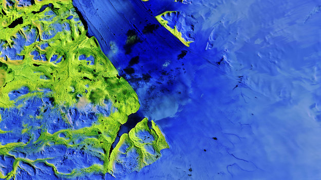
Earth observation image of the week: a Sentinel-2 image of one of Greenland’s largest glaciers, also featured on the Earth from Space video programme
POZVÁNKA - INTERGEO 2017
8.9.2017 9:0026.- 28.9.2017 / Berlín, Německo<br>
INTERGEO je předním světovým veletrhem pro geodézii, geoinformatiku a správu nemovitostí, který se může pochlubit návštěvností větší než 16.000 osob z 92 zemí světa. Přijeďte se také do Berlína podívat, jaké jsou na trhu novinky. Rádi Vás přivítáme na stánku TOPCON nebo SOKKIA.
20170908-VŘ Ředitel sekce centrální databáze katastru nemovitostí (2. kolo)
8.9.2017 8:47 ČÚZK - předpisy a opatření Český úřad zeměměřický a katastrální zveřejnil novou aktualitu: Oznámení o vyhlášení výběrového řízení na služební místo Ředitel sekce centrální databáze katastru nemovitostí (2. kolo).20170908-VŘ Ředitel sekce centrální databáze katastru nemovitostí (2. kolo)
8.9.2017 8:47 ČÚZK /Aktuality-resort/2017/20170908-VR-Reditel-sekce-centralni-databaze-katasVýzkum historických cest v interdisciplinárním kontextu (pozvánka)
8.9.2017 8:32 GISportal.cz Centrum dopravního výzkumu pořádá již třetí ročník konference Výzkum historických cest v interdisciplinárním kontextu, která je součástí projektu s Ministerstvem kultury. Akce se koná 2. a 3. listopadu v Brně a jejím cílem je prezentovat problematiku výzkumu ...systemizované místo rozhodování o povolení vkladu
8.9.2017 8:24 ČÚZK - předpisy a opatření Katastrální úřad pro Olomoucký kraj - Katastrální pracoviště Přerovvypisuje výběrové řízení na místo
systemizované místo rozhodování o povolení vkladu
systemizované místo rozhodování o povolení vkladu
8.9.2017 8:24 ČÚZK - volná místa Katastrální úřad pro Olomoucký kraj - Katastrální pracoviště Přerov vypisuje výběrové řízení na místo systemizované místo rozhodování o povolení vkladusystemizované místo rozhodování o povolení vkladu
8.9.2017 8:24 ČÚZK /Urady/Katastralni-urady/Katastralni-urady/Katastralni-urad-pro-Olomoucky-kraj/Volna-mista/systemizovane-misto-rozhodovani-o-povoleni-vkladuŘeditel sekce centrální databáze katastru nemovitostí (2.kolo)
8.9.2017 8:22 ČÚZK /Urady/Cesky-urad-zememericky-a-katastralni/Uredni-deska/Oznameni-a-jina-uredni-sdeleni/Volna-mista/reditel-sekce-centralni-databaze-katastru-nemo-(1)Ředitel sekce centrální databáze katastru nemovitostí (2.kolo)
8.9.2017 8:22 ČÚZK - volná místa Český úřad zeměměřický a katastrální vypisuje výběrové řízení na místo Ředitel sekce centrální databáze katastru nemovitostí (2.kolo)Ředitel sekce centrální databáze katastru nemovitostí (2.kolo)
8.9.2017 8:22 ČÚZK - předpisy a opatření Český úřad zeměměřický a katastrálnívypisuje výběrové řízení na místo
Ředitel sekce centrální databáze katastru nemovitostí (2.kolo)
CleveRA se rozšiřuje ze silnic i na letištní plochy
8.9.2017 2:00 VARS.czProjekt CleveRA se směle rozšiřuje ze silnic i na letištní ranveje, kde konkrétně v Ruzyni proběhlo měření a vyhodnocení nerovností a poruch.
Výzkum historických cest v interdisciplinárním kontextu III.
8.9.2017 0:00 Moravské křižovatky Odborná konference 2. až 3. listopadu 2017 v prostorách CDV v BrněExpedice Mars 2017 pokračuje
7.9.2017 17:28 Česká kosmická kancelář
Čtrnáctý ročník mezinárodní soutěže pro nadané studenty z České republiky a Slovenska zná deset finalistů, kteří ve dnech od 1. do 3. září zvítězili v semifinále. Nyní je čeká návštěva zajímavých kosmonautických míst doma i v zahraničí. Pětice finalistů ještě absolvuje více než stohodinový simulovaný let na Mars.
INSPIRE Hack 2017 úspěšný pro geomatiku!
7.9.2017 16:30 Blogující geomatici - FAV ZČU Tým vedený Karlem Jedličkou zvítězil v letošním ročníku INSPIRE Hackathonu s tématy "Open Data, Volunteered Geographic Information and Citizen Observatories", gratulujeme! Tým vytvořil dvě webové aplikace:- 3D OLU - perspektivní vizualizace Open Land Use pro Evropu nad digitálním modelem reliéfu (EU-DEM). Zajímavá je na této aplikaci možnost připojit do vizualizace libovolnou WMS službu (pokud je ve WGS-84).
- Farma Rostěnice - ukazuje data (sklon, orientace svahu, vegetační a topografický index), ze kterých je počítán výnosový potenciál polí pro farmu Rostěnice (jednoho z pilotních území projektu DataBio).
Zájemce o podrobnější zprávu z akce, konané letos již v rámci workshopů INSPIRE Conference, odkazujeme na informace přímo na stránkách pořadatele, asociace Plan4All (http://www.plan4all.eu/inspire-hack-2017/).
Agentura GSA slaví své páté výročí v Praze
7.9.2017 16:21 Český Kosmický PortálV září 2017 uplyne 5 let od otevření sídla Agentury pro evropský globální navigační družicový systém (GSA) v Praze - Holešovicích. V pražské centrále aktuálně pracuje na 120 odborníků na družicovou navigaci z celé Evropy, vč. 22 Čechů. Kromě vlastních zaměstnanců pracuje pro GSA v Praze také řada externích odborníků a dočasně přidělených národních expertů. Z Holešovic se tak na denní bázi řídí nejen evropský program družicoví navigace Galileo, který je obdobou amerického GPS, a EGNOS, poskytující zpřesňující informace ke Galileo i GPS, ale i síť center rozesetých po celé Evropě, které jsou pro Galileo i EGNOS nepostradatelné.
Vzniká Asociace podnikatelů v geomatice
7.9.2017 15:30 GeoBusinessPřetiskujeme výzvu předsedy České komory zeměměřičů ke vstupu nejen geodetů do nově vznikající oborové asociace. ASOCIACE PODNIKATELŮ V GEOMATICE (APG) Komora geodetů a kartografů, od 24. listopadu 2016 nesoucí název Česká…
The post Vzniká Asociace podnikatelů v geomatice appeared first on GeoBusiness.
Kdo vystoupí na konferenci firem Gepro a Atlas
7.9.2017 14:30 GeoBusinessSetkání uživatelů software Misys, Kokeš, Proland a Atlas se bude konat 24. a 25. října v Praze. První den konference je vyhrazen hlavním přednáškám, na druhý den jsou naplánovány pracovní…
The post Kdo vystoupí na konferenci firem Gepro a Atlas appeared first on GeoBusiness.
Senzory v aplikaci CleverFarm – informace hned při ruce
7.9.2017 14:15Zajímá vás, jaká je aktuální teplota a vlhkost na parcele v porostu či v půdě? Nebo zda se vám ve skladu/silu nespéká či neplesniví úroda? Všechny tyto informace můžete zjistit hned, z pohodlí vašeho domova či kanceláře, díky senzorům a aplikaci CleverFarm. Chytré řešení pro správu farmy nyní prochází dalšími testy a finálními úpravami.
Dosud byli farmáři odkázáni na klasické teploměry či senzory, které sice sbíraly informace o naměřené hodnotě, ale stáhnout se daly pouze přes flashdisk. Senzory pro aplikaci CleverFarm ale využívají ke komunikaci síť Sigfox, která umožňuje vzdálený přenos dat. Naměřené hodnoty jsou tedy v pravidelných intervalech posílány do aplikace a uživatel je informován bez nutnosti kamkoli jezdit. Četnost odezvy se dá nastavit od 10 minut po několik hodin a přizpůsobí se tak různým potřebám.
Mezi jednotlivé typy senzorů patří: senzor do porostu, půdy, meteostanice a senzor do skladu. Jednotlivé senzory nesou vždy informaci o teplotě a vlhkosti, senzory v půdě a skladu sledují informace v několika úrovních a meteostanice navíc sbírá množství srážek.

Na prvním obrázku je vidět seznam senzorů, aktivované senzory ukazují aktuální teplotu a vlhkost, neaktivní senzory zatím nebyly rozmístěny a čekají na spuštění uživatelem. Jednotlivé hodnoty se vždy ukládají do aplikace a uživatel může přehledně na grafu vidět, jak se vlhkost či teplota během dne měnily. V historických datech je pak možné zobrazit si i průměrnou vlhkost, teplotu a úhrn srážek v měsíci či v roce.

Zmíněné funkce aplikace CleverFarm v průběhu roku testujeme s farmáři a vylepšujeme dle potřeby. Hledáme, jaké informace jsou pro uživatele zajímavé, aby ze senzorů měl co největší přidanou hodnotu.
Dále plánujeme například možnost nastavení upozornění při překročení určené hranice. Uživatel by dostal upozornění, že teplota či vlhkost dosáhla kritické hranice a je nutné situaci řešit.
Modul i s jednotlivými senzory bude v prodeji od začátku roku 2018 a uživatelé aplikace CleverFarm se mají určitě na co těšit.
Senzory v aplikaci CleverFarm – informace hned při ruce
7.9.2017 14:15Zajímá vás, jaká je aktuální teplota a vlhkost na parcele v porostu či v půdě? Nebo zda ve skladu/silu se vám nespéká či neplesniví úroda? Všechny tyto informace můžete zjistit hned, z pohodlí vašeho domova či kanceláře, díky senzorům a aplikaci CleverFarm. Chytré řešení pro správu farmy nyní prochází dalšími testy a finálními úpravami.
Do dnešní doby, pokud chtěl farmář změřit např. teplotu, byl odkázán na klasické teploměry či senzory, které sice sbírali informace o naměřené hodnotě, ale stáhnout se daly pouze přes flashdisk. Senzory pro aplikaci CleverFarm, ale využívají ke komunikaci síť Sigfox, která umožňuje vzdálený přenos dat. Naměřené hodnoty jsou tedy v pravidelných intervalech posílány do aplikace a uživatel je informován bez nutnosti kamkoli jezdit. Četnost odezvy se dá nastavit od 10 minut po několik hodin a přizpůsobí se tak různým potřebám.
Mezi jednotlivé typy senzorů patří: senzor do porostu, půdy, meteostanice a senzor do skladu. Jednotlivé senzory nesou vždy informaci o teplotě a vlhkosti, senzory v půdě a skladu sledují informace v několika úrovních a meteostanice navíc sbírá množství srážek.
Na prvním obrázku je vidět seznam senzorů, aktivované senzory ukazují aktuální teplotu a vlhkost, neaktivní senzory, zatím nebyly rozmístěny a čekají na spuštění uživatelem. Jednotlivé hodnoty se vždy ukládají do aplikace a uživatel může pak přehledně na grafu vidět jak se vlhkost či teplota během dne měnily. V historických datech je pak možné zobrazit si i průměrnou vlhkost, teplotu a úhrn srážek v měsíci či v roce.
Zmíněné funkce aplikace CleverFarm v průběhu roku testujeme s farmáři a vylepšujeme dle potřeby. Hledáme, co vše má smysl uživateli zobrazovat, tak aby informace ze senzorů měly co nejvyšší přidanou hodnotu.
Dále plánujeme například možnost nastavení upozornění při překročení určené hranice. Uživatel by dostal upozornění, že teplota či vlhkost dosáhla kritické hranice a je nutné situaci řešit.
Modul i s jednotlivými senzory bude v prodeji od začátku roku 2018 a uživatelé aplikace CleverFarm se mají určitě na co těšit.
Earth from Space
7.9.2017 14:04 ESA Observing the Earth
Join us Friday, 8 September, at 10:00 CEST for the ‘Earth from Space’ video programme
Earth from Space
7.9.2017 14:04 ESA Observing the EarthJoin us Friday, 8 September, at 10:00 CEST for the ‘Earth from Space’ video programme
Komentovali jsme pro E15 záměr využití dronů k vysazování lesů v zahraničí
7.9.2017 13:53 UpVision Drony mají v zemědělství a ochraně přírody velký potenciál. Komentovali jsme pro E15 záměr využití dronů k vysazování lesů v zahraničí.Více zde:
http://zpravy.e15.cz/byznys/zemedelstvi/do-boje-s-ubytkem-lesu-vstupuji-drony-mohly-by-vysazet-miliony-stromu-technologie-meni-i-zemedelstvi-1336912
3D, chytré appky, inženýrské sítě: To budou workshopy na konferenci Hexagonu
7.9.2017 12:42 GeoBusinessLetošní konference Hexagonu se blíží, bude se konat 18. a 19. září ve Valči. Konference má být zaměřena na tzv. chytré aplikace. Organizátoři konference HxGN LOCAL GeoForum cs 2017 oznámili…
The post 3D, chytré appky, inženýrské sítě: To budou workshopy na konferenci Hexagonu appeared first on GeoBusiness.
V mapové aplikaci Investiční a
7.9.2017 12:00 Jihočeský kraj V mapové aplikaci Investiční akce 2017 (https://gisportal.kraj-jihocesky.gov.cz/arcgis/apps/webappviewer/index.html?id=466a55ed842b4e438b4c6c09a96c4ea1) byly doplněny informace k uzavírkám mostu 1359-2 v obci Ústrašice, silnice III/00349 v Sezimově Ústí, silnice III/00430 Hajská - Přední Ptákovice, silnice III/1709 Kraselov - Němčice a silnice II/170 Němětice - Nihošovice.V Geoportálu ÚAP Ústeckého kra
7.9.2017 12:00 Ústecký kraj V Geoportálu ÚAP Ústeckého kraje byla provedena aktualizace údajů pro poskytovatele ČEPS, a.s. – jev 72, 73V mapové aplikaci Investiční a
7.9.2017 12:00 Jihočeský kraj V mapové aplikaci Investiční akce 2017 byly doplněny informace k uzavírkám mostu 1359-2 v obci Ústrašice, silnice III/00349 v Sezimově Ústí, silnice III/00430 Hajská - Přední Ptákovice, silnice III/1709 Kraselov - Němčice a silnice II/170 Němětice - Nihošovice.odborný referent - poskytování informací KN, poskytování podkladů, nahlížení do KN, poskytování info
7.9.2017 10:57 ČÚZK - volná místa Katastrální úřad pro Zlínský kraj - Katastrální pracoviště Valašské Klobouky vypisuje výběrové řízení na místo odborný referent - poskytování informací KN, poskytování podkladů, nahlížení do KN, poskytování infoodborný referent - poskytování informací KN, poskytování podkladů, nahlížení do KN, poskytování info
7.9.2017 10:57 ČÚZK - předpisy a opatření Katastrální úřad pro Zlínský kraj - Katastrální pracoviště Valašské Kloboukyvypisuje výběrové řízení na místo odborný referent - poskytování informací KN, poskytování podkladů, nahlížení do KN, poskytování informací PK v oddělení aktualizace a dokumentace KN
odborný referent - poskytování informací KN, poskytování podkladů, nahlížení do KN, poskytování informací PK v oddělení aktualizace a dokumentace KN
odborný referent - poskytování informací KN, poskytování podkladů, nahlížení do KN, poskytování info
7.9.2017 10:57 ČÚZK /Urady/Katastralni-urady/Katastralni-urady/Katastralni-urad-pro-Zlinsky-kraj/Uredni-deska/Oznameni-a-jina-uredni-sdeleni/Volna-mista/odborny-referent-poskytovani-informaci-KN,-poskyodborný referent / vrchní referent - operátor informačních a komunikačních technologií (analytik inf
7.9.2017 10:54 ČÚZK - předpisy a opatření Katastrální úřad pro Zlínský krajvypisuje výběrové řízení na místo odborný referent / vrchní referent - operátor informačních a komunikačních technologií (analytik informačních systémů) v oddělení podpory informačních a komunikačních
odborný referent / vrchní referent - operátor informačních a komunikačních technologií (analytik informačních systémů) v oddělení podpory informačních a komunikačních technologií
odborný referent / vrchní referent - operátor informačních a komunikačních technologií (analytik inf
7.9.2017 10:54 ČÚZK - volná místa Katastrální úřad pro Zlínský kraj vypisuje výběrové řízení na místo odborný referent / vrchní referent - operátor informačních a komunikačních technologií (analytik infodborný referent / vrchní referent - operátor informačních a komunikačních technologií (analytik inf
7.9.2017 10:54 ČÚZK /Urady/Katastralni-urady/Katastralni-urady/Katastralni-urad-pro-Zlinsky-kraj/Uredni-deska/Oznameni-a-jina-uredni-sdeleni/Volna-mista/odborny-referent-vrchni-referent-operator-info20170907-Zkoušky ÚOZI
7.9.2017 10:31 ČÚZK - předpisy a opatření Český úřad zeměměřický a katastrální zveřejnil novou aktualitu: Zkoušky ÚOZI proběhnou 27. září 2017.Nabídka GIS brigády
7.9.2017 8:36 GISportal.cz Máte zájem o brigádu v oboru? Zkuste nabídku IterSoftu.Odborný referent - obnova katastrálního operátu
7.9.2017 8:10 ČÚZK - předpisy a opatření Katastrální úřad pro Plzeňský krajvypisuje výběrové řízení na místo
Odborný referent - obnova katastrálního operátu
Odborný referent - obnova katastrálního operátu
7.9.2017 8:10 ČÚZK - volná místa Katastrální úřad pro Plzeňský kraj vypisuje výběrové řízení na místo Odborný referent - obnova katastrálního operátuOdborný referent - obnova katastrálního operátu
7.9.2017 8:10 ČÚZK /Urady/Katastralni-urady/Katastralni-urady/Katastralni-urad-pro-Plzensky-kraj/Uredni-deska/Oznameni-a-jina-uredni-sdeleni/Volna-mista/Odborny-referent-obnova-katastralniho-operatu-(1)Nová služební místa
7.9.2017 8:05 ČÚZK - předpisy a opatření Katastrální úřad pro hlavní město Prahu - Katastrální pracoviště Praha zveřejnil novou aktualitu: Nově vyhlášené výběrové řízení na služební pozici:* Referent KN – právník
* Referent KN – návrh zápisu, kontrola a zplatnění
Nová služební místa
7.9.2017 8:05 ČÚZK /Urady/Katastralni-urady/Katastralni-urady/Katastralni-urad-pro-hlavni-mesto-Prahu/O-uradu/Aktuality/Nova-sluzebni-mistaReferent KN – návrh zápisu, kontrola a zplatnění
7.9.2017 8:00 ČÚZK - předpisy a opatření Katastrální úřad pro hlavní město Prahu - Katastrální pracoviště Prahavypisuje výběrové řízení na místo
Referent KN – návrh zápisu, kontrola a zplatnění
Referent KN – návrh zápisu, kontrola a zplatnění
7.9.2017 8:00 ČÚZK - volná místa Katastrální úřad pro hlavní město Prahu - Katastrální pracoviště Praha vypisuje výběrové řízení na místo Referent KN – návrh zápisu, kontrola a zplatněníReferent KN – právník
7.9.2017 7:54 ČÚZK /Urady/Katastralni-urady/Katastralni-urady/Katastralni-urad-pro-hlavni-mesto-Prahu/Uredni-deska/Oznameni-a-jina-uredni-sdeleni/Volna-mista/Referent-KN-–-pravnik-(2)Referent KN – právník
7.9.2017 7:54 ČÚZK - předpisy a opatření Katastrální úřad pro hlavní město Prahu - Katastrální pracoviště Prahavypisuje výběrové řízení na místo
Referent KN – právník
Referent KN – právník
7.9.2017 7:54 ČÚZK - volná místa Katastrální úřad pro hlavní město Prahu - Katastrální pracoviště Praha vypisuje výběrové řízení na místo Referent KN – právníkVeľký úspech mladých slovenských geografov na IGEO 2017 v Srbsku
7.9.2017 7:21 Geocommunity.skV srbskom Belehrade sa pred mesiacom uskutočnila v poradí už štrnásta Medzinárodná geografická olympiáda (International Geography Olympiad – IGEO). Je to súťaž mladých geografov a geografiek vo veku od 16 do 19 rokov. Naši reprezentanti získali zlato a bronz. International Geography Olympiad IGEO sa pravidelne zúčastňuje viac ako 40 krajín a počet súťažiacich býva okolo … … Čítať ďalej
Príspevok Veľký úspech mladých slovenských geografov na IGEO 2017 v Srbsku zobrazený najskôr GeoCommunity.sk.