


![]()

zprávy
zdroje zpráv:vyhlášená výběrová řízení (1)
1.2.2017 11:12 ČÚZK /Urady/Katastralni-urady/Katastralni-urady/Katastralni-urad-pro-hlavni-mesto-Prahu/O-uradu/Aktuality/vyhlasena-vyberova-rizeni-(1)vyhlášená výběrová řízení (1)
1.2.2017 11:12 ČÚZK - předpisy a opatření Nově vyhlášená výběrová řízení na služební místa:Refener KN - posk. informací KN8
Refener KN - pracovník výpravny
Refener KN - právník
Refener KN - posk. informací KN9
vyhlášená výběrová řízení (1)
1.2.2017 11:12 ČÚZK - předpisy a opatření Nově vyhlášená výběrová řízení na služební místa:Referent KN - posk. informací KN8
Referent KN - pracovník výpravny
Referent KN - právník
Referent KN - posk. informací KN9
Jakub je spoluautorem knihy Metodika identifikace drenážních systémů která vychází u VÚMOPu
1.2.2017 11:09 UpVision Minulý týden šla do tisku kniha Metodika identifikace drenážních systémů a stanovení jejich funkčnosti, na které jsme spolupracovali a která je výsledkem naší několikaleté spolupráce s Výzkumným ústavem meliorací a ochrany půdy.Náhled knihy zde:
https://plus.google.com/+UpvisionCz1/posts/Wgjq1Bofo25
vyhlášená výběrová řízení
1.2.2017 11:09 ČÚZK - předpisy a opatření Nově vyhlášená výběrová řízení na služební místa:Právník katastru nemovitostí
Technik v zeměměřictví a katastru
vyhlášená výběrová řízení
1.2.2017 11:09 ČÚZK /Urady/Katastralni-urady/Katastralni-urady/Katastralni-urad-pro-hlavni-mesto-Prahu/O-uradu/Aktuality/vyhlasena-vyberova-rizeniDružice pro studium větru se těší na závěrečné testy
1.2.2017 10:57 Český Kosmický PortálCesta k realizaci mise ESA Aeolus je dlouhá a trnitá, jenže vývoj nových kosmických technologií s sebou zkrátka výzvy přináší. Poté, co nyní byla družice vybavena svým revolučním přístrojem, měla by před ní být už jen cesta do vesmíru. Na ní se ovšem ještě zastaví ve Francii, kde na ni čeká závěrečné kolo zkoušek. A pak před koncem roku odeslání na kosmodrom.
Reportáž z workshopu „Otevřená data a otevřený software nejen pro komerční sektor“ na Novotného lávce v Praze
1.2.2017 8:46 GISportal.cz Dne 23. ledna 2017 se uskutečnilo již podruhé „tradiční“ setkání příznivců rozumného otevírání (geo)dat. A když už hovoříme o tradicích, i tentokrát bylo přítomné mrazivé počasí, které kontrastovalo s příjemnou atmosférou v sále. Na úvod byly krátce představeny ...Konference Inspirujme se... 2018 - první informace
1.2.2017 7:00 Česká asociace pro geoinformace Další (již desátý) ročník konference Inspirujme se.. proběhne ve dnech 27. a 28. února 2018 ve Vzdělávacím a informačním centru Fleret v Průhonicích. O bližších podrobnostech vás budeme v průběhu zimyNávrh Metropolitního plánu Prahy zveřejněn
1.2.2017 7:00 Česká asociace pro geoinformace Veřejnost se může od konce listopadu seznámit s návrhem Metropolitního plánu, územního plánu Prahy, jenž nyní prochází vyhodnocením vlivu na udržitelný rozvoj. Projednávání plánu s jednotlivými městskými částmi, dotčenými orgány a veřejností pak začne příští rok na jaře.Kompletní návrh plánu je zveřejněn na webu Institutu pro plánování a rozvoj.
22. kartografická konference Liberec
1.2.2017 7:00 Česká asociace pro geoinformace Česká kartografická společnost a Technická univerzita v Liberci pořádají od 6. do 8. září 2017 22. kartografickou konferenci, tradiční setkání českých a slovenských kartografů, letos s podtitulem Kartografie bez hranic.Organizátoři již spustili webovou registraci, zveřejnili hrubý program a vypsali konferenční granty.
Navštivte konferenční web a dozvíte se vše
Oznámení o vložení nové nabídky do Nabídky pronájmu nebytových prostor
1.2.2017 0:00 Státní pozemkový úřad Na webových stránkách byla vložena nová nabídka typu Nabídky pronájmu nebytových prostor, která je dostupná od 01.02.2017Bentley to put AEC Models on the Map
31.1.2017 16:59 Bentley SystemsPress Coverage
ARC Advisory Group
Read the articleSiemens, Bentley Systems to co-develop new utility planning and design software
31.1.2017 16:56 Bentley SystemsPress Coverage
Read the Article
Read the articleSiemens and Bentley Systems Agree to Jointly Offer Planning and Design Solutions for Utilities
31.1.2017 15:34 Bentley SystemsSan Diego, U.S.A. – DistribuTECH 2017 – Building on the strategic alliance between Siemens and Bentley Systems that was made public in November 2016, Siemens’ Energy Management Division and Bentley Systems have announced an agreement to jointly develop solutions to accelerate digitalization of planning, design, and operations for power utilities and industrial power customers. Bentley Systems is a global leader in software solutions for advancing the design, construction, and operations of infrastructure. The first of the new offerings will integrate Bentley Systems’ utility design and geographic information systems (GIS) capabilities with Siemens’ Power System Simulation (PSS) Suite, with specific solutions for power transmission, power distribution, and industrial facilities. Combining these two platforms provides customers with Bentley’s expertise in 3D infrastructure asset modeling and GIS with Siemens’ knowledge and renowned experience in energy system planning and simulation.
“The energy industry trend toward decentralization represents a significant challenge as well as a great opportunity for power producers and consumers alike, and our strategic alliance with Bentley Systems will help our customers better leverage this changing landscape through the combination of our powerful solutions,” said Ralf Christian, CEO of the Siemens Energy Management Division. “Siemens and Bentley share a commitment to openness, interoperability, and the common goal of helping our customers drive the digital enterprise across their supply chains.”
Bentley Systems Chief Product Officer Bhupinder Singh said, “We are excited to collaborate with Siemens to help our power utilities users advance in ‘going digital.’ Siemens’ expertise in electrical power systems planning and simulation are the perfect complement to our GIS and infrastructure engineering solutions, and we will work together to bring new innovations and tangible business benefits to our users around the world.”
Distributed energy resources (DER), like microgrids and their off-grid on-grid mode, require more advanced planning approaches to ensure system reliability and stability. Bentley’s OpenUtilities solution for utility power grid design and GIS will be integrated with Siemens’ PSS Suite for power system planning to provide seamless workflows and data integration, while supporting optimal network design for both operational and economic performance. Through a connected data environment, utility engineers will now have the added benefit of sharing critical design information to reduce design time and construction costs to deliver optimal and comprehensive utility network updates.
In addition, the Siemens Bentley initiative will provide intelligent Siemens components for easy placement into Bentley’s Substation application for 3D modeling, while intelligent electrical symbols will provide necessary details for comprehensive reports in a substation’s 2D schematic layout capabilities. Bentley users will have access to a comprehensive Siemens’ components catalog through Bentley’s cloud services.
This press release is available at www.siemens.com/press/PR2017010xxxEMEN.
Attendees of the DistribuTECH 2017 Conference are invited to visit Siemens in booth 3113 and Bentley Systems in booth 1431.
Siemens AG (Berlin and Munich) is a global technology powerhouse that has stood for engineering excellence, innovation, quality, reliability and internationality for more than 165 years. The company is active in more than 200 countries, focusing on the areas of electrification, automation and digitalization. One of the world’s largest producers of energy-efficient, resource-saving technologies, Siemens is a leading supplier of efficient power generation and power transmission solutions and a pioneer in infrastructure solutions as well as automation, drive and software solutions for industry. The company is also a leading provider of medical imaging equipment – such as computed tomography and magnetic resonance imaging systems – and a leader in laboratory diagnostics as well as clinical IT. In fiscal 2016, which ended on September 30, 2016, Siemens generated revenue of €79.6 billion and net income of €5.6 billion. At the end of September 2016, the company had around 351,000 employees worldwide. Further information is available on the Internet at www.siemens.com.
Bentley Systems is a global leader in providing architects, engineers, geospatial professionals, constructors, and owner-operators with comprehensive software solutions for advancing the design, construction, and operations of infrastructure. Bentley users leverage information mobility across disciplines and throughout the infrastructure lifecycle to deliver better-performing projects and assets. Bentley solutions encompass MicroStation applications for information modeling, ProjectWise collaboration services to deliver integrated projects, and AssetWise operations services to achieve intelligent infrastructure – complemented by worldwide professional services and comprehensive managed services. Founded in 1984, Bentley has more than 3,000 colleagues in over 50 countries, more than $600 million in annual revenues, and since 2009 has invested more than $1 billion in research, development, and acquisitions. Additional information is available at www.bentley.com.
# # #
Bentley, the “B” Bentley logo, Be, MicroStation, ProjectWise, and Bentley Substation are either registered or unregistered trademarks or service marks of Bentley Systems, Incorporated or one of its direct or indirect wholly owned subsidiaries. All other brands and product names are trademarks of their respective owners.
Chcete být geodetem ve Skandinávii?
31.1.2017 15:34 Blogující geomatici - FAV ZČU Firma Exact Control System a.s. nabízí lukrativní pozici geodeta pro krátkodobé i dlouhodobé projekty ve Skandinávii. Více informací viz přiložený obrázek.
2016
31.1.2017 14:12 ČÚZK /Urady/Zememericke-a-katastralni-inspektoraty/Zememericke-a-katastralni-inspektoraty/Zememericky-a-katastralni-inspektorat-v-Liberci/Casto-hledane-informace/Informace-o-vysledcich-kontrol-dle-§-26-zakona-c-2/20162016
31.1.2017 14:12 ČÚZK - předpisy a opatření Zeměměřický a katastrální inspektorát v Libercivydává výroční zprávu úřadu za rok
2016
Nabídka práce v Olomouci/Brně
31.1.2017 13:58 GISportal.cz Správa železniční dopravní cesty hledá (GIS) vývojáře/ku.20170131 - Pracovní seminář "Webové služby ISÚI/RÚIAN"
31.1.2017 13:24 ČÚZK - předpisy a opatření
Dne 2. 3. 2017 se v budově ČÚZK v Praze uskuteční pracovní seminář k problematice "Webové služby ISÚI/RÚIAN".
Více informací v pozvánce.
20170131 - Pracovní seminář "Webové služby ISÚI/RÚIAN"
31.1.2017 13:24 ČÚZK - předpisy a opatřeníDne 2. 3. 2017 se v budově ČÚZK v Praze uskuteční pracovní seminář k problematice "Webové služby ISÚI/RÚIAN". Více informací v pozvánce.
Zveřejněno 31. 1. 201720170131 - Pracovní seminář "Webové služby ISÚI/RÚIAN"
31.1.2017 13:24 ČÚZK /Uvod/Produkty-a-sluzby/RUIAN/1-Editacni-agendovy-system-ISUI/Editacni-webove-sluzby-ISUI/Archiv-novinky/20170131-Pracovni-seminar-Webove-sluzby-ISUI-RUIAN20170131 - Pracovní seminář "Webové služby ISÚI/RÚIAN"
31.1.2017 13:24 ČÚZK - předpisy a opatření Dne 2. 3. 2017 se v budově ČÚZK v Praze uskuteční pracovní seminář k problematice "Webové služby ISÚI/RÚIAN".Více informací v pozvánce.
20170131 - Pracovní seminář "Webové služby ISÚI/RÚIAN"
31.1.2017 13:24 ČÚZK /Uvod/Produkty-a-sluzby/RUIAN/1-Editacni-agendovy-system-ISUI/Editacni-webove-sluzby-ISUI/Archiv-novinky/20170131-Pracovni-seminar-Webove-sluzby-ISUI-RUIAN20170131 - Pracovní seminář "Webové služby ISÚI/RÚIAN"
31.1.2017 13:16 ČÚZK - předpisy a opatřeníDne 2. 3. 2017 se v budově ČÚZK v Praze uskuteční pracovní seminář k problematice "Webové služby ISÚI/RÚIAN". Více informací v pozvánce.
Zveřejněno 31. 1. 201720170131 - Pracovní seminář "Webové služby ISÚI/RÚIAN"
31.1.2017 13:16 ČÚZK - předpisy a opatřeníDne 2. 3. 2017 se v budově ČÚZK v Praze uskuteční pracovní seminář k problematice "Webové služby ISÚI/RÚIAN". Více informací v pozvánce.
Zveřejněno 31. 1. 201720170131 - Pracovní seminář "Webové služby ISÚI/RÚIAN"
31.1.2017 13:16 ČÚZK - předpisy a opatřeníDne 2. 3. 2017 se v budově ČÚZK v Praze uskuteční pracovní seminář k problematice "Webové služby ISÚI/RÚIAN". Více informací v pozvánce.
Zveřejněno 31. 1. 201720170131 - Pracovní seminář "Webové služby ISÚI/RÚIAN"
31.1.2017 13:16 ČÚZK /Uvod/Produkty-a-sluzby/RUIAN/RUIAN-novinky/2016/20170131-Pracovni-seminar-Webove-sluzby-ISUI-RUIAN20170131 - Pracovní seminář "Webové služby ISÚI/RÚIAN"
31.1.2017 13:16 ČÚZK /Uvod/Produkty-a-sluzby/RUIAN/RUIAN-novinky/20170131-Pracovni-seminar-Webove-sluzby-ISUI-RUIANV seznamu mapových služeb obla
31.1.2017 12:00 Plzeňský kraj V seznamu mapových služeb oblasti Doprava a silniční hospodářství (http://geoportal.plzensky-kraj.cz/gs/doprava-a-silnicni-hospodastvi) byla rozšířena mapová služba Dopravní nehodovost na silnicích v Plzeňském kraji (http://mapy.kr-plzensky.cz/gis/dopravni_nehody) o údaje za rok 2016. Po kliknutí na patřičný silniční úsek se vypíší podrobné údaje o nehodovosti. Mapa byla vytvořena ve spolupráci s Policií ČR.V seznamu mapových služeb obla
31.1.2017 12:00 Plzeňský kraj V seznamu mapových služeb oblasti Doprava a silniční hospodářství (http://geoportal.plzensky-kraj.cz/gs/doprava-a-silnicni-hospodastvi) byla aktualizována mapa zobrazující plánované investice do silnic II. a III. třídy (tzv. Modrá kniha investičních záměrů) (http://mapy.kr-plzensky.cz/gis/suspk_projekty) dle podkladů Správy a údržby silnic Plzeňského kraje.V seznamu mapových služeb obla
31.1.2017 12:00 Plzeňský kraj V seznamu mapových služeb oblasti Doprava a silniční hospodářství byla rozšířena mapová služba Dopravní nehodovost na silnicích v Plzeňském kraji o údaje za rok 2016. Po kliknutí na patřičný silniční úsek se vypíší podrobné údaje o nehodovosti. Mapa byla vytvořena ve spolupráci s Policií ČR.V seznamu mapových služeb obla
31.1.2017 12:00 Plzeňský kraj V seznamu mapových služeb oblasti Doprava a silniční hospodářství byla aktualizována mapa zobrazující plánované investice do silnic II. a III. třídy (tzv. Modrá kniha investičních záměrů) dle podkladů Správy a údržby silnic Plzeňského kraje.CEDA opět aktivně působí v SDT
31.1.2017 11:00 CEDA Maps a.s. Praha, 31. 1. 2017 - S potěšením bychom vás chtěli informovat, že od 1. 2. 2017 jsme opět řádným členem Sdružení pro dopravní telematiku, z.s. (SDT) s aktivním působením především v pracovní skupině pro Digitální mapy a dopravní informace.Sledování sondy Cassini
31.1.2017 10:55 Český Kosmický PortálV polovině ledna paraboly ESA pro zachytávání signálu z hlubokého vesmíru zaměřily na dvou kontinentech svoji pozornost na signály přicházející ze sondy Cassini, jejíž mise u planety Saturn se blíží do finále.
ArcRevue 4/2016
31.1.2017 10:44 ARCDATAArcRevue 4/2016 vám přináší články o Metropolitním plánu Prahy, analýzách výškopisu, GIS v archeologii, Survey 123 for ArcGIS a o vektorových dlaždicích. Stáhnout si ho můžete na stránkách časopisu.

PRÁVNÍK - REFERENT ODDĚLENÍ PRÁVNÍCH VZTAHŮ zástup na dobu určitou za mateřskou/rodičovskou dovoleno
31.1.2017 10:19 ČÚZK - volná místa Katastrální úřad pro Plzeňský kraj, Katastrální pracoviště Rokycany vypisuje výběrové řízení na místo PRÁVNÍK - REFERENT ODDĚLENÍ PRÁVNÍCH VZTAHŮ zástup na dobu určitou za mateřskou/rodičovskou dovolenoPRÁVNÍK - REFERENT ODDĚLENÍ PRÁVNÍCH VZTAHŮ zástup na dobu určitou za mateřskou/rodičovskou dovoleno
31.1.2017 10:19 ČÚZK - předpisy a opatření Katastrální úřad pro Plzeňský kraj Katastrální pracoviště Rokycanyvypisuje výběrové řízení na místo
PRÁVNÍK - REFERENT ODDĚLENÍ PRÁVNÍCH VZTAHŮ zástup na dobu určitou za mateřskou/rodičovskou dovolenou
PRÁVNÍK - REFERENT ODDĚLENÍ PRÁVNÍCH VZTAHŮ zástup na dobu určitou za mateřskou/rodičovskou dovoleno
31.1.2017 10:19 ČÚZK /Urady/Katastralni-urady/Katastralni-urady/Katastralni-urad-pro-Plzensky-kraj/Volna-mista/PRAVNIKA-REFERENTA-ODDELENI-PRAVNICH-VZTAHU-zastupReferent KN – poskytování informací KN 9. PT
31.1.2017 9:34 ČÚZK /Urady/Katastralni-urady/Katastralni-urady/Katastralni-urad-pro-hlavni-mesto-Prahu/Uredni-deska/Oznameni-a-jina-uredni-sdeleni/Volna-mista/Referent-KN-–-poskytovani-informaci-KN-9-PTReferent KN – poskytování informací KN 9. PT
31.1.2017 9:34 ČÚZK - volná místa Katastrální úřad pro hlavní město Prahu, Katastrální pracoviště Praha vypisuje výběrové řízení na místo Referent KN – poskytování informací KN 9. PTReferent KN – poskytování informací KN 9. PT
31.1.2017 9:34 ČÚZK - předpisy a opatření Katastrální úřad pro hlavní město Prahu Katastrální pracoviště Prahavypisuje výběrové řízení na místo
Referent KN – poskytování informací KN 9. PT
2016
31.1.2017 7:58 ČÚZK - předpisy a opatření Zeměměřický a katastrální inspektorát v Opavěvydává výroční zprávu úřadu za rok 2016
2016
Informace o výsledcích kontrol dle § 26 zákona č. 255/2012 Sb. za rok 2016
31.1.2017 7:58 ČÚZK /Urady/Zememericke-a-katastralni-inspektoraty/Zememericke-a-katastralni-inspektoraty/Zememericky-a-katastralni-inspektorat-v-Opave/Casto-hledane-informace/Informace-o-vysledcich-kontrol-dle-§-26-zakona-c-2/20162016
31.1.2017 7:58 ČÚZK /Urady/Zememericke-a-katastralni-inspektoraty/Zememericke-a-katastralni-inspektoraty/Zememericky-a-katastralni-inspektorat-v-Opave/Casto-hledane-informace/Informace-o-vysledcich-kontrol-dle-§-26-zakona-c-2/2016Informace o výsledcích kontrol dle § 26 zákona č. 255/2012 Sb. za rok 2016
31.1.2017 7:58 ČÚZK - předpisy a opatření Zeměměřický a katastrální inspektorát v Opavěvydává informace o výsledcích kontrol dle § 26 zákona č. 255/2012 Sb. za rok 2016
2016
Technik v zeměměřictví a katastru
30.1.2017 15:08 ČÚZK - předpisy a opatření Katastrální úřad pro hlavní město Prahu Katastrální pracoviště Prahavypisuje výběrové řízení na místo
Technik v zeměměřictví a katastru
Technik v zeměměřictví a katastru
30.1.2017 15:08 ČÚZK - volná místa Katastrální úřad pro hlavní město Prahu, Katastrální pracoviště Praha vypisuje výběrové řízení na místo Technik v zeměměřictví a katastru2016
30.1.2017 15:07 ČÚZK /Urady/Zememericke-a-katastralni-inspektoraty/Zememericke-a-katastralni-inspektoraty/Zememericky-a-katastralni-inspektorat-v-CB/Casto-hledane-informace/Informace-o-vysledcich-kontrol-dle-§-26-zakona-c-2/20162016
30.1.2017 15:07 ČÚZK - předpisy a opatření Zeměměřický a katastrální inspektorát v Českých Budějovicíchvydává výroční zprávu úřadu za rok
2016
Referent KN – poskytování informací KN 8. PT
30.1.2017 15:03 ČÚZK - volná místa Katastrální úřad pro hlavní město Prahu, Katastrální pracoviště Praha vypisuje výběrové řízení na místo Referent KN – poskytování informací KN 8. PTReferent KN – poskytování informací KN 8. PT
30.1.2017 15:03 ČÚZK - předpisy a opatření Katastrální úřad pro hlavní město Prahu Katastrální pracoviště Prahavypisuje výběrové řízení na místo
Referent KN – poskytování informací KN 8. PT
Referent KN – poskytování informací KN 8. PT
30.1.2017 15:03 ČÚZK /Urady/Katastralni-urady/Katastralni-urady/Katastralni-urad-pro-hlavni-mesto-Prahu/Uredni-deska/Oznameni-a-jina-uredni-sdeleni/Volna-mista/Referent-KN-–-poskytovani-informaci-KNReferent KN – pracovník výpravny
30.1.2017 15:01 ČÚZK - volná místa Katastrální úřad pro hlavní město Prahu, Katastrální pracoviště Praha vypisuje výběrové řízení na místo Referent KN – pracovník výpravnyReferent KN – pracovník výpravny
30.1.2017 15:01 ČÚZK - předpisy a opatření Katastrální úřad pro hlavní město Prahu Katastrální pracoviště Prahavypisuje výběrové řízení na místo
Referent KN – pracovník výpravny
Wind satellite heads for final testing
30.1.2017 13:15 ESA Observing the Earth
The road to realising ESA’s Aeolus mission may have been long and bumpy, but developing novel space technology is, by its very nature, challenging. With the satellite now equipped with its revolutionary instrument, the path ahead is much smoother as it heads to France to begin the last round of tests before being shipped to the launch site at the end of the year.
Nově bylo uveřejněno 7 dalších
30.1.2017 12:00 Plzeňský kraj Nově bylo uveřejněno 7 dalších územně plánovacích dokumentací. Vyhledat příslušnou územně plánovací dokumentaci můžete v sekci Územní plánování » Obce v kraji » Územní plány a další nástroje územního plánování (http://geoportal.plzensky-kraj.cz/gs/uzemni-plany-a-dalsi-nastroje-uzemniho-planovani/). Nově jsou k dispozici následující dokumentace: Územní plán Vranov, Změna č. 2 ÚPO Bezdružice, ÚP Dlažov změna č.1, Změna č.1 ÚP Horní Kozolupy, Územní plán Horní Kozolupy, Územní plán Cheznovice, Změna č. 1 Územního plánu obce Záchlumí.Mapová aplikace byla aktualiz
30.1.2017 12:00 Jihočeský kraj Mapová aplikace byla aktualizována k 27. 1. 2017.Nově bylo uveřejněno 7 dalších
30.1.2017 12:00 Plzeňský kraj Nově bylo uveřejněno 7 dalších územně plánovacích dokumentací. Vyhledat příslušnou územně plánovací dokumentaci můžete v sekci Územní plánování » Obce v kraji » Územní plány a další nástroje územního plánování. Nově jsou k dispozici následující dokumentace: Územní plán Vranov, Změna č. 2 ÚPO Bezdružice, ÚP Dlažov změna č.1, Změna č.1 ÚP Horní Kozolupy, Územní plán Horní Kozolupy, Územní plán Cheznovice, Změna č. 1 Územního plánu obce Záchlumí.Mapová aplikace Územně analyti
30.1.2017 12:00 Jihočeský kraj Mapová aplikace Územně analytické podklady byla aktualizována k 27. 1. 2017.2016
30.1.2017 11:38 ČÚZK /Urady/Katastralni-urady/Katastralni-urady/Katastralni-urad-pro-Liberecky-kraj/Vyrocni-zpravy/20162016
30.1.2017 11:38 ČÚZK - předpisy a opatření Katastrální úřad pro Liberecký krajvydává výroční zprávu úřadu za rok 2016
2016
První družice SmallGEOs dosáhla oběžné dráhy
30.1.2017 10:38 Český Kosmický PortálNová malá telekomunikační platforma ESA se vydala na svoji první kosmickou misi.
První družice SmallGEOs dosáhla oběžné dráhy
30.1.2017 10:38 Český Kosmický PortálNová malá telekomunikační platforma ESA se vydala na svoji první kosmickou misi.
Larsen crack
30.1.2017 9:30 ESA Observing the Earth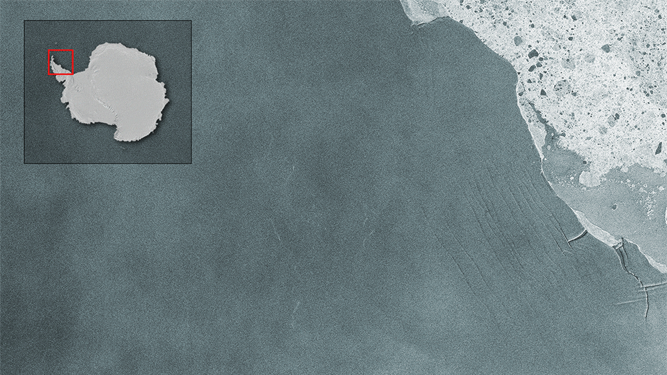
With its radar vision, Sentinel-1 is monitoring a rift in the Larsen-C ice shelf that will eventually calve one of the biggest icebergs ever recorded
On-line kurz na tvorbu aplikací: Do-It-Yourself Geo Apps
30.1.2017 9:21 ARCDATAJiž tuto středu 1. února začíná on-line vzdělávací kurz Do-It-Yourself Geo Apps, který je zaměřený na tvorbu aplikací i bez znalosti programování. Naučíte se vytvářet webové i mobilní aplikace, které můžete využít při své práci nebo pro publikaci dat veřejnosti. Kurz vás také naučí, jak je možné základní aplikace upravovat a doplňovat vlastním kódem.
Těšit se můžete na:
- 7 lekcí ve 4 týdnech výuky,
- video přednášky, kvízy a diskuze,
- Web AppBuilder a AppStudio for ArcGIS,
- certifikát po dokončení kurzu.
Přihlaste se ještě dnes, výuka začíná ve středu 1. února.

Don’t get left out in the cold!
30.1.2017 9:08 European GNSS Agency
Do winter weather conditions have an effect on the accuracy and use of mass-market GNSS devices? To find out, the European GNSS Agency (GSA) asked the experts working in Antarctica.
The holidays are over and all we are left with is another couple of months of cold, wet and foggy winter weather. And there’s nothing worse than having to travel in winter weather conditions. Whether it’s walking to a meeting or driving across town, at least you can depend on global navigation satellite systems (GNSS), including Galileo, to help guide you to your destination along the most efficient route possible. All you have to do is plug the coordinates into your smartphone or in-vehicle navigation device, bundle up and head out – letting GNSS take care of the rest.
This is of course assuming that GNSS isn’t affected by the rain, snow, fog and dense clouds that define winter in much of Europe. After all, if the satellite signals are delayed or unable to reach the receiver in your device, you might just find yourself left out in the cold!
To get to the bottom of this, we asked some experts about the effect, if any, that the winter weather has on your use of GNSS devices.
Navigate like a penguin
If you really want to see how winter weather impacts the use of GNSS, there’s really no better place to conduct your research than Antarctica. Nicola Umberto, a researcher at Politecnico di Torino, recently travelled there to install a GNSS monitoring station – one of the first researchers to collect Galileo signals at high (and very cold) latitudes.
The DemoGRAPE project, funded by the Italian National Program for Research in Antarctica (PRNA), is a new prototype of support for satellite navigation in Antarctica. It includes an installed GNSS monitoring system at two research bases, which monitor the ionosphere behaviour, or space weather, over the continent and how it effects satellite signals. The project is being carried out in cooperation with the Italian Institute of Geophysics and Vulcanology, the South African Space Agency and the Brazilian Space Agency, with the support of the European Commission’s Joint Research Centre (JRC).
“The accuracy of satellite navigation in Antarctica is of paramount importance, both for logistic and for scientific purposes,” says Umberto. “There is always the danger that people and vehicles can fall into a crevasse during a snowstorm, when visibility is limited and travel is restricted to specified routes.”
GNSS high-precision applications in Antarctica – such as geodetic prospecting, land and glacier monitoring and airport traffic management – can be threatened by ionospheric scintillations, a physical phenomenon very similar to the one producing aurora. “Unfortunately, scintillations damage satellite signals, introducing amplitude and phase variations, which in turn impacts the quality and reliability of the position,” explains Fabio Dovis, a professor at Politecnico di Torino who is also involved with the project. “DemoGRAPE has contributed to the understanding of these threats to GNSS applications in polar regions and proposed new methods for optimising scientific and technological achievements.”
Granted most of us won’t be navigating through quite such extreme conditions, although at some point in the middle of February it might very well feel like we’re living in Antarctica. Nonetheless, the DemoGRAPE project’s findings are applicable to our everyday use of GNSS for navigating in more ‘normal’ winter weather conditions. “As so often happens in science, results of experiments in particular conditions, such as Antarctica, can be exploited to better understand and characterise general phenomena,” adds Umberto.
Let it snow, let it snow, let it snow!
According to the experts, weather does not have a visible effect on GNSS. After all, GNSS was built to serve as an all-weather, 24/7 navigation tool. Furthermore, the vast majority of GNSS hardware currently on the market is built to operate in conditions down to -40 degrees Celsius; also the equipment is stored inside ground stations – with only an antenna mounted outside – meaning they protect against the most extreme levels of cold.
“What this means is a mass-market user will not experience any effects during winter weather,” says S2Ds Navigation and GNSS Data Science Fellow at Nottingham University Lukasz Bonenberg. “That being said, work in the high-precision sector, where centimetre level accuracy is required, can be affected by space weather.”
However, unless you’re a farmer using precision agriculture to tend to a field in the middle of winter, you probably won’t see any weather-related effects on your use of GNSS for basic navigation. Even if you do, for some reason, find yourself working a snow-covered field in February, you should be fine – as the effects of space weather are primarily confined to the Earth’s poles.
In other words, regardless of how snowy or cold it is outside, you can’t use ‘my GNSS is frozen’ as an excuse for not making that appointment!
Media note: This feature can be republished without charge provided the European GNSS Agency (GSA) is acknowledged as the source at the top or the bottom of the story. You must request permission before you use any of the photographs on the site. If you republish, we would be grateful if you could link back to the GSA website (http://www.gsa.europa.eu).
Hydrogeologická rajonizace
30.1.2017 1:00 Cenia - Katalog metadat ČR - INSPIRE ArcGIS Server služba zobrazuje hydrogeologické rajony na území České republiky ve verzi 2005 s přesností 1 : 50 000 ve 3 vrstvách: svrchní vrstva, vrstva bazálního křídového kolektoru, základní vrstva.Registrujte svůj příspěvěk na GIVS 2017 do 15. února
29.1.2017 7:00 Česká asociace pro geoinformace Na 15. únor je stanoven mezní termín pro přihlášení abstraktu příspěvku na letošní ročník konference Geoinformace ve veřejné správě.Pro abstrakt, prosíme, použijte připravenou Šablonu pro autory. Takto připravený abstrakt poté odešlete na emailovou adresu givs2017-autor@cagi.cz.
Autoři mají právo na slevu 200,- z
Od pátku 27. 1. 2017 (od 14 ho
27.1.2017 12:00 Plzeňský kraj Od pátku 27. 1. 2017 (od 14 hodin) do pondělí 30. 1. 2017 (do cca. 6 hodiny) bude prováděna pravidelná údržba serverů Technologického centra Plzeňského kraje. V této době bude docházet k odstávkám jednotlivých služeb a aplikací. Děkujeme za pochopení.Ve všech mapových službách byl
27.1.2017 12:00 Plzeňský kraj Ve všech mapových službách byla provedena aktualizace vektorových katastrálních map (DKM, KMD, KM-D a ÚKM). Data jsou s platností k 1. 1. 2017. Stav digitalizace je k dispozici zde (http://cuzk.cz/Dokument.aspx?AKCE=META:SESTAVA:MDR004_XSLT:WEBCUZK_KRAJ:400). Pro práci s daty katastru nemovitostí je možné například využít tuto mapovou službu (http://mapy.kr-plzensky.cz/gis/katastr/). Seznam všech mapových služeb je k dispozici zde (http://geoportal.plzensky-kraj.cz/gs/vsechny-mapy/). Zároveň došlo k aktualizaci dat ve Výdejním modulu (http://geoportal.plzensky-kraj.cz/gs/vydejni-modul/).Ve všech mapových službách byl
27.1.2017 12:00 Plzeňský kraj Ve všech mapových službách byla provedena aktualizace vektorových katastrálních map (DKM, KMD, KM-D a ÚKM). Data jsou s platností k 1. 1. 2017. Stav digitalizace je k dispozici zde. Pro práci s daty katastru nemovitostí je možné například využít tuto mapovou službu. Seznam všech mapových služeb je k dispozici zde. Zároveň došlo k aktualizaci dat ve Výdejním modulu.Western Texas
27.1.2017 10:05 ESA Observing the Earth
Earth observation image of the week: a Sentinel-2 image of Western Texas and the Sierra Madera impact crater, also featured on the Earth from Space video programme
Pracovní nabídka – správce GIS Litoměřice
27.1.2017 9:09 GISportal.cz Hledáte práci v krásném prostředí soutoku Labe a Ohře? Pak vás třeba zaujme nabídka správce GIS na městském úřadě v Litoměřicích.Dianie z prostredia STU v Bratislave (rozhovor)
27.1.2017 8:40 GISportal.cz Prinášame článok z prostredia Slovenskej technickej univerzity (STU) v Bratislave. Pozvanie na rozhovor prijala Alexandra Rášová, ktorá sa ako doktorandka venuje výučbe GISáckych predmetov na Katedre geodetických základov STU v Bratislave. Môžeš čitateľom prezradiť viac, o aké predmety ide? Čo ...Hydrogeologické rajony
27.1.2017 1:00 Cenia - Katalog metadat ČR - INSPIRE WMS služba zobrazuje rajonizaci navazující na dřívější verze 1965, 1973, 1986. Představuje aktualizaci poslední z nich, odpovídající současným poznatkům, technologiím reprodukce a nárokům informačních systémů veřejné správy. Zároveň sbližuje hydrogeologické rajony a útvary podzemních vod, jejichž vymezení požaduje Rámcová směrnice o vodách (2000/60/ES).AOPK ČR - Biogeografické oblasti
27.1.2017 1:00 Cenia - Katalog metadat ČR - INSPIRE Kompozice zobrazuje vymezení biogeografických oblastí dle evropské směrnice o stanovištích (EEC/92/43) na území ČR. © AOPK ČROznámení o vyhlášení výběrového řízení na služební místo vrchní referent / rada, Pobočka Hradec Králové
27.1.2017 0:00 Státní pozemkový úřadOznámení o vyhlášení výběrového řízení na služební místo vrchní referent / rada, Krajský pozemkový úřad pro Královéhradecký kraj, oddělení správy majetku státu
27.1.2017 0:00 Státní pozemkový úřad Ústřední ředitelka Státního pozemkového úřadu, jako služební orgán příslušný podle § 10 odst. 1 písm. f) zákona č. 234/2014 Sb., o státní službě (dále jen „zákon“), vyhlašuje výběrové řízení.ONGC Adds 10-15 years life to Existing offshore assets with Bentley SACS
26.1.2017 17:02 Bentley SystemsPress Coverage
Construction Review Online
Read the articleEarth from Space
26.1.2017 12:00 ESA Observing the Earth
Join us Friday, 27 January, at 10:00 CET for the ‘Earth from Space’ video programme. This week features the Sierra Madera crater in the US state of Texas
2017
26.1.2017 10:48 ČÚZK - předpisy a opatření Katastrální úřad pro Ústecký krajzveřejňuje obsah informace poskytnutých na žádost dle zákona č. 106/1999 Sb. za rok
2017
2017
26.1.2017 10:48 ČÚZK /Urady/Katastralni-urady/Katastralni-urady/Katastralni-urad-pro-Ustecky-kraj/Casto-hledane-informace/Poskytovani-informaci-106-1999-Sb/Zverejneni-obsahu-informaci-poskytnutych-na-za-(1)/20172017
26.1.2017 10:48 ČÚZK - předpisy a opatření Katastrální úřad pro Ústecký krajzveřejňuje obsah informace poskytnutých na žádost dle zákona č. 106/1999 Sb. za rok
2017
Upozornění pro média: první let platformy SmallGEO
26.1.2017 10:36 Český Kosmický PortálNová univerzální evropská platforma pro malé družice SmallGEO se dočká svého premiérového letu. V časných hodinách ji 28. ledna vynese do vesmíru raketa Sojuz.
Upozornění pro média: první let platformy SmallGEO
26.1.2017 10:36 Český Kosmický PortálNová univerzální evropská platforma pro malé družice SmallGEO se dočká svého premiérového letu. V časných hodinách ji 28. ledna vynese do vesmíru raketa Sojuz.
Geograf
26.1.2017 10:33 ČÚZK - volná místa Zeměměřický úřad, vypisuje výběrové řízení na místo GeografGeograf
26.1.2017 10:33 ČÚZK - předpisy a opatření Zeměměřický úřadvypisuje výběrové řízení na místo
Geograf
Geograf/ka (1)
26.1.2017 10:31 Zeměměřický úřad Zeměměřický úřadvypisuje výběrové řízení na místo
Geograf/ka
Geograf/ka (1)
26.1.2017 10:31 ČÚZK - předpisy a opatření Zeměměřický úřadvypisuje výběrové řízení na místo
Geograf/ka
Geograf/Geografka
26.1.2017 10:31 Zeměměřický úřad Zeměměřický úřadvypisuje výběrové řízení na místo
Geograf/Geografka
Geograf/Geografka
26.1.2017 10:31 ČÚZK - předpisy a opatření Zeměměřický úřadvypisuje výběrové řízení na místo
Geograf/Geografka
Geograf/Geografka
26.1.2017 10:31 ČÚZK - volná místa Zeměměřický úřad, vypisuje výběrové řízení na místo Geograf/GeografkaGeograf/Geografka
26.1.2017 10:31 ČÚZK /Urady/Zememericky-urad/Uredni-deska/Oznameni-a-jina-uredni-sdeleni/Volna-mista/Geograf-ka-(1)Geograf/ka (1)
26.1.2017 10:31 ČÚZK - volná místa Zeměměřický úřad, vypisuje výběrové řízení na místo Geograf/ka (1)Farming by Satellite Prize winners announced
26.1.2017 9:00 European GNSS Agency
From a competitive field of submissions, the European GNSS Agency has awarded the 2017 Farming by Satellite Prize to projects coming from France, Kenya, the Czech Republic and Italy.
The European GNSS Agency (GSA) has announced the winners of the 2017 Farming by Satellite Prize. The top prize went to a project that proposes using satellite navigation positioning, satellite data and cover crops to address the issues of managing nitrogen levels and solving soil compaction in an environmentally sustainable way. The project, submitted by a team from ISA Lille (France), received their EUR 5 000 prize during the International Green Week in Berlin.
This year’s Special Africa Prize was awarded to the Shamballite project, submitted by a team from Kenya. They were awarded EUR 4 000 for their innovative idea for a mobile, satellite-based Farming Information System. “We hope to be able to bring the project to the next level,” confirmed Wawa Abe, one excited member of the team.
The second prize went to TTT Solutions from the Czech Republic for their web-based service providing temporal analysis, spectral indices, crop behaviour and control and support for the payment of subsidies. Third place was awarded to Glorify, a new forecasting system from Italy that combines Earth observation and crop modelling to provide both quantitative and qualitative estimates for rice production. The projects received prizes of EUR 3 000 and EUR 1 000 respectively.
A competitive field
“I want to congratulate the winners,” says European Commission Vice President for Energy Union Maroš Šefčovič. “This young community is very agile and ready to embrace new technologies, making it a great time for entrepreneurs.” The winners were selected from a remarkably competitive field: over 85 individuals and teams from 13 European and eight African countries registered for the contest. From these submissions, judges shortlisted seven, including projects from Belgium, the Czech Republic, France, Germany, Italy and two from Portugal. For the Special Africa Prize, finalists included two projects from Kenya and one from Morocco.
Finalists were invited to come to DG Agriculture’s stand at International Green Week to make their final pitch in front of the judging panel (finalists for the Special Africa Prize made their presentations via video-link).
“The judges were particularly impressed with the high quality and professionalism of all the finalists, and in particular the ones from the Special Africa Prize,” says GSA Market Development Officer and member of the judging panel Reinhard Blasi. “It was both this professionalism and the project’s holistic approach to addressing a real challenge faced by Kenyan farmers that gave Shamballite the winning edge.”
“We really want to encourage tomorrow’s innovators to apply their talents to the agricultural sector, which is why we have supported the Farming by Satellite Prize since its first edition in 2012,” says CLAAS Head of Finance and Administration Christian Radons, one of this year’s sponsors. “With each edition we notice the submissions improving in quality and applicability – a great sign for the future of farming and food production.”
“There is a real opportunity to help farmers by using advanced technology in simple ways to better manage their business and to lower costs,” adds Bayer CropScience Digital Farming Technology Lead Alex Melnitchouck, whose company also sponsored this year’s prize. “This prize is an excellent way to raise awareness about these opportunities and to make them happen by tapping into the talents of young people.”
About the Farming by Satellite Prize
The Farming by Satellite Prize, which aims to promote the use of satellite technology in agriculture, is a joint initiative of the GSA and the European Environmental Agency. The prize is open to students and young farmers across Europe and Africa with innovative ideas for using satellite technology to improve agricultural production, efficiency and profit, or to reduce the sector’s environmental impact.
“For the young generation, the success of this Prize is proof that Galileo, EGNOS and Copernicus have several synergies in precision agriculture and we can count on future farmers to build on European space programmes,” adds GSA Executive Director Carlo des Dorides.
Media note: This feature can be republished without charge provided the European GNSS Agency (GSA) is acknowledged as the source at the top or the bottom of the story. You must request permission before you use any of the photographs on the site. If you republish, we would be grateful if you could link the article back to the GSA website (http://www.gsa.europa.eu).
Media note: This feature can be republished without charge provided the European GNSS Agency (GSA) is acknowledged as the source at the top or the bottom of the story. You must request permission before you use any of the photographs on the site. If you republish, we would be grateful if you could link back to the GSA website (http://www.gsa.europa.eu).
Hexagon Safety & Infrastructure Launches New Police Analytics Software
26.1.2017 9:00 Hexagon Safety & InfrastructureHexagon Safety & Infrastructure has launched Intergraph InSight Explorer, a self-serve, web-based crime mapping and analysis application for law enforcement agencies. Intergraph InSight Explorer empowers agencies to discover, analyze and visualize complete crime, incident and operational data. With richer insight and clearer presentation of complex information, agencies can uncover trends and patterns that assist investigations and improve the allocation of resources.
Intergraph InSight Explorer allows analysts to search through and interpret large volumes of unstructured and structured data to make more informed decisions. The application displays data in map and tabular format with interactive widgets, charts and filters for in-depth analysis. It also speeds up the investigative process by allowing detectives and investigators to perform simple analysis, freeing analysts to concentrate on the most demanding tasks.
“A vital component to successful crime reduction is the ability to search through and analyze the vast amounts of available data to provide a solid basis for decision-making,” said Jack Williams, product manager, Hexagon Safety & Infrastructure. “Intergraph InSight Explorer brings all this information together in one easy-to-use tool for analyzing the complete picture. With it, agencies can reduce the cost and burden of analysis and increase productivity. And with a clearer presentation of complex information, they can deploy resources more effectively and better inform their leadership, political stakeholders and citizens.”
Intergraph InSight Explorer leverages next-generation NoSQL search capabilities that unlock the value of unstructured text data -- such as modus operandi (M.O.) details, property descriptions and gang names -- found in narratives, reports and event remarks. When combined with the structured data collected in coded fields within records management systems and computer-aided dispatch systems, it delivers the context required to understand the complete picture.
By leveraging the power of Elasticsearch, Intergraph InSight Explorer supports organizations that need a big data solution. The software can easily process millions of records of structured and unstructured data from multiple, historically siloed sources and combine them into a single crime mapping and analysis application. By combining unstructured data, tabular results, fuzzy logic, geo-referenced data and non-XY data, it delivers a more complete analysis. Intergraph InSight Explorer provides out-of-the-box integration with Intergraph InPursuit WebRMS and Intergraph Computer-Aided Dispatch (I/CAD) and can be integrated with third-party data sources for unified access.
The global leader in public safety and security, Hexagon Safety & Infrastructure helps protect 1 in 12 people worldwide. Hexagon’s public safety and security solutions improve the quality, accuracy and availability of critical information, increasing performance and productivity, while reducing the total cost of ownership for mission-critical IT investments.
Hexagon Safety & Infrastructure Launches New Police Analytics Software
26.1.2017 9:00 Hexagon Safety & Infrastructure Intergraph InSight Explorer empowers agencies to discover, analyze and visualize complete crime dataHexagon Safety & Infrastructure Launches New Police Analytics Software
26.1.2017 9:00 Hexagon Safety & InfrastructureHexagon Safety & Infrastructure has launched Intergraph InSight Explorer, a self-serve, web-based crime mapping and analysis application for law enforcement agencies. Intergraph InSight Explorer empowers agencies to discover, analyze and visualize complete crime, incident and operational data. With richer insight and clearer presentation of complex information, agencies can uncover trends and patterns that assist investigations and improve the allocation of resources.
Intergraph InSight Explorer allows analysts to search through and interpret large volumes of unstructured and structured data to make more informed decisions. The application displays data in map and tabular format with interactive widgets, charts and filters for in-depth analysis. It also speeds up the investigative process by allowing detectives and investigators to perform simple analysis, freeing analysts to concentrate on the most demanding tasks.
“A vital component to successful crime reduction is the ability to search through and analyze the vast amounts of available data to provide a solid basis for decision-making,” said Jack Williams, product manager, Hexagon Safety & Infrastructure. “Intergraph InSight Explorer brings all this information together in one easy-to-use tool for analyzing the complete picture. With it, agencies can reduce the cost and burden of analysis and increase productivity. And with a clearer presentation of complex information, they can deploy resources more effectively and better inform their leadership, political stakeholders and citizens.”
Intergraph InSight Explorer leverages next-generation NoSQL search capabilities that unlock the value of unstructured text data -- such as modus operandi (M.O.) details, property descriptions and gang names -- found in narratives, reports and event remarks. When combined with the structured data collected in coded fields within records management systems and computer-aided dispatch systems, it delivers the context required to understand the complete picture.
By leveraging the power of Elasticsearch, Intergraph InSight Explorer supports organizations that need a big data solution. The software can easily process millions of records of structured and unstructured data from multiple, historically siloed sources and combine them into a single crime mapping and analysis application. By combining unstructured data, tabular results, fuzzy logic, geo-referenced data and non-XY data, it delivers a more complete analysis. Intergraph InSight Explorer provides out-of-the-box integration with Intergraph InPursuit WebRMS and Intergraph Computer-Aided Dispatch (I/CAD) and can be integrated with third-party data sources for unified access.
The global leader in public safety and security, Hexagon Safety & Infrastructure helps protect 1 in 12 people worldwide. Hexagon’s public safety and security solutions improve the quality, accuracy and availability of critical information, increasing performance and productivity, while reducing the total cost of ownership for mission-critical IT investments.
Hexagon Safety & Infrastructure Launches New Police Analytics Software
26.1.2017 9:00 Hexagon Safety & Infrastructure Intergraph InSight Explorer empowers agencies to discover, analyze and visualize complete crime dataHexagon Safety & Infrastructure Launches New Police Analytics Software
26.1.2017 9:00 Hexagon Safety & InfrastructureHexagon Safety & Infrastructure has launched Intergraph InSight Explorer, a self-serve, web-based crime mapping and analysis application for law enforcement agencies. Intergraph InSight Explorer empowers agencies to discover, analyze and visualize complete crime, incident and operational data. With richer insight and clearer presentation of complex information, agencies can uncover trends and patterns that assist investigations and improve the allocation of resources.
Intergraph InSight Explorer allows analysts to search through and interpret large volumes of unstructured and structured data to make more informed decisions. The application displays data in map and tabular format with interactive widgets, charts and filters for in-depth analysis. It also speeds up the investigative process by allowing detectives and investigators to perform simple analysis, freeing analysts to concentrate on the most demanding tasks.
“A vital component to successful crime reduction is the ability to search through and analyze the vast amounts of available data to provide a solid basis for decision-making,” said Jack Williams, product manager, Hexagon Safety & Infrastructure. “Intergraph InSight Explorer brings all this information together in one easy-to-use tool for analyzing the complete picture. With it, agencies can reduce the cost and burden of analysis and increase productivity. And with a clearer presentation of complex information, they can deploy resources more effectively and better inform their leadership, political stakeholders and citizens.”
Intergraph InSight Explorer leverages next-generation NoSQL search capabilities that unlock the value of unstructured text data -- such as modus operandi (M.O.) details, property descriptions and gang names -- found in narratives, reports and event remarks. When combined with the structured data collected in coded fields within records management systems and computer-aided dispatch systems, it delivers the context required to understand the complete picture.
By leveraging the power of Elasticsearch, Intergraph InSight Explorer supports organizations that need a big data solution. The software can easily process millions of records of structured and unstructured data from multiple, historically siloed sources and combine them into a single crime mapping and analysis application. By combining unstructured data, tabular results, fuzzy logic, geo-referenced data and non-XY data, it delivers a more complete analysis. Intergraph InSight Explorer provides out-of-the-box integration with Intergraph InPursuit WebRMS and Intergraph Computer-Aided Dispatch (I/CAD) and can be integrated with third-party data sources for unified access.
The global leader in public safety and security, Hexagon Safety & Infrastructure helps protect 1 in 12 people worldwide. Hexagon’s public safety and security solutions improve the quality, accuracy and availability of critical information, increasing performance and productivity, while reducing the total cost of ownership for mission-critical IT investments.
Hexagon Safety & Infrastructure Launches New Police Analytics Software
26.1.2017 9:00 Hexagon Safety & InfrastructureHexagon Safety & Infrastructure has launched Intergraph InSight Explorer, a self-serve, web-based crime mapping and analysis application for law enforcement agencies. Intergraph InSight Explorer empowers agencies to discover, analyze and visualize complete crime, incident and operational data. With richer insight and clearer presentation of complex information, agencies can uncover trends and patterns that assist investigations and improve the allocation of resources.
Intergraph InSight Explorer allows analysts to search through and interpret large volumes of unstructured and structured data to make more informed decisions. The application displays data in map and tabular format with interactive widgets, charts and filters for in-depth analysis. It also speeds up the investigative process by allowing detectives and investigators to perform simple analysis, freeing analysts to concentrate on the most demanding tasks.
“A vital component to successful crime reduction is the ability to search through and analyze the vast amounts of available data to provide a solid basis for decision-making,” said Jack Williams, product manager, Hexagon Safety & Infrastructure. “Intergraph InSight Explorer brings all this information together in one easy-to-use tool for analyzing the complete picture. With it, agencies can reduce the cost and burden of analysis and increase productivity. And with a clearer presentation of complex information, they can deploy resources more effectively and better inform their leadership, political stakeholders and citizens.”
Intergraph InSight Explorer leverages next-generation NoSQL search capabilities that unlock the value of unstructured text data -- such as modus operandi (M.O.) details, property descriptions and gang names -- found in narratives, reports and event remarks. When combined with the structured data collected in coded fields within records management systems and computer-aided dispatch systems, it delivers the context required to understand the complete picture.
By leveraging the power of Elasticsearch, Intergraph InSight Explorer supports organizations that need a big data solution. The software can easily process millions of records of structured and unstructured data from multiple, historically siloed sources and combine them into a single crime mapping and analysis application. By combining unstructured data, tabular results, fuzzy logic, geo-referenced data and non-XY data, it delivers a more complete analysis. Intergraph InSight Explorer provides out-of-the-box integration with Intergraph InPursuit WebRMS and Intergraph Computer-Aided Dispatch (I/CAD) and can be integrated with third-party data sources for unified access.
The global leader in public safety and security, Hexagon Safety & Infrastructure helps protect 1 in 12 people worldwide. Hexagon’s public safety and security solutions improve the quality, accuracy and availability of critical information, increasing performance and productivity, while reducing the total cost of ownership for mission-critical IT investments.
Hexagon Safety & Infrastructure Launches New Police Analytics Software
26.1.2017 9:00 Hexagon Safety & Infrastructure Intergraph InSight Explorer empowers agencies to discover, analyze and visualize complete crime dataHexagon Safety & Infrastructure Launches New Police Analytics Software
26.1.2017 9:00 Hexagon Safety & InfrastructureHexagon Safety & Infrastructure has launched Intergraph InSight Explorer, a self-serve, web-based crime mapping and analysis application for law enforcement agencies. Intergraph InSight Explorer empowers agencies to discover, analyze and visualize complete crime, incident and operational data. With richer insight and clearer presentation of complex information, agencies can uncover trends and patterns that assist investigations and improve the allocation of resources.
Intergraph InSight Explorer allows analysts to search through and interpret large volumes of unstructured and structured data to make more informed decisions. The application displays data in map and tabular format with interactive widgets, charts and filters for in-depth analysis. It also speeds up the investigative process by allowing detectives and investigators to perform simple analysis, freeing analysts to concentrate on the most demanding tasks.
“A vital component to successful crime reduction is the ability to search through and analyze the vast amounts of available data to provide a solid basis for decision-making,” said Jack Williams, product manager, Hexagon Safety & Infrastructure. “Intergraph InSight Explorer brings all this information together in one easy-to-use tool for analyzing the complete picture. With it, agencies can reduce the cost and burden of analysis and increase productivity. And with a clearer presentation of complex information, they can deploy resources more effectively and better inform their leadership, political stakeholders and citizens.”
Intergraph InSight Explorer leverages next-generation NoSQL search capabilities that unlock the value of unstructured text data -- such as modus operandi (M.O.) details, property descriptions and gang names -- found in narratives, reports and event remarks. When combined with the structured data collected in coded fields within records management systems and computer-aided dispatch systems, it delivers the context required to understand the complete picture.
By leveraging the power of Elasticsearch, Intergraph InSight Explorer supports organizations that need a big data solution. The software can easily process millions of records of structured and unstructured data from multiple, historically siloed sources and combine them into a single crime mapping and analysis application. By combining unstructured data, tabular results, fuzzy logic, geo-referenced data and non-XY data, it delivers a more complete analysis. Intergraph InSight Explorer provides out-of-the-box integration with Intergraph InPursuit WebRMS and Intergraph Computer-Aided Dispatch (I/CAD) and can be integrated with third-party data sources for unified access.
The global leader in public safety and security, Hexagon Safety & Infrastructure helps protect 1 in 12 people worldwide. Hexagon’s public safety and security solutions improve the quality, accuracy and availability of critical information, increasing performance and productivity, while reducing the total cost of ownership for mission-critical IT investments.
Hexagon Safety & Infrastructure Launches New Police Analytics Software
26.1.2017 9:00 Hexagon Safety & InfrastructureHexagon Safety & Infrastructure has launched Intergraph InSight Explorer, a self-serve, web-based crime mapping and analysis application for law enforcement agencies. Intergraph InSight Explorer empowers agencies to discover, analyze and visualize complete crime, incident and operational data. With richer insight and clearer presentation of complex information, agencies can uncover trends and patterns that assist investigations and improve the allocation of resources.
Intergraph InSight Explorer allows analysts to search through and interpret large volumes of unstructured and structured data to make more informed decisions. The application displays data in map and tabular format with interactive widgets, charts and filters for in-depth analysis. It also speeds up the investigative process by allowing detectives and investigators to perform simple analysis, freeing analysts to concentrate on the most demanding tasks.
“A vital component to successful crime reduction is the ability to search through and analyze the vast amounts of available data to provide a solid basis for decision-making,” said Jack Williams, product manager, Hexagon Safety & Infrastructure. “Intergraph InSight Explorer brings all this information together in one easy-to-use tool for analyzing the complete picture. With it, agencies can reduce the cost and burden of analysis and increase productivity. And with a clearer presentation of complex information, they can deploy resources more effectively and better inform their leadership, political stakeholders and citizens.”
Intergraph InSight Explorer leverages next-generation NoSQL search capabilities that unlock the value of unstructured text data -- such as modus operandi (M.O.) details, property descriptions and gang names -- found in narratives, reports and event remarks. When combined with the structured data collected in coded fields within records management systems and computer-aided dispatch systems, it delivers the context required to understand the complete picture.
By leveraging the power of Elasticsearch, Intergraph InSight Explorer supports organizations that need a big data solution. The software can easily process millions of records of structured and unstructured data from multiple, historically siloed sources and combine them into a single crime mapping and analysis application. By combining unstructured data, tabular results, fuzzy logic, geo-referenced data and non-XY data, it delivers a more complete analysis. Intergraph InSight Explorer provides out-of-the-box integration with Intergraph InPursuit WebRMS and Intergraph Computer-Aided Dispatch (I/CAD) and can be integrated with third-party data sources for unified access.
The global leader in public safety and security, Hexagon Safety & Infrastructure helps protect 1 in 12 people worldwide. Hexagon’s public safety and security solutions improve the quality, accuracy and availability of critical information, increasing performance and productivity, while reducing the total cost of ownership for mission-critical IT investments.
Další dvě pracovní nabídky (nejen v Praze)
26.1.2017 8:46 GISportal.cz Zveřejnili jsme další dvě pracovní nabídky – jednu ve společnosti CEDA a druhou v CAD Studiu.9th International Student and Early Career Conference NEW WAVE (pozvánka)
26.1.2017 8:43 GISportal.cz V Praze se letos koná již devátý ročník konference pro doktorandy a mladé vědce v oblasti geověd, níže je pozvánka (v angličtině, protože celá konference je v angličtině). Návštěva určitě stojí za to! Traditionally, the NEW ...Nabídka práce: GIS operátor
26.1.2017 7:00 Česká asociace pro geoinformace Společnost CEDA, a.s. nabízí volné pracovní místo na pozici GIS operátor. Náplní práce je tvorba a aktualizace dat, která používají při své práci složky Integrovaného záchranného systému České republiky, krajské úřady a řada dalších státních institucí, soukromých společností a výrobců navigačních zařízení.V případě zájmu zašlete životopis na
ESA BIC Prague Space Night VII
26.1.2017 7:00 Česká asociace pro geoinformaceZajímáte se o kosmické aktivity a rádi byste v tomto oboru nalezli uplatnění? Baví vás kosmický výzkum? Chtěli byste pracovat s kosmickými technologiemi? Rádi byste se dozvěděli o příležitostech, které tento multidisciplinární obor přináší? Chcete potkat další lidi se stejným zájmem?
Potom se zaregistruje na ESA BIC Prague Space Night VII.
V průběhu Space
SPÚ chrání životní prostředí, pořizuje auta na ekologický pohon
26.1.2017 0:00 Státní pozemkový úřad Praha, 26. ledna 2017 – Státní pozemkový úřad se zařadil mezi společnosti, které v rámci obnovy autoparku upřednostňují vozidla s ekologickým pohonem, a tím přispívají k ochraně životního prostředí.Chcete se stát členem výrobního týmu společnosti CEDA?
25.1.2017 13:20 CEDA Maps a.s. Chcete se stát členem výrobního týmu společnosti CEDA a spolupodílet se tak na tvorbě a aktualizaci dat, která používají při své práci složky Integrovaného záchranného systému České republiky, krajské úřady, řada dalších státních institucí a soukromých společností a výrobci navigačních zařízení renomovaných značek?Úspěch českého týmu v rámci mezinárodní soutěže "Farming by Satellite Prize"
25.1.2017 12:40 Český Kosmický PortálV pondělí 23. ledna bylo na mezinárodním agroprůmyslovém veletrhu Zelený týden v Berlíně rozhodnuto o vítězi třetího ročníku ceny propagující nové nápady pro využití družicových technologií v zemědělství nazvané Farming by Satellite Prize. V rámci soutěže se na druhém místě umístil team TTT Solutions z České republiky (Univerzita Palackého v Olomouci), který uspěl s projektem na zjišťování typu a vyhodnocování stavu zemedělských plodin s přesahem ke kontrole vyplácení dotací pro zemědělce (CDES), využívající data družice Sentinel-2 evropského programu pro dálkový průzkum Země Copernicus.
Úspěch českého týmu v rámci mezinárodní soutěže "Farming by Satellite Prize"
25.1.2017 12:40 Český Kosmický PortálV pondělí 23. ledna bylo na mezinárodním agroprůmyslovém veletrhu Zelený týden v Berlíně rozhodnuto o vítězi třetího ročníku ceny propagující nové nápady pro využití družicových technologií v zemědělství nazvané Farming by Satellite Prize. V rámci soutěže se na druhém místě umístil team TTT Solutions z České republiky (Univerzita Palackého v Olomouci), který uspěl s projektem na zjišťování typu a vyhodnocování stavu zemedělských plodin s přesahem ke kontrole vyplácení dotací pro zemědělce (CDES), využívající data družice Sentinel-2 evropského programu pro dákový průzkum Země Copernicus.