


![]()

zprávy
zdroje zpráv:20170125-Odborný referent/vrchní referent oddělení aktualizace katastru nemovitostí-KP Mladá Bolesla
25.1.2017 11:27 ČÚZK - předpisy a opatření Na úřední elektronické desce Katastrálního úřadu pro Středočeský kraj, v sekci "Oznámení a jiná úřední sdělení" bylo vystaveno "Oznámení o vyhlášení výběrového řízení na služební místo odborný referent/vrchní referent oddělení aktualizace katastru nemovitostí, Katastrální pracoviště Mladá Boleslav"Odborný referent/vrchní referent oddělení aktualizace katastru nemovitostí
25.1.2017 11:18 ČÚZK - volná místa Katastrální úřad pro Středočeský kraj, Katastrální pracoviště Mladá Boleslav vypisuje výběrové řízení na místo Odborný referent/vrchní referent oddělení aktualizace katastru nemovitostíOdborný referent/vrchní referent oddělení aktualizace katastru nemovitostí
25.1.2017 11:18 ČÚZK - předpisy a opatření Katastrální úřad pro Středočeský kraj Katastrální pracoviště Mladá Boleslavvypisuje výběrové řízení na místo Odborný referent/vrchní referent oddělení aktualizace katastru nem
Odborný referent/vrchní referent oddělení aktualizace katastru nemovitostí
Ze vzdáleného vesmíru do blízkého oka
25.1.2017 10:35 Český Kosmický PortálKontaktní čočky, brýle a oční implantáty jsou nyní vyráběny s větší přesností, a to díky přístrojům provozovaným na Mezinárodní kosmické stanici.
Ze vzdáleného vesmíru do blízkého oka
25.1.2017 10:35 Český Kosmický PortálKontaktní čočky, brýle a oční implantáty jsou nyní vyráběny s větší přesností, a to díky přístrojům provozovaným na Mezinárodní kosmické stanici.
Second Galileo Hackathon: warming up the engines
25.1.2017 9:39 European GNSS Agency
The European GNSS Agency (GSA) is busy making plans for the next adventure in app building, and the new 2016 Galileo Hackathon video shows you what it’s all about.
Last year teams of passionate coders and geo-enthusiasts from around the world gathered to compete during the first GSA Galileo Hackathon. It was a great opportunity to showcase coding skills, connect with the Geo-IoT (Internet of Things) app development community, and gain a competitive insight on what Galileo location-based services (LBS) can bring to your mobile device.
The challenge: to come up with an innovative application that makes full use of Galileo’s unique capabilities in 24 hours or less. Following an energetic, busy and pizza-infused day, the judges announced the winners. Taking home the prize for the most innovative app was the Didactic Disco multi-player map game, described as “a fun map drawing game, but one that has potential for serious use too”. Meanwhile, the Rovers_Movers neighbourhood watch app won the prize for most potential to make an impact on society.
The highlight reel
Now, you can relive all the excitement of the first Galileo Hackathon – while already starting to think about the next edition – with a new video:
1st Galileo Hackathon - watch the video here
If that video leaves you excited and ready to empower your app with Galileo, there’s good news! The GSA is already planning the next adventure in app building, scheduled to coincide with infoShare 2017, 17 to 19 May in Gdansk, Poland.
“We will again be bringing together chipset manufacturers, mobile device manufacturers, academia and the best Geo-IoT and LBS app developers to learn about how to leverage the benefits of Galileo and to compete in our second hackathon,” says GSA Market Development Officer Justyna Redelkiewicz Musial.
Hackathoners can expect prizes, webinars, learning opportunities and a chance to meet the people behind the hardware and software that enables satellite navigation and Galileo applications.
Interested in taking your location-based app to the next level? You can already pre-register here. And be sure to stay tuned for information on the next Galileo Hackathon.
Media note: This feature can be republished without charge provided the European GNSS Agency (GSA) is acknowledged as the source at the top or the bottom of the story. You must request permission before you use any of the photographs on the site. If you republish, we would be grateful if you could link back to the GSA website (http://www.gsa.europa.eu).
Vyšlo nové číslo časopisu Travel Digest s naším unikátním pohledem na Máchovo jezero
25.1.2017 9:39 UpVision Dnes vychází nové lednové číslo časopisu Travel Digest, kde najdete například náš neobvyklý pohled na Máchovo jezero a okolí.Náhled zde:
https://plus.google.com/+UpvisionCz1/posts/91CB2UD8Pcv
11. kartografický den v Olomouci
25.1.2017 9:29 GISportal.cz V Olomouci se bude v pátek 24. 2. 2017 v čase od 9.30 do 14.00 v Aule PřF konat již tradiční odborný kartografický seminář – Kartografický den Olomouc (KDO), tentokrát se zaměřením na kartografii a ekonomii. Účast je ...Odborný referent v oddělení obnovy katastrálního operátu
25.1.2017 8:27 ČÚZK - volná místa Katastrální úřad pro Jihomoravský kraj, vypisuje výběrové řízení na místo Odborný referent v oddělení obnovy katastrálního operátuOdborný referent v oddělení obnovy katastrálního operátu
25.1.2017 8:27 ČÚZK /Urady/Katastralni-urady/Katastralni-urady/Katastralni-urad-pro-Jihomoravsky-kraj/Volna-mista/Odborny-referent-v-oddeleni-obnovy-katastralni-(1)Odborný referent v oddělení obnovy katastrálního operátu
25.1.2017 8:27 ČÚZK - předpisy a opatření Katastrální úřad pro Jihomoravský krajvypisuje výběrové řízení na místo
Odborný referent v oddělení obnovy katastrálního operátu
Odborný referent v oddělení obnovy katastrálního operátu
25.1.2017 8:26 ČÚZK - předpisy a opatření Katastrální úřad pro Jihomoravský krajvypisuje výběrové řízení na místo
Odborný referent v oddělení obnovy katastrálního operátu
Odborný referent v oddělení obnovy katastrálního operátu
25.1.2017 8:26 ČÚZK - volná místa Katastrální úřad pro Jihomoravský kraj, vypisuje výběrové řízení na místo Odborný referent v oddělení obnovy katastrálního operátuOdborný referent v oddělení obnovy katastrálního operátu
25.1.2017 8:26 ČÚZK /Urady/Katastralni-urady/Katastralni-urady/Katastralni-urad-pro-Jihomoravsky-kraj/Volna-mista/Odborny-referent-v-oddeleni-obnovy-katastralniho-oKomunikační síť
25.1.2017 1:00 Cenia - Katalog metadat ČR - INSPIRE Komunikační síť zobrazená podle kategorií (dálnice, silnice 1. až 3. třídy, místní a vybrané účelové komunikace)Katastrální mapa ČR ve formátu DXF distribuovaná po katastrálních územích
25.1.2017 1:00 Cenia - Katalog metadat ČR - INSPIRE Katastrální mapa je závazným státním mapovým dílem velkého měřítka, obsahuje body polohového bodového pole, polohopis a popis. Polohopis katastrální mapy obsahuje zobrazení hranic katastrálních území, hranic územních správních jednotek, státních hranic, hranic pozemků, obvodů budov a vodních děl evidovaných v katastru, další prvky polohopisu (mosty, tunely), hranice chráněných území a ochranných pásem, hranice rozsahu věcného břemene k části pozemku. V rámci této stahovací služby je KM poskytována rozděleně po katastrálních územích ve formátu DGN v souřadnicovém systému JTSK (EPSG:5514). K dispozici jsou pouze ta území, ve kterých je KM vedena ve formě DKM, nebo KMD.Stahovací služba Atom pro katastrální mapu ČR dělenou po katastrálních územích - DXF
25.1.2017 1:00 Cenia - Katalog metadat ČR - INSPIRE Katastrální mapa je závazným státním mapovým dílem velkého měřítka, obsahuje body polohového bodového pole, polohopis a popis. Polohopis katastrální mapy obsahuje zobrazení hranic katastrálních území, hranic územních správních jednotek, státních hranic, hranic pozemků, obvodů budov a vodních děl evidovaných v katastru, další prvky polohopisu (mosty, tunely), hranice chráněných území a ochranných pásem, hranice rozsahu věcného břemene k části pozemku. V rámci této stahovací služby je KM poskytována rozděleně po katastrálních územích ve formátu DXF v souřadnicovém systému JTSK (EPSG:5514). K dispozici jsou pouze ta území, ve kterých je KM vedena ve formě DKM, nebo KMD.Oznámení o vyhlášení výběrového řízení na služební místo odborný rada / projektový manažer oddělení řízení projektů a administrativy, odbor rozvoje ICT a řízení projektů
25.1.2017 0:00 Státní pozemkový úřad Ústřední ředitelka Státního pozemkového úřadu, jako služební orgán příslušný podle § 10 odst. 1 písm. f) zákona č. 234/2014 Sb., o státní službě (dále jen „zákon“), vyhlašuje výběrové řízení.Oznámení o vyhlášení výběrového řízení na služební místo vrchní referent / rada Pobočka Jičín
25.1.2017 0:00 Státní pozemkový úřad Ústřední ředitelka Státního pozemkového úřadu, jako služební orgán příslušný podle § 10 odst. 1 písm. f) zákona č. 234/2014 Sb., o státní službě (dále jen „zákon“), vyhlašuje výběrové řízení.Oznámení o vyhlášení výběrového řízení na služební místo odborný rada, oddělení majetkoprávních vztahů a rezervy, odbor správy majetku státu
25.1.2017 0:00 Státní pozemkový úřad Ústřední ředitelka Státního pozemkového úřadu, jako služební orgán příslušný podle § 10 odst. 1 písm. f) zákona č. 234/2014 Sb., o státní službě (dále jen „zákon“), vyhlašuje výběrové řízení.Samostatný odborný referent oddělení převodu majetku státu, Krajský pozemkový úřad pro Královéhradecký kraj
25.1.2017 0:00 Státní pozemkový úřad Státní pozemkový úřad přijme zaměstnance na pozici samostatný odborný referent oddělení převodu majetku státu, Krajský pozemkový úřad pro Královéhradecký kraj.Samostatný odborný referent oddělení správy majetku státu, Krajský pozemkový úřad pro Královéhradecký kraj
25.1.2017 0:00 Státní pozemkový úřad Státní pozemkový úřad přijme zaměstnance na pozici samostatný odborný referent oddělení správy majetku státu, Krajský pozemkový úřad pro Královéhradecký kraj.Oznámení o vyhlášení výběrového řízení na služební místo odborný rada / programátor, oddělení programového vývoje, odbor rozvoje ICT a řízení projektů
25.1.2017 0:00 Státní pozemkový úřad Ústřední ředitelka Státního pozemkového úřadu, jako služební orgán příslušný podle § 10 odst. 1 písm. f) zákona č. 234/2014 Sb., o státní službě (dále jen „zákon“), vyhlašuje výběrové řízení.Oznámení o vyhlášení výběrového řízení na služební místo vrchní referent / rada Pobočka Semily
25.1.2017 0:00 Státní pozemkový úřad Ústřední ředitelka Státního pozemkového úřadu, jako služební orgán příslušný podle § 10 odst. 1 písm. f) zákona č. 234/2014 Sb., o státní službě (dále jen „zákon“), vyhlašuje výběrové řízení.Oznámení o vyhlášení výběrového řízení na služební místo odborný rada / procesní analytik oddělení řízení projektů a administrativy, odbor rozvoje ICT a řízení projektů
25.1.2017 0:00 Státní pozemkový úřad Ústřední ředitelka Státního pozemkového úřadu, jako služební orgán příslušný podle § 10 odst. 1 písm. f) zákona č. 234/2014 Sb., o státní službě (dále jen „zákon“), vyhlašuje výběrové řízení.Oznámení o vyhlášení výběrového řízení na služební místo odborný rada oddělení programového vývoje, odbor rozvoje ICT a řízení projektů
25.1.2017 0:00 Státní pozemkový úřad Ústřední ředitelka Státního pozemkového úřadu, jako služební orgán příslušný podle § 10 odst. 1 písm. f) zákona č. 234/2014 Sb., o státní službě (dále jen „zákon“), vyhlašuje výběrové řízení.Nabídka práce-01-24
24.1.2017 15:17 ČÚZK - předpisy a opatření Nově vyhlášená výběrová řízení na služební místa:Referent KN – právník
Nabídka práce-01-24
24.1.2017 15:17 ČÚZK /Urady/Katastralni-urady/Katastralni-urady/Katastralni-urad-pro-hlavni-mesto-Prahu/O-uradu/Aktuality/Nabidka-prace-01-24Odborný referent v oddělení právních vztahů k nemovitostem Katastrálního pracoviště Jičín
24.1.2017 14:31 ČÚZK - předpisy a opatření Katastrální úřad pro Královéhradecký kraj Katastrální pracoviště Jičínvypisuje výběrové řízení na místo
Odborný referent v oddělení právních vztahů k nemovitostem Katastrálního pracoviště Jičín
Odborný referent v oddělení právních vztahů k nemovitostem Katastrálního pracoviště Jičín
24.1.2017 14:31 ČÚZK - volná místa Katastrální úřad pro Královéhradecký kraj, Katastrální pracoviště Jičín vypisuje výběrové řízení na místo Odborný referent v oddělení právních vztahů k nemovitostem Katastrálního pracoviště JičínOdborný referent v oddělení právních vztahů k nemovitostem Katastrálního pracoviště Jičín
24.1.2017 14:31 ČÚZK /Urady/Katastralni-urady/Katastralni-urady/Katastralni-urad-pro-Kralovehradecky-kraj/Uredni-deska/Oznameni-a-jina-uredni-sdeleni/Volna-mista/Odborny-referent-v-oddeleni-pravnich-vztahu-k-(1)Stalo se: Czech - German Space Industry Days 2017
24.1.2017 14:10 Český Kosmický PortálVe dnech 18. a 19. ledna 2017 se v německém Oberpfaffenhofen uskutečnily 2. Česko-německé průmyslové dny, které uspořádalo Ministerstvo dopravy ČR spolu s Německým centrem pro letectví a kosmonautiku (Deutsches Zentrum für Luft- und Raumfahrt - DLR) a s podporou ESA BIC Prague. Celkem 60 osob zastupujících 37 českých a německých organizací, převážně z řad soukromých firem, se sešlo v prostorách centra DLR, aby iniciovaly nová témata vzájemné spolupráce na projektech s kosmickou tematikou.
Stalo se: Czech - German Space Industry Days 2017
24.1.2017 14:10 Český Kosmický PortálVe dnech 18. a 19. ledna 2017 se v německém Oberpfaffenhofen uskutečnily 2. Česko-německé průmyslové dny, které uspořádalo Ministerstvo dopravy ČR spolu s Německým centrem pro letectví a kosmonautiku (Deutsches Zentrum für Luft- und Raumfahrt - DLR) a s podporou ESA BIC Prague. Celkem 60 osob zastupujících 37 českých a německých organizací, převážně z řad soukromých firem, se sešlo v prostorách centra DLR, aby iniciovaly nová témata vzájemné spolupráce na projektech s kosmickou tematikou. PREZENTACE KE STAŽENÍ
NAPSALI O NÁS
24.1.2017 12:59 TopGis Ještě jste neslyšeli o našem GisOnline? Mrkněte na článek, který o nás napsalo Moravské Hospodářství. K přečtení zde.odborný referent/vrchní referent – zápisy v řízení V a Z Katastrálního pracoviště Krnov, Katastrální
24.1.2017 12:16 ČÚZK /Urady/Katastralni-urady/Katastralni-urady/Katastralni-urad-pro-Moravskoslezsky-kraj/Uredni-deska/Oznameni-a-jina-uredni-sdeleni/Volna-mista/odborny-referent-vrchni-referent-–-zapisy-v-rizeniodborný referent/vrchní referent – zápisy v řízení V a Z Katastrálního pracoviště Krnov, Katastrální
24.1.2017 12:16 ČÚZK - předpisy a opatření Katastrální úřad pro Moravskoslezský kraj Katastrální pracoviště Krnovvypisuje výběrové řízení na místo odborný referent/vrchní referent – zápisy v řízení V a Z KP Krnov
odborný referent/vrchní referent – zápisy v řízení V a Z Katastrálního pracoviště Krnov, Katastrálního úřadu pro Moravskoslezský kraj
odborný referent/vrchní referent – zápisy v řízení V a Z Katastrálního pracoviště Krnov, Katastrální
24.1.2017 12:16 ČÚZK - volná místa Katastrální úřad pro Moravskoslezský kraj, Katastrální pracoviště Krnov vypisuje výběrové řízení na místo odborný referent/vrchní referent – zápisy v řízení V a Z Katastrálního pracoviště Krnov, Katastrálníodborný referent – poskytování informací KN Katastrálního pracoviště Krnov, Katastrálního úřadu pro
24.1.2017 12:15 ČÚZK - předpisy a opatření Katastrální úřad pro Moravskoslezský kraj Katastrální pracoviště Krnovvypisuje výběrové řízení na místo odborný referent – poskytování informací KN KP Krnov
odborný referent – poskytování informací KN Katastrálního pracoviště Krnov, Katastrálního úřadu pro Moravskoslezský kraj
vrchní referent/rada – obnova katastrálního operátu, Katastrálního pracoviště Třinec, Katastrálního
24.1.2017 12:13 ČÚZK - volná místa Katastrální úřad pro Moravskoslezský kraj, Katastrální pracoviště Třinec vypisuje výběrové řízení na místo vrchní referent/rada – obnova katastrálního operátu, Katastrálního pracoviště Třinec, Katastrálníhovrchní referent/rada – obnova katastrálního operátu, Katastrálního pracoviště Třinec, Katastrálního
24.1.2017 12:13 ČÚZK /Urady/Katastralni-urady/Katastralni-urady/Katastralni-urad-pro-Moravskoslezsky-kraj/Uredni-deska/Oznameni-a-jina-uredni-sdeleni/Volna-mista/vrchni-referent-rada-–-obnova-katastralniho-operatvrchní referent/rada – obnova katastrálního operátu, Katastrálního pracoviště Třinec, Katastrálního
24.1.2017 12:13 ČÚZK - předpisy a opatření Katastrální úřad pro Moravskoslezský kraj Katastrální pracoviště Třinecvypisuje výběrové řízení na místo vrchní referent/rada – obnova katastrálního operátu, KP Třinec
vrchní referent/rada – obnova katastrálního operátu, Katastrálního pracoviště Třinec, Katastrálního úřadu pro Moravskoslezský kraj
Druhé Open Data Expo (březen 2017)
24.1.2017 11:44 GeoBusiness Nadace Otakara Motejla chystá druhý veletrh otevřených dat.Druhé Open Data Expo (březen 2017)
24.1.2017 11:44 GeoBusiness Nadace Otakara Motejla chystá druhý veletrh otevřených dat.Druhé Open Data Expo (březen 2017)
24.1.2017 11:44 GeoBusinessNadace Otakara Motejla chystá druhý veletrh otevřených dat.
The post Druhé Open Data Expo (březen 2017) appeared first on GeoBusiness.
Obrat 285 milionů korun – CAD Studio v roce 2016
24.1.2017 11:08 GeoBusiness Firma CAD Studio oznámila za rok 2016 obrat 286 milionů korun.Obrat 285 milionů korun – CAD Studio v roce 2016
24.1.2017 11:08 GeoBusiness Firma CAD Studio oznámila za rok 2016 obrat 286 milionů korun.Obrat 285 milionů korun – CAD Studio v roce 2016
24.1.2017 11:08 GeoBusinessFirma CAD Studio oznámila za rok 2016 obrat 286 milionů korun.
The post Obrat 285 milionů korun – CAD Studio v roce 2016 appeared first on GeoBusiness.
Výroba sondy ExoMars 2020 na plný plyn
24.1.2017 10:33 Český Kosmický PortálV říjnu dorazila k Rudé planetě první sonda mise ExoMars. Nyní bylo potvrzeno, že dokončena bude i druhá mise tak, aby mohla odstartovat v roce 2020.
Výroba sondy ExoMars 2020 na plný plyn
24.1.2017 10:33 Český Kosmický PortálV říjnu dorazila k Rudé planetě první sonda mise ExoMars. Nyní bylo potvrzeno, že dokončena bude i druhá mise tak, aby mohla odstartovat v roce 2020.
Pozemkové úpravy a vinárstvo - PPÚ Ladice
24.1.2017 9:30 Komora pozemkových úprav SR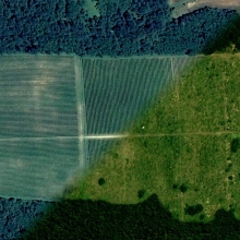
Vinohradníctvo je jednou z oblastí, kde sú pozemkové úpravy doslova jediným zmysluplným nástrojom na usporiadanie pozemkov, na ktorých sú vinohrady vysadené.
Rozpočet úřadu za rok 20
24.1.2017 8:52 ČÚZK /Urady/Katastralni-urady/Katastralni-urady/Katastralni-urad-pro-Plzensky-kraj/Rozpocet/2017Rozpočet úřadu za rok 20
24.1.2017 8:52 ČÚZK - předpisy a opatření Katastrální úřad pro Plzeňský krajvystavuje rozpočet úřadu za rok
2017
2017
24.1.2017 8:52 ČÚZK /Urady/Katastralni-urady/Katastralni-urady/Katastralni-urad-pro-Plzensky-kraj/Rozpocet/20172017
24.1.2017 8:52 ČÚZK - předpisy a opatření Katastrální úřad pro Plzeňský krajvystavuje rozpočet úřadu za rok
2017
2017
24.1.2017 8:52 ČÚZK - předpisy a opatření Katastrální úřad pro Plzeňský krajvystavuje rozpočet úřadu za rok
2017
Letošní první mapathon již příští týden v Praze
24.1.2017 8:35 GISportal.cz První letošní Missing maps mapathon v Praze, který se koná už za týden, 31. ledna od 18:30 do 21:00 v nově vzniklém coworkingovém prostoru Opero (Salvátorská 8, Praha 1) Registrace a víc informací? Budeme mapovat oblast okolo města ...2016
24.1.2017 7:57 ČÚZK /Urady/Zememericke-a-katastralni-inspektoraty/Zememericke-a-katastralni-inspektoraty/Zememericky-a-katastralni-inspektorat-v-Pardubicic/Vyrocni-zpravy/20162016
24.1.2017 7:57 ČÚZK - předpisy a opatření Zeměměřický a katastrální inspektorát v Pardubicíchvydává výroční zprávu úřadu za rok 2016
2016
Carlson Offers New Student Textbook and Software Bundle
24.1.2017 7:29 Carlson Software MAYSVILLE, Kentucky (January 24, 2017)— New for 2017, Carlson has announced a special student software and textbook bundle. Those enrolled in college or university within the engineering field will receive an office software license and option of, “A Practical Guide to Carlson Survey” or, “A Practical Guide to Carlson Fundamentals” for $99. Carlson offers diverse […]Elektřina
24.1.2017 1:00 Cenia - Katalog metadat ČR - INSPIRE Zásobování elektrickou energií na území hl. m. PrahyInformace ke Stahuj.gepro.cz
23.1.2017 19:32 GEPROSlužba Download (http://stahuj.gepro.cz), obsahující instalace našich produktů ke stažení, je aktuálně mimo provoz.… >>
Informace ke Stahuj.gepro.cz
23.1.2017 19:32 GEPROWebový server stahuj.gepro.cz, obsahující instalace našich produktů ke stažení. je aktuálně mimo provoz.… >>
Celofiremní setkání v Ledči nad Sázavou
23.1.2017 16:20 HrdličkaCelodenní program byl sestaven z řady odborně zaměřených workshopů, kterých se účastnily jednotlivé skupinky zaměstnanců podle typu jejich práce a zaměření. Výkonný ředitel Ing. Jan Floriánek k tomu dodává: „Letos jsme chtěli změnit podobu celofiremního školení tak, aby více vyhovovala profesním potřebám jednotlivých zaměstnanců. Byly zde workshopy orientované jak na geodézii, tak na GIS problematiku.... View Article
The post Celofiremní setkání v Ledči nad Sázavou appeared first on HRDLIČKA spol. s r.o. - komplexní služby v oblasti geodézie.
Inventarizace majetku pomocí online aplikace: zrychlete svou účetní závěrku!
23.1.2017 15:56 CleerioPříprava účetní závěrky je pro mnoho vlastníků pozemků noční můrou: ruční vypisování údajů o parcelách z jednotlivých listů vlastnictví je zdlouhavý proces, při kterém je snadné se dopustit chyb. Online aplikace Cleerio vám může usnadnit práci, ušetřit čas a výrazně tento proces zjednodušit.
Příspěvek Inventarizace majetku pomocí online aplikace: zrychlete svou účetní závěrku! pochází z Cleerio
Inventarizace majetku pomocí online aplikace: zrychlete svou účetní závěrku!
23.1.2017 15:56 Cleerio Příprava účetní závěrky je pro mnoho vlastníků pozemků noční můrou: ruční vypisování údajů o parcelách z jednotlivých listů vlastnictví je zdlouhavý proces, při kterém je snadné se dopustit chyb. Online aplikace Cleerio vám může usnadnit práci, ušetřit čas a výrazně tento proces zjednodušit.Inventarizace majetku pomocí online aplikace: zrychlete svou účetní závěrku!
23.1.2017 15:56 CleerioPříprava účetní závěrky je pro mnoho vlastníků pozemků noční můrou: ruční vypisování údajů o parcelách z jednotlivých listů vlastnictví je zdlouhavý proces, při kterém je snadné se dopustit chyb. Online aplikace Cleerio vám může usnadnit práci, ušetřit čas a výrazně tento proces zjednodušit.
Příspěvek Inventarizace majetku pomocí online aplikace: zrychlete svou účetní závěrku! pochází z CLEERIO
Inventarizace majetku pomocí online aplikace: zrychlete svou účetní závěrku!
23.1.2017 15:56 CleerioPříprava účetní závěrky je pro mnoho vlastníků pozemků noční můrou: ruční vypisování údajů o parcelách z jednotlivých listů vlastnictví je zdlouhavý proces, při kterém je snadné se dopustit chyb. Online aplikace Cleerio vám může usnadnit práci, ušetřit čas a výrazně tento proces zjednodušit.
Příspěvek Inventarizace majetku pomocí online aplikace: zrychlete svou účetní závěrku! pochází z Cleerio
Inventarizace majetku pomocí online aplikace: zrychlete svou účetní závěrku!
23.1.2017 15:56 Cleerio[…]
Příspěvek Inventarizace majetku pomocí online aplikace: zrychlete svou účetní závěrku! pochází z Cleerio
Odborný referent/ vrchní referent v oddělení aktualizace a dokumentace KN
23.1.2017 14:17 ČÚZK /Urady/Katastralni-urady/Katastralni-urady/Katastralni-urad-pro-Jihomoravsky-kraj/Volna-mista/Odborny-referent-vrchni-referent-v-oddeleni-aktualOdborný referent/ vrchní referent v oddělení aktualizace a dokumentace KN
23.1.2017 14:17 ČÚZK - předpisy a opatření Katastrální úřad pro Jihomoravský kraj Katastrální pracoviště Blanskovypisuje výběrové řízení na místo
Odborný referent/ vrchní referent v oddělení aktualizace a dokumentace KN
Odborný referent/ vrchní referent v oddělení aktualizace a dokumentace KN
23.1.2017 14:17 ČÚZK - volná místa Katastrální úřad pro Jihomoravský kraj, Katastrální pracoviště Blansko vypisuje výběrové řízení na místo Odborný referent/ vrchní referent v oddělení aktualizace a dokumentace KN2016
23.1.2017 12:55 ČÚZK /Urady/Zememericke-a-katastralni-inspektoraty/Zememericke-a-katastralni-inspektoraty/Zememericky-a-katastralni-inspektorat-v-Pardubicic/Casto-hledane-informace/Informace-o-vysledcich-kontrol-dle-§-26-zakona-c-2/20162016
23.1.2017 12:55 ČÚZK - předpisy a opatření Zeměměřický a katastrální inspektorát v Pardubicíchvydává výroční zprávu úřadu za rok 2016
2016
Další dvě nové pracovní nabídky v Praze
23.1.2017 12:17 GISportal.cz Společnost CEDA hledá Projektového manažera pro oblast GIS a dopravy a společnost AON hledá GIS EARTHQUAKE MODEL DEVELOPER.20170901-Omezení zápisu práv do dokončení OKO v k.ú. Lounky
23.1.2017 12:14 ČÚZK - předpisy a opatření Upozornění, že vzhledem k probíhající obnově katastrálního operátu v katastrálním území Lounky nelze v období od 9. 1. 2017 do vyhlášení platnosti obnoveného operátu provádět změny v zápisech vlastnických a jiných věcných práv do katastru nemovitostí k nemovitostem evidovaným v tomto katastrálním území. Všechna podání přijatá k zápisu do katastru nemovitostí budou muset vyčkat vyhlášení platnosti obnoveného operátu, jehož předpokládané datum je 13.2.201720170901-Omezení zápisu práv do dokončení OKO v k.ú. Lounky
23.1.2017 12:14 ČÚZK /Urady/Katastralni-urady/Katastralni-urady/Katastralni-urad-pro-Ustecky-kraj/Katastralni-pracoviste/KP-Litomerice/O-uradu/Aktuality/20170901-Omezeni-zapisu-prav-do-dokonceni-OKO-(1)20170901-Omezení zápisu práv do dokončení OKO v k.ú. Chodouny
23.1.2017 12:13 ČÚZK - předpisy a opatření Upozornění, že vzhledem k probíhající obnově katastrálního operátu v katastrálním území Chodouny nelze v období od 9. 1. 2017 do vyhlášení platnosti obnoveného operátu provádět změny v zápisech vlastnických a jiných věcných práv do katastru nemovitostí k nemovitostem evidovaným v tomto katastrálním území. Všechna podání přijatá k zápisu do katastru nemovitostí budou muset vyčkat vyhlášení platnosti obnoveného operátu, jehož předpokládané datum je 13.2.201720170901-Omezení zápisu práv do dokončení OKO v k.ú. Chodouny
23.1.2017 12:13 ČÚZK /Urady/Katastralni-urady/Katastralni-urady/Katastralni-urad-pro-Ustecky-kraj/Katastralni-pracoviste/KP-Litomerice/O-uradu/Aktuality/20170901-Omezeni-zapisu-prav-do-dokonceni-OKO-v-kV Geoportálu ÚAP Ústeckého kra
23.1.2017 12:00 Ústecký kraj V Geoportálu ÚAP Ústeckého kraje byla provedena aktualizace údajů pro poskytovatele Česká telekomunikační infrastruktura a.s. – jev 73, 81, 82přesun podatelny
23.1.2017 10:30 ČÚZK - předpisy a opatřeníDne 24.1.2017 je podatelna
z technických důvodů
přesunuta do II. patra č.dv.219
Správní poplatky je možno
hradit pouze v hotovosti nebo
kolkovými známkami
přesun podatelny
23.1.2017 10:30 ČÚZK /Urady/Katastralni-urady/Katastralni-urady/Katastralni-urad-pro-Plzensky-kraj/Katastralni-pracoviste/KP-Plzen-sever/O-uradu/Aktuality/presun-podatelnypřesun podatelny
23.1.2017 10:29 ČÚZK - předpisy a opatřeníDne 24.1.2017 je podatelna
z technických důvodů
přesunuta do II. patra č.dv.219
Správní poplatky je možno
hradit pouze v hotovosti nebo
kolkovými známkami
přesun podatelny
23.1.2017 10:29 ČÚZK /Urady/Katastralni-urady/Katastralni-urady/Katastralni-urad-pro-Plzensky-kraj/Katastralni-pracoviste/KP-Plzen-mesto/O-uradu/Aktuality/presun-podatelnyNové triky pro starou družici
23.1.2017 10:29 Český Kosmický PortálObservatoř XMM-Newton je jednou z nejdéle pracujících a nejproduktivnějších družic ESA: jejím úkolem je studovat vesmír v rentgenové části elektromagnetického spektra. Díky týmové práci a technickým inovacím je přitom pravděpodobné, že bude fungovat ještě dlouho.
Nové triky pro starou družici
23.1.2017 10:29 Český Kosmický PortálObservatoř XMM-Newton je jednou z nejdéle pracujících a nejproduktivnějších družic ESA: jejím úkolem je studovat vesmír v rentgenové části elektromagnetického spektra. Díky týmové práci a technickým inovacím je přitom pravděpodobné, že bude fungovat ještě dlouho.
Přesun podatelny
23.1.2017 10:25 ČÚZK - předpisy a opatřeníDne 24.1.2017 je podatelna
z technických důvodů
přesunuta do II. patra č.dv.219
Správní poplatky je možno
hradit pouze v hotovosti nebo
kolkovými známkami
Přesun podatelny
23.1.2017 10:25 ČÚZK /Urady/Katastralni-urady/Katastralni-urady/Katastralni-urad-pro-Plzensky-kraj/Katastralni-pracoviste/KP-Plzen-jih/O-uradu/Aktuality/Presun-podatelnyMáme nejnovější profesionální dron DJI Matrice 600 Pro
23.1.2017 9:53 UpVision Necelé dva týdny trvalo nahrazení naší odcizené oktokoptéry DJI S1000. Pod identickou registrační značkou OK-X005Y nyní létáme se zbrusu novou a mnohem výkonnější DJI Matrice 600 Pro, která je vybavena několikanásobnou redundancí avioniky a vyznačuje se úžasnými letovými vlastnostmi. V pátek na Letiště Medlánky - LKCM proběhlo přezkoušení od Úřadu pro civilní letectví.Zde několik fotek:
https://plus.google.com/+UpvisionCz1/posts/ZZRNcaMxgZK
Nová pracovní nabídka v Praze
23.1.2017 8:43 GISportal.cz Společnost Cleerio hledá GIS marketing specialistuNový mapový portál Středočeského kraje
23.1.2017 8:24 GISportal.cz Mapový portál obsahuje všechny mapové aplikace, které Středočeský kraj publikuje pro veřejnost. Mapové aplikace jsou prezentovány responzivní webovou aplikací MAPY a jsou tematicky zaměřené na životní prostředí, územní plánování, regionální rozvoj, dopravu a na další témata. Většina ...Katastrální mapa ve formátech DGN a DXF poskytovaná v e-shopu
23.1.2017 1:00 Cenia - Katalog metadat ČR - INSPIRE Katastrální mapa je závazným státním mapovým dílem velkého měřítka, obsahuje body polohového bodového pole, polohopis a popis. Katastrální mapa ve vektorové podobě je poskytována zdarma ve formátu DGN a DXF a obsahuje prvky Digitální katastrální mapy (DKM) a Katastrální mapy digitalizované (KMD), tedy bodová pole, budovy, další prvky mapy, hranice parcel, katastrální hranice, parcely katastru nemovitostí, prvky orientační mapy a hranice věcného břemene. Z důvodu použití formátu DGN produkt neobsahuje značky na liniích a oblouky jsou nahrazeny lomenými čárami. Katastrální mapa ve vektorové podobě k 23. 01. 2017 pokrývá 88,72% území České republiky, t.j. 69 967,56km2. Více katastrální vyhláška č.357/2013 Sb. v platném znění.INSPIRE téma Adresy (AD)
23.1.2017 1:00 Cenia - Katalog metadat ČR - INSPIRE Data odpovídají směrnici INSPIRE pro téma adresy (AD). Vychází především z projektu RÚIAN (Registr územní identifikace, adres a nemovitostí), který je součástí základních registrů České Republiky a obsahuje informace o územní identifikaci, adresách a nemovitostech. Data publikovaná v rámci INSPIRE obsahují pouze adresní místa a jejich komponenty, kterými jsou stát, obec, část obce, městský obvod v Praze (MOP), městký obvod/městská část (MO/MČ), ulice a pošta a to na území celé České Republiky. Obsahují rozvněž geometrii, která určuje definiční bod adresního místa. V datové sadě nění uvedeno 2,42%, t.j. 70262 adresních míst (k 23. 01. 2017), protože neobsahují definiční bod, podle kterého by je bylo možné prostorově určit. Více v zákoně č. 111/2009 Sb., o základních registrech a ve vyhlášce č. 359/2011 Sb., o základním registru územní identifikace, adres a nemovitostí v platných zněních a INSPIRE Data Specification on Addresses v 3.0.1 z 26.4.2010.INSPIRE téma Budovy (BU)
23.1.2017 1:00 Cenia - Katalog metadat ČR - INSPIRE Data odpovídají směrnici INSPIRE pro téma budovy (BU). Data pochází částečně z projektu RÚIAN (Registr územní identifikace, adres a nemovitostí), který je součástí základních registrů České Republiky a obsahuje informace o územní identifikaci, adresách a nemovitostech, a částečně z ISKN (Informační systém katastru nemovistostí). Zdrojem informací o budovách v ISKN je objekt Stavba, v RÚIAN je to Stavební objekt. Většina Staveb je zároveň Stavebními objekty, ale jsou případy, kdy tomu tak není. Kromě Budov datová sada obsahuje i části budov, které jsou pro potřeby INSPIRE vyjádřeny vchody z RÚIAN. Vchody obsahují informace o počtu podlaží, technickoekonomických atributech apod. Datová sada pokrývá celé území české republiky. V datové sadě není uvedeno 1,96%, t.j. 82353 budov (k 23. 01. 2017), protože neobsahují definiční bod ani polygon. Více v zákoně č. 111/2009 Sb., o základních registrech, ve vyhlášce č. 359/2011 Sb., o základním registru územní identifikace, adres a nemovitostí v platných zněních, v zákoně 256/2013 Sb., o katastru nemovitostí, v katastrální vyhlášce č. 357/2013 Sb. v platném znění a INSPIRE Data Specification on Buildings v 3.0 z 13.12.2013.Katastrální mapa v rastrové podobě poskytovaná v e-shopu
23.1.2017 1:00 Cenia - Katalog metadat ČR - INSPIRE Katastrální mapa v rastrové podobě je poskytována za úplatu a obsahuje analogovou mapu s kompletní kresbou. Analogová mapa pokrývá 7,95 % území České republiky, což je 6 269,65km2. Více katastrální vyhláška č.357/2013 Sb. v platném znění.Digitalizaci katastrální mapy (DG)
23.1.2017 1:00 Cenia - Katalog metadat ČR - INSPIRE Katastrální mapa je průběžně digitalizována. Část území je pokryta digitální katastrální mapou vzniklou na základě nového mapování, na části území jsou katatrální mapy digitalizované z map bývalého pozemkového katastru, z dekadického nebo sáhového měřítka a na části území je analogová mapa. Data popisují současný stav digitalizace jednotlivých katastrálních území včetně plánu digitalizace katastrálních území.INSPIRE téma Územní správní jednotky (AU)
23.1.2017 1:00 Cenia - Katalog metadat ČR - INSPIRE Data odpovídají směrnici INSPIRE pro téma Územní správní jednotky (AU) a datové specifikaci pro ELF ve verzi 1.0. Vychází především z projektu RÚIAN (Registr územní identifikace, adres a nemovitostí), který je součástí základních registrů České Republiky a obsahuje informace o územní identifikaci, adresách a nemovitostech. Data publikovaná v rámci INSPIRE harmonizované sady Územní správní jednotky obsahují pouze územní správní jednotky, jejich hranice a statistické jednotky NUTS1 a NUTS3, které jsou v rámci České republiky na stejné úrovni jako je stát a kraje. Územní správní jednotky jsou stát, kraje (vyšší územní samospravné celky), okresy a obce. Datová sada pokrývá celé území České republiky. Hranice územních samosprávných jednotek jsou vedeny od trojmezí do trojmezí na nejnižší úrovni členění, tedy obcí. Více v zákoně č. 111/2009 Sb., o základních registrech a ve vyhlášce č. 359/2011 Sb., o základním registru územní identifikace, adres a nemovitostí v platných zněních, INSPIRE Data Specification on Administrative Units v 3.0.1 z 26.4.2010 a ELF Data Specification v1.0. V datech chybí obec Strýčice, protože nemá žádné katastrální území.INSPIRE téma Parcely (CP)
23.1.2017 1:00 Cenia - Katalog metadat ČR - INSPIRE Data odpovídají směrnici INSPIRE pro téma katastrální parcely (CP). Vychází z katastrální mapy, která je závazným státním mapovým dílem velkého měřítka, obsahuje body polohového bodového pole, polohopis a popis a může mít formu digitální mapy, analogové mapy nebo digitalizované mapy. Data publikovaná v rámci INSPIRE obsahují pouze katastrální území (pro celou Českou Republiku) a parcely a jejich hranice z území, kde je digitální mapa (k 23. 01. 2017 je to 88,72% území České republiky, t.j. 69 967,56km2). Více katastrální zákon 344/1992 SB., katastrální vyhláška č.26/2007 Sb. v platném znění a INSPIRE Data Specification on Cadastral Parcels v 3.0.1.Úvodní jednání o zahájení řízení komplexních pozemkových úprav v k. ú. Škrle, okres Chomutov
23.1.2017 0:00 Státní pozemkový úřad Krajský pozemkový úřad pro Ústecký kraj, Pobočka Chomutov zahájil řízení o komplexních pozemkových úpravách v katastrálním území Škrle. Úvodní jednání se uskuteční dne 1. února 2017 v 16.00 hodin na zámečku ve Škrlích (prezence od 15:30 hodin).Ohlédnutí za konferencí GIS Esri v ČR 2017
22.1.2017 7:00 Česká asociace pro geoinformace Na oficiálních webových stránkách konference GIS Esri v ČR naleznete ohlédnutí organizátorů za letošním ročníkem. Můžete si projít galerii fotografií, videozáznamy přednášek, prezentace a náhledy posterů. Zveřejněny jsou rovněř výsledky jednotlivýchKonference Inspirujme se ... udržitelností
21.1.2017 7:00 Česká asociace pro geoinformace CENIA, česká informační agentura životního prostředí a Slovenská agentúra životného prostredia Vás srdečně zvou na 5. ročník česko-slovenské konference INSPIRUJME SE… udržitelností, která je letos spojena s úvodní konferencí projektu ATTRACTIVE DANUBE, realizovaného v rámci programu INTERREG DANUBE.Letošní konference Inspirujme se…udržitelností má za cíl
vrchní referent/rada – zápisy řízení V a Z Katastrálního pracoviště Ostrava, Katastrálního úřadu pro
20.1.2017 12:51 ČÚZK - předpisy a opatření Katastrální úřad pro Moravskoslezský kraj Katastrální pracoviště Ostravavypisuje výběrové řízení na místo vrchní referent/rada – zápisy řízení V a Z KP Ostrava
vrchní referent/rada – zápisy řízení V a Z Katastrálního pracoviště Ostrava, Katastrálního úřadu pro Moravskoslezský kraj
vrchní referent/rada – zápisy řízení V a Z Katastrálního pracoviště Ostrava, Katastrálního úřadu pro
20.1.2017 12:51 ČÚZK - volná místa Katastrální úřad pro Moravskoslezský kraj, Katastrální pracoviště Ostrava vypisuje výběrové řízení na místo vrchní referent/rada – zápisy řízení V a Z Katastrálního pracoviště Ostrava, Katastrálního úřadu provrchní referent/rada – zápisy řízení V a Z Katastrálního pracoviště Ostrava, Katastrálního úřadu pro
20.1.2017 12:51 ČÚZK /Urady/Katastralni-urady/Katastralni-urady/Katastralni-urad-pro-Moravskoslezsky-kraj/Uredni-deska/Oznameni-a-jina-uredni-sdeleni/Volna-mista/vrchni-referent-rada-–-zapisy-rizeni-V-a-Z-Katastr2016
20.1.2017 11:22 ČÚZK /Urady/Zememericke-a-katastralni-inspektoraty/Zememericke-a-katastralni-inspektoraty/Zememericky-a-katastralni-inspektorat-v-Praze/Casto-hledane-informace/Informace-o-vysledcich-kontrol-dle-§-26-zakona-c-2/20162016
20.1.2017 11:22 ČÚZK - předpisy a opatření Zeměměřický a katastrální inspektorát v Prazevydává výroční zprávu úřadu za rok
2016
2016
20.1.2017 11:22 ČÚZK - předpisy a opatření Zeměměřický a katastrální inspektorát v Prazevydává výroční zprávu úřadu za rok
2016
2016
20.1.2017 11:22 ČÚZK /Urady/Zememericke-a-katastralni-inspektoraty/Zememericke-a-katastralni-inspektoraty/Zememericky-a-katastralni-inspektorat-v-Praze/Vyrocni-zpravy/2016Zveřejnění obsahu informací poskytnutých na žádost dle zákona č. 106/1999 Sb. za rok 2017
20.1.2017 11:21 ČÚZK - předpisy a opatření Zeměměřický a katastrální inspektorát v Prazezveřejňuje obsah informace poskytnutých na žádost dle zákona č. 106/1999 Sb. za rok
2017
2017
20.1.2017 11:21 ČÚZK - předpisy a opatření Zeměměřický a katastrální inspektorát v Prazezveřejňuje obsah informace poskytnutých na žádost dle zákona č. 106/1999 Sb. za rok
2017
Zveřejnění obsahu informací poskytnutých na žádost dle zákona č. 106/1999 Sb. za rok 2017
20.1.2017 11:21 ČÚZK /Urady/Zememericke-a-katastralni-inspektoraty/Zememericke-a-katastralni-inspektoraty/Zememericky-a-katastralni-inspektorat-v-Praze/Casto-hledane-informace/Poskytovani-informaci-106-1999-Sb/Zverejneni-obsahu-informaci-poskytnutych-na-za-(1)/20172017
20.1.2017 11:21 ČÚZK /Urady/Zememericke-a-katastralni-inspektoraty/Zememericke-a-katastralni-inspektoraty/Zememericky-a-katastralni-inspektorat-v-Praze/Casto-hledane-informace/Poskytovani-informaci-106-1999-Sb/Zverejneni-obsahu-informaci-poskytnutych-na-za-(1)/2017Spuštěn mapový portál Středočeského kraje
20.1.2017 11:15 Středočeský kraj Mapový portál obsahuje všechny mapové aplikace, které Středočeský kraj publikuje pro veřejnost. Mapové aplikace jsou prezentovány responzivní webovou aplikací MAPY a jsou tematicky zaměřené na životní prostředí, územní plánování, regionální rozvoj, dopravu a na další témata. Většina mapových aplikací Středočeského kraje je zpracována vlastními silami, některé aplikace jsou zpracovány dodavatelsky. Aplikace zpracované vlastními silami jsou označeny ikonami JS nebo FX, přičemž každá z těchto aplikací obsahuje stručný popis, dobu vzniku, informaci o aktualizaci, kontakt a odkaz na další informace.Mapové aplikace označené ikonou JS jsou zpracované ve Web App Builder for ArcGIS DE.
Mapový portál veřejnosti zároveň nabízí i responzivní webovou aplikaci ODKAZY, která zprostředkovává mapové aplikace (nebo statické mapy) jiných poskytovatelů. Webové aplikace MAPY a ODKAZY byly vytvořeny pomocí šablony Maps and Apps Gallery – ArcGIS.
Mapový portál také poskytuje AKTUALITY a INFORMACE. Cílem Aktualit je informovat veřejnost o novinkách GIS Středočeského kraje, zatímco webová stránka Informace obsahuje základní informace o činnosti GIS Středočeského kraje, o využívané technologii GIS Středočeského kraje a o uplatnění GIS v legislativě. Stránka vyhrazená pro GIS Středočeského kraje obsahuje i nové základní odkazy Mapové aplikace, Mapy ke stažení a související odkazy na Mapové portály ORP, Odbor životního prostředí – GIS.
Komplexné, komasačné a jednoduché pozemkové úpravy.
20.1.2017 10:11 Komora pozemkových úprav SR
Návrh riešenia usporiadania pozemkového vlastníctva v SR, ktorý KPÚ SR poskytla Združeniu miest a obcí Slovenska.
Big Island
20.1.2017 10:05 ESA Observing the Earth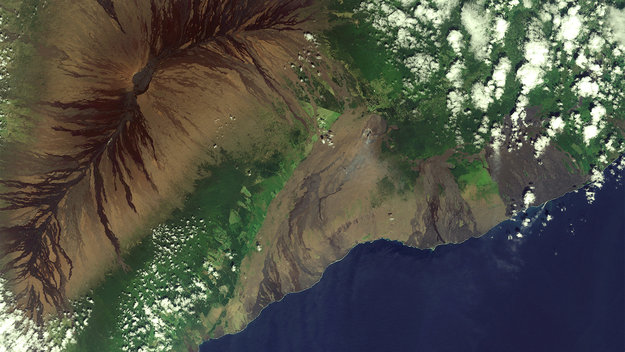
Earth observation image of the week: a Sentinel-2 image of Hawaii's Big Island, also featured on the Earth from Space video programme