


![]()

zprávy
zdroje zpráv:Referent KN – návrh zápisu v katastru
10.2.2017 13:47 ČÚZK - volná místa Katastrální úřad pro hlavní město Prahu, Katastrální pracoviště Praha vypisuje výběrové řízení na místo Referent KN – návrh zápisu v katastruISKN Studio pro ArcGIS 10.5
10.2.2017 13:24 ARCDATAK dispozici je nová verze aplikace ISKN Studio, která podporuje aktuální verzi systému ArcGIS 10.5. Více informací o funkcích a vlastnostech softwaru ISKN Studio naleznete na samostatné stránce.

vrchní referent/rada – obnova katastrálního operátu v Technickém odboru Katastrálního úřadu pro Mora
10.2.2017 13:16 ČÚZK - volná místa Katastrální úřad pro Moravskoslezský kraj, vypisuje výběrové řízení na místo vrchní referent/rada – obnova katastrálního operátu v Technickém odboru Katastrálního úřadu pro Moravrchní referent/rada – obnova katastrálního operátu v Technickém odboru Katastrálního úřadu pro Mora
10.2.2017 13:16 ČÚZK /Urady/Katastralni-urady/Katastralni-urady/Katastralni-urad-pro-Moravskoslezsky-kraj/Uredni-deska/Oznameni-a-jina-uredni-sdeleni/Volna-mista/vrchni-referent-rada-–-obnova-katastralniho-op-(1)vrchní referent/rada – obnova katastrálního operátu v Technickém odboru Katastrálního úřadu pro Mora
10.2.2017 13:16 ČÚZK - předpisy a opatření Katastrální úřad pro Moravskoslezský krajvypisuje výběrové řízení na místo vrchní referent/rada – obnova kat. operátu v TO KÚ pro MS kraj
vrchní referent/rada – obnova katastrálního operátu v Technickém odboru Katastrálního úřadu pro Moravskoslezský kraj
rada/odborný rada – rozhodování o povolení vkladu Katastrálního pracoviště Opava, Katastrálního úřad
10.2.2017 13:12 ČÚZK - volná místa Katastrální úřad pro Moravskoslezský kraj, Katastrální pracoviště Opava vypisuje výběrové řízení na místo rada/odborný rada – rozhodování o povolení vkladu Katastrálního pracoviště Opava, Katastrálního úřadrada/odborný rada – rozhodování o povolení vkladu Katastrálního pracoviště Opava, Katastrálního úřad
10.2.2017 13:12 ČÚZK - předpisy a opatření Katastrální úřad pro Moravskoslezský kraj Katastrální pracoviště Opavavypisuje výběrové řízení na místo rada/odborný rada – rozhodování o povolení vkladu KP Opava
rada/odborný rada – rozhodování o povolení vkladu Katastrálního pracoviště Opava, Katastrálního úřadu pro Moravskoslezský kraj
rada/odborný rada – rozhodování o povolení vkladu Katastrálního pracoviště Opava, Katastrálního úřad
10.2.2017 13:12 ČÚZK /Urady/Katastralni-urady/Katastralni-urady/Katastralni-urad-pro-Moravskoslezsky-kraj/Uredni-deska/Oznameni-a-jina-uredni-sdeleni/Volna-mista/rada-odborny-rada-–-rozhodovani-o-povoleni-vkladuodborný referent/vrchní referent – poskytování informací KN Katastrálního pracoviště Opava, Katastrá
10.2.2017 13:10 ČÚZK - předpisy a opatření Katastrální úřad pro Moravskoslezský kraj Katastrální pracoviště Opavavypisuje výběrové řízení na místo odborný referent/vrchní referent – poskytování informací KP Opava
odborný referent/vrchní referent – poskytování informací KN Katastrálního pracoviště Opava, Katastrálního úřadu pro Moravskoslezský kraj
odborný referent/vrchní referent – poskytování informací KN Katastrálního pracoviště Opava, Katastrá
10.2.2017 13:10 ČÚZK /Urady/Katastralni-urady/Katastralni-urady/Katastralni-urad-pro-Moravskoslezsky-kraj/Uredni-deska/Oznameni-a-jina-uredni-sdeleni/Volna-mista/odborny-referent-vrchni-referent-–-poskytovani-(1)odborný referent/vrchní referent – poskytování informací KN Katastrálního pracoviště Opava, Katastrá
10.2.2017 13:10 ČÚZK - volná místa Katastrální úřad pro Moravskoslezský kraj, Katastrální pracoviště Opava vypisuje výběrové řízení na místo odborný referent/vrchní referent – poskytování informací KN Katastrálního pracoviště Opava, KatastráMapová aplikace Zastavěné územ
10.2.2017 12:00 Jihočeský kraj Mapová aplikace Zastavěné území byla aktualizována k 10.2.2017.Mapová aplikace byla aktualiz
10.2.2017 12:00 Jihočeský kraj Mapová aplikace byla aktualizována k 10.2.2017.V seznamu mapových služeb obla
10.2.2017 12:00 Plzeňský kraj V seznamu mapových služeb oblasti Doprava a silniční hospodářství (http://geoportal.plzensky-kraj.cz/gs/doprava-a-silnicni-hospodastvi) byla publikováno nová mapová služba Akce SÚS PK - vodorovné dopravní značení 2016 (http://mapy.kr-plzensky.cz/gis/suspk_vdz). Mapa zobrazuje silnice a komunikace, na nichž Správa a údržba silnic Plzeňského kraje (SÚS PK) v roce 2016 prováděla zákres (obnovu) vodorovného dopravního značení (VDZ). Po kliknutí na patřičný silniční úsek se vypíší podrobné údaje o zákresu VDZ. Podkladová data poskytla přímo SÚS PK.V seznamu mapových služeb obla
10.2.2017 12:00 Plzeňský kraj V seznamu mapových služeb oblasti Doprava a silniční hospodářství byla publikováno nová mapová služba Akce SÚS PK - vodorovné dopravní značení 2016. Mapa zobrazuje silnice a komunikace, na nichž Správa a údržba silnic Plzeňského kraje (SÚS PK) v roce 2016 prováděla zákres (obnovu) vodorovného dopravního značení (VDZ). Po kliknutí na patřičný silniční úsek se vypíší podrobné údaje o zákresu VDZ. Podkladová data poskytla přímo SÚS PK.Farmáři těží ze spolupráce ESA a BASF
10.2.2017 11:23 Český Kosmický PortálProtože zemědělství je náročný obor, tak ESA a světová vůdčí chemická společnost BASF spojily síly, aby zjistily, jak data z družic mohou nejlépe pomoci právě zemědělské komunitě.
Farmáři těží ze spolupráce ESA a BASF
10.2.2017 11:23 Český Kosmický PortálProtože zemědělství je náročný obor, tak ESA a světová vůdčí chemická společnost BASF spojily síly, aby zjistily, jak data z družic mohou nejlépe pomoci právě zemědělské komunitě.
Nová verze nástroje VFR Import
10.2.2017 10:55 ARCDATAAktuální verze nástroje VFR Import pracuje s daty RÚIAN verze 2.1 a podporuje ArcGIS Desktop 10.5. Podrobný popis funkčnosti nástroje VFR Import naleznete na samostatné stránce, kde si můžete zdarma stáhnout verzi VFR Import Basic.

Sicilian snow
10.2.2017 10:05 ESA Observing the Earth
Earth observation image of the week: rare snow cover on the Italian island of Sicily, also featured on the Earth from Space video programme
Galileo Commercial Service Implementing Decision enters into force
10.2.2017 10:03 European GNSS Agency
The European Commission and the European GNSS Agency (GSA) confirm that the first generation of Galileo will already provide users with High Accuracy and Authentication services.
Welcoming the adoption of the Galileo Commercial Service Implementing Decision, the European Commission and the GSA confirm that the first generation of Galileo will provide users with High Accuracy and Authentication services. The Commercial Service will complement the Galileo Open Service by providing an additional navigation signal and added-value services in a different frequency band. Unlike the Open Service, the Commercial Service signal can be encrypted in order to control access to Galileo Commercial Services.
“The Commercial Service is unique in that its services are not provided by any other GNSS programme and thus represents a unique opportunity for Galileo to differentiate itself from other systems and offer users an added value to the standard positioning services already available,” says GSA Executive Director Carlo des Dorides.
With the Commercial Service, Galileo users will benefit from:
- a High Accuracy service based on the transmission of Precise Point Positioning (PPP) information through its E6-B signal, delivering accuracy below one decimetre worldwide; and
- a Commercial Authentication service based on the E6 signal code encryption, allowing for increased robustness of professional applications.
Following the Commercial Service Implementing Decision, the user community will also be able to use the Open Service Navigation Message Authentication (OS NMA) for free. The OS NMA is capable of protecting users from spoofing attacks by digitally signing the Open Service message in the E1 band.
“Galileo’s High Accuracy and Authentication services, including NMA, take advantage of already existing infrastructure,” explains European Commission Galileo Commercial Service Manager Ignacio Fernández Hernández. “This is why they can be provided in a timely and cost-effective manner, yet with very good performance.”
It is foreseen that the High Accuracy and Commercial Authentication services will be provided for a fee, and that at least one signal component of the Galileo E6 signals remains freely available, allowing user communities to benefit from signals in all Galileo bands.
To avoid disrupting existing professional markets, it is planned that the Commercial Service will be operated by at least one yet-to-be-determined commercial service provider. All three services are compatible with the current signal definition and are based on existing infrastructure.
After a test period, the Galileo Commercial Service will become available when Galileo reaches Full Operational Capability (FOC), which is expected by 2020. It will complement the Galileo Open Service, Public Regulated Service (PRS) and Search and Rescue (SAR) service – all available now via the Galileo Initial Services. Additional satellites will be successively added to the constellation, with the launch of the next four foreseen in 2017.
Media note: This feature can be republished without charge provided the European GNSS Agency (GSA) is acknowledged as the source at the top or the bottom of the story. You must request permission before you use any of the photographs on the site. If you republish, we would be grateful if you could link back to the GSA website (http://www.gsa.europa.eu).
GSA scholarship asks next generation of GNSS users to share their vision for the future
10.2.2017 9:51 European GNSS Agency
The European GNSS Agency (GSA), in cooperation with the Space Generation Advisory Council (SGAC), launches the Young GSA – New Navigation Horizons Scholarship.
The Young GSA – New Navigation Horizons Scholarship, a joint initiative of the European GNSS Agency (GSA) and the Space Generation Advisory Council (SGAC), asks European students and young professionals to share their views on what Galileo means for society, business and European integration.
To participate, all you have to do is create a 30-second video and write a 400-word essay answering one of the following questions:
- With the introduction of Galileo, the idea of a multi-constellation environment has become a reality. With more global navigation satellite system (GNSS) satellites in orbit, users are now benefiting from better positioning and navigation accuracy than ever before. How can these benefits be harnessed in the future?
- How can Europe’s space programmes – Galileo, EGNOS and Copernicus – strengthen the European Union?
The winner will receive up to USD 2 000 that can be used to attend both the 6th Space Generation Fusion Forum and the 33rd Space Symposium, scheduled for 2 to 6 April 2017 in Colorado Springs, Colorado, USA.
The details
The scholarship is open to European students and young professionals aged 18 to 35. In order to participate, one must be a registered SGAC member. You can register for a free membership here.
In addition to the video and essay, applicants must also submit their CV (with date of birth and country of citizenship). All submissions must be in English and must be received via the Scholarship's Submission Form no later than 23.59 GMT on 26 February 2017.
More information can be found here.
The SGAC is dedicated to bringing together university students and young professionals to think creatively about international, national and local space policy issues. Its objective is to inject the next generation’s point-of-view into the space policy of tomorrow.
Media note: This feature can be republished without charge provided the European GNSS Agency (GSA) is acknowledged as the source at the top or the bottom of the story. You must request permission before you use any of the photographs on the site. If you republish, we would be grateful if you could link back to the GSA website (http://www.gsa.europa.eu).
V britském časopisu Civil Engineering Surveyor náš článek o monitoringu drony skrytých vad
10.2.2017 8:53 UpVision V únorovém čísle britského časopisu Civil Engineering Surveyor vyšel náš článek o možnostech leteckého monitoringu a identifikace skrytých poškození v různých konstrukcích z dronů.Více zde:
https://plus.google.com/+UpvisionCz1/posts/JVJFFCjoiqu
Data o Praze přehledně. Vznikl Katalog městských částí (TZ)
10.2.2017 8:20 GISportal.cz Institut plánování a rozvoje Prahy (IPR Praha) spouští webové stránky katalog-mc.iprpraha.cz, kde jsou k nalezení nejrůznější číselné informace o všech z padesáti sedmi městských částí i o Praze jako celku. Data se týkají například ekonomiky, školství, ale ...Konfernce IGDA 2018
10.2.2017 7:00 Česká asociace pro geoinformace Od 20. do 22. dubna 2018 se bude v Praze konat Mezinárodní konference o geoinformatice a analýze dat. Konferenci organizuje Mezinárodní akademie výpočetní techniky (IACT).Cílem konference je sdílení znalostí, spolupráce a prezentace výsledků výzkumu mezi akademiky, vědci a další odbornou veřejností v oblasti geoinformatiky a analýzy dat. Součástí konference budou
REFERENT KN – obnova katastrálního operátu
9.2.2017 15:28 ČÚZK /Urady/Katastralni-urady/Katastralni-urady/Katastralni-urad-pro-hlavni-mesto-Prahu/O-uradu/Aktuality/REFERENT-KN-–-obnova-katastralniho-operatuREFERENT KN – obnova katastrálního operátu
9.2.2017 15:28 ČÚZK - předpisy a opatření Nově vyhlášené výběrové řízení na služení místoREFERENT KN – obnova katastrálního operátu
REFERENT KN – obnova katastrálního operátu
9.2.2017 15:28 ČÚZK - předpisy a opatření Nově vyhlášené výběrové řízení na služení místo:REFERENT KN – obnova katastrálního operátu
REFERENT KN – obnova katastrálního operátu
9.2.2017 15:28 ČÚZK - předpisy a opatření Nově vyhlášené výběrové řízení na služení místo:Referent KN – obnova katastrálního operátu
REFERENT KN – obnova katastrálního operátu
9.2.2017 15:19 ČÚZK - předpisy a opatření Katastrální úřad pro hlavní město Prahu Katastrální pracoviště Prahavypisuje výběrové řízení na místo
REFERENT KN – obnova katastrálního operátu
REFERENT KN – obnova katastrálního operátu
9.2.2017 15:19 ČÚZK - volná místa Katastrální úřad pro hlavní město Prahu, Katastrální pracoviště Praha vypisuje výběrové řízení na místo REFERENT KN – obnova katastrálního operátuREFERENT KN – obnova katastrálního operátu
9.2.2017 15:19 ČÚZK /Urady/Katastralni-urady/Katastralni-urady/Katastralni-urad-pro-hlavni-mesto-Prahu/Uredni-deska/Oznameni-a-jina-uredni-sdeleni/Volna-mista/REFERENT-KN-–-obnova-katastralniho-operatuEarth from Space
9.2.2017 14:15 ESA Observing the Earth
Join us Friday, 10 February, at 10:00 CET for the ‘Earth from Space’ video programme. This week features rare snow cover on the Italian island of Sicily
Referent KN – právník, PT 12
9.2.2017 11:24 ČÚZK - předpisy a opatření Nově vyhlášené výběrové řízení na služební místo:Referent KN – právník, PT 12
Referent KN – návrh zápisu, kontrola a zplatnění
9.2.2017 11:24 ČÚZK - předpisy a opatření Nově vyhlášené výběrové řízení na služební místo:Referent KN – návrh zápisu, kontrola a zplatnění
Referent KN – návrh zápisu, kontrola a zplatnění
9.2.2017 11:24 ČÚZK /Urady/Katastralni-urady/Katastralni-urady/Katastralni-urad-pro-hlavni-mesto-Prahu/O-uradu/Aktuality/Referent-KN-–-pravnik,-PT-12Referent KN – právník, PT 12
9.2.2017 11:24 ČÚZK /Urady/Katastralni-urady/Katastralni-urady/Katastralni-urad-pro-hlavni-mesto-Prahu/O-uradu/Aktuality/Referent-KN-–-pravnik,-PT-12Družice CryoSat odhalila odtok ledovců pod ledem v Antarktidě
9.2.2017 11:22 Český Kosmický PortálInovativní způsob využití mise ESA CryoSat ukázal, jak jezera pod ledovcem Thwaites odtékají do Amundsenova moře. Jde o největší kdy zaznamenaný odtok v oblasti západní Antarktidy.
Družice CryoSat odhalila odtok ledovců pod ledem v Antarktidě
9.2.2017 11:22 Český Kosmický PortálInovativní způsob využití mise ESA CryoSat ukázal, jak jezera pod ledovcem Thwaites odtékají do Amundsenova moře. Jde o největší kdy zaznamenaný odtok v oblasti západní Antarktidy.
Hledáme: Řidič – operátor systému mobilního mapování
9.2.2017 11:04 TopGis Společnost TopGis, s.r.o. vypisuje výběrové řízení na pozici „Řidič – operátor systému mobilního mapování“ na DPP nebo DPČ na dobu určitou 03/2017 – 10/2017. Pracovní náplň: Požadavky: Pracoviště: Pracovní poměr formou DPP na dobu určitou 03/2017 – 10/2017. V případě Vašeho zájmu nám pošlete Váš strukturovaný životopis na emailovou adresu kariera@topgis.cz. Odpovědí na inzerát či zaslánímReferent KN – právník, PT 12
9.2.2017 10:29 ČÚZK /Urady/Katastralni-urady/Katastralni-urady/Katastralni-urad-pro-hlavni-mesto-Prahu/Katastralni-pracoviste/KP-Praha/O-uradu/Aktuality/Referent-KN-–-pravnik,-PT-12Referent KN – právník, PT 12
9.2.2017 10:29 ČÚZK - předpisy a opatření Nově vyhlášená výběrová řízení na služební místo:Referent KN – právník, PT 12
Referent KN – právník, PT 12
9.2.2017 10:13 ČÚZK - předpisy a opatření Katastrální úřad pro hlavní město Prahu Katastrální pracoviště Prahavypisuje výběrové řízení na místo
Referent KN – právník, PT 12
Referent KN – právník, PT 12
9.2.2017 10:13 ČÚZK /Urady/Katastralni-urady/Katastralni-urady/Katastralni-urad-pro-hlavni-mesto-Prahu/Uredni-deska/Oznameni-a-jina-uredni-sdeleni/Volna-mista/Referent-KN-–-pravnik,-PT-12Referent KN – právník, PT 12
9.2.2017 10:13 ČÚZK - volná místa Katastrální úřad pro hlavní město Prahu, Katastrální pracoviště Praha vypisuje výběrové řízení na místo Referent KN – právník, PT 12Referent katastru nemovitostí v oddělení právních vztahů k nemovitostem Katastrálního pracoviště Pís
9.2.2017 10:00 ČÚZK - předpisy a opatření Katastrální úřad pro Jihočeský kraj Katastrální pracoviště Písekvypisuje výběrové řízení na místo
Referent katastru nemovitostí v oddělení právních vztahů k nemovitostem Katastrálního pracoviště Písek
Referent katastru nemovitostí v oddělení právních vztahů k nemovitostem Katastrálního pracoviště Pís
9.2.2017 10:00 ČÚZK - volná místa Katastrální úřad pro Jihočeský kraj, Katastrální pracoviště Písek vypisuje výběrové řízení na místo Referent katastru nemovitostí v oddělení právních vztahů k nemovitostem Katastrálního pracoviště PísReferent katastru nemovitostí v oddělení právních vztahů k nemovitostem Katastrálního pracoviště Pís
9.2.2017 10:00 ČÚZK /Urady/Katastralni-urady/Katastralni-urady/Katastralni-urad-pro-Jihocesky-kraj/Volna-mista/Referent-katastru-nemovitosti-v-oddeleni-pravnichMožnosti hodnocení kvality VGI se zaměřením na humanitární mapování
9.2.2017 9:46 GISportal.cz V červenci 2004 vytvořil Steve Coast projekt Open Street Map, se snahou zmapovat celý svět vytvořením platformy pro volné sdílení VGI (volunteered geographic information). Projekt sám ale nedokázal pokrýt poptávku, hlavně v rozvojových zemích, kde není mnohdy ...20170209-VŔ Analytik - programátor
9.2.2017 9:39 ČÚZK /Aktuality-resort/2017/20170209-VR-Analytik-programator20170209-VŔ Analytik - programátor
9.2.2017 9:39 ČÚZK - předpisy a opatření Oznámení o vyhlášení výběrového řízení na služební místo analytik - programátor - informace zde.Analytik -- programátor
9.2.2017 9:35 ČÚZK /Urady/Cesky-urad-zememericky-a-katastralni/Uredni-deska/Oznameni-a-jina-uredni-sdeleni/Volna-mista/Analytik-programator-(1)Analytik -- programátor
9.2.2017 9:35 ČÚZK - volná místa Český úřad zeměměřický a katastrální, vypisuje výběrové řízení na místo Analytik -- programátorAnalytik -- programátor
9.2.2017 9:35 ČÚZK - předpisy a opatření Český úřad zeměměřický a katastrálnívypisuje výběrové řízení na místo
Analytik -- programátor
Výběrové řízení na zahraniční mobility 2017/18 - update
9.2.2017 8:45 Katedra geografie UP Olomouc Díky podpisu smlouvy z tohoto týdne mohla být nabídka zahraničních univerzit pro stávající výběrové řízení rozšířena o Univerzitu v Novem Sadu (Srbsko). V aplikaci erasmusplus.upol.cz byl zřízen nový odkaz na speciální výběrové řízení.20170209-VŘ Metodika KN - správa a vedení
9.2.2017 8:39 ČÚZK - předpisy a opatření Oznámení o vyhlášení výběrového řízení na služební místo Metodika KN - správa a vedení - informace zde.20170209-VŘ Metodika KN - správa a vedení
9.2.2017 8:39 ČÚZK /Aktuality-resort/2017/20170209-VR-Metodika-KN-sprava-a-vedeniCryoSat reveals lake outbursts beneath Antarctic ice
8.2.2017 15:30 ESA Observing the Earth
A novel way of using ESA’s CryoSat mission has revealed how lakes beneath Thwaites Glacier drained into the Amundsen Sea – potentially the largest such outflow ever reported in this region of West Antarctica.
Katalog MČ
8.2.2017 14:39 Geoportál PrahaKatalog číselných údajů pro jednotlivé městské části najdete v nové aplikaci Katalog městských částí.
V seznamu mapových služeb obla
8.2.2017 12:00 Plzeňský kraj V seznamu mapových služeb oblasti Doprava a silniční hospodářství (http://geoportal.plzensky-kraj.cz/gs/doprava-a-silnicni-hospodastvi//) byl aktualizován obsah mapové služby Stavební akce na silnicích PK v letech 2014 až 2017 (http://tinyurl.com/qcozxw6). Z dat dodaných SÚS PK byly doplněny vrstvy Stavebních akcí 2017 i 2014. Stavební akce roku 2017 budou průběžně doplňovány a aktualizovány. Aplikace je optimalizovaná pro používání v mobilních zařízeních.V seznamu mapových služeb obla
8.2.2017 12:00 Plzeňský kraj V seznamu mapových služeb oblasti Doprava a silniční hospodářství byl aktualizován obsah mapové služby Stavební akce na silnicích PK v letech 2014 až 2017. Z dat dodaných SÚS PK byly doplněny vrstvy Stavebních akcí 2017 i 2014. Stavební akce roku 2017 budou průběžně doplňovány a aktualizovány. Aplikace je optimalizovaná pro používání v mobilních zařízeních.Prchavé elektrické výboje potvrzeny z paluby ISS
8.2.2017 11:20 Český Kosmický PortálJejich existence byla roky předmětem debat: prchavé elektrické výboje v horních vrstvách atmosféry s až pohádkovými názvy jako červení skřítkové, modré výtrysky, trpaslíci nebo elfové. Hlásili je piloti letadel, ale bylo obtížné je studovat, protože vznikaly nad bouřemi.
Prchavé elektrické výboje potvrzeny z paluby ISS
8.2.2017 11:20 Český Kosmický PortálJejich existence byla roky předmětem debat: prchavé elektrické výboje v horních vrstvách atmosféry s až pohádkovými názvy jako červení skřítkové, modré výtrysky, trpaslíci nebo elfové. Hlásili je piloti letadel, ale bylo obtížné je studovat, protože vznikaly nad bouřemi.
Northern exposure for satnav summer school
8.2.2017 10:37 ESA Navigation
This year’s ESA–Joint Research Centre International Summer School on Global Navigation Satellite Systems will be held in Longyearbyen, Svalbard-Spitsbergen, Norway, on 4–15 September, close to the world's northernmost Galileo station.
Registrace na 22. kartografickou konferenci spuštěna + soutěž o studentské vstupné zdarma.
8.2.2017 8:37 GISportal.cz Pokud plánujete svoji účast na 22. kartografické konferenci, která se letos koná v Liberci, tak se již můžete registrovat. Jako na každé konferenci, ti kteří se příhlásí dříve, platí nižší vložné, které i tak není ...Druhá ztráta v jednom týdnu – zemřel Hans Rosling
8.2.2017 8:21 GISportal.cz Po smutné zprávě o úmrtí profesora Demka přinášíme další nekrolog a to švédského profesora statistiky a medicíny Hanse Roslinga, který zemřel včera (7. února). Pokdu si říkáte, že vám jeho jméno nic neříká, možná budete znát ...potvrzovatel geometrických plánů na Katastrálním pracovišti Chrudim
8.2.2017 7:03 ČÚZK /Urady/Katastralni-urady/Katastralni-urady/Katastralni-urad-pro-Pardubicky-kraj/Volna-mista/potvrzovatel-geometrickych-planu-na-Katastralnim-ppotvrzovatel geometrických plánů na Katastrálním pracovišti Chrudim
8.2.2017 7:03 ČÚZK - předpisy a opatření Katastrální úřad pro Pardubický kraj Katastrální pracoviště Chrudimvypisuje výběrové řízení na místo
potvrzovatel geometrických plánů na Katastrálním pracovišti Chrudim
potvrzovatel geometrických plánů na Katastrálním pracovišti Chrudim
8.2.2017 7:03 ČÚZK - volná místa Katastrální úřad pro Pardubický kraj, Katastrální pracoviště Chrudim vypisuje výběrové řízení na místo potvrzovatel geometrických plánů na Katastrálním pracovišti Chrudimspecializované činnosti v oddělení aktualizace katastru nemovitostí Katastrálního pracoviště Svitavy
8.2.2017 7:00 ČÚZK - volná místa Katastrální úřad pro Pardubický kraj, Katastrální pracoviště Svitavy vypisuje výběrové řízení na místo specializované činnosti v oddělení aktualizace katastru nemovitostí Katastrálního pracoviště Svitavyspecializované činnosti v oddělení aktualizace katastru nemovitostí Katastrálního pracoviště Svitavy
8.2.2017 7:00 ČÚZK - předpisy a opatření Katastrální úřad pro Pardubický kraj Katastrální pracoviště Svitavyvypisuje výběrové řízení na místo
specializované činnosti v oddělení aktualizace katastru nemovitostí Katastrálního pracoviště Svitavy
specializované činnosti v oddělení aktualizace katastru nemovitostí Katastrálního pracoviště Svitavy
8.2.2017 7:00 ČÚZK /Urady/Katastralni-urady/Katastralni-urady/Katastralni-urad-pro-Pardubicky-kraj/Volna-mista/specializovane-cinnosti-v-oddeleni-aktualizace-katMetropolitní plán - prezentace a diskuse
8.2.2017 7:00 Česká asociace pro geoinformaceNávrh Metropolitního plánu ve verzi 3.3 nyní prochází vyhodnocením vlivu na udržitelný rozvoj města (SEA), na jaře příštího roku pravděpodobně započne proces oficiálního veřejnoprávního projednávání. Při té příležitosti vám Jaromír Hainc, architekt z Kanceláře Metropolitního plánu, představí aktuální podobu návrhu. Jaké jsou hlavní principy plánu?
Mapa roku 2017
8.2.2017 7:00 Česká asociace pro geoinformace Jubilejní 20. ročník soutěže Mapa roku uspořádá v roce 2018 Česká kartografická společnost. Do 28. února lze přihlašovat díla vydaná v roce 2017 na území České republiky. Soutěž probíhá v kategoriích: Atlasy, soubory a edice map, Samostatná kartografická díla, Kartografická díla pro školy, Studentské kartografické kvalifikační práce a DigitálníINSPIRE stahovací služba pro téma Využití území - kraj Moravskoslezský
8.2.2017 1:00 Cenia - Katalog metadat ČR - INSPIRE data odvozená z ploch a koridorů Zásad územního rozvoje Moravskoslezského kraje (nabytí účinnosti 4. 2. 2011)prostorové rozlišení 1 : 100 000 (měřítko vydání ZÚR)udržba je vázána na vydávané aktualizace ZÚRpodmínky pro přístup a užití - bez omezeníomezení veřejného přístupu - bez omezeníAkce SÚSPK - vodorovné dopravní značení 2016
8.2.2017 1:00 Cenia - Katalog metadat ČR - INSPIRE Mapová služba zobrazující silnice a komunikace, na nichž společnost Správa a údržba silnic Plzeňského kraje (SÚS PK) prováděla v roce 2016 zákres (nebo jeho obnovu) vodorovného dopravního značení (VDZ). Podkladová data poskytla SÚSPK. Po kliknutí na patřičný silniční úsek se vypíší podrobné údaje o zákresu VDZ.INSPIRE prohlížecí služba pro téma Využití území - kraj Moravskoslezský
8.2.2017 1:00 Cenia - Katalog metadat ČR - INSPIRE data odvozená z ploch a koridorů Zásad územního rozvoje Moravskoslezského kraje (nabytí účinnosti 4. 2. 2011)prostorové rozlišení 1 : 100 000 (měřítko vydání ZÚR)udržba je vázána na vydávané aktualizace ZÚRpodmínky pro přístup a užití - bez omezeníomezení veřejného přístupu - bez omezeníProhlížecí služba WMS - Archivní ortofoto
8.2.2017 1:00 Cenia - Katalog metadat ČR - INSPIRE Prohlížecí služba WMS-ORTOARCHIV je poskytována jako veřejná prohlížecí služba nad archivnimi daty ortofota České republiky. Každá vrstva služby obsahuje vždy letecké snímkování z jednoho kalendářního roku. Archivní ortofoto černobílé je zobrazeno od r. 1998 do r. 2001, barevné od roku 2002 (zkušební) do roku 2014. Služba splňuje Technické pokyny pro INSPIRE prohlížecí služby v. 3.11 a zároveň splňuje standard OGC WMS 1.1.1. a 1.3.0.INSPIRE datová sada pro téma Využití území - kraj Moravskoslezský
8.2.2017 1:00 Cenia - Katalog metadat ČR - INSPIRE data odvozená z ploch a koridorů Zásad územního rozvoje Moravskoslezského kraje (nabytí účinnosti 4. 2. 2011)prostorové rozlišení 1 : 100 000 (měřítko vydání ZÚR)udržba je vázána na vydávané aktualizace ZÚRpodmínky pro přístup a užití - bez omezeníomezení veřejného přístupu - bez omezeníTime as a service with Galileo
7.2.2017 17:20 European GNSS Agency
The timing services supplied by global navigation satellite systems (GNSS) are an increasingly important, but often unrecognised, part of today’s modern infrastructure. This is because the vital role of space-based timing is only exposed when it fails – something that became abundantly clear in January 2016, when a software upload to US GPS satellites induced a 13-millisecond misalignment.
Although this might seem like a small difference, it had a big impact. The glitch caused GPS receivers to exhibit different and unwanted behaviour that led to a loss of synchronisation across a number of systems, including power grids and financial markets. Although the issue was quickly detected and resolved in a few hours, it nonetheless had a real global impact, with numerous digital TV and radio networks failing and some financial customers reporting issues.
“What we learn from this incident is how much our critical infrastructures, the telecom sector and financial services rely on GNSS-provided timing and synchronisation,” says GSA Head of Market Development Gian Gherardo Calini. “This reliance will only increase as smarter power grids are developed and more sophisticated mobile communication networks, such as 5G, are deployed in support of the Internet of Things (IoT) and other sensor networks.”
Increasing demand
According to the latest edition of the GSA’s GNSS Market Report, the telecom sub-segment is the main driver of the global GNSS Timing and Synchronisation market. With the upgrade of the power distribution network, GNSS penetration in this market is expected to reach 10 % in 2017. “As this market segment continues to expand it will demand more and better synchronisation, for which the timing precision of Galileo’s free-of-charge Open Service is essential,” says Calini.
With the Declaration of Galileo Initial Services last year, the timing and synchronisation community can already take advantage of Galileo’s unique benefits, including:
- interoperability with GPS
- improved resilience
- increased robustness to spoofing
- independent European solutions under civilian control.
One example of a company already taking advantage of Galileo is Meinberg, a German high-technology company specialising in the development and manufacturing of electronic devices and systems for time and frequency synchronisation and distribution. The company’s new Meinberg GNS181 receiver introduces multi-GNSS capabilities for all synchronisation applications and is one of the first commercially available time and synchronisation solutions with Galileo support.
The module can be configured to select up to three different GNSS constellations to be used in parallel, supporting GPS, Galileo, GLONASS, and Beidou, as well as combinations of the four satellite systems. It is also fully compatible with Meinberg’s Intelligent Modular Synchronization (IMS) product family, meaning users can easily add it as a second, redundant clock module to their already deployed IMS systems or field-replace their current IMS clock modules with the new multi-GNSS capable board.
According to Meinberg Managing Director Heiko Gerstung, although the GNS181 receiver can be used in all types of applications, one of the most popular uses is with stock exchanges. In fact, it is currently utilised by most of the world’s leading exchanges. “The Galileo capability means the receiver synchs trade systems within the individual exchanges, so every buy or sell transaction can be time stamped very accurately,” he says.
Gerstung goes on to explain how the addition of Galileo benefits customers at two levels. “First, it serves as another source of time, in addition to GPS, which adds a layer of redundancy and allows a user to compare the two times,” he says. “As Galileo is the only civilian run GNSS system, it also gives our customers the option of using a European, non-military based source of time – which many of our global customers value greatly.”
Time as a service
The GSA supports further uptake of Galileo in this important market segment via various opportunities for funding. For example, the Horizon 2020-funded DEMETRA project has demonstrated the feasibility of delivering European GNSS’s (EGNSS) improved timing services to end-users by utilising an operational demonstrator and conducting tests with representative pilot applications and real users.
Watch this: DEMETRA H2020 project video
Based on the current practice of national metrological laboratories, the project has defined and developed a prototype of a European time disseminator based on EGNSS. An array of important service features necessary for a wide variety of users has been added, including high-accuracy calibrated time transfer to a monitored and certified remote time-stamping.
With DEMETRA, time becomes a service, ensuring reliability, integrity, authentication and certification are available through optical, radio, space and internet links anywhere in the world. In other words, it’s a complete infrastructure dedicated to the provision of time services based on Galileo.
Media note: This feature can be republished without charge provided the European GNSS Agency (GSA) is acknowledged as the source at the top or the bottom of the story. You must request permission before you use any of the photographs on the site. If you republish, we would be grateful if you could link back to the GSA website (http://www.gsa.europa.eu).
Time as a service with Galileo
7.2.2017 17:20 European GNSS Agency
The timing services supplied by global navigation satellite systems (GNSS) are an increasingly important, but often unrecognised, part of today’s modern infrastructure.
This is because the vital role of space-based timing is only exposed when it fails – something that became abundantly clear in January 2016, when a software upload to US GPS satellites induced a 13-microsecond misalignment.
Although this might seem like a small difference, it had a big impact. The glitch caused GPS receivers to exhibit different and unwanted behaviour that led to a loss of synchronisation across a number of systems, including power grids and financial markets. Although the issue was quickly detected and resolved in a few hours, it nonetheless had a real global impact, with numerous digital TV and radio networks failing and some financial customers reporting issues.
“What we learn from this incident is how much our critical infrastructures, the telecom sector and financial services rely on GNSS-provided timing and synchronisation,” says GSA Head of Market Development Gian Gherardo Calini. “This reliance will only increase as smarter power grids are developed and more sophisticated mobile communication networks, such as 5G, are deployed in support of the Internet of Things (IoT) and other sensor networks.”
Increasing demand
According to the latest edition of the GSA’s GNSS Market Report, the telecom sub-segment is the main driver of the global GNSS Timing and Synchronisation market. With the upgrade of the power distribution network, GNSS penetration in this market is expected to reach 10 % in 2017. “As this market segment continues to expand it will demand more and better synchronisation, for which the timing precision of Galileo’s free-of-charge Open Service is essential,” says Calini.
With the Declaration of Galileo Initial Services last year, the timing and synchronisation community can already take advantage of Galileo’s unique benefits, including:
- interoperability with GPS
- improved resilience
- increased robustness to spoofing
- independent European solutions under civilian control.
One example of a company already taking advantage of Galileo is Meinberg, a German high-technology company specialising in the development and manufacturing of electronic devices and systems for time and frequency synchronisation and distribution. The company’s new Meinberg GNS181 receiver introduces multi-GNSS capabilities for all synchronisation applications and is one of the first commercially available time and synchronisation solutions with Galileo support.
The module can be configured to select up to three different GNSS constellations to be used in parallel, supporting GPS, Galileo, GLONASS, and Beidou, as well as combinations of the four satellite systems. It is also fully compatible with Meinberg’s Intelligent Modular Synchronization (IMS) product family, meaning users can easily add it as a second, redundant clock module to their already deployed IMS systems or field-replace their current IMS clock modules with the new multi-GNSS capable board.
According to Meinberg Managing Director Heiko Gerstung, although the GNS181 receiver can be used in all types of applications, one of the most popular uses is with stock exchanges. In fact, it is currently utilised by most of the world’s leading exchanges. “The Galileo capability means the receiver synchs trade systems within the individual exchanges, so every buy or sell transaction can be time stamped very accurately,” he says.
Gerstung goes on to explain how the addition of Galileo benefits customers at two levels. “First, it serves as another source of time, in addition to GPS, which adds a layer of redundancy and allows a user to compare the two times,” he says. “As Galileo is the only civilian run GNSS system, it also gives our customers the option of using a European, non-military based source of time – which many of our global customers value greatly.”
Time as a service
The GSA supports further uptake of Galileo in this important market segment via various opportunities for funding. For example, the Horizon 2020-funded DEMETRA project has demonstrated the feasibility of delivering European GNSS’s (EGNSS) improved timing services to end-users by utilising an operational demonstrator and conducting tests with representative pilot applications and real users.
Watch the DEMETRA H2020 project video
Based on the current practice of national metrological laboratories, the project has defined and developed a prototype of a European time disseminator based on EGNSS. An array of important service features necessary for a wide variety of users has been added, including high-accuracy calibrated time transfer to a monitored and certified remote time-stamping.
With DEMETRA, time becomes a service, ensuring reliability, integrity, authentication and certification are available through optical, radio, space and internet links anywhere in the world. In other words, it’s a complete infrastructure dedicated to the provision of time services based on Galileo.
Media note: This feature can be republished without charge provided the European GNSS Agency (GSA) is acknowledged as the source at the top or the bottom of the story. You must request permission before you use any of the photographs on the site. If you republish, we would be grateful if you could link back to the GSA website (http://www.gsa.europa.eu).
Time as a service with Galileo
7.2.2017 17:20 European GNSS AgencyThe timing services supplied by global navigation satellite systems (GNSS) are an increasingly important, but often unrecognised, part of today’s modern infrastructure. This is because the vital role of space-based timing is only exposed when it fails – something that became abundantly clear in January 2016, when a software upload to US GPS satellites induced a 13-millisecond misalignment.
Although this might seem like a small difference, it had a big impact. The glitch caused GPS receivers to exhibit different and unwanted behaviour that led to a loss of synchronisation across a number of systems, including power grids and financial markets. Although the issue was quickly detected and resolved in a few hours, it nonetheless had a real global impact, with numerous digital TV and radio networks failing and some financial customers reporting issues.
“What we learn from this incident is how much our critical infrastructures, the telecom sector and financial services rely on GNSS-provided timing and synchronisation,” says GSA Head of Market Development Gian Gherardo Calini. “This reliance will only increase as smarter power grids are developed and more sophisticated mobile communication networks, such as 5G, are deployed in support of the Internet of Things (IoT) and other sensor networks.”
Increasing demand
According to the latest edition of the GSA’s GNSS Market Report, the telecom sub-segment is the main driver of the global GNSS Timing and Synchronisation market. With the upgrade of the power distribution network, GNSS penetration in this market is expected to reach 10 % in 2017. “As this market segment continues to expand it will demand more and better synchronisation, for which the timing precision of Galileo’s free-of-charge Open Service is essential,” says Calini.
With the Declaration of Galileo Initial Services last year, the timing and synchronisation community can already take advantage of Galileo’s unique benefits, including:
- interoperability with GPS
- improved resilience
- increased robustness to spoofing
- independent European solutions under civilian control.
One example of a company already taking advantage of Galileo is Meinberg, a German high-technology company specialising in the development and manufacturing of electronic devices and systems for time and frequency synchronisation and distribution. The company’s new Meinberg GNS181 receiver introduces multi-GNSS capabilities for all synchronisation applications and is one of the first commercially available time and synchronisation solutions with Galileo support.
The module can be configured to select up to three different GNSS constellations to be used in parallel, supporting GPS, Galileo, GLONASS, and Beidou, as well as combinations of the four satellite systems. It is also fully compatible with Meinberg’s Intelligent Modular Synchronization (IMS) product family, meaning users can easily add it as a second, redundant clock module to their already deployed IMS systems or field-replace their current IMS clock modules with the new multi-GNSS capable board.
According to Meinberg Managing Director Heiko Gerstung, although the GNS181 receiver can be used in all types of applications, one of the most popular uses is with stock exchanges. In fact, it is currently utilised by most of the world’s leading exchanges. “The Galileo capability means the receiver synchs trade systems within the individual exchanges, so every buy or sell transaction can be time stamped very accurately,” he says.
Gerstung goes on to explain how the addition of Galileo benefits customers at two levels. “First, it serves as another source of time, in addition to GPS, which adds a layer of redundancy and allows a user to compare the two times,” he says. “As Galileo is the only civilian run GNSS system, it also gives our customers the option of using a European, non-military based source of time – which many of our global customers value greatly.”
Time as a service
The GSA supports further uptake of Galileo in this important market segment via various opportunities for funding. For example, the Horizon 2020-funded DEMETRA project has demonstrated the feasibility of delivering European GNSS’s (EGNSS) improved timing services to end-users by utilising an operational demonstrator and conducting tests with representative pilot applications and real users.
Watch this: DEMETRA H2020 project video
Based on the current practice of national metrological laboratories, the project has defined and developed a prototype of a European time disseminator based on EGNSS. An array of important service features necessary for a wide variety of users has been added, including high-accuracy calibrated time transfer to a monitored and certified remote time-stamping.
With DEMETRA, time becomes a service, ensuring reliability, integrity, authentication and certification are available through optical, radio, space and internet links anywhere in the world. In other words, it’s a complete infrastructure dedicated to the provision of time services based on Galileo.
Media note: This feature can be republished without charge provided the European GNSS Agency (GSA) is acknowledged as the source at the top or the bottom of the story. You must request permission before you use any of the photographs on the site. If you republish, we would be grateful if you could link back to the GSA website (http://www.gsa.europa.eu).
Time as a service with Galileo
7.2.2017 17:20 European GNSS AgencyThe timing services supplied by global navigation satellite systems (GNSS) are an increasingly important, but often unrecognised, part of today’s modern infrastructure.
This is because the vital role of space-based timing is only exposed when it fails – something that became abundantly clear in January 2016, when a software upload to US GPS satellites induced a 13-millisecond misalignment.
Although this might seem like a small difference, it had a big impact. The glitch caused GPS receivers to exhibit different and unwanted behaviour that led to a loss of synchronisation across a number of systems, including power grids and financial markets. Although the issue was quickly detected and resolved in a few hours, it nonetheless had a real global impact, with numerous digital TV and radio networks failing and some financial customers reporting issues.
“What we learn from this incident is how much our critical infrastructures, the telecom sector and financial services rely on GNSS-provided timing and synchronisation,” says GSA Head of Market Development Gian Gherardo Calini. “This reliance will only increase as smarter power grids are developed and more sophisticated mobile communication networks, such as 5G, are deployed in support of the Internet of Things (IoT) and other sensor networks.”
Increasing demand
According to the latest edition of the GSA’s GNSS Market Report, the telecom sub-segment is the main driver of the global GNSS Timing and Synchronisation market. With the upgrade of the power distribution network, GNSS penetration in this market is expected to reach 10 % in 2017. “As this market segment continues to expand it will demand more and better synchronisation, for which the timing precision of Galileo’s free-of-charge Open Service is essential,” says Calini.
With the Declaration of Galileo Initial Services last year, the timing and synchronisation community can already take advantage of Galileo’s unique benefits, including:
- interoperability with GPS
- improved resilience
- increased robustness to spoofing
- independent European solutions under civilian control.
One example of a company already taking advantage of Galileo is Meinberg, a German high-technology company specialising in the development and manufacturing of electronic devices and systems for time and frequency synchronisation and distribution. The company’s new Meinberg GNS181 receiver introduces multi-GNSS capabilities for all synchronisation applications and is one of the first commercially available time and synchronisation solutions with Galileo support.
The module can be configured to select up to three different GNSS constellations to be used in parallel, supporting GPS, Galileo, GLONASS, and Beidou, as well as combinations of the four satellite systems. It is also fully compatible with Meinberg’s Intelligent Modular Synchronization (IMS) product family, meaning users can easily add it as a second, redundant clock module to their already deployed IMS systems or field-replace their current IMS clock modules with the new multi-GNSS capable board.
According to Meinberg Managing Director Heiko Gerstung, although the GNS181 receiver can be used in all types of applications, one of the most popular uses is with stock exchanges. In fact, it is currently utilised by most of the world’s leading exchanges. “The Galileo capability means the receiver synchs trade systems within the individual exchanges, so every buy or sell transaction can be time stamped very accurately,” he says.
Gerstung goes on to explain how the addition of Galileo benefits customers at two levels. “First, it serves as another source of time, in addition to GPS, which adds a layer of redundancy and allows a user to compare the two times,” he says. “As Galileo is the only civilian run GNSS system, it also gives our customers the option of using a European, non-military based source of time – which many of our global customers value greatly.”
Time as a service
The GSA supports further uptake of Galileo in this important market segment via various opportunities for funding. For example, the Horizon 2020-funded DEMETRA project has demonstrated the feasibility of delivering European GNSS’s (EGNSS) improved timing services to end-users by utilising an operational demonstrator and conducting tests with representative pilot applications and real users.
Watch the DEMETRA H2020 project video
Based on the current practice of national metrological laboratories, the project has defined and developed a prototype of a European time disseminator based on EGNSS. An array of important service features necessary for a wide variety of users has been added, including high-accuracy calibrated time transfer to a monitored and certified remote time-stamping.
With DEMETRA, time becomes a service, ensuring reliability, integrity, authentication and certification are available through optical, radio, space and internet links anywhere in the world. In other words, it’s a complete infrastructure dedicated to the provision of time services based on Galileo.
Media note: This feature can be republished without charge provided the European GNSS Agency (GSA) is acknowledged as the source at the top or the bottom of the story. You must request permission before you use any of the photographs on the site. If you republish, we would be grateful if you could link back to the GSA website (http://www.gsa.europa.eu).
rada v oddělení obnovy katastrální operátu a revize KN na Katastrálním pracovišti Brno - venkov
7.2.2017 14:44 ČÚZK /Urady/Katastralni-urady/Katastralni-urady/Katastralni-urad-pro-Jihomoravsky-kraj/Uredni-deska/Oznameni-a-jina-uredni-sdeleni/Volna-mista/rada-v-oddeleni-obnovy-katastralni-operatu-a-revizrada v oddělení obnovy katastrální operátu a revize KN na Katastrálním pracovišti Brno - venkov
7.2.2017 14:44 ČÚZK - předpisy a opatření Katastrální úřad pro Jihomoravský kraj Katastrální pracoviště Brno-venkovnabízí služební místo
rada v oddělení obnovy katastrální operátu a revize KN na Katastrálním pracovišti Brno - venkov
rada v oddělení obnovy katastrální operátu a revize KN na Katastrálním pracovišti Brno - venkov
7.2.2017 14:44 ČÚZK - volná místa Katastrální úřad pro Jihomoravský kraj, Katastrální pracoviště Brno-venkov vypisuje výběrové řízení na místo rada v oddělení obnovy katastrální operátu a revize KN na Katastrálním pracovišti Brno - venkovVÚGTK hledá programátory
7.2.2017 12:34 Blogující geomatici - FAV ZČU Pokud by Vás zajímala práce na zajímavých projektech Výzkumného ústavu geodetického, topografického a kartografického, v.v.i. v roli programátora, podívejte se na přiložený obrázek s nabídkou a požadavky.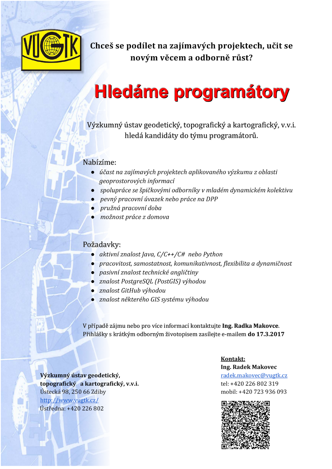
2016
7.2.2017 12:27 ČÚZK - předpisy a opatření Zeměměřický úřadvydává výroční zprávu úřadu za rok
2016
2016
7.2.2017 12:27 ČÚZK - předpisy a opatření Zeměměřický úřadvydává výroční zprávu úřadu za rok 2016
2016
2016
7.2.2017 12:27 ČÚZK - předpisy a opatření Zeměměřický úřadvydává výroční zprávu úřadu za rok 2016
2016
Aplikace pro poskytování ZPMZ v elektronické podobě
7.2.2017 12:02 Zeměměřič Nahlíení do KN bylo rozířeno o speciální aplikaci pro získání souborů ZPMZ v elektronické podobě. Aplikace je určena předevím pro získání potřebných podkladů pro vyhotovení geometrických plánů, nebo vytyčení hranice pozemků.V datech územně analytických p
7.2.2017 12:00 Plzeňský kraj V datech územně analytických podkladů Plzeňského kraje byla provedena kompletní aktualizace dat technické infrastruktury od poskytovatele GasNet, s.r.o. Data jsou s platností k 31. 1. 2017.V datech územně analytických p
7.2.2017 12:00 Plzeňský kraj V datech územně analytických podkladů Plzeňského kraje byla provedena kompletní aktualizace dat technické infrastruktury od poskytovatele GasNet, s.r.o. (http://geoportal.plzensky-kraj.cz/gs/rss?url=http%3A%2F%2Fgeoportal.plzensky-kraj.cz%2Ftw%2Fost%2Fgp%2Fuap%2Fposkytovatele%2Findex.php%3Fframe%26ID%3D540) Data jsou s platností k 31. 1. 2017.Změna sklonu dráhy pro vědu nad Marsem
7.2.2017 11:19 Český Kosmický PortálNejnovější průzkumná sonda ESA u Marsu se přemístila na novou oběžnou dráhu. Stalo se tak v rámci přípravy na přesun na finální dráhu pro průzkum Rudé planety.
Změna sklonu dráhy pro vědu nad Marsem
7.2.2017 11:19 Český Kosmický PortálNejnovější průzkumná sonda ESA u Marsu se přemístila na novou oběžnou dráhu. Stalo se tak v rámci přípravy na přesun na finální dráhu pro průzkum Rudé planety.
Škoda OCTAVIA Ambiente
7.2.2017 10:38 ČÚZK - předpisy a opatřeníČeský úřad zeměměřický a katastrální nabízí nepotřebný majetek k odkupu. Jedná se o
Škoda OCTAVIA Ambiente