


![]()

zprávy
zdroje zpráv:Prohlížecí služba WMS pro Katastrální mapu (KM)
21.12.2016 1:00 Cenia - Katalog metadat ČR - INSPIRE Prohlížecí služba WMS KN poskytuje možnost prohlížet obraz katastrální mapy složený z DKM, KMD, KM-D a OMP. Služba splňuje standard OGC WMS 1.1.1. a 1.3.0. Služba byla vytvořena za účelem zobrazování katastrální mapy nad rámec Směrnice INSPIRE. Služba umožňuje zobrazovat nejen digitální nebo digitalizovanou mapu, ale je doplněna analogovou mapou v místech, kde není digitální nebo digitalizovaná mapa k dipozici. Navíc obsahuje další náležitosti katastrální mapy, jako je vnitřní kresba atd.Děkujeme svým partnerům za spolupráci a přejeme vše nejlepší do nového roku 2017!
21.12.2016 1:00 VARS.czVážení obchodní partneři a milí přátelé, děkujeme Vám za projevenou důvěru a přízeň v uplynulém roce a do nového roku 2016 Vám přejeme hodně zdraví, štěstí a osobních i pracovních úspěchů.
Těšíme se na další setkání s Vámi a naši vzájemnou spolupráci.
WMS View Service for the Cadastral Index Map
21.12.2016 1:00 Cenia - Katalog metadat ČR - INSPIRE ELF Cadastre provides a simplified and harmonised view of information such as footprints of cadastral parcels geometry, addresses, buildings and the boundaries between neighbouring administrative units for pan-European use: in land administration domain such as agriculture, spatial planning, environmental, infrastructure and utilities management, public land management, risk and security services, socioeconomic data and cartography in general. ELF Cadastre aims to provide official cadastral reference data of the partner countries. ELF Cadastre will provide INSPIRE Cadastral Parcels features (core) from ELF data as a common minimum among all the existing cadastral systems, to be used only as locators of geo-information.INSPIRE téma Budovy (BU)
21.12.2016 1:00 Cenia - Katalog metadat ČR - INSPIRE Data odpovídají směrnici INSPIRE pro téma budovy (BU). Data pochází částečně z projektu RÚIAN (Registr územní identifikace, adres a nemovitostí), který je součástí základních registrů České Republiky a obsahuje informace o územní identifikaci, adresách a nemovitostech, a částečně z ISKN (Informační systém katastru nemovistostí). Zdrojem informací o budovách v ISKN je objekt Stavba, v RÚIAN je to Stavební objekt. Většina Staveb je zároveň Stavebními objekty, ale jsou případy, kdy tomu tak není. Kromě Budov datová sada obsahuje i části budov, které jsou pro potřeby INSPIRE vyjádřeny vchody z RÚIAN. Vchody obsahují informace o počtu podlaží, technickoekonomických atributech apod. Datová sada pokrývá celé území české republiky. V datové sadě není uvedeno ([BUDOV_CHYBI_PROCENT])%, t.j. 82793 budov (k 19. 12. 2016), protože neobsahují definiční bod ani polygon. Více v zákoně č. 111/2009 Sb., o základních registrech, ve vyhlášce č. 359/2011 Sb., o základním registru územní identifikace, adres a nemovitostí v platných zněních, v zákoně 256/2013 Sb., o katastru nemovitostí, v katastrální vyhlášce č. 357/2013 Sb. v platném znění a INSPIRE Data Specification on Buildings v 3.0 z 13.12.2013.INSPIRE téma Parcely (CP)
21.12.2016 1:00 Cenia - Katalog metadat ČR - INSPIRE Data odpovídají směrnici INSPIRE pro téma katastrální parcely (CP). Vychází z katastrální mapy, která je závazným státním mapovým dílem velkého měřítka, obsahuje body polohového bodového pole, polohopis a popis a může mít formu digitální mapy, analogové mapy nebo digitalizované mapy. Data publikovaná v rámci INSPIRE obsahují pouze katastrální území (pro celou Českou Republiku) a parcely a jejich hranice z území, kde je digitální mapa (k 19. 12. 2016 je to 88,44% území České republiky, t.j. 69 747,08km2). Více katastrální zákon 344/1992 SB., katastrální vyhláška č.26/2007 Sb. v platném znění a INSPIRE Data Specification on Cadastral Parcels v 3.0.1.Administrativní pracovník, Krajský pozemkový úřad pro Plzeňský kraj
21.12.2016 0:00 Státní pozemkový úřad Státní pozemkový úřad přijme zaměstnance na pozici administrativní pracovník, Krajský pozemkový úřad pro Plzeňský kraj.20161220odborný referent/vrchní referent oddělení aktualizace popisných informací-KP Praha-západ
20.12.2016 19:08 ČÚZK /Urady/Katastralni-urady/Katastralni-urady/Katastralni-urad-pro-Stredocesky-kraj/Katastralni-pracoviste/KP-Praha-zapad/O-uradu/Aktuality/20152509-Oznameni-na-reditele-PZ-(2)20161220odborný referent/vrchní referent oddělení aktualizace popisných informací-KP Praha-západ
20.12.2016 19:08 ČÚZK - předpisy a opatření Na úřední elektronické desce Katastrálního úřadu pro Středočeský kraj, v sekci "Oznámení a jiná úřední sdělení" bylo vystaveno "Oznámení o vyhlášení výběrového řízení na služební místo odborný referent/vrchní referent oddělení aktualizace popisných informací katastru nemovitostí II pro Katastrální pracoviště Praha-západ"20161220odborný referent/vrchní referent oddělení aktualizace popisných informací-KP Praha-západ
20.12.2016 19:05 ČÚZK /Urady/Katastralni-urady/Katastralni-urady/Katastralni-urad-pro-Stredocesky-kraj/O-uradu/Aktuality/20150901Oznameni-o-vyhlaseni-vyberoveho-rizen-(2)20161220odborný referent/vrchní referent oddělení aktualizace popisných informací-KP Praha-západ
20.12.2016 19:05 ČÚZK - předpisy a opatření V části "Úřední deska", v sekci "Oznámení a jiná úřední sdělení" bylo vystaveno "Oznámení o vyhlášení výběrového řízení služební místo odborný referent/vrchní referent oddělení aktualizace popisných informací katastru nemovitostí II pro Katastrální pracoviště Praha-západ"Odborný referent/vrchní referent oddělení aktualizace popisných informací katastru nemovitostí II
20.12.2016 18:57 ČÚZK - předpisy a opatření Katastrální úřad pro Středočeský kraj Katastrální pracoviště Praha-západvypisuje výběrové řízení na místo
Odborný referent/vrchní referent oddělení aktualizace popisných informací katastru nemovitostí II
Odborný referent/vrchní referent oddělení aktualizace popisných informací katastru nemovitostí II
20.12.2016 18:57 ČÚZK /Urady/Katastralni-urady/Katastralni-urady/Katastralni-urad-pro-Stredocesky-kraj/Uredni-deska/Oznameni-a-jina-uredni-sdeleni/Volna-mista/Odborny-referent-vrchni-referent-oddeleni-aktu-(7)Odborný referent/vrchní referent oddělení aktualizace popisných informací katastru nemovitostí II
20.12.2016 18:57 ČÚZK - volná místa Katastrální úřad pro Středočeský kraj, Katastrální pracoviště Praha-západ vypisuje výběrové řízení na místo Odborný referent/vrchní referent oddělení aktualizace popisných informací katastru nemovitostí II20161220_Odborný referent/vrchní referent oddělení aktualizace geodetických informací kat-KP Pra
20.12.2016 18:51 ČÚZK /Urady/Katastralni-urady/Katastralni-urady/Katastralni-urad-pro-Stredocesky-kraj/Katastralni-pracoviste/KP-Praha-vychod/O-uradu/Aktuality/20150901Oznameni-o-vyhlaseni-vyberoveho-rizeni-(5)20161220_Odborný referent/vrchní referent oddělení aktualizace geodetických informací kat-KP Pra
20.12.2016 18:51 ČÚZK - předpisy a opatření Na úřední elektronické desce Katastrálního úřadu pro Středočeský kraj, v sekci "Oznámení a jiná úřední sdělení" bylo vystaveno "Oznámení o vyhlášení výběrového řízení na služební místo Odborný referent/vrchní referent oddělení aktualizace geodetických informací katastru nemovitostí pro Katastrální pracoviště Praha-východ"20161220_Odborný referent/vrchní referent oddělení aktualizace geodetických informací kat-KP Pra
20.12.2016 18:49 ČÚZK - předpisy a opatření V části "Úřední deska", v sekci "Oznámení a jiná úřední sdělení" bylo vystaveno "Oznámení o vyhlášení výběrového řízení na služební místo odborný referent/vrchní referent oddělení aktualizace geodetických informací katastru nemovitostí pro Katastrální pracoviště Praha-východ"20161220_Odborný referent/vrchní referent oddělení aktualizace geodetických informací kat-KP Pra
20.12.2016 18:49 ČÚZK /Urady/Katastralni-urady/Katastralni-urady/Katastralni-urad-pro-Stredocesky-kraj/O-uradu/Aktuality/20150901Oznameni-o-vyhlaseni-vyberoveho-rizen-(1)Odborný referent/vrchní referent oddělení aktualizace geodetických informací katastru nemovitost
20.12.2016 18:45 ČÚZK /Urady/Katastralni-urady/Katastralni-urady/Katastralni-urad-pro-Stredocesky-kraj/Uredni-deska/Oznameni-a-jina-uredni-sdeleni/Volna-mista/Odborny-referent-vrchni-referent-oddeleni-aktu-(6)Odborný referent/vrchní referent oddělení aktualizace geodetických informací katastru nemovitost
20.12.2016 18:45 ČÚZK - volná místa Katastrální úřad pro Středočeský kraj, Katastrální pracoviště Praha-východ vypisuje výběrové řízení na místo Odborný referent/vrchní referent oddělení aktualizace geodetických informací katastru nemovitostOdborný referent/vrchní referent oddělení aktualizace geodetických informací katastru nemovitost
20.12.2016 18:45 ČÚZK - předpisy a opatření Katastrální úřad pro Středočeský kraj Katastrální pracoviště Praha-východvypisuje výběrové řízení na místo Odborný referent/vrchní referent oddělení aktualizace geodetických
Odborný referent/vrchní referent oddělení aktualizace geodetických informací katastru nemovitostí
vrchní referent / rada v oddělení obnovy katastrálního operátu Katastrálního úřadu pro Pardubický kr
20.12.2016 13:46 ČÚZK - volná místa Katastrální úřad pro Pardubický kraj, vypisuje výběrové řízení na místo vrchní referent / rada v oddělení obnovy katastrálního operátu Katastrálního úřadu pro Pardubický krvrchní referent / rada v oddělení obnovy katastrálního operátu Katastrálního úřadu pro Pardubický kr
20.12.2016 13:46 ČÚZK - předpisy a opatření Katastrální úřad pro Pardubický krajvypisuje výběrové řízení na místo
vrchní referent / rada v oddělení obnovy katastrálního operátu Katastrálního úřadu pro Pardubický kraj
vrchní referent / rada v oddělení obnovy katastrálního operátu Katastrálního úřadu pro Pardubický kr
20.12.2016 13:46 ČÚZK /Urady/Katastralni-urady/Katastralni-urady/Katastralni-urad-pro-Pardubicky-kraj/Uredni-deska/Oznameni-a-jina-uredni-sdeleni/Volna-mista/vrchni-referent-rada-v-oddeleni-obnovy-katastr-(1)vrchní referent / rada v oddělení obnovy katastrálního operátu Katastrálního úřadu pro Pardubick
20.12.2016 13:46 ČÚZK /Urady/Katastralni-urady/Katastralni-urady/Katastralni-urad-pro-Pardubicky-kraj/Uredni-deska/Oznameni-a-jina-uredni-sdeleni/Volna-mista/vrchni-referent-rada-v-oddeleni-obnovy-katastr-(1)Od 23. 12. 2016 do 1. 1. 2017
20.12.2016 12:00 Plzeňský kraj Od 23. 12. 2016 do 1. 1. 2017 dojde k omezení služeb vydávání, kontrol a akceptace Zakázek DTM. U žádostí o výdej a kontrolu dat doručených v této době může dojít k prodloužení lhůt při zpracování požadavků. Počítejte, prosím, s tímto omezením. V případě urgentních požadavků kontaktujte správce datového skladu viz kontakty (http://dtm.plzensky-kraj.cz/modul-zakazka/kontakty).Video-manuály z GIS „nejen“ pre študentov STU v Bratislave
20.12.2016 11:23 GISportal.cz Tieto video-manuály vznikli ako výukový materiál v rámci predmetu GIS vo vodnom hospodárstve. Na tvorbe ich obsahovej náplne sa podieľal kolektív autorov z Katedry vodného hospodárstva krajiny STU v Bratislave v zložení Michaela Danáčová, Roman Výleta, Peter Valent, ...Changing landscape
20.12.2016 10:20 ESA Observing the Earth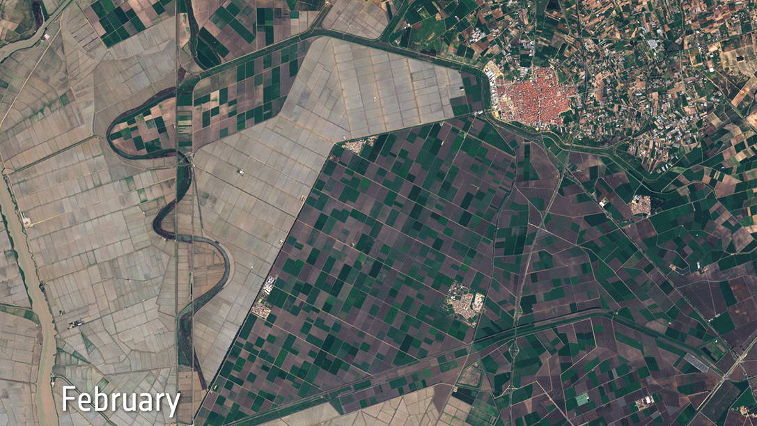
Sentinel-2 reveals changes over time in the fields of Spain’s Brazo de Este natural park and around the city of Los Palacios y Villafranca
Sledujte video jak na našem 3D modelu lomu vyrostly Alpy pro švýcarský film Gotthard
20.12.2016 10:02 UpVision Minulý týden měl premiéru ve Švýcarsku film Gotthard natáčený v Česku. Na tomto videu od trikařů z Mackevision můžete mimojiné vidět jak na námi vytvořeném 3D modelu lomu v Českém krasu vznikalo celé prostředí Alp a tunelu.https://vimeo.com/195946224
Odborný referent – Oddělení dokumentace katastru nemovitostí
20.12.2016 7:00 ČÚZK - volná místa Katastrální úřad pro Karlovarský kraj, Katastrální pracoviště Sokolov vypisuje výběrové řízení na místo Odborný referent – Oddělení dokumentace katastru nemovitostíOdborný referent – Oddělení dokumentace katastru nemovitostí
20.12.2016 7:00 ČÚZK /Urady/Katastralni-urady/Katastralni-urady/Katastralni-urad-pro-Karlovarsky-kraj/Uredni-deska/Oznameni-a-jina-uredni-sdeleni/Volna-mista/Odborny-referent-–-Oddeleni-dokumentace-katastru-nOdborný referent – Oddělení dokumentace katastru nemovitostí
20.12.2016 7:00 ČÚZK - předpisy a opatření Katastrální úřad pro Karlovarský kraj Katastrální pracoviště Sokolovvypisuje výběrové řízení na místo
Odborný referent – Oddělení dokumentace katastru nemovitostí
Intel získal firmu z inkubátoru ESA
20.12.2016 7:00 Český Kosmický PortálNa světě jsou tisíce firem, které se věnují dronům, ale Intel se rozhodl získat do svého portfolia společnost Mavinci: jde o start-up z podnikatelského inkubátoru ESA v Německu, který vyvíjí snadno ovladatelný systém pro dálkové pozorování země.
INSPIRE téma Adresy (AD)
20.12.2016 1:00 Cenia - Katalog metadat ČR - INSPIRE Data odpovídají směrnici INSPIRE pro téma adresy (AD). Vychází především z projektu RÚIAN (Registr územní identifikace, adres a nemovitostí), který je součástí základních registrů České Republiky a obsahuje informace o územní identifikaci, adresách a nemovitostech. Data publikovaná v rámci INSPIRE obsahují pouze adresní místa a jejich komponenty, kterými jsou stát, obec, část obce, městský obvod v Praze (MOP), městký obvod/městská část (MO/MČ), ulice a pošta a to na území celé České Republiky. Obsahují rozvněž geometrii, která určuje definiční bod adresního místa. V datové sadě nění uvedeno 2,44%, t.j. 70870 adresních míst (k 19. 12. 2016), protože neobsahují definiční bod, podle kterého by je bylo možné prostorově určit. Více v zákoně č. 111/2009 Sb., o základních registrech a ve vyhlášce č. 359/2011 Sb., o základním registru územní identifikace, adres a nemovitostí v platných zněních a INSPIRE Data Specification on Addresses v 3.0.1 z 26.4.2010.E-shop ČGS
20.12.2016 1:00 Cenia - Katalog metadat ČR - INSPIRE Aplikace pro online obchod České geologické služby, největšího vydavatele geologické literatury v ČR. Tento e-shop nabízí kolem 2600 položek, a to jak z vlastní produkce, tak od jiných nakladatelství. Prodává hlavně mapy, knihy, časopisy, ale také DVD, CD nebo pracovní nářadí a pomůcky. Nezaměřuje se pouze na odborníky, ale zajišťuje knihy pro děti, nebo pro širokou veřejnost.INSPIRE téma Parcely (CP)
20.12.2016 1:00 Cenia - Katalog metadat ČR - INSPIRE Data odpovídají směrnici INSPIRE pro téma katastrální parcely (CP). Vychází z katastrální mapy, která je závazným státním mapovým dílem velkého měřítka, obsahuje body polohového bodového pole, polohopis a popis a může mít formu digitální mapy, analogové mapy nebo digitalizované mapy. Data publikovaná v rámci INSPIRE obsahují pouze katastrální území (pro celou Českou Republiku) a parcely a jejich hranice z území, kde je digitální mapa (k 19. 12. 2016 je to 88,44% území České republiky, t.j. 69 747,08km2). Více katastrální zákon 256/2013 Sb., katastrální vyhláška č.357/2013 Sb. v platném znění a INSPIRE Data Specification on Cadastral Parcels v 3.0.1.INSPIRE téma Budovy (BU)
20.12.2016 1:00 Cenia - Katalog metadat ČR - INSPIRE Data odpovídají směrnici INSPIRE pro téma budovy (BU). Data pochází částečně z projektu RÚIAN (Registr územní identifikace, adres a nemovitostí), který je součástí základních registrů České Republiky a obsahuje informace o územní identifikaci, adresách a nemovitostech, a částečně z ISKN (Informační systém katastru nemovistostí). Zdrojem informací o budovách v ISKN je objekt Stavba, v RÚIAN je to Stavební objekt. Většina Staveb je zároveň Stavebními objekty, ale jsou případy, kdy tomu tak není. Kromě Budov datová sada obsahuje i části budov, které jsou pro potřeby INSPIRE vyjádřeny vchody z RÚIAN. Vchody obsahují informace o počtu podlaží, technickoekonomických atributech apod. Datová sada pokrývá celé území české republiky. V datové sadě není uvedeno 1,97%, t.j. 82793 budov (k 19. 12. 2016), protože neobsahují definiční bod ani polygon. Více v zákoně č. 111/2009 Sb., o základních registrech, ve vyhlášce č. 359/2011 Sb., o základním registru územní identifikace, adres a nemovitostí v platných zněních, v zákoně 256/2013 Sb., o katastru nemovitostí, v katastrální vyhlášce č. 357/2013 Sb. v platném znění a INSPIRE Data Specification on Buildings v 3.0 z 13.12.2013.Oznámení o vyhlášení výběrového řízení na služební místo odborný rada oddělení převodu majetku státu, Krajský pozemkový úřad pro Moravskoslezský kraj
20.12.2016 0:00 Státní pozemkový úřad Ústřední ředitelka Státního pozemkového úřadu, jako služební orgán příslušný podle § 10 odst. 1 písm. f) zákona č. 234/2014 Sb., o státní službě (dále jen „zákon“), vyhlašuje výběrové řízení.Oznámení o vyhlášení výběrového řízení na služební místo ředitel sekce ICT a správy dat
20.12.2016 0:00 Státní pozemkový úřad Ústřední ředitelka Státního pozemkového úřadu, jako služební orgán příslušný podle § 10 odst. 1 písm. f) zákona č. 234/2014 Sb., o státní službě (dále jen „zákon“), vyhlašuje výběrové řízení.Oznámení o vyhlášení výběrového řízení na služební místo ředitel odboru právního
20.12.2016 0:00 Státní pozemkový úřad Ústřední ředitelka Státního pozemkového úřadu, jako služební orgán příslušný podle § 10 odst. 1 písm. f) zákona č. 234/2014 Sb., o státní službě (dále jen „zákon“), vyhlašuje výběrové řízení.There’s a jet stream in our core
19.12.2016 20:50 ESA Observing the Earth
We would normally associate jet streams with the weather but, thanks to ESA’s magnetic field mission, scientists have discovered a jet stream deep below Earth’s surface – and it’s speeding up.
Uzavření přepážky výdeje dat
19.12.2016 16:45 Geoportál PrahaOd 23.12.2016 do 30.12.2016 bude přepážka pro osobní odběr dat z provozních důvodů uzavřena.
Building the E-GNSS engine for self-driving car
19.12.2016 15:58 European GNSS Agency
In 2015, the European GNSS Agency (GSA) launched Fundamental Elements, an R&D funding mechanism supporting the development of global navigation satellite system-(GNSS) enabled chipsets, receivers and antennas. The mechanism aims to support the development of innovative chipset and receiver technology that industry would not invest in on its own initiative, thus accelerating their integration of Galileo and EGNOS into market-ready devices. The end goal is to develop close-to-market chipsets, receivers and antennas in targeted markets. The first project to come out Fundamental Elements is dedicated to the automotive segment.
With connected vehicles and autonomous driving vehicles being the most relevant trend in the automotive sector – both now and for the foreseeable future – there is a clear need to provide accurate and reliable positioning information for safety-critical applications. Within the context of road transportation, safety-critical applications are defined as those that possess the potential to, directly or indirectly, avoid causing harm to humans, destroying the vehicle or damaging external property or the environment. Autonomous driving, advanced driver-assistance systems (ADAS) and dangerous goods transportation are all included in this group.
Also read: Driving towards the autonomous vehicle
The traditional way of providing the required accurate and reliable positioning information is to make use of multiple sources of sensor data. The problem with this approach is that it requires the use of such sophisticated equipment as radar/lidar-based sensor and cameras, which tend to be expensive. Furthermore, as this equipment is not specifically designed for use with automotive consumer applications, it is not fully suitable to provide reliable positioning information.
A dedicated solution
The European Safety Critical Applications Positioning Engine (ESCAPE) project aims to overcome these multiple challenges by developing a dedicated, reliable and accurate engine, specifically designed for automotive safety-critical applications. The ESCAPE project is funded under the Fundamental Elements Development of E-GNSS engine for safety-critical multi-applications in road transport call.
Read this: Satellite navigation at core of future connected car systems
The project consortium includes stakeholders from across the automotive value chain, including Renault, FICOSA, GMV and ST. Under the ESCAPE umbrella, these companies are pooling their complementary competences and pre-existing knowledge to develop an innovative positioning engine that exploits European GNSS (E-GNSS) differentiators and will be available for future commercialisation. Ultimately, the project will develop the first multi-constellation Galileo chipset receiver with multi-frequency capability specifically adapted to road applications – and in particular autonomous vehicles.
Re-defining the state of the art
According to project researchers, the ESCAPE engine will surpass current definitions of ‘state of the art’. “For the first time, an E-GNSS engine will provide an integrity-focused, safety-critical positioning system that fully integrates GNSS, on-board sensors, cameras and maps,” says GSA Head of Market Development Gian Gherardo Calini. The engine’s core features include:
- a GNSS/Galileo multi-constellation, multi-frequency chipset for road applications
- use of the precise point positioning (PPP) service
- hybridisation of cameras, maps, vehicle sensors and GNSS integrated into a tight coupling filter
- provision of an integrity layer to the exploited technologies
- optional capability to implement navigation message authentication
Over the course of three years, these technologies will be integrated into the resulting ESCAPE engine. At that point, the engine will be close to commercialisation, with rapid market uptake expected.
Media note: This feature can be republished without charge provided the European GNSS Agency (GSA) is acknowledged as the source at the top or the bottom of the story. You must request permission before you use any of the photographs on the site. If you republish, we would be grateful if you could link back to the GSA website (http://www.gsa.europa.eu).
Building a E-GNSS engine the self-driving car
19.12.2016 15:58 European GNSS AgencyIn 2015, the European GNSS Agency (GSA) launched Fundamental Elements, an R&D funding mechanism supporting the development of global navigation satellite system-(GNSS) enabled chipsets, receivers and antennas. The mechanism aims to support the development of innovative chipset and receiver technology that industry would not invest in on its own initiative, thus accelerating their integration of Galileo and EGNOS into market-ready devices. The end goal is to develop close-to-market chipsets, receivers and antennas in targeted markets. The first project to come out Fundamental Elements is dedicated to the automotive segment.
With connected vehicles and autonomous driving vehicles being the most relevant trend in the automotive sector – both now and for the foreseeable future – there is a clear need to provide accurate and reliable positioning information for safety-critical applications. Within the context of road transportation, safety-critical applications are defined as those that possess the potential to, directly or indirectly, avoid causing harm to humans, destroying the vehicle or damaging external property or the environment. Autonomous driving, advanced driver-assistance systems (ADAS) and dangerous goods transportation are all included in this group.
Also read: Driving towards the autonomous vehicle
The traditional way of providing the required accurate and reliable positioning information is to make use of multiple sources of sensor data. The problem with this approach is that it requires the use of such sophisticated equipment as radar/lidar-based sensor and cameras, which tend to be expensive. Furthermore, as this equipment is not specifically designed for use with automotive consumer applications, it is not fully suitable to provide reliable positioning information.
A dedicated solution
The European Safety Critical Applications Positioning Engine (ESCAPE) project aims to overcome these multiple challenges by developing a dedicated, reliable and accurate engine, specifically designed for automotive safety-critical applications. The ESCAPE project is funded under the Fundamental Elements Development of E-GNSS engine for safety-critical multi-applications in road transport call.
Read this: Satellite navigation at core of future connected car systems
The project consortium includes stakeholders from across the automotive value chain, including Renault, FICOSA, GMV and ST. Under the ESCAPE umbrella, these companies are pooling their complementary competences and pre-existing knowledge to develop an innovative positioning engine that exploits European GNSS (E-GNSS) differentiators and will be available for future commercialisation. Ultimately, the project will develop the first multi-constellation Galileo chipset receiver with multi-frequency capability specifically adapted to road applications – and in particular autonomous vehicles.
Re-defining the state of the art
According to project researchers, the ESCAPE engine will surpass current definitions of ‘state of the art’. “For the first time, an E-GNSS engine will provide an integrity-focused, safety-critical positioning system that fully integrates GNSS, on-board sensors, cameras and maps,” says GSA Head of Market Development Gian Gherardo Calini. The engine’s core features include:
- a GNSS/Galileo multi-constellation, multi-frequency chipset for road applications
- use of the precise point positioning (PPP) service
- hybridisation of cameras, maps, vehicle sensors and GNSS integrated into a tight coupling filter
- provision of an integrity layer to the exploited technologies
- optional capability to implement navigation message authentication
Over the course of three years, these technologies will be integrated into the resulting ESCAPE engine. At that point, the engine will be close to commercialisation, with rapid market uptake expected.
Media note: This feature can be republished without charge provided the European GNSS Agency (GSA) is acknowledged as the source at the top or the bottom of the story. You must request permission before you use any of the photographs on the site. If you republish, we would be grateful if you could link back to the GSA website (http://www.gsa.europa.eu).
Seriál ozvěny technické podpory 2016 – díl čtvrtý
19.12.2016 12:47 ARCDATAV posledním díle seriálu, který připravili kolegové z technické podpory, je věnována pozornost třem tématům:
- Jak vložit Story Map na webovou stránku nebo ji použít v další mapě
- Alokace licence ArcGIS Pro
- K převodu sloupců typu float mezi souborovou a SDE geodatabází
Tímto došel letošní seriál Ozvěny technické podpory do svého závěru. Novinky, tipy a triky můžete i nadále sledovat na stránkách technické podpory a na seriál ozvěn se můžete těšit opět za rok.

Nová verze MapBasic 16
19.12.2016 12:45 CSmap Koncem října 2016 vyšla nová verze programu MapBasic 16.0. Stejně jako MapInfo Pro 16.0 je také MapBasic 16.0 pouze pro 64-bitové systémy.Programy kompilované 64-bitovou verzí MapBasic Editor/Compiler jsou určené pro 64-bitové systémy, tudíž nebudou fungovat v rámci 32-bitové verze MapInfo Pro. Funkcionalita nové verze kopíruje funkce dostupné v programu MapInfo Pro 16.0
rada/odborný rada – právník
19.12.2016 12:20 ČÚZK - předpisy a opatření
Oznámení o vyhlášení výběrového řízení na služební místo rada/odborný rada – právník v personálním oddělení na Katastrálním úřadu pro Vysočinu, místo výkonu služby Jihlava zde.
rada/odborný rada – právník
19.12.2016 12:20 ČÚZK /Urady/Katastralni-urady/Katastralni-urady/Katastralni-urad-pro-Vysocinu/O-uradu/Aktuality/rada-odborny-rada-–-pravnikRada/odborný rada – právník v personálním oddělení.
19.12.2016 12:17 ČÚZK - předpisy a opatření Katastrální úřad pro Vysočinuvypisuje výběrové řízení na místo
Rada/odborný rada – právník v personálním oddělení.
Rada/odborný rada – právník v personálním oddělení.
19.12.2016 12:17 ČÚZK /Urady/Katastralni-urady/Katastralni-urady/Katastralni-urad-pro-Vysocinu/Uredni-deska/Oznameni-a-jina-uredni-sdeleni/Volna-mista/Rada-odborny-rada-–-pravnik-v-personalnim-oddeleniRada/odborný rada – právník v personálním oddělení.
19.12.2016 12:17 ČÚZK - volná místa Katastrální úřad pro Vysočinu, vypisuje výběrové řízení na místo Rada/odborný rada – právník v personálním oddělení.Upozornění
19.12.2016 10:41 ČÚZK - předpisy a opatření Dne 28. 12. 2016 bude Kontaktní místo Katastrálního pracoviště Jihlava v Telči z technických důvodů zavřeno.Provoz od 2. 1. 2017 bude beze změn.
zde
Upozornění
19.12.2016 10:41 ČÚZK /Urady/Katastralni-urady/Katastralni-urady/Katastralni-urad-pro-Vysocinu/Katastralni-pracoviste/KP-Jihlava/O-uradu/Aktuality/UpozorneniDěkujeme za spolupráci a těšíme se na setkání v příštím roce
19.12.2016 9:30 HrdličkaThe post Děkujeme za spolupráci a těšíme se na setkání v příštím roce appeared first on HRDLIČKA spol. s r.o. - komplexní služby v oblasti geodézie.
Děkujeme za spolupráci a těšíme se na setkání v příštím roce
19.12.2016 9:30 HrdličkaThe post Děkujeme za spolupráci a těšíme se na setkání v příštím roce appeared first on HRDLIČKA spol. s r.o. - komplexní služby v oblasti geodézie.
Mapa kultur stabilního katastru
19.12.2016 8:12 Zeměměřič Mapa kultur stabilního katastru z fondů ÚAZK byla doplněna do aplikace Archivní mapy. Tato součást vceňovacího operátu stabilního katastru zachycuje v přibliném měřítku 1:36 000 ploný rozsah jednotlivých existujících kultur v Čechách v rozpětí let 1837-1844.Nástěnné kalendáře Zeměměřiče a GEOinformace 2017
19.12.2016 7:06 Zeměměřič si můete také zdarma vytisknout ve formátu, který potřebujete.Výstup z ISS pro kosmonauta Thomase Pesqueta
19.12.2016 6:58 Český Kosmický PortálKosmonaut ESA Thomas Pesquet se již brzy stane jedenáctým Evropanem, který uskuteční výstup do otevřeného prostoru. Stane se tak příští měsíc, kdy ve skafandru vystoupí z Mezinárodní kosmické stanice.
Výstup z ISS pro kosmonauta Thomase Pesqueta
19.12.2016 6:58 Český Kosmický PortálKosmonaut ESA Thomas Pesquet se již brzy stane jedenáctým Evropanem, který uskuteční výstup do otevřeného prostoru. Stane se tak příští měsíc, kdy ve skafandru vystoupí z Mezinárodní kosmické stanice.
INSPIRE téma Budovy (BU)
18.12.2016 1:00 Cenia - Katalog metadat ČR - INSPIRE Data odpovídají směrnici INSPIRE pro téma budovy (BU). Data pochází částečně z projektu RÚIAN (Registr územní identifikace, adres a nemovitostí), který je součástí základních registrů České Republiky a obsahuje informace o územní identifikaci, adresách a nemovitostech, a částečně z ISKN (Informační systém katastru nemovistostí). Zdrojem informací o budovách v ISKN je objekt Stavba, v RÚIAN je to Stavební objekt. Většina Staveb je zároveň Stavebními objekty, ale jsou případy, kdy tomu tak není. Kromě Budov datová sada obsahuje i části budov, které jsou pro potřeby INSPIRE vyjádřeny vchody z RÚIAN. Vchody obsahují informace o počtu podlaží, technickoekonomických atributech apod. Datová sada pokrývá celé území české republiky. V datové sadě není uvedeno ([BUDOV_CHYBI_PROCENT])%, t.j. 83341 budov (k 12. 12. 2016), protože neobsahují definiční bod ani polygon. Více v zákoně č. 111/2009 Sb., o základních registrech, ve vyhlášce č. 359/2011 Sb., o základním registru územní identifikace, adres a nemovitostí v platných zněních, v zákoně 256/2013 Sb., o katastru nemovitostí, v katastrální vyhlášce č. 357/2013 Sb. v platném znění a INSPIRE Data Specification on Buildings v 3.0 z 13.12.2013.INSPIRE téma Parcely (CP)
18.12.2016 1:00 Cenia - Katalog metadat ČR - INSPIRE Data odpovídají směrnici INSPIRE pro téma katastrální parcely (CP). Vychází z katastrální mapy, která je závazným státním mapovým dílem velkého měřítka, obsahuje body polohového bodového pole, polohopis a popis a může mít formu digitální mapy, analogové mapy nebo digitalizované mapy. Data publikovaná v rámci INSPIRE obsahují pouze katastrální území (pro celou Českou Republiku) a parcely a jejich hranice z území, kde je digitální mapa (k 12. 12. 2016 je to 87,96% území České republiky, t.j. 69 369,15km2). Více katastrální zákon 344/1992 SB., katastrální vyhláška č.26/2007 Sb. v platném znění a INSPIRE Data Specification on Cadastral Parcels v 3.0.1.Satellite cousins have ice covered
16.12.2016 15:50 ESA Observing the Earth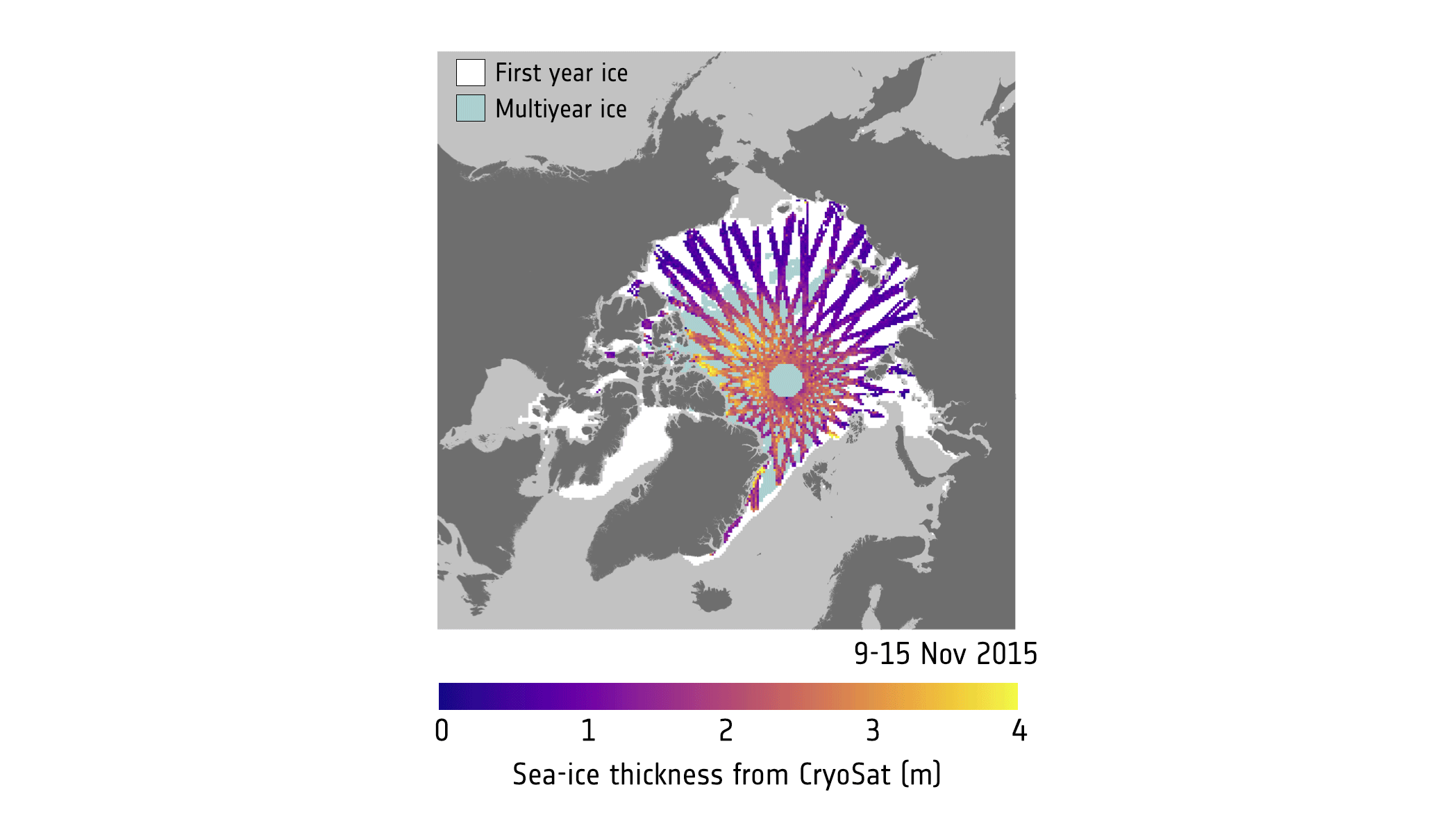
Although not designed to deliver information on ice, ESA’s Earth Explorer SMOS satellite can detect thin sea-ice. Since its cousin, CryoSat, is better at measuring thicker ice scientists have found a way of using these missions together to yield an even clearer picture of the changing Arctic.
INFORMACE PRO KLIENTY
16.12.2016 15:46 ČÚZK /Urady/Katastralni-urady/Katastralni-urady/Katastralni-urad-pro-hlavni-mesto-Prahu/O-uradu/Aktuality/INFORMACE-PRO-KLIENTYINFORMACE PRO KLIENTY
16.12.2016 15:46 ČÚZK - předpisy a opatřeníV souvislosti se šířením informací na internetu ohledně správnosti orientace úředních
razítek se státním znakem na výpisech z katastru nemovitostí a prokazování
vlastnictví pro registraci majetku u tzv. „Říšského katastrálního úřadu v Krakově“ do
1. 1. 2017 sdělujeme, že jedná o dezinformaci, tzv. HOAX. Nedoporučujeme Vám
zasílat listy vlastnictví neznámým osobám pro tzv. registraci. Může se jednat o pokus
podvodně získat osobní údaje vlastníků nemovitostí.
INFORMACE PRO KLIENTY
16.12.2016 15:46 ČÚZK - předpisy a opatřeníV souvislosti se šířením informací na internetu ohledně správnosti orientace úředních razítek se státním znakem na výpisech z katastru nemovitostí a prokazování vlastnictví pro registraci majetku u tzv. „Říšského katastrálního úřadu v Krakově“ do 1. 1. 2017 sdělujeme, že se jedná o dezinformaci, tzv. HOAX. Nedoporučujeme Vám zasílat listy vlastnictví neznámým osobám pro tzv. registraci. Může se jednat o pokus podvodně získat osobní údaje vlastníků nemovitostí.
ArcGIS 10.5
16.12.2016 15:30 ARCDATASpolečnost Esri vydala nejnovější verzi systému ArcGIS, jejíž instalační soubory můžete získat na stránkách My Esri. Přečtěte si, co ArcGIS 10.5 přináší.
ArcMap
V aplikaci ArcMap přibyla řada nových geoprocessingových nástrojů. Split By Attributes rozdělí datovou sadu na několik nových datových sad, ve kterých budou mít prvky stejnou hodnotu určeného atributu (nebo kombinací atributů). Graphic Buffer vytvoří obalové zóny vhodné pro kartografické maskování, jejichž rohy mohou být kulaté, ostré či seříznuté podobně, jako je tomu při nastavení typu linie v grafických programech.
V sadě nástrojů Správa dat jsou to například nástroje Build Stereo Model, Compute Camera Model, Compute Mosaic Candidates a Generate Point Cloud; při editaci nově pomohou nástroje Align Features a Calculate Transformation Errors.
U mnohých ze stávajících nástrojů přibyly nové parametry nebo byly vylepšeny jejich algoritmy: kartografické nástroje Simplify Line a Simplify Polygon používají nový způsob generalizace prvků a dokážou uvažovat i prvky v jiných datových sadách jako „bariéry“, například aby se po generalizaci pobřeží nenacházela pobřežní cesta v moři.
Podrobné informace o novinkách naleznete na stránce What's new in ArcMap.
Geodatabáze
V ArcGIS 10.5 rovněž došlo k optimalizaci několika nástrojů pro práci s geodatabází. Rozšířen byl nástroj Register with Geodatabase, který umožňuje registrovat pohledy v enterprise geodatabázi. Log file tabulky v PostgreSQL a SQL Server jsou vytvářeny jako dočasné a vždy je vytvářena pouze jedna pro každého z uživatelů, což zvyšuje rychlost komunikace s databází.
Přibyl rovněž nový datový typ pro ukládání mozaikové datové sady v databázích Oracle, PostgreSQL a SQL Server – rasterblob.
Změny názvů
Jméno produktu ArcGIS for Server se poslední dobou stalo mírně zavádějící, protože vedle samotného serveru byly jeho součástí také Portal for ArcGIS, úložiště ArcGIS Data Store a komunikační rozhraní ArcGIS Web Adaptor. Celé toto řešení se proto od verze 10.5 jmenuje ArcGIS Enterprise.
Názvem ArcGIS Server se tedy nyní označuje pouze vlastní serverová část, která existuje v některé z následujících rolí:
- ArcGIS GIS Server
- ArcGIS Image Server
- ArcGIS GeoAnalytics Server
- ArcGIS GeoEvent Server
- Esri Business Analyst Server
Více podrobností o změnách v serverové části platformy ArcGIS naleznete na stránce What’s new in ArcGIS Server 10.5.
Portal for ArcGIS
Také Portal for ArcGIS doznal významných vylepšení. Mezi mnoha novými funkcemi jmenujme například možnost propojení několika portálů, možnost ovládat některé funkce pomocí ArcGIS Python API, podporu aplikace Insights for ArcGIS, úpravy stránek s údaji o položce, vylepšenou bezpečnost, nové funkce v mapovém prohlížeči a mnoho dalších úprav.
What's new in Portal for ArcGIS 10.5.
Instalace ArcGIS 10.5
Instalační soubory naleznete na portálu My Esri v sekci Moje organizace – Stahování.
Prezentace závěrečných prací v poločase 2017
16.12.2016 14:21 Blogující geomatici - FAV ZČU 9. 2. 2017 od 9:30 v UN 656 proběhnou prezentace závěrečných prací studentů geomatiky v poločase. Primárním cílem je obhájit záměr a dosavadní směřování práce před pedagogy oddělení geomatiky, nicméně prezentace a následná diskuse je otevřena a doporučena i studentům ostatních ročníků. Studenti, přihlašujte se prosím do sdílené tabulky.V seznamu mapových služeb obla
16.12.2016 12:00 Plzeňský kraj V seznamu mapových služeb oblasti Doprava a silniční hospodářství byla rozšířena mapová služba Dopravní nehodovost na silnicích v Plzeňském kraji. Nově jsou doplněna data z let 2013, 2014 a 2015. Po kliknutí na patřičný silniční úsek se vypíší podrobné údaje o nehodovosti. Mapa byla vytvořena ve spolupráci s Policií ČR.V seznamu mapových služeb obla
16.12.2016 12:00 Plzeňský kraj V seznamu mapových služeb oblasti Doprava a silniční hospodářství (http://geoportal.plzensky-kraj.cz/gs/doprava-a-silnicni-hospodastvi) byla rozšířena mapová služba Dopravní nehodovost na silnicích v Plzeňském kraji (http://mapy.kr-plzensky.cz/gis/dopravni_nehody). Nově jsou doplněna data z let 2013, 2014 a 2015. Po kliknutí na patřičný silniční úsek se vypíší podrobné údaje o nehodovosti. Mapa byla vytvořena ve spolupráci s Policií ČR.Galileo goes live
16.12.2016 11:38 European GNSS Agency
With the Declaration of Galileo Initial Services, Galileo officially moves from a testing phase to the provision of live services. For the first time ever, users around the world can be guided using the positioning, navigation and timing information provided by Galileo’s global satellite constellation. Starting now, any mass-market device containing a Galileo-enabled chipset, such as smartphones and vehicle navigation devices, can use Galileo.
“Today we are really making history,” says European Commission Vice President responsible for the Energy Union Maroš Šefčovič. “With Galileo, Europe gains its own satellite navigation system that will improve a range of everyday services for our citizens and strengthens Europe’s strategic autonomy.”
“Galileo is now alive and kicking,” says Elzbieta Bienkowska European Commissioner for Internal Market, Industry, Entrepreneurship and SMEs. “Galileo Initial Services is the result of a concerted effort to design and build the most accurate navigation system in the world. It demonstrates the technological excellence of Europe and its commitment to delivering space-based services and applications and, as such, represents a special achievement of a united Europe.”
GSA in the driver’s seat
With the launch of Initial Services, Galileo officially transitions from a system in testing to a system in service. As Europe’s link between space technology and user needs, the GSA has been delegated the responsibility for the Galileo service provision by the European Commission. As of 1 January 2017, the GSA will have the core task of ensuring a return on investment from Galileo in the form of clear, across-the-board services and applications for end users.

“The GSA is now putting into practice all that it has been preparing for,” adds GSA Executive Director Carlo des Dorides. “The centre of gravity for the Galileo programme is now the user and, meaning European citizens, businesses and entrepreneurs can benefit from the many innovative opportunities created by European GNSS.”
In overseeing the Galileo service provision, the GSA will:
- oversee the operation of such key service facilities as the Galileo Security Monitoring Centre (GSMC) in France and the United Kingdom, the GSC in Spain and the Galileo Reference Centre (GRC) in the Netherlands;
- maximise adoption across user market segments and fostering EU economic and industrial benefits;
- make the Public Regulated Service (PRS) the service of choice for all authorised users, providing the same high level of availability and robustness that is otherwise only available from military-based GNSS systems (GPS, GLONASS, Beidou);
- position Galileo as the first constellation of choice in search and rescue beacons.
What Galileo Initial Services means for you
With Galileo Initial Services, users benefit from a more accurate navigation and positioning that saves time and allows one to travel safer. For example, thanks to Galileo’s Search and Rescue service, locating distress beacons is substantially improved. As a result, after someone activates a distress beacon, the time to find them, whether they are lost at sea or in the mountains, is reduced from up to three hours to just ten minutes. Additionally, the distress beacon’s location can be more accurately determined, to within 5km – a substantial improvement on the current 10km.
Europe will also enjoy substantial economic growth. This is because the use of satellite navigation has helped drive world economic growth, particularly in high-tech industries. Experts predict that the global satellite navigation market will itself grow by more than 18% up until 2019. The additional resiliency provided by Galileo is expected to enable a range of new applications and services that will benefit from increased positioning reliability, thus further driving economic growth in Europe and beyond.
Galileo compatible products available today
The Declaration of Galileo Initial Services is also excellent news for chipset and receiver manufacturers and application developers, whose Galileo-enabled products can now start using Galileo signals.
Today, 17 companies, representing more than 95% of the global satellite navigation supply market, produce Galileo-ready chips. These include such key chipset manufacturers as u-blox, Broadcom, Mediatek, Intel and Qualcomm. There are also a number of Galileo-ready devices on the market, including smartphones and in-vehicle navigation systems.
You can find up-to-date information on all available Galileo compatible products at www.useGalileo.eu
Understanding Initial Services
Galileo is Europe’s Global Satellite Navigation System (GNSS). The Declaration of Initial Services – a combined effort of the European Commission, European GNSS Agency (GSA), and European Space Agency (ESA) – is the first step towards reaching full operational capability.
The first services offered by Galileo include the Open Service, Public Regulated Service (PRS) and Search and Rescue Service (SaR). All of these services are available free of charge.
Galileo Initial Services are fully interoperable with GPS – a combination that provides users with considerable improvements, with stronger performance and service levels. With Galileo satellites working in conjunction with GPS, there are more satellites available, meaning more accurate and reliable positioning for end users. In particular, navigation in cities, where satellite signals can often be blocked by tall buildings, benefit from the increased positioning accuracy this provides.
History in the making
Galileo is unique in that it is the only civil-based GNSS initiative. Whereas the United States’ GPS, Russia’s GLONASS, and China’s Beidou systems – among others – are all operated by their respective militaries, Europe’s Galileo programme stands alone as the world’s only option for GNSS under civil control. This is an important distinction, especially as the world’s dependence on GNSS continues to increase. From individuals to private businesses, the public sector and academia, as more and more services become dependent on the availability of an accurate GNSS signal, the implications of a possible signal failure becomes increasingly dangerous.
With some foresight, 20 years ago the EU recognised the need for a European-controlled satellite navigation system. In the years since, the EU has successfully launched and implemented EGNOS and, today, Galileo Initial Services.
Initial Services is the first step toward full operational capability, which will occur when the Galileo constellation is complete by 2020. Between the declaration of Initial Services and full operational capability, additional satellites will be added to the constellation, allowing new services to become available.
Learn more
The GSA’s Galileo Initial Services page
The European GNSS Service Centre is the place to go for all things related to developing Galileo-capable products and services.

Media note: This feature can be republished without charge provided the European GNSS Agency (GSA) is acknowledged as the source at the top or the bottom of the story. You must request permission before you use any of the photographs on the site. If you republish, we would be grateful if you could link the article back to the GSA website (http://www.gsa.europa.eu).
Galileo goes live
16.12.2016 11:38 European GNSS Agency

With the Declaration of Galileo Initial Services, Galileo officially moves from a testing phase to the provision of live services. For the first time ever, users around the world can be guided using the positioning, navigation and timing information provided by Galileo’s global satellite constellation. Starting now, any mass-market device containing a Galileo-enabled chipset, such as smartphones and vehicle navigation devices, can use Galileo.
“Today we are really making history,” says European Commission Vice President responsible for the Energy Union Maroš Šefčovič. “With Galileo, Europe gains its own satellite navigation system that will improve a range of everyday services for our citizens and strengthens Europe’s strategic autonomy.”
“Galileo is now alive and kicking,” says Elzbieta Bienkowska European Commissioner for Internal Market, Industry, Entrepreneurship and SMEs. “Galileo Initial Services is the result of a concerted effort to design and build the most accurate navigation system in the world. It demonstrates the technological excellence of Europe and its commitment to delivering space-based services and applications and, as such, represents a special achievement of a united Europe.”
GSA in the driver’s seat
With the launch of Initial Services, Galileo officially transitions from a system in testing to a system in service. As Europe’s link between space technology and user needs, the GSA has been delegated the responsibility for the Galileo service provision by the European Commission. As of 1 January 2017, the GSA will have the core task of ensuring a return on investment from Galileo in the form of clear, across-the-board services and applications for end users.
Watch this: Galileo goes live, Initial Services declaration
“The GSA is now putting into practice all that it has been preparing for,” adds GSA Executive Director Carlo des Dorides. “The centre of gravity for the Galileo programme is now the user and, meaning European citizens, businesses and entrepreneurs can benefit from the many innovative opportunities created by European GNSS.”
In overseeing the Galileo service provision, the GSA will:
- oversee the operation of such key service facilities as the Galileo Security Monitoring Centre (GSMC) in France and the United Kingdom, the GSC in Spain and the Galileo Reference Centre (GRC) in the Netherlands;
- maximise adoption across user market segments and fostering EU economic and industrial benefits;
- make the Public Regulated Service (PRS) the service of choice for all authorised users, providing the same high level of availability and robustness that is otherwise only available from military-based GNSS systems (GPS, GLONASS, Beidou);
- position Galileo as the first constellation of choice in search and rescue beacons.
What Galileo Initial Services means for you
With Galileo Initial Services, users benefit from a more accurate navigation and positioning that saves time and allows one to travel safer. For example, thanks to Galileo’s Search and Rescue service, locating distress beacons is substantially improved. As a result, after someone activates a distress beacon, the time to find them, whether they are lost at sea or in the mountains, is reduced from up to three hours to just ten minutes. Additionally, the distress beacon’s location can be more accurately determined, to within 5km – a substantial improvement on the current 10km.
Europe will also enjoy substantial economic growth. This is because the use of satellite navigation has helped drive world economic growth, particularly in high-tech industries. Experts predict that the global satellite navigation market will itself grow by more than 18% up until 2019. The additional resiliency provided by Galileo is expected to enable a range of new applications and services that will benefit from increased positioning reliability, thus further driving economic growth in Europe and beyond.
Galileo compatible products available today
The Declaration of Galileo Initial Services is also excellent news for chipset and receiver manufacturers and application developers, whose Galileo-enabled products can now start using Galileo signals.
Today, 17 companies, representing more than 95% of the global satellite navigation supply market, produce Galileo-ready chips. These include such key chipset manufacturers as u-blox, Broadcom, Mediatek, Intel and Qualcomm. There are also a number of Galileo-ready devices on the market, including smartphones and in-vehicle navigation systems.
You can find up-to-date information on all available Galileo compatible products at www.useGalileo.eu
Understanding Initial Services
Galileo is Europe’s Global Satellite Navigation System (GNSS). The Declaration of Initial Services – a combined effort of the European Commission, European GNSS Agency (GSA), and European Space Agency (ESA) – is the first step towards reaching full operational capability.
The first services offered by Galileo include the Open Service, Public Regulated Service (PRS) and Search and Rescue Service (SaR). All of these services are available free of charge.
Galileo Initial Services are fully interoperable with GPS – a combination that provides users with considerable improvements, with stronger performance and service levels. With Galileo satellites working in conjunction with GPS, there are more satellites available, meaning more accurate and reliable positioning for end users. In particular, navigation in cities, where satellite signals can often be blocked by tall buildings, benefit from the increased positioning accuracy this provides.
History in the making
Galileo is unique in that it is the only civil-based GNSS initiative. Whereas the United States’ GPS, Russia’s GLONASS, and China’s Beidou systems – among others – are all operated by their respective militaries, Europe’s Galileo programme stands alone as the world’s only option for GNSS under civil control. This is an important distinction, especially as the world’s dependence on GNSS continues to increase. From individuals to private businesses, the public sector and academia, as more and more services become dependent on the availability of an accurate GNSS signal, the implications of a possible signal failure becomes increasingly dangerous.
With some foresight, 20 years ago the EU recognised the need for a European-controlled satellite navigation system. In the years since, the EU has successfully launched and implemented EGNOS and, today, Galileo Initial Services.
Initial Services is the first step toward full operational capability, which will occur when the Galileo constellation is complete by 2020. Between the declaration of Initial Services and full operational capability, additional satellites will be added to the constellation, allowing new services to become available.
Learn more
The GSA’s Galileo Initial Services pagee
The European GNSS Service Centre is the place to go for all things related to developing Galileo-capable products and services.
GSA Ready for Initial Services
Media note: This feature can be republished without charge provided the European GNSS Agency (GSA) is acknowledged as the source at the top or the bottom of the story. You must request permission before you use any of the photographs on the site. If you republish, we would be grateful if you could link the article back to the GSA website (http://www.gsa.europa.eu).
Galileo goes live
16.12.2016 11:38 European GNSS Agency
With the Declaration of Galileo Initial Services, Galileo officially moves from a testing phase to the provision of live services. For the first time ever, users around the world can be guided using the positioning, navigation and timing information provided by Galileo’s global satellite constellation. Starting now, any mass-market device containing a Galileo-enabled chipset, such as smartphones and vehicle navigation devices, can use Galileo.
“Today we are really making history,” says European Commission Vice President responsible for the Energy Union Maroš Šefčovič. “With Galileo, Europe gains its own satellite navigation system that will improve a range of everyday services for our citizens and strengthens Europe’s strategic autonomy.”
“Galileo is now alive and kicking,” says Elzbieta Bienkowska European Commissioner for Internal Market, Industry, Entrepreneurship and SMEs. “Galileo Initial Services is the result of a concerted effort to design and build the most accurate navigation system in the world. It demonstrates the technological excellence of Europe and its commitment to delivering space-based services and applications and, as such, represents a special achievement of a united Europe.”
GSA in the driver’s seat
With the launch of Initial Services, Galileo officially transitions from a system in testing to a system in service. As Europe’s link between space technology and user needs, the GSA has been delegated the responsibility for the Galileo service provision by the European Commission. As of 1 January 2017, the GSA will have the core task of ensuring a return on investment from Galileo in the form of clear, across-the-board services and applications for end users.
“The GSA is now putting into practice all that it has been preparing for,” adds GSA Executive Director Carlo des Dorides. “The centre of gravity for the Galileo programme is now the user and, meaning European citizens, businesses and entrepreneurs can benefit from the many innovative opportunities created by European GNSS.”
In overseeing the Galileo service provision, the GSA will:
- oversee the operation of such key service facilities as the Galileo Security Monitoring Centre (GSMC) in France and the United Kingdom, the GSC in Spain and the Galileo Reference Centre (GRC) in the Netherlands;
- maximise adoption across user market segments and fostering EU economic and industrial benefits;
- make the Public Regulated Service (PRS) the service of choice for all authorised users, providing the same high level of availability and robustness that is otherwise only available from military-based GNSS systems (GPS, GLONASS, Beidou);
- position Galileo as the first constellation of choice in search and rescue beacons.
What Galileo Initial Services means for you
With Galileo Initial Services, users benefit from a more accurate navigation and positioning that saves time and allows one to travel safer. For example, thanks to Galileo’s Search and Rescue service, locating distress beacons is substantially improved. As a result, after someone activates a distress beacon, the time to find them, whether they are lost at sea or in the mountains, is reduced from up to three hours to just ten minutes. Additionally, the distress beacon’s location can be more accurately determined, to within 5km – a substantial improvement on the current 10km.
Europe will also enjoy substantial economic growth. This is because the use of satellite navigation has helped drive world economic growth, particularly in high-tech industries. Experts predict that the global satellite navigation market will itself grow by more than 18% up until 2019. The additional resiliency provided by Galileo is expected to enable a range of new applications and services that will benefit from increased positioning reliability, thus further driving economic growth in Europe and beyond.
Galileo compatible products available today
The Declaration of Galileo Initial Services is also excellent news for chipset and receiver manufacturers and application developers, whose Galileo-enabled products can now start using Galileo signals.
Today, 17 companies, representing more than 95% of the global satellite navigation supply market, produce Galileo-ready chips. These include such key chipset manufacturers as u-blox, Broadcom, Mediatek, Intel and Qualcomm. There are also a number of Galileo-ready devices on the market, including smartphones and in-vehicle navigation systems.
You can find up-to-date information on all available Galileo compatible products at www.useGalileo.eu
Understanding Initial Services
Galileo is Europe’s Global Satellite Navigation System (GNSS). The Declaration of Initial Services – a combined effort of the European Commission, European GNSS Agency (GSA), and European Space Agency (ESA) – is the first step towards reaching full operational capability.
The first services offered by Galileo include the Open Service, Public Regulated Service (PRS) and Search and Rescue Service (SaR). All of these services are available free of charge.
Galileo Initial Services are fully interoperable with GPS – a combination that provides users with considerable improvements, with stronger performance and service levels. With Galileo satellites working in conjunction with GPS, there are more satellites available, meaning more accurate and reliable positioning for end users. In particular, navigation in cities, where satellite signals can often be blocked by tall buildings, benefit from the increased positioning accuracy this provides.
History in the making
Galileo is unique in that it is the only civil-based GNSS initiative. Whereas the United States’ GPS, Russia’s GLONASS, and China’s Beidou systems – among others – are all operated by their respective militaries, Europe’s Galileo programme stands alone as the world’s only option for GNSS under civil control. This is an important distinction, especially as the world’s dependence on GNSS continues to increase. From individuals to private businesses, the public sector and academia, as more and more services become dependent on the availability of an accurate GNSS signal, the implications of a possible signal failure becomes increasingly dangerous.
With some foresight, 20 years ago the EU recognised the need for a European-controlled satellite navigation system. In the years since, the EU has successfully launched and implemented EGNOS and, today, Galileo Initial Services.
Initial Services is the first step toward full operational capability, which will occur when the Galileo constellation is complete by 2020. Between the declaration of Initial Services and full operational capability, additional satellites will be added to the constellation, allowing new services to become available.
Learn more
The GSA’s Galileo Initial Services page
The European GNSS Service Centre is the place to go for all things related to developing Galileo-capable products and services.
Media note: This feature can be republished without charge provided the European GNSS Agency (GSA) is acknowledged as the source at the top or the bottom of the story. You must request permission before you use any of the photographs on the site. If you republish, we would be grateful if you could link the article back to the GSA website (http://www.gsa.europa.eu).
Galileo goes live
16.12.2016 11:38 European GNSS Agency
With the Declaration of Galileo Initial Services, Galileo officially moves from a testing phase to the provision of live services. For the first time ever, users around the world can be guided using the positioning, navigation and timing information provided by Galileo’s global satellite constellation. Starting now, any mass-market device containing a Galileo-enabled chipset, such as smartphones and vehicle navigation devices, can use Galileo.
“Today we are really making history,” says European Commission Vice President responsible for the Energy Union Maroš Šefčovič. “With Galileo, Europe gains its own satellite navigation system that will improve a range of everyday services for our citizens and strengthens Europe’s strategic autonomy.”
“Galileo is now alive and kicking,” says Elzbieta Bienkowska European Commissioner for Internal Market, Industry, Entrepreneurship and SMEs. “Galileo Initial Services is the result of a concerted effort to design and build the most accurate navigation system in the world. It demonstrates the technological excellence of Europe and its commitment to delivering space-based services and applications and, as such, represents a special achievement of a united Europe.”
GSA in the driver’s seat
With the launch of Initial Services, Galileo officially transitions from a system in testing to a system in service. As Europe’s link between space technology and user needs, the GSA has been delegated the responsibility for the Galileo service provision by the European Commission. As of 1 January 2017, the GSA will have the core task of ensuring a return on investment from Galileo in the form of clear, across-the-board services and applications for end users.
“The GSA is now putting into practice all that it has been preparing for,” adds GSA Executive Director Carlo des Dorides. “The centre of gravity for the Galileo programme is now the user and, meaning European citizens, businesses and entrepreneurs can benefit from the many innovative opportunities created by European GNSS.”
In overseeing the Galileo service provision, the GSA will:
- oversee the operation of such key service facilities as the Galileo Security Monitoring Centre (GSMC) in France and the United Kingdom, the GSC in Spain and the Galileo Reference Centre (GRC) in the Netherlands;
- maximise adoption across user market segments and fostering EU economic and industrial benefits;
- make the Public Regulated Service (PRS) the service of choice for all authorised users, providing the same high level of availability and robustness that is otherwise only available from military-based GNSS systems (GPS, GLONASS, Beidou);
- position Galileo as the first constellation of choice in search and rescue beacons.
What Galileo Initial Services means for you
With Galileo Initial Services, users benefit from a more accurate navigation and positioning that saves time and allows one to travel safer. For example, thanks to Galileo’s Search and Rescue service, locating distress beacons is substantially improved. As a result, after someone activates a distress beacon, the time to find them, whether they are lost at sea or in the mountains, is reduced from up to three hours to just ten minutes. Additionally, the distress beacon’s location can be more accurately determined, to within 5km – a substantial improvement on the current 10km.
Europe will also enjoy substantial economic growth. This is because the use of satellite navigation has helped drive world economic growth, particularly in high-tech industries. Experts predict that the global satellite navigation market will itself grow by more than 18% up until 2019. The additional resiliency provided by Galileo is expected to enable a range of new applications and services that will benefit from increased positioning reliability, thus further driving economic growth in Europe and beyond.
Galileo compatible products available today
The Declaration of Galileo Initial Services is also excellent news for chipset and receiver manufacturers and application developers, whose Galileo-enabled products can now start using Galileo signals.
Today, 17 companies, representing more than 95% of the global satellite navigation supply market, produce Galileo-ready chips. These include such key chipset manufacturers as u-blox, Broadcom, Mediatek, Intel and Qualcomm. There are also a number of Galileo-ready devices on the market, including smartphones and in-vehicle navigation systems.
You can find up-to-date information on all available Galileo compatible products at www.useGalileo.eu
Understanding Initial Services
Galileo is Europe’s Global Satellite Navigation System (GNSS). The Declaration of Initial Services – a combined effort of the European Commission, European GNSS Agency (GSA), and European Space Agency (ESA) – is the first step towards reaching full operational capability.
The first services offered by Galileo include the Open Service, Public Regulated Service (PRS) and Search and Rescue Service (SaR). All of these services are available free of charge.
Galileo Initial Services are fully interoperable with GPS – a combination that provides users with considerable improvements, with stronger performance and service levels. With Galileo satellites working in conjunction with GPS, there are more satellites available, meaning more accurate and reliable positioning for end users. In particular, navigation in cities, where satellite signals can often be blocked by tall buildings, benefit from the increased positioning accuracy this provides.
History in the making
Galileo is unique in that it is the only civil-based GNSS initiative. Whereas the United States’ GPS, Russia’s GLONASS, and China’s Beidou systems – among others – are all operated by their respective militaries, Europe’s Galileo programme stands alone as the world’s only option for GNSS under civil control. This is an important distinction, especially as the world’s dependence on GNSS continues to increase. From individuals to private businesses, the public sector and academia, as more and more services become dependent on the availability of an accurate GNSS signal, the implications of a possible signal failure becomes increasingly dangerous.
With some foresight, 20 years ago the EU recognised the need for a European-controlled satellite navigation system. In the years since, the EU has successfully launched and implemented EGNOS and, today, Galileo Initial Services.
Initial Services is the first step toward full operational capability, which will occur when the Galileo constellation is complete by 2020. Between the declaration of Initial Services and full operational capability, additional satellites will be added to the constellation, allowing new services to become available.
Learn more
The GSA’s Galileo Initial Services pagee
The European GNSS Service Centre is the place to go for all things related to developing Galileo-capable products and services.
Media note: This feature can be republished without charge provided the European GNSS Agency (GSA) is acknowledged as the source at the top or the bottom of the story. You must request permission before you use any of the photographs on the site. If you republish, we would be grateful if you could link the article back to the GSA website (http://www.gsa.europa.eu).
20161216-Mapa kultur stabilního katastru
16.12.2016 10:17 Zeměměřický úřad Mapa kultur stabilního katastru z fondů ÚAZK byla doplněna do aplikace Archivní mapy. Tato součást vceňovacího operátu stabilního katastru zachycuje v přibližném měřítku 1:36 000 plošný rozsah jednotlivých existujících kultur v Čechách v rozpětí let 1837-1844.Více.
20161216-Mapa kultur stabilního katastru
16.12.2016 10:17 ČÚZK - předpisy a opatření Mapa kultur stabilního katastru z fondů ÚAZK byla doplněna do aplikace Archivní mapy. Tato součást vceňovacího operátu stabilního katastru zachycuje v přibližném měřítku 1:36 000 plošný rozsah jednotlivých existujících kultur v Čechách v rozpětí let 1837-1844.Více.
20161216-Mapa kultur stabilního katastru
16.12.2016 10:17 ČÚZK /Urady/Zememericky-urad/O-uradu/Aktuality/20161216-Mapa-kultur-stabilniho-katastruSeville
16.12.2016 10:05 ESA Observing the Earth
Earth observation image of the week: the Spanish city of Seville and its surroundings, also featured on the Earth from Space video programme
20161216-VŘ Administrace systémového managementu
16.12.2016 8:40 ČÚZK - předpisy a opatření Oznámení o vyhlášení výběrového řízení na služební místo administrace systémového managementu - informace zde.20161216-VŘ Administrace systémového managementu
16.12.2016 8:40 ČÚZK - předpisy a opatření Oznámení o vyhlášení výběrového řízení na služební místo administrace systémového managementu - informace zde.20161216-VŘ Administrace systémového managementu
16.12.2016 8:40 ČÚZK /Aktuality-resort/2016/20161216-VR-Administrace-systemoveho-managementu20161216-VŘ Administrace systémového managementu
16.12.2016 8:40 ČÚZK /Aktuality-resort/20161216-VR-Administrace-systemoveho-managementuAdministrace systémového managementu
16.12.2016 8:21 ČÚZK - předpisy a opatření Český úřad zeměměřický a katastrálnívypisuje výběrové řízení na místo
Administrace systémového managementu
Administrace systémového managementu
16.12.2016 8:21 ČÚZK /Urady/Cesky-urad-zememericky-a-katastralni/Uredni-deska/Oznameni-a-jina-uredni-sdeleni/Volna-mista/Administrace-systemoveho-managementuAdministrace systémového managementu
16.12.2016 8:21 ČÚZK - volná místa Český úřad zeměměřický a katastrální, vypisuje výběrové řízení na místo Administrace systémového managementuZáznamy přednášek z Joint conference 2017 na webu
16.12.2016 7:00 Česká asociace pro geoinformace Organizátoři Joint conference 2017 (21. ročník konference Informačních systémů v zemědělství a lesnictví (ISAF), desátý ročník Geomatiky v projektech 2017 a druhá výroční konference asociace Plan4All) vyvěsili na web záznamy přednášek z Plan4All části konference. Pokud jste letos na Kozlu chyběli, neváhejte a poslechněte si alespoňSystém Galileo zahájil globální provoz
16.12.2016 6:49 Český Kosmický PortálVlastní evropský družicový navigační systém Galileo zahájil provoz: satelity začaly z vesmíru vysílat poziční, navigační a časové informace určené uživatelům na celém světě.
Systém Galileo zahájil globální provoz
16.12.2016 6:49 Český Kosmický PortálVlastní evropský družicový navigační systém Galileo zahájil provoz: satelity začaly z vesmíru vysílat poziční, navigační a časové informace určené uživatelům na celém světě.
Digital Geological map of the Czech Republic 1:500,000 for the OneGeology-Europe project
16.12.2016 1:00 Cenia - Katalog metadat ČR - INSPIRE The GEOCR500 dataset was processed completely digitally in ArcGIS 9.1 and integrated within a regional geographic information system.Geologická mapa ČR 1: 500 000 (GEOČR500)
16.12.2016 1:00 Cenia - Katalog metadat ČR - INSPIRE Datová sada GeoČR500 byla kompletně digitálně zpracována pomocí software ArcGIS a začleněna do regionálního geografického informačního systému.Zóny placeného stání
16.12.2016 1:00 Cenia - Katalog metadat ČR - INSPIRE Zobrazuje vymezení zón placeného stání v hl. m. Praze včetně nových plošně vymezených od roku 2016. Obsahuje parkovací stání, automaty a překryvné zóny, kde mohou parkovat obyvatelé sousedních městských částí. Stání jsou zobrazena barvami, které odpovídají příslušným typům stání.INSPIRE téma Adresy (AD)
16.12.2016 1:00 Cenia - Katalog metadat ČR - INSPIRE Data odpovídají směrnici INSPIRE pro téma adresy (AD). Vychází především z projektu RÚIAN (Registr územní identifikace, adres a nemovitostí), který je součástí základních registrů České Republiky a obsahuje informace o územní identifikaci, adresách a nemovitostech. Data publikovaná v rámci INSPIRE obsahují pouze adresní místa a jejich komponenty, kterými jsou stát, obec, část obce, městský obvod v Praze (MOP), městký obvod/městská část (MO/MČ), ulice a pošta a to na území celé České Republiky. Obsahují rozvněž geometrii, která určuje definiční bod adresního místa. V datové sadě nění uvedeno 2,45%, t.j. 70994 adresních míst (k 12. 12. 2016), protože neobsahují definiční bod, podle kterého by je bylo možné prostorově určit. Více v zákoně č. 111/2009 Sb., o základních registrech a ve vyhlášce č. 359/2011 Sb., o základním registru územní identifikace, adres a nemovitostí v platných zněních a INSPIRE Data Specification on Addresses v 3.0.1 z 26.4.2010.Information management system assists V. Filanovsky construction process
15.12.2016 20:33 Bentley SystemsPress Coverage
Offshore Magazine
Read the articleDJI to Sell Drone Packages with Bentley's ContextCapture
15.12.2016 20:31 Bentley SystemsPress Coverage
SPAR 3D
Read the articleVyhlášení platnosti obnoveného katastrálního operátu v k.ú. Frýdštejn obce Frýdštejn
15.12.2016 14:13 ČÚZK - předpisy a opatření Dne 15.12.2016 byla vyhlášena platnost obnoveného katastrálního operátu v k.ú. Frýdštejn obce Frýdštejn-podrobnosti viz úřední deska
Vyhlášení platnosti obnoveného katastrálního operátu v k.ú. Frýdštejn obce Frýdštejn
15.12.2016 14:13 ČÚZK /Urady/Katastralni-urady/Katastralni-urady/Katastralni-urad-pro-Liberecky-kraj/Katastralni-pracoviste/KP-Jablonec-nad-Nisou/O-uradu/Aktuality/Vyhlaseni-platnosti-k-u-FrydstejnGSA Signs Galileo Service Operator Contract
15.12.2016 13:58 European GNSS Agency
Following a lengthy and complex tendering process that started in January 2015, the European GNSS Agency (GSA) awarded the Galileo Service Operator (GSOp) contract, with a value of up to EUR 1.5 billion, to Spaceopal at a special event in Brussels. Spaceopal is a joint venture between the German Aerospace Agency (DLR) and Italy’s Telespazio.
“With its emphasis on service performance, this contract will shape the future of Galileo,” says GSA Executive Director Carlo des Dorides. “We look forward to building a strong partnership with Spaceopal as Galileo moves towards full operational capability under the responsibility of the GSA from January 2017.”
Specifically, under GSA management, the contract awarded to Spaceopal includes:
- Secure operations of Galileo from two mission control centres (GCC), located in Germany and Italy, and the European GNSS Service Centre (GSC) for user support services in Spain;
- Management of the Galileo Data Distribution Network (GDDN);
- Integrated logistics support and maintenance for the entire space and ground infrastructure;
- Monitoring of the system performance;
- Support the completion of the Galileo infrastructure and associated launches.
The GSOp contract marks the official transition of Galileo from a testing phase to a system in service. To ensure a balance between ongoing deployment needs and the priority of the service provision, the contract includes clear and tangible performance indicators (KPIs).
Spaceopal served as the contractor for Galileo operations since 2010 under the Galileo Full Operational Capability (FOC) Operations Framework Contract. “Spaceopal is committed to continuing to support the deployment and completion of the Galileo system,” says Spaceopal CEO Giuseppe Lenzo. “We are proud that the GSA has selected us to further contribute by bringing the Galileo signal in space to users and providing best-in-class satellite navigation services.”
According to des Dorides, Galileo will now go through three key phrases: commitment, partnership and service delivery. “I look forward to working with the Spaceopal to address the real challenge of translating Galileo’s signal in space into tangible services that will improve the lives of all EU citizens,” he says. “The centre of gravity of the programme is now the user.”
The contract was signed by Carlo des Dorides, on behalf of the GSA, and for Spaceopal by Giuseppe Lenzo and Simon Plum, the company’s COO, at an official ceremony in Brussels on 15 December. The ceremony was featured in an event organised on the occasion of the European Commission’s Declaration of Galileo Initial Services.
Media note: This feature can be republished without charge provided the European GNSS Agency (GSA) is acknowledged as the source at the top or the bottom of the story. You must request permission before you use any of the photographs on the site. If you republish, we would be grateful if you could link back to the GSA website (http://www.gsa.europa.eu).
15.12.2016
15.12.2016 12:45Děkujeme všem našim zákazníkům a obchodním partnerům za spolupráci v letošním roce. Přejeme krásné prožití vánočních svátků a do roku 2017 mnoho osobních a pracovních úspěchů.
Galileo goes live
15.12.2016 12:06 ESA Navigation
ESA Director General Jan Woerner joins representatives of the EC and GSA in Brussels to start Galileo Initial Services on 15 December 2016
Galileo goes live
15.12.2016 12:06 ESA NavigationESA Director General Jan Woerner joins representatives of the EC and GSA in Brussels to start Galileo Initial Services on 15 December
V datech územně analytických p
15.12.2016 12:00 Plzeňský kraj V datech územně analytických podkladů Plzeňského kraje byla provedena aktualizace dat technické infrastruktury (JEV 73A) od poskytovatele ČEPS, a.s. (http://geoportal.plzensky-kraj.cz/gs/rss?url=http%3A%2F%2Fgeoportal.plzensky-kraj.cz%2Ftw%2Fost%2Fgp%2Fuap%2Fposkytovatele%2Findex.php%3Fframe%26ID%3D17) a kompletní aktualizace dat od poskytovatele České Radiokomunikace a.s. (http://geoportal.plzensky-kraj.cz/gs/rss?url=http%3A%2F%2Fgeoportal.plzensky-kraj.cz%2Ftw%2Fost%2Fgp%2Fuap%2Fposkytovatele%2Findex.php%3Fframe%26ID%3D13).V datech územně analytických p
15.12.2016 12:00 Plzeňský kraj V datech územně analytických podkladů Plzeňského kraje byla provedena aktualizace dat technické infrastruktury (JEV 73A) od poskytovatele ČEPS, a.s. a kompletní aktualizace dat od poskytovatele České Radiokomunikace a.s..V mapové aplikaci byla aktual
15.12.2016 12:00 Jihočeský kraj V mapové aplikaci byla aktualizována územně plánovací dokumentace obcí Borek, Borovnice, Boršov nad Vltavou, Dasný, Hosín, Hvozdec, Kvítkovice a Libníč. Nově pak byla přidána územně plánovací dokumentace obcí Dolní Novosedly, Drhovle, Olešná a Orlík nad Vltavou.V mapové aplikaci byla aktual
15.12.2016 12:00 Jihočeský kraj V mapové aplikaci byla aktualizována územně plánovací dokumentace obcí Borek, Borovnice, Boršov nad Vltavou, Dasný, Hosín, Hvozdec, Jankov, Kvítkovice, Libníč a Žabovřesky. Nově pak byla přidána územně plánovací dokumentace obcí Dolní Novosedly, Drhovle, Olešná a Orlík nad Vltavou.V mapové aplikaci Územně pláno
15.12.2016 12:00 Jihočeský kraj V mapové aplikaci Územně plánovací dokumentace obcí byla aktualizována územně plánovací dokumentace obcí Borek, Borovnice, Boršov nad Vltavou, Dasný, Hosín, Hvozdec, Jankov, Kvítkovice, Libníč a Žabovřesky. Nově pak byla přidána územně plánovací dokumentace obcí Dolní Novosedly, Drhovle, Olešná a Orlík nad Vltavou.Earth from Space
15.12.2016 11:45 ESA Observing the Earth
Join us Friday, 16 December, at 10:00 CET for the ‘Earth from Space’ video programme. This week we explore the Spanish province of Seville
Siles subsides
15.12.2016 11:13 ESA Observing the Earth
Sentinel-1 sees warping ground around Spain’s Siles dam in a new example of how ‘radar vision’ can monitor critical hydrological infrastructures
Tisková zpráva: Evropský navigační systém Galileo zahajuje svůj provoz
15.12.2016 9:52 Český Kosmický PortálEvropská komise dnes slavnostně oznámila, že poprvé spouští služby družicového navigačního systému Galileo. Evropa se tak zařadila mezi hlavní světové hráče na poli družicové navigace, jakými jsou zejména Spojené státy americké s populárním a dlouhodobě využívaným systémem GPS, Rusko se systémem GLONASS a Čína s BeiDou. Uživatelé a vlastnící chytrých mobilní telefonů vybavených vhodnými přijímači tak již budou moci signál z družic Galileo využívat a v kombinaci se systémem GPS najít signál i v místech, kde to doposud nebylo možné nebo jen velmi obtížné.
Upozornění pro vlastníky nemovitostí.
15.12.2016 9:30 ČÚZK - předpisy a opatření Upozornění pro vlastníky nemovitostí.Český úřad zeměměřický a katastrální sděluje, že poplašné zprávy typu "Doběh práva vůči majetku v r. 2017" či "Zabavení pozemků je naplánováno EU", uveřejněné na serveru tadesco.cz a dále šířené, jsou mystifikací a nevkusným žertem. Jedná se o klasický hoax, falešné zprávy, výmysl, jejichž cílem je obtěžovat adresáty a zahlcovat jejich eMailové schránky.
Upozornění pro vlastníky nemovitostí.
15.12.2016 9:30 ČÚZK /Urady/Katastralni-urady/Katastralni-urady/Katastralni-urad-pro-Liberecky-kraj/O-uradu/Aktuality/Upozorneni-pro-vlastniky-nemovitostiGalileo begins serving the globe
15.12.2016 9:29 ESA Navigation
Europe’s own Galileo satellite navigation system has begun operating, with the satellites in space delivering positioning, navigation and timing information to users around the globe.
Vyjádření ČGS k územně plánovací dokumentaci
15.12.2016 1:00 Cenia - Katalog metadat ČR - INSPIRE Služba ArcGIS Serveru zpřístupňuje vyjádření ČGS k územně plánovací dokumentaci ve smyslu § 13 zákona č. 62/1988 Sb., o geologických pracích, v platném znění. Tato vyjádření jsou vypracována útvarem Geofond na základě žádostí orgánů státní a veřejné správy pro území celé ČR.Vyjádření ČGS k územně plánovací dokumentaci
15.12.2016 1:00 Cenia - Katalog metadat ČR - INSPIRE Databáze slouží jako protokol pro vyjádření ČGS k územně plánovací dokumentaci ve smyslu § 13 zákona č. 62/1988 Sb., o geologických pracích, v platném znění. Tato vyjádření jsou vypracována útvarem Geofond na základě žádostí orgánů státní a veřejné správy pro území celé ČR.INSPIRE datová sada pro téma Využití území - kraj Pardubický
15.12.2016 1:00 Cenia - Katalog metadat ČR - INSPIRE INSPIRE prohlížecí služba pro téma Využití území - kraj Pardubický, data odvozena z ploch a koridorů Zásad územního rozvoje Pardubického kraje v měřítku 1:100 000, aktualizace 7.11.2014Vyjádření ČGS k územně plánovací dokumentaci
15.12.2016 1:00 Cenia - Katalog metadat ČR - INSPIRE Mapová aplikace pro evidenci žádostí a vyjádření ČGS k územně plánovací dokumentaci z hlediska území se zvláštními podmínkami geologické stavby, ve smyslu § 13 zákona č. 62/1988 Sb. v platném znění (geologický zákon). Tato vyjádření zpracovává útvar Geofond a jsou poskytována orgánům územního plánování.Vyhlášení platnosti obnoveného katastrálního operátu
14.12.2016 17:08 ČÚZK /Urady/Katastralni-urady/Katastralni-urady/Katastralni-urad-pro-Liberecky-kraj/Katastralni-pracoviste/KP-Jablonec-nad-Nisou/O-uradu/Aktuality/Vyhlaseni-platnosti-obnoveneho-katastralniho-operaVyhlášení platnosti obnoveného katastrálního operátu
14.12.2016 17:08 ČÚZK - předpisy a opatřeníDne 13.12.2016 byla vyhlášena platnost katastrálního operátu přepracováním v části k.ú. Bezděčín u Jablonce nad Nisou -podrobnosti viz úřední deska