


zprávy
zdroje zpráv:Kleos partners with Satellogic
11.2.2022 9:00 GISCafe.com Webcasts-Webinars Kleos Space (ASX: KSS), a space-powered radio frequency reconnaissance data-as-a-service (DaaS) company, has partnered with NASDAQ-listed geospatial …Rocket Lab Brings Forward Launch for Earth Imaging Company Synspective
11.2.2022 9:00 GISCafe.com Webcasts-Webinars The mission is the first of three upcoming dedicated Electron launches for Synspective and demonstrates Rocket Lab’s flexible and responsive …Uinta™ Data Collection and Mapping Software now available on Android™
11.2.2022 9:00 GISCafe.com Webcasts-Webinars Juniper Systems’ powerful data collection and mapping software now works on even more devices.Logan, UT – Juniper Systems is excited to …
Uinta™ Data Collection and Mapping Software now available on Android™
11.2.2022 9:00 GISCafe.com Webcasts-Webinars Juniper Systems’ powerful data collection and mapping software now works on even more devices.
Logan, UT – Juniper Systems is …
MapSwipe konečně v češtině!
11.2.2022 8:49 GISportal.cz
O aplikaci MapSwipe píšeme často ve spojitosti v Mapathony Lékařů bez hranice, kde se na OpenStreetMap mapují oblasti, které zatím nejsou (či velmi jsou špatně) pokryty na klasických mapách. Nyní máme díky překladu Jiřího Podhoreckého k dispozici i aplikaci v českém překladu. Aplikace je k dispozici pro iOS i android. MapSwipe je mobilní aplikace s […]
The post MapSwipe konečně v češtině! appeared first on GISportal.cz.
Stáže ESA pro magisterské studium
11.2.2022 8:01 Katedra geoinformatiky UP OlomoucDo 28. února 2022 mohou studenti posledního ročníku vysokých škol na magisterském stupni, a také čerství absolventi magisterského studia v technických, přírodovědných či ekonomických oborech zasílat přihlášky do programu stáží Young Graduate Trainee Evropské kosmické agentury. Program Young Graduate Trainee (YGT), který je jednoletý s možností prodloužení až na 2 roky, nabízí jedinečnou možnost pracovat na inspirativních kosmických projektech […]
The post Stáže ESA pro magisterské studium appeared first on Katedra geoinformatiky.
Cepton Technologies and Growth Capital Acquisition Corp. Announce Closing of Business Combination
11.2.2022 2:09 GISCafe.com Webcasts-Webinars SAN JOSE, Calif. — (BUSINESS WIRE) — February 10, 2022 —Cepton Technologies, Inc. (“Cepton”), a Silicon Valley innovator and …
TurboCAD PLATINUM 27 CZ v akční ceně s bonusy do 19. 02. 2022
10.2.2022 18:06 ŠPINAR - software Vážení zákazníci,dovolujeme si Vám nabídnout program TurboCAD PLATINUM 27 CZ pro kreslení ve 2D / 3D včetně vizualizací s akční slevou a bonusy do 26. 2.. 2022.
TurboCAD PLATINUM 27 CZ v akční ceně s bonusy do 19. 02. 2022
10.2.2022 18:06 ŠPINAR - softwareVážení zákazníci,
dovolujeme si Vám nabídnout program TurboCAD PLATINUM 27 CZ pro kreslení ve 2D / 3D včetně vizualizací s akční slevou a bonusy do 26. 2.. 2022.
The post TurboCAD PLATINUM 27 CZ v akční ceně s bonusy do 19. 02. 2022 appeared first on ŠPINAR – software.
Notice regarding launch schedule for Synspective’s Second SAR Satellite “StriX-ß”
10.2.2022 17:03 GISCafe.com Webcasts-Webinars TOKYO, 2022, February 10 – Synspective Inc., a SAR satellite data and solutions provider, announced today the official launch schedule of …Cloudpermit Launches a Software Solution for Planning Departments
10.2.2022 17:03 GISCafe.com Webcasts-Webinars RESTON, Va., Feb. 10, 2022 — (PRNewswire) — Cloudpermit, a U.S.-based SaaS (software-as-a-service) company, launched a new …Orbital Insight Wins Department of Defense Contract to Develop Technology to Identify Intentional GNSS Disruptions
10.2.2022 17:03 GISCafe.com Webcasts-Webinars New platform will detect and characterize Global Navigation Satellite Systems spoofing operations using artificial intelligence and commercially … Image:
The drone has landed
Image:
The drone has landed
New research sums up sea-level rise
10.2.2022 11:43 ESA Observing the Earth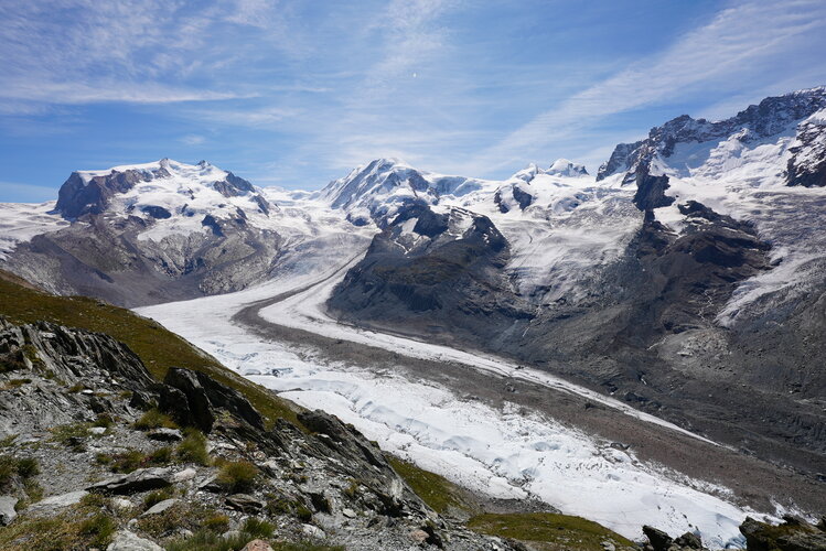
Sea-level rise is arguably one of the most serious consequences of the climate crisis. While using satellite data to monitor how the height of the sea is changing provides critical evidence for decision-making, satellites are also essential to measuring the individual components, such as seawater temperature and glacier melt, that contribute to the overall rise. Confidence in the accuracy of these separate measures is key. ESA-funded research now confirms that the figures match up.
15. jednání KRS
10.2.2022 10:41 ČÚZK - předpisy a opatření Dne 2. března 2022 proběhne distančně patnácté jednání Koordinační rady správců DMVS a DTM.15. jednání KRS
10.2.2022 10:41 ČÚZK - předpisy a opatření Dne 2. března 2022 proběhne distančně patnácté jednání Koordinační rady správců DMVS a DTM.Společná mapová aplikace pro celý mikroregion. Šternbersko ukazuje, jakým směrem se mohou svazky obcí vydat (TZ)
10.2.2022 8:19 GISportal.cz
Mapové aplikace s přímým vstupem do katastru nemovitostí, pasporty veřejného osvětlení či inženýrských sítí má v Česku velké množství měst a obcí. Své využití však najdou i u větších územních celků, například v rámci mikroregionů. Jedním z prvních takových je Mikroregion Šternbersko, kde mohou ze společné mapové aplikace těžit třeba při územním plánování. Využití najde ale i při dalších […]
The post Společná mapová aplikace pro celý mikroregion. Šternbersko ukazuje, jakým směrem se mohou svazky obcí vydat (TZ) appeared first on GISportal.cz.
APGEO - APG na konferenci MVPBIM 2022
10.2.2022 1:00 Asociace podnikatelů v geomatice Účastnili jsme se konference MVPBIM 2022.16. kartografický den Olomouc - 25.2.2022 [Knihovna geografie, byTopic]
10.2.2022 0:00 Katedra aplikované geoinformatiky a kartografie Přf UK Každoroční akce České kartografické společnosti se bude konat v Olomouci 25. února 2022, tentokrát na téma "Kartografie a kultura". Všichni se zájmem o mapy a kulturu jsou vítáni.New Commercial BVLOS Milestone - Longest Distance Allowed by FAA at 12 Miles
9.2.2022 20:26 GISCafe.com Webcasts-Webinars DAYTONA BEACH, Fla., Feb. 09, 2022 (GLOBE NEWSWIRE) -- Censys Technologies and Soaring Eagle Technologies, the leading commercial Beyond Visual …Satellogic Joins Ursa Space's Virtual Constellation and Partner Network
9.2.2022 20:26 GISCafe.com Webcasts-Webinars ITHACA, N.Y., Feb. 9, 2022 — (PRNewswire) — Ursa Space Systems, a global satellite intelligence infrastructure provider, has …New web tool digs into development decisions and flooding
9.2.2022 19:01 GISCafe.com Webcasts-Webinars Interactive tool reveals how the area's infrastructure will fare in a wetter futureCHARLOTTESVILLE, Va., Feb. 8, 2022 — (PRNewswire) — …
Annual TomTom Traffic Index: the World at the Pace of the Pandemic
9.2.2022 19:01 GISCafe.com Webcasts-Webinars Global congestion level in 2021 remains 10% lower than pre-COVID times (2019)World’s most congested city in 2021 is Istanbul, Turkey (Congestion …3 innovative solutions selected in "Pitch the Press" at Geo Week 2022
9.2.2022 19:01 GISCafe.com Webcasts-Webinars Tools for reality capture, collaboration and data visualization were chosen among 16 competing products.DENVER, Feb. 8, 2022 — (PRNewswire) …
Metricell Are Awarded New Digital Asset Management Platform Pilot
9.2.2022 18:59 GISCafe.com Webcasts-Webinars Horsham, United Kingdom, 09 February 2022: Metricell are pleased to have been selected for the Digital Connectivity Infrastructure Accelerator (DCIA) …Velodyne Lidar Wins Patent Challenge Brought by Quanergy in Federal Circuit Court of Appeals
9.2.2022 18:59 GISCafe.com Webcasts-Webinars U.S. Ninth Circuit Court of Appeals Upholds Validity of Velodyne’s U.S. Patent 7,969,558SAN JOSE, Calif. — (BUSINESS WIRE) — February …
Kratos Wins $20 Million International Drone Contract for Production Aircraft, Support Equipment, and Services
9.2.2022 18:59 GISCafe.com Webcasts-Webinars SAN DIEGO, Feb. 09, 2022 (GLOBE NEWSWIRE) -- Kratos Defense & Security Solutions, Inc. (Nasdaq: KTOS), a leading National Security …Trimble Announces Fourth Quarter and Full Year 2021 Results and Initiates 2022 Guidance
9.2.2022 18:59 GISCafe.com Webcasts-Webinars - Record annualized recurring revenue of $1.41 billion, up 9 percent and up 12 percent on an organic basisSUNNYVALE, Calif., Feb. 9, 2022 — …
Global possibilities in location-based data analysis from Canadian tech company, Sparkgeo
9.2.2022 18:59 GISCafe.com Webcasts-Webinars VANCOUVER, British Columbia, Feb. 09, 2022 (GLOBE NEWSWIRE) -- Sparkgeo, a Canadian-owned geospatial consulting company who has been gaining quiet …Podrobnosti o Leica Tour 2022, která letos začne 28. února v Liberci
9.2.2022 14:39 ZeměměřičFirma Gefos, která je v České republice prodejcem měřické techniky Leica Geosystems, zveřejnila detaily letošní roadshow Leica Tour 2022. První město, ve kterém novinky Leica Geosystems budou představeny, je Liberec v pondělí 28. února. (Všechna místa Leica Tour 2022 máme zde.) Ačkoliv je akce zdarma, pořadatelé prosí, zda byste se jim mohli ozvat, aby věděli, kolik mají připravit […]
The post Podrobnosti o Leica Tour 2022, která letos začne 28. února v Liberci appeared first on Zeměměřič.
EUSPA launches testing campaign for INAV improvements implementation
9.2.2022 13:08 European GNSS Agency Open Service Signal-In-Space Interface Control Document (OS SIS ICD) Issue 2.0 contains the publicly available information on the Galileo Signal-In-Space.")
The European Union Agency for the Space Programme (EUSPA) is launching a testing campaign for INAV improvements implementation and hereby invites external stakeholders to express their interest in participating in such testing campaign.
The testing will cover any of the three I/NAV improvements (SSP, FEC-2, RedCED), that will be tested in laboratory using simulated realistic scenarios, including open sky as well as impaired environments. The tests will allow the participants to have confirmation of the correct implementation of the OSSISICD 2.0. In case of specific interest, legacy receivers (e.g. not implementing I/NAV improvements) could be also tested, solely at the scope of confirming that they are not impacted anyhow by the introduction of the new I/NAV capabilities (backward compatibility is in any case guaranteed “by design” for any receiver that is fully compliant with the Galileo OS SIS ICD provisions, and referring in particular to section 4.1.2).
The characteristics of the testing campaign are described here.
The interested participants may be invited to provide their product(s) before 15 March, 1 May or 1 August to the premises indicated below according to the terms and conditions that will be communicated by the agency and be ready to provide any remote technical assistance needed during the testing as well as all the necessary interface documentation required for the testing. Any further detailed provision, including the possibility to provide the testing laboratories with ad-hoc receiver development platforms facilitating the testing activities, will be discussed with the interested participants.
The tests will be executed at the laboratories of the European Commission’s Joint Research Centre in Ispra, Italy, and of the European Space Agency ESA/ESTEC in Noordwijk, The Netherlands. Each applicant will be assigned by EUSPA to any of the two laboratories depending on the specific conditions and availability.
Testing is currently foreseen to be done in three batches, starting on 15 March, 1 May and 1 August 2022. The EUSPA reserves the right to change the scope, and timeline of the procedure.
Express your interest
If you are interested in participating in the testing campaign above, please express your interest by sending an email before 25/02/2022, 17:00 (Prague local time) to the following email address: market@euspa.europa.eu. The subject of the email shall be “INAV improvements implementation testing campaign”.
Media note: This feature can be republished without charge provided the European Union Agency for the Space Programme (EUSPA) is acknowledged as the source at the top or the bottom of the story. You must request permission before you use any of the photographs on the site. If you republish, we would be grateful if you could link back to the EUSPA website (http://www.euspa.europa.eu).
EUSPA launches testing campaign for INAV improvements implementation
9.2.2022 13:08 European GNSS AgencyThe European Union Agency for the Space Programme (EUSPA) is launching a testing campaign for INAV improvements implementation and hereby invites external stakeholders to express their interest in participating in such testing campaign.
The testing will cover any of the three I/NAV improvements (SSP, FEC-2, RedCED), that will be tested in laboratory using simulated realistic scenarios, including open sky as well as impaired environments. The tests will allow the participants to have confirmation of the correct implementation of the OSSISICD 2.0. In case of specific interest, legacy receivers (e.g. not implementing I/NAV improvements) could be also tested, solely at the scope of confirming that they are not impacted anyhow by the introduction of the new I/NAV capabilities (backward compatibility is in any case guaranteed “by design” for any receiver that is fully compliant with the Galileo OS SIS ICD provisions, and referring in particular to section 4.1.2).
The characteristics of the testing campaign are described here.
The interested participants may be invited to provide their product(s) before 15 March, 1 May or 1 August to the premises indicated below according to the terms and conditions that will be communicated by the agency and be ready to provide any remote technical assistance needed during the testing as well as all the necessary interface documentation required for the testing. Any further detailed provision, including the possibility to provide the testing laboratories with ad-hoc receiver development platforms facilitating the testing activities, will be discussed with the interested participants.
The tests will be executed at the laboratories of the European Commission’s Joint Research Centre in Ispra, Italy, and of the European Space Agency ESA/ESTEC in Noordwijk, The Netherlands. Each applicant will be assigned by EUSPA to any of the two laboratories depending on the specific conditions and availability.
Testing is currently foreseen to be done in three batches, starting on 15 March, 1 May and 1 August 2022. The EUSPA reserves the right to change the scope, and timeline of the procedure.
Express you interest
If you are interested in participating in the testing campaign above, please express your interest by sending an email before 25/02/2022, 17:00 (Prague local time) to the following email address: market@euspa.europa.eu. The subject of the email shall be “INAV improvements implementation testing campaign”.
Media note: This feature can be republished without charge provided the European Union Agency for the Space Programme (EUSPA) is acknowledged as the source at the top or the bottom of the story. You must request permission before you use any of the photographs on the site. If you republish, we would be grateful if you could link back to the EUSPA website (http://www.euspa.europa.eu).
Vrchní referent / rada – investiční referent v ekonomicko-správním oddělení Katastrálního úřadu pro
9.2.2022 12:55 ČÚZK - volná místa Katastrální úřad pro Zlínský kraj vypisuje výběrové řízení na místo Vrchní referent / rada – investiční referent v ekonomicko-správním oddělení Katastrálního úřadu proVrchní referent / rada – investiční referent v ekonomicko-správním oddělení Katastrálního úřadu pro
9.2.2022 12:55 ČÚZK - předpisy a opatření Katastrální úřad pro Zlínský krajvypisuje výběrové řízení na místo
Vrchní referent / rada – investiční referent v ekonomicko-správním oddělení Katastrálního úřadu pro Zlínský kraj
Vrchní referent / rada – investiční referent v ekonomicko-správním oddělení Katastrálního úřadu pro
9.2.2022 12:55 ČÚZK /Urady/Katastralni-urady/Katastralni-urady/Katastralni-urad-pro-Zlinsky-kraj/Uredni-deska/Oznameni-a-jina-uredni-sdeleni/Volna-mista/DMS/Vrchni-referent-rada-–-investicni-referent-v-ekoVyužití 3D digitálního modelu Prahy v mezinárodní urbanistické soutěži
9.2.2022 12:50 blog ARCDATA Začátkem prosince byly vyhlášeny výsledky mezinárodního urbanistického soutěžního workshopu „FLORENC 21“. Výběru vítěze předcházelo hodnocení odborné poroty a přizvaných expertů, kteří k tomu mimo jiné využili aplikaci pro zobrazení soutěžních návrhů ve 3D modelu Prahy, vyvinutou pražským Institutem plánování a rozvoje (IPR Praha).Rámcový harmonogram klíčových kroků při budování IS DMVS
9.2.2022 11:42 ČÚZK - předpisy a opatření Zveřejněn rámcový harmonogram klíčových kroků při budování IS DMVS. Harmonogram je určen pro externí subjekty připravující se na propojení s IS DMVS/DTM (obce, vlastníky a správce dopravní a technické infrastruktury a další).20210209_Vedoucí právního oddělení - odborný rada
9.2.2022 10:49 ČÚZK - předpisy a opatření Katastrální úřad pro Středočeský kraj - Katastrální pracoviště Praha-východ Vyhlášení výběrového řízení: Vedoucí právního oddělení - odborný rada V části "Úřední deska", v sekci "Oznámení a jiná úřední sdělení" bylo vystaveno "Oznámení o vyhlášení výběrového řízení na obsazení služebního místa Vedoucí právního oddělení - odborný rada"20210209_Vedoucí právního oddělení - odborný rada
9.2.2022 10:49 ČÚZK /Urady/Katastralni-urady/Katastralni-urady/Katastralni-urad-pro-Stredocesky-kraj/Katastralni-pracoviste/KP-Praha-vychod/O-uradu/Aktuality/20210113_odborny-rada,-reditel-Katastralniho-(3)Vedoucí právního oddělení - odborný rada
9.2.2022 10:45 ČÚZK - předpisy a opatření Katastrální úřad pro Středočeský kraj - Katastrální pracoviště Praha-východvypisuje výběrové řízení na místo Vedoucí právního oddělení - odborný rada
Vedoucí právního oddělení - odborný rada
Vedoucí právního oddělení - odborný rada
9.2.2022 10:45 ČÚZK /Urady/Katastralni-urady/Katastralni-urady/Katastralni-urad-pro-Stredocesky-kraj/Uredni-deska/Oznameni-a-jina-uredni-sdeleni/Volna-mista/Vedouci-pravniho-oddeleni-odborny-radaVedoucí právního oddělení - odborný rada
9.2.2022 10:45 ČÚZK - volná místa Katastrální úřad pro Středočeský kraj - Katastrální pracoviště Praha-východ vypisuje výběrové řízení na místo Vedoucí právního oddělení - odborný radaWhy startups should consider Flutter for mobile app development?
9.2.2022 10:21 Siemens Industry SoftwareWith the accessibility of famous systems and devices available like Ionic, Xamarin, and React Native,...
The post Why startups should consider Flutter for mobile app development? appeared first on Siemens Blog Network.
ESA hosts new office to coordinate global climate modelling push
9.2.2022 9:55 ESA Observing the Earth
Climate models are an important tool for scientists to understand our past climate and provide projections of future change. As such, they are in increasing demand as part of efforts to avert global warming and reduce risks associated with environmental change. To meet this demand, the World Climate Research Programme will open a new international office in the United Kingdom on 1 March 2022 that will coordinate the programme’s Climate Model Intercomparison Project.
Digitalizace pasportu komunikací
9.2.2022 8:09 GISportal.cz
Pasport pozemních komunikací je evidence pozemních komunikací vedená jejich správci. Pasporty mohou sloužit správcům a vlastníkům komunikací v jejich efektivní správě, zejména jsou-li v digitalizované podobě, nejlépe pak v geografickém informačním systému. To může být finančně nákladné, což představuje zejména pro malé obce určitou překážku. Pasport využijí i občané a jiné soukromé subjekty Dobře zpracovaný pasport v GIS […]
The post Digitalizace pasportu komunikací appeared first on GISportal.cz.
referent KN – vedení katastrální mapy, PT 10
9.2.2022 7:53 ČÚZK /Urady/Katastralni-urady/Katastralni-urady/Katastralni-urad-pro-hlavni-mesto-Prahu/Uredni-deska/Oznameni-a-jina-uredni-sdeleni/Volna-mista/DMS/referent-KN-–-vedeni-katastralni-mapy,-PT-10referent KN – vedení katastrální mapy, PT 10
9.2.2022 7:53 ČÚZK - předpisy a opatření Katastrální úřad pro hlavní město Prahu - Katastrální pracoviště Prahavypisuje výběrové řízení na místo
referent KN – vedení katastrální mapy, PT 10
referent KN – vedení katastrální mapy, PT 10
9.2.2022 7:53 ČÚZK - předpisy a opatření Katastrální úřad pro hlavní město Prahu Katastrální pracoviště Prahavypisuje výběrové řízení na místo
referent KN – vedení katastrální mapy, PT 10
referent KN – vedení katastrální mapy, PT 10
9.2.2022 7:53 ČÚZK - volná místa Katastrální úřad pro hlavní město Prahu - Katastrální pracoviště Praha vypisuje výběrové řízení na místo referent KN – vedení katastrální mapy, PT 10vrchní referent/rada – obnova katastrálního operátu 3020
9.2.2022 6:28 ČÚZK - volná místa Katastrální úřad pro Olomoucký kraj - technický odbor vypisuje výběrové řízení na místo vrchní referent/rada – obnova katastrálního operátu 3020vrchní referent/rada – obnova katastrálního operátu 3020
9.2.2022 6:28 ČÚZK - předpisy a opatření Katastrální úřad pro Olomoucký kraj - technický odborvypisuje výběrové řízení na místo
vrchní referent/rada – obnova katastrálního operátu 3020
vrchní referent/rada – obnova katastrálního operátu 3020
9.2.2022 6:28 ČÚZK /Urady/Katastralni-urady/Katastralni-urady/Katastralni-urad-pro-Olomoucky-kraj/Uredni-deska/Oznameni-a-jina-uredni-sdeleni/Volna-mista/vrchni-referent-rada-–-obnova-katastralniho-operatAPGEO - AZIMUT CZ s.r.o. novým členem APG
9.2.2022 1:00 Asociace podnikatelů v geomatice AZIMUT CZ s.r.o. zastoupena Ing. Jiřím Blábolem je novým členem APG.Přednáška Huga Poelmana
8.2.2022 19:46 Katedra geoinformatiky UP OlomoucV rámci dalšího KGItalku se vám speciální host Hugo Poelman, který působí přímo v Evropské komisi (DG REGIO – Policy Development and Economic Analysis) představí problematiku EU policies v propojení s GIS. Těšte se, bude to zajímavé. Tak se nezapomeňte připojit, záznam opět bohužel nebude. Budeme se těšit. Podrobnosti zde: Hugo Poelman (Evropská […]
The post Přednáška Huga Poelmana appeared first on Katedra geoinformatiky.
AECCafe Voice Industry Predictions for 2022 Part 2
8.2.2022 19:23 Bentley SystemsPressCoverage
AECCafe, USA
Read the articleViasat Executive Chairman, Mark Dankberg and Former NASA Administrator and Current Viasat Board Member, Jim Bridenstine, to Deliver Keynote Presentation at SmallSat Symposium 2022
8.2.2022 19:10 GISCafe.com Webcasts-Webinars Live Keynote will be Broadcast for Free on February 9, 2022 at 12:00pm Pacific TimeCARLSBAD, Calif., Feb. 8, 2022 — (PRNewswire) — …
Innoviz Technologies Announces Compliance with Critical Automotive-Grade Standard, Streamlining Adoption by Leading Automakers Pursuing Automated Driving
8.2.2022 19:10 GISCafe.com Webcasts-Webinars Innoviz achieves compliance with IATF 16949:2016 for its R&D and manufacturing facilities, essential for seamless integration with consumer vehicle …Nearmap Appoints General Managers in North America to Support Vertical Go-to-Market Strategy Growth and Success
8.2.2022 19:10 GISCafe.com Webcasts-Webinars SALT LAKE CITY, Feb. 08, 2022 (GLOBE NEWSWIRE) -- Leading aerial imagery and data intelligence provider Nearmap has appointed Elizabeth Del Ferro, …Monitoring crop health across the Netherlands
8.2.2022 17:19 ESA Observing the Earth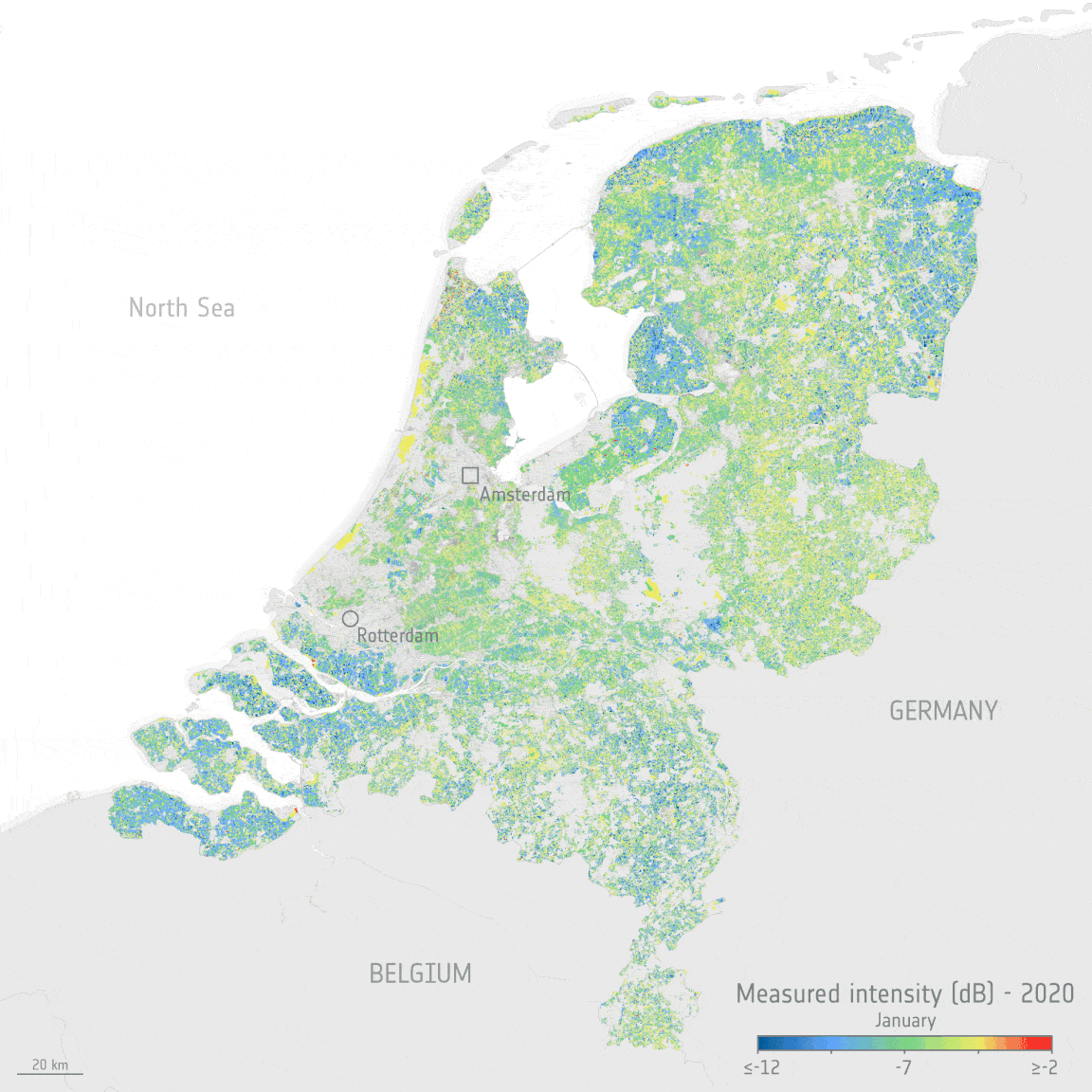
The Copernicus Sentinel satellite missions measure and image our planet in different ways to return a wealth of complementary information so that we can understand and track how our world is changing, and how to better manage our environment and resources. Thanks to the benefits of different types of data from two particular Copernicus Sentinel missions and an ingenious new dataset tool, people working in the agriculture sector, but who are not satellite data experts, can monitor the health and development of crops, right down to each crop in individual fields.
Digital tools have enabled a quick response to clients comments and requirements
8.2.2022 17:16 Bentley SystemsPressCoverage
Smart Water Magazine, Southern Europe
Read the articleAEC industry users choose winners of Construction Computing Awards
8.2.2022 17:02 Bentley SystemsPressCoverage
Graphic Speak, USA
Read the articleEarthCam 4D is like a time machine for construction projects
8.2.2022 16:49 Bentley SystemsPressCoverage
GeoWeek News, USA
Read the articleWSDP na zkoušku
8.2.2022 12:35 Dálkový přístup k údajům KN ČR Vážení uživatelé,webové služby dálkového přístupu na zkoušku jsou opět dostupné.
WSDP na zkoušku
8.2.2022 12:35 ČÚZK - předpisy a opatření Vážení uživatelé,webové služby dálkového přístupu na zkoušku jsou opět dostupné.
Zveřejnění obsahu informací poskytnutých na žádost dle zákona č. 106/1999 Sb. za rok 2022
8.2.2022 11:30 ČÚZK - předpisy a opatření Katastrální úřad pro Ústecký krajzveřejňuje obsah informace poskytnutých na žádost dle zákona č. 106/1999 Sb. za rok
2022
Zveřejnění obsahu informací poskytnutých na žádost dle zákona č. 106/1999 Sb. za rok 2022
8.2.2022 11:30 ČÚZK /Urady/Katastralni-urady/Katastralni-urady/Katastralni-urad-pro-Ustecky-kraj/Casto-hledane-informace/Poskytovani-informaci-106-1999-Sb/Zverejneni-obsahu-informaci-poskytnutych-na-za-(1)/Zverejneni-obsahu-informaci-poskytnutych-na-za-(4)Nedostupné produkční prostředí ISÚI
8.2.2022 10:01 ČÚZK /ruian/Editacni-agendovy-system-ISUI/Provozni-informace-a-odstavky/Archiv-PROD/Nedostupne-produkcni-prostredi-ISUI-(31)Odborný referent/Vrchní referent – oddělení právních vztahů k nemovitostem
8.2.2022 9:04 ČÚZK /Urady/Katastralni-urady/Katastralni-urady/Katastralni-urad-pro-Karlovarsky-kraj/Uredni-deska/Oznameni-a-jina-uredni-sdeleni/Volna-mista/DMS/Odborny-referent-Vrchni-referent-–-oddeleni-pravniOdborný referent/Vrchní referent – oddělení právních vztahů k nemovitostem
8.2.2022 9:04 ČÚZK - předpisy a opatření Katastrální úřad pro Karlovarský kraj Katastrální pracoviště Karlovy Varyvypisuje výběrové řízení na místo
Odborný referent/Vrchní referent – oddělení právních vztahů k nemovitostem
Odborný referent/Vrchní referent – oddělení právních vztahů k nemovitostem
8.2.2022 9:04 ČÚZK - volná místa Katastrální úřad pro Karlovarský kraj Katastrální pracoviště Karlovy Vary vypisuje výběrové řízení na místo Odborný referent/Vrchní referent – oddělení právních vztahů k nemovitostemVexcel Introduces MapControl SDK to Help Developers Integrate the World's Largest Aerial Imagery Program into Applications
8.2.2022 9:00 GISCafe.com Webcasts-Webinars New toolkit enables developers to easily add aerial imagery, 3D measurements, additional data sets, and more into their applicationsCENTENNIAL, …
GeoKARTO 2022 (pozvánka)
8.2.2022 8:58 GISportal.cz
Organizačný výbor zve na medzinárodnú konferenciu GeoKARTO 2022, ktorá sa uskutoční 8. – 9. septembra 2022 v priestoroch Prírodovedeckej fakulty Univerzity Komenského v Bratislave. Konferenciu organizuje Kartografická spoločnosť SR v spolupráci s Katedrou fyzickej geografie a geoinformatiky, Prírodovedeckej fakulty UK v Bratislave a Geografickým ústavom Slovenskej akadémie vied, v. v. i. Podujatie je organizovaná každé dva roky v spolupráci s […]
The post GeoKARTO 2022 (pozvánka) appeared first on GISportal.cz.
APGEO - Renesance letecké fotogrammetrie v České republice
8.2.2022 1:00 Asociace podnikatelů v geomatice Webinář Renesance letecké fotogrammetrie v České republice se bude konat 21. března 2022 od 15:00!How to Make a Better Dam Add Recycled Plastic says Bentley Student Showcase Winner
7.2.2022 22:15 Bentley SystemsPressCoverage
Engineering.com, USA
Read the articleDesign Construction of Worlds Tallest Rail Pier Girder Bridge
7.2.2022 21:48 Bentley SystemsPressCoverage
Construction Times, India
Read the articlePt Wijaya Karya Employs BIM Methodology
7.2.2022 21:32 Bentley SystemsPressCoverage
CE&CR, India
Read the articleIdeaThon 5G
7.2.2022 21:14 Katedra geoinformatiky UP OlomoucPřipojte se k akci s názvem 5G thon, která má podtitul: IdeaThon zaměřený na rozvoj využití 5G sítě pro Smart Cities řešení v ČR. V kostce se jedná o soutěž ( = ideathon) a sérii odborných akcí s tematikou využití 5G sítí v konceptu rozvoje Smart Cities. Akce je rozdělena na dvě části: 15. 2. 2022 – zahájení […]
The post IdeaThon 5G appeared first on Katedra geoinformatiky.
Tantek 4D successfully manages construction of tallest modular built high rise in the world
7.2.2022 20:49 Bentley SystemsPressCoverage
EPC World, India
Read the articleFrom standard to multinational membership for ACCA Software
7.2.2022 20:31 buildingSMART.orgLondon, U.K. - February 7, 2022 - buildingSMART International is announcing the upgrade from standard to multinational membership for ACCA Software. This announcement coincides with their accelerated developments for the buildingSMART Data Dictionary (bSDD), IDS (Information Delivery Specification) and other supportining services to the Technical Roadmap from buildingSMART. This announcement means ACCA will also be members of…
The post From standard to multinational membership for ACCA Software appeared first on buildingSMART International.
From standard to multinational membership for ACCA Software
7.2.2022 20:31 buildingSMART.orgLondon, U.K. - February 7, 2022 - buildingSMART International is announcing the upgrade from standard to multinational membership for ACCA Software. This announcement coincides with their accelerated developments for the buildingSMART Data Dictionary (bSDD), IDS (Information Delivery Specification) and other supportining services to the Technical Roadmap from buildingSMART. This announcement means ACCA will also be…
The post From standard to multinational membership for ACCA Software appeared first on buildingSMART International.
Vexcel Announces Image Services for ArcGIS
7.2.2022 19:25 GISCafe.com Webcasts-Webinars ArcGIS users get faster access to the world's largest aerial imagery program to enhance their workflowsCENTENNIAL, Colo., Feb. 6, 2022 — …
Kratos Wins $14 Million in Contract Awards for Drone System Logistics Support, Spares, and Consumables
7.2.2022 19:25 GISCafe.com Webcasts-Webinars SAN DIEGO, Feb. 07, 2022 (GLOBE NEWSWIRE) -- Kratos Defense & Security Solutions, Inc. (NASDAQ: KTOS), a leading National Security Solutions …Unacast Now Offers Aggregated Location Data from 80+ Countries
7.2.2022 19:25 GISCafe.com Webcasts-Webinars Location Data and Analytics Firm Offers Expanded Human Mobility DataNEW YORK, Feb. 7, 2022 — (PRNewswire) — Unacast, a global …
Spiio Launches Major New Software Release and Doubles Customer Count as Demand for Next-Gen Irrigation Management Platform Takes Off
7.2.2022 19:25 GISCafe.com Webcasts-Webinars SAN DIEGO, Feb. 07, 2022 (GLOBE NEWSWIRE) -- GCSAA Conference -- Spiio, pioneering a new era in water conservation, precision irrigation, and …Odborný referent v oddělení aktualizace KN č.1 na Katastrálním pracovišti Znojmo
7.2.2022 12:45 ČÚZK /Urady/Katastralni-urady/Katastralni-urady/Katastralni-urad-pro-Jihomoravsky-kraj/Uredni-deska/Oznameni-a-jina-uredni-sdeleni/Volna-mista/DMS/Odborny-referent-v-oddeleni-aktualizace-KN-c-1-naOdborný referent v oddělení aktualizace KN č.1 na Katastrálním pracovišti Znojmo
7.2.2022 12:45 ČÚZK - předpisy a opatření Katastrální úřad pro Jihomoravský kraj Katastrální pracoviště Znojmovypisuje výběrové řízení na místo
Odborný referent v oddělení aktualizace KN č.1 na Katastrálním pracovišti Znojmo
Odborný referent v oddělení aktualizace KN č.1 na Katastrálním pracovišti Znojmo
7.2.2022 12:45 ČÚZK - volná místa Katastrální úřad pro Jihomoravský kraj Katastrální pracoviště Znojmo vypisuje výběrové řízení na místo Odborný referent v oddělení aktualizace KN č.1 na Katastrálním pracovišti ZnojmoNedostupnost WSDP na zkoušku ve dnech 8.2. - 10.2.2022
7.2.2022 11:06 ČÚZK - předpisy a opatření Vážení uživatelé,oznamujeme, že z technických důvodů budou od úterý 8.2.2022 do čtvrtka 10.2.2022 nedostupné webové služby dálkového přístupu na zkoušku.
Zprovoznění prostředí na zkoušku bude oznámeno samostatnou zprávou.
Za komplikace tímto způsobné se omlouváme a děkujeme za pochopení.
Nedostupnost WSDP na zkoušku ve dnech 8.2. - 10.2.2022
7.2.2022 11:06 ČÚZK /Aplikace-DP-do-KN/Aplikace-DP-do-KN/Archiv-DP/346939Nedostupnost WSDP na zkoušku ve dnech 8.2. - 10.2.2022
7.2.2022 11:06 Dálkový přístup k údajům KN ČR Vážení uživatelé,oznamujeme, že z technických důvodů budou od úterý 8.2.2022 do čtvrtka 10.2.2022 nedostupné webové služby dálkového přístupu na zkoušku.
Zprovoznění prostředí na zkoušku bude oznámeno samostatnou zprávou.
Za komplikace tímto způsobné se omlouváme a děkujeme za pochopení.
Geoinformace ve veřejné správě 2022 (pozvánka)
7.2.2022 8:40 GISportal.cz
Česká asociace pro geoinformace zve na tradiční konferenci Geoinformace ve veřejné správě 2022, která se uskuteční v prezenční formě 2.–3. května 2022 na Novotného lávce v Praze (v případě nepříznivé epidemiologické situace bude konference přesunuta do online prostředí). Hlavními tématy letošního ročníku konference Geoinformace ve veřejné správě 2022 jsou: DMVS, DTM, Digitalizace stavebního řízení […]
The post Geoinformace ve veřejné správě 2022 (pozvánka) appeared first on GISportal.cz.
Plánovaný výpadek počítačové sítě - pátek 11.2.2022 [Knihovna geografie, byTopic]
7.2.2022 0:00 Katedra aplikované geoinformatiky a kartografie Přf UK V pátek 11.2.2022 bude knihovna geografie otevřena pouze do 13:00, poněvadž poté dojde k odstávce fakultního firewallu a v jejím důsledku nebudou dostupné ICT služby fakulty.16. kartografický den Olomouc (program a registrace)
6.2.2022 21:26 GISportal.czŠestnáctý ročník kartografických dnů v Olomouci, o kterém jsme před měsícem informovali, už zná svou přesnou podobu. Tento tradiční seminář, letos zaměřený na využití kartografie v kultuře, se uskuteční v klasické prezenční formě na půdě Přírodovědecké fakulty Univerzity Palackého v Olomouci. Máme k dispozici přesný program a na webu kartografickyden.upol.cz již běží bezplatná registrace účastníků. […]
The post 16. kartografický den Olomouc (program a registrace) appeared first on GISportal.cz.
První výsledky SLDB 2021
6.2.2022 17:31 GISportal.cz
ČSÚ zveřejnil první výsledky sčítání lidu, domů a bytů 2021 v České republice a krajích. Jedná se o 19 tabulek a nám nezbývá než jen doufat, že další data budou také brzy zveřejněna. Vývoj počtu obyvatel České republiky a krajů v letech 1991 až 2021 Obyvatelstvo podle státního občanství a pohlaví v letech 1991 až […]
The post První výsledky SLDB 2021 appeared first on GISportal.cz.
TurboCAD MAC Designer 2D 12 CZ v akční ceně
5.2.2022 17:54 ŠPINAR - softwareVážení zákazníci, dovolujeme si Vám nabídnout program TurboCAD MAC Designer 2D kreslení v češtině. v akční ceně do 12.2..2022.
The post TurboCAD MAC Designer 2D 12 CZ v akční ceně appeared first on ŠPINAR – software.
TurboCAD MAC Designer 2D 12 CZ v akční ceně
5.2.2022 17:54 ŠPINAR - software Vážení zákazníci, dovolujeme si Vám nabídnout program TurboCAD MAC Designer 2D kreslení v češtině. v akční ceně do 12.2..2022.5 Best features of native app development
5.2.2022 8:30 Siemens Industry SoftwareNative mobile application development includes developing applications for specific mobile operating systems, and clients access...
The post 5 Best features of native app development appeared first on Siemens Blog Network.
BlackSky to Host Fourth Quarter and Full Year 2021 Results Conference Call
4.2.2022 19:08 GISCafe.com Webcasts-Webinars HERNDON, Va. — (BUSINESS WIRE) — February 3, 2022 —BlackSky Technology Inc. (“BlackSky” or the “Company”) (NYSE: BKSY) …
Intermap Announces Software Subscriptions in Europe
4.2.2022 19:08 GISCafe.com Webcasts-Webinars DENVER, Feb. 4, 2022 — (PRNewswire) — Intermap Technologies (TSX: IMP) (OTCQX: ITMSF) ("Intermap" or the "Company"), a global leader in …"GISCafe Voice Industry Predictions for 2022 – Part 3" by Susan Smith
4.2.2022 12:48 GISCafe.com Webcasts-WebinarsNew eruption at Krakatoa Volcano
4.2.2022 11:36 ESA Observing the Earth Image:
A new eruption started at the Anak Krakatoa volcano in Indonesia on 3 February 2022, as seen in this image captured by the Copernicus Sentinel-2 mission.
Image:
A new eruption started at the Anak Krakatoa volcano in Indonesia on 3 February 2022, as seen in this image captured by the Copernicus Sentinel-2 mission.
The European GNSS Service Centre is getting ready for next-gen Galileo services
4.2.2022 11:12 European GNSS Agency
The EU Agency for the Space Programme (EUSPA) publishes a procurement on the “Evolution of the European GNSS Service Centre (E-GSC) Infrastructure”. To encourage the widest participation possible, the Agency is organizing an industry day to present the details of the call on 15 February 2022 at 10.00.
A key link between Galileo and its users is the European GNSS Service Centre (GSC). Located in a fully secured environment outside Madrid, the GSC is at the heart of Galileo´s service provision. The centre serves as a single interface between Galileo and the users of the Galileo Open Service (OS), that is also contributing to the Galileo Search and Rescue Service. In the future, it will play a key role for Galileo´s differentiators such as the Galileo High Accuracy Service and the OS Navigation Message Authentication Service. As an integral part of EUSPA, the GSC is a centre of expertise, knowledge sharing, data and information dissemination.
With this important procurement, EUSPA is looking for a partner to provide services and supplies to support the Agency in shaping the future versions of the E-GSC infrastructure to enable the evolutions of several E-GNSS services. EUSPA is committed to promoting the widest participation possible by economic operators, including new entrants, in particular start-ups and SMEs. To do so, the agency is organizing an industry day on 15 February 2022 at 10.00 am to present the details of the procurement on “Evolution of the European GNSS Service Centre (E-GSC) Infrastructure”.
Participants will also have the opportunity to learn more about the mission of the GSC, the procurement documentation and the submission process.
To attend the event, please register here.
Media note: This feature can be republished without charge provided the European Union Agency for the Space Programme (EUSPA) is acknowledged as the source at the top or the bottom of the story. You must request permission before you use any of the photographs on the site. If you republish, we would be grateful if you could link back to the EUSPA website (http://www.euspa.europa.eu).
WSGP - Ukončení provozu služeb verze 2.8
4.2.2022 11:03 ČÚZK /Zememerictvi/Zememericke-cinnosti/Aktuality-pro-zememerice/2022/WSGP-Ukonceni-provozu-sluzeb-verze-2-8WSGP - Ukončení provozu služeb verze 2.8
4.2.2022 11:03 ČÚZK - RSS kanál pro zeměměřiče WSGP - Ukončení provozu služeb verze 2.8Vážení uživatelé webových služeb pro vyhotovitele a ověřovatele geometrických plánů,
upozorňujeme, že v dubnu 2022 (termín bude upřesněn) bude ukončen provoz webových služeb pro vyhotovitele a ověřovatele geometrických plánů verze 2.8. Od tohoto termínu budou v provozu pouze webové služby pro vyhotovitele a ověřovatele geometrických plánů verze 2.9.
S přechodem databáze ISKN na kódování UTF8 dojde v dubnu 2022 k úpravě exportu a importu VFK. Nově bude umožněno pouze kódování UTF8.
Za komplikace tímto způsobené se omlouváme a děkujeme za pochopení.
WSGP - Ukončení provozu služeb verze 2.8
4.2.2022 11:03 ČÚZK - předpisy a opatření Český úřad zeměměřický a katastrální zveřejnil novou aktualitu: WSGP - Ukončení provozu služeb verze 2.8Vážení uživatelé webových služeb pro vyhotovitele a ověřovatele geometrických plánů,
upozorňujeme, že v dubnu 2022 (termín bude upřesněn) bude ukončen provoz webových služeb pro vyhotovitele a ověřovatele geometrických plánů verze 2.8. Od tohoto termínu budou v provozu pouze webové služby pro vyhotovitele a ověřovatele geometrických plánů verze 2.9.
S přechodem databáze ISKN na kódování UTF8 dojde v dubnu 2022 k úpravě exportu a importu VFK. Nově bude umožněno pouze kódování UTF8.
Za komplikace tímto způsobené se omlouváme a děkujeme za pochopení.
Earth from Space: Batura Glacier
4.2.2022 10:00 ESA Observing the Earth
The Copernicus Sentinel-2 mission takes us over Batura Glacier – one of the largest and longest glaciers in the world, outside of the polar regions.
$3M Dpt. of Energy Grant Awarded to Design 'NitroNet' for SMARTFARM
4.2.2022 9:00 GISCafe.com Webcasts-Webinars PRINCETON, N.J., Jan. 31, 2022 — (PRNewswire) — Mark Zondlo, a Professor of Civil and Environmental Engineering at Princeton University …Silent Arrow® Autonomously Delivers 1,026 Pounds of Cargo in First Overseas Deployment
4.2.2022 9:00 GISCafe.com Webcasts-Webinars Allied Military Air Force C-130s Conduct Successful Cargo Delivery Operations Utilizing the Silent Arrow® GD-2000 in the Middle EastLOS …
Harmonogram státních závěrečných zkoušek (únor 2022)
4.2.2022 0:00 Geografický ústav MUByl zveřejněn harmonogram Státních závěrečných zkoušek, které se odehrají v únoru 2022.
Veřejné zakázky na údržbu melioračních staveb
4.2.2022 0:00 Státní pozemkový úřad Státní pozemkový úřad informuje dodavatele a případné zájemce o probíhající zadávací řízení k zavedení dynamického nákupního systému (dále také „DNS“) k Provádění údržby melioračních staveb ve správě SPÚ, že dodavatelům skončila dne 30. 01. 2022 ve 23:59 hodin lhůta pro podání žádostí o účast.Houghton College Adopts Aquiline Drones' Specialized Training in New 5-Year Deal
3.2.2022 19:27 GISCafe.com Webcasts-Webinars Private College First in New York State to Add Drone Pilot Course to CurriculumHOUGHTON, N.Y., Feb. 2, 2022 — (PRNewswire) — …
Maxar Extends Satellite Capacity Agreement with European Space Imaging and Space Imaging Middle East
3.2.2022 19:27 GISCafe.com Webcasts-Webinars WESTMINSTER, Colo., Feb. 3, 2022 — (PRNewswire) — Maxar Technologies (NYSE: MAXR) (TSX: MAXR), provider of comprehensive space …Woolpert Acquires eTrac Inc., a Vessel-Based Hydrographic Survey Firm Headquartered in California
3.2.2022 19:27 GISCafe.com Webcasts-Webinars This merger combines complementary marine technology products and services to better serve U.S. and international clients with integrated …Near Space Labs Brings Highest Resolution Geospatial Imagery Down to Lowest Cost - New 10-Centimeter Resolution Now Accessible with Stratospheric Balloons
3.2.2022 19:27 GISCafe.com Webcasts-Webinars Affordable price point broadens access to high-quality data needed to sharpen decisions about our planet delivered via zero-emission …Monitoring a vyhodnocování rizik v okolí dopravní infrastruktury s řešením od Unicorn Systems
3.2.2022 18:00 Unicorn Na čem nyní pracujeme v oblasti geoinformatiky? Mimo jiné spolu s partnery realizujeme komplexní řešení, které dokáže pomocí dronů detekovat potenciálně nebezpečné stromy v okolí jakékoliv dopravní infrastruktury. Více se dočtete v tiskové zprávě, která o našem projektu vyšla.
Odstávka Portálu ESKN
3.2.2022 15:50
ÚGKK SR
Dnes - 03.02.2022 - v čase od 20:30 do 22:30 hod. bude mimoriadna odstávka Portálu ESKN. Z uvedeného dôvodu nebudú v uvedenom čase dostupné elektronické služby katastra nehnuteľností pre verejnosť .
Již přes 37 000 registrovaných pilotů dronů v ČR
3.2.2022 14:37 UAVAV ČR je již přes 34 000 registrovaných provozovatelů dronů, přes 37 000 registrovaných pilotů, z toho 806 pilotů má zkoušky A2 v registračním systému Úřadu pro civilní letectví. Současně bylo více než 420 řízení k oprávnění ve specifické kategorii. Více ve článku zde: https://www.novinky.cz/ekonomika/clanek/registr-dronu-se-plni-nad-ocekavani-40386013
The post Již přes 37 000 registrovaných pilotů dronů v ČR appeared first on UAV Aliance pro bezpilotní letecký průmysl.