


zprávy
zdroje zpráv:Aktualizace prohlížecí služby WMTS ZABAGED®
17.2.2022 11:00 ČÚZK - Geoportál Aktualizace prohlížecí služby WMTS ZABAGED®Prohlížecí služba WMTS ZABAGED®, vytvořená za účelem poskytování podkladové mapy s rychlým překreslováním z předpřipravených mapových dlaždic, již poskytuje veškeré změny po lednové aktualizaci datové sady ZABAGED®.
Již dříve (souběžně s aktualizací) byly aktualizovány dynamické prohlížecí služby ZABAGED®, ZABAGED® (vizualizace nad ortofoto) ZABAGED® (vizualizace ZM10) poskytující obraz dat ZABAGED® přímo z publikační databáze.
Aktualizace prohlížecí služby WMTS ZABAGED®
17.2.2022 11:00 ČÚZK - Geoportál Aktualizace prohlížecí služby WMTS ZABAGED®Prohlížecí služba WMTS ZABAGED®, vytvořená za účelem poskytování podkladové mapy s rychlým překreslováním z předpřipravených mapových dlaždic, již poskytuje veškeré změny po lednové aktualizaci datové sady ZABAGED®.
Již dříve (souběžně s aktualizací) byly aktualizovány dynamické prohlížecí služby ZABAGED®, ZABAGED® (vizualizace nad ortofoto) ZABAGED® (vizualizace ZM10) poskytující obraz dat ZABAGED® přímo z publikační databáze.
Dokumentace k JVF DTM
17.2.2022 10:49 ČÚZK - předpisy a opatření Na Portálu JVF DTMDokumentace k JVF DTM
17.2.2022 10:49 ČÚZK - předpisy a opatření Na Portálu JVF DTM byla vystavena kompletní dokumentace aktualizované verze JVF DTM 1.4.2 (výstup projektu Technologické agentury ČR).4 Must-have features in android chat apps
17.2.2022 10:07 Siemens Industry SoftwareAs we definitely realize that the amount it is essential to remain updated with regards...
The post 4 Must-have features in android chat apps appeared first on Siemens Blog Network.
Aktualizace prohlížecí služby WMTS ZABAGED®
17.2.2022 10:00 ČÚZK - Geoportál Aktualizace prohlížecí služby WMTS ZABAGED®Prohlížecí služba WMTS ZABAGED®, vytvořená za účelem poskytování podkladové mapy s rychlým překreslováním z předpřipravených mapových dlaždic, již poskytuje veškeré změny po lednové aktualizaci datové sady ZABAGED®.
Již dříve (souběžně s aktualizací) byly aktualizovány dynamické prohlížecí služby ZABAGED®, ZABAGED® (vizualizace nad ortofoto) ZABAGED® (vizualizace ZM10) poskytující obraz dat ZABAGED® přímo z publikační databáze.
Historická ortofotomapa z 50.let se otevírá
17.2.2022 9:24 CENIA - národní geoportál INSPIRE Česká informační agentura životního prostředí (CENIA) společně s VGHMÚř Dobruška oznamuje změnu licenčních podmínek pro datovou sadu Historická ortofotomapa (50. léta). Datová sada je nyní dostupná široké veřejnosti pod licencí CC-BY 4.0 (Uveďte původ 4.0 Mezinárodní). Při každém použití těchto dat je tedy nutné uvést licenci CC-BY 4.0, název díla a autory díla v tomto tvaru: Historická...Uzavření kontaktního místa
17.2.2022 8:21 ČÚZK - předpisy a opatření Katastrální úřad pro Vysočinu - Katastrální pracoviště Žďár nad Sázavou zveřejnil novou aktualitu: Katastrální úřad pro Vysočinu, Katastrální pracoviště Žďár nad Sázavou oznamuje, že ode dne 21. 2. 2022 do odvolání bude Kontaktní místo Bystřice nad Pernštejnem z provozních důvodů uzavřeno.V případě potřeby se obracejte na podatelnu Katastrálního pracoviště Žďár nad Sázavou, se sídlem Strojírenská 8, 591 27 Žďár nad Sázavou.
Uzavření kontaktního místa
17.2.2022 8:21 ČÚZK /Urady/Katastralni-urady/Katastralni-urady/Katastralni-urad-pro-Vysocinu/Katastralni-pracoviste/KP-Zdar-nad-Sazavou/O-uradu/Aktuality/Uzavreni-kontaktniho-mista-(1)Uzavření kontaktního místa
17.2.2022 8:21 ČÚZK - předpisy a opatření Český úřad zeměměřický a katastrální - Katastrální pracoviště Žďár nad Sázavou zveřejnil novou aktualitu: Katastrální úřad pro Vysočinu, Katastrální pracoviště Žďár nad Sázavou oznamuje, že ode dne 21. 2. 2022 do odvolání bude Kontaktní místo Bystřice nad Pernštejnem z provozních důvodů uzavřeno.V případě potřeby se obracejte na podatelnu Katastrálního pracoviště Žďár nad Sázavou, se sídlem Strojírenská 8, 591 27 Žďár nad Sázavou.
Uzavření kontaktního místa
17.2.2022 8:21 ČÚZK - předpisy a opatření Český úřad zeměměřický a katastrální - Katastrální pracoviště Žďár nad Sázavou zveřejnil novou aktualitu: Katastrální úřad pro Vysočinu, Katastrální pracoviště Žďár nad Sázavou oznamuje, že ode dne 21. 2. 2022 do odvolání bude Kontaktní místo Bystřice nad Pernštejnem z provozních důvodů uzavřeno.V případě potřeby se obracejte na podatelnu Katastrálního pracoviště Žďár nad Sázavou, se sídlem Strojírenská 8, 591 27 Žďár nad Sázavou.
FARO Announces Fourth Quarter and Full Year Financial Results
17.2.2022 1:32 GISCafe.com Webcasts-Webinars LAKE MARY, Fla., Feb. 16, 2022 — (PRNewswire) — FARO® (Nasdaq: FARO), a leading global source for 3D measurement and imaging …TerraGo Joins the Esri ArcGIS® Marketplace with GeoPDF® Publisher for ArcGIS Pro
16.2.2022 23:11 GISCafe.com Webcasts-Webinars Washington D.C., February 14, 2022 — TerraGo Technologies, a leading provider of geospatial solutions to the US Department of Defense and other …EarthDaily Analytics Announces Imaging Payload Providers for the EarthDaily Satellite Constellation
16.2.2022 19:09 GISCafe.com Webcasts-Webinars VANCOUVER, BC, Feb. 16, 2022 — (PRNewswire) — EarthDaily Analytics Corp. ("EDA" or the "Company"), a vertically-integrated data …Mapa administrativního členění 2022
16.2.2022 16:53 Jihočeský krajV sekci Ke stažení je k dispozici aktualizovaná mapa administrativního členění k 1.1.2022 v rozměru mapy A1 za Jihočeský kraj.
Garmin announces fourth quarter and fiscal year 2021 results
16.2.2022 16:09 GISCafe.com Webcasts-Webinars Company reports record full year revenue and operating income and proposes dividend increaseSCHAFFHAUSEN, Switzerland — (BUSINESS WIRE) …
Geo Week 2022 Brings Together Geospatial and Built Worlds In-Person, Exceeds Expectations
16.2.2022 16:09 GISCafe.com Webcasts-Webinars Geospatial and built world professionals gathered last week for Geo Week, held February 6-8, 2022 at the Colorado Convention Center in Denver. Geo …GeoX partners with Sompo Japan to develop AI-based automated underwriting platforms
16.2.2022 16:09 GISCafe.com Webcasts-Webinars NEW YORK, Feb. 16, 2022 — (PRNewswire) — GeoX, a leader in supplying geospatial data to insurers, has today announced a partnership with …Dnes pořádal Dronetag online a offline workshop v DJI Telink k dálkové identifikaci dronů
16.2.2022 14:42 UAVADnes pořádal člen Aliance Dronetag online a offline workshop v DJI Telink k dálkové identifikaci dronů a také dnes aktuálně od EASA došlo opět k posunutí povinnosti dálkové identifikace dronů až od roku 2024. Nicméně standardy pro dálkovou identifikaci existují a je možné je využívat pro podpůrné účely už nyní. Celý stream workshopu je k […]
The post Dnes pořádal Dronetag online a offline workshop v DJI Telink k dálkové identifikaci dronů appeared first on UAV Aliance pro bezpilotní letecký průmysl.
20220216_Odborný / vrchní referent oddělení aktualizace GI KN
16.2.2022 11:07 ČÚZK - předpisy a opatření Katastrální úřad pro Středočeský kraj - Katastrální pracoviště Praha-východ Vyhlášení výběrového řízení: Odborný / vrchní referent oddělení aktualizace GI KN V části "Úřední deska", v sekci "Oznámení a jiná úřední sdělení" bylo vystaveno "Oznámení o vyhlášení výběrového řízení na obsazení služebního místa Odborný / vrchní referent oddělení aktualizace GI KN"20220216_Odborný / vrchní referent oddělení aktualizace GI KN
16.2.2022 11:07 ČÚZK /Urady/Katastralni-urady/Katastralni-urady/Katastralni-urad-pro-Stredocesky-kraj/Katastralni-pracoviste/KP-Praha-vychod/O-uradu/Aktuality/20220114_Odborny-vrchni-referent-oddeleni-aktu-(1)Odborný / vrchní referent oddělení aktualizace GI KN
16.2.2022 11:06 ČÚZK - předpisy a opatření Katastrální úřad pro Středočeský kraj - Katastrální pracoviště Praha-východvypisuje výběrové řízení na místo Odborný / vrchní referent oddělení aktualizace GI KN
Odborný / vrchní referent oddělení aktualizace GI KN
Rada / odborný rada – obnova katastrálního operátu v oddělení dokumentace KN Katastrálního pracovišt
16.2.2022 10:57 ČÚZK - volná místa Katastrální úřad pro Zlínský kraj Katastrální pracoviště Zlín vypisuje výběrové řízení na místo Rada / odborný rada – obnova katastrálního operátu v oddělení dokumentace KN Katastrálního pracovištRada / odborný rada – obnova katastrálního operátu v oddělení dokumentace KN Katastrálního pracovišt
16.2.2022 10:57 ČÚZK - předpisy a opatření Katastrální úřad pro Zlínský kraj Katastrální pracoviště Zlínvypisuje výběrové řízení na místo
Rada / odborný rada – obnova katastrálního operátu v oddělení dokumentace KN Katastrálního pracoviště Zlín
20220216_Odborný rada oddělení právních vztahů k nemovitostem
16.2.2022 10:54 ČÚZK - předpisy a opatření Katastrální úřad pro Středočeský kraj - Katastrální pracoviště Benešov zveřejnil novou aktualitu: Odborný rada oddělení právních vztahů k nemovitostem V části "Úřední deska", v sekci "Oznámení a jiná úřední sdělení" bylo vystaveno "Oznámení o vyhlášení výběrového řízení na obsazení služebního místa Odborný rada oddělení právních vztahů k nemovitostem"20220216_Odborný rada oddělení právních vztahů k nemovitostem
16.2.2022 10:54 ČÚZK /Urady/Katastralni-urady/Katastralni-urady/Katastralni-urad-pro-Stredocesky-kraj/Katastralni-pracoviste/KP-Benesov/O-uradu/Aktuality/20211220_Odborny-rada-oddeleni-pravnich-vztahu-(1)20220216_Odborný rada právního oddělení
16.2.2022 10:37 ČÚZK - předpisy a opatření Katastrální úřad pro Středočeský kraj - Katastrální pracoviště Praha-západ Vyhlášení výběrového řízení: Odborný rada právního oddělení V části "Úřední deska", v sekci "Oznámení a jiná úřední sdělení" bylo vystaveno "Oznámení o vyhlášení výběrového řízení na obsazení služebního místa Odborný rada právního oddělení"20220216_Odborný rada právního oddělení
16.2.2022 10:37 ČÚZK /Urady/Katastralni-urady/Katastralni-urady/Katastralni-urad-pro-Stredocesky-kraj/Katastralni-pracoviste/KP-Praha-zapad/O-uradu/Aktuality/20210922_Odborny-referent-oddeleni-aktualizace-(6)Odborný rada právního oddělení
16.2.2022 10:36 ČÚZK - volná místa Katastrální úřad pro Středočeský kraj - Katastrální pracoviště Praha-západ vypisuje výběrové řízení na místo Odborný rada právního odděleníOdborný rada právního oddělení
16.2.2022 10:36 ČÚZK - předpisy a opatření Katastrální úřad pro Středočeský kraj - Katastrální pracoviště Praha-západvypisuje výběrové řízení na místo Odborný rada právního oddělení
Odborný rada právního oddělení
Odborný/vrchní referent v oddělení aktualizace KN č.2 na Katastrálním pracovišti Znojmo
16.2.2022 10:01 ČÚZK /Urady/Katastralni-urady/Katastralni-urady/Katastralni-urad-pro-Jihomoravsky-kraj/Volna-mista/DMS/Odborny-vrchni-referent-v-oddeleni-aktualizace-KNOdborný/vrchní referent v oddělení aktualizace KN č.2 na Katastrálním pracovišti Znojmo
16.2.2022 10:01 ČÚZK - předpisy a opatření Katastrální úřad pro Jihomoravský kraj Katastrální pracoviště Znojmovypisuje výběrové řízení na místo
Odborný/vrchní referent v oddělení aktualizace KN č.2 na Katastrálním pracovišti Znojmo
Odborný/vrchní referent v oddělení aktualizace KN č.2 na Katastrálním pracovišti Znojmo
16.2.2022 10:01 ČÚZK - volná místa Katastrální úřad pro Jihomoravský kraj Katastrální pracoviště Znojmo vypisuje výběrové řízení na místo Odborný/vrchní referent v oddělení aktualizace KN č.2 na Katastrálním pracovišti ZnojmoG++ 2022 bude! (pozvánka)
16.2.2022 8:14 GISportal.cz
Kultovní akci nazvanou G++ každoročně pořádají studenti 1. ročníku magisterských studijních oborů Geodézie a kartografie a Geomatika z Fakulty stavební ČVUT v Praze. Tato tradice vznikla již v roce 1991 a koná se pravidelně, pauze s pauzami v období 1995 až 2001 a 2020 až 2021. Jedná se o neformální příležitost pro přátelská setkání a […]
The post G++ 2022 bude! (pozvánka) appeared first on GISportal.cz.
Výroční zpráva dle zákona č. 106/1999 Sb. za rok 2021
16.2.2022 7:52 ČÚZK - předpisy a opatření Katastrální úřad pro Ústecký krajvydává výroční zprávu úřadu za rok
2021
Výroční zpráva dle zákona č. 106/1999 Sb. za rok 2021
16.2.2022 7:52 ČÚZK /Urady/Katastralni-urady/Katastralni-urady/Katastralni-urad-pro-Ustecky-kraj/Vyrocni-zpravy/Vyrocni-zprava-dle-zakona-c-106-1999-Sb-za-rok-(4)Ouster Delivers on 2021 Guidance with $34 Million in Revenue and 27% Gross Margins; Q4 Revenue Up 53%; Aims to Double Revenue for 2022
16.2.2022 0:32 GISCafe.com Webcasts-Webinars $11.9 million in revenue in Q4, up 53% sequentially, with industry-leading 30% gross marginsRecord shipments of over 2,400 sensors in Q4, nearly …
Geo Week Awards honoring top geospatial achievements presented at 2022 Event
15.2.2022 18:17 GISCafe.com Webcasts-Webinars LIDAR Leader, Younger Geospatial Professional, and ASPRS Awards celebrate excellence in the geospatial marketDENVER, Feb. 14, 2022 — …
Dedrone and Carahsoft Partner to Bring AI/ML-powered Airspace Security Solutions to Public Sector
15.2.2022 18:17 GISCafe.com Webcasts-Webinars SAN FRANCISCO and RESTON, Va., Feb. 15, 2022 (GLOBE NEWSWIRE) -- Dedrone, the market leader in smart airspace security, and Carahsoft Technology …HawkEye 360 Announces Advisory Board Class of 2022
15.2.2022 18:17 GISCafe.com Webcasts-Webinars Deborah Lee James, Essye B. Miller, Admiral Mike Rogers, and Admiral Paul Zukunft hold decades of leadership experience in the U.S. military and …rada/odborný rada – vedoucí právního oddělení VIII.
15.2.2022 16:37 ČÚZK /Urady/Katastralni-urady/Katastralni-urady/Katastralni-urad-pro-hlavni-mesto-Prahu/Uredni-deska/Oznameni-a-jina-uredni-sdeleni/Volna-mista/DMS/rada-odborny-rada-–-vedouci-pravniho-oddeleni-VIIIrada/odborný rada – vedoucí právního oddělení VIII.
15.2.2022 16:37 ČÚZK - předpisy a opatření Katastrální úřad pro hlavní město Prahu - Katastrální pracoviště Prahavypisuje výběrové řízení na místo
rada/odborný rada – vedoucí právního oddělení VIII.
rada/odborný rada – vedoucí právního oddělení VIII.
15.2.2022 16:37 ČÚZK - předpisy a opatření Katastrální úřad pro hlavní město Prahu Katastrální pracoviště Prahavypisuje výběrové řízení na místo
rada/odborný rada – vedoucí právního oddělení VIII.
rada/odborný rada – vedoucí právního oddělení VIII.
15.2.2022 16:37 ČÚZK - volná místa Katastrální úřad pro hlavní město Prahu Katastrální pracoviště Praha vypisuje výběrové řízení na místo rada/odborný rada – vedoucí právního oddělení VIII.rada/odborný rada – vedoucí právního oddělení VIII.
15.2.2022 16:37 ČÚZK - volná místa Katastrální úřad pro hlavní město Prahu - Katastrální pracoviště Praha vypisuje výběrové řízení na místo rada/odborný rada – vedoucí právního oddělení VIII.rada/odborný rada – kontrolor
15.2.2022 16:32 ČÚZK - předpisy a opatření Katastrální úřad pro hlavní město Prahu Katastrální pracoviště Prahavypisuje výběrové řízení na místo
rada/odborný rada – kontrolor
rada/odborný rada – kontrolor
15.2.2022 16:32 ČÚZK - předpisy a opatření Katastrální úřad pro hlavní město Prahu - Katastrální pracoviště Prahavypisuje výběrové řízení na místo
rada/odborný rada – kontrolor
rada/odborný rada – kontrolor
15.2.2022 16:32 ČÚZK - volná místa Katastrální úřad pro hlavní město Prahu vypisuje výběrové řízení na místo rada/odborný rada – kontrolorrada/odborný rada – kontrolor
15.2.2022 16:32 ČÚZK - předpisy a opatření Katastrální úřad pro hlavní město Prahuvypisuje výběrové řízení na místo
rada/odborný rada – kontrolor
rada/odborný rada – kontrolor
15.2.2022 16:32 ČÚZK - volná místa Katastrální úřad pro hlavní město Prahu Katastrální pracoviště Praha vypisuje výběrové řízení na místo rada/odborný rada – kontrolorDeep down temperature shifts give rise to eruptions
15.2.2022 16:25 ESA Observing the Earth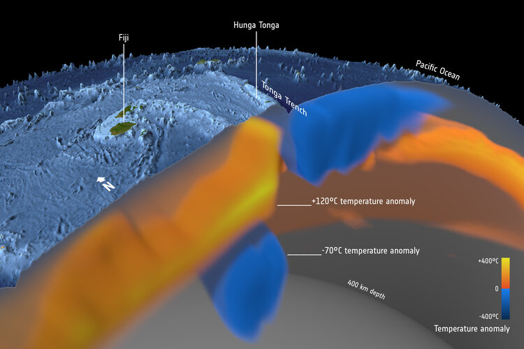
The astonishing force of the Tonga volcanic eruption shocked the world, but the fact that this underwater volcano actually erupted came as less of a surprise to geoscientists using satellite data to study changes in the temperature deep below Earth’s surface.
Zveřejnění obsahu informací poskytnutých na žádost dle zákona č. 106/1999 Sb. za rok 2022
15.2.2022 15:40 ČÚZK - předpisy a opatření Katastrální úřad pro hlavní město Prahuzveřejňuje obsah informace poskytnutých na žádost dle zákona č. 106/1999 Sb. za rok
2022
Zveřejnění obsahu informací poskytnutých na žádost dle zákona č. 106/1999 Sb. za rok 2022
15.2.2022 15:40 ČÚZK /Urady/Katastralni-urady/Katastralni-urady/Katastralni-urad-pro-hlavni-mesto-Prahu/Casto-hledane-informace/Poskytovani-informaci-106-1999-Sb/Zverejneni-obsahu-informaci-poskytnutych-na-za-(1)/Zverejneni-obsahu-informaci-poskytnutych-na-za-(4)Trojice oceněných z katedry na ceně rektora
15.2.2022 15:21 Katedra geoinformatiky UP OlomoucHned tři zástupce naší katedry ocenil rektor UP v rámci akademického týdne při předávání prestižní ceny rektora. Mgr. Tereza Nováková se umístila na druhém místě v kategorii magisterských prací v sekci Vědy o Zemi, vedle finanční odměny si mimo jiné vysloužila i úvodní fotku k této akci na Žurnále 🙂 Čestné uznání rektora autorům odborných knih […]
The post Trojice oceněných z katedry na ceně rektora appeared first on Katedra geoinformatiky.
Patch na Log4j pro ArcGIS Enterprise
15.2.2022 14:34 ARCDATANa konci roku 2021 zahýbala IT světem zranitelnost, která se týká široce používané knihovny Log4j. Společnost Esri záhy vydala sérii mitigačních skriptů, které zredukovaly nebezpečí zneužití této zranitelnosti v produktech ArcGIS. Nejnovější patche pro Portal for ArcGIS 10.8.1 a 10.9.1 jsou zaměřeny právě na její opravu.
Problematikou zranitelnosti Log4j se zabývá průběžně aktualizovaný blog Esri ArcGIS and Apache Log4j Vulnerabilities, na kterém naleznete podrobné informace o výskytu Log4j v různých produktech Esri.
Odkazy na bezpečnostní patche:
Podrobnější informace o obsahu těchto patchů naleznete ve článku ArcGIS Enterprise Log4j Security Patches Available.
Nedostupné školící ISÚI
15.2.2022 12:54 ČÚZK /ruian/Editacni-agendovy-system-ISUI/Provozni-informace-a-odstavky/Archiv-SKOL/Nedostupne-skolici-ISUIRada / odborný rada - organizační pracovník kanceláře ředitele Katastrálního úřadu pro Zlínský kraj
15.2.2022 11:18 ČÚZK - předpisy a opatření Katastrální úřad pro Zlínský kraj kancelář ředitelevypisuje výběrové řízení na místo
Rada / odborný rada - organizační pracovník kanceláře ředitele Katastrálního úřadu pro Zlínský kraj
Rada / odborný rada - organizační pracovník kanceláře ředitele Katastrálního úřadu pro Zlínský kraj
15.2.2022 11:18 ČÚZK /Urady/Katastralni-urady/Katastralni-urady/Katastralni-urad-pro-Zlinsky-kraj/Uredni-deska/Oznameni-a-jina-uredni-sdeleni/Volna-mista/DMS/Rada-odborny-rada-organizacni-pracovnik-kancelRada / odborný rada - organizační pracovník kanceláře ředitele Katastrálního úřadu pro Zlínský kraj
15.2.2022 11:18 ČÚZK - volná místa Katastrální úřad pro Zlínský kraj kancelář ředitele vypisuje výběrové řízení na místo Rada / odborný rada - organizační pracovník kanceláře ředitele Katastrálního úřadu pro Zlínský kraj
Nedostupnosť portálu ESKN
15.2.2022 10:49
ÚGKK SR
V dôsledku poruchy je portál ESKN dočasne nedostupný. Na oprave sa intenzívne pracuje.
Ospravedlňujeme sa Vám za vzniknuté problémy, snažíme sa PORUCHU čo najskôr odstrániť.
Nové číslo GaKO
15.2.2022 10:45
ÚGKK SR
Nové číslo časopisu Geodetického a Kartografického Obzoru 02/2022
20220215- GaKO (2022/2)
15.2.2022 10:43 ČÚZK - aktuality v resortu Aktuální číslo Geodetického a kartografického obzoru (2/2022) je k dispozici ke stažení.20220215- GaKO (2022/2)
15.2.2022 10:43 ČÚZK - předpisy a opatření Český úřad zeměměřický a katastrální zveřejnil novou aktualitu: Aktuální číslo Geodetického a kartografického obzoru (2/2022) je &knbsp;dispozici ke stažení.20220215- GaKO (2022/2)
15.2.2022 10:43 ČÚZK - předpisy a opatření Český úřad zeměměřický a katastrální zveřejnil novou aktualitu: Aktuální číslo Geodetického a kartografického obzoru (2/2022) je k dispozici ke stažení.20220215- GaKO (2022/2)
15.2.2022 10:43 ČÚZK - aktuality v resortu Aktuální číslo Geodetického a kartografického obzoru (2/2022) je k dispozici ke stažení.20220215- GaKO (2022/2)
15.2.2022 10:43 ČÚZK - aktuality v resortu Aktuální číslo Geodetického a kartografického obzoru (2/2022) je k dispozici ke stažení.20220215- GaKO (2022/2)
15.2.2022 10:43 ČÚZK - předpisy a opatření Český úřad zeměměřický a katastrální zveřejnil novou aktualitu: Aktuální číslo Geodetického a kartografického obzoru (2/2022) je k dispozici ke stažení.20220215- GaKO (2022/2)
15.2.2022 10:43 ČÚZK - předpisy a opatření Český úřad zeměměřický a katastrální zveřejnil novou aktualitu: Aktuální číslo Geodetického a kartografického obzoru (2/2022) je k dispozici ke stažení.5 best advantages of flutter app development
15.2.2022 8:43 Siemens Industry SoftwareFlutter is a mobile improvement framework that has become very well known among coders across...
The post 5 best advantages of flutter app development appeared first on Siemens Blog Network.
Satlab Geosolutions Established a Strategic Partnership Alliance with Aplitop
15.2.2022 4:31 Satlab Geosolutions Satlab Geosolutions, a leading surveying equipment manufacturer, has partnered with AplitopSatlab Geosolutions Established a Strategic Partnership Alliance with Aplitop
15.2.2022 4:31 Satlab GeosolutionsSatlab Geosolutions, a leading surveying equipment manufacturer, has partnered with Aplitop
The post Satlab Geosolutions Established a Strategic Partnership Alliance with Aplitop appeared first on Global Satellite Positioning Singapore | SatLab Geosolutions AB.
Satlab Geosolutions Established a Strategic Partnership Alliance with Aplitop
15.2.2022 4:31 Satlab GeosolutionsSatlab Geosolutions, a leading surveying equipment manufacturer, has partnered with Aplitop
The post Satlab Geosolutions Established a Strategic Partnership Alliance with Aplitop appeared first on Global Satellite Positioning Solutions | SatLab Geosolutions AB.
Satlab Geosolutions Established a Strategic Partnership Alliance with Aplitop
15.2.2022 4:31 Satlab Geosolutions Satlab Geosolutions, a leading surveying equipment manufacturer, has partnered with AplitopAPGEO - APG jednala s Radkem Holomčíkem
15.2.2022 1:00 Asociace podnikatelů v geomatice Vedení APG jednalo s náměstkem ministra zemědělství.GaKO 2/2022
14.2.2022 19:56 GaKO GaKO 2/2022 RYPL, O.: Technologie mobilního mapování využívané v pracích studentů českých vysokých školInfrastructure Digital Twins and Future proofing Are Focus at the Year in Infrastructure Conference
14.2.2022 18:58 Bentley SystemsPressCoverage
ARC, USA
Read the articleInfrastructure Digital Twins and Future proofing Are Focus at the Year in Infrastructure Conference
14.2.2022 18:58 Bentley SystemsPressCoverage
ARC Advisory Group, USA
Read the articleGOVSATCOM adds secure governmental communications to the EU Space Programme
14.2.2022 16:38 European GNSS Agency
When disaster strikes, communication, information and location are key. With the addition of GOVSATCOM, the EU Space Programme provides all three.
Last summer, when Greece was ravaged by wildfires, public authorities relied on Copernicus’ Earth Observation services to detect and monitor the evolving situation. On the ground, firefighters and emergency first responders used EGNOS and Galileo to safely guide themselves through the smoke, fog and flames.
That same summer, when once-in-a-century floods in Germany, Belgium, the Netherlands and Luxembourg rendered transportation and communication infrastructure useless, satellite communication, working in synergy with Copernicus and European GNSS (EGNSS), provided rescue teams with the spatial awareness, connectivity and highly accurate positioning and navigation they needed to save lives.
But what happens when an incident occurs where there are no ground stations, either because they were destroyed (e.g., during an earthquake) or because they never existed in the first place (e.g., in remote regions such as the Arctic)? Or what if the end users require secure communication? Such is the case during cyber-attacks and other security-related incidents.
For situations like these, there’s GOVSATCOM.
Adding assured, secure communication to the EU Space Programme’s current capabilities
GOVSATCOM is the fourth pillar of the EU Space Programme. While Copernicus and EGNSS provide the necessary data and positioning, some security incidents also require a means of communication that is robustly protected against interference, interception, intrusion and other risks. GOVSATCOM bridges this gap between the need for assured and secure communication and the capabilities already offered by Copernicus, Galileo and EGNOS.
Once active, GOVSATCOM will provide secure, cost-efficient communication capabilities to security and safety-critical missions, operations and infrastructure. The European Union Agency for the Space Programme (EUSPA) has been entrusted with the procurement of the secure operational ground segment (GOVSATCOM Hubs), its operations and the coordination of the user-related aspects of GOVSATCOM, all in close collaboration with Member States and other involved entities.
As a user-centric programme, GOVSATCOM is designed to meet the unique requirements of governmental applications, including those used for crisis management, surveillance and the management of key infrastructures. Further, to successfully execute their missions, governmental actors must have access to secure satellite communication services, which is something commercial satellite communication services aren’t able to provide.
Keeping EU citizens safe and secure
GOVSATCOM users will likely include border and maritime authorities, law enforcement agencies, civil protection forces, search and rescue services, disaster relief and humanitarian missions, authorised infrastructure operators and military forces. The service will be available to EU institutions, relevant agencies and EU Member States.
GOVSATCOM will also serve specific use cases, such as providing connectivity to the Arctic region and for Machine to Machine (M2M) and Internet of Things (IoT) communications. Furthermore, it will be a central component to the EU’s Secure Connectivity Initiative, which is expected to provide additional EU-owned satellite communications resources to complement existing assets.
With its multiorbital design, Secure Connectivity will allow low latency governmental communications, while its use of quantum technologies will take the security of GOVSATCOM services to the next level. With such capabilities, GOVSATCOM could play an even bigger role in the air traffic control infrastructure that will enable the autonomous and remotely piloted aircraft systems of tomorrow, including drones and air taxis.
Most importantly, by working in synergy with Galileo, EGNOS and Copernicus, GOVSATCOM will further enhance the EU Space Programme’s ability to keep European citizens safe and secure.
Media note: This feature can be republished without charge provided the European Union Agency for the Space Programme (EUSPA) is acknowledged as the source at the top or the bottom of the story. You must request permission before you use any of the photographs on the site. If you republish, we would be grateful if you could link back to the EUSPA website (https://www.euspa.europa.eu).
GOVSATCOM adds secure governmental communications to the EU Space Programme
14.2.2022 16:38 European GNSS Agency
When disaster strikes, communication, information and location are key. With the addition of GOVSATCOM, the EU Space Programme provides all three.
Last summer, when Greece was ravaged by wildfires, public authorities relied on Copernicus’ Earth Observation services to detect and monitor the evolving situation. On the ground, firefighters and emergency first responders used EGNOS and Galileo to safely guide themselves through the smoke, fog and flames.
That same summer, when once-in-a-century floods in Germany, Belgium, the Netherlands and Luxembourg rendered transportation and communication infrastructure useless, satellite communication, working in synergy with Copernicus and European GNSS (EGNSS), provided rescue teams with the spatial awareness, connectivity and highly accurate positioning and navigation they needed to save lives.
But what happens when an incident occurs where there are no ground stations, either because they were destroyed (e.g., during an earthquake) or because they never existed in the first place (e.g., in remote regions such as the Arctic)? Or what if the end users require secure communication? Such is the case during cyber-attacks and other security-related incidents.
For situations like these, there’s GOVSATCOM.
Adding assured, secure communication to the EU Space Programme’s current capabilities
GOVSATCOM is the fourth pillar of the EU Space Programme. While Copernicus and EGNSS provide the necessary data and positioning, some security incidents also require a means of communication that is robustly protected against interference, interception, intrusion and other risks. GOVSATCOM bridges this gap between the need for assured and secure communication and the capabilities already offered by Copernicus, Galileo and EGNOS.
Once active, GOVSATCOM will provide secure, cost-efficient communication capabilities to security and safety-critical missions, operations and infrastructure. The European Union Agency for the Space Programme (EUSPA) has been entrusted with the procurement of the secure operational ground segment (GOVSATCOM Hubs), its operations and the coordination of the user-related aspects of GOVSATCOM, all in close collaboration with Member States and other involved entities.
As a user-centric programme, GOVSATCOM is designed to meet the unique requirements of governmental applications, including those used for crisis management, surveillance and the management of key infrastructures. Further, to successfully execute their missions, governmental actors must have access to secure satellite communication services, which is something commercial satellite communication services aren’t able to provide.
Keeping EU citizens safe and secure
GOVSATCOM users will likely include border and maritime authorities, law enforcement agencies, civil protection forces, search and rescue services, disaster relief and humanitarian missions, authorised infrastructure operators and military forces. The service will be available to EU institutions, relevant agencies and EU Member States.
GOVSATCOM will also serve specific use cases, such as providing connectivity to the Arctic region and for Machine to Machine (M2M) and Internet of Things (IoT) communications. Furthermore, it will be a central component to the EU’s Secure Connectivity Initiative, which is expected to provide additional EU-owned satellite communications resources to complement existing assets.
With its multiorbital design, Secure Connectivity will allow low latency governmental communications, while its use of quantum technologies will take the security of GOVSATCOM services to the next level. With such capabilities, GOVSATCOM could play an even bigger role in the air traffic control infrastructure that will enable the autonomous and remotely piloted aircraft systems of tomorrow, including drones and air taxis.
Most importantly, by working in synergy with Galileo, EGNOS and Copernicus, GOVSATCOM will further enhance the EU Space Programme’s ability to keep European citizens safe and secure.
Media note: This feature can be republished without charge provided the European Union Agency for the Space Programme (EUSPA) is acknowledged as the source at the top or the bottom of the story. You must request permission before you use any of the photographs on the site. If you republish, we would be grateful if you could link back to the EUSPA website (http://www.euspa.europa.eu).
GOVSATCOM adds secure governmental communications to the EU Space Programme
14.2.2022 16:38 European GNSS AgencyWhen disaster strikes, communication, information and location are key. With the addition of GOVSATCOM, the EU Space Programme provides all three.
Last summer, when Greece was ravaged by wildfires, public authorities relied on Copernicus’ Earth Observation services to detect and monitor the evolving situation. On the ground, firefighters and emergency first responders used EGNOS and Galileo to safely guide themselves through the smoke, fog and flames.
That same summer, when once-in-a-century floods in Germany, Belgium, the Netherlands and Luxembourg rendered transportation and communication infrastructure useless, satellite communication, working in synergy with Copernicus and European GNSS (EGNSS), provided rescue teams with the spatial awareness, connectivity and highly accurate positioning and navigation they needed to save lives.
But what happens when an incident occurs where there are no ground stations, either because they were destroyed (e.g., during an earthquake) or because they never existed in the first place (e.g., in remote regions such as the Arctic)? Or what if the end users require secure communication? Such is the case during cyber-attacks and other security-related incidents.
For situations like these, there’s GOVSATCOM.
Adding assured, secure communication to the EU Space Programme’s current capabilities
GOVSATCOM is the fourth pillar of the EU Space Programme. While Copernicus and EGNSS provide the necessary data and positioning, some security incidents also require a means of communication that is robustly protected against interference, interception, intrusion and other risks. GOVSATCOM bridges this gap between the need for assured and secure communication and the capabilities already offered by Copernicus, Galileo and EGNOS.
Once active, GOVSATCOM will provide secure, cost-efficient communication capabilities to security and safety-critical missions, operations and infrastructure. The European Union Agency for the Space Programme (EUSPA) has been entrusted with the procurement of the secure operational ground segment (GOVSATCOM Hubs), its operations and the coordination of the user-related aspects of GOVSATCOM, all in close collaboration with Member States and other involved entities.
As a user-centric programme, GOVSATCOM is designed to meet the unique requirements of governmental applications, including those used for crisis management, surveillance and the management of key infrastructures. Further, to successfully execute their missions, governmental actors must have access to secure satellite communication services, which is something commercial satellite communication services aren’t able to provide.
Keeping EU citizens safe and secure
GOVSATCOM users will likely include border and maritime authorities, law enforcement agencies, civil protection forces, search and rescue services, disaster relief and humanitarian missions, authorised infrastructure operators and military forces. The service will be available to EU institutions, relevant agencies and EU Member States.
GOVSATCOM will also serve specific use cases, such as providing connectivity to the Arctic region and for Machine to Machine (M2M) and Internet of Things (IoT) communications. Furthermore, it will be a central component to the EU’s Secure Connectivity Initiative, which is expected to provide additional EU-owned satellite communications resources to complement existing assets.
With its multiorbital design, Secure Connectivity will allow low latency governmental communications, while its use of quantum technologies will take the security of GOVSATCOM services to the next level. With such capabilities, GOVSATCOM could play an even bigger role in the air traffic control infrastructure that will enable the autonomous and remotely piloted aircraft systems of tomorrow, including drones and air taxis.
Most importantly, by working in synergy with Galileo, EGNOS and Copernicus, GOVSATCOM will further enhance the EU Space Programme’s ability to keep European citizens safe and secure.
Media note: This feature can be republished without charge provided the European Union Agency for the Space Programme (EUSPA) is acknowledged as the source at the top or the bottom of the story. You must request permission before you use any of the photographs on the site. If you republish, we would be grateful if you could link back to the EUSPA website (http://www.euspa.europa.eu).
Satellogic Adds General Joseph F. Dunford Jr., Former Chairman of the Joint Chiefs of Staff, to its Board of Directors, Completes $150 Million Investment by Liberty Strategic Capital and Announces Share Repurchase Program
14.2.2022 16:35 GISCafe.com Webcasts-Webinars General Joseph F. Dunford, Jr. joins Board of Directors that includes Secretary Steven T. Mnuchin and Howard W. LutnickCompletes $150 million …
Ceinsys Tech eyes global expansion; appoints Prashant Kamat as CEO and Vice Chairman of the board to lead foray into the international markets
14.2.2022 16:35 GISCafe.com Webcasts-Webinars NAGPUR, India, Feb. 14, 2022 — (PRNewswire) — Ceinsys Tech Limited (a company listed on Bombay Stock Exchange), which has …Inventing the future of Navigation
14.2.2022 14:30 ESA Navigation Video:
00:05:15
Video:
00:05:15
Many of the experts that designed and oversaw the Galileo satnav system are now supporting cutting-edge European companies in the development of new navigation technologies and services. The result is ESA’s Navigation Innovation and Support Programme, NAVISP.
NAVISP is looking into all kinds of clever ideas about the future of navigation: ways to improve satellite navigation, alternative positioning systems and, new navigation services and applications. Working in partnership with European industry and researchers, more than 200 NAVISP projects have been initiated so far.
NAVISP is divided into three elements, the first looking into improving and expanding satellite navigation, as well as establishing novel ‘positioning, navigation and timing’ (PNT) services. NAVISP’s second element focuses on innovation for competitiveness, developing all kinds of new PNT products and services. Its third element covers support to Member State priorities, including support for national testbeds and programmes.
Autodesk Flex Token – nové možnosti flexibilního licencování
14.2.2022 12:49 Arkance SystemsUšetřete díky flexibilnímu licencování Autodesk Flex Token. Plaťte jen za skutečné využití CAD licencí libovolného produktu.
Zpráva Autodesk Flex Token – nové možnosti flexibilního licencování pochází z arkance-systems.cz.
Nabídka pozice na katedře [Katedra aplikované geoinformatiky a kartografie, byTopic]
14.2.2022 11:30 Katedra aplikované geoinformatiky a kartografie Přf UKNabídka pozice na katedře [Katedra aplikované geoinformatiky a kartografie, byTopic]
14.2.2022 11:30 Katedra aplikované geoinformatiky a kartografie Přf UK Katedra aplikované geoinformatiky a kartografie PřF UK hledá vhodného kandidáta na pozici odborného asistenta se zaměřením na geoinformatiku (GIS, geodatabáze, SDI) nebo kartografii nebo dálkový průzkum ZeměPlánovaná revize údajů KN na období 2022
14.2.2022 11:20 ČÚZK /Urady/Katastralni-urady/Katastralni-urady/Katastralni-urad-pro-Jihomoravsky-kraj/O-uradu/Aktuality/Planovana-revize-udaju-KN-na-obdobi-2022Plánovaná revize údajů KN na období 2022
14.2.2022 11:20 ČÚZK - předpisy a opatření Katastrální úřad pro Jihomoravský kraj zveřejnil novou aktualitu: Plánovaná revize údajů KN na období 2022Plánovaná obnova operátu novým mapováním na období 2022
14.2.2022 10:45 ČÚZK /Urady/Katastralni-urady/Katastralni-urady/Katastralni-urad-pro-Jihomoravsky-kraj/O-uradu/Aktuality/Planovana-obnova-operatu-novym-mapovanim-na-obdobiPlánovaná obnova operátu novým mapováním na období 2022
14.2.2022 10:45 ČÚZK - předpisy a opatření Katastrální úřad pro Jihomoravský kraj zveřejnil novou aktualitu: Plánovaná obnova operátu novým mapováním na období 2022Rozpočet úřadu - rozpis parametrů rozpočtového provizoria na březen 2022
14.2.2022 9:36 ČÚZK /Urady/Zememericke-a-katastralni-inspektoraty/Zememericke-a-katastralni-inspektoraty/Zememericky-a-katastralni-inspektorat-v-Opave/Rozpocet/Rozpocet-uradu-rozpis-parametru-rozpoctoveho-proRozpočet úřadu na rok 2022 po 1. úpravě
14.2.2022 9:36 ČÚZK - předpisy a opatření Zeměměřický a katastrální inspektorát v Opavěvystavuje rozpočet úřadu na březen 2022
2022
Rozpočet úřadu - rozpis parametrů rozpočtového provizoria na březen 2022
14.2.2022 9:36 ČÚZK - předpisy a opatření Zeměměřický a katastrální inspektorát v Opavěvystavuje rozpočet úřadu na březen 2022
2022
Rozpočet úřadu na rok 2022 po 1. úpravě
14.2.2022 9:36 ČÚZK /Urady/Zememericke-a-katastralni-inspektoraty/Zememericke-a-katastralni-inspektoraty/Zememericky-a-katastralni-inspektorat-v-Opave/Rozpocet/Rozpocet-uradu-rozpis-parametru-rozpoctoveho-provrchní referent/rada - rozpočtář-veřejné zakázky Zeměměřického a katastrálního inspektorátu v Opavě
14.2.2022 9:11 ČÚZK - předpisy a opatření Zeměměřický a katastrální inspektorát v OpavěVrchní referent/rada - rozpočtář-veřejné zakázky Zeměměřického a katastrálního inspektorátu v Opavě (obor služby 37., ext. ID 89900010) v oboru služby 37. „Veřejné investování a zadávání veř. zak."
vrchní referent/rada - rozpočtář-veřejné zakázky Zeměměřického a katastrálního inspektorátu v Opavě (obor služby 37., ext. ID 89900010) v oboru služby 37. „Veřejné investování a zadávání veř. zak."
vrchní referent/rada - rozpočtář-veřejné zakázky Zeměměřického a katastrálního inspektorátu v Opavě
14.2.2022 9:11 ČÚZK /Urady/Zememericke-a-katastralni-inspektoraty/Zememericke-a-katastralni-inspektoraty/Zememericky-a-katastralni-inspektorat-v-Opave/Uredni-deska/Oznameni-a-jina-uredni-sdeleni/Volna-mista/vrchni-referent-rada-rozpoctar-verejne-zakazky-Zvrchní referent/rada - rozpočtář-veřejné zakázky Zeměměřického a katastrálního inspektorátu v Opavě
14.2.2022 9:11 ČÚZK - volná místa Zeměměřický a katastrální inspektorát v Opavě vypisuje výběrové řízení na místo vrchní referent/rada - rozpočtář-veřejné zakázky Zeměměřického a katastrálního inspektorátu v OpavěDalší mapové aplikace přeložené do češtiny
14.2.2022 8:53 GISportal.cz
České odborné veřejnosti je známo mnoho aplikací dostupných pod otevřeným kódem. Některé jsou také v češtině. Lokalizovat prostředí pro práci není sice nevyhnutelné, ale usnadňuje přístup i lidem, kteří mapové aplikace používají, ale nejsou profesionály. Počeštění zpříjemňuje učení a zlepšuje orientaci ve složitém rozhraní. U otevřených softwarů je počešťování průběžný, nekončící proces, podle toho, jak […]
The post Další mapové aplikace přeložené do češtiny appeared first on GISportal.cz.
Wordle vs Worldle
13.2.2022 18:05 GISportal.cz
Pokud nežije v úplném internetovém vakuu, tak už jste určitě narazili na hru Wordle – webovou slovní hru, vyvinutou Joshem Wardlem, ve které se hráči snaží uhodnout pětipísmenné slovo v šesti pokusech, a každý den hrají jiné slovo. Hra existuje v různých jazykových mutacích – včetně češtiny. Pokud Vás baví více geografické kvízy, zkuste Worldle […]
The post Wordle vs Worldle appeared first on GISportal.cz.
ISC announcement pitch
12.2.2022 1:31 GISCafe.com Webcasts-Webinars Hexagon Geosystems: ISC West March 23-25 at the Venetian Expo in Las Vegas Booth number 19117
Hexagon Geosystems will exhibit its smart …
USC spatial sciences institute resumes in-person geospatial summit in Los Angeles
12.2.2022 1:03 GISCafe.com Webcasts-Webinars USC Spatial Sciences invites students, young professionals, and industry leaders in the geospatial industry for the opportunity to network and gain …MAPPS Presents the 2021 Geospatial Products and Services Excellence Awards
12.2.2022 0:52 GISCafe.com Webcasts-Webinars Celebrating Innovative Companies Making Impact in Photogrammetric SurveyingWashington, DC (February 2022) – MAPPS, the preeminent association …
Towards an open future Keith Bentley interview
11.2.2022 20:32 Bentley SystemsPressCoverage
AEC Magazine, UK
Read the articleInfrastructure Act Can Drive Digital Twins Says Bentley Systems
11.2.2022 20:17 Bentley SystemsPressCoverage
ENR, USA
Read the articleInfrastructure Act Can Drive Digital Twins Says Bentley Systems
11.2.2022 20:17 Bentley SystemsPressCoverage
ENR, US
Read the articleNew Esri Book Helps Public Safety Agencies Get Started with GIS Technology
11.2.2022 17:07 GISCafe.com Webcasts-Webinars Smart Maps, Dashboards, and Location Data Analysis Have Become Mission-Critical ToolsREDLANDS, Calif. — (BUSINESS WIRE) — February 11, …
NextNav Partners with Critical Response Group to Strengthen Mapping for Emergency Response
11.2.2022 16:16 GISCafe.com Webcasts-Webinars Vertical location will enable awareness and intelligence for mapping of schools, hospitals, public buildingsEWING, N.J., Feb. 11, 2022 — …
Historická ortofotomapa z 50.let se otevírá (TZ)
11.2.2022 15:40 GISportal.cz
Česká informační agentura životního prostředí (CENIA) společně s VGHMÚř Dobruška oznamuje změnu licenčních podmínek pro datovou sadu Historická ortofotomapa (50. léta). Datová sada je nyní dostupná široké veřejnosti pod licencí CC-BY 4.0 (Uveďte původ 4.0 Mezinárodní). Při každém použití těchto dat je tedy nutné uvést licenci CC-BY 4.0, název díla a autory díla v tomto […]
The post Historická ortofotomapa z 50.let se otevírá (TZ) appeared first on GISportal.cz.
The European 112-emergency number to reach new heights thanks to Galileo
11.2.2022 14:07 European GNSS Agency
As of March 17, 2022, all smartphones sold in the European Union should be leveraging Galileo signals, in addition to other Global Navigation Satellite Systems. The addition of the EU positioning system to enhance the 112-calls location will result in faster response times and consequently, more lives saved.
The European 112-emergency number is operational in nearly all EU Member States, as well as other countries. People in danger can call it 24/7 to reach the fire brigade, medical assistance and the police. On February 11, which is European 112 Day, various awareness and networking activities are organised throughout the EU to promote the existence and use of Europe's single emergency number.
The majority of phone calls to the 112-emergency number are placed from mobile phones. These calls already support the sending of location information to emergency services. However, this information was not based on Global Navigation Satellite System (GNSS) capabilities until recently.
Three years ago, the Commission Delegated Regulation anticipated measures to get advantage of GNSS and WiFi location capabilities in smartphones placed on the European Union market from 17 March 2022 onward. This will enable smartphones to transfer caller location information from GNSS (at least Galileo) to the appropriate emergency service.
How does 112 work in Europe?
So far, in the event of a 112 call, the caller’s location information was established through identification technology based on the coverage area of a cellular network tower (cell-ID). The average accuracy of this information varies from two to ten kilometres, which can lead to significant search errors following emergency calls, often resulting in time wasted and potentially, lives lost. In contrast, location information based on GNSS provides an accuracy of down to a few metres. This level of accuracy will have a major impact in terms of response times, ultimately allowing for quicker intervention in emergency situations in which every second counts.
Galileo contributing to saving lives across Europe
The ability for 112 to communicate a caller’s location to emergency services automatically is already being rolled out. The protocol designed for this purpose, called Advanced Mobile Location (AML) is currently being deployed across the European Union. When a caller dials 112 from their smartphone, AML uses the phone’s integrated functionalities and data from Galileo to accurately pinpoint the caller’s location and transmit it to a dedicated end-point, usually a Public Safety Answering Point (PSAP), which makes the caller location available to emergency responders in real-time.
According to the European Emergency Number Association (EENA), at least 18 EU Member States have already completed the AML deployment while others are in the process of doing so. This implementation is thanks to EU initiatives and projects such as the Help 112 project, which was set up to evaluate the merits of handset-based technologies in improving the location of emergency callers..
“On the occasion of European 112 Day, I would like to reiterate once again that the EU Space Programme and in this particular case, Galileo, were conceived to benefit and protect EU citizens. The EC regulation which shall enter into force late next month is another confirmation of the added value EU space data brings to our daily lives,’’ said EUSPA Executive Director, Rodrigo da Costa. ‘’On this day, let’s also praise our real-life heroes, emergency responders, across the EU for their courage and bravery,’’ he concluded.
The European 112-emergency number to reach new heights thanks to Galileo
11.2.2022 14:07 European GNSS AgencyAs of 17 March 2022, all smartphones placed in the European single market should be leveraging Galileo signals, in addition to other Global Navigation Satellite Systems. The addition of the EU positioning system to enhance the 112-calls location will result in faster response times and consequently, more lives saved.
The European 112-emergency number is operational in nearly all EU Member States, as well as other countries. People in danger can call it 24/7 to reach the fire brigade, medical assistance and the police. On February 11, which is European 112 Day, various awareness and networking activities are organised throughout the EU to promote the existence and use of Europe's single emergency number.
The majority of phone calls to the 112-emergency number are placed from mobile phones. These calls already support the sending of location information to emergency services. However, this information was not based on Global Navigation Satellite System (GNSS) capabilities until recently.
Three years ago, the Commission Delegated Regulation anticipated measures to get advantage of GNSS and WiFi location capabilities in smartphones placed on the European Union market from 17 March 2022 onward. This will enable smartphones to transfer caller location information from GNSS (at least Galileo) to the appropriate emergency service.
How does 112 work in Europe?
So far, in the event of a 112 call, the caller’s location information was established through identification technology based on the coverage area of a cellular network tower (cell-ID). The average accuracy of this information varies from two to ten kilometres, which can lead to significant search errors following emergency calls, often resulting in time wasted and potentially, lives lost. In contrast, location information based on GNSS provides an accuracy of down to a few metres. This level of accuracy will have a major impact in terms of response times, ultimately allowing for quicker intervention in emergency situations in which every second counts.
Galileo contributing to saving lives across Europe
The ability for 112 to communicate a caller’s location to emergency services automatically is already being rolled out. The protocol designed for this purpose, called Advanced Mobile Location (AML) is currently being deployed across the European Union. When a caller dials 112 from their smartphone, AML uses the phone’s integrated functionalities and data from Galileo to accurately pinpoint the caller’s location and transmit it to a dedicated end-point, usually a Public Safety Answering Point (PSAP), which makes the caller location available to emergency responders in real-time.
According to the European Emergency Number Association (EENA), at least 18 EU Member States have already completed the AML deployment while others are in the process of doing so. This implementation is thanks to EU initiatives and projects such as the Help 112 project, which was set up to evaluate the merits of handset-based technologies in improving the location of emergency callers..
“On the occasion of European 112 Day, I would like to reiterate once again that the EU Space Programme and in this particular case, Galileo, were conceived to benefit and protect EU citizens. The EC regulation which shall enter into force late next month is another confirmation of the added value EU space data brings to our daily lives,’’ said EUSPA Executive Director, Rodrigo da Costa. ‘’On this day, let’s also praise our real-life heroes, emergency responders, across the EU for their courage and bravery,’’ he concluded.
The European 112-emergency number to reach new heights thanks to Galileo
11.2.2022 14:07 European GNSS AgencyAs of March 17, 2022, all smartphones sold in the European Union should be leveraging Galileo signals, in addition to other Global Navigation Satellite Systems. The addition of the EU positioning system to enhance the 112-calls location will result in faster response times and consequently, more lives saved.
The European 112-emergency number is operational in nearly all EU Member States, as well as other countries. People in danger can call it 24/7 to reach the fire brigade, medical assistance and the police. On February 11, which is European 112 Day, various awareness and networking activities are organised throughout the EU to promote the existence and use of Europe's single emergency number.
The majority of phone calls to the 112-emergency number are placed from mobile phones. These calls already support the sending of location information to emergency services. However, this information was not based on Global Navigation Satellite System (GNSS) capabilities until recently.
Three years ago, the Commission Delegated Regulation anticipated measures to get advantage of GNSS and WiFi location capabilities in smartphones placed on the European Union market from 17 March 2022 onward. This will enable smartphones to transfer caller location information from GNSS (at least Galileo) to the appropriate emergency service.
How does 112 work in Europe?
So far, in the event of a 112 call, the caller’s location information was established through identification technology based on the coverage area of a cellular network tower (cell-ID). The average accuracy of this information varies from two to ten kilometres, which can lead to significant search errors following emergency calls, often resulting in time wasted and potentially, lives lost. In contrast, location information based on GNSS provides an accuracy of down to a few metres. This level of accuracy will have a major impact in terms of response times, ultimately allowing for quicker intervention in emergency situations in which every second counts.
Galileo contributing to saving lives across Europe
The ability for 112 to communicate a caller’s location to emergency services automatically is already being rolled out. The protocol designed for this purpose, called Advanced Mobile Location (AML) is currently being deployed across the European Union. When a caller dials 112 from their smartphone, AML uses the phone’s integrated functionalities and data from Galileo to accurately pinpoint the caller’s location and transmit it to a dedicated end-point, usually a Public Safety Answering Point (PSAP), which makes the caller location available to emergency responders in real-time.
According to the European Emergency Number Association (EENA), at least 18 EU Member States have already completed the AML deployment while others are in the process of doing so. This implementation is thanks to EU initiatives and projects such as the Help 112 project, which was set up to evaluate the merits of handset-based technologies in improving the location of emergency callers..
“On the occasion of European 112 Day, I would like to reiterate once again that the EU Space Programme and in this particular case, Galileo, were conceived to benefit and protect EU citizens. The EC regulation which shall enter into force late next month is another confirmation of the added value EU space data brings to our daily lives,’’ said EUSPA Executive Director, Rodrigo da Costa. ‘’On this day, let’s also praise our real-life heroes, emergency responders, across the EU for their courage and bravery,’’ he concluded.
As of 17 March 2022, all smartphones placed in the European Single Market should be leveraging Galileo signals
11.2.2022 14:07 European GNSS AgencyAs of 17 March 2022, all smartphones placed in the European single market should be leveraging Galileo signals, in addition to other Global Navigation Satellite Systems. The addition of the EU positioning system to enhance the 112-calls location will result in faster response times and consequently, more lives saved.
The European 112-emergency number is operational in nearly all EU Member States, as well as other countries. People in danger can call it 24/7 to reach the fire brigade, medical assistance and the police.
The majority of phone calls to the 112-emergency number are placed from mobile phones. These calls already support the sending of location information to emergency services. However, this information was not based on Global Navigation Satellite System (GNSS) capabilities until recently.
Three years ago, the Commission Delegated Regulation anticipated measures to get advantage of GNSS and WiFi location capabilities in smartphones placed on the European Union market from 17 March 2022 onward. This will enable smartphones to transfer caller location information from GNSS (at least Galileo) to the appropriate emergency service.
How does 112 work in Europe?
So far, in the event of a 112 call, the caller’s location information was established through identification technology based on the coverage area of a cellular network tower (cell-ID). The average accuracy of this information varies from two to ten kilometres, which can lead to significant search errors following emergency calls, often resulting in time wasted and potentially, lives lost. In contrast, location information based on GNSS provides an accuracy of down to a few metres. This level of accuracy will have a major impact in terms of response times, ultimately allowing for quicker intervention in emergency situations in which every second counts.
Galileo contributing to saving lives across Europe
The ability for 112 to communicate a caller’s location to emergency services automatically is already being rolled out. The protocol designed for this purpose, called Advanced Mobile Location (AML) is currently being deployed across the European Union. When a caller dials 112 from their smartphone, AML uses the phone’s integrated functionalities and data from Galileo to accurately pinpoint the caller’s location and transmit it to a dedicated end-point, usually a Public Safety Answering Point (PSAP), which makes the caller location available to emergency responders in real-time.
According to the European Emergency Number Association (EENA), at least 18 EU Member States have already completed the AML deployment while others are in the process of doing so. This implementation is thanks to EU initiatives and projects such as the Help 112 project, which was set up to evaluate the merits of handset-based technologies in improving the location of emergency callers..
“On the occasion of European 112 Day, I would like to reiterate once again that the EU Space Programme and in this particular case, Galileo, were conceived to benefit and protect EU citizens. The EC regulation which enters into force today is another confirmation of the added value EU space data brings to our daily lives,’’ said EUSPA Executive Director, Rodrigo da Costa. ‘’On this day, let’s also praise our real-life heroes, emergency responders, across the EU for their courage and bravery,’’ he concluded.
4 Key features of mobile app development
11.2.2022 12:26 Siemens Industry SoftwareThese days, everybody is having a cell phone. Mobile users are expanding step by step...
The post 4 Key features of mobile app development appeared first on Siemens Blog Network.
Earth from Space: Hereford, Texas
11.2.2022 10:00 ESA Observing the Earth
Hereford, and its surrounding colourful patchwork of agricultural fields, is featured in this Copernicus Sentinel-2 image.
Applanix Introduces Next-Generation OEM Solution for Mobile Mapping Applications Using GNSS-Inertial Technology
11.2.2022 9:00 GISCafe.com Webcasts-Webinars Applanix Introduces Next-Generation OEM Solution for Mobile Mapping Applications Using GNSS-Inertial TechnologyHardware and Software Platform …