


zprávy
zdroje zpráv:Rozhovor se studentem GÚ Lukášem Jiráskem
14.2.2020 0:00 Geografický ústav MUPřečtěte si rozhovor se studentem Lukášem Jiráskem o svých zkušenostech během studia na Geografickém ústavu PřF MU - Masarykova univerzita mě hodně zaujala de facto vším – přístupem ke studentům, prezentací sebe sama, odborností a kvalitou
Nabídka stipendií ve Francii pro PhD studenty
14.2.2020 0:00 Geografický ústav MUNabídku stipendií v česko-francouzském programu mobility pro PhD studenty naleznete na webu https://www.sci.muni.cz/student/vyveska-pro-studenty/nabidka-stipendii-v-cesko-francouzskem-programu-mobility-pro-phd-studenty.
Nabídka stipendií ve Francii pro PhD studenty
14.2.2020 0:00 Geografický ústav MUNabídku stipendií v česko-francouzském programu mobility pro PhD studenty naleznete na webu https://www.sci.muni.cz/student/vyveska-pro-studenty/nabidka-stipendii-v-cesko-francouzskem-programu-mobility-pro-phd-studenty
Stipendia na letní kurzy a studijní/výzkumné pobyty pro studenty a učitele VŠ
14.2.2020 0:00 Geografický ústav MULetní školy:
Lotyšsko nabízí studentům a učitelům VŠ 2 místa na tematicky a oborově zaměřené letní školy. Tematická škála je široka: bryologie, robotika, 3D animace, inženýrství (Smart Cities), dějiny umění, cestovní ruch a lotyšský jazyk. Seznam letních škol naleznete zde. Zájemci zasílají přihlášky do 14. února do kanceláře AIA. Stipendium ve výše 711 Eur se vyplácí přímo organizátorům letní školy.
Termín odevzdání přihlášek na letní kurzy v Albánii a na letní kurz bulharského jazyka a na zimní seminář balkanistiky na univerzitě v Blagoevgradu v Bulharsko se prodloužil do 6. března 2020. Přihlášky se posílá do sídla Akademické informační agentury. Stipendium zahrnuje bezplatnou účast na letní škole, ubytování a stravování.
Zájemci o letní kurzy estonského jazyka a kultury a jiné kurzy v angličtině konané na univerzitách v Estonsku podávají přihlášky přímo estonské vzdělávací agentuře Archimedes Foundation do 19. března. Českou stranu o podání žádosti pouze informují. Různé letní školy v AJ nabízí Tallinn Univerzity, Tallinn University of Technology, University of Tartu a Estonian Academy of Arts. Seznam letních škol naleznete zde. Stipendium zahrnuje až 500 Eur na poplatek za kurz a 25 Eur denně na ubytování po maximálním trvání 28 dní.
Česko-bavorská vysokoškolská agentura nabízí stipendia na letní a zimní jazykové a tematické zaměřené školy v Bavorsku. Seznam kurzů naleznete zde. Přihlášky přijímá sídlo BTHA v Řeznu do 1. dubna. Stipendium zahrnuje poplatek za kurz, případně také příspěvek na ubytování ve výše 400 Eur.
Studijní a výzkumné pobyty:
Slovenskonabízí 10 stipendijních míst na studijní pobyty pro studenty MSP a DSP. Zájemci podávají přihlášky v termínu do 21. února do kanceláře AIA. Stipendium pro studenty BSP a MSP činí 280 Eur, pro studenty DSP 330 Eur a pro VŠ učitele 550 Eur/měsíčně.
Studenti a pedagogové VŠ mohoudo 27. února odevzdávat přihlášky na studijní či výzkumné pobyty v Polsku v délce od 1 do 10 měsíců. Stipendium pro studenty BSP a MSP činí 9000 Kč, pro studenty DSP a VŠ učitele 9500 Kč/měsíčně.
Deadliny pro podání žádost o stipendium na studijní či výzkumné pobyty v Albánie, Bulharsku, Gruzii a Rumunsku se prodloužily do 6. března 2020.
Výše stipendia do Albánie je pro studenty BSP/MSP 6500 Kč, pro studenty DSP 6700 a pro VŠ učitele 7000 Kč.
Výše stipendia do Bulharska je pro studenty BSP/MSP 6500 Kč, pro studenty DSP a 6700 Kč.
Na akademický rok 2019/2020 činilo stipendium do Gruzie 800 GEL/měsíčně.
Výše stipendia do Rumunska je pro studenty BSP/MSP 7700 Kč, pro studenty DSP 8000 Kč a pro VŠ učitele 8500 Kč/měsíčně.
Tchaj-wan nabízí dva druhy stipendia:
- Víceletá stipendia ke studiu v BSP, MSP a DSP a na jazykové kurzy mandarínské čínštiny v délce od 3 do 12 měsíců.
Výše stipendia: bakalářské studium a jazykový kurs čínštiny 15 000 tchajwanských dolarů (přibližně 500 amerických dolarů) měsíčně, magisterské nebo doktorandské studium 20 000 tchajwanských dolarů (přibližně 655 amerických dolarů) měsíčně. Za studenty bude také uhrazeno školné (případně i některé další poplatky související se studiem) až do maximální výše 40 000 tchajwanských dolarů za semestr. - Huayu Enrichment Scholarship Program: Stipendia na jednoroční případně devítiměsíční, šestiměsíční nebo tříměsíční jazykový kurs (mandarinské) čínštiny.
Výše stipendia: 25 000 tchajwanských dolarů (přibližně 800 amerických dolarů) měsíčně.
Žádosti se podávají na Tchajpejskou hospodářskou a kulturní kancelář v Praze, a to v době od 29. ledna do 31. března 2020.
OGC considering CityJSON as community standard; seeks public comment for new Work Item
13.2.2020 21:41 GISCafe.com Webcasts-Webinars Contact: info@opengeospatial.org 13 February 2020: The Open Geospatial Consortium (OGC) is considering CityJSON for adoption as an official …
1Spatial forms strategic partnership with Neueda
13.2.2020 19:48 GISCafe.com Webcasts-Webinars February 13, 2020 -- Cambridge, UK, (www.1spatial.com) 1Spatial has formed a strategic partnership …Forestry Commission Uses Aerial Photography to Create Forest & Woodland Maps
13.2.2020 19:47 GISCafe.com Webcasts-Webinars The UK’s Forestry Commission has revealed how it is using the latest aerial photography to manage and regulate public and private forests in …Trimble Announces Record 2019 Financial Results
13.2.2020 19:46 GISCafe.com Webcasts-Webinars - Record annual revenue, net income, operating cash flowSUNNYVALE, Calif., Feb. 12, 2020 — (PRNewswire) — Trimble Inc. (NASDAQ: …
Fortem Technologies Showcases Revolutionary SkyDome System at Industry Day on the Hill
13.2.2020 19:46 GISCafe.com Webcasts-Webinars System uses AI to create safe airspace for venues like University of Utah hospital and urban corridorsPLEASANT GROVE, Utah, Feb. 12, 2020 — …
Trimble Announces Call for Speakers for its 2020 Dimensions User Conference
13.2.2020 19:46 GISCafe.com Webcasts-Webinars SUNNYVALE, Calif., Feb. 13, 2020 — (PRNewswire) — Trimble (NASDAQ: TRMB) has opened its Call for Speakers for the 2020 Trimble …Zveřejnění obsahu informací poskytnutých na žádost dle zákona č. 106/1999 Sb. za rok 20
13.2.2020 14:45 ČÚZK /Urady/Katastralni-urady/Katastralni-urady/Katastralni-urad-pro-Stredocesky-kraj/Casto-hledane-informace/Poskytovani-informaci-106-1999-Sb/Zverejneni-obsahu-informaci-poskytnutych-na-za-(1)/Zverejneni-obsahu-informaci-poskytnutych-na-za-(2)Zveřejnění obsahu informací poskytnutých na žádost dle zákona č. 106/1999 Sb. za rok 20
13.2.2020 14:45 ČÚZK - předpisy a opatření Katastrální úřad pro Středočeský krajzveřejňuje obsah informace poskytnutých na žádost dle zákona č. 106/1999 Sb. za rok 2020
2020
Exkurze studentů SPŠ zeměměřická
13.2.2020 14:14 Hrdlička Začátkem února jsme u nás ve společnosti přivítali studenty 3. a 4. ročníků..HRDLIČKA spol. s r.o. - Exkurze studentů SPŠ zeměměřická
13.2.2020 14:14 Hrdlička Začátkem února jsme u nás ve společnosti přivítali studenty 3. a 4. ročníků..rada/odborný rada – organizační pracovník
13.2.2020 14:13 ČÚZK - volná místa Katastrální úřad pro hlavní město Prahu kancelář ředitele vypisuje výběrové řízení na místo rada/odborný rada – organizační pracovníkrada/odborný rada – organizační pracovník Katastrálního úřadu pro hlavní město Prahu, Kancelář ředit
13.2.2020 14:13 ČÚZK - předpisy a opatření Katastrální úřad pro hlavní město Prahuvypisuje výběrové řízení na místo
rada/odborný rada – organizační pracovník Katastrálního úřadu pro hlavní město Prahu, Kancelář ředitele úřadu
rada/odborný rada – organizační pracovník
13.2.2020 14:13 ČÚZK - předpisy a opatření Katastrální úřad pro hlavní město Prahuvypisuje výběrové řízení na místo
rada/odborný rada – organizační pracovník
rada/odborný rada – organizační pracovník
13.2.2020 14:13 ČÚZK /Urady/Katastralni-urady/Katastralni-urady/Katastralni-urad-pro-hlavni-mesto-Prahu/Uredni-deska/Oznameni-a-jina-uredni-sdeleni/Volna-mista/DMS/rada-odborny-rada-–-organizacni-pracovnikrada/odborný rada – organizační pracovník Katastrálního úřadu pro hlavní město Prahu, Kancelář ředit
13.2.2020 14:13 ČÚZK /Urady/Katastralni-urady/Katastralni-urady/Katastralni-urad-pro-hlavni-mesto-Prahu/Uredni-deska/Oznameni-a-jina-uredni-sdeleni/Volna-mista/DMS/rada-odborny-rada-–-organizacni-pracovnikrada/odborný rada – organizační pracovník Katastrálního úřadu pro hlavní město Prahu, Kancelář ředit
13.2.2020 14:13 ČÚZK - volná místa Katastrální úřad pro hlavní město Prahu vypisuje výběrové řízení na místo rada/odborný rada – organizační pracovník Katastrálního úřadu pro hlavní město Prahu, Kancelář ředitrada/odborný rada – organizační pracovník
13.2.2020 14:13 ČÚZK - předpisy a opatření Katastrální úřad pro hlavní město Prahu kancelář ředitelevypisuje výběrové řízení na místo
rada/odborný rada – organizační pracovník
rada/odborný rada – organizační pracovník
13.2.2020 14:13 ČÚZK - volná místa Katastrální úřad pro hlavní město Prahu vypisuje výběrové řízení na místo rada/odborný rada – organizační pracovník20200213 - Souhrné přehledy o půdním fondu
13.2.2020 13:06 ČÚZK - předpisy a opatření Český úřad zeměměřický a katastrální zveřejnil novou aktualitu: Zveřejněna publikace "Souhrnné přehledy o půdním fondu z údajů katastru nemovitostí České republiky 2020".20200231
13.2.2020 13:06 ČÚZK - předpisy a opatření Český úřad zeměměřický a katastrální zveřejnil novou aktualitu: Zveřejněna publikace "Souhrnné přehledy o půdním fondu z údajů katastru nemovitostí České republiky 2020".OGC Announces Publication of Open Routing API Pilot Results
13.2.2020 12:22 GISCafe.com Webcasts-Webinars New OGC Engineering Reports document outcomes of the Open Routing API Pilot, including new capabilities to easily share routes and prototype APIs …Jakub byl v GSA jako člen advisory board na finále H2020 projektu SARA na využití dronů v Search and Rescue
13.2.2020 10:54 UpVisionVčera byl Jakub v GSA jako člen advisory board na finálním workshopu H2020 projektu SARA na využití dronů v Search and Rescue, který vedou naši italští přátelé. Včera byl Jakub v GSA jako člen advisory board na finálním workshopu H2020 projektu SARA na využití dronů v Search and Rescue, který vedou naši italští přátelé. 🙂 Zveřejnil(a) UpVision dne Středa 12. února […]
The post Jakub byl v GSA jako člen advisory board na finále H2020 projektu SARA na využití dronů v Search and Rescue appeared first on Upvision.
EEA varuje mapami před změnou klimatu
13.2.2020 9:30 ARCDATAEvropská agentura pro životní prostředí (EEA) vytvořila sérii map Climate change impacts in Europe, v nichž čtenářům přibližuje scénáře, které v Evropě mohou do konce 21. století nastat. Vedle zvýšení hladiny oceánů, a tím pádem zaplavení přímořských oblastí, bude největším problémem sucho a nedostatek vody.
Na portálu iDnes.cz si můžete o těchto závěrech přečíst článek, který upozorňuje na kritickou situaci a varuje před dopady klimatické změny. Na tento problém dlouhodobě upozorňují také odborníci z Ústavu výzkumu globální změny AV ČR v.v.i., CzechGlobe. V článku tak můžete najít i zasvěcené komentáře Pavla Zahradníčka z tohoto pracoviště.
EEA na situaci upozorňuje již několik let, tentokrát se snaží oslovit odbornou i širokou veřejnost prostřednictvím mapové aplikace Climate change impacts in Europe, která byla vytvořena v novém prostředí pro tvorbu webových aplikací ArcGIS Experience Builder.

Výroční zpráva dle zákona č. 106/1999 Sb. za rok 2019
13.2.2020 9:29 ČÚZK - předpisy a opatření Český úřad zeměměřický a katastrálnívydává výroční zprávu úřadu za rok
2019
Výroční souhrnná resortní zpráva za rok 2019
13.2.2020 9:29 ČÚZK - předpisy a opatření Český úřad zeměměřický a katastrálnívydává výroční zprávu úřadu za rok
2019
Únorový Missing Maps mapathon v Praze (pozvánka)
13.2.2020 8:54 GISportal.cz
Únorový Missing Maps mapathon v Praze se bude konat v sídle KPMG 25. února od 18 do 21. Přihlásit se můžete zde. Přijďte a podpořte práci humanitárních organizací tím, že pomůžete zmapovat místa, která jsou nejvíce ohrožena krizemi. Mapathon společně organizují Lékaři bez hranic a dobrovolníci z české komunity Missing Maps. Co se na setkání bude dít? Na Mapathonu […]
The post Únorový Missing Maps mapathon v Praze (pozvánka) appeared first on GISportal.cz.
Leica Tour: Co letos uvidíte?
13.2.2020 6:02 ZeměměřičBlíží se letošní Leica Tour, na které jsou vždy představovány technologické novinky Leica Geosystems. Zeptali jsme se Filipa Kobrleho z firmy GEFOS na podrobnosti. Na Leica Tour vždy představujete novinky. Jaké to budou letos? Letos máme pro návštěvníky Leica Tour samozřejmě opět připravenu řadu novinek. Budeme prezentovat nový ruční laserový skener BLK2Go, inovovanou multistanici a další inovativní […]
The post Leica Tour: Co letos uvidíte? appeared first on Zeměměřič.
Katastrální mapy 1:2 880 evidenční – Morava a Slezsko
13.2.2020 1:00 Cenia - Katalog metadat ČR - INSPIRE Podle právní úpravy z roku 1883 musely být katastrální operáty vyhotovené podle výsledků jednorázové reambulace stabilního katastru udržovány v přesném souladu se skutečným a právním stavem. Platnost originálních map stabilního katastru, využívaných do té doby jako mapy evidenční, byla postupně ukončována. Evidence byla dále prováděna na jednom z jejich otisků, považovaném za novou platnou katastrální mapu. Zákon ukládal držitelům, soudům a jiným úřadům ohlašovací povinnost, to znamená, že každá změna musela být ihned oznámena bernímu nebo katastrálnímu měřickému úřadu, který zajistil její zaměření. Jeho výsledky, které jsou uchovány v dokumentacích příslušných katastrálních úřadů, byly podkladem pro údržbu katastrálních map, která spočívala v přeškrtání neplatného stavu a v doplnění stavu nového, vše červeně. Po ukončení platnosti katastrálních map, formálně vyjádřené zápisem: K reprodukci připraveno podle stavu ke dni 31.12.1..., následovala nová obnova reprodukcí, ke které nedocházelo v pravidelných intervalech, ale podle potřeby.Lokality výskytu národně významných druhů
13.2.2020 1:00 Cenia - Katalog metadat ČR - INSPIRE Lokality národně významných druhů převzaté z monitoringu ohrožených druhů, zajišťovaného Agenturou ochrany přírody a krajiny ČR; vrstva obsahuje jednoduché prvky (Singlepart Features); © AOPK ČR, 2020VZ: Komplexní pozemkové úpravy v Jižních Čechách (nadlimit. 12 mil. Kč)
12.2.2020 21:37 ZeměměřičZáměrem předmětné nadlimitní veřejné zakázky na služby dělené na části je v části 1. veřejné zakázky zpracování kompletního návrhu komplexních pozemkových úprav v katastrálním území Dobročkov, včetně všech geodetických prací, a to v třídě přesnosti 3, určené pro obnovu katastrálního operátu a tvorby DKM a v části 2. veřejné zakázky zpracování kompletního návrhu komplexních pozemkových úprav v katastrálním území Želnava, včetně všech geodetických prací, a to […]
The post VZ: Komplexní pozemkové úpravy v Jižních Čechách (nadlimit. 12 mil. Kč) appeared first on Zeměměřič.
L3Harris Technologies Selected by US Air Force for Artificial Intelligence Contract
12.2.2020 21:16 GISCafe.com Webcasts-Webinars L3Harris Technologies Selected by US Air Force for Artificial Intelligence ContractHighlights:
Fills critical gap for training data needed for …
Teledyne CARIS’ HIPS and SIPS 11.3 release introduces revolutionary AI approach to cleaning sonar noise
12.2.2020 21:14 GISCafe.com Webcasts-Webinars Fredericton, NB, Canada, February 11, 2020 — Teledyne CARIS, a Teledyne Technologies [NYSE:TDY] company, is pleased to announce the release of …Earth from space: Bolivian highland heart
12.2.2020 17:44 ESA Observing the Earth Video:
00:00:00
Video:
00:00:00
For Valentine's Day, this week's edition of the Earth from Space programme features a Copernicus Sentinel-2 image, capturing a beautiful heart-shaped geographical formation in the dramatic landscape of the southern highlands of Bolivia.
See also Bolivian highland heart to download the image.
Erasmus+ [Katedra aplikované geoinformatiky a kartografie, byTopic]
12.2.2020 17:30 Katedra aplikované geoinformatiky a kartografie Přf UK Katedra aplikované geoinformatiky a kartografie uzavřela pro školní rok 2020/2021 bilaterální smlouvy s dvanácti institucemi.20200212-VŘ Řízení kvality
12.2.2020 16:11 ČÚZK - předpisy a opatření Český úřad zeměměřický a katastrální zveřejnil novou aktualitu: Oznámení o vyhlášení výběrového řízení na obsazení služebního místa Řízení kvality.Řízení kvality
12.2.2020 15:50 ČÚZK - předpisy a opatření Český úřad zeměměřický a katastrálnívypisuje výběrové řízení na místo
Řízení kvality
Řízení kvality
12.2.2020 15:50 ČÚZK - volná místa Český úřad zeměměřický a katastrální vypisuje výběrové řízení na místo Řízení kvalityŘízení kvality
12.2.2020 15:50 ČÚZK /Urady/Cesky-urad-zememericky-a-katastralni/Uredni-deska/Oznameni-a-jina-uredni-sdeleni/Volna-mista/DMS/Rizeni-kvalityJuniper Systems Limited Launches Mesa 3 Rugged Tablet Now Running Android
12.2.2020 14:52 GISCafe.com Webcasts-Webinars BIRMINGHAM, United Kingdom, Feb. 12, 2020 (GLOBE NEWSWIRE) -- Today Juniper Systems Limited, a manufacturer of rugged computers, announced the …Konference GIS Ostrava je vhodná i pro geodety
12.2.2020 14:24 ZeměměřičKatedra geoinformatiky VŠB-TU Ostrava zve na tradiční symposium GIS Ostrava 2020, v rámci něhož se konají konference „Prostorová data pro Smart City a Smart Region“ a „UAV in Smart City and Smart Region“ společně s řadou seminářů. Sympozium je organizováno v termínu 18. – 20. března 2020. Jako klíčoví řečníci se představí Francesco Nex (University of Twente) s tématem „New trends of […]
The post Konference GIS Ostrava je vhodná i pro geodety appeared first on Zeměměřič.
Iceberg shattered
12.2.2020 14:10 ESA Observing the Earth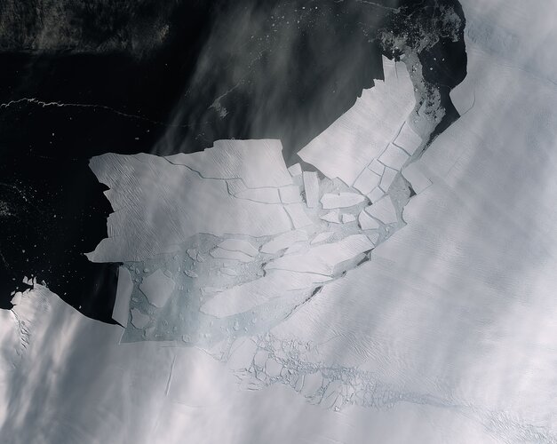 Image:
The Pine Island Glacier recently spawned an iceberg over 300 sq km that very quickly shattered into pieces. This almost cloud-free image, captured on 11 February by the Copernicus Sentinel-2 mission, shows the freshly broken bergs in detail.
A recent animation using 57 radar images captured by the Copernicus Sentinel-1 mission shows just how quickly the emerging cracks from the glacier grew – leading to this historic calving event.
Thanks to the combination of both optical and radar images from the Copernicus Sentinel satellite missions, growing cracks were spotted in the Pine Island Glacier last year, and since then, scientists have been keeping a close eye on how quick the cracks were growing.
The Pine Island Glacier, along with its neighbour Thwaites glacier, connect the centre of the West Antarctic Ice Sheet with the ocean, and together discharge significant quantities of ice into the ocean.
Iceberg shattered
12.2.2020 14:10 ESA Observing the Earth
Image:
The Pine Island Glacier recently spawned an iceberg over 300 sq km that very quickly shattered into pieces. This almost cloud-free image, captured on 11 February by the Copernicus Sentinel-2 mission, shows the freshly broken bergs in detail.
A recent animation using 57 radar images captured by the Copernicus Sentinel-1 mission shows just how quickly the emerging cracks from the glacier grew – leading to this historic calving event.
Thanks to the combination of both optical and radar images from the Copernicus Sentinel satellite missions, growing cracks were spotted in the Pine Island Glacier last year, and since then, scientists have been keeping a close eye on how quick the cracks were growing.
The Pine Island Glacier, along with its neighbour Thwaites glacier, connect the centre of the West Antarctic Ice Sheet with the ocean, and together discharge significant quantities of ice into the ocean.
Europe and US look to future of positioning
12.2.2020 13:42 ESA Navigation
ESA’s NAVISP programme is helping invent the future of positioning, navigation and timing beyond current satellite navigation technology. The Agency’s NAVISP Industry Days welcomed a guest speaker from the US government, sharing details of a parallel effort she is overseeing from the other side of the Atlantic.
New version of 3D streaming community standard, I3S, adopted and published by OGC
12.2.2020 10:15 GISCafe.com Webcasts-Webinars Latest version of the I3S Community Standard, used for streaming large 3D datasets to desktop and mobile devices, adds Point Cloud Scene Layer type, …Cyklokoncepce pro období 2017 - 2023
12.2.2020 10:00 Středočeský kraj Do mapové aplikace Cyklokoncepce pro období 2017 – 2023 byla přidána nová vrstva Styčné body s Prahou. Tyto body zobrazují aktuální stav přípravy opatření ke vzniku chráněné trasy na hranici Středočeského kraje s Prahou. Data připravil a pravidelně aktualizuje Odbor dopravy.Spaceflight Industries Signs Definitive Agreement to Sell Spaceflight, its Rideshare Launch Services Provider, to Japan’s Mitsui & Co., Ltd and Yamasa Co., Ltd.
12.2.2020 9:25 GISCafe.com Webcasts-Webinars Subject to regulatory clearance, Spaceflight becomes the cornerstone of Mitsui & Co.’s space strategy, continuing to operate as an …Pozvánka na odborný workshop Indoor Cartography
12.2.2020 8:25 Česká kartografická společnost Masarykova univerzita ve spolupráci s komisemi Mezinárodní kartografické asociace (International Cartographic Association): Commission on User Experience (commission chair: R. Roth), Commission on Cognitive Issues in Geographic Information Visualization (commission chair: A. Griffin) a Commission on Location-Based Services (commission chair: H. Huang) zvou na společný workshop na téma Indoor Cartography, který bude součástí mezioborové konference KOGNICE A UMĚLÝ ŽIVOT 2020, […]Mapa roku 2019
12.2.2020 8:16 GISportal.cz
Česká kartografická společnost pořádá již 22. ročník prestižní kartografické soutěže Mapa roku. Uzávěrka přihlášek je 28. 2. 2020. Pokud jste tedy vytvořili zajímavý kartografický produkt, neváhejte svoji mapu do soutěže přihlásit! Soutěží se v těchto kategoriích: Atlasy, soubory a edice map Samostatná kartografická díla Kartografická díla pro školy a vzdělávání Studentské kartografické práce Digitální kartografické […]
The post Mapa roku 2019 appeared first on GISportal.cz.
Mapa roku 2020
12.2.2020 8:16 GISportal.czČeská kartografická společnost pořádá již 22. ročník prestižní kartografické soutěže Mapa roku. Uzávěrka přihlášek je 28. 2. 2020. Pokud jste tedy vytvořili zajímavý kartografický produkt, neváhejte svoji mapu do soutěže přihlásit! Soutěží se v těchto kategoriích: Atlasy, soubory a edice map Samostatná kartografická díla Kartografická díla pro školy a vzdělávání Studentské kartografické práce Digitální kartografické […]
The post Mapa roku 2020 appeared first on GISportal.cz.
EUROCARTO 2020
12.2.2020 7:00 Česká asociace pro geoinformace EUROCARTO 2020V termínu 20. - 22. 9. 2020 se uskuteční ve Vídni prestižní středoevropská kartografická konference EuroCarto 2020 ! Do 15. 3. 2020 můžete hlásit své příspěvky. Podrobnější informace naleznete na https://eurocarto2020.org/home/
Přehled všech témat:
Art and cartography
Map Design, Usability and Cognition
GeoVisual Analytics and Multivariate Big Data
Fortem Technologies Secures Non-ITAR Classification for International Trade of Key Products and Solutions
12.2.2020 3:53 GISCafe.com Webcasts-Webinars PLEASANT GROVE, Utah, Feb. 11, 2020 — (PRNewswire) — Fortem Technologies, Inc., the market leader of C-UAS security and defense …Esri Federal GIS Conference Spotlights Government Organizations Creating a Sustainable Future
12.2.2020 3:53 GISCafe.com Webcasts-Webinars Annual Event Showcases Federal Government Using GIS for Evidence-Based Decision-MakingREDLANDS, Calif. — (BUSINESS WIRE) — …
InventHelp Inventor Develops Electronic Aerial Package Delivery System (KXX-211)
12.2.2020 3:53 GISCafe.com Webcasts-Webinars PITTSBURGH, Feb. 11, 2020 — (PRNewswire) — While online and mail order package delivery systems have proven beneficial, variables …Nabídka studijních pobytů - Polsko, Lotyšsko, Slovensko
12.2.2020 0:00 Geografický ústav MUDovolujeme si Vás informovat o vypsání dodatečného výběrového řízení na obsazení 9 stipendijních míst na letním jazykovém kurzu v Polsku. Termín odevzdání přihlášek je 12. února 2020 do 15 hodin.
Polsko dále nabízí stipendia ke studijním a výzkumným pobytům: nyní zůstává nevyužito cca 100 stipendijních měsíců studijních a výzkumných pobytů pro studenty BSP, MSP a DSP a 27 stipendijních měsíců studijních a výzkumných pobytů pro akademické pracovníky. Termín odevzdání přihlášek na tyto druhy pobytů je 27. února 2020 do 15 hodin.
Lotyšsko nabízí studentům BSP, MSP a DSP a VŠ učitelům 2 místa na tematicky a oborově zaměřených letních školách. Výuka probíhá v angličtině. Nabídka aktuálních letních škol bývá zveřejněna na přelomu ledna a února na stránkách lotyšské Státní agentury pro rozvoj vzdělávání. Termín odevzdání přihlášek je 14. února 2020 do 12:00.
Slovensko poskytuje stipendia na studijní pobyty pro studenty MSP a DSP. Celkem je k dispozici 10 stipendijních míst. Termín odevzdání přihlášek je 21. února 2020.
Podrobné informace o nabízených stipendiích a podmínkách pro uchazeče o pobyty v uvedených zemích naleznete v našem webovém vyhledávači. Zájemci doručí požadované dokumenty ve stanoveném termínudo sídla Akademické informační agentury (Dům zahraniční spolupráce, AIA, Na Poříčí 1035/4, 110 00 Praha 1).
Do výběrových řízení se mohou hlásit studenti, resp. vyučující veřejných VŠ. Obecné informace k výběrovým řízením naleznete zde.
Nabídka studijních pobytů - Polsko, Lotyšsko, Slovensko
12.2.2020 0:00 Geografický ústav MUDovolujeme si Vás informovat o vypsání dodatečného výběrového řízení na obsazení 9 stipendijních míst na letním jazykovém kurzu v Polsku. Termín odevzdání přihlášek je 12. února 2020 do 15 hodin.
Polsko dále nabízí stipendia ke studijním a výzkumným pobytům: nyní zůstává nevyužito cca 100 stipendijních měsíců studijních a výzkumných pobytů pro studenty BSP, MSP a DSP a 27 stipendijních měsíců studijních a výzkumných pobytů pro akademické pracovníky. Termín odevzdání přihlášek na tyto druhy pobytů je 27. února 2020 do 15 hodin.
Lotyšsko nabízí studentům BSP, MSP a DSP a VŠ učitelům 2 místa na tematicky a oborově zaměřených letních školách. Výuka probíhá v angličtině. Nabídka aktuálních letních škol bývá zveřejněna na přelomu ledna a února na stránkách lotyšské Státní agentury pro rozvoj vzdělávání. Termín odevzdání přihlášek je 14. února 2020 do 12:00.
Slovensko poskytuje stipendia na studijní pobyty pro studenty MSP a DSP. Celkem je k dispozici 10 stipendijních míst. Termín odevzdání přihlášek je 21. února 2020.
Podrobné informace o nabízených stipendiích a podmínkách pro uchazeče o pobyty v uvedených zemích naleznete v našem webovém vyhledávači. Zájemci doručí požadované dokumenty ve stanoveném termínudo sídla Akademické informační agentury (Dům zahraniční spolupráce, AIA, Na Poříčí 1035/4, 110 00 Praha 1).
Do výběrových řízení se mohou hlásit studenti, resp. vyučující veřejných VŠ. Obecné informace k výběrovým řízením naleznete zde.
Esri Partners with Saint Louis University to Advance Geospatial Research and Innovation
11.2.2020 18:13 GISCafe.com Webcasts-Webinars Partnership Will Focus on Projects for Emergency Management, Health Care, Public Safety, and Economic DevelopmentREDLANDS, Calif. — (BUSINESS …
SkyGrid Adds Hyper-Local Weather Data for Safer Drone Operations
11.2.2020 15:14 GISCafe.com Webcasts-Webinars New partnership with data provider ClimaCell enhances the company's aerial operating system with micro-weather feeds for hyper-accurate, on-demand …North Dakota Signs Participating Addendum with Avion Unmanned to Provide Drone Services to Public Agencies
11.2.2020 15:14 GISCafe.com Webcasts-Webinars HUNTSVILLE, Ala., Feb. 11, 2020 — (PRNewswire) — Avion Unmanned, the Unmanned Aircraft Systems (UAS) division of Avion Solutions, …Epson Introduces Two New Large-format Document Scanners Designed to Exceed the Needs of High-Volume Businesses
11.2.2020 15:13 GISCafe.com Webcasts-Webinars New DS-32000 and DS-30000 Flexible, Fast and Reliable Desktop Document ScannersLONG BEACH, Calif., Feb. 11, 2020 — (PRNewswire) — …
CoreLogic Reports U.S. Overall Delinquency Rate Lowest for a November in at Least 20 Years
11.2.2020 15:13 GISCafe.com Webcasts-Webinars No states posted an annual gain in overall delinquency rate in NovemberNorth Carolina and the District of Columbia posted the largest annual …
New mobile app from Rezatec helping Latin American farmers increase crop yields by 12%
11.2.2020 15:11 GISCafe.com Webcasts-Webinars Harwell, Oxfordshire, UK, 11 February 2020 – Rezatec, a leading provider of geospatial data analytics, has launched a free smartphone app which …20200211 - VŘ - KP Tachov
11.2.2020 13:14 ČÚZK - předpisy a opatření Český úřad zeměměřický a katastrální zveřejnil novou aktualitu: Oznámení o vyhlášení výběrového řízení na obsazení služebního místa ředitele katastrálního pracoviště Tachov.Středoevropská kartografická konference EuroCarto 2020 (pozvánka)
11.2.2020 13:13 GISportal.cz
V termínu 20. – 22. září se ve Vídni uskuteční 68. německý kartografický kongres a zároveň středoevropská kartografická konference EuroCarto 2020. Příspěvky v angličtině či němčině v rozsahu 800 slov lze zasílat do 15. dubna. Témata konference jsou mimo jiné: Art and cartography Map Design, Usability and Cognition GeoVisual Analytics and Multivariate Big Data Mapping […]
The post Středoevropská kartografická konference EuroCarto 2020 (pozvánka) appeared first on GISportal.cz.
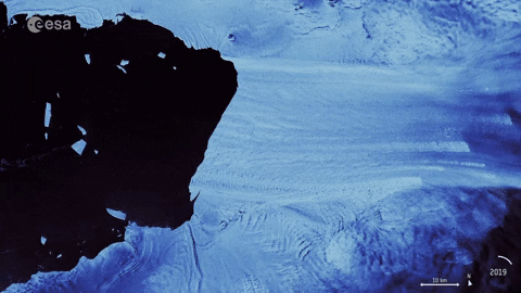
Pine Island Glacier spawns piglets
11.2.2020 10:27 ESA Observing the Earth Video:
00:00:11
Video:
00:00:11
As anticipated, Pine Island Glacier, known as PIG for short, in Antarctica has just spawned a huge iceberg. At over 300 sq km, about the size of Malta, this huge berg very quickly broke into many ‘piglet’ pieces the largest of which is dubbed B-49. Thanks to images from the Copernicus Sentinel satellite missions, two large rifts in the glacier were spotted last year and scientists have been keeping a close eye on how quickly these cracks were growing. This animation uses 57 radar images captured by the Copernicus Sentinel-1 mission between February 2019 and February 2020 (the last frame is from 10 February 2020) and shows just how quickly the emerging cracks grew and led to this calving event.
Pine Island Glacier, along with its neighbour Thwaites Glacier, connect the centre of the West Antarctic Ice Sheet with the ocean – together discharging significant quantities of ice into the ocean. These two glaciers have been losing ice over the last 25 years. Owing to their extremely remote location, satellites play a critical role in measuring and monitoring Antarctic glaciology – revealing the timing and pace of glacial retreat in Antarctica. Since the early 1990s, the Pine Island Glacier’s ice velocity has increased dramatically to values which exceed 10 m a day. Its floating ice front, which has an average thickness of approximately 500 metres, has experienced a series of calving events over the past 30 years, some of which have abruptly changed the shape and position of the ice front.
These changes have been mapped by ESA-built satellites since the 1990s, with calving events occurring in 1992, 1995, 2001, 2007, 2013, 2015, 2017, 2018, and now 2020.
Mark Drinkwater, senior scientist and cryosphere specialist remarked, “The Copernicus twin Sentinel-1 all-weather satellites have established a porthole through which the public can watch events like this unfold in remote regions around the world. What is unsettling is that the daily data stream reveals the dramatic pace at which climate is redefining the face of Antarctica.”
Pine Island Glacier spawns piglets
11.2.2020 10:27 ESA Observing the Earth
Video:
00:00:11
As anticipated, Pine Island Glacier, known as PIG for short, in Antarctica has just spawned a huge iceberg. At over 300 sq km, about the size of Malta, this huge berg very quickly broke into many ‘piglet’ pieces the largest of which is dubbed B-49. Thanks to images from the Copernicus Sentinel satellite missions, two large rifts in the glacier were spotted last year and scientists have been keeping a close eye on how quickly these cracks were growing. This animation uses 57 radar images captured by the Copernicus Sentinel-1 mission between February 2019 and February 2020 (the last frame is from 10 February 2020) and shows just how quickly the emerging cracks grew and led to this calving event.
Pine Island Glacier, along with its neighbour Thwaites Glacier, connect the centre of the West Antarctic Ice Sheet with the ocean – together discharging significant quantities of ice into the ocean. These two glaciers have been losing ice over the last 25 years. Owing to their extremely remote location, satellites play a critical role in measuring and monitoring Antarctic glaciology – revealing the timing and pace of glacial retreat in Antarctica. Since the early 1990s, the Pine Island Glacier’s ice velocity has increased dramatically to values which exceed 10 m a day. Its floating ice front, which has an average thickness of approximately 500 metres, has experienced a series of calving events over the past 30 years, some of which have abruptly changed the shape and position of the ice front.
These changes have been mapped by ESA-built satellites since the 1990s, with calving events occurring in 1992, 1995, 2001, 2007, 2013, 2015, 2017, 2018, and now 2020.
Mark Drinkwater, senior scientist and cryosphere specialist remarked, “The Copernicus twin Sentinel-1 all-weather satellites have established a porthole through which the public can watch events like this unfold in remote regions around the world. What is unsettling is that the daily data stream reveals the dramatic pace at which climate is redefining the face of Antarctica.”
Get the animated gif here.
The Copernicus Sentinel-2 image can be found here.
Pine Island Glacier spawns piglets
11.2.2020 10:27 ESA Observing the Earth
Video:
00:00:11
As anticipated, Pine Island Glacier, known as PIG for short, in Antarctica has just spawned a huge iceberg. At over 300 sq km, about the size of Malta, this huge berg very quickly broke into many ‘piglet’ pieces the largest of which is dubbed B-49. Thanks to images from the Copernicus Sentinel satellite missions, two large rifts in the glacier were spotted last year and scientists have been keeping a close eye on how quickly these cracks were growing. This animation uses 57 radar images captured by the Copernicus Sentinel-1 mission between February 2019 and February 2020 (the last frame is from 10 February 2020) and shows just how quickly the emerging cracks grew and led to this calving event.
Pine Island Glacier, along with its neighbour Thwaites Glacier, connect the centre of the West Antarctic Ice Sheet with the ocean – together discharging significant quantities of ice into the ocean. These two glaciers have been losing ice over the last 25 years. Owing to their extremely remote location, satellites play a critical role in measuring and monitoring Antarctic glaciology – revealing the timing and pace of glacial retreat in Antarctica. Since the early 1990s, the Pine Island Glacier’s ice velocity has increased dramatically to values which exceed 10 m a day. Its floating ice front, which has an average thickness of approximately 500 metres, has experienced a series of calving events over the past 30 years, some of which have abruptly changed the shape and position of the ice front.
These changes have been mapped by ESA-built satellites since the 1990s, with calving events occurring in 1992, 1995, 2001, 2007, 2013, 2015, 2017, 2018, and now 2020.
Mark Drinkwater, senior scientist and cryosphere specialist remarked, “The Copernicus twin Sentinel-1 all-weather satellites have established a porthole through which the public can watch events like this unfold in remote regions around the world. What is unsettling is that the daily data stream reveals the dramatic pace at which climate is redefining the face of Antarctica.”
Get the animated gif here.
Pine Island Glacier spawns piglets
11.2.2020 10:27 ESA Observing the Earth
Video:
00:00:11
As anticipated, Pine Island Glacier, known as PIG for short, in Antarctica has just spawned a huge iceberg. At over 300 sq km, about the size of Malta, this huge berg very quickly broke into many ‘piglet’ pieces the largest of which is dubbed B-49. Thanks to images the Copernicus Sentinel satellite missions, two large rifts in the glacier were spotted last year and scientists have been keeping a close eye on how quickly these cracks were growing. This animation uses 57 radar images captured by the Copernicus Sentinel-1 mission between February 2019 and February 2020 (the last frame is from today, 11 February 2020) and shows just how quickly the emerging cracks grew and led to this calving event.
Pine Island Glacier, along with its neighbour Thwaites Glacier, connect the centre of the West Antarctic Ice Sheet with the ocean – together discharging significant quantities of ice into the ocean. These two glaciers have been losing ice over the last 25 years. Owing to their extremely remote location, satellites play a critical role in measuring and monitoring Antarctic glaciology – revealing the timing and pace of glacial retreat in Antarctica. Since the early 1990s, the Pine Island Glacier’s ice velocity has increased dramatically to values which exceed 10 m a day. Its floating ice front, which has an average thickness of approximately 500 metres, has experienced a series of calving events over the past 30 years, some of which have abruptly changed the shape and position of the ice front.
These changes have been mapped by ESA-built satellites since the 1990s, with calving events occurring in 1992, 1995, 2001, 2007, 2011, 2013, 2015, 2017, 2018, and now 2020.
Mark Drinkwater, senior scientist and cryosphere specialist remarked, “The Copernicus twin Sentinel-1 all-weather satellites have established a porthole through which the public can watch events like this unfold in remote regions around the world. What is unsettling is that the daily data stream reveals the dramatic pace at which climate is redefining the face of Antarctica.”
Pine Island Glacier spawns piglets
11.2.2020 10:27 ESA Observing the Earth
Video:
00:00:11
As anticipated, Pine Island Glacier, known as PIG for short, in Antarctica has just spawned a huge iceberg. At over 300 sq km, about the size of Malta, this huge berg very quickly broke into many ‘piglet’ pieces the largest of which is dubbed B-49. Thanks to images from the Copernicus Sentinel satellite missions, two large rifts in the glacier were spotted last year and scientists have been keeping a close eye on how quickly these cracks were growing. This animation uses 57 radar images captured by the Copernicus Sentinel-1 mission between February 2019 and February 2020 (the last frame is from 10 February 2020) and shows just how quickly the emerging cracks grew and led to this calving event.
Pine Island Glacier, along with its neighbour Thwaites Glacier, connect the centre of the West Antarctic Ice Sheet with the ocean – together discharging significant quantities of ice into the ocean. These two glaciers have been losing ice over the last 25 years. Owing to their extremely remote location, satellites play a critical role in measuring and monitoring Antarctic glaciology – revealing the timing and pace of glacial retreat in Antarctica. Since the early 1990s, the Pine Island Glacier’s ice velocity has increased dramatically to values which exceed 10 m a day. Its floating ice front, which has an average thickness of approximately 500 metres, has experienced a series of calving events over the past 30 years, some of which have abruptly changed the shape and position of the ice front.
These changes have been mapped by ESA-built satellites since the 1990s, with calving events occurring in 1992, 1995, 2001, 2007, 2011, 2013, 2015, 2017, 2018, and now 2020.
Mark Drinkwater, senior scientist and cryosphere specialist remarked, “The Copernicus twin Sentinel-1 all-weather satellites have established a porthole through which the public can watch events like this unfold in remote regions around the world. What is unsettling is that the daily data stream reveals the dramatic pace at which climate is redefining the face of Antarctica.”
Pine Island Glacier spawns piglets
11.2.2020 10:27 ESA Observing the Earth
Video:
00:00:11
As anticipated, Pine Island Glacier, known as PIG for short, in Antarctica has just spawned a huge iceberg. At over 300 sq km, about the size of Malta, this huge berg very quickly broke into many ‘piglet’ pieces the largest of which is dubbed B-49. Thanks to images from the Copernicus Sentinel satellite missions, two large rifts in the glacier were spotted last year and scientists have been keeping a close eye on how quickly these cracks were growing. This animation uses 57 radar images captured by the Copernicus Sentinel-1 mission between February 2019 and February 2020 (the last frame is from today, 11 February 2020) and shows just how quickly the emerging cracks grew and led to this calving event.
Pine Island Glacier, along with its neighbour Thwaites Glacier, connect the centre of the West Antarctic Ice Sheet with the ocean – together discharging significant quantities of ice into the ocean. These two glaciers have been losing ice over the last 25 years. Owing to their extremely remote location, satellites play a critical role in measuring and monitoring Antarctic glaciology – revealing the timing and pace of glacial retreat in Antarctica. Since the early 1990s, the Pine Island Glacier’s ice velocity has increased dramatically to values which exceed 10 m a day. Its floating ice front, which has an average thickness of approximately 500 metres, has experienced a series of calving events over the past 30 years, some of which have abruptly changed the shape and position of the ice front.
These changes have been mapped by ESA-built satellites since the 1990s, with calving events occurring in 1992, 1995, 2001, 2007, 2011, 2013, 2015, 2017, 2018, and now 2020.
Mark Drinkwater, senior scientist and cryosphere specialist remarked, “The Copernicus twin Sentinel-1 all-weather satellites have established a porthole through which the public can watch events like this unfold in remote regions around the world. What is unsettling is that the daily data stream reveals the dramatic pace at which climate is redefining the face of Antarctica.”
Pozvánka na soutěžní studentskou konferenci GISáček 2020
11.2.2020 9:50 Blogující geomatici - FAV ZČU Konference GISáček je určená studentům vysokých škol, kteří zde mají možnost prezentovat výsledky svých odborných studentských prací. Stejně jako v předchozích letech bude konference součástí Sympozia GIS Ostrava 2020, které bude probíhat ve dnech 18.3.-20.3.2020. Všichni aktivní účastnici se mohou zdarma tohoto sympozia zúčastnit.Konečná uzavírka abstraktů: 5.3.2020.
Více informací naleznete na http://gisak.vsb.cz/gisostrava/cz/gisacek.php.
SBG Systems strengthens its presence in Asia.
11.2.2020 9:00 GISCafe.com Webcasts-Webinars Carrières-sur-Seine, France, February 10th, 2019 - SBG Systems to announce the opening of its new subsidiary in Singapore. Located in the …Solar Orbiter reaches for our star
11.2.2020 9:00 GISCafe.com Webcasts-Webinars @AirbusSpace @esascience @ESASolarOrbiter #SolarOrbiterStevenage/Cape Canaveral, Florida, 10 February 2020 - The Airbus built Sun …
20200211 Rada / odborný rada oddělení právních vztahů k nemovitostem
11.2.2020 8:54 ČÚZK /Urady/Katastralni-urady/Katastralni-urady/Katastralni-urad-pro-Stredocesky-kraj/Katastralni-pracoviste/KP-Melnik/O-uradu/Aktuality/20190828-Odborny-rada-oddeleni-pravnich-vztahu-(3)20200211 Rada / odborný rada oddělení právních vztahů k nemovitostem
11.2.2020 8:54 ČÚZK - předpisy a opatření Katastrální úřad pro Středočeský kraj - Katastrální pracoviště Mělník Vyhlášení výběrového řízení: Rada / odborný rada oddělení právních vztahů k nemovitostem V části "Úřední deska", v sekci "Oznámení a jiná úřední sdělení" bylo vystaveno "Oznámení o vyhlášení výběrového řízení na obsazení služebního místa Rada / odborný rada oddělení právních vztahů k nemovitostem"Rada / odborný rada oddělení právních vztahů k nemovitostem
11.2.2020 8:47 ČÚZK /Urady/Katastralni-urady/Katastralni-urady/Katastralni-urad-pro-Stredocesky-kraj/Uredni-deska/Oznameni-a-jina-uredni-sdeleni/Volna-mista/Rada-odborny-rada-oddeleni-pravnich-vztahu-k-n-(1)Rada / odborný rada oddělení právních vztahů k nemovitostem
11.2.2020 8:47 ČÚZK - předpisy a opatření Katastrální úřad pro Středočeský kraj - Katastrální pracoviště Mělníkvypisuje výběrové řízení na místo Rada / odborný rada oddělení právních vztahů k nemovitostem
Rada / odborný rada oddělení právních vztahů k nemovitostem
Rada / odborný rada oddělení právních vztahů k nemovitostem
11.2.2020 8:47 ČÚZK - volná místa Katastrální úřad pro Středočeský kraj - Katastrální pracoviště Mělník vypisuje výběrové řízení na místo Rada / odborný rada oddělení právních vztahů k nemovitostemSdělení - uzavření Katastrálního pracoviště Most
11.2.2020 8:11 ČÚZK - předpisy a opatření Katastrální úřad pro Ústecký kraj - Katastrální pracoviště Mostzveřejnil novou aktualitu: Z důvodu opravy havárie na vodovodním zařízení bude dne 11. února 2020 Katastrální pracoviště Most uzavřeno.
Sdělení - uzavření Katastrálního pracoviště Most
11.2.2020 8:11 ČÚZK /Urady/Katastralni-urady/Katastralni-urady/Katastralni-urad-pro-Ustecky-kraj/Katastralni-pracoviste/KP-Most/O-uradu/Aktuality/Sdeleni-uzavreni-Katastralniho-pracoviste-MostPodrobný program 55. GID v Brně. Podívejte se
11.2.2020 7:00 ZeměměřičZačátkem března se v Brně uskuteční dvoudenní geodetické informační dny. Akci 55. GID pořádá Spolek zeměměřičů Brno. Program v úterý 3. března 2020 Ing. Karel Večeře (předseda, Český úřad zeměměřický a katastrální): Dění v resortu ČÚZK v roce 2019 Ing. Michal Leitman (ředitel katastrálneho odboru, Úrad geodézie, kartografie a katastra SR): Informace z resortu ÚGKK SR Ing. Petr Souček, Ph.D. (Český úřad zeměměřický […]
The post Podrobný program 55. GID v Brně. Podívejte se appeared first on Zeměměřič.
Maloplošná zvláště chráněná území
11.2.2020 1:00 Cenia - Katalog metadat ČR - INSPIRE Hranice vyhlášených maloplošných zvláště chráněných území (národní přírodní rezervace, národní přírodní památky, přírodní rezervace, přírodní památky) a jejich ochranných pásem; vrstva obsahuje složené prvky (Multipart Features); © AOPK ČR, 2020ATOM INSPIRE Protected sites
11.2.2020 1:00 Cenia - Katalog metadat ČR - INSPIRE The download service provides spatial data for all protected sites according to the theme No. 9 mentioned in Annex I of the INSPIRE Directive (2007/2/EC) that are gathered by Nature Conservation Agency of the Czech Republic. Namely the service displays Natura 2000 sites, IUCN protected areas, UNESCO biosphere reserves, ramsar sites and other nationally protected areas (buffer zones of specially protected areas, contract protected areas); © NCA CR (AOPK ČR), 2013 - 2020INSPIRE Protected sites
11.2.2020 1:00 Cenia - Katalog metadat ČR - INSPIRE This data set contains spatial data for all protected sites according to the theme No. 9 mentioned in Annex I of the INSPIRE Directive (2007/2/EC) that are gathered by Nature Conservation Agency of the Czech Republic. Namely the data set consists of Natura 2000 sites, IUCN protected areas, UNESCO biosphere reserves, ramsar sites and other nationally protected areas (buffer zones of specially protected areas, contract protected areas); © NCA CR (AOPK ČR), 2013 - 2020VÚV TGM - ATOM - INSPIRE
11.2.2020 1:00 Cenia - Katalog metadat ČR - INSPIRE Stahovací služba ATOM pro přístup k předpřipraveným prioritním datovým sadám oblasti voda podle směrnice INSPIRE. Mezi prioritní jsou zařazeny ty datové sady, které byly reportovány Evropské komisi na základě některé z dalších evropských směrnic.WMS INSPIRE Protected sites
11.2.2020 1:00 Cenia - Katalog metadat ČR - INSPIRE This view service shows spatial data for all protected sites according to the theme No. 9 mentioned in Annex I of the INSPIRE Directive (2007/2/EC) that are gathered by Nature Conservation Agency of the Czech Republic. Namely the service displays Natura 2000 sites, IUCN protected areas, UNESCO biosphere reserves, ramsar sites and other nationally protected areas (buffer zones of specially protected areas, contract protected areas); © NCA CR (AOPK ČR), 2013 - 2020Ochranná pásma MZCHÚ ze zákona
11.2.2020 1:00 Cenia - Katalog metadat ČR - INSPIRE Hranice ochranných pásem maloplošných zvláště chráněných území ze zákona; vrstva obsahuje složené prvky (Multipart Features); © AOPK ČR, 2020Harmonogram státních závěrečných zkoušek - únor 2020
11.2.2020 0:00 Geografický ústav MUHarmonogram SZZ pro únor 2020 je ke stažení ZDE.
Zveřejnění obsahu informací poskytnutých na žádost dle zákona č. 106/1999 Sb. za rok 2020
10.2.2020 16:16 ČÚZK /Urady/Katastralni-urady/Katastralni-urady/Katastralni-urad-pro-Jihocesky-kraj/Casto-hledane-informace/Poskytovani-informaci-106-1999-Sb/Zverejneni-obsahu-informaci-poskytnutych-na-za-(1)/Zverejneni-obsahu-informaci-poskytnutych-na-za-(2)Zveřejnění obsahu informací poskytnutých na žádost dle zákona č. 106/1999 Sb. za rok 2020
10.2.2020 16:16 ČÚZK - předpisy a opatření Katastrální úřad pro Jihočeský krajzveřejňuje obsah informace poskytnutých na žádost dle zákona č. 106/1999 Sb. za rok
2020
"GISCafe Industry Predictions 2020 – Part 6 "by Susan Smith
10.2.2020 15:49 GISCafe.com Webcasts-WebinarsMMC's drones used in the battle against the new coronavirus outbreak
10.2.2020 15:49 GISCafe.com Webcasts-Webinars BEIJING, Feb. 9, 2020 — (PRNewswire) — The beginning of 2020 is special to most Chinese - with a sudden coronavirus outbreak firstly …Woolpert Awarded Esri Release Ready Specialty Partner Status
10.2.2020 15:49 GISCafe.com Webcasts-Webinars The credential confirms Woolpert's ability to implement and support the latest Esri software solutions.DAYTON, Ohio, Feb. 10, 2020 — …
Rada / odborný rada – vedoucí oddělení právních vztahů k nemovitostem katastru nemovitostí Katastrál
10.2.2020 14:30 ČÚZK /Urady/Katastralni-urady/Katastralni-urady/Katastralni-urad-pro-Kralovehradecky-kraj/Uredni-deska/Oznameni-a-jina-uredni-sdeleni/Volna-mista/Rada-odborny-rada-–-vedouci-oddeleni-pravnich-vzRada / odborný rada – vedoucí oddělení právních vztahů k nemovitostem katastru nemovitostí Katastrál
10.2.2020 14:30 ČÚZK - volná místa Katastrální úřad pro Královéhradecký kraj - Katastrální pracoviště Hradec Králové vypisuje výběrové řízení na místo Rada / odborný rada – vedoucí oddělení právních vztahů k nemovitostem katastru nemovitostí KatastrálRada / odborný rada – vedoucí oddělení právních vztahů k nemovitostem katastru nemovitostí Katastrál
10.2.2020 14:30 ČÚZK - předpisy a opatření Katastrální úřad pro Královéhradecký kraj - Katastrální pracoviště Hradec Královévypisuje výběrové řízení na místo
Rada / odborný rada – vedoucí oddělení právních vztahů k nemovitostem katastru nemovitostí Katastrálního pracoviště Hradec Králové
Podpora Windows 7 skončila
10.2.2020 12:38 GEPROSpolečnost Microsoft k datu 14. ledna 2020 ukončila podporu klientského operačního systému Windows 7.… >>
VZ: Komplexní pozemkové úpravy Orličky
10.2.2020 10:36 ZeměměřičStátní pozemkový úřad vypsal nadlimitní veřejnou zakázku na komplexní pozemkové úpravy. Předmětem plnění nadlimitní veřejné zakázky na služby je zpracování návrhu komplexních pozemkových úprav (dále jen „KoPÚ“) Orličky, včetně nezbytných geodetických prací v třídě přesnosti určené pro obnovu katastru nemovitostí vyhláškou č. 357/2013 Sb. Návrh KoPÚ bude zpracován tak, aby jej bylo možno zapsat do katastru nemovitostí. […]
The post VZ: Komplexní pozemkové úpravy Orličky appeared first on Zeměměřič.
ČÚZK – krátkodobé přerušení provozu DP a WSDP
10.2.2020 10:12 GEPROČÚZK plánuje přerušit provoz Dálkového přístupu (DP) a Webových služeb dálkového přístupu (WSDP) ve čtvrtek 13.… >>
Začínáme se Solid Edge: Modelování závlačky
10.2.2020 9:57 Konstruktér V tomto postupu si ukážeme, jak vymodelovat standardizovanou pružnou závlačku, která se používá pro zajištění [...]ČÚZK ve čtvrtek 13.2.2020 od 1
10.2.2020 9:53 GEUSware ČÚZK ve čtvrtek 13.2.2020 od 16:30 do 18:30 zcela přeruší provoz Dálkového přístupu (DP) i Webových služeb dálkového přístupu (WSDP). Z tohoto důvodu budou v GEUSu nefunkční Podklady měření a Odesílání GP.Výběrové řízení v novém programu BE&ST - BE and STudy Abroad
10.2.2020 9:13 Blogující geomatici - FAV ZČU BE&ST - BE and STudy Abroad program, ve kterém studenti bakalářských studijních programů mohou získat prostředky až 200.000 Kč na semestrální pobyt na jedné ze dvou partnerských univerzitách v USA (Millikin U., Southern Utah U.). Deadline přihlášek je 29.2.2020. Více info na http://international.zcu.cz/ostatni/best.htmlDeadline přihlášek na mobility Free-movers 2020 a Erasmus+ 2020/21
10.2.2020 9:11 Blogující geomatici - FAV ZČU Deadline je ve středu 12.2.2020 a studenti se letos nově hlásí výhradně přes portál. Všechny informace mají studenti na obvyklém místě:https://www.fav.zcu.cz/mobility
Výběrové řízení na služební místo ředitel katastrálního pracoviště – RKP15
10.2.2020 9:01 ČÚZK /Urady/Katastralni-urady/Katastralni-urady/Katastralni-urad-pro-Plzensky-kraj/O-uradu/Aktuality/Vyberove-rizeni-na-sluzebni-misto-reditel-katastraVýběrové řízení na služební místo ředitel katastrálního pracoviště – RKP15
10.2.2020 9:01 ČÚZK - předpisy a opatření Katastrální úřad pro Plzeňský kraj - Katastrální pracoviště Tachov zveřejnil novou aktualitu: Oznámení o vyhlášení výběrového řízení na služební místo <a href="/Aktuality/2-ozn-o-vyhl-vyberoveho-rizeni-TC.aspx">Ředitel katastrálního pracoviště – RKP15, Katastrální úřad pro Plzeňský kraj, Katastrální pracoviště Tachov</a>Výběrové řízení na služební místo ředitel katastrálního pracoviště – RKP15
10.2.2020 9:01 ČÚZK - předpisy a opatření Katastrální úřad pro Plzeňský kraj - Katastrální pracoviště Tachov zveřejnil novou aktualitu: Oznámení o vyhlášení výběrového řízení na služební místo Ředitel katastrálního pracoviště – RKP15, Katastrální úřad pro Plzeňský kraj, Katastrální pracoviště TachovŘeditel katastrálního pracoviště – RKP15
10.2.2020 8:50 ČÚZK - předpisy a opatření Katastrální úřad pro Plzeňský kraj - Katastrální pracoviště Tachovvypisuje výběrové řízení na místo
Ředitel katastrálního pracoviště – RKP15