


zprávy
zdroje zpráv:Oznámení Referent KN – pracovník výpravny
21.3.2016 9:43 ČÚZK - předpisy a opatření /Urady/Katastralni-urady/Katastralni-urady/Katastralni-urad-pro-hlavni-mesto-Prahu/O-uradu/Aktuality/Oznameni-Referent-KN-–-pracovnik-vypravnyOznámení Referent KN – pracovník výpravny
21.3.2016 9:43 ČÚZK /Urady/Katastralni-urady/Katastralni-urady/Katastralni-urad-pro-hlavni-mesto-Prahu/O-uradu/Aktuality/Oznameni-Referent-KN-–-pracovnik-vypravnyPhD position at UTAD
21.3.2016 9:35 A new project starts that aims at developing a set of technologies that contribute to increase the capacity to mitigate the effects of Flavescence Dorée in vineyards. UTAD’s contribution for this million euros project consists in the developing technologies for (semi)automatic detection of this disease in vineyards, exploring different types of remote sensors in UAVs to enable faster detection at lower financial cost. Collected data will be processed through a set of analysis and detection algorithms to be developed by us. I will open 3 PhD position for 3 years (starting in 1 or 2 months).I would ask your contribution to help me localize someone (maybe at your institution) that would like to make the PhD in Portugal with a salary around 1000 euros/month.
Interested should be fluent in English and having a background in programming (image/signal processing would be great).
V případě zájmu mě kontaktuje - Igor IVAN.
Referent KN – pracovník výpravny
21.3.2016 9:34 ČÚZK - volná místa /Urady/Katastralni-urady/Katastralni-urady/Katastralni-urad-pro-hlavni-mesto-Prahu/Uredni-deska/Oznameni-a-jina-uredni-sdeleni/Volna-mista/Referent-KN-–-pracovnik-vypravnyReferent KN – pracovník výpravny
21.3.2016 9:34 ČÚZK /Urady/Katastralni-urady/Katastralni-urady/Katastralni-urad-pro-hlavni-mesto-Prahu/Uredni-deska/Oznameni-a-jina-uredni-sdeleni/Volna-mista/Referent-KN-–-pracovnik-vypravnyReferent KN – pracovník výpravny
21.3.2016 9:34 ČÚZK - předpisy a opatření /Urady/Katastralni-urady/Katastralni-urady/Katastralni-urad-pro-hlavni-mesto-Prahu/Uredni-deska/Oznameni-a-jina-uredni-sdeleni/Volna-mista/Referent-KN-–-pracovnik-vypravnyForest damage
21.3.2016 9:33 ESA Observing the Earth
Learn how Copernicus satellites detect forest damage
Nová aplikace twiGIS umí bleskově zobrazit mapy i popisná data (TZ)
21.3.2016 8:55 GISportal.cz CAD Studio, specializovaný dodavatel CAD, CAM, GIS a PDM řešení, uvádí webovou mapovou aplikaci twiGIS, která nahrazuje či doplňuje příliš složité, pomalé a provozně náročné mapové portály a webové GIS klienty, často nepoužitelné na moderních ...Rada - návrh zápisu v katastru v oddělení aktualizace PI KN Katastrálního pracoviště České Budějovic
21.3.2016 8:28 ČÚZK - předpisy a opatření /Urady/Katastralni-urady/Katastralni-urady/Katastralni-urad-pro-Jihocesky-kraj/Volna-mista/Rada-navrh-zapisu-v-katastru-v-oddeleni-aktualizacRada - návrh zápisu v katastru v oddělení aktualizace PI KN Katastrálního pracoviště České Budějovic
21.3.2016 8:28 ČÚZK /Urady/Katastralni-urady/Katastralni-urady/Katastralni-urad-pro-Jihocesky-kraj/Volna-mista/Rada-navrh-zapisu-v-katastru-v-oddeleni-aktualizacRada - návrh zápisu v katastru v oddělení aktualizace PI KN Katastrálního pracoviště České Budějovic
21.3.2016 8:28 ČÚZK - volná místa /Urady/Katastralni-urady/Katastralni-urady/Katastralni-urad-pro-Jihocesky-kraj/Volna-mista/Rada-navrh-zapisu-v-katastru-v-oddeleni-aktualizactabulka
21.3.2016 8:16 ČÚZK - předpisy a opatření /Urady/Cesky-urad-zememericky-a-katastralni/Casto-hledane-informace/Poskytovani-informaci-106-1999-Sb/Zverejneni-obsahu-informaci-poskytnutych-na-za-(1)/prilohy/tabulka2016
21.3.2016 8:02 ČÚZK - předpisy a opatření Český úřad zeměměřický a katastrální Zverejnení obsahu informací poskytnutých na žádost dle zákona c. 106/1999 Sb.2016
21.3.2016 8:02 ČÚZK - předpisy a opatření Český úřad zeměměřický a katastrálnízveřejňuje obsah informace poskytnutých na žádost dle zákona č. 106/1999 Sb. za rok
2016
2016
21.3.2016 8:02 ČÚZK - předpisy a opatření /Urady/Cesky-urad-zememericky-a-katastralni/Casto-hledane-informace/Poskytovani-informaci-106-1999-Sb/Zverejneni-obsahu-informaci-poskytnutych-na-za-(1)/20162016
21.3.2016 8:02 ČÚZK /Urady/Cesky-urad-zememericky-a-katastralni/Casto-hledane-informace/Poskytovani-informaci-106-1999-Sb/Zverejneni-obsahu-informaci-poskytnutych-na-za-(1)/Rok2008-2013/20162016
21.3.2016 8:02 ČÚZK - předpisy a opatření Český úřad zeměměřický a katastrálnízveřejňuje obsah informace poskytnutých na žádost dle zákona č. 106/1999 Sb. za rok
2016
2016
21.3.2016 8:02 ČÚZK - předpisy a opatření Český úřad zeměměřický a katastrální Zveřejnění obsahu informací poskytnutých na žádost dle zákona c. 106/1999 Sb.2016
21.3.2016 8:02 ČÚZK - předpisy a opatření Český úřad zeměměřický a katastrální Zveřejnění obsahu informací poskytnutých na žádost dle zákona c. 106/1999 Sb.2016
21.3.2016 8:02 ČÚZK /Urady/Cesky-urad-zememericky-a-katastralni/Casto-hledane-informace/Poskytovani-informaci-106-1999-Sb/Zverejneni-obsahu-informaci-poskytnutych-na-za-(1)/20162016
21.3.2016 8:02 ČÚZK - předpisy a opatření Český úřad zeměměřický a katastrálnízveřejňuje obsah informace poskytnutých na žádost dle zákona č. 106/1999 Sb. za rok
2016
Can Big Infrastructure Stop Being A Political Football?
20.3.2016 19:27 Bentley SystemsPress Coverage
Huffington Post Australia
Read the articleCan Big Infrastructure Stop Being A Political Football?
20.3.2016 19:27 Bentley SystemsPress Coverage
Huffington Post Australia
Read the articleNečekaný úspěch na Baltic Open (Geo) Data Hackathonu!
18.3.2016 20:29 Blogující geomatici - FAV ZČU- Drivenet Maps – Open Data real-time road Maps for Autonomous Driving from 3D LIDAR point clouds;
- Ideas and data from Open Riga Catalogue;
- 3D model of buildings automatically created from open datasets.
Po dvou dnech intenzivního řešení těchto témat došlo k hodnocení jejich výsledků porotou složenou z členů místní akademické obce (tj. z Technické univerzity v Rize) a z členů open iniciativ a místní samosprávy.
V silné konkurenci dosáhli týmy řešící témata Open Riga Catalogue a tvorby 3D modelů skvělého umístění. V případě týmu zabývajícího se 3D modelováním budov (respektive tvorbou tzv. 3D city maps) ve složení Pavel Hájek, Jan Macura, Jakub Kočica, Irena Košková a Rinor Shala dosáhli na skvělé 2. místo v soutěži! Nicméně ještě lépe se dařilo týmu ve složení Pavel Hájek, František Kolovský, Dmitrii Kozhukh, Agris Sneps a Dainis Kreilis, řešící využití open geo dat poskytovaných samosprávou města Riga, který tuto soutěž vyhrál!
Více informací k této akci včetně prezentací výsledků řešených témat bude v dohledné době k dispozici na http://sdi4apps.eu/updates/news.
Poděkování patří také, toho času nepřítomnému, Ing. Michalu Kepkovi za konzultace v předstihu konání Hackathonu.
Máte-li nápady jak využít různá open geodata, neváhejte se obrátit na jakékoliv řešitele projektů SDI4Apps, OpenTransportMap či FOODIE, rádi Vás vyslechnou a s Vaším tématem Vám poradí.
S přáním hezkého dne a s pozvánkou na další Hackathon v průběhu července se těší,
Pavel Hájek
15 Terms Every BIM User Needs to Know
18.3.2016 19:30 Bentley SystemsPress Coverage
CAD Digest, USA
Read the article15 Terms Every BIM User Needs to Know
18.3.2016 19:30 Bentley SystemsPress Coverage
CAD Digest, USA
Read the articleAECCafe Special Report: AEC Collaboration Platforms and the Cloud
18.3.2016 19:29 Bentley SystemsPress Coverage
AEC Cafe, USA
Read the articleAECCafe Special Report: AEC Collaboration Platforms and the Cloud
18.3.2016 19:29 Bentley SystemsPress Coverage
AEC Cafe, USA
Read the articleOdborný referent – v odboru obnovy katastrálního operátu Technické sekce
18.3.2016 12:48 ČÚZK - volná místa /Urady/Katastralni-urady/Katastralni-urady/Katastralni-urad-pro-Stredocesky-kraj/Uredni-deska/Oznameni-a-jina-uredni-sdeleni/Volna-mista/Odborny-referent-–-v-odboru-obnovy-katastralni-(1)Odborný referent – v odboru obnovy katastrálního operátu Technické sekce (1)
18.3.2016 12:48 ČÚZK - předpisy a opatření /Urady/Katastralni-urady/Katastralni-urady/Katastralni-urad-pro-Stredocesky-kraj/Uredni-deska/Oznameni-a-jina-uredni-sdeleni/Volna-mista/Odborny-referent-–-v-odboru-obnovy-katastralni-(1)Odborný referent – v odboru obnovy katastrálního operátu Technické sekce
18.3.2016 12:48 ČÚZK /Urady/Katastralni-urady/Katastralni-urady/Katastralni-urad-pro-Stredocesky-kraj/Uredni-deska/Oznameni-a-jina-uredni-sdeleni/Volna-mista/Odborny-referent-–-v-odboru-obnovy-katastralni-(1)Odborný referent – v odboru obnovy katastrálního operátu Technické sekce (1)
18.3.2016 12:48 ČÚZK - volná místa /Urady/Katastralni-urady/Katastralni-urady/Katastralni-urad-pro-Stredocesky-kraj/Uredni-deska/Oznameni-a-jina-uredni-sdeleni/Volna-mista/Odborny-referent-–-v-odboru-obnovy-katastralni-(1)Odborný referent – v odboru obnovy katastrálního operátu Technické sekce
18.3.2016 12:48 ČÚZK - předpisy a opatření /Urady/Katastralni-urady/Katastralni-urady/Katastralni-urad-pro-Stredocesky-kraj/Uredni-deska/Oznameni-a-jina-uredni-sdeleni/Volna-mista/Odborny-referent-–-v-odboru-obnovy-katastralni-(1)Odborný referent – v odboru obnovy katastrálního operátu Technické sekce (1)
18.3.2016 12:48 ČÚZK /Urady/Katastralni-urady/Katastralni-urady/Katastralni-urad-pro-Stredocesky-kraj/Uredni-deska/Oznameni-a-jina-uredni-sdeleni/Volna-mista/Odborny-referent-–-v-odboru-obnovy-katastralni-(1)Odborný referent – v odboru obnovy katastrálního operátu Technické sekce
18.3.2016 12:47 ČÚZK - volná místa /Urady/Katastralni-urady/Katastralni-urady/Katastralni-urad-pro-Stredocesky-kraj/Uredni-deska/Oznameni-a-jina-uredni-sdeleni/Volna-mista/Odborny-referent-–-v-odboru-obnovy-katastralniho-oOdborný referent – v odboru obnovy katastrálního operátu Technické sekce
18.3.2016 12:47 ČÚZK /Urady/Katastralni-urady/Katastralni-urady/Katastralni-urad-pro-Stredocesky-kraj/Uredni-deska/Oznameni-a-jina-uredni-sdeleni/Volna-mista/Odborny-referent-–-v-odboru-obnovy-katastralniho-oOdborný referent – v odboru obnovy katastrálního operátu Technické sekce
18.3.2016 12:47 ČÚZK - předpisy a opatření /Urady/Katastralni-urady/Katastralni-urady/Katastralni-urad-pro-Stredocesky-kraj/Uredni-deska/Oznameni-a-jina-uredni-sdeleni/Volna-mista/Odborny-referent-–-v-odboru-obnovy-katastralniho-oEvropa připravuje družice s elektrickým pohonem
18.3.2016 12:40 Český Kosmický PortálPartnerství ESA a satelitního operátora SES vede ke vzniku nové generace evropských telekomunikačních družic, které budou poháněné výhradně elektrickými motory. První z nich odstartuje před koncem roku 2021.
V části Volně dostupné datové
18.3.2016 12:00 Plzeňský kraj V části Volně dostupné datové sady bylo provedeno doplnění a aktualizace poskytovaných datových sad.V seznamu mapových služeb obla
18.3.2016 12:00 Plzeňský kraj V seznamu mapových služeb oblasti životní prostředí byla aktualizována mapová služba Ochranná pásma vodních zdrojů, která zobrazuje sjednocená data Krajského úřadu Plzeňského kraje, vodoprávních úřadů obcí s rozšířenou působností, územně analytických podkladů obcí s rozšířenou působností a DIBAVOD. Součástí dat jsou i jednotlivá rozhodnutí o stanovení pásma. Data byla aktualizována k 1. 3. 2016.V části Volně dostupné datové
18.3.2016 12:00 Plzeňský kraj V části Volně dostupné datové sady (http://geoportal.plzensky-kraj.cz/gs/volne-dostupne-datove-sady/) bylo provedeno doplnění a aktualizace poskytovaných datových sad.V seznamu mapových služeb obla
18.3.2016 12:00 Plzeňský kraj V seznamu mapových služeb oblasti životní prostředí (http://geoportal.plzensky-kraj.cz/gs/zivotni-prostredi/) byla aktualizována mapová služba Ochranná pásma vodních zdrojů (http://mapy.kr-plzensky.cz/gis/opvz/), která zobrazuje sjednocená data Krajského úřadu Plzeňského kraje, vodoprávních úřadů obcí s rozšířenou působností, územně analytických podkladů obcí s rozšířenou působností a DIBAVOD. Součástí dat jsou i jednotlivá rozhodnutí o stanovení pásma. Data byla aktualizována k 1. 3. 2016.Příležitost pro studenty: Navštivte ESA School Lab v rámci konference Living Planet Symposium 2016
18.3.2016 11:10 Český Kosmický PortálVe dnech 9. - 13. května 2016 se v Praze v Kongresovém centru uskuteční konference Living Planet Symposium 2016, která je nejrozsáhlejší akcí Evropské kosmické agentury (ESA) v oblasti pozorování Země (DPZ). Hlavním organizátorem symposia je ESA, spoluorganizátory akce jsou pak Ministerstvo dopravy, Ministerstvo životního prostředí a Ministerstvo školství, mládeže a tělovýchovy, Univerzita Karlova v Praze a vzdělávací kanceláŕ ESERO Česká republika.
EGNOS expanding to more European airports
18.3.2016 11:00 European GNSS AgencyAt the World ATM Congress in Madrid, the European GNSS Agency (GSA) recognised the latest ANSPs to implement EGNOS-based approaches, along with highlighting how the programme drives European aviation.
European airports and aircraft operators are reaping the rewards of EGNOS, the European Geostationary Navigation Overlay Service. This is particularly true of small and regional airports, and the operators of business and general aviation aircraft. Speaking at a GSA-sponsored event on EGNOS and aviation during this week’s World Air Traffic Management (ATM) Congress in Madrid, GSA Market Development Officer Carmen Aguilera highlighted how the increasing number of airports with localiser performance with vertical guidance (LPVs) procedures in place continues to increase. “But procedures aren’t very useful if nobody is using them,” she says, noting that many common new aircraft and rotorcraft coming onto the market are satellite-based augmentation systems- (SBAS) ready. This includes the likes of such manufacturers as ATR, Airbus, Bombardier, Cessna, Dassault Falcon Jets, Hawker, Beechcraft and Pilatus. “In addition to the new aircraft models being manufactured, we are also seeing more and more retrofit solutions that allow legacy aircraft to add EGNOS capabilities– another positive sign that operators of all types of aircraft models understand the many benefits of the programme,” she adds.
Eager airports and ANSPs
Considering the safety and cost benefits of EGNOS implementation, it is no wonder that so many European airports and air navigation service providers (ANSPs) are looking to publish EGNOS-enabled LPV approaches.
Many of Europe’s small and regional airports simply cannot afford the high costs of installing and maintaining ground-based Instrument Landing Systems (ILS). As an alternative to ground-based ILS navigational aids, technology such as EGNOS utilises geostationary satellites and a network of ground stations to receive, analyse and augment Global Positioning Systems (GPS) and, soon, Galileo signals. With EGNOS, these satellite signals become suitable for such safety-critical applications as aircraft landing. Thus, EGNOS-enabled LPV-200 supports lateral and angular vertical guidance with a decision height of 200 feet. This is a capability similar to what is provided by ground-based navigational aids, but without the same financial burden of installing, maintaining and calibrating ground equipment. In fact, the LPV-200 service uses EGNOS signals that are free and do not require additional upgrades to existing airport infrastructure or EGNOS-certified receivers.
“The implementation of these approaches are most important in places that do not have ground-based navigation equipment, such as small and regional airports,” says Eurocontrol’s Deputy Head of the Navigation and CNS Research, Rick Farnworth. “At these airports, these procedures mean increased safety and better situational awareness for the pilot.”
In addition to supporting precision landings, the fact that EGNOS is not tied to ground-based guidance equipment means that different categories of aircraft could potentially use different approaches on the same runway end.
The GSA used the opportunity of the World ATM Congress to recognise the latest airports to publish EGNOS-based LPV procedures and those signing their first EGNOS Working Agreement (EWA). Those recognised included the Irish Aviation Authority (IAA) (first EWA and LPV publication), Croatia Control (first EWA and LPV publication), AgustaWestland (first EWA) and BelgoControl (first LPV publication).
“This accomplishment is a direct result of the IAA’s close relationship with the GSA,” says the IAA’s Cathal Mac Criostail. “With the publication of these procedures we have opened up Dublin International Airport. This will serve as a springboard to bringing all of Ireland’s airports on-board in the near future, which will be of immense help for small civil operators and the airports that serve them.”
“Croatian airports, and Dubrovnik in particular, become very busy and congested in the summer months with the arrival of private aircraft,” says Croatia Control’s Josip Josipović. “But with the publishing of these LPV procedures here, in place of ILS, the airport is better-positioned to serve this growing demand.” Josipović adds that Croatia Control next plans to roll out the procedures across the country’s 8 international airports.
Speaking on the process of implementation, European Satellite Service Provider (ESSP) CEO Thierry Racaud commented on the growing number of EWAs being signed: “Forty EWAs are already signed, including 12 in 2015 and another 10 planned for 2016 – tripling the number over the last 2 years,” he says. “In addition to our objective of having 340 LPV procedures published by the end of this year, we are also working to extend the EGNOS coverage area, particularly to the southeast Mediterranean region.”
Expanding into the Blue
As to this later objective, the Horizon 2020 co-funded BLUEGNSS Project is working to bring EGNOS to this very challenging region. “Today the southeast Mediterranean region lacks full EGNOS coverage,” explains GNSS Expert Patrizio Vanni of Ente Nazionale Di Assistenza Al Volo (ENAV, the Air Navigation Service Provider in Italy). “To make things even more challenging, each airport involved in the project presents a very different operational environment.”
Recognising the safety, operational and economic benefits of EGNOS implementation, the project is working not only to implement EGNOS-based approaches at airports where no precision approaches are currently available, but also to provide the necessary GNSS training to use these procedures once published. “This process isn’t only about implementing procedures, but also about ensuring that individual countries can do the procedures independently by providing the training material and methods via our ENAV training academy,” adds Vanni.
Funding implementation
To continue to encourage the implementation of LPV procedures, the GSA has several funding opportunities available. For example, under the Horizon 2020 Framework Programme for Research and Innovation, the GSA is supporting projects aimed at implementing GNSS-related applications, including in aviation. Over the past 2 years 40 projects have been funded. A new call will be opened in November 2016, with EUR 33 million available in funding.
In order to facilitate the adoption of European GNSS in the area of receivers and, in doing so, increase the competitiveness of EU industry, the GSA launched the Fundamental Elements funding scheme. The programme has EUR 111.5 million available until 2020 and, in the aviation segment, is looking to fund projects working to develop dual-frequency, multi-constellation SBAS receivers.
Of specific interest to the aviation segment are the GSA’s Aviation Grants . Launched in 2014, these grants aim to accelerate EGNOS adoption in civil aviation. Two calls have so far been issued, with EUR 6 million awarded for the funding of EGNOS procedures at 36 airports, 8 point-in-space (PinS) procedures at 7 helipads, the retrofitting of 65 aircraft by 4 operators and 3 rotorcraft upgrades. A third grant will be opened later this year.
Read more: EGNOS and Galileo for Aviation
Media note: This feature can be republished without charge provided the European GNSS Agency (GSA) is acknowledged as the source at the top or the bottom of the story. You must request permission before you use any of the photographs on the site. If you republish, we would be grateful if you could link back to the GSA website (http://www.gsa.europa.eu).

EGNOS expanding to more European airports
18.3.2016 11:00 European GNSS AgencyAt the World ATM Congress in Madrid, the European GNSS Agency (GSA) recognised the latest ANSPs to implement EGNOS-based approaches, along with highlighting how the programme drives European aviation.
European airports and aircraft operators are reaping the rewards of EGNOS, the European Geostationary Navigation Overlay Service. This is particularly true of small and regional airports, and the operators of business and general aviation aircraft. Speaking at a GSA-sponsored event on EGNOS and aviation during this week’s World Air Traffic Management (ATM) Congress in Madrid, GSA Market Development Officer Carmen Aguilera highlighted how the increasing number of airports with localiser performance with vertical guidance (LPVs) procedures in place continues to increase. “But procedures aren’t very useful if nobody is using them,” she says, noting that many common new aircraft and rotorcraft coming onto the market are satellite-based augmentation systems- (SBAS) ready. This includes the likes of such manufacturers as ATR, Airbus, Bombardier, Cessna, Dassault Falcon Jets, Hawker, Beechcraft and Pilatus. “In addition to the new aircraft models being manufactured, we are also seeing more and more retrofit solutions that allow legacy aircraft to add EGNOS capabilities– another positive sign that operators of all types of aircraft models understand the many benefits of the programme,” she adds.
Eager airports and ANSPs
Considering the safety and cost benefits of EGNOS implementation, it is no wonder that so many European airports and air navigation service providers (ANSPs) are looking to publish EGNOS-enabled LPV approaches.
Many of Europe’s small and regional airports simply cannot afford the high costs of installing and maintaining ground-based Instrument Landing Systems (ILS). As an alternative to ground-based ILS navigational aids, technology such as EGNOS utilises geostationary satellites and a network of ground stations to receive, analyse and augment Global Positioning Systems (GPS) and, soon, Galileo signals. With EGNOS, these satellite signals become suitable for such safety-critical applications as aircraft landing. Thus, EGNOS-enabled LPV-200 supports lateral and angular vertical guidance with a decision height of 200 feet. This is a capability similar to what is provided by ground-based navigational aids, but without the same financial burden of installing, maintaining and calibrating ground equipment. In fact, the LPV-200 service uses EGNOS signals that are free and do not require additional upgrades to existing airport infrastructure or EGNOS-certified receivers.
“The implementation of these approaches are most important in places that do not have ground-based navigation equipment, such as small and regional airports,” says Eurocontrol’s Deputy Head of the Navigation and CNS Research, Rick Farnworth. “At these airports, these procedures mean increased safety and better situational awareness for the pilot.”
In addition to supporting precision landings, the fact that EGNOS is not tied to ground-based guidance equipment means that different categories of aircraft could potentially use different approaches on the same runway end.
The GSA used the opportunity of the World ATM Congress to recognise the latest airports to publish EGNOS-based LPV procedures and those signing their first EGNOS Working Agreement (EWA). Those recognised included the Irish Aviation Authority (IAA) (first EWA and LPV publication), Croatia Control (first EWA and LPV publication), AgustaWestland (first EWA) and BelgoControl (first LPV publication).
“This accomplishment is a direct result of the IAA’s close relationship with the GSA,” says the IAA’s Cathal Mac Criostail. “With the publication of these procedures we have opened up Dublin International Airport. This will serve as a springboard to bringing all of Ireland’s airports on-board in the near future, which will be of immense help for small civil operators and the airports that serve them.”
“Croatian airports, and Dubrovnik in particular, become very busy and congested in the summer months with the arrival of private aircraft,” says Croatia Control’s Josip Josipović. “But with the publishing of these LPV procedures here, in place of ILS, the airport is better-positioned to serve this growing demand.” Josipović adds that Croatia Control next plans to roll out the procedures across the country’s 8 international airports.
Speaking on the process of implementation, European Satellite Service Provider (ESSP) CEO Thierry Racaud commented on the growing number of EWAs being signed: “Forty EWAs are already signed, including 12 in 2015 and another 10 planned for 2016 – tripling the number over the last 2 years,” he says. “In addition to our objective of having 340 LPV procedures published by the end of this year, we are also working to extend the EGNOS coverage area, particularly to the southeast Mediterranean region.”
Expanding into the Blue
As to this later objective, the Horizon 2020 co-funded BLUEGNSS Project is working to bring EGNOS to this very challenging region. “Today the southeast Mediterranean region lacks full EGNOS coverage,” explains GNSS Expert Patrizio Vanni of Ente Nazionale Di Assistenza Al Volo (ENAV, the Air Navigation Service Provider in Italy). “To make things even more challenging, each airport involved in the project presents a very different operational environment.”
Recognising the safety, operational and economic benefits of EGNOS implementation, the project is working not only to implement EGNOS-based approaches at airports where no precision approaches are currently available, but also to provide the necessary GNSS training to use these procedures once published. “This process isn’t only about implementing procedures, but also about ensuring that individual countries can do the procedures independently by providing the training material and methods via our ENAV training academy,” adds Vanni.
Funding implementation
To continue to encourage the implementation of LPV procedures, the GSA has several funding opportunities available. For example, under the Horizon 2020 Framework Programme for Research and Innovation, the GSA is supporting projects aimed at implementing GNSS-related applications, including in aviation. Over the past 2 years 40 projects have been funded. A new call will be opened in November 2016, with EUR 33 million available in funding.
In order to facilitate the adoption of European GNSS in the area of receivers and, in doing so, increase the competitiveness of EU industry, the GSA launched the Fundamental Elements funding scheme. The programme has EUR 111.5 million available until 2020 and, in the aviation segment, is looking to fund projects working to develop dual-frequency, multi-constellation SBAS receivers. Two grants will be made available this year.
Of specific interest to the aviation segment are the GSA’s Aviation Grants . Launched in 2014, these grants aim to accelerate EGNOS adoption in civil aviation. Two calls have so far been issued, with EUR 6 million awarded for the funding of EGNOS procedures at 36 airports, 8 point-in-space (PinS) procedures at 7 helipads, the retrofitting of 65 aircraft by 4 operators and 3 rotorcraft upgrades. A third grant will be opened later this year.
Read more: EGNOS and Galileo for Aviation
Media note: This feature can be republished without charge provided the European GNSS Agency (GSA) is acknowledged as the source at the top or the bottom of the story. You must request permission before you use any of the photographs on the site. If you republish, we would be grateful if you could link back to the GSA website (http://www.gsa.europa.eu).
Odborný referent v oddělení aktualizace a dokumentace katastru nemovitostí Katastrálního pracoviště
18.3.2016 9:41 ČÚZK - předpisy a opatření /Urady/Katastralni-urady/Katastralni-urady/Katastralni-urad-pro-Ustecky-kraj/Uredni-deska/Oznameni-a-jina-uredni-sdeleni/Volna-mista/Odborny-referent-v-oddeleni-aktualizace-a-dokumentOdborný referent v oddělení aktualizace a dokumentace katastru nemovitostí Katastrálního pracoviště
18.3.2016 9:41 ČÚZK - volná místa /Urady/Katastralni-urady/Katastralni-urady/Katastralni-urad-pro-Ustecky-kraj/Uredni-deska/Oznameni-a-jina-uredni-sdeleni/Volna-mista/Odborny-referent-v-oddeleni-aktualizace-a-dokumentOdborný referent v oddělení aktualizace a dokumentace katastru nemovitostí Katastrálního pracoviště
18.3.2016 9:41 ČÚZK /Urady/Katastralni-urady/Katastralni-urady/Katastralni-urad-pro-Ustecky-kraj/Uredni-deska/Oznameni-a-jina-uredni-sdeleni/Volna-mista/Odborny-referent-v-oddeleni-aktualizace-a-dokumentNew Wave – termín pro zaslání abstraktů posunut na konec března.
18.3.2016 8:59 GISportal.cz We would like to inform you that the deadline for the submission of your abstracts for the 8th International Student and Early Career Conference NEW WAVE in Prague, Czechia on 19th – 20th May, 2016, has been extended. NEW DEADLINE FOR SUBMISSION OF ABSTRACTS: 31st March, 2016 In the meantime, ...O našem mapování pardubických hřbitovů v MF Dnes a 5+2
18.3.2016 8:39 UpVision O našem mapování a pasportizaci 5-ti pardubických hřbitovů v pardubické MF Dnes a týdeníku 5+2.Více zde:
https://plus.google.com/+UpvisionCz1/posts/YLg7CgzxHL7
Odborný referent - zápisy v řízení V a Z v oddělení právních vztahů k nemovitostem Katastrálního pra
18.3.2016 6:27 ČÚZK - předpisy a opatření /Urady/Katastralni-urady/Katastralni-urady/Katastralni-urad-pro-Jihocesky-kraj/Volna-mista/Odborny-referent-zapisy-v-rizeni-V-a-Z-v-oddel-(1)Odborný referent - zápisy v řízení V a Z v oddělení právních vztahů k nemovitostem Katastrálního pra
18.3.2016 6:27 ČÚZK /Urady/Katastralni-urady/Katastralni-urady/Katastralni-urad-pro-Jihocesky-kraj/Volna-mista/Odborny-referent-zapisy-v-rizeni-V-a-Z-v-oddel-(1)Odborný referent - zápisy v řízení V a Z v oddělení právních vztahů k nemovitostem Katastrálního pra
18.3.2016 6:27 ČÚZK - volná místa /Urady/Katastralni-urady/Katastralni-urady/Katastralni-urad-pro-Jihocesky-kraj/Volna-mista/Odborny-referent-zapisy-v-rizeni-V-a-Z-v-oddel-(1)Odborný rada - rozhodování o povolení vkladu práva v oddělení právních vztahů k nemovitostem Katastr
18.3.2016 6:26 ČÚZK - volná místa /Urady/Katastralni-urady/Katastralni-urady/Katastralni-urad-pro-Jihocesky-kraj/Volna-mista/Odborny-rada-rozhodovani-o-povoleni-vkladu-prava-vOdborný rada - rozhodování o povolení vkladu práva v oddělení právních vztahů k nemovitostem Katastr
18.3.2016 6:26 ČÚZK - předpisy a opatření /Urady/Katastralni-urady/Katastralni-urady/Katastralni-urad-pro-Jihocesky-kraj/Volna-mista/Odborny-rada-rozhodovani-o-povoleni-vkladu-prava-vOdborný rada - rozhodování o povolení vkladu práva v oddělení právních vztahů k nemovitostem Katastr
18.3.2016 6:26 ČÚZK /Urady/Katastralni-urady/Katastralni-urady/Katastralni-urad-pro-Jihocesky-kraj/Volna-mista/Odborny-rada-rozhodovani-o-povoleni-vkladu-prava-vRada/Odborný rada v oddělení dokumentace Katastrálního pracoviště v Písku
18.3.2016 6:20 ČÚZK - předpisy a opatření /Urady/Katastralni-urady/Katastralni-urady/Katastralni-urad-pro-Jihocesky-kraj/Volna-mista/Rada-Odborny-rada-v-oddeleni-dokumentace-KatastralRada/Odborný rada v oddělení dokumentace Katastrálního pracoviště v Písku
18.3.2016 6:20 ČÚZK /Urady/Katastralni-urady/Katastralni-urady/Katastralni-urad-pro-Jihocesky-kraj/Volna-mista/Rada-Odborny-rada-v-oddeleni-dokumentace-KatastralRada/Odborný rada v oddělení dokumentace Katastrálního pracoviště v Písku
18.3.2016 6:20 ČÚZK - volná místa /Urady/Katastralni-urady/Katastralni-urady/Katastralni-urad-pro-Jihocesky-kraj/Volna-mista/Rada-Odborny-rada-v-oddeleni-dokumentace-KatastralCivil Engineering Software Minimizes Cut/Fill
18.3.2016 2:48 Carlson Software Carlson RoadNETwork to the rescue… “The less dirt you have to move to build a road, the better.” That statement by Christian Smith, PE, principal of Beals Associates of Stratham, N.H., could be the single most reason the company is happy with their switch from Land Desktop to the Carlson Civil Suite. “My favorite is […]Lesní hospodářský plán - LHC ÚP Prášily (LHC 382216)
18.3.2016 1:00 Cenia - Katalog metadat ČR - INSPIRE O všechny lesy ve vlastnictví státu je podle zákona o lesích č. 289/1995 Sb. pečováno na základě lesních hospodářských plánů nebo-li LHP. LHP jsou zákonným nástrojem pro vlastníka nebo správce státního majetku, který umožňuje efektivní péči o lesní majetek.LHP jsou vyhotoveny v souladu s § 24 a s využitím § 36 zákona č. 289/1995 Sb., o lesích a o změně a doplnění některých zákonů ve znění pozdějších předpisů (dále jen „zákon o lesích“), dle vyhlášky MZe č. 84/1996 Sb. o lesním hospodářském plánování. Obsahují náležitosti uvedené ve výše uvedených zákonných předpisech a předepsané přílohy. LHP jsou schvalována MŽP. Data LHP v datovém formátu XML jsou předávána do datového skladu ÚHÚL se sídlem v Brandýse nad Labem."Výsledkem je z hlediska digitálních GIS dat zejména - hospodářská kniha, grafická část LHPHospodářská kniha - popisuje stav lesa v jednotkách prostorového rozdělení lesa (JPRL) (tabulka s jednotlivými atributy)Grafická část - geografické znázornění JPRL v rastrové podobě (lesnická obrysová mapa porostní, lesnická mapa porostní - měřítko 1:10000)Rastrové podobě předchází vektorizace JPRL (porostní detail ve vektorové podobě s atributy vyjadřujcími zejména označení JPRL)Propojení hospodářské knihy s grafickou částí LHP je umožněno relačním způsobem.Behind the Scenes with the Dallas Streetcar
17.3.2016 19:32 Bentley SystemsPress Coverage
Engineering.com, USA
Read the articleSlužební předpis č. 13
17.3.2016 14:51 Zeměměřický úřadZáznam z úrední desky úradu:
Služební předpis č. 13
Referent zeměměřictví a katastru nemovitostí (1)
17.3.2016 14:44 ČÚZK - předpisy a opatření /Urady/Zememericky-urad/Uredni-deska/Oznameni-a-jina-uredni-sdeleni/Volna-mista/Referent-zememerictvi-a-katastru-nemovitosti-(1)Referent zeměměřictví a katastru nemovitostí (1)
17.3.2016 14:44 ČÚZK /Urady/Zememericky-urad/Uredni-deska/Oznameni-a-jina-uredni-sdeleni/Volna-mista/Referent-zememerictvi-a-katastru-nemovitosti-(1)Referent zeměměřictví a katastru nemovitostí (1)
17.3.2016 14:44 ČÚZK - volná místa /Urady/Zememericky-urad/Uredni-deska/Oznameni-a-jina-uredni-sdeleni/Volna-mista/Referent-zememerictvi-a-katastru-nemovitosti-(1)Referent zeměměřictví a katastru nemovitostí (1)
17.3.2016 14:44 Zeměměřický úřad /Urady/Zememericky-urad/Uredni-deska/Oznameni-a-jina-uredni-sdeleni/Volna-mista/Referent-zememerictvi-a-katastru-nemovitosti-(1)Geodet
17.3.2016 14:42 ČÚZK - předpisy a opatření /Urady/Zememericky-urad/Uredni-deska/Oznameni-a-jina-uredni-sdeleni/Volna-mista/GeodetGeodet
17.3.2016 14:42 ČÚZK /Urady/Zememericky-urad/Uredni-deska/Oznameni-a-jina-uredni-sdeleni/Volna-mista/GeodetGeodet
17.3.2016 14:42 Zeměměřický úřad /Urady/Zememericky-urad/Uredni-deska/Oznameni-a-jina-uredni-sdeleni/Volna-mista/GeodetGeodet
17.3.2016 14:42 ČÚZK - volná místa /Urady/Zememericky-urad/Uredni-deska/Oznameni-a-jina-uredni-sdeleni/Volna-mista/GeodetYuma chequerboard
17.3.2016 14:25 ESA Observing the Earth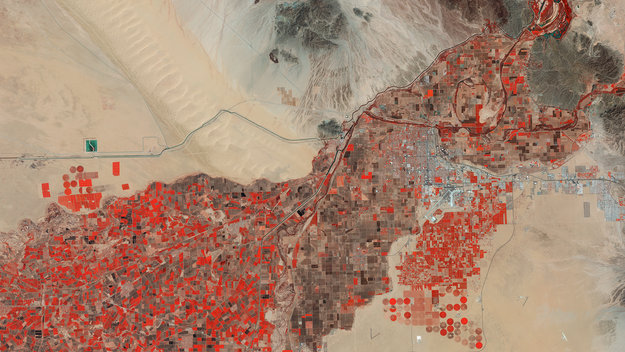
Earth observation image of the week: a Sentinel-2A image of Yuma in the US, also featured on the Earth from Space video programme
ČGS – Blok expertů MRS 23. 3. 2016
17.3.2016 13:10 Katedra geografie UP Olomouc Zveme Vás na přednášku v rámci Bloku expertů MRSFérové zdanění
která se uskuteční ve středu 23. března 2016 od 15.00 do 16.30 na učebně LP 5007 Přírodovědecké fakulty UP. Přednáší Jonáš Vnouček a Ondřej Kopečný (pozvánka).
Kosmické aktivity zvyšují bezpečí, i když letecká doprava narůstá
17.3.2016 12:39 Český Kosmický PortálESA a družicový operátor Inmarsat z Velké Británie pokračují ve vývoji komunikace vzduch-země skrze družice. Jde o součást evropského plánu zajistit bezpečnost letecké dopravy navzdory narůstajícímu provozu.
V části Zajímavé stránky (http
17.3.2016 12:00 Plzeňský kraj V části Zajímavé stránky (http://geoportal.plzensky-kraj.cz/gs/zajimave-stranky/) byl doplněn odkaz na Veřejný registr půdy - LPIS (http://eagri.cz/public/app/lpisext/lpis/verejny/), kterým Ministerstvo zemědělství zveřejňuje v elektronické podobě způsobem umožňujícím dálkový a nepřetržitý přístup základní údaje z veřejné části evidence využití půdy.V části Zajímavé stránky byl d
17.3.2016 12:00 Plzeňský kraj V části Zajímavé stránky byl doplněn odkaz na Veřejný registr půdy - LPIS, kterým Ministerstvo zemědělství zveřejňuje v elektronické podobě způsobem umožňujícím dálkový a nepřetržitý přístup základní údaje z veřejné části evidence využití půdy.Earth from Space
17.3.2016 11:48 ESA Observing the Earth
Join us Friday, 18 March, at 10:00 CET for the ‘Earth from Space’ video programme. This week features a Sentinel-2A image of Yuma in the US
ArcGIS Maps for Office 4.0
17.3.2016 10:10 ARCDATANová verze mapového klienta pro zobrazování dat v prostředí Microsoft Excel a Microsoft PowerPoint s sebou nejen řadu změn a vylepšení, ale i nové jméno – ArcGIS Maps for Office.
Smart mapping 
Nástroje smart mapping vyhodnocují charakter dat, se kterými právě pracujete, a nabízejí nejvhodnější styl jejich vykreslování. Funkce smart mapping jsou v této verzi rozšířené a zjednodušena je také manuální klasifikace dat.
Využijte datum a čas
Pokud data obsahují datum a čas, je možné je využít v animaci, která zobrazí změny v průběhu časového období. Navíc je možné data porovnávat s jinými časovými vrstvami, které vznikly v prostředí ArcGIS.
Filtrujte data 
Data v tabulkách je možné filtrovat standardním způsobem, nově však můžeme nastavovat filtr i výběrem z mapy.
Vždy aktuální mapa
Další důležité vylepšení přichází v podobě nastavení obnovovacích intervalů, které určují, za jak dlouho se načte aktuální verze vrstvy z portálu. Díky tomu je tedy možné sledovat, jak se dané jevy vyvíjí.
Prezentujte mapy interaktivně
Prostředí pro práci s mapami v aplikaci Microsoft PowerPoint je zcela přepracováno.
Chcete se o novinkách dozvědět více? Stáhněte si ArcGIS Maps for Office na stránkách Esri.

GISáček 2016 – výsledky
17.3.2016 9:56 GISportal.cz Včera (16. 3. 2016) se na půdě VŠB-TUO konal již 19. ročník studentské konference GISáček. Konference GISáček je každoroční součást univerzitního života, která je určená studentům vysokých škol, kteří zde mají možnost prezentovat výsledky svých odborných studentských prací. Tradičně ...odborný referent katastru nemovitostí - Technické sekce, odbor obnovy katastrálního operátu (1)
17.3.2016 9:00 ČÚZK - předpisy a opatření /Urady/Katastralni-urady/Katastralni-urady/Katastralni-urad-pro-Stredocesky-kraj/Volna-mista/odborny-referent-katastru-nemovitosti-Technick-(1)odborný referent katastru nemovitostí - Technické sekce, odbor obnovy katastrálního operátu (1)
17.3.2016 9:00 ČÚZK /Urady/Katastralni-urady/Katastralni-urady/Katastralni-urad-pro-Stredocesky-kraj/Volna-mista/odborny-referent-katastru-nemovitosti-Technick-(1)odborný referent katastru nemovitostí - Technické sekce, odbor obnovy katastrálního operátu (1)
17.3.2016 9:00 ČÚZK - volná místa /Urady/Katastralni-urady/Katastralni-urady/Katastralni-urad-pro-Stredocesky-kraj/Volna-mista/odborny-referent-katastru-nemovitosti-Technick-(1)odborný referent katastru nemovitostí - Technické sekce, odbor obnovy katastrálního operátu
17.3.2016 8:58 ČÚZK /Urady/Katastralni-urady/Katastralni-urady/Katastralni-urad-pro-Stredocesky-kraj/Volna-mista/odborny-referent-katastru-nemovitosti-Technicke-seodborný referent katastru nemovitostí - Technické sekce, odbor obnovy katastrálního operátu
17.3.2016 8:58 ČÚZK - volná místa /Urady/Katastralni-urady/Katastralni-urady/Katastralni-urad-pro-Stredocesky-kraj/Volna-mista/odborny-referent-katastru-nemovitosti-Technicke-seodborný referent katastru nemovitostí - Technické sekce, odbor obnovy katastrálního operátu
17.3.2016 8:58 ČÚZK - předpisy a opatření /Urady/Katastralni-urady/Katastralni-urady/Katastralni-urad-pro-Stredocesky-kraj/Volna-mista/odborny-referent-katastru-nemovitosti-Technicke-seLogo ČKS
17.3.2016 8:56 Česká kartografická společnost Výbor děkuje všem členům společnosti, kteří vyjádřili svůj postoj k návrhům nového loga ČKS. Z procesních důvodů výbor však zatím nerozhodl o konečném návrhu. Jakmile bude návrh nového loga uzavřen, budou všichni členové společnosti informováni. Předseda výboru ČKS V. TalhoferOdborný referent – referent katastru nemovitostí oddělení aktualizace, podatelna
17.3.2016 8:46 ČÚZK - volná místa /Urady/Katastralni-urady/Katastralni-urady/Katastralni-urad-pro-Stredocesky-kraj/Uredni-deska/Oznameni-a-jina-uredni-sdeleni/Volna-mista/Odborny-referent-–-referent-katastru-nemovitosti-oOdborný referent – referent katastru nemovitostí oddělení aktualizace, podatelna
17.3.2016 8:46 ČÚZK /Urady/Katastralni-urady/Katastralni-urady/Katastralni-urad-pro-Stredocesky-kraj/Uredni-deska/Oznameni-a-jina-uredni-sdeleni/Volna-mista/Odborny-referent-–-referent-katastru-nemovitosti-oOdborný referent – referent katastru nemovitostí oddělení aktualizace, podatelna
17.3.2016 8:46 ČÚZK - předpisy a opatření /Urady/Katastralni-urady/Katastralni-urady/Katastralni-urad-pro-Stredocesky-kraj/Uredni-deska/Oznameni-a-jina-uredni-sdeleni/Volna-mista/Odborny-referent-–-referent-katastru-nemovitosti-oO nás a naší mobilní aplikaci MAIA na Lupa.cz
17.3.2016 7:54 UpVision O nás a naší nové mobilní aplikaci MAIA pro všechny uživatele UAV, RC modelů a další, psal server Lupa.czVíce zde:
http://www.lupa.cz/clanky/ceska-aplikace-maia-nabizi-sluzby-pro-drony-a-bezpilotni-letani/
Dohoda o spolupráci mezi SPÚ a Sdruením místních samospráv ČR
17.3.2016 7:03 Zeměměřič Ústřední ředitelka SPÚ Svatava Maradová spolu s předsedou Sdruení místních samospráv ČR a poslancem EP Stanislavem Polčákem slavnostně podepsali 15. března...Gefos zve na školení MISYS
17.3.2016 7:00 Česká asociace pro geoinformace Společnost GEFOS, kolektivní člen CAGI, zve na školení:Vážení zákazníci,
srdečně Vás zveme na další školení MISYS, které se bude konat 26. 4. 2016 na adrese naší společnosti: Plánská 6, 370 07 České Budějovice.
Začátek školení je plánován na 9:00. Registrace účastníků bude probíhat od 8:30 ve vestibulu budovy u hlavního vchodu.
Jedná
NEW WAWE - prodloužení termínu
17.3.2016 7:00 Česká asociace pro geoinformace Organizátoři 8. ročníku mezinárodní studentské konference NEW WAVE v Praze, pořádané ve dnech 19. – 20. května 2016, prodloužili termín pro podání abstraktů na 31. března 2016.Mezinárodní geografická konference pro doktorandy a mladé výzkumníky New Wave se na Přírodovědecké fakultě UK koná již od roku 2009.
Veškeré informace o konferenci naleznete na jejích
Urban Atlas
17.3.2016 1:00 Cenia - Katalog metadat ČR - INSPIRE Urban Atlas je součástí služby Copernicus pro monitorování území. Obsahuje podrobné informace o využití území ve městech a jejich okolí a jeho změnách. Jedná se o vektorová data v měřítku cca 1 : 10 000, která jsou vytvářena nad družicovými snímky každých 6 let; aktuálně jsou k dispozici data za roky 2006 a 2012 včetně změnové vrstvy. Mapována jsou evropská města s více než 50 000 obyvateli (od r. 2012, pro předchozí roky města s více než 100 000 obyvateli). Technické specifikace k jednotlivým vrstvám HRL jsou k dispozici na http://land.copernicus.eu/user-corner/technical-library, obecné informace na http://land.copernicus.eu.Bakalářské práce – zadání nových témat
16.3.2016 23:27 Katedra geografie UP Olomouc Nová témata bakalářských prací z geografie, s předpokládaným odevzdáním v dubnu 2017, jsou zveřejněna prostřednictvím tohoto seznamu (PDF) – část témat je již předjednána, ostatní témata jsou nabídnuta potenciálním zájemcům (výběr probíhá dohodou s příslušným vyučujícím).K tématu práce se studenti musí přihlásit přes STAG nejpozději do 15. dubna 2016 – týká se to všech studentů 2. ročníku bakalářského studia Regionální geografie a také těch studentů 2. ročníku bakalářského studia Geografie (uč.), kteří se rozhodli napsat svou bakalářskou práci z geografie.
Postup zadání tématu práce je následující: student ve spolupráci s vedoucím práce vyplní ve STAGu přihlášku Podklad pro zadání kvalifikační práce a podepsaný výtisk této přihlášky odevzdá na sekretariátě katedry, kde mu bude vystaveno oficiální zadání práce.
SMĚROVÉ SLOUPKY A ODRAZKY ZÁSADY PRO POUŽÍVÁNÍ
16.3.2016 20:45 Asociace poskytovatelů služeb v pozemkových úpravách Předmět technických podmínek TP 58 – 02/2016 Předmětem těchto technických podmínek (dále TP) jsou zásady pro používání směrových sloupků a odrazek. TP obsahují rozdělení směrových sloupků a odrazek a zásady pro jejich umístění, osazování a používání na pozemních komunikacích. Ke stažení zdeOdborný seminář pro správce zemědělské půdy
16.3.2016 20:27
Zemědělské půdě se věnujeme v CleverMaps dlouhodobě. Rozhodli jsme se proto o svoje zkušenosti podělit s těmi, kteří se evidenci půdy dlouhodobě zaobírají. Ve spolupráci s Institutem vzdělávání v zemědělství se uskutečnil v pátek 11. března 2016 v Klatovech seminář, jehož lektoři byli naši kolegové Oldřich Kahoun a Daniel Vráblík. Přítomné posluchače informovali o katastru nemovitostí, pozemkových úpravách, dani z nemovitých věcí a dalších zajímavostech týkajících se správy půdy. V příštím měsíci budou kolegové pokračovat v této činnosti i v dalších okresech ČR.


Reality Modeling for Everyone
16.3.2016 19:51 Bentley Systems<p><em>Press Coverage</em></p>
<p>Informed Infrastructure</p>
<a href="https://informedinfrastructure.com/20922/reality-modeling-for-everyone/" class="blue-button" target="_blank">Read the article</a>
Odvolání výuky KGG/GCR2 ve čtvrtek 17. 3. 2016
16.3.2016 18:09 Katedra geografie UP Olomouc Z důvodu pracovní cesty vyučujícího neproběhne ve čtvrtek 17. března 2016 přednáška z předmětu KGG/GCR2 Regionální geografie ČR 2 (doc. Szczyrba). Způsob náhrady bude domluven se studenty v následující hodině výuky.Zeměměřický western
16.3.2016 17:17 Zeměměřič Krátký film z prostředí Divokého západu reiséra Scotta Blake vyprávý příběh vládního inspektora někdy kolem roku 1848 při vytyčování pozemků na západní hranici.20160316 - Personalistika
16.3.2016 15:47 ČÚZK - předpisy a opatření /Aktuality-resort/2016/20160316-Personalistika20160316 - Personalistika
16.3.2016 15:47 ČÚZK - předpisy a opatření Oznámení o vyhlášení výběrového řízení na služební místo personalistika - informace zde.20160316 - Personalistika
16.3.2016 15:47 ČÚZK - předpisy a opatření Oznámení o vyhlášení výběrového řízení na služební místo personalistika - informace zde.20160316 - Personalistika
16.3.2016 15:47 ČÚZK - předpisy a opatření /Aktuality-resort/20160316-PersonalistikaČGS – Cestovatelský úterek 22. 3. 2016 (Japonsko)
16.3.2016 15:37 Katedra geografie UP Olomouc Zveme Vás na přednášku v cyklu Cestovatelské úterkyJaponsko: Vlakem po Kjúšú a Honšú
která se uskuteční v úterý 22. března 2016 od 18.30 do 20.00 na učebně LP 2005. Přednáší Michal Lehnert (pozvánka).