


![]()

zprávy
zdroje zpráv:Krátka správa č. 51/2023
22.11.2023 11:18 Komora geodetů a kartografů SRThe post Krátka správa č. 51/2023 appeared first on Komora geodetov a kartografov.
Krátka správa č. 50/2023
22.11.2023 11:16 Komora geodetů a kartografů SRThe post Krátka správa č. 50/2023 appeared first on Komora geodetov a kartografov.
Krátka správa č. 49/2023
22.11.2023 11:14 Komora geodetů a kartografů SRThe post Krátka správa č. 49/2023 appeared first on Komora geodetov a kartografov.
Krátka správa č. 48/2023
22.11.2023 11:09 Komora geodetů a kartografů SRThe post Krátka správa č. 48/2023 appeared first on Komora geodetov a kartografov.
20231122 - volné místo - Odborný/vrchní referent v odd. akt. a dokument. KN KP Chomutov na KÚ pro ÚK
22.11.2023 10:49 ČÚZK /Urady/Katastralni-urady/Katastralni-urady/Katastralni-urad-pro-Ustecky-kraj/Katastralni-pracoviste/KP-Chomutov/O-uradu/Aktuality/20231122-volne-misto-Odborny-vrchni-referent-v-odd20231122 - volné místo - Odborný/vrchní referent v odd. akt. a dokument. KN KP Chomutov na KÚ pro ÚK
22.11.2023 10:49 ČÚZK - předpisy a opatření Katastrální úřad pro Ústecký kraj - Katastrální pracoviště Chomutov zveřejnil novou aktualitu: Nabídka volného místa - Odborný / vrchní referent v oddělení aktualizace a dokumentace katastru nemovitostí KP Chomutov na KÚ pro Ústecký kraj20231122 - volné místo - Odborný/vrchní referent v odd. akt. a dokument. KN KP Chomutov na KÚ pro ÚK
22.11.2023 10:44 ČÚZK /Urady/Katastralni-urady/Katastralni-urady/Katastralni-urad-pro-Ustecky-kraj/O-uradu/Aktuality/20231122-volne-misto-Odborny-vrchni-referent-v-odd20231122 - volné místo - Odborný/vrchní referent v odd. akt. a dokument. KN KP Chomutov na KÚ pro ÚK
22.11.2023 10:44 ČÚZK - předpisy a opatření Katastrální úřad pro Ústecký kraj - Katastrální pracoviště Chomutov zveřejnil novou aktualitu: Nabídka volného místa - Odborný / vrchní referent v oddělení aktualizace a dokumentace katastru nemovitostí KP Chomutov pro Ústecký krajOdborný / vrchní referent v oddělení aktualizace a dokumentace katastru nemovitostí KP Chomutov na K
22.11.2023 10:35 ČÚZK /Urady/Katastralni-urady/Katastralni-urady/Katastralni-urad-pro-Ustecky-kraj/Uredni-deska/Oznameni-a-jina-uredni-sdeleni/Volna-mista/DMS/Odborny-vrchni-referent-v-oddeleni-aktualizace-a-dOdborný / vrchní referent v oddělení aktualizace a dokumentace katastru nemovitostí KP Chomutov na K
22.11.2023 10:35 ČÚZK - volná místa Katastrální úřad pro Ústecký kraj Katastrální pracoviště Chomutov vypisuje výběrové řízení na místo Odborný / vrchní referent v oddělení aktualizace a dokumentace katastru nemovitostí KP Chomutov na KOdborný / vrchní referent v oddělení aktualizace a dokumentace katastru nemovitostí KP Chomutov na K
22.11.2023 10:35 ČÚZK - předpisy a opatření Katastrální úřad pro Ústecký kraj Katastrální pracoviště Chomutovvypisuje výběrové řízení na místo
Odborný / vrchní referent v oddělení aktualizace a dokumentace katastru nemovitostí KP Chomutov na KÚ pro Ústecký kraj
Výběrové řízení na KP Havlíčkův Brod
22.11.2023 9:25 ČÚZK - předpisy a opatření Katastrální úřad pro Vysočinu - Katastrální pracoviště Havlíčkův Brod zveřejnil novou aktualitu: Výběrové řízení na služební místo vrchní referent/rada - oddělení aktualizace KN II - Katastrálního pracoviště Havlíčkův Brod.Výběrové řízení na KP Havlíčkův Brod
22.11.2023 9:25 ČÚZK /Urady/Katastralni-urady/Katastralni-urady/Katastralni-urad-pro-Vysocinu/O-uradu/Aktuality/Vyberove-rizeni-na-KP-Havlickuv-BrodUnlocking Europe’s satellite navigation potential at NAVISP Industry Days
22.11.2023 9:23 ESA Navigation
Leading positioning, navigation and timing experts from companies and research institutions across Europe met last week at ESA’s NAVISP Industry Days, a two-day workshop dedicated to discussing trends and opportunities in this field.
Vrchní referent-rada - aktualizace KN II KP Havlíčkův Brod
22.11.2023 8:43 ČÚZK /Urady/Katastralni-urady/Katastralni-urady/Katastralni-urad-pro-Vysocinu/Uredni-deska/Oznameni-a-jina-uredni-sdeleni/Volna-mista/DMS/Vrchni-referent-rada-aktualizace-KN-II-KP-HavlickuVrchní referent-rada - aktualizace KN II KP Havlíčkův Brod
22.11.2023 8:43 ČÚZK - volná místa Katastrální úřad pro Vysočinu Katastrální pracoviště Havlíčkův Brod vypisuje výběrové řízení na místo Vrchní referent-rada - aktualizace KN II KP Havlíčkův BrodVrchní referent-rada - aktualizace KN II KP Havlíčkův Brod
22.11.2023 8:43 ČÚZK - předpisy a opatření Katastrální úřad pro Vysočinu Katastrální pracoviště Havlíčkův Brodvypisuje výběrové řízení na místo
Vrchní referent-rada - aktualizace KN II KP Havlíčkův Brod
Technická odstávka Portálu ESKN
21.11.2023 21:45
ÚGKK SR
Úrad geodézie, kartografie a katastra SR v snahe vylepšiť svoje služby bude realizovať aktualizáciu informačných systémov. Z tohto dôvodu je potrebné kvôli lepšej funkčnosti portálov ESKN urobiť TECHNICKÚ ODSTÁVKU. Dňa 24.11.2023 (piatok) od 18:00 hod. do 27.11.2023 (pondelok) do 12:00 hod. bude technická odstávka elektronických služieb katastra nehnuteľností, nakoľko bude realizovaná aktualizácia infraštruktúry systému Elektronických služieb katastra nehnuteľností.
#PortálESKN #od:24.11.2023@18:00 #do:27.11.2023@12:00
Webinář - Správa kusovníku a vlastností o sestavě pro Fusion 360
21.11.2023 14:18 Adeon
Zaregistrujte se na náš plánovaný webinář, na kterém vám předvedeme několik tipů a triků jak efektivně pracovat kusovníkem a vlastnostmi […]
The post Webinář - Správa kusovníku a vlastností o sestavě pro Fusion 360 appeared first on Adeon CZ.
Webinář - Správa kusovníku a vlastností o sestavě pro Fusion 360
21.11.2023 14:18 AdeonZaregistrujte se na náš plánovaný webinář, na kterém vám předvedeme několik tipů a triků jak efektivně pracovat kusovníkem a vlastnostmi […]
The post Webinář - Správa kusovníku a vlastností o sestavě pro Fusion 360 appeared first on Adeon CZ.
odborný referent/vrchní referent - návrh zápisu v katastru v oddělení dokumentace KN KP Písek (ID SM
21.11.2023 13:45 ČÚZK /Urady/Katastralni-urady/Katastralni-urady/Katastralni-urad-pro-Jihocesky-kraj/Uredni-deska/Oznameni-a-jina-uredni-sdeleni/Volna-mista/DMS/odborny-referent-vrchni-referent-navrh-zapisu-v-kaodborný referent/vrchní referent - návrh zápisu v katastru v oddělení dokumentace KN KP Písek (ID SM
21.11.2023 13:45 ČÚZK - volná místa Katastrální úřad pro Jihočeský kraj Katastrální pracoviště Písek vypisuje výběrové řízení na místo odborný referent/vrchní referent - návrh zápisu v katastru v oddělení dokumentace KN KP Písek (ID SModborný referent/vrchní referent - návrh zápisu v katastru v oddělení dokumentace KN KP Písek (ID SM
21.11.2023 13:45 ČÚZK - předpisy a opatření Katastrální úřad pro Jihočeský kraj Katastrální pracoviště Písekvypisuje výběrové řízení na místo
odborný referent/vrchní referent - návrh zápisu v katastru v oddělení dokumentace KN KP Písek (ID SM 30000248/30003872)
Projekt Get It Sorted úspěšně předán - tisková zpráv
21.11.2023 13:24 T-MAPYThe post Projekt Get It Sorted úspěšně předán - tisková zpráv appeared first on T-MAPY spol. s r.o..
Projekt Get It Sorted úspěšně předán - tisková zpráva
21.11.2023 13:24 T-MAPYThe post Projekt Get It Sorted úspěšně předán - tisková zpráva appeared first on T-MAPY spol. s r.o..
Projekt Get It Sorted úspěšně předán
21.11.2023 13:24 T-MAPYThe post Projekt Get It Sorted úspěšně předán appeared first on T-MAPY spol. s r.o..
20231121 - volné místo - vrchní referent/rada v odd. hosp. správy kanceláře ředitele KÚ na KÚ pro UK
21.11.2023 13:18 ČÚZK - předpisy a opatření Katastrální úřad pro Ústecký kraj zveřejnil novou aktualitu: Nabídka volného pracovního místa - Vrchní referent / rada v oddělení hospodářské správy kanceláře ředitele KÚ na KÚ pro Ústecký kraj20231121 - volné místo - vrchní referent/rada v odd. hosp. správy kanceláře ředitele KÚ na KÚ pro UK
21.11.2023 13:18 ČÚZK /Urady/Katastralni-urady/Katastralni-urady/Katastralni-urad-pro-Ustecky-kraj/O-uradu/Aktuality/20231121-volne-misto-vrchni-referent-rada-v-odd-ho20231121 - volné místo - vrchní referent/rada v odd. hosp. správy kanceláře ředitele KÚ na KÚ pro UK
21.11.2023 13:18 ČÚZK - předpisy a opatření Katastrální úřad pro Ústecký kraj zveřejnil novou aktualitu: Nabídka volného pracovního místa - Vrchní referent / rada v oddělení hospodářské správy kanceláře ředitele KÚ na KÚ pro Ústecký krajVrchní referent / rada v oddělení hospodářské správy kanceláře ředitele KÚ na KÚ pro Ústecký kraj
21.11.2023 13:03 ČÚZK - volná místa Katastrální úřad pro Ústecký kraj kancelář ředitele vypisuje výběrové řízení na místo Vrchní referent / rada v oddělení hospodářské správy kanceláře ředitele KÚ na KÚ pro Ústecký krajVrchní referent / rada v oddělení hospodářské správy kanceláře ředitele KÚ na KÚ pro Ústecký kraj
21.11.2023 13:03 ČÚZK - předpisy a opatření Katastrální úřad pro Ústecký kraj kancelář ředitelevypisuje výběrové řízení na místo
Vrchní referent / rada v oddělení hospodářské správy kanceláře ředitele KÚ na KÚ pro Ústecký kraj
Vrchní referent / rada v oddělení hospodářské správy kanceláře ředitele KÚ na KÚ pro Ústecký kraj
21.11.2023 13:03 ČÚZK /Urady/Katastralni-urady/Katastralni-urady/Katastralni-urad-pro-Ustecky-kraj/Uredni-deska/Oznameni-a-jina-uredni-sdeleni/Volna-mista/DMS/Vrchni-referent-rada-v-oddeleni-hospodarske-spravyCairt and Wivern Earth Explorer candidates go forward
21.11.2023 12:52 ESA Observing the Earth
ESA has reached a significant milestone in its commitment towards a deeper understanding of Earth's dynamic processes and addressing pressing environmental challenges with the selection of two new candidates – Cairt and Wivern – to progress to the next development phase as part of the process of realising the Agency’s eleventh Earth Explorer satellite mission.
Vrchní referent/rada v oddělení obnovy katastrálního operátu č.3 na Technické sekci
21.11.2023 12:47 ČÚZK - předpisy a opatření Katastrální úřad pro Jihomoravský kraj technická sekcevypisuje výběrové řízení na místo
Vrchní referent/rada v oddělení obnovy katastrálního operátu č.3 na Technické sekci
Vrchní referent/rada v oddělení obnovy katastrálního operátu č.3 na Technické sekci
21.11.2023 12:47 ČÚZK - volná místa Katastrální úřad pro Jihomoravský kraj technická sekce vypisuje výběrové řízení na místo Vrchní referent/rada v oddělení obnovy katastrálního operátu č.3 na Technické sekciVrchní referent/rada v oddělení obnovy katastrálního operátu č.3 na Technické sekci
21.11.2023 12:47 ČÚZK /Urady/Katastralni-urady/Katastralni-urady/Katastralni-urad-pro-Jihomoravsky-kraj/Uredni-deska/Oznameni-a-jina-uredni-sdeleni/Volna-mista/DMS/Vrchni-referent-rada-v-oddeleni-obnovy-katastr-(1)Omezený telefonický kontakt
21.11.2023 11:52 ČÚZK - předpisy a opatření Katastrální úřad pro Středočeský kraj - Katastrální pracoviště Kolín zveřejnil novou aktualitu:Omezený telefonický kontakt Dobrý den,Ve dnech 22.11.2023 a 23.12.2023 bude omezen telefonický kontakt kvůli prováděným úpravám na telefonické ústředně.
Pro dotazy lze využít emailovou adresu: kp.kolin@cuzk.cz
Děkujeme za pochopení
Omezený telefonický kontakt
21.11.2023 11:52 ČÚZK /Urady/Katastralni-urady/Katastralni-urady/Katastralni-urad-pro-Stredocesky-kraj/Katastralni-pracoviste/KP-Kolin/O-uradu/Aktuality/Omezeny-telefonicky-kontaktodborný referent - Katastrální pracoviště Moravské Budějovice
21.11.2023 10:59 ČÚZK /Urady/Katastralni-urady/Katastralni-urady/Katastralni-urad-pro-Vysocinu/O-uradu/Aktuality/odborny-referent-Katastralni-pracoviste-Moravske-Bodborný referent - Katastrální pracoviště Moravské Budějovice
21.11.2023 10:59 ČÚZK - předpisy a opatření Katastrální úřad pro Vysočinu - Katastrální pracoviště Moravské Budějovice zveřejnil novou aktualitu: Výběrové řízení na služební místo odborný referent - Katastrální pracoviště Moravské Budějovice.Pracovník/pracovnice vztahů k veřejnosti + Telefonista/ka
21.11.2023 10:16 Zeměměřický úřad Zeměměřický úřadvypisuje výběrové řízení na místo
Pracovník/pracovnice vztahů k veřejnosti + Telefonista/ka
Pracovník/pracovnice vztahů k veřejnosti + Telefonista/ka
21.11.2023 10:16 ČÚZK - předpisy a opatření Zeměměřický úřadvypisuje výběrové řízení na místo
Pracovník/pracovnice vztahů k veřejnosti + Telefonista/ka
Pracovník/pracovnice vztahů k veřejnosti + Telefonista/ka
21.11.2023 10:16 ČÚZK - volná místa Zeměměřický úřad vypisuje výběrové řízení na místo Pracovník/pracovnice vztahů k veřejnosti + Telefonista/kaPracovník/pracovnice vztahů k veřejnosti + Telefonista/ka
21.11.2023 10:16 ČÚZK /Urady/Zememericky-urad/Volna-mista/DMS/Pracovnik-pracovnice-vztahu-k-verejnosti-TelefonisOdborný referent - KP Moravské Budějovice
21.11.2023 10:08 ČÚZK - volná místa Katastrální úřad pro Vysočinu Katastrální pracoviště Moravské Budějovice vypisuje výběrové řízení na místo Odborný referent - KP Moravské BudějoviceOdborný referent - KP Moravské Budějovice
21.11.2023 10:08 ČÚZK /Urady/Katastralni-urady/Katastralni-urady/Katastralni-urad-pro-Vysocinu/Uredni-deska/Oznameni-a-jina-uredni-sdeleni/Volna-mista/DMS/Odborny-referent-KP-Moravske-BudejoviceOdborný referent - KP Moravské Budějovice
21.11.2023 10:08 ČÚZK - předpisy a opatření Katastrální úřad pro Vysočinu Katastrální pracoviště Moravské Budějovicevypisuje výběrové řízení na místo
Odborný referent - KP Moravské Budějovice
Autodesk cyber week u ARKANCE – sleva až 25 % na oblíbené produkty
21.11.2023 0:00 Arkance SystemsCyber Week je tady! Pořiďte si CAD, CAM, BIM nebo multimédia software od Autodesku za zvýhodněné ceny.
Zpráva Autodesk cyber week u ARKANCE – sleva až 25 % na oblíbené produkty pochází z arkance-systems.cz.
Autodesk Cyber Week u ARKANCE – sleva až 25 % na oblíbené produkty
21.11.2023 0:00 Arkance SystemsCyber Week je tady! Pořiďte si CAD, CAM, BIM nebo multimédia software od Autodesku za zvýhodněné ceny.
Zpráva Autodesk Cyber Week u ARKANCE – sleva až 25 % na oblíbené produkty pochází z arkance-systems.cz.
BLACK FRIDAY Autodesk licencí
21.11.2023 0:00 Adeon
V rámci světového oblíbeného slevového svátku Black Friday pro vás Autodesk přichystal nikoliv jeden den slev, ale rovnou celý týden […]
The post BLACK FRIDAY Autodesk licencí appeared first on Adeon CZ.
BLACK FRIDAY Autodesk licencí
21.11.2023 0:00 AdeonV rámci světového oblíbeného slevového svátku Black Friday pro vás Autodesk přichystal nikoliv jeden den slev, ale rovnou celý týden […]
The post BLACK FRIDAY Autodesk licencí appeared first on Adeon CZ.
EUSPA Open Days 2023, where space becomes more than space
20.11.2023 16:51 European GNSS Agency
The EUSPA Open Days offer the public an opportunity to learn about and experience applications based on the EU Space Programme and its components, Galileo, EGNOS, Copernicus, GOVSATCOM/IRIS2 and SSA.
This year we invite you to our Prague headquarters from 1 to 2 December 2023
Hop on Galileo-enabled trams: 6, 8, 12, 17, 25, 1 and get off at Strossmayerovo Náměstí or take a ride down the metro line C and stop at Vltavska.
What to expect?
- Unique insights into the agency’s work
- An immersive Copernicus exhibition which will make your social media feed blow up
- Discover our approach to space debris management
- Fun learning opportunities for youngsters or adults wanting to experience childlike playfulness
- Exciting seminars, space workshops, competitions, and prizes
- Discussions with EUSPA experts about career or space entrepreneurship opportunities
"EUSPA Open Days is our agency’s signature event specifically conceived for the general public to highlight the role of EU Space Programme as well our agency, in the lives of Europeans," says EUSPA Executive Director, Rodrigo da Costa. "I look forward to welcoming you!"
Stay tuned for more information and keep an eye on our EUSPA Open Days 2023 page.
We are looking forward to welcoming you onboard!
Media note: This feature can be republished without charge provided the European Union Agency for the Space Programme (EUSPA) is acknowledged as the source at the top or the bottom of the story. You must request permission before you use any of the photographs on the site. If you republish, we would be grateful if you could link back to the EUSPA website (http://www.euspa.europa.eu).
EUSPA Open Days 2023, where space becomes more than space
20.11.2023 16:51 European GNSS AgencyThe EUSPA Open Days offer the public an opportunity to learn about and experience applications based on the EU Space Programme and its components, Galileo, EGNOS, Copernicus, GOVSATCOM/IRIS2 and SSA.
This year, our Prague headquarters will be open to all on 1 December from 4.00 pm to 6.00 pm and on 2 December 2023 from 9.00 am to 6.00 pm.
Hop on Galileo-enabled trams: 6, 8, 12, 17, 25, 1 and get off at Strossmayerovo Náměstí or take a ride down the metro line C and stop at Vltavska.
What to expect?
- Unique insights into the agency’s work
- An immersive Copernicus exhibition which will make your social media feed blow up
- Discover our approach to space debris management
- Fun learning opportunities for youngsters or adults wanting to experience childlike playfulness
- Exciting seminars, space workshops, competitions, and prizes
- Discussions with EUSPA experts about career or space entrepreneurship opportunities
"EUSPA Open Days is our agency’s signature event specifically conceived for the general public to highlight the role of EU Space Programme as well our agency, in the lives of Europeans," says EUSPA Executive Director, Rodrigo da Costa. "I look forward to welcoming you!"
Stay tuned for more information and keep an eye on our EUSPA Open Days 2023 page.
We are looking forward to welcoming you!
Read in Czech
Media note: This feature can be republished without charge provided the European Union Agency for the Space Programme (EUSPA) is acknowledged as the source at the top or the bottom of the story. You must request permission before you use any of the photographs on the site. If you republish, we would be grateful if you could link back to the EUSPA website (http://www.euspa.europa.eu).
EUSPA Open Days 2023, where space becomes more than space
20.11.2023 16:51 European GNSS AgencyThe EUSPA Open Days offer the public an opportunity to learn about and experience applications based on the EU Space Programme and its components, Galileo, EGNOS, Copernicus, GOVSATCOM/IRIS2 and SSA.
This year, our Prague headquarters will be open to all on 1 December from 4.00 pm to 6.00 pm and on 2 December 2023 from 9.00 am to 6.00 pm.
Hop on Galileo-enabled trams: 6, 8, 12, 17, 25, 1 and get off at Strossmayerovo Náměstí or take a ride down the metro line C and stop at Vltavska.
What to expect?
- Unique insights into the agency’s work
- An immersive Copernicus exhibition which will make your social media feed blow up
- Discover our approach to space debris management
- Fun learning opportunities for youngsters or adults wanting to experience childlike playfulness
- Exciting seminars, space workshops, competitions, and prizes
- Discussions with EUSPA experts about career or space entrepreneurship opportunities
"EUSPA Open Days is our agency’s signature event specifically conceived for the general public to highlight the role of EU Space Programme as well our agency, in the lives of Europeans," says EUSPA Executive Director, Rodrigo da Costa. "I look forward to welcoming you!"
Stay tuned for more information and keep an eye on our EUSPA Open Days 2023 page.
We are looking forward to welcoming you!
Media note: This feature can be republished without charge provided the European Union Agency for the Space Programme (EUSPA) is acknowledged as the source at the top or the bottom of the story. You must request permission before you use any of the photographs on the site. If you republish, we would be grateful if you could link back to the EUSPA website (http://www.euspa.europa.eu).
Arctic Weather Satellite in shape
20.11.2023 15:44 ESA Observing the Earth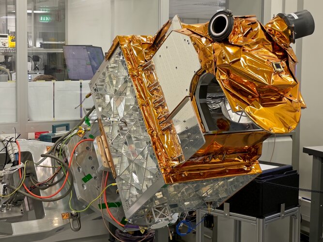
Embracing the New Space approach, it has taken just 36 months to develop and build ESA’s Arctic Weather Satellite. Now complete, this remarkable microsatellite has been shipped from OHB in Sweden to Germany where it is starting a series of tests to make sure that it will survive liftoff next year and its subsequent life in orbit.
Účetní ekonomicko-správního oddělení
20.11.2023 14:45 ČÚZK /Urady/Katastralni-urady/Katastralni-urady/Katastralni-urad-pro-Liberecky-kraj/Volna-mista/DMS/Ucetni-ekonomicko-spravniho-oddeleniÚčetní ekonomicko-správního oddělení
20.11.2023 14:45 ČÚZK - předpisy a opatření Katastrální úřad pro Liberecký kraj kancelář ředitelevypisuje výběrové řízení na místo
Účetní ekonomicko-správního oddělení
Účetní ekonomicko-správního oddělení
20.11.2023 14:45 ČÚZK - volná místa Katastrální úřad pro Liberecký kraj kancelář ředitele vypisuje výběrové řízení na místo Účetní ekonomicko-správního odděleníZkrácení otevírací doby [Knihovna geografie, byTopic]
20.11.2023 12:10 Katedra aplikované geoinformatiky a kartografie Přf UK ve středu 22. listopadu. Knihovna geografie bude otevřena pouze do 16:00.Novinky v aplikaci Geoprohlížeč
20.11.2023 10:00 ČÚZK - Geoportál Novinky v aplikaci GeoprohlížečByla publikována nová verze aplikace obsahující tato vylepšení funkcí:
Rozšířené možnosti výběru polygonu pro funkci "Export dat".
Je možné převzít právě označený prvek s otevřeným vyskakovacím oknem. V mapovém okně stačí kliknout například na polygon katastrálního území nebo klad listů a při volbě funkce "Exportovat data" v "Seznamu vrstev" zvolit v rozšířených možnostech "Převzít označenou geometrii".
Podpora připojení služeb vektorových dlaždic.
Do aplikace lze nyní přidat externí službu vektorových dlaždic publikovaných z ArcGIS serveru.
Službě je možné nastavit vlastní styly pomocí publikovaného JSON souboru (možnosti vrstvy v "Seznamu vrstev").
Vylepšené ovládání widgetu "Výpis souřadnic bodu".
Po najetí myší na řádek výsledku se zobrazí EPSG souřadnicového systému, pro lepší orientaci mezi výsledky.
Spolehlivější sdílení vlastní webové mapy.
Funkce sdílení webové mapy je nyní spolehlivější při vyšším počtu položek v "Seznamu vrstev".
Lze sdílet i vektorové dlaždice s nastaveným stylem.
Novinky v aplikaci Geoprohlížeč
20.11.2023 10:00 ČÚZK - Geoportál Novinky v aplikaci GeoprohlížečByla publikována nová verze aplikace obsahující tato vylepšení funkcí:
Rozšířené možnosti výběru polygonu pro funkci "Export dat".
Je možné převzít právě označený prvek s otevřeným vyskakovacím oknem. V mapovém okně stačí kliknout například na polygon katastrálního území nebo klad listů a při volbě funkce "Exportovat data" v "Seznamu vrstev" zvolit v rozšířených možnostech "Převzít označenou geometrii".
Podpora připojení služeb vektorových dlaždic.
Do aplikace lze nyní přidat externí službu vektorových dlaždic publikovaných z ArcGIS serveru.
Službě je možné nastavit vlastní styly pomocí publikovaného JSON souboru (možnosti vrstvy v "Seznamu vrstev").
Vylepšené ovládání widgetu "Výpis souřadnic bodu".
Po najetí myší na řádek výsledku se zobrazí EPSG souřadnicového systému, pro lepší orientaci mezi výsledky.
Spolehlivější sdílení vlastní webové mapy.
Funkce sdílení webové mapy je nyní spolehlivější při vyšším počtu položek v "Seznamu vrstev".
Lze sdílet i vektorové dlaždice s nastaveným stylem.
VŘ archivář/ka
20.11.2023 9:27 ČÚZK /Urady/Zememericky-urad/Uredni-deska/Oznameni-a-jina-uredni-sdeleni/Volna-mista/DMS/VR-archivar-kaVŘ archivář/ka
20.11.2023 9:27 Zeměměřický úřad Zeměměřický úřadvypisuje výběrové řízení na místo
VŘ archivář/ka
VŘ archivář/ka
20.11.2023 9:27 ČÚZK - předpisy a opatření Zeměměřický úřadvypisuje výběrové řízení na místo
VŘ archivář/ka
VŘ archivář/ka
20.11.2023 9:27 ČÚZK - volná místa Zeměměřický úřad vypisuje výběrové řízení na místo VŘ archivář/kaDružicové metody v teorii a praxi. Pozvánka na 26. ročník konference v Brně
19.11.2023 21:28 ZeměměřičÚstav geodézie Fakulty stavební Vysokého učení technické v Brně zve na 26. ročník konference s mezinárodní účastí. Konference Družicové metody v teorii a praxi se uskuteční v prezenční i online formě ve čtvrtek 1. února 2024 v Brně. Na konferenci se může hlásit na webu – uzávěrka přihlášek na konferenci je 22. ledna 2024. Rámcový program konference Program je zaměřen především na aplikace družicových měření […]
The post Družicové metody v teorii a praxi. Pozvánka na 26. ročník konference v Brně appeared first on Zeměměřič.
DAEX DESIGN Professional 24
19.11.2023 11:30 ŠPINAR - software Nová verze DAEX DESIGN Professional 24 s akčními bonusy !DAEX DESIGN Professional 24
19.11.2023 11:30 ŠPINAR - softwareNová verze DAEX DESIGN Professional 24 s akčními bonusy !
The post DAEX DESIGN Professional 24 appeared first on ŠPINAR – software.
DAEX DESIGN Professional 24
19.11.2023 11:30 ŠPINAR - softwareNová verze DAEX DESIGN Professional 24 s akčními bonusy !
The post DAEX DESIGN Professional 24 appeared first on ŠPINAR – software.
Earth from Space: North Channel
17.11.2023 10:00 ESA Observing the Earth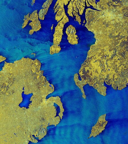 Image:
The North Channel, between Northern Ireland and Scotland, is featured in this false-colour radar image from the Copernicus Sentinel-1 mission.
Image:
The North Channel, between Northern Ireland and Scotland, is featured in this false-colour radar image from the Copernicus Sentinel-1 mission.
Nedostupné produkční ISÚI a VDP
16.11.2023 14:07 ČÚZK /ruian/Editacni-agendovy-system-ISUI/Provozni-informace-a-odstavky/Archiv-PROD/Nedostupne-produkcni-ISUI-a-VDP-(7)Regionálne stretnutia 2023
16.11.2023 12:49 Komora geodetů a kartografů SRThe post Regionálne stretnutia 2023 appeared first on Komora geodetov a kartografov.
Sleva 8,44 % na Fusion 360 Extensions
16.11.2023 12:19 AdeonAutodesk přináší jedinečnou příležitost pro všechny designéry a inženýry – exkluzivní slevu 8,44 % na nová roční předplatná oblíbených rozšíření […]
The post Sleva 8,44 % na Fusion 360 Extensions appeared first on Adeon CZ.
Sleva 8,44 % na Fusion 360 Extensions
16.11.2023 12:19 AdeonAutodesk přináší jedinečnou příležitost pro všechny designéry a inženýry – exkluzivní slevu 8,44 % na nová roční předplatná oblíbených rozšíření […]
The post Sleva 8,44 % na Fusion 360 Extensions appeared first on Adeon CZ.
Citování kartografických dokumentů [Knihovna geografie, byTopic]
16.11.2023 11:35 Katedra aplikované geoinformatiky a kartografie Přf UK online publikaci společně vydaly Univerzita Karlova (Přírodovědecká fakulta) a Národní knihovna ČR (Knihovnický institut)Unlocking the Future: Secure SATCOM in the EU - A Comprehensive Overview
16.11.2023 11:32 European GNSS Agency
Demand for secure satellite communications (SATCOM) is on the rise. The use of SATCOM supporting Crisis Management, Surveillance, and Key Infrastructure in the EU will increase by a factor of 14 between 2025 and 2040, reaching around 186 Gbps by 2040 (Fixed Satellite Services only).
Such a large increase is driven by geopolitical trends, climate change, economic growth, national and international regulations, and EU policies such as the EU Space for Security and Defence strategy, recently approved by the Council.
In this context, and with GOVSATCOM and IRIS2 underway, experts at the European Union Agency for the Space Programme (EUSPA) produced the first-ever Secure SATCOM Market and User Technology Report. The long study aims to help relevant public and private actors identify business opportunities, set the basis for developing the market, and enable the realization of benefits from satellite communications, both in the EU and worldwide.
Download the report here
To further communicate the importance of secure SATCOM across sectors and support users in their safety and security-sensitive missions, EUSPA is planning to wrap up on the recently concluded ENTRUSTED and shed some light on what is coming next.
Eventually, as a promoter of Research and Innovation, EUSPA published last month a Horizon Europe call, which features a specific topic dedicated to GOVSATCOM.
Check this out: GOVSATCOM Horizon Europe funding opportunity of 10 M€
EUSPA is organising a dedicated webinar focusing on Secure SATCOM on December 12, 2023 from 10:00 to 12:00.
In this webinar, you will:
- Explore market opportunities enabled by secure Satellite Communications in the EU
- Discover relevant trends that will drive the market, as well as innovation and technological advancements in the field
- Know more about the EUSPA network of users for secure SATCOM and how to become a member to join events, share experience and voice your opinion
- Learn more about funding opportunities provided by EUSPA
See the full agenda is here.
Join us here
Media note: This feature can be republished without charge provided the European Union Agency for the Space Programme (EUSPA) is acknowledged as the source at the top or the bottom of the story. You must request permission before you use any of the photographs on the site. If you republish, we would be grateful if you could link back to the EUSPA website (http://www.euspa.europa.eu).
Unlocking the Future: Secure SATCOM in the EU - A Comprehensive Overview
16.11.2023 11:32 European GNSS AgencyDemand for secure satellite communications (SATCOM) is on the rise. The use of SATCOM supporting Crisis Management, Surveillance, and Key Infrastructure in the EU will increase by a factor of 14 between 2025 and 2040, reaching around 186 Gbps by 2040 (Fixed Satellite Services only).
Such a large increase is driven by geopolitical trends, climate change, economic growth, national and international regulations, and EU policies such as the EU Space for Security and Defence strategy, recently approved by the Council.
In this context, and with GOVSATCOM and IRIS2 underway, experts at the European Union Agency for the Space Programme (EUSPA) produced the first-ever Secure SATCOM Market and User Technology Report. The long study aims to help relevant public and private actors identify business opportunities, set the basis for developing the market, and enable the realization of benefits from satellite communications, both in the EU and worldwide.
Download the report here
To further communicate the importance of secure SATCOM across sectors and support users in their safety and security-sensitive missions, EUSPA is planning to wrap up on the recently concluded ENTRUSTED and shed some light on what is coming next.
Eventually, as a promoter of Research and Innovation, EUSPA published last month a Horizon Europe call, which features a specific topic dedicated to GOVSATCOM.
Check this out: GOVSATCOM Horizon Europe funding opportunity of 10 M€
EUSPA is organising a dedicated webinar focusing on Secure SATCOM on December 12, 2023 from 10:00 to 12:00.
In this webinar, you will:
- Explore market opportunities enabled by secure Satellite Communications in the EU
- Discover relevant trends that will drive the market, as well as innovation and technological advancements in the field
- Know more about the EUSPA network of users for secure SATCOM and how to become a member to join events, share experience and voice your opinion
- Learn more about funding opportunities provided by EUSPA
See the full agenda is here.
Join us here
Media note: This feature can be republished without charge provided the European Union Agency for the Space Programme (EUSPA) is acknowledged as the source at the top or the bottom of the story. You must request permission before you use any of the photographs on the site. If you republish, we would be grateful if you could link back to the EUSPA website (http://www.euspa.europa.eu).
Geoinformatika v životním prostředí (pozvánka)
16.11.2023 8:02 GISportal.cz
Katedra geoinformatiky fakulty životního prostředí UJEP zve na seminář pro odbornou veřejnost a studenty s názvem Geoinformatika v životním prostředí, který se bude konat dne 6. 1 2024 od 9 do 17 hodin na Universitě Jana Evangelisty Purkyně v Ústí nad Labem. Témata budou zahrnovat využití široké škály geoinformatických nástrojů ve zkoumání různých aspektů životního prostředí, ať […]
The post Geoinformatika v životním prostředí (pozvánka) appeared first on GISportal.cz.
Geoinformatika v životním prostředí (pozvánka)
16.11.2023 8:02 GISportal.czKatedra geoinformatiky fakulty životního prostředí UJEP zve na seminář pro odbornou veřejnost a studenty s názvem Geoinformatika v životním prostředí, který se bude konat dne 6. 1 2024 od 9 do 17 hodin na Universitě Jana Evangelisty Purkyně v Ústí nad Labem. Témata budou zahrnovat využití široké škály geoinformatických nástrojů ve zkoumání různých aspektů životního prostředí, ať […]
The post Geoinformatika v životním prostředí (pozvánka) appeared first on GISportal.cz.
APGEO - Vedení APG jednalo s ministrem zemědělství
16.11.2023 1:00 Asociace podnikatelů v geomatice Zástupci APG znovu jednali s ministrem zemědělství o budoucnosti financování pozemkových úprav.Valné zhromaždenie KPÚ SR
15.11.2023 17:23 Komora pozemkových úprav SR
V piatok 8.12.2023 sa bude v priestoroch PF UK Bratislava konať 8. riadne valné zhromaždenie KPÚ SR a Odborná konferencia o pozemkových úpravách
Valné zhromaždenie KPÚ SR
15.11.2023 17:23 Komora pozemkových úprav SRV piatok 8.12.2023 o 8.00 sa bude konať 8. riadne valné zhromaždenie KPÚ SR a po jeho skončení od 13.30 sa uskutoční Odborná konferencia o pozemkových úpravách (3.ročník Konferencie o pozemkovom práve). Miesto konania PF UK Bratislava (Amfiteáter), Šafárikovo námestie […]
Článok Valné zhromaždenie KPÚ SR je zobrazený ako prvý na Pozemkové úpravy - kpu.sk.
Seminář ICONCLASS & e-ilustrace [Knihovna geografie, byTopic]
15.11.2023 15:20 Katedra aplikované geoinformatiky a kartografie Přf UK se uskuteční v rámci končícího projektu Česká knižní ilustrace v raném novověkuItaly's Mount Etna spews lava
15.11.2023 15:00 ESA Observing the Earth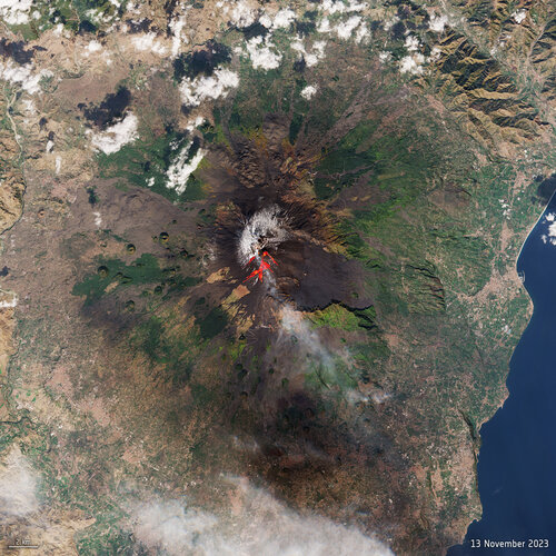 Image:
One of the world’s most active volcanoes, Mount Etna, erupted on Sunday – spewing lava and clouds of ash high over the Mediterranean island of Sicily. This image, captured on 13 November by the Copernicus Sentinel-2 mission, has been processed using the mission’s shortwave-infrared bands to show the lava flow at the time of acquisition.
Image:
One of the world’s most active volcanoes, Mount Etna, erupted on Sunday – spewing lava and clouds of ash high over the Mediterranean island of Sicily. This image, captured on 13 November by the Copernicus Sentinel-2 mission, has been processed using the mission’s shortwave-infrared bands to show the lava flow at the time of acquisition.
Oznámení
15.11.2023 13:07 ČÚZK /Urady/Katastralni-urady/Katastralni-urady/Katastralni-urad-pro-Olomoucky-kraj/Katastralni-pracoviste/KP-Olomouc/O-uradu/Aktuality/OznameniOznámení
15.11.2023 13:07 ČÚZK - předpisy a opatření Katastrální úřad pro Olomoucký kraj - Katastrální pracoviště Olomouc zveřejnil novou aktualitu:OZNÁMENÍ
Ve středu 29. listopadu 2023 budou Katastrální úřad pro Olomoucký kraj a Katastrální pracoviště Olomouc z důvodu přerušení dodávky elektřiny UZAVŘENY.Děkujeme za pochopení.
TZ: Systém vzdělávání v BIM pro pracovníky veřejné správy
15.11.2023 13:06 czBIMČeská agentura pro standardizaci představí Systém vzdělávání v BIM pro pracovníky veřejné správy.Ve spolupráci s czBIM uspořádá sérii seminářů v jednotlivých krajích. Pokud má mít...
Článek TZ: Systém vzdělávání v BIM pro pracovníky veřejné správy se nejdříve objevil na czBIM.
Oznámení
15.11.2023 12:39 ČÚZK - předpisy a opatření Katastrální úřad pro Olomoucký kraj - Katastrální pracoviště Olomouc zveřejnil novou aktualitu:OZNÁMENÍ
Ve středu 29. listopadu 2023 budou Katastrální úřad pro Olomoucký kraj a Katastrální pracoviště Olomouc z důvodu přerušení dodávky elektřiny UZAVŘENY.Děkujeme za pochopení.
Oznámení
15.11.2023 12:39 ČÚZK - předpisy a opatření Katastrální úřad pro Olomoucký kraj zveřejnil novou aktualitu:OZNÁMENÍ
Ve středu 29. listopadu 2023 budou Katastrální úřad pro Olomoucký kraj a Katastrální pracoviště Olomouc z důvodu přerušení dodávky elektřiny UZAVŘENY.Děkujeme za pochopení.
Oznámení
15.11.2023 12:39 ČÚZK /Urady/Katastralni-urady/Katastralni-urady/Katastralni-urad-pro-Olomoucky-kraj/O-uradu/Aktuality/Oznameni20231115 - VŘ Účtárna
15.11.2023 11:03 ČÚZK - předpisy a opatření Český úřad zeměměřický a katastrální zveřejnil novou aktualitu: Oznámení o vyhlášení výběrového řízení na obsazení pracovního místa Účtárna.20231115 - VŘ Účtárna
15.11.2023 11:03 ČÚZK - aktuality v resortu Oznámení o vyhlášení výběrového řízení na obsazení pracovního místa Účtárna.MetOp Second Generation weather satellite pair show off
15.11.2023 10:57 ESA Observing the Earth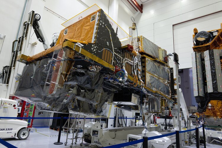
Having satellites in different types of orbit is essential to delivering data to forecast the weather accurately. With the first Meteosat Third Generation Imager satellite safely in geostationary orbit since December 2022, it’s also time to focus on its polar-orbiting cousin, the MetOp Second Generation mission. And now, for the first time, two MetOp Second Generation satellites have been brought together to stand side-by-side for testing.
Účtárna
15.11.2023 10:56 ČÚZK - předpisy a opatření Český úřad zeměměřický a katastrálnívypisuje výběrové řízení na místo
Účtárna