


![]()

zprávy
zdroje zpráv:HRDLIČKA Holding se rozrůstá o další společnost
10.11.2023 10:25 Hrdlička Nová společnost nese název GEODATA UkrainePodzimní grilovačka na naší zahradě se vyvedla na jedničku
10.11.2023 10:25 Hrdlička Poslední pátek v září jsme pořádali tradiční firemní neformální akci Grilovačka na centrále společnosti v Praze.Byli jsme součástí studentské soutěže GISáček 2019
10.11.2023 10:25 Hrdlička V březnu proběhl další ročník konference GISáček, který je součástí Sympozia GIS Ostrava.Podpořili jsme akci “Divadélkování ve Ville Hrdlička”
10.11.2023 10:25 Hrdlička Naše společnost se stala partnerem akce "Divadélkování ve ville Hrdlička", kterou pořádá Horizont HG 2014. z.ú za podpory České Lípy.Spustili jsme nový web HRDLIČKA
10.11.2023 10:25 Hrdlička Od 1. prosince jsme sputili nový web, který je více přehlednější..Získali jsme osvědčení Rodinný podnik
10.11.2023 10:25 Hrdlička Naše mateřská společnost Hrdlička Group spol. s r. o. získala osvědčení RODINNÝ PODNIK.Budování marketingu ve firmě Hrdlička
10.11.2023 10:25 Hrdlička Jaký byl vývoj marketingového oddělení a je pro geodézii či geoinformatiku potřeba?Podílíme se na přípravě VRT Vysočina II. fáze
10.11.2023 10:25 Hrdlička Cestu mezi Prahou a Brnem pomůže projekt zkrátit až o 1 hodinu.Ministryně financí ČR ve Ville Hrdlička
10.11.2023 10:25 Hrdlička Město Česká Lípa pozvalo paní Schillerovou, která strávila celý den s představiteli města.DRONY PRO UKRAJINU – tisková zpráva
10.11.2023 10:25 Hrdlička Ke dni 31. 3. byla vydána tisková zpráv k projektu Drony pro Ukrajinu.Řízení majetkoprávní dokumentace
10.11.2023 10:25 Hrdlička Poskytujeme velkým vlastníkům inženýrských sítí dokonalý majetkoprávní a geodetický servis.Video o BIM od Asociace podnikatelů v geomatice
10.11.2023 10:25 Hrdlička Chceme-li bydlet v chytrých městech, měli bychom je umět chytře stavět.Účastnili jsme se 30. Silniční konference v Ostravě
10.11.2023 10:25 Hrdlička Společný stánek firem HRDLIČKA a GEOSTAR představil kvalitu i inovace.Podcast s Ing. Martinem Hrdličkou
10.11.2023 10:25 Hrdlička Zakladatel společnosti Martin Hrdlička reaguje na digitalizaci stavebního řízení.Laserové skenování Čiperovy vily
10.11.2023 10:25 Hrdlička V létě roku 2021 jsme provedli zaměření této racionálně klasicistní vily ve Zlíně.Přinášíme Vám 2. díl o službě UtilityReport
10.11.2023 10:25 Hrdlička Ve 2. díle Vám ukážeme, jak si lze online ulehčit práci s hromadným podáním žádosti.Promo video – HRDLIČKA “Geodézie v souvislostech”
10.11.2023 10:25 Hrdlička Děláme geodézii v souvislostech na více než 110 % 🙂 Podívejte se na naše promo video, kde je v hlavní roli náš geodet.Hrdlička a Digitální technická mapa ČR
10.11.2023 10:25 Hrdlička Služby pro vlastníky a správce dopravní a technické infrastruktury.Úpravna vody – vodní nádrž Vír
10.11.2023 10:25 Hrdlička Vytvořili jsme BIM model areálu v okolí vírské přehrady.Získali jsme certifikát společensky odpovědné firmy
10.11.2023 10:25 Hrdlička Ve spolupráci se společností Remobil jsme se zapojili do projektu pro ochranu životního prostředí..Podívejte se z výšky na železniční viadukty
10.11.2023 10:25 Hrdlička V Olomouckém kraji jsme vytvořili 3D vizualizace historických staveb.Jak efektivně zadržet vodu v krajině?
10.11.2023 10:25 Hrdlička V týdeníku Echo24 probíráme situaci pozemkových úprav.Naše společnost podporuje pohyb
10.11.2023 10:25 Hrdlička Sport, je nejen nedílnou součástí našich životů, ale učí nás i k týmové spolupráci.Pasportizace zeleně na dálnicích ŘSD ČR
10.11.2023 10:25 Hrdlička Jedná se o jeden z nově vznikajících pasportů, které slouží pro podporu provozu na ŘSD.Nové funkcionality ve službě UtilityReport
10.11.2023 10:25 Hrdlička Neusínáme na vavřínech. Naše služby se snažíme rozvíjet a přidávat jim hodnoty.Relax a pohoda v Krkonoších
10.11.2023 10:25 Hrdlička Letos jsme si užili teambuilding na Lesní plovárně – Retroparku Sejfy v obci Mladé Buky.Rozhovor s novým výrobním ředitelem Ing. Petrem Pavelkou
10.11.2023 10:25 Hrdlička Od 1. ledna 2019 se stal výrobním ředitelem společnosti HRDLIČKA spol. s r. o. Ing. Petr Pavelka.Firemní teambuilding – Váňův statek
10.11.2023 10:25 Hrdlička 26. - 27. 5. 2019 se uskutečnil firemní teambuilding na Váňově statku v Dubovicích na Vysočině.6. porada vedení firem HRDLIČKA Holdingu
10.11.2023 10:25 Hrdlička Villa Hrdlička v České Lípě se stala místem slavnostní události.Zúčastnili jsme se akce Do práce na kole
10.11.2023 10:25 Hrdlička V květnu se naše společnost zúčastnila oblíbené sportovní akce Do práce na kole. Přihlásili se 2 týmy.Již skoro rok pomáháme Ukrajině
10.11.2023 10:25 Hrdlička K ruské agresi nejsme lhostejní a přicházíme s projekty na podporu Ukrajiny.Úpravy výměnného formátu záborových elaborátů
10.11.2023 10:25 Hrdlička ŘSD ČR spolu se SŽ workshop uspořádalo v loňském roce.Do Varšavy za Obnovou Ukrajiny
10.11.2023 10:25 Hrdlička Mezinárodní veletrh Rebuild Ukraine se v únoru konal v Polsku.UtilityReport získalo ocenění Zlatý erb 2019 v Ústeckém kraji
10.11.2023 10:25 Hrdlička Služba UtilityReport získala ocenění Zlatý erb v soutěži o "nejlepší elektronickou službu" v Ústeckém kraji.Jak si udržet přední místo na trhu?
10.11.2023 10:25 Hrdlička Zeptali jsme se Martina Hrdličky na „návod", jak přesáhnout z rodinné firmy na prosperující holding.Celofiremní školení proběhlo letos distančně
10.11.2023 10:25 Hrdlička S ohledem na vládní nařízení související s pandemií Covid-19 se uskutečnilo celofiremní školení on-line.Sbíráme drony pro Ukrajinu
10.11.2023 10:25 Hrdlička Ve spolupráci s ukrajinskou ambasádou, firmami HRDLIČKA Holding a Asociací podnikatelů v geomatice pořádáme sbírku dronů na pomoc Ukrajině.3D a BIM – základ moderní výstavby
10.11.2023 10:25 Hrdlička Věnujeme se zpracováním dokumentace stávajících stavebních objektů na základě..Výměna stožárového vedení na trase Jihlava – Telč
10.11.2023 10:25 Hrdlička Úspěšně jsme dokončili zajímavou zakázku rekonstrukce vedení 110 kV.Výměnný formát liniových akcí
10.11.2023 10:25 Hrdlička V loňském roce jsme se dostali do týmu, který aktualizoval předpis C4.MawisPhoto na stavbě města Chotěboř
10.11.2023 10:25 Hrdlička Město využilo beta verzi naší služby na stavbě: ButtulovaPasportizace dopravních staveb ŘSD v BIM
10.11.2023 10:25 Hrdlička Zpracovali jsme pilotní zakázku pasportizace mostů a propustků ve formě BIM modelů.Earth from Space: Autumn in Japan
10.11.2023 10:00 ESA Observing the Earth Image:
This image, from the Copernicus Sentinel-3 mission on 1 November 2023, captures the colours of autumn over the Japanese archipelago.
Image:
This image, from the Copernicus Sentinel-3 mission on 1 November 2023, captures the colours of autumn over the Japanese archipelago.
Galileo Second Generation satellite aces first hardware tests
10.11.2023 9:20 ESA Navigation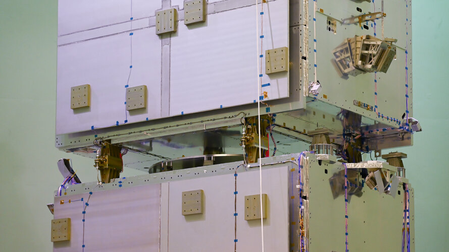
The new Galileo satellite model from Thales Alenia Space underwent mechanical and signal performance testing this summer at ESA’s ESTEC Test Centre. Structural models resisted launch-like noise and vibrations while an electrical model proved its ability to send Galileo signals - a major milestone in the development of Galileo’s Second Generation.
Rada/odborný rada – vedoucí oddělení právních vztahů k nemovitostem
10.11.2023 8:25 ČÚZK - předpisy a opatření Katastrální úřad pro Moravskoslezský kraj Katastrální pracoviště Karvinávypisuje výběrové řízení na místo
Rada/odborný rada – vedoucí oddělení právních vztahů k nemovitostem
Rada/odborný rada – vedoucí oddělení právních vztahů k nemovitostem
10.11.2023 8:25 ČÚZK /Urady/Katastralni-urady/Katastralni-urady/Katastralni-urad-pro-Moravskoslezsky-kraj/Uredni-deska/Oznameni-a-jina-uredni-sdeleni/Volna-mista/DMS/Rada-odborny-rada-–-vedouci-oddeleni-pravnich-vztaRada/odborný rada – vedoucí oddělení právních vztahů k nemovitostem
10.11.2023 8:25 ČÚZK - volná místa Katastrální úřad pro Moravskoslezský kraj Katastrální pracoviště Karviná vypisuje výběrové řízení na místo Rada/odborný rada – vedoucí oddělení právních vztahů k nemovitostemNové letecké měřické snímky ČR
10.11.2023 8:01 ČÚZK - Geoportál Nové letecké měřické snímky ČRV aplikaci Archiv si již můžete prohlédnout letecké měřické snímky z nejnovějšího snímkování západní části území ČR v roce 2023.
Nové letecké snímky lze již také objednávat v aplikaci e-shop.
Nové letecké měřické snímky ČR
10.11.2023 8:01 ČÚZK - Geoportál Nové letecké měřické snímky ČRV aplikaci Archiv si již můžete prohlédnout letecké měřické snímky z nejnovějšího snímkování západní části území ČR v roce 2023.
Nové letecké snímky lze již také objednávat v aplikaci e-shop.
Nové letecké měřické snímky ČR
10.11.2023 8:01 ČÚZK - Geoportál Nové letecké měřické snímky ČRV aplikaci Archiv si již můžete prohlédnout letecké měřické snímky z nejnovějšího snímkování západní části území ČR v roce 2023.
Nové letecké snímky lze již také objednávat v aplikaci e-shop.
Nové letecké měřické snímky ČR
10.11.2023 8:01 ČÚZK - Geoportál Nové letecké měřické snímky ČRV aplikaci Archiv si již můžete prohlédnout letecké měřické snímky z nejnovějšího snímkování západní části území ČR v roce 2023.
Nové letecké snímky lze již také objednávat v aplikaci e-shop.
Nové letecké měřické snímky ČR
10.11.2023 8:01 ČÚZK - Geoportál Nové letecké měřické snímky ČRV aplikaci Archiv si již můžete prohlédnout letecké měřické snímky z nejnovějšího snímkování západní části území ČR v roce 2023.
Nové letecké snímky lze již také objednávat v aplikaci e-shop.
Nové letecké měřické snímky ČR
10.11.2023 8:01 ČÚZK - Geoportál Nové letecké měřické snímky ČRV aplikaci Archiv si již můžete prohlédnout letecké měřické snímky z nejnovějšího snímkování západní části území ČR v roce 2023.
Nové letecké snímky lze již také objednávat v aplikaci e-shop.
Nové letecké měřické snímky ČR
10.11.2023 8:01 ČÚZK - Geoportál Nové letecké měřické snímky ČRV aplikaci Archiv si již můžete prohlédnout letecké měřické snímky z nejnovějšího snímkování západní části území ČR v roce 2023.
Nové letecké snímky lze již také objednávat v aplikaci e-shop.
Nové letecké měřické snímky ČR
10.11.2023 8:01 ČÚZK - Geoportál Nové letecké měřické snímky ČRV aplikaci Archiv si již můžete prohlédnout letecké měřické snímky z nejnovějšího snímkování západní části území ČR v roce 2023.
Nové letecké snímky lze již také objednávat v aplikaci e-shop.
Nové letecké měřické snímky ČR
10.11.2023 8:01 ČÚZK - Geoportál Nové letecké měřické snímky ČRV aplikaci Archiv si již můžete prohlédnout letecké měřické snímky z nejnovějšího snímkování západní části území ČR v roce 2023.
Nové letecké snímky lze již také objednávat v aplikaci e-shop.
Nové letecké měřické snímky ČR
10.11.2023 8:01 ČÚZK - Geoportál Nové letecké měřické snímky ČRV aplikaci Archiv si již můžete prohlédnout letecké měřické snímky z nejnovějšího snímkování západní části území ČR v roce 2023.
Nové letecké snímky lze již také objednávat v aplikaci e-shop.
Nové letecké měřické snímky ČR
10.11.2023 8:01 ČÚZK - Geoportál Nové letecké měřické snímky ČRV aplikaci Archiv si již můžete prohlédnout letecké měřické snímky z nejnovějšího snímkování západní části území ČR v roce 2023.
Nové letecké snímky lze již také objednávat v aplikaci e-shop.
Nové letecké měřické snímky ČR
10.11.2023 8:01 ČÚZK - Geoportál Nové letecké měřické snímky ČRV aplikaci Archiv si již můžete prohlédnout letecké měřické snímky z nejnovějšího snímkování západní části území ČR v roce 2023.
Nové letecké snímky lze již také objednávat v aplikaci e-shop.
Nové letecké měřické snímky ČR
10.11.2023 8:01 ČÚZK - Geoportál Nové letecké měřické snímky ČRV aplikaci Archiv si již můžete prohlédnout letecké měřické snímky z nejnovějšího snímkování západní části území ČR v roce 2023.
Nové letecké snímky lze již také objednávat v aplikaci e-shop.
Nové letecké měřické snímky ČR
10.11.2023 8:01 ČÚZK - Geoportál Nové letecké měřické snímky ČRV aplikaci Archiv si již můžete prohlédnout letecké měřické snímky z nejnovějšího snímkování západní části území ČR v roce 2023.
Nové letecké snímky lze již také objednávat v aplikaci e-shop.
Nové letecké měřické snímky ČR
10.11.2023 8:01 ČÚZK - Geoportál Nové letecké měřické snímky ČRV aplikaci Archiv si již můžete prohlédnout letecké měřické snímky z nejnovějšího snímkování západní části území ČR v roce 2023.
Nové letecké snímky lze již také objednávat v aplikaci e-shop.
Nové letecké měřické snímky ČR
10.11.2023 8:01 ČÚZK - Geoportál Nové letecké měřické snímky ČRV aplikaci Archiv si již můžete prohlédnout letecké měřické snímky z nejnovějšího snímkování západní části území ČR v roce 2023.
Nové letecké snímky lze již také objednávat v aplikaci e-shop.
Nové letecké měřické snímky ČR
10.11.2023 8:01 ČÚZK - Geoportál Nové letecké měřické snímky ČRV aplikaci Archiv si již můžete prohlédnout letecké měřické snímky z nejnovějšího snímkování západní části území ČR v roce 2023.
Nové letecké snímky lze již také objednávat v aplikaci e-shop.
Nové letecké měřické snímky ČR
10.11.2023 8:01 ČÚZK - Geoportál Nové letecké měřické snímky ČRV aplikaci Archiv si již můžete prohlédnout letecké měřické snímky z nejnovějšího snímkování západní části území ČR v roce 2023.
Nové letecké snímky lze již také objednávat v aplikaci e-shop.
Nové letecké měřické snímky ČR
10.11.2023 8:01 ČÚZK - Geoportál Nové letecké měřické snímky ČRV aplikaci Archiv si již můžete prohlédnout letecké měřické snímky z nejnovějšího snímkování západní části území ČR v roce 2023.
Nové letecké snímky lze již také objednávat v aplikaci e-shop.
Nové letecké měřické snímky ČR
10.11.2023 8:01 ČÚZK - Geoportál Nové letecké měřické snímky ČRV aplikaci Archiv si již můžete prohlédnout letecké měřické snímky z nejnovějšího snímkování západní části území ČR v roce 2023.
Nové letecké snímky lze již také objednávat v aplikaci e-shop.
Nové letecké měřické snímky ČR
10.11.2023 8:01 ČÚZK - Geoportál Nové letecké měřické snímky ČRV aplikaci Archiv si již můžete prohlédnout letecké měřické snímky z nejnovějšího snímkování západní části území ČR v roce 2023.
Nové letecké snímky lze již také objednávat v aplikaci e-shop.
Nové letecké měřické snímky ČR
10.11.2023 8:01 ČÚZK - Geoportál Nové letecké měřické snímky ČRV aplikaci Archiv si již můžete prohlédnout letecké měřické snímky z nejnovějšího snímkování západní části území ČR v roce 2023.
Nové letecké snímky lze již také objednávat v aplikaci e-shop.
návrh zápisu v katastru
10.11.2023 7:37 ČÚZK /Urady/Katastralni-urady/Katastralni-urady/Katastralni-urad-pro-Olomoucky-kraj/Volna-mista/DMS/navrh-zapisu-v-katastrunávrh zápisu v katastru
10.11.2023 7:37 ČÚZK - předpisy a opatření Katastrální úřad pro Olomoucký kraj Katastrální pracoviště Šumperkvypisuje výběrové řízení na místo
návrh zápisu v katastru
návrh zápisu v katastru
10.11.2023 7:37 ČÚZK - volná místa Katastrální úřad pro Olomoucký kraj Katastrální pracoviště Šumperk vypisuje výběrové řízení na místo návrh zápisu v katastru20231110 - volné místo – Vedoucí OPV k nemovitostem KP Děčín na KÚ pro Ústecký kraj
10.11.2023 6:36 ČÚZK - předpisy a opatření Katastrální úřad pro Ústecký kraj - Katastrální pracoviště Děčín zveřejnil novou aktualitu: Nabídka volného místa představeného - Vedoucí oddělení právních vztahů k nemovitostem Katastrálního pracoviště Děčín na Katastrálním úřadu pro Ústecký kraj20231110 - volné místo – Vedoucí OPV k nemovitostem KP Děčín na KÚ pro Ústecký kraj
10.11.2023 6:36 ČÚZK /Urady/Katastralni-urady/Katastralni-urady/Katastralni-urad-pro-Ustecky-kraj/Katastralni-pracoviste/KP-Decin/O-uradu/Aktuality/20231110-volne-misto-–-Vedouci-OPV-k-nemovitostem20231110 - volné místo – Vedoucí OPV k nemovitostem KP Děčín na KÚ pro Ústecký kraj
10.11.2023 6:36 ČÚZK - předpisy a opatření Katastrální úřad pro Ústecký kraj - Katastrální pracoviště Děčín zveřejnil novou aktualitu: Nabídka volného místa představeného - Vedoucí oddělení právních vztahů k nemovitostem Katastrálního pracoviště Děčín na Katastrálním úřadu pro Ústecký kraj20231110 - volné místo – Vedoucí OPV k nemovitostem KP Děčín na KÚ pro Ústecký kraj
10.11.2023 6:36 ČÚZK /Urady/Katastralni-urady/Katastralni-urady/Katastralni-urad-pro-Ustecky-kraj/O-uradu/Aktuality/20231110-volne-misto-–-Vedouci-OPV-k-nemovitostem-Vedoucí oddělení právních vztahů k nemovitostem Katastrálního pracoviště Děčín na Katastrálním úřadu
10.11.2023 6:33 ČÚZK - předpisy a opatření Katastrální úřad pro Ústecký kraj Katastrální pracoviště Děčínvypisuje výběrové řízení na místo
Vedoucí oddělení právních vztahů k nemovitostem Katastrálního pracoviště Děčín na Katastrálním úřadu pro Ústecký kraj
Vedoucí oddělení právních vztahů k nemovitostem Katastrálního pracoviště Děčín na Katastrálním úřadu
10.11.2023 6:33 ČÚZK /Urady/Katastralni-urady/Katastralni-urady/Katastralni-urad-pro-Ustecky-kraj/Uredni-deska/Oznameni-a-jina-uredni-sdeleni/Volna-mista/DMS/Vedouci-oddeleni-pravnich-vztahu-k-nemovitostem-KaVedoucí oddělení právních vztahů k nemovitostem Katastrálního pracoviště Děčín na Katastrálním úřadu
10.11.2023 6:33 ČÚZK - volná místa Katastrální úřad pro Ústecký kraj Katastrální pracoviště Děčín vypisuje výběrové řízení na místo Vedoucí oddělení právních vztahů k nemovitostem Katastrálního pracoviště Děčín na Katastrálním úřaduSložitý svět jedním číslem [Knihovna geografie, byTopic]
9.11.2023 10:10 Katedra aplikované geoinformatiky a kartografie Přf UK aneb Česko v indexechNová aplikace Pressure Drops pro výpočet tlakové ztráty v Autodesk Revit
9.11.2023 10:07 Arkance SystemsNovinka z vlastního vývoje pro české a slovenské projektanty TZB - plné využití BIM modelu v Autodesk Revit.
Zpráva Nová aplikace Pressure Drops pro výpočet tlakové ztráty v Autodesk Revit pochází z arkance-systems.cz.
Nová aplikace Pressure Drops pro výpočet tlakové ztráty v Autodesk Revit
9.11.2023 10:07 Arkance SystemsNovinka z vlastního vývoje pro české a slovenské projektanty TZB - plné využití BIM modelu v Revitu
Zpráva Nová aplikace Pressure Drops pro výpočet tlakové ztráty v Autodesk Revit pochází z arkance-systems.cz.
EU Space Applications to Fish Plastics Out of our Oceans and Rivers
9.11.2023 9:50 European GNSS Agency
Did you know that of the 300 million tonnes of plastic produced every year, an estimated 26 million eventually ends up in the ocean? As a result, some estimates suggest there are 5.25 trillion pieces of plastic floating around the oceans and washing up onto beaches and coastal areas.
There are options to tackle this plastic sea party! Thanks to initiatives like the CASSINI Prize for digital space applications, we now have a range of innovative, space-based solutions ready to detect, monitor and remove plastics, microplastics and other litter from our oceans and waterways.
“Addressing the ocean's plastic problem starts with identifying and tracking the debris, which is exactly what each of our winning applications is doing, essential information for authorities or NGOs,” says Rodrigo da Costa, Executive Director of the EU Agency for the Space Programme (EUSPA).
CASSINI is the European Commission’s initiative to support entrepreneurs, start-ups and SMEs developing innovative applications and services that leverage the EU Space Programme. Dedicated to promoting the commercialisation of Galileo, EGNOS and Copernicus data and services, EUSPA is actively involved in the initiative.
With a total prize purse of EUR 2.85 million, the Maritime CASSINI Prize for Digital Space Applications sought innovative commercial solutions that leverage Copernicus, Europe’s Earth Observation programme; Galileo, the EU’s Global Navigation Satellite System; and/or EGNOS, the European Geostationary Navigation Overlay System – used in combination with other data sources – to track and remove marine plastic pollution.
Because the contest aimed to create a new ecosystem of entrepreneurs, applications were limited to SMEs having a close-to-market solution.
After a rigorous review process and a challenging demonstration requirement where applicants had to prove their solution’s effectiveness in real-world conditions, EUSPA and the European Commission announced the winners during the EU Space Week 2023 in Sevilla, Spain.
The winners
- Coastal Marine Litter Observatory by SCIDRONES: Using an innovative combination of Copernicus multi-spectral data with high-resolution drone imagery and advanced AI-algorithms, this application helps differentiate between plastic pollution and natural debris sources such as driftwood and seaweed. Local authorities can use the application to guide their cleanup operations, allocating resources to those beaches and environments most affected by plastic pollution.
- Eyes on Plastic by EOMAP: This data-driven web app combines Sentinel-2 optical imagery and commercial optical satellite imagery, on-site cameras, cloud-based big data processing chains, Earth Observation analytics and crowdsourcing to identify, map and monitor plastic pollution in near real-time. The solution looks to help governmental stakeholders meet their mandates for managing and reporting plastic pollution, including that found in rivers.
- Ocean Plastic Alert and Tracking by GEOMATYS Combining satellite images with meteorological and oceanographic models, this application is designed to detect debris at sea from space and predict its drift. By coupling ocean current and wind models with satellite observations, the solution can make forecasts both forwards and backwards in time. This allows coastal authorities to locate and predict where the front of plastic and debris is after a major weather crisis that causes navigational safety issues. It also optimises the collection of debris in collaboration with the likes of fishing boats.
All three winners received a EUR 950,000.00 cash prize, which will be used to further develop, scale up and, ultimately, give the real push for the commercialisation and promotion of their applications.
Media note: This feature can be republished without charge provided the European Union Agency for the Space Programme (EUSPA) is acknowledged as the source at the top or the bottom of the story. You must request permission before you use any of the photographs on the site. If you republish, we would be grateful if you could link back to the EUSPA website (http://www.euspa.europa.eu).
EU Space Applications to Fish Plastics Out of our Oceans and Rivers
9.11.2023 9:50 European GNSS AgencyDid you know that of the 300 million tonnes of plastic produced every year, an estimated 26 million eventually ends up in the ocean? As a result, some estimates suggest there are 5.25 trillion pieces of plastic floating around the oceans and washing up onto beaches and coastal areas.
There are options to tackle this plastic sea party! Thanks to initiatives like the CASSINI Prize for digital space applications, we now have a range of innovative, space-based solutions ready to detect, monitor and remove plastics, microplastics and other litter from our oceans and waterways.
“Addressing the ocean's plastic problem starts with identifying and tracking the debris, which is exactly what each of our winning applications is doing, essential information for authorities or NGOs,” says Rodrigo da Costa, Executive Director of the EU Agency for the Space Programme (EUSPA).
CASSINI is the European Commission’s initiative to support entrepreneurs, start-ups and SMEs developing innovative applications and services that leverage the EU Space Programme. Dedicated to promoting the commercialisation of Galileo, EGNOS and Copernicus data and services, EUSPA is actively involved in the initiative.
With a total prize purse of EUR 2.85 million, the Maritime CASSINI Prize for Digital Space Applications sought innovative commercial solutions that leverage Copernicus, Europe’s Earth Observation programme; Galileo, the EU’s Global Navigation Satellite System; and/or EGNOS, the European Geostationary Navigation Overlay System – used in combination with other data sources – to track and remove marine plastic pollution.
Because the contest aimed to create a new ecosystem of entrepreneurs, applications were limited to SMEs having a close-to-market solution.
After a rigorous review process and a challenging demonstration requirement where applicants had to prove their solution’s effectiveness in real-world conditions, EUSPA and the European Commission announced the winners during the EU Space Week 2023 in Sevilla, Spain.
The winners
- Coastal Marine Litter Observatory by SCIDRONES: Using an innovative combination of Copernicus multi-spectral data with high-resolution drone imagery and advanced AI-algorithms, this application helps differentiate between plastic pollution and natural debris sources such as driftwood and seaweed. Local authorities can use the application to guide their cleanup operations, allocating resources to those beaches and environments most affected by plastic pollution. Learn more.
- Eyes on Plastic by EOMAP: This data-driven web app combines Sentinel-2 optical imagery and commercial optical satellite imagery, on-site cameras, cloud-based big data processing chains, Earth Observation analytics and crowdsourcing to identify, map and monitor plastic pollution in near real-time. The solution looks to help governmental stakeholders meet their mandates for managing and reporting plastic pollution, including that found in rivers. Learn more.
- Ocean Plastic Alert and Tracking by GEOMATYS Combining satellite images with meteorological and oceanographic models, this application is designed to detect debris at sea from space and predict its drift. By coupling ocean current and wind models with satellite observations, the solution can make forecasts both forwards and backwards in time. This allows coastal authorities to locate and predict where the front of plastic and debris is after a major weather crisis that causes navigational safety issues. It also optimises the collection of debris in collaboration with the likes of fishing boats. Learn more.
All three winners received a EUR 950,000.00 cash prize, which will be used to further develop, scale up and, ultimately, give the real push for the commercialisation and promotion of their applications.
Media note: This feature can be republished without charge provided the European Union Agency for the Space Programme (EUSPA) is acknowledged as the source at the top or the bottom of the story. You must request permission before you use any of the photographs on the site. If you republish, we would be grateful if you could link back to the EUSPA website (http://www.euspa.europa.eu).
AI maps icebergs 10,000 times faster than humans
9.11.2023 9:00 ESA Observing the Earth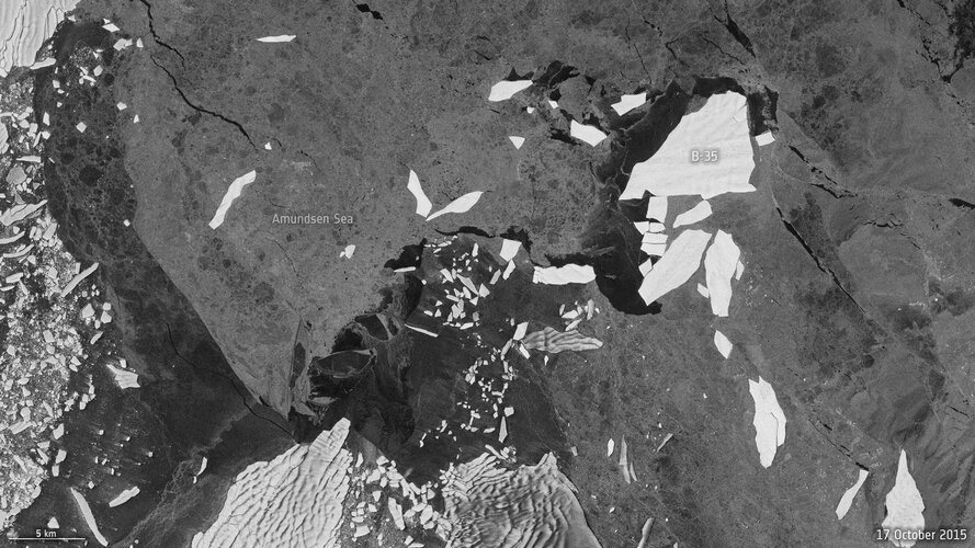
In a groundbreaking development, researchers from the University of Leeds have unveiled a neural network that can swiftly and accurately chart the expanse of large Antarctic icebergs in satellite images, accomplishing the task in a mere 0.01 seconds. This novel approach is in stark contrast to the laborious and time-consuming manual efforts needed previously.
OZNÁMENÍ O VYHLÁŠENÍ VÝBĚROVÉHO ŘÍZENÍ na služební místo rada/odborný rada – rozhodování o povolení
8.11.2023 15:20 ČÚZK - předpisy a opatření Katastrální úřad pro Olomoucký kraj Katastrální pracoviště Prostějovvypisuje výběrové řízení na místo
OZNÁMENÍ O VYHLÁŠENÍ VÝBĚROVÉHO ŘÍZENÍ na služební místo rada/odborný rada – rozhodování o povolení vkladu
OZNÁMENÍ O VYHLÁŠENÍ VÝBĚROVÉHO ŘÍZENÍ na služební místo rada/odborný rada – rozhodování o povolení
8.11.2023 15:20 ČÚZK /Urady/Katastralni-urady/Katastralni-urady/Katastralni-urad-pro-Olomoucky-kraj/Uredni-deska/Oznameni-a-jina-uredni-sdeleni/Volna-mista/DMS/OZNAMENI-O-VYHLASENI-VYBEROVEHO-RIZENI-na-sluzebniOZNÁMENÍ O VYHLÁŠENÍ VÝBĚROVÉHO ŘÍZENÍ na služební místo rada/odborný rada – rozhodování o povolení
8.11.2023 15:20 ČÚZK - volná místa Katastrální úřad pro Olomoucký kraj Katastrální pracoviště Prostějov vypisuje výběrové řízení na místo OZNÁMENÍ O VYHLÁŠENÍ VÝBĚROVÉHO ŘÍZENÍ na služební místo rada/odborný rada – rozhodování o povoleníSeminář 8. 11. 2023 - prezentace
8.11.2023 15:20 ČÚZK - předpisy a opatření Do záložky Prezentace byly přidány prezentace z odborného semináře k problematice zakládání, správy a aktualizace částí a rozsahů editace DTI v IS DMVS, který se konal dne 8. listopadu 2023 v Praze na ČÚZK.The openBIM for Electrical Engineering Activity Proposal has been reviewed and has been endorsed by the Standards Committee.
8.11.2023 15:10 buildingSMART.orgThe openBIM for Electrical Engineering Activity Proposal link has been reviewed and endorsed by the Standards Committee. The Standards Committee feedback and results can be viewed using the following link.
The post The openBIM for Electrical Engineering Activity Proposal has been reviewed and has been endorsed by the Standards Committee. appeared first on buildingSMART International.
The openBIM for Electrical Engineering Activity Proposal has been reviewed and has been endorsed by the Standards Committee.
8.11.2023 15:10 buildingSMART.orgThe openBIM for Electrical Engineering Activity Proposal “link” has been reviewed and endorsed by the Standards Committee. The Standards Committee feedback and results can be viewed using the following “link”.
The post The openBIM for Electrical Engineering Activity Proposal has been reviewed and has been endorsed by the Standards Committee. appeared first on buildingSMART International.
Nefunkční STAHUJ
8.11.2023 12:36 GEPROV poslední době se množí dotazy na dostupnost služby na stahování softwaru STAHUJ. Služba zatím stále ještě běží na starším protokolu HTTP. Některé prohlížeče však automaticky předpokládájí protokol HTTPS, na kterém služba ještě neběží. Prohlížeč proto oznámí, že hledaná stránka neexistuje. Pokud k této situaci dojde, zadejte do adresního řádku prohlížeče adresu http://stahuj.gepro.cz. Na změně protokolu …
Nefunkční STAHUJ Pokračovat ve čtení »
Článek Nefunkční STAHUJ se nejdříve objevil na GEPRO.
Dostupnost služby STAHUJ
8.11.2023 12:36 GEPROV poslední době se množí dotazy na dostupnost služby na stahování softwaru STAHUJ. Služba zatím stále ještě běží na starším protokolu HTTP. Některé prohlížeče však automaticky předpokládájí protokol HTTPS, na kterém služba ještě neběží. Prohlížeč proto oznámí, že hledaná stránka neexistuje. Pokud k této situaci dojde, zadejte do adresního řádku prohlížeče adresu http://stahuj.gepro.cz. Na změně protokolu […]
Článek Dostupnost služby STAHUJ se nejdříve objevil na GEPRO.
Dostupnost služby STAHUJ
8.11.2023 12:36 GEPROV poslední době se množí dotazy na dostupnost služby na stahování softwaru STAHUJ. Služba zatím stále ještě běží na starším protokolu HTTP. Některé prohlížeče však automaticky předpokládájí protokol HTTPS, na kterém služba ještě neběží. Prohlížeč proto oznámí, že hledaná stránka neexistuje. Pokud k této situaci dojde, zadejte do adresního řádku prohlížeče adresu http://stahuj.gepro.cz. Na změně protokolu …
Dostupnost služby STAHUJ Pokračovat ve čtení »
Článek Dostupnost služby STAHUJ se nejdříve objevil na GEPRO.
EU Space Week kicks off in Seville
7.11.2023 20:28 European GNSS Agency
Top EU policymakers, space industry actors and entrepreneurs from all walks of life convene in Sevilla, Spain to share knowledge and experiences on how businesses, governments, and society at large benefit from the EU Space Programme and its existing components, Galileo, EGNOS, Copernicus but also new ones such as GOVSATCOM and IRIS2.
Key themes in the 2023 edition of the conference are the use of space technology in our quest to become the first climate-neutral continent by 2050 and the importance of satellite services to shield Europe’s security and autonomy.
Autonomy and security for the Union
During the inaugural ceremony of the EU Space Week, Spanish Minister for Science and Innovation, Diana Morant, highlighted the crucial role of space in spurring innovation across all sectors of the economy: ‘’Space innovation plays a key role in solving some of our greatest challenges as a society, such as climate emergency. Space also ensures the autonomy of the Union and its Member States.’’
Director General for Defence Industry and Space at the European Commission, Timo Pesonen, reiterated the Union’s commitments to strengthening the resilience of its space infrastructures. “The space sector is undergoing a massive transformation. To maintain the leadership of Europe, we must rethink our resilience, our technological non-dependence and our business models. We need to consolidate and evolve our space assets.”
Eyes on 2035
During a roundtable discussion, top executives from the European Commission, EUSPA, the Spanish Space Agency and ESA shared their vision regarding the evolution of the EU Space Programme and the industry by 2035.
The Director of the Spanish Space Agency, Miguel Belló, said that Spain will continue contributing to the Programme by supporting future Copernicus missions and the upcoming satellite communications constellation IRIS2 and by working on developing more advanced surveillance systems which will be used for the European Space Surveillance and Tracking.
When asked what the key ingredient for the EU Space Programme is to be successful, Director-General for Defence Industry and Space, Timo Pesonen highlighted competitiveness. The Space sector is undergoing a massive transformation. To maintain the leadership of Europe, we must rethink our resilience, our technological non-dependence and business models,’’ he said
Present at the roundtable were EUSPA Executive Director, Rodrigo da Costa, and Director General of the European Space Agency Josef Aschbacher.
Staying true to the mission of the agency he leads, da Costa said that "adaptability is what will make the EU Space Programme and its various components evolve and deliver cutting edge space-based services. This can only be achieved through continuous dialogue with the users."
"Europe has realised the importance of the New Space economy which is projected to reach 1 trillion dollars by the year 2040. By 2035, I expect to see much bigger changes in the area of launchers among others," said Josef Aschbacher. ‘’Europe should develop innovative launchers able to carry various payloads he concluded.’’
New Space actors to the front!
As the global economy continues its multifaceted transformation, so does Europe’s space economy throughout its full value chain, upstream, midstream and downstream. A dedicated session called ‘’Interactive Discussion with Inspiring Entrepreneurs and Innovators’’ brought to the fore milestones achieved by the vibrant European New Space economy.
Space safety is becoming critical as the number of satellites in orbit grows exponentially. New space companies like Vyoma are now more and more contributing to the management of the space traffic caused either by debris or by functioning satellites. As Luisa Buinhas explained, Vyoma is looking to develop in-orbit optical telescopes to observe space objects and map the orbital environment at a high frequency, thus providing SSA data and services with near-zero latency.
In the area of micro-launchers, Europe made a significant leap with the launch of Miura-1 a suborbital launch vehicle, privately developed. As Raul Verdu explained "micro launchers in reshaping the European launchers industry but also are democratising access to space.’’
Orbify CEO Jakub Dziwisz praised the role of the CASSINI Business Accelerator and other EUSPA funding initiatives in giving start-ups the necessary tools to upscale. As Dziwisz explained his company automates the analysis of satellite imagery through AI and ML models to streamline the measurement and assessment of natural assets, providing environmental insights within a few clicks.
Another highlight of the day was an inspirational speech by Laia Romero, Co-founder and CEO of Lobelia Earth who emphasised the importance of Earth Observation in addressing climate change.
We’re just getting started!
EU Space Week day No2 is going to be a packed one so better get some rest!
Be sure to tune in tomorrow for an agenda that includes among others "New Ways of Doing Space’’, "Space 4 EU Green Deal’’ award ceremonies and networking events.
Could not make it to Spain? You can always participate online and network with other virtual participants through our interactive platform.
Media note: This feature can be republished without charge provided the European Union Agency for the Space Programme (EUSPA) is acknowledged as the source at the top or the bottom of the story. You must request permission before you use any of the photographs on the site. If you republish, we would be grateful if you could link back to the EUSPA website (http://www.euspa.europa.eu).
Domain Leaders’ Conference 16 January 2024
7.11.2023 15:10 buildingSMART.orgAll members of the Domain Steering Committees are invited to attend the next Domain Leaders’ Conference in Oslo. This will take place on the 16 – 17 January. The agenda…
The post Domain Leaders’ Conference 16 January 2024 appeared first on buildingSMART International.
Věcné úkoly Katastrálního úřadu pro Moravskoslezský kraj v roce 2023
7.11.2023 14:04 ČÚZK /Urady/Katastralni-urady/Katastralni-urady/Katastralni-urad-pro-Moravskoslezsky-kraj/O-uradu/Aktuality/Vecne-ukoly-Katastralniho-uradu-pro-MoravskoslezskVěcné úkoly Katastrálního úřadu pro Moravskoslezský kraj v roce 2023
7.11.2023 14:04 ČÚZK - předpisy a opatření Katastrální úřad pro Moravskoslezský kraj zveřejnil novou aktualitu: Seznam schválených věcných úkolů s plánovaným dokončením v roce 2023 (s uvedeným datem již dokončených VÚ).Vrchní referent / rada – vedení katastrální mapy v oddělení aktualizace KN Katastrálního pracoviště
7.11.2023 13:56 ČÚZK - předpisy a opatření Katastrální úřad pro Zlínský kraj Katastrální pracoviště Valašské Meziříčívypisuje výběrové řízení na místo
Vrchní referent / rada – vedení katastrální mapy v oddělení aktualizace KN Katastrálního pracoviště Valašské Meziříčí
Vrchní referent / rada – vedení katastrální mapy v oddělení aktualizace KN Katastrálního pracoviště
7.11.2023 13:56 ČÚZK - volná místa Katastrální úřad pro Zlínský kraj Katastrální pracoviště Valašské Meziříčí vypisuje výběrové řízení na místo Vrchní referent / rada – vedení katastrální mapy v oddělení aktualizace KN Katastrálního pracovištěOdborný rada - kontrolor
7.11.2023 11:34 ČÚZK /Urady/Katastralni-urady/Katastralni-urady/Katastralni-urad-pro-hlavni-mesto-Prahu/O-uradu/Aktuality/Odborny-rada-kontrolorOdborný rada - kontrolor
7.11.2023 11:34 ČÚZK - předpisy a opatření Katastrální úřad pro hlavní město Prahu zveřejnil novou aktualitu: Ředitelka úřadu vyhlašuje výběrové řízení na služební místo:Odborný rada - kontrolor
Odborný rada - kontrolor
7.11.2023 11:29 ČÚZK - předpisy a opatření Katastrální úřad pro hlavní město Prahuvypisuje výběrové řízení na místo
Odborný rada - kontrolor
Odborný rada - kontrolor
7.11.2023 11:29 ČÚZK - volná místa Katastrální úřad pro hlavní město Prahu vypisuje výběrové řízení na místo Odborný rada - kontrolorOdborný rada - kontrolor
7.11.2023 11:29 ČÚZK /Urady/Katastralni-urady/Katastralni-urady/Katastralni-urad-pro-hlavni-mesto-Prahu/Uredni-deska/Oznameni-a-jina-uredni-sdeleni/Volna-mista/Odborny-rada-kontrolorRada/odborný rada – revize katastrálního operátu
7.11.2023 11:20 ČÚZK /Urady/Katastralni-urady/Katastralni-urady/Katastralni-urad-pro-hlavni-mesto-Prahu/O-uradu/Aktuality/Rada-odborny-rada-–-revize-katastralniho-operatuRada/odborný rada – revize katastrálního operátu
7.11.2023 11:20 ČÚZK - předpisy a opatření Katastrální úřad pro hlavní město Prahu zveřejnil novou aktualitu: Ředitelka úřadu vyhlašuje výběrové řízení na služební místo:Rada/odborný rada – revize katastrálního operátu
Rada/odborný rada – revize katastrálního operátu
7.11.2023 11:16 ČÚZK - předpisy a opatření Katastrální úřad pro hlavní město Prahuvypisuje výběrové řízení na místo
Rada/odborný rada – revize katastrálního operátu
Rada/odborný rada – revize katastrálního operátu
7.11.2023 11:16 ČÚZK /Urady/Katastralni-urady/Katastralni-urady/Katastralni-urad-pro-hlavni-mesto-Prahu/Uredni-deska/Oznameni-a-jina-uredni-sdeleni/Volna-mista/Rada-odborny-rada-–-revize-katastralniho-operatuRada/odborný rada – revize katastrálního operátu
7.11.2023 11:16 ČÚZK - volná místa Katastrální úřad pro hlavní město Prahu vypisuje výběrové řízení na místo Rada/odborný rada – revize katastrálního operátuAktualizace předpokládaných termínů realizace
7.11.2023 11:00 ČÚZK - předpisy a opatření V záložce Předpokládané termíny realizace byl aktualizován schválený posun termínu zahájení pilotního provozu IS DTM krajů na 1. dubna 2024 a dokumenty Zahájení provozu Informačního systému DTM krajůAktualizace předpokládaných termínů realizace
7.11.2023 11:00 ČÚZK - předpisy a opatření V záložce Předpokládané termíny realizace byl aktualizován schválený posun termínu zahájení pilotního provozu IS DTM krajů na 1. dubna 2023 a dokumenty Zahájení provozu Informačního systému DTM krajůEUSPA launches first Secure SATCOM Market and User Technology Report
7.11.2023 9:12 European GNSS Agency
Thanks to such publications as the EO and GNSS Market Report, GNSS User Technology Report, EU Space for Green Transformation and the GNSS Investment Report, EUSPA has positioned itself as the leading provider of critical market intelligence.
The secure SATCOM Market and User Technology Report intends to build upon the growing investments made by the EU with forthcoming EU GOVSATCOM, which aims to provide secure and cost-efficient communication capabilities to security and safety critical missions and operations, and the recently launched IRIS² initiative that will further expand the EU space-based connectivity capabilities of the EU Space Programme.
“As the go-to-source for all things EU Space, EUSPA has a well-earned reputation for being a trusted provider of insightful information and expertise that policymakers, entrepreneurs and major corporations can rely on,” says EUSPA Executive Director Rodrigo da Costa.
Today, the Agency adds a new title to its already rich library of publications with the launch of the 1st Secure SATCOM Market and User Technology Report.
“The EU needs autonomous, secure, resilient and high-speed, space-based connectivity to satisfy the requirements of its institutions, bodies, agencies and Member States,” adds Fiammetta Diani, EUSPA Head of Market Downstream and Innovation. “Secure SATCOM answers this need by providing one or two-way resilient and guaranteed satellite capacity and services for communication purposes.”
The report is intended for such secure SATCOM users as governmental entities from Member States and EU agencies and organisations, as well as for small businesses and established enterprises willing to make investments into this strategic and fast-growing sector.
Greatest demand for secure SATCOM to come from key infrastructure
The Secure SATCOM Market and User Technology Report characterises users within the framework of 13 use cases organised into four categories:
- Surveillance (Land Border and Maritime)
- Crisis Management (Maritime Emergency, Humanitarian Aid, Civil Protection, Law Enforcement Interventions, EU External Actions and Forces Deployment)
- Key Infrastructure (Transport, Space, Institutional Communications and Other Critical infrastructures)
- One transversal specific use case focusing on secure Satellite Communications in Polar Regions.
According to the Report, the user demand for fixed satellite services (FSS) in the EU will increase by a factor of 14 between 2025 and 2040, reaching around 186 Gbps by 2040. In 2025, the FSS capacity demand for Crisis Management is expected to count for around half of all FSS capacity demand. The Report further estimates that the Key Infrastructure category is set to generate the highest level of demand by 2040, representing around 50% of total capacity demand. The two largest use cases within this segment are Institutional Communications and Other Critical Infrastructures. About two-thirds of the estimated FSS capacity demand will come from Europe and waters geographical area and will include the need for permanent operational missions and for backup communications, with an increasing need to guarantee additional resilience to communication networks. The demand forecasted for EU missions and operations in Middle East and Africa is the second geographical area for the FSS capacity demand. It is worth noting that the vast majority of demand in this region comes from three uses cases from the Crisis Management category: Humanitarian Aid, EU External Action and Forces Deployment.
User demand for secure SATCOM from mobile satellite services (MSS) is expected to increase from around 1.2 Gbps (2025) to 3.9 Gbps (2040), with the majority coming from the maritime surveillance use case.
Digital technologies responsible for transforming secure SATCOM
The Secure SATCOM Market and User Technology Report further discusses the various structural drivers that are transforming and increasing the volume of telecommunication capacity offered through satellite assets, which will also necessarily impact the capacity and services for secured connectivity.
According to the Report, digital technologies are at the heart of this transformation, alongside the use of multi-orbital solutions, higher frequency bands and other features. However, as with any technology, new space-based connectivity solutions can be subject to certain limits and/or require cycles of adoptions. Examples include the need to deploy new interoperable terminals either because the new networks make use of new frequency bands or because access to Non-Geostationary Orbit (NGSO) requires a fast-tracking antenna.
Changes ahead
The Report goes on to note that the introduction of new technologies and business models, as well as the advent of new entrants, is strongly impacting the market. To name a few examples, the deployment of NGSO Geostationary constellations will significantly increase the volume and diversity of capacity available. Furthermore, the organisations are moving toward a vertical integration and the market landscape is overall experiencing a consolidation bringing to life stronger and more competitive groups.
Other elements that could impact the use of secure SATCOM include geopolitical trends, climate change, economic growth or stagnation, the rise of the digital economy, national and international regulations and EU policy.
The Report further highlights the potential impact of the so-called New Space actors. “These companies bring innovative and cost-effective solutions at a high pace, enriching the market ecosystem which will have to be increasingly able to deliver secure and resilient SATCOM capabilities and products tailored to a variety of users” says Flavio Sbardellati, EUSPA Market Downstream and Innovation.
To learn more, be sure to download your free copy of EUSPA’s Secure SATCOM Market and User Technology Report today!
Media note: This feature can be republished without charge provided the European Union Agency for the Space Programme (EUSPA) is acknowledged as the source at the top or the bottom of the story. You must request permission before you use any of the photographs on the site. If you republish, we would be grateful if you could link back to the EUSPA website (http://www.euspa.europa.eu).
Návod pro zakládání částí a rozsahů DTI
6.11.2023 17:25 ČÚZK - předpisy a opatření Do záložky Portál DMVS byl vystaven dokument Zakládání částí DTI a rozsahů editace DTIUzavření dokumentace
6.11.2023 14:04 ČÚZK - předpisy a opatření Katastrální úřad pro Středočeský kraj - Katastrální pracoviště Rakovník zveřejnil novou aktualitu: Z personálních důvodů je DOKUMENTACE uzavřena, jednoduché informace poskytuje PODATELNA.Ostatní činnosti budou řešeny formou písemné objednávky.
Uzavření dokumentace
6.11.2023 14:04 ČÚZK /Urady/Katastralni-urady/Katastralni-urady/Katastralni-urad-pro-Stredocesky-kraj/Katastralni-pracoviste/KP-Rakovnik/O-uradu/Aktuality/Uzavreni-dokumentace20231106 - stavový VFR adres
6.11.2023 13:33 ČÚZK /ruian/Poskytovani-udaju-ISUI-RUIAN-VDP/Vymenny-format-RUIAN-(VFR)/Archiv-novinek-VFR/2023/20231106-stavovy-VFR-adres20231106 - stavový VFR adres
6.11.2023 13:33 ČÚZK /ruian/Poskytovani-udaju-ISUI-RUIAN-VDP/Vymenny-format-RUIAN-(VFR)/Archiv-novinek-VFR/2023/20231106-stavovy-VFR-adresESA and EC to unite on climate action from space
6.11.2023 12:00 ESA Observing the Earth
ESA and the European Commission are joining forces to accelerate the use of Earth-observing satellites and the information they provide to address the pressing challenge of climate change.
This landmark initiative signifies a firm commitment to advancing our understanding of Earth's climate system and enhancing our ability to take timely and informed actions to mitigate and adapt to the impacts of climate change, particularly encompassing the European Green Deal.