


![]()

zprávy
zdroje zpráv:2011
28.11.2023 13:26 ČÚZK /Urady/Zememericky-urad/Casto-hledane-informace/Poskytovani-informaci-106-1999-Sb/Vyrocni-zpravy-dle-zakona-c-106-1999-Sb/Vyrocni-zprava-ZU-dle-zakona-c-106-1999-Sb/2011Výroční zpráva dle zákona č. 106/1999 Sb. za rok 2018
28.11.2023 13:26 Zeměměřický úřad Zeměměřický úřadvydává výroční zprávu úřadu za rok
2018
Výroční zpráva dle zákona č. 106/1999 Sb. za rok 2018
28.11.2023 13:26 ČÚZK /Urady/Zememericky-urad/Casto-hledane-informace/Poskytovani-informaci-106-1999-Sb/Vyrocni-zpravy-dle-zakona-c-106-1999-Sb/Vyrocni-zprava-ZU-dle-zakona-c-106-1999-Sb/Vyrocni-zprava-dle-zakona-c-106-1999-Sb-za-rok-22002
28.11.2023 13:25 ČÚZK /Urady/Zememericky-urad/Casto-hledane-informace/Poskytovani-informaci-106-1999-Sb/Vyrocni-zpravy-dle-zakona-c-106-1999-Sb/Vyrocni-zprava-ZU-dle-zakona-c-106-1999-Sb/20022008
28.11.2023 13:25 ČÚZK /Urady/Zememericky-urad/Casto-hledane-informace/Poskytovani-informaci-106-1999-Sb/Vyrocni-zpravy-dle-zakona-c-106-1999-Sb/Vyrocni-zprava-ZU-dle-zakona-c-106-1999-Sb/20082009
28.11.2023 13:25 ČÚZK /Urady/Zememericky-urad/Casto-hledane-informace/Poskytovani-informaci-106-1999-Sb/Vyrocni-zpravy-dle-zakona-c-106-1999-Sb/Vyrocni-zprava-ZU-dle-zakona-c-106-1999-Sb/20092007
28.11.2023 13:25 ČÚZK /Urady/Zememericky-urad/Casto-hledane-informace/Poskytovani-informaci-106-1999-Sb/Vyrocni-zpravy-dle-zakona-c-106-1999-Sb/Vyrocni-zprava-ZU-dle-zakona-c-106-1999-Sb/20072003
28.11.2023 13:25 ČÚZK /Urady/Zememericky-urad/Casto-hledane-informace/Poskytovani-informaci-106-1999-Sb/Vyrocni-zpravy-dle-zakona-c-106-1999-Sb/Vyrocni-zprava-ZU-dle-zakona-c-106-1999-Sb/20032004
28.11.2023 13:25 ČÚZK /Urady/Zememericky-urad/Casto-hledane-informace/Poskytovani-informaci-106-1999-Sb/Vyrocni-zpravy-dle-zakona-c-106-1999-Sb/Vyrocni-zprava-ZU-dle-zakona-c-106-1999-Sb/20042006
28.11.2023 13:25 ČÚZK /Urady/Zememericky-urad/Casto-hledane-informace/Poskytovani-informaci-106-1999-Sb/Vyrocni-zpravy-dle-zakona-c-106-1999-Sb/Vyrocni-zprava-ZU-dle-zakona-c-106-1999-Sb/20062005
28.11.2023 13:25 ČÚZK /Urady/Zememericky-urad/Casto-hledane-informace/Poskytovani-informaci-106-1999-Sb/Vyrocni-zpravy-dle-zakona-c-106-1999-Sb/Vyrocni-zprava-ZU-dle-zakona-c-106-1999-Sb/200520231128_Rada / odborný rada právního oddělení
28.11.2023 13:22 ČÚZK - předpisy a opatření Katastrální úřad pro Středočeský kraj - Katastrální pracoviště Praha-západ Vyhlášení výběrového řízení: Rada / odborný rada právního oddělení V části "Úřední deska", v sekci "Oznámení a jiná úřední sdělení" bylo vystaveno "Oznámení o vyhlášení výběrového řízení na obsazení služebního místa Rada / odborný rada právního oddělení"20231128_Rada / odborný rada právního oddělení
28.11.2023 13:22 ČÚZK /Urady/Katastralni-urady/Katastralni-urady/Katastralni-urad-pro-Stredocesky-kraj/Katastralni-pracoviste/KP-Praha-zapad/O-uradu/Aktuality/20210922_Odborny-referent-oddeleni-aktualizac-(6)20231128_Vrchní referent / rada oddělení aktualizace GI KN 04413
28.11.2023 12:46 ČÚZK /Urady/Katastralni-urady/Katastralni-urady/Katastralni-urad-pro-Stredocesky-kraj/Katastralni-pracoviste/KP-Praha-zapad/O-uradu/Aktuality/20230910_Vrchni-referent-rada-oddeleni-aktuali-(3)20231128_Vrchní referent / rada oddělení aktualizace GI KN 04413
28.11.2023 12:46 ČÚZK - předpisy a opatření Katastrální úřad pro Středočeský kraj - Katastrální pracoviště Praha-západ Vyhlášení výběrového řízení: Vrchní referent / rada oddělení aktualizace GI KN Katastrálního pracoviště Praha – západ - 04413 V části "Úřední deska", v sekci "Oznámení a jiná úřední sdělení" bylo vystaveno "Oznámení o vyhlášení výběrového řízení na obsazení služebního místa Vrchní referent / rada oddělení aktualizace GI KN Katastrálního pracoviště Praha – západ - 04413"Vrchní referent / rada oddělení aktualizace GI KN 04413
28.11.2023 12:45 ČÚZK - volná místa Katastrální úřad pro Středočeský kraj Katastrální pracoviště Praha-západ vypisuje výběrové řízení na místo Vrchní referent / rada oddělení aktualizace GI KN 04413Vrchní referent / rada oddělení aktualizace GI KN 04413
28.11.2023 12:45 ČÚZK /Urady/Katastralni-urady/Katastralni-urady/Katastralni-urad-pro-Stredocesky-kraj/Uredni-deska/Oznameni-a-jina-uredni-sdeleni/Volna-mista/DMS/Vrchni-referent-rada-oddeleni-aktualizace-GI-K-(1)Vrchní referent / rada oddělení aktualizace GI KN 04413
28.11.2023 12:45 ČÚZK - předpisy a opatření Katastrální úřad pro Středočeský kraj Katastrální pracoviště Praha-západvypisuje výběrové řízení na místo
Vrchní referent / rada oddělení aktualizace GI KN 04413
20231128_Vrchní referent / rada oddělení aktualizace GI KN 04412
28.11.2023 12:24 ČÚZK /Urady/Katastralni-urady/Katastralni-urady/Katastralni-urad-pro-Stredocesky-kraj/Katastralni-pracoviste/KP-Praha-zapad/O-uradu/Aktuality/20230910_Vrchni-referent-rada-oddeleni-aktuali-(2)20231128_Vrchní referent / rada oddělení aktualizace GI KN 04412
28.11.2023 12:24 ČÚZK - předpisy a opatření Katastrální úřad pro Středočeský kraj - Katastrální pracoviště Praha-západ Vyhlášení výběrového řízení: Vrchní referent / rada oddělení aktualizace GI KN Katastrálního pracoviště Praha – západ - 04412 V části "Úřední deska", v sekci "Oznámení a jiná úřední sdělení" bylo vystaveno "Oznámení o vyhlášení výběrového řízení na obsazení služebního místa Vrchní referent / rada oddělení aktualizace GI KN Katastrálního pracoviště Praha – západ - 04412"Vrchní referent / rada oddělení aktualizace GI KN 04412
28.11.2023 12:23 ČÚZK /Urady/Katastralni-urady/Katastralni-urady/Katastralni-urad-pro-Stredocesky-kraj/Uredni-deska/Oznameni-a-jina-uredni-sdeleni/Volna-mista/DMS/Vrchni-referent-rada-oddeleni-aktualizace-GI-KN-04Vrchní referent / rada oddělení aktualizace GI KN 04412
28.11.2023 12:23 ČÚZK - předpisy a opatření Katastrální úřad pro Středočeský kraj Katastrální pracoviště Praha-západvypisuje výběrové řízení na místo
Vrchní referent / rada oddělení aktualizace GI KN 04412
Vrchní referent / rada oddělení aktualizace GI KN 04412
28.11.2023 12:23 ČÚZK - volná místa Katastrální úřad pro Středočeský kraj Katastrální pracoviště Praha-západ vypisuje výběrové řízení na místo Vrchní referent / rada oddělení aktualizace GI KN 0441220231128_Odborný / vrchní referent oddělení dokumentace KN
28.11.2023 11:19 ČÚZK - předpisy a opatření Katastrální úřad pro Středočeský kraj - Katastrální pracoviště Příbram Vyhlášení výběrového řízení: Odborný / vrchní referent oddělení dokumentace KN V části "Úřední deska", v sekci "Oznámení a jiná úřední sdělení" bylo vystaveno "Oznámení o vyhlášení výběrového řízení na obsazení služebního místa Odborný / vrchní referent oddělení dokumentace KN"20231128_Odborný / vrchní referent oddělení dokumentace KN
28.11.2023 11:19 ČÚZK /Urady/Katastralni-urady/Katastralni-urady/Katastralni-urad-pro-Stredocesky-kraj/Katastralni-pracoviste/KP-Pribram/O-uradu/Aktuality/20230910_Odborny-vrchni-referent-oddeleni-prav-(1)Odborný / vrchní referent oddělení dokumentace KN
28.11.2023 11:18 ČÚZK - předpisy a opatření Katastrální úřad pro Středočeský kraj Katastrální pracoviště Příbramvypisuje výběrové řízení na místo
Odborný / vrchní referent oddělení dokumentace KN
Odborný / vrchní referent oddělení dokumentace KN
28.11.2023 11:18 ČÚZK - volná místa Katastrální úřad pro Středočeský kraj Katastrální pracoviště Příbram vypisuje výběrové řízení na místo Odborný / vrchní referent oddělení dokumentace KN20231128_Odborný / vrchní referent oddělení obnovy katastrálního op. 03120 TS KÚ SČK, d.p.Příbram
28.11.2023 11:07 ČÚZK - předpisy a opatření Katastrální úřad pro Středočeský kraj Vyhlášení výběrového řízení: místa Odborný / vrchní referent oddělení obnovy katastrálního op. 03120 TS KÚ SČK, d.p.Příbram V části "Úřední deska", v sekci "Oznámení a jiná úřední sdělení" bylo vystaveno "Oznámení o vyhlášení výběrového řízení na obsazení služebního místa Odborný / vrchní referent oddělení obnovy katastrálního operátu 03120 TS KÚ SČK, detašované pracoviště Příbram"20231128_Odborný / vrchní referent oddělení obnovy katastrálního op. 03120 TS KÚ SČK, d.p.Příbram
28.11.2023 11:07 ČÚZK /Urady/Katastralni-urady/Katastralni-urady/Katastralni-urad-pro-Stredocesky-kraj/O-uradu/Aktuality/20230310_Odborny-vrchni-referent-oddeleni-obno-(2)Odborný / vrchní referent oddělení obnovy katastrálního operátu 03120 TS KÚ SČK, detašované pracoviš
28.11.2023 11:05 ČÚZK /Urady/Katastralni-urady/Katastralni-urady/Katastralni-urad-pro-Stredocesky-kraj/Uredni-deska/Oznameni-a-jina-uredni-sdeleni/Volna-mista/DMS/Odborny-vrchni-referent-oddeleni-obnovy-katastralnOdborný / vrchní referent oddělení obnovy katastrálního operátu 03120 TS KÚ SČK, detašované pracoviš
28.11.2023 11:05 ČÚZK - volná místa Katastrální úřad pro Středočeský kraj odbor obnovy - Katastrálního operátu vypisuje výběrové řízení na místo Odborný / vrchní referent oddělení obnovy katastrálního operátu 03120 TS KÚ SČK, detašované pracovišOdborný / vrchní referent oddělení obnovy katastrálního operátu 03120 TS KÚ SČK, detašované pracoviš
28.11.2023 11:05 ČÚZK - předpisy a opatření Katastrální úřad pro Středočeský kraj odbor obnovy - Katastrálního operátuvypisuje výběrové řízení na místo
Odborný / vrchní referent oddělení obnovy katastrálního operátu 03120 TS KÚ SČK, detašované pracoviště Příbram
Světový den půdy 2023 [Knihovna geografie, byTopic]
28.11.2023 10:10 Katedra aplikované geoinformatiky a kartografie Přf UK Světový den půdy, který nese název “Soil and Water: a source of life”, se uskuteční pod záštitou České geografické společnosti.Zkrácení otevírací doby [Knihovna geografie, byTopic]
28.11.2023 9:55 Katedra aplikované geoinformatiky a kartografie Přf UK ve středu 29. listopadu. Knihovna geografie bude otevřena pouze do 16:00.VŘ 600 - Rada/odborný rada – vedoucí oddělení právních vztahů k nemovitostem na KP Karviná.
28.11.2023 9:11 ČÚZK /Urady/Katastralni-urady/Katastralni-urady/Katastralni-urad-pro-Moravskoslezsky-kraj/Uredni-deska/Oznameni-a-jina-uredni-sdeleni/Volna-mista/DMS/VR-600-Rada-odborny-rada-–-vedouci-oddeleni-pravniVŘ 600 - Rada/odborný rada – vedoucí oddělení právních vztahů k nemovitostem na KP Karviná.
28.11.2023 9:11 ČÚZK - volná místa Katastrální úřad pro Moravskoslezský kraj Katastrální pracoviště Karviná vypisuje výběrové řízení na místo VŘ 600 - Rada/odborný rada – vedoucí oddělení právních vztahů k nemovitostem na KP Karviná.VŘ 600 - Rada/odborný rada – vedoucí oddělení právních vztahů k nemovitostem na KP Karviná.
28.11.2023 9:11 ČÚZK - předpisy a opatření Katastrální úřad pro Moravskoslezský kraj Katastrální pracoviště Karvinávypisuje výběrové řízení na místo
VŘ 600 - Rada/odborný rada – vedoucí oddělení právních vztahů k nemovitostem na KP Karviná.
Přerušení provozu DP a WSDP v pátek 1.12.2023 od 16:30 do cca 21:00, sbírka listin od pátku 1.12.202
28.11.2023 7:32 Dálkový přístup k údajům KN ČR Vážení uživatelé,oznamujeme, že v pátek 1.12.2023 od 16:30 bude z provozních důvodů zcela přerušen provoz Dálkového přístupu i Webových služeb dálkového přístupu. Obnovení provozu předpokládáme v cca 21 hodin. U této verze nedochází ke změnám webových služeb.
Poskytování dokumentů ze sbírky listin nebude pomocí Dálkového přístupu dostupné od pátku 1.12.2023 od 14:30 do soboty 2.12.2023 do cca 12:00.
Za komplikace tímto způsobené se omlouváme a děkujeme za pochopení.
Přerušení provozu DP a WSDP v pátek 1.12.2023 od 16:30 do cca 21:00, sbírka listin od pátku 1.12.202
28.11.2023 7:32 ČÚZK - předpisy a opatření Vážení uživatelé,oznamujeme, že v pátek 1.12.2023 od 16:30 bude z provozních důvodů zcela přerušen provoz Dálkového přístupu i Webových služeb dálkového přístupu. Obnovení provozu předpokládáme v cca 21 hodin. U této verze nedochází ke změnám webových služeb.
Poskytování dokumentů ze sbírky listin nebude pomocí Dálkového přístupu dostupné od pátku 1.12.2023 od 14:30 do soboty 2.12.2023 do cca 12:00.
Za komplikace tímto způsobené se omlouváme a děkujeme za pochopení.
Přerušení provozu DP a WSDP v pátek 1.12.2023 od 16:30 do cca 21:00, sbírka listin od pátku 1.12.202
28.11.2023 7:32 ČÚZK /Aplikace-DP-do-KN/Aplikace-DP-do-KN/Archiv-DP/401139Odborný referent/vrchní referent – poskytování informací a nahlížení do KN
27.11.2023 16:41 ČÚZK - předpisy a opatření Katastrální úřad pro hlavní město Prahu zveřejnil novou aktualitu: Ředitelka úřadu vyhlašuje výběrové řízení na služební místo:Odborný referent/vrchní referent – poskytování informací a nahlížení do KN
Odborný referent/vrchní referent – poskytování informací a nahlížení do KN
27.11.2023 16:41 ČÚZK /Urady/Katastralni-urady/Katastralni-urady/Katastralni-urad-pro-hlavni-mesto-Prahu/O-uradu/Aktuality/Odborny-referent-vrchni-referent-–-poskytovani-infOdborný referent/vrchní referent – poskytování informací a nahlížení do KN
27.11.2023 16:38 ČÚZK - předpisy a opatření Katastrální úřad pro hlavní město Prahuvypisuje výběrové řízení na místo
Odborný referent/vrchní referent – poskytování informací a nahlížení do KN
Odborný referent/vrchní referent – poskytování informací a nahlížení do KN
27.11.2023 16:38 ČÚZK - volná místa Katastrální úřad pro hlavní město Prahu vypisuje výběrové řízení na místo Odborný referent/vrchní referent – poskytování informací a nahlížení do KNOdborný referent/vrchní referent – poskytování informací a nahlížení do KN
27.11.2023 16:38 ČÚZK /Urady/Katastralni-urady/Katastralni-urady/Katastralni-urad-pro-hlavni-mesto-Prahu/Uredni-deska/Oznameni-a-jina-uredni-sdeleni/Volna-mista/Odborny-referent-vrchni-referent-–-poskytovani-(1)20231127 - volné místo - Rada/odborný rada v oddělení aktualizace a dokumentace KN KP Most
27.11.2023 14:57 ČÚZK - předpisy a opatření Katastrální úřad pro Ústecký kraj - Katastrální pracoviště Most zveřejnil novou aktualitu: Nabídka volného místa - Rada / odborný rada v oddělení aktualizace a dokumentace katastru nemovitostí KP Most20231127 - volné místo - Rada/odborný rada v oddělení aktualizace a dokumentace KN KP Most
27.11.2023 14:57 ČÚZK /Urady/Katastralni-urady/Katastralni-urady/Katastralni-urad-pro-Ustecky-kraj/Katastralni-pracoviste/KP-Most/O-uradu/Aktuality/20231127-volne-misto-Rada-odborny-rada-v-oddeleni-20231127 - volné místo - Rada/odborný rada v oddělení aktualizace a dokumentace KN KP Most
27.11.2023 14:54 ČÚZK - předpisy a opatření Katastrální úřad pro Ústecký kraj - Katastrální pracoviště Most zveřejnil novou aktualitu: Nabídka volného místa - Rada / odborný rada v oddělení aktualizace a dokumentace katastru nemovitostí KP Most20231127 - volné místo - Rada/odborný rada v oddělení aktualizace a dokumentace KN KP Most
27.11.2023 14:54 ČÚZK /Urady/Katastralni-urady/Katastralni-urady/Katastralni-urad-pro-Ustecky-kraj/O-uradu/Aktuality/20231127-volne-misto-Rada-odborny-rada-v-oddeleni-Rada / odborný rada v oddělení aktualizace a dokumentace katastru nemovitostí KP Most
27.11.2023 14:48 ČÚZK /Urady/Katastralni-urady/Katastralni-urady/Katastralni-urad-pro-Ustecky-kraj/Uredni-deska/Oznameni-a-jina-uredni-sdeleni/Volna-mista/DMS/Rada-odborny-rada-v-oddeleni-aktualizace-a-dokumenRada / odborný rada v oddělení aktualizace a dokumentace katastru nemovitostí KP Most
27.11.2023 14:48 ČÚZK - volná místa Katastrální úřad pro Ústecký kraj Katastrální pracoviště Most vypisuje výběrové řízení na místo Rada / odborný rada v oddělení aktualizace a dokumentace katastru nemovitostí KP MostRada / odborný rada v oddělení aktualizace a dokumentace katastru nemovitostí KP Most
27.11.2023 14:48 ČÚZK - předpisy a opatření Katastrální úřad pro Ústecký kraj Katastrální pracoviště Mostvypisuje výběrové řízení na místo
Rada / odborný rada v oddělení aktualizace a dokumentace katastru nemovitostí KP Most
20231127-VŘ KP Brno
27.11.2023 12:57 ČÚZK - aktuality v resortu Oznámení o vyhlášení výběrového řízení na obsazení služebního místa ředitele/ ředitelky Katastrálního pracoviště Brno-město.20231127-VŘ KP Brno
27.11.2023 12:57 ČÚZK - předpisy a opatření Český úřad zeměměřický a katastrální zveřejnil novou aktualitu: Oznámení o vyhlášení výběrového řízení na obsazení služebního místa ředitele/ ředitelky Katastrálního pracoviště Brno-město.Vrchní referent/rada v oddělení aktualizace GI KN na Katastrálním pracovišti Brno - město
27.11.2023 11:50 ČÚZK - volná místa Katastrální úřad pro Jihomoravský kraj Katastrální pracoviště Brno-město vypisuje výběrové řízení na místo Vrchní referent/rada v oddělení aktualizace GI KN na Katastrálním pracovišti Brno - městoVrchní referent/rada v oddělení aktualizace GI KN na Katastrálním pracovišti Brno - město
27.11.2023 11:50 ČÚZK /Urady/Katastralni-urady/Katastralni-urady/Katastralni-urad-pro-Jihomoravsky-kraj/Uredni-deska/Oznameni-a-jina-uredni-sdeleni/Volna-mista/DMS/Vrchni-referent-rada-v-oddeleni-aktualizace-GI-KN-Vrchní referent/rada v oddělení aktualizace GI KN na Katastrálním pracovišti Brno - město
27.11.2023 11:50 ČÚZK - předpisy a opatření Katastrální úřad pro Jihomoravský kraj Katastrální pracoviště Brno-městovypisuje výběrové řízení na místo
Vrchní referent/rada v oddělení aktualizace GI KN na Katastrálním pracovišti Brno - město
Pozvánka na školení z oborů CAD/CAM, strojírenství, výroba
27.11.2023 10:06 Arkance SystemsVyužijte novou nabídku kurzů Autodesk Fusion, AutoCAD a Inventor od společnosti ARKANCE. Povyšte vaše znalosti.
Zpráva Pozvánka na školení z oborů CAD/CAM, strojírenství, výroba pochází z arkance-systems.cz.
Nefunkční telefony
27.11.2023 8:33 ČÚZK - předpisy a opatření Katastrální úřad pro Středočeský kraj - Katastrální pracoviště Rakovníkzveřejnil novou aktualitu: Z důvodu instalace nové telefonní ústředny bude omezeno telefonní spojení s naším pracovištěm a to ve dnech 28.-29.11.2023!
Nefunkční telefony
27.11.2023 8:33 ČÚZK /Urady/Katastralni-urady/Katastralni-urady/Katastralni-urad-pro-Stredocesky-kraj/Katastralni-pracoviste/KP-Rakovnik/O-uradu/Aktuality/Nefunkcni-telefonyRada/odborný rada - ředitel/ka Katastrálního pracoviště Brno - město
27.11.2023 8:33 ČÚZK /Urady/Katastralni-urady/Katastralni-urady/Katastralni-urad-pro-Jihomoravsky-kraj/Uredni-deska/Oznameni-a-jina-uredni-sdeleni/Volna-mista/DMS/Rada-odborny-rada-reditel-ka-Katastralniho-pracoviRada/odborný rada - ředitel/ka Katastrálního pracoviště Brno - město
27.11.2023 8:33 ČÚZK - volná místa Katastrální úřad pro Jihomoravský kraj Katastrální pracoviště Brno-město vypisuje výběrové řízení na místo Rada/odborný rada - ředitel/ka Katastrálního pracoviště Brno - městoRada/odborný rada - ředitel/ka Katastrálního pracoviště Brno - město
27.11.2023 8:33 ČÚZK - předpisy a opatření Katastrální úřad pro Jihomoravský kraj Katastrální pracoviště Brno-městovypisuje výběrové řízení na místo
Rada/odborný rada - ředitel/ka Katastrálního pracoviště Brno - město
9. ročník UAV workshopu zaměřeného na použití dronů pro mapování lesních ekosystémů (pozvánka)
27.11.2023 8:11 GISportal.cz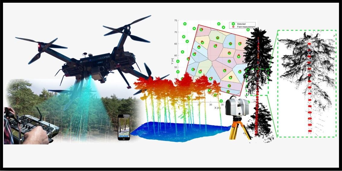
Katedra hospodářské úpravy lesů zve na 9. ročník UAV workshopu zaměřeného na použití dronů pro mapování lesních ekosystémů. Účast pro studenty je bezplatná. Přihlášení je možné na následujícím odkazu: https://www.uavforestry.cz/?page_id=630
The post 9. ročník UAV workshopu zaměřeného na použití dronů pro mapování lesních ekosystémů (pozvánka) appeared first on GISportal.cz.
Vrchní referent/rada – vedení katastrální mapy
27.11.2023 7:49 ČÚZK - volná místa Katastrální úřad pro Moravskoslezský kraj Katastrální pracoviště Ostrava vypisuje výběrové řízení na místo Vrchní referent/rada – vedení katastrální mapyVrchní referent/rada – vedení katastrální mapy
27.11.2023 7:49 ČÚZK - předpisy a opatření Katastrální úřad pro Moravskoslezský kraj Katastrální pracoviště Ostravavypisuje výběrové řízení na místo
Vrchní referent/rada – vedení katastrální mapy
Odstávka elektřiny v pondělí 27.11.2023
24.11.2023 19:12 ČÚZK /Urady/Katastralni-urady/Katastralni-urady/Katastralni-urad-pro-Moravskoslezsky-kraj/Katastralni-pracoviste/KP-Ostrava/O-uradu/Aktuality/Odstavka-elektriny-v pondeli-27-11-2023Odstávka elektřiny v pondělí 27.11.2023
24.11.2023 19:12 ČÚZK - předpisy a opatření Český úřad zeměměřický a katastrální zveřejnil novou aktualitu: Vážení klienti.Z důvodů odstávky elektřiny v pondělí 27.11.2023 od 8:00 do 9:00 nebude funkční informační systém katastru nemovitostí.
Příjem podání nebude v tomto čase omezen, platba bude možná pouze v hotovosti.
DAEX DESIGN Plus 24
24.11.2023 15:50 ŠPINAR - softwareNová verze DAEX DESIGN Professional 24 s akčními bonusy !
The post DAEX DESIGN Plus 24 appeared first on ŠPINAR – software.
DAEX DESIGN Plus 24
24.11.2023 15:50 ŠPINAR - software Nová verze DAEX DESIGN Professional 24 s akčními bonusy !Starý za nový Trimble TDC650
24.11.2023 13:39 GeotronicsJedinečná nabídka výměny pro všechny, kteří vlastní staré GPS přijímače Trimble.
The post Starý za nový Trimble TDC650 first appeared on GEOTRONICS Praha.
Starý za nový Trimble TDC650
24.11.2023 13:39 GeotronicsJedinečná nabídka výměny pro všechny, kteří vlastní staré GPS přijímače Trimble.
The post Starý za nový Trimble TDC650 first appeared on GEOTRONICS Praha.
Oznámení o vyhlášení výběrového řízení na doplňkové služební místo odborný referent / vrchní referen
24.11.2023 12:53 ČÚZK - předpisy a opatření Katastrální úřad pro Pardubický kraj Katastrální pracoviště Svitavyvypisuje výběrové řízení na místo
Oznámení o vyhlášení výběrového řízení na doplňkové služební místo odborný referent / vrchní referent v oddělení dokumentace katastru nemovitostí Katastrálního pracoviště Svitavy
Oznámení o vyhlášení výběrového řízení na doplňkové služební místo odborný referent / vrchní referen
24.11.2023 12:53 ČÚZK - volná místa Katastrální úřad pro Pardubický kraj Katastrální pracoviště Svitavy vypisuje výběrové řízení na místo Oznámení o vyhlášení výběrového řízení na doplňkové služební místo odborný referent / vrchní referenOznámení o vyhlášení výběrového řízení na doplňkové služební místo odborný referent / vrchní referen
24.11.2023 12:53 ČÚZK /Urady/Katastralni-urady/Katastralni-urady/Katastralni-urad-pro-Pardubicky-kraj/Uredni-deska/Oznameni-a-jina-uredni-sdeleni/Volna-mista/DMS/Oznameni-o-vyhlaseni-vyberoveho-rizeni-na-doplnkovOznámení o vyhlášení výběrového řízení na služební místo odborný referent / vrchní referent v odděle
24.11.2023 12:50 ČÚZK - volná místa Katastrální úřad pro Pardubický kraj Katastrální pracoviště Chrudim vypisuje výběrové řízení na místo Oznámení o vyhlášení výběrového řízení na služební místo odborný referent / vrchní referent v odděleOznámení o vyhlášení výběrového řízení na služební místo odborný referent / vrchní referent v odděle
24.11.2023 12:50 ČÚZK - předpisy a opatření Katastrální úřad pro Pardubický kraj Katastrální pracoviště Chrudimvypisuje výběrové řízení na místo
Oznámení o vyhlášení výběrového řízení na služební místo odborný referent / vrchní referent v oddělení aktualizace katastru nemovitostí Katastrálního pracoviště Chrudim
Oznámení o vyhlášení výběrového řízení na služební místo odborný referent / vrchní referent v odděle
24.11.2023 12:50 ČÚZK /Urady/Katastralni-urady/Katastralni-urady/Katastralni-urad-pro-Pardubicky-kraj/Uredni-deska/Oznameni-a-jina-uredni-sdeleni/Volna-mista/DMS/Oznameni-o-vyhlaseni-vyberoveho-rizeni-na-sluz-(1)Výstražná stávka 27.11.2023
24.11.2023 12:37 ČÚZK - předpisy a opatření Katastrální úřad pro Pardubický kraj - Katastrální pracoviště Chrudim zveřejnil novou aktualitu: Z důvodu připojení se k jednohodinové výstražné stávce vyhlášené Českomoravskou konfederací odborových svazů bude Katastrální pracoviště Chrudim dne 27.11.2023 v době od 12:00 do 13:00 uzavřeno. Veškerá podání je v této době možno vkládat do schránky v zádveří.Ing. Miroslav Kumstýř
Ředitel Katastrálního pracoviště Chrudim
Výstražná stávka 27.11.2023
24.11.2023 12:37 ČÚZK /Urady/Katastralni-urady/Katastralni-urady/Katastralni-urad-pro-Pardubicky-kraj/Katastralni-pracoviste/KP-Chrudim/O-uradu/Aktuality/Vystrazna-stavka-27-11-2023Výstražná stávka 27.11.2023
24.11.2023 12:37 ČÚZK - předpisy a opatření Katastrální úřad pro Pardubický kraj - Katastrální pracoviště Chrudim zveřejnil novou aktualitu: Z důvodu připojení se k jednohodinové výstražné stávce vyhlášené Českomoravskou konfederací odborových svazů bude Katastrální pracoviště Chrudim dne 27.11.2023 v době od 12:00 do 13:00 uzavřeno. Veškerá podání je v této době možno vkládat do schránky v zádveří.Ing. Miroslav Kumstýř
Ředitel Katastrálního pracoviště Chrudim
Výstražná stáva - leták
EGNOS and Galileo User Satisfaction Survey 2023 is open, and we want to hear from you!
24.11.2023 11:11 European GNSS Agency
Continuing from the combined survey model launched last year, this multiple-choice survey only takes a few minutes to complete but your contribution can have a huge impact on the future performance of EGNOS and Galileo.
"Through our User Satisfaction Survey 2023, we are empowering industries to shape the future of EGNOS and GALILEO. From assessing new features to gauging usefulness, every opinion counts,” recalled Carmen Aguilera, Operational Market Development Manager at EUSPA.
Market segment questions tailored to your industry
The survey is designed to tailor questions to suit you or your company by assessing specific market segments. Choose from one or multiple market segments such as maritime and inland waterways, surveying and mapping, location-based services (e.g. smartphones, IoT), agriculture, rail, and more. You will be then asked some simple questions based on your chosen market segments and you are done!
This year, the Galileo part of the survey also includes questions on satisfaction on the High Accuracy Service (HAS), a new service implemented in January 2023 and HAS and Open Service Navigation Message Authentication (OSNMA) reports. The EGNOS part of the survey covers all EGNOS services and the usefulness of notifications of outages and degradation. Current non-users are also welcome to take the survey and report their past experiences with compatibility or performance.
See how easy it is for yourself and take the User Satisfaction Survey 2023.
The deadline to answer is End of February 2024.
Results
The results of the survey will be compiled into a survey report and will be available in 2024.
Last year’s user performance report for EGNOS is now available. Galileo user reports (2022 report available soon) can be found here.
Media note: This feature can be republished without charge provided the European Union Agency for the Space Programme (EUSPA) is acknowledged as the source at the top or the bottom of the story. You must request permission before you use any of the photographs on the site. If you republish, we would be grateful if you could link back to the EUSPA website (http://www.euspa.europa.eu).
Earth from Space: Salty lakes
24.11.2023 10:00 ESA Observing the Earth Image:
The Copernicus Sentinel-2 mission captures the colourful waters of two salty lakes in East Africa: Lake Natron in northern Tanzania and Lake Magadi in southern Kenya.
Image:
The Copernicus Sentinel-2 mission captures the colourful waters of two salty lakes in East Africa: Lake Natron in northern Tanzania and Lake Magadi in southern Kenya.
Připojení ke stávce
24.11.2023 9:21 ČÚZK /Urady/Katastralni-urady/Katastralni-urady/Katastralni-urad-pro-Pardubicky-kraj/Katastralni-pracoviste/KP-Usti-nad-Orlici/O-uradu/Aktuality/Pripojeni-ke-stavcePřipojení ke stávce
24.11.2023 9:21 ČÚZK - předpisy a opatření Katastrální úřad pro Pardubický kraj - Katastrální pracoviště Ústí nad Orlicí zveřejnil novou aktualitu: Připojení k hodinové výstražné stávce Z důvodu připojení se k jednohodinové výstražné stávce proti konsolidačnímu balíčku vyhlášené Českomoravskou konfederací odborových svazů bude Katastrální pracoviště Ústí nad Orlicí dne 27.11.2023 v době od 12:00 do 13:00 uzavřeno. Veškerá podání je v této době možno vkládat do schránky ve vestibulu.Další informace naleznete v příloze.
Za případné komplikace se předem omlouváme.
Ing. Daniel Králík
Ředitel Katastrálního pracoviště Ústí nad Orlicí
Schválená dokumentace JVF DTM 1.4.3
23.11.2023 15:27 ZeměměřičČeský úřad zeměměřický a katastrální informoval, že dne 22. listopadu 2023 byla Koordinační radou správců DMVS a DTM schválena dokumentace k nové verzi JVF DTM 1.4.3. Oproti návrhu došlo v jednotlivých součástech k několika drobným úpravám, úřad tedy doporučuje vycházet ze schváleného stavu dokumentace. Dříve ČÚZK informoval, že s nasazením této verze dokumentace na produkční prostředí se počítá v průběhu prvního čtvrtletí roku 2024. […]
The post Schválená dokumentace JVF DTM 1.4.3 appeared first on Zeměměřič.
When Finance Manager met openBIM …
23.11.2023 12:44 buildingSMART.orgI’ve worked at buildingSMART for 9 years now and can say with some confidence that I’m pretty good at what I do. Don’t get me wrong, there’s always room for…
The post When Finance Manager met openBIM … appeared first on buildingSMART International.
When Finance Manager met openBIM…
23.11.2023 12:44 buildingSMART.orgI’ve worked at buildingSMART for 9 years now and can say with some confidence that I’m pretty good at what I do. Don’t get me wrong, there’s always room for…
The post When Finance Manager met openBIM… appeared first on buildingSMART International.
Spire joins ESA's Third Party Mission Programme
23.11.2023 11:54 ESA Observing the Earth
Spire joins ESA's Third Party Mission Programme
Schválená dokumentace JVF DTM 1.4.3
23.11.2023 10:40 ČÚZK - předpisy a opatření Český úřad zeměměřický a katastrální informuje, že dne 22. listopadu 2023 byla Koordinační radou správců DMVS a DTM schválena dokumentace k nové verzi JVF DTM 1.4.3. Oproti návrhu došlo v jednotlivých součástech k několika drobným úpravám, doporučujeme tedy vycházet ze schváleného stavu dokumentace, který je vystaven v záložce JVF DTM. Jak již bylo dříve uvedeno, s nasazením této verze na produkční prostředí se počítá v průběhu prvního čtvrtletí roku 2024, termín bude upřesněn.rada / odborný rada v oddělení právních vztahů k nemovitostem Katastrálního pracoviště Trutnov
23.11.2023 10:27 ČÚZK - volná místa Katastrální úřad pro Královéhradecký kraj Katastrální pracoviště Trutnov vypisuje výběrové řízení na místo rada / odborný rada v oddělení právních vztahů k nemovitostem Katastrálního pracoviště Trutnovrada / odborný rada v oddělení právních vztahů k nemovitostem Katastrálního pracoviště Trutnov
23.11.2023 10:27 ČÚZK - předpisy a opatření Katastrální úřad pro Královéhradecký kraj Katastrální pracoviště Trutnovvypisuje výběrové řízení na místo
rada / odborný rada v oddělení právních vztahů k nemovitostem Katastrálního pracoviště Trutnov
rada / odborný rada v oddělení právních vztahů k nemovitostem Katastrálního pracoviště Trutnov
23.11.2023 10:27 ČÚZK /Urady/Katastralni-urady/Katastralni-urady/Katastralni-urad-pro-Kralovehradecky-kraj/Uredni-deska/Oznameni-a-jina-uredni-sdeleni/Volna-mista/DMS/rada-odborny-rada-v-oddeleni-pravnich-vztahu-k-nemOdborný rada - právník v právním odd. VIII
22.11.2023 16:11 ČÚZK /Urady/Katastralni-urady/Katastralni-urady/Katastralni-urad-pro-hlavni-mesto-Prahu/O-uradu/Aktuality/Odborny-rada-pravnik-v-pravnim-odd-VIIIOdborný rada - právník v právním odd. VIII
22.11.2023 16:11 ČÚZK - předpisy a opatření Katastrální úřad pro hlavní město Prahu zveřejnil novou aktualitu: Ředitelka úřadu vyhlašuje výběrové řízení na služební místo:Odborný rada - právník v právním odd. VIII
Odborný rada - právník v právním odd. VIII
22.11.2023 16:08 ČÚZK - předpisy a opatření Katastrální úřad pro hlavní město Prahuvypisuje výběrové řízení na místo
Odborný rada - právník v právním odd. VIII
Odborný rada - právník v právním odd. VIII
22.11.2023 16:08 ČÚZK /Urady/Katastralni-urady/Katastralni-urady/Katastralni-urad-pro-hlavni-mesto-Prahu/Uredni-deska/Oznameni-a-jina-uredni-sdeleni/Volna-mista/Odborny-rada-pravnik-v-pravnim-odd-VIIIOdborný rada - právník v právním odd. VIII
22.11.2023 16:08 ČÚZK - volná místa Katastrální úřad pro hlavní město Prahu vypisuje výběrové řízení na místo Odborný rada - právník v právním odd. VIII
Krátka správa č. 52/2023
22.11.2023 11:26 Komora geodetů a kartografů SRThe post Krátka správa č. 52/2023 appeared first on Komora geodetov a kartografov.