


![]()

zprávy
zdroje zpráv:Krátka správa č. 45/2023
27.10.2023 15:20 Komora geodetů a kartografů SRThe post Krátka správa č. 45/2023 appeared first on Komora geodetov a kartografov.
Krátka správa č. 45/2023
27.10.2023 15:20 Komora geodetů a kartografů SRThe post Krátka správa č. 45/2023 appeared first on Komora geodetov a kartografov.
Watch live: ESA’s Earth Observation Commercialisation Forum
27.10.2023 13:45 ESA Observing the Earth
ESA’s first-ever Earth Observation Commercialisation Forum will take place next week at ESA Headquarters in Paris from 30 to 31 October 2023. The event will see investors, institutions, entrepreneurs and companies of any size from the Earth observation sector coming together to discuss the commercial potential and challenges of Earth observation. Follow our live steaming on ESA WebTV Two.
Dronedge 2024 – 9. ročník konference Aliance pro bezpilotní letecký průmysl
27.10.2023 10:09 UAVA Přijměte pozvání na letošní již 9. ročník konference Aliance pro bezpilotní letecký průmysl – Dronedge 2024. Datum: 11.9.2024 Místo: kino Dlabačov, Praha 6 Registrace bude spuštěnana přelomu červen/červenec 2024.Spolupořádali jsme Czechia-Korea Drone Roadshow a podepsali Memorandum s korejským KIAST
27.10.2023 10:09 UAVA Aliance byla spolupořadatelem a partnerem Czech Korea Drone Roadshow společně s Korejskou Trade Agency KOTRA, kde za velké účasti korejských i českých firem se konala v Praze B2B jednání a další konferenční program i za účasti českých autorit – ÚCL, ŘLP a Ministerstva dopravy. Současně podepsal prezident Aliance Memorandum o spolupráci s Korea Institute of […]Aktualizace služby WMTS ZABAGED® - polohopis
27.10.2023 10:01 ČÚZK - Geoportál Aktualizace služby WMTS ZABAGED® - polohopisProhlížecí služba z předpřipravených mapových dlaždic WMTS ZABAGED® - polohopis, vytvořená za účelem využití datové sady ZABAGED® - polohopis jako podkladové mapy s rychlým překreslováním, již poskytuje veškeré změny po poslední pravidelné čtvrtletní aktualizaci dat.
Již dříve (souběžně s aktualizací dat) byla aktualizována dynamická prohlížecí služba ZABAGED® - polohopis poskytující obraz dat přímo z publikační databáze, včetně možnosti vypínání vrstev, dotazů na atributy a stahování jednotlivých objektů ve formátu GeoJSON.
Pokud službu prohlížíte v našem Geoprohlížeči, je možné v seznamu vrstev přes menu "Možnosti" přejít na funkce stažení dat ZABAGED® - polohopis z celé ČR ve dvou souborových formátech a dvou souřadnicových systémech. Případně lze zvolit přípravu výřezu dat, který bude po krátkém zpracování nabídnut ke stažení v některém ze tří formátů a v souřadnicovém systému S-JTSK.
Aktualizace služby WMTS ZABAGED® - polohopis
27.10.2023 10:01 ČÚZK - Geoportál Aktualizace služby WMTS ZABAGED® - polohopisProhlížecí služba z předpřipravených mapových dlaždic WMTS ZABAGED® - polohopis, vytvořená za účelem využití datové sady ZABAGED® - polohopis jako podkladové mapy s rychlým překreslováním, již poskytuje veškeré změny po poslední pravidelné čtvrtletní aktualizaci dat.
Již dříve (souběžně s aktualizací dat) byla aktualizována dynamická prohlížecí služba ZABAGED® - polohopis poskytující obraz dat přímo z publikační databáze, včetně možnosti vypínání vrstev, dotazů na atributy a stahování jednotlivých objektů ve formátu GeoJSON.
Pokud službu prohlížíte v našem Geoprohlížeči, je možné v seznamu vrstev přes menu "Možnosti" přejít na funkce stažení dat ZABAGED® - polohopis z celé ČR ve dvou souborových formátech a dvou souřadnicových systémech. Případně lze zvolit přípravu výřezu dat, který bude po krátkém zpracování nabídnut ke stažení v některém ze tří formátů a v souřadnicovém systému S-JTSK.
Earth from Space: Elephant Island
27.10.2023 10:00 ESA Observing the Earth Image:
This rare, almost cloud-free view of the remote Elephant Island in Antarctica was captured in February 2023 by the Copernicus Sentinel-2 mission.
Image:
This rare, almost cloud-free view of the remote Elephant Island in Antarctica was captured in February 2023 by the Copernicus Sentinel-2 mission.
Aktualizace služby WMTS ZABAGED® - polohopis
27.10.2023 9:01 ČÚZK - Geoportál Aktualizace služby WMTS ZABAGED® - polohopisProhlížecí služba z předpřipravených mapových dlaždic WMTS ZABAGED® - polohopis, vytvořená za účelem využití datové sady ZABAGED® - polohopis jako podkladové mapy s rychlým překreslováním, již poskytuje veškeré změny po poslední pravidelné čtvrtletní aktualizaci dat.
Již dříve (souběžně s aktualizací dat) byla aktualizována dynamická prohlížecí služba ZABAGED® - polohopis poskytující obraz dat přímo z publikační databáze, včetně možnosti vypínání vrstev, dotazů na atributy a stahování jednotlivých objektů ve formátu GeoJSON.
Pokud službu prohlížíte v našem Geoprohlížeči, je možné v seznamu vrstev přes menu "Možnosti" přejít na funkce stažení dat ZABAGED® - polohopis z celé ČR ve dvou souborových formátech a dvou souřadnicových systémech. Případně lze zvolit přípravu výřezu dat, který bude po krátkém zpracování nabídnut ke stažení v některém ze tří formátů a v souřadnicovém systému S-JTSK.
Gearing up for EarthCARE
27.10.2023 9:00 ESA Observing the Earth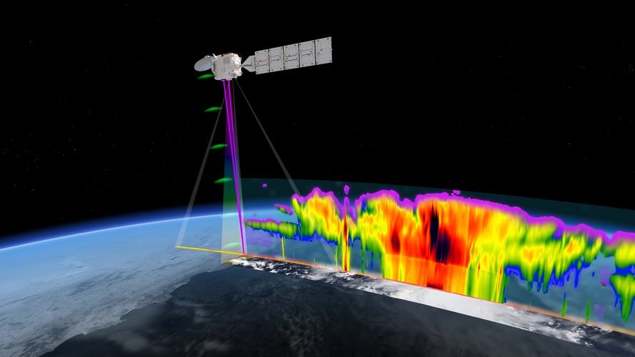
ESA and the Japanese Aerospace Exploration Agency are gearing up for a momentous milestone in Earth observation as launch of the EarthCARE satellite approaches.
Following years of rigorous development and extensive testing, the satellite is now undergoing its final round of tests in Europe before being shipped to the launch site early next year – bringing us one step closer to gaining unprecedented insights into the role that clouds and aerosols play in the climate system.
Spolupořádali jsme Czechia-Korea Drone Roadshow a podepsali Memorandum s korejským KIAST
27.10.2023 8:47 UAVAAliance byla spolupořadatelem a partnerem Czech Korea Drone Roadshow společně s Korejskou Trade Agency KOTRA, kde za velké účasti korejských i českých firem se konala v Praze B2B jednání a další konferenční program i za účasti českých autorit – ÚCL, ŘLP a Ministerstva dopravy. Současně podepsal prezident Aliance Memorandum o spolupráci s Korea Institute of […]
The post Spolupořádali jsme Czechia-Korea Drone Roadshow a podepsali Memorandum s korejským KIAST appeared first on UAV Aliance pro bezpilotní letecký průmysl.
Zajímavá konference s názvem „Mapy jsou pro každého 2023“ proběhla na Vysočině
27.10.2023 7:17 TopGisTradičně jsme zúčastnili jako hlavní partner již devátého ročníku konference s názvem "Mapy jsou pro každého 2023", která se uskutečnila od 12. do 13. září 2023 na Vysočině. Program konference se letos logicky hodně zaměřoval na právě dokončované projekty Digitální technické mapy krajů a na praktické zkušenosti realizátorů. Shlédli jsme ale i zajímavé příspěvky ...
Článek Zajímavá konference s názvem „Mapy jsou pro každého 2023“ proběhla na Vysočině se nejdříve objevil na TopGis, s.r.o..
Mapy jsou pro každého 2023
27.10.2023 7:17 TopGisTradičně jsme zúčastnili jako hlavní partner již devátého ročníku konference s názvem "Mapy jsou pro každého 2023", která se uskutečnila od 12. do 13. září 2023 na Vysočině. Program konference se letos logicky hodně zaměřoval na právě dokončované projekty Digitální technické mapy krajů a na praktické zkušenosti realizátorů. Shlédli jsme ale i zajímavé příspěvky ...
Článek Mapy jsou pro každého 2023 se nejdříve objevil na TopGis, s.r.o..
odborný referent - zápisy v řízení V a Z v oddělení právních vztahů k nemovitostem Katastrálního pra
26.10.2023 11:41 ČÚZK - volná místa Katastrální úřad pro Jihočeský kraj Katastrální pracoviště Jindřichův Hradec vypisuje výběrové řízení na místo odborný referent - zápisy v řízení V a Z v oddělení právních vztahů k nemovitostem Katastrálního praodborný referent - zápisy v řízení V a Z v oddělení právních vztahů k nemovitostem Katastrálního pra
26.10.2023 11:41 ČÚZK - předpisy a opatření Katastrální úřad pro Jihočeský kraj Katastrální pracoviště Jindřichův Hradecvypisuje výběrové řízení na místo
odborný referent - zápisy v řízení V a Z v oddělení právních vztahů k nemovitostem Katastrálního pracoviště Jindřichův Hradec (ID SM 30000192/30003816)
Six trends to watch in commercial Earth observation
26.10.2023 11:20 ESA Observing the Earth
With a multitude of opportunities for start-ups, established companies and investors, commercial Earth observation is a vibrant sector with fast-moving innovations in technology, datasets and downstream applications. ESA is a key driving force for the development of European Earth observation and provides impetus through its many programmes and initiatives.
To set the scene ahead of ESA’s Earth Observation Commercialisation Forum next week, here is some need-to-know background information on the evolution and state of play of the Earth observation industry.
Rada /odborný rada v oddělení právním č.1 na Katastrálním pracovišti Brno - město
26.10.2023 10:42 ČÚZK /Urady/Katastralni-urady/Katastralni-urady/Katastralni-urad-pro-Jihomoravsky-kraj/Uredni-deska/Oznameni-a-jina-uredni-sdeleni/Volna-mista/DMS/Rada-odborny-rada-v-oddeleni-pravnim-c-1-na-KatastRada /odborný rada v oddělení právním č.1 na Katastrálním pracovišti Brno - město
26.10.2023 10:42 ČÚZK - volná místa Katastrální úřad pro Jihomoravský kraj Katastrální pracoviště Brno-město vypisuje výběrové řízení na místo Rada /odborný rada v oddělení právním č.1 na Katastrálním pracovišti Brno - městoRada /odborný rada v oddělení právním č.1 na Katastrálním pracovišti Brno - město
26.10.2023 10:42 ČÚZK - předpisy a opatření Katastrální úřad pro Jihomoravský kraj Katastrální pracoviště Brno-městovypisuje výběrové řízení na místo
Rada /odborný rada v oddělení právním č.1 na Katastrálním pracovišti Brno - město
Spolupořádali jsme Czechia-Korea Drone Roadshow a podepsali Memorandum s korejským KIAST
26.10.2023 8:56 UAVA Aliance byla spolupořadatelem a partnerem Czech Korea Drone Roadshow společně s Korejskou Trade Agency KOTRA, kde za velké účasti korejských i českých firem (přes 30) se konala v Praze B2B jednání a konference, včetně účasti českých autorit Ministerstva dopravy, Úřadu pro civilní letectví a Řízení letového provozu. Prezident Aliance současně podepsal Memorandum o spolupráci s […]231026_Výběrové řízení_ředitel/ředitelka KP Brno-venkov
26.10.2023 8:55 ČÚZK - předpisy a opatření Český úřad zeměměřický a katastrální zveřejnil novou aktualitu: Oznámení o vyhlášení výběrového řízení na obsazení služebního místa ředitele/ ředitelky Katastrálního pracoviště Brno-venkov.231026_Výběrové řízení_ředitel/ředitelka KP Brno-venkov
26.10.2023 8:55 ČÚZK /Aktuality-resort/2023/231026_Vyberove-rizeni_reditel-reditelka-KP-Brno-v231026_Výběrové řízení_ředitel/ředitelka KP Brno-venkov
26.10.2023 8:55 ČÚZK - aktuality v resortu Oznámení o vyhlášení výběrového řízení na obsazení služebního místa ředitele/ ředitelky Katastrálního pracoviště Brno-venkov.Spolupořádali jsme Czechia-Korea Drone Roadshow a podepsali Memorandum o spolupráci s korejským KIAST
26.10.2023 8:47 UAVAAliance byla spolupořadatelem a partnerem Czech Korea Drone Roadshow společně s Korejskou Trade Agency KOTRA, kde za velké účasti korejských i českých firem se konala v Praze B2B jednání a další konferenční program i za účasti českých autorit – ÚCL, ŘLP a Ministerstva dopravy. Současně podepsal prezident Aliance Memorandum o spolupráci s Korea Institute of […]
The post Spolupořádali jsme Czechia-Korea Drone Roadshow a podepsali Memorandum o spolupráci s korejským KIAST appeared first on UAV Aliance pro bezpilotní letecký průmysl.
Výběrové řízení ředitel/ka KP Brno-venkov
26.10.2023 8:35 ČÚZK - předpisy a opatření Katastrální úřad pro Jihomoravský kraj zveřejnil novou aktualitu: Oznámení o vyhlášení výběrového řízení na služební místo rada / odborný rada – ředitel/ka Katastrálního pracoviště Brno-venkovVýběrové řízení ředitel/ka KP Brno-venkov
26.10.2023 8:35 ČÚZK /Urady/Katastralni-urady/Katastralni-urady/Katastralni-urad-pro-Jihomoravsky-kraj/O-uradu/Aktuality/Vyberove-rizeni-reditel-ka-KP-Brno-venkovNovinka: Jan Kryštof Müller: Barokní kartograf [Knihovna geografie, byTopic]
26.10.2023 8:20 Katedra aplikované geoinformatiky a kartografie Přf UK Historický ústav Akademie věd ČR vydává ve spolupráci s nakladatelstvím Academia novou knihuRada/odborný rada - ředitel/ka Katastrálního pracoviště Brno - venkov
26.10.2023 8:17 ČÚZK /Urady/Katastralni-urady/Katastralni-urady/Katastralni-urad-pro-Jihomoravsky-kraj/Uredni-deska/Oznameni-a-jina-uredni-sdeleni/Volna-mista/DMS/Rada-odborny-rada-reditel-ka-Katastralniho-pracoviRada/odborný rada - ředitel/ka Katastrálního pracoviště Brno - venkov
26.10.2023 8:17 ČÚZK - předpisy a opatření Katastrální úřad pro Jihomoravský kraj Katastrální pracoviště Brno-venkovvypisuje výběrové řízení na místo
Rada/odborný rada - ředitel/ka Katastrálního pracoviště Brno - venkov
Rada/odborný rada - ředitel/ka Katastrálního pracoviště Brno - venkov
26.10.2023 8:17 ČÚZK - volná místa Katastrální úřad pro Jihomoravský kraj Katastrální pracoviště Brno-venkov vypisuje výběrové řízení na místo Rada/odborný rada - ředitel/ka Katastrálního pracoviště Brno - venkovZveme do Brna na přednášku „Narrating about people and lands: maps, images, and text in early modern European book culture“
25.10.2023 23:06 Česká kartografická společnostJak byl v předmoderní době mapován, popisován a zobrazován prostor? A proč je zavádějící oddělovat kartografickou, obrazovou a slovní výpověď, když se snažíme dobrat odpovědi na uvedenou otázku studiem tzv. obrazových topografií? Na toto téma budou 27. října 2023 v Brně na Masarykově univerzitě hovořit v rámci společné přednášky Eva Chodějovská (Moravská zemská knihovna/Masarykova univerzita […]
The post Zveme do Brna na přednášku „Narrating about people and lands: maps, images, and text in early modern European book culture“ first appeared on Česká kartografická společnost.
UCP 2023: 8 industries meet to discuss Earth Observation, GNSS and Satcom trends and developments
25.10.2023 17:18 European GNSS Agency
End users are the core of the EU Space Programme which is why the EU Space Week features a set of industry focused sessions, the User Consultation Platform.
The User Consultation Platform (UCP) is a periodic forum organised by the European Commission (EC) and the European Union Agency for the Space Programme (EUSPA), where users from different market segments meet to discuss their needs for applications, services and data relying on Position, Navigation and Time (PNT), Earth observation and secure governmental communications.
The event involves end users, user associations and representatives of the value chain, such as receiver and chipset manufacturers, application developers and end users. It also gathers organisations and institutions dealing, directly and indirectly, with the European Global Navigation Satellite System (EGNSS), encompassing Galileo and EGNOS, the EU Earth Observation system, Copernicus, and with GOVSATCOM, the upcoming system for secure governmental communications. The UCP event is a part of the process developed at EUSPA to collect user needs and requirements and take them as inputs for the provision of user driven space data-based services by the EU Space Programme.
Check this out: EUSPA Releases User Consultation Platform 2022 Reports
The input collected from UCP does not stay in Sevilla but feeds the EU Space Programme: results are compiled in a set of reports that helps policymakers at DG DEFIS market development professionals and satellite engineers at EUSPA, evaluate the current and potential future user needs and requirements to improve existing or introduce new services based on Galileo, EGNOS, Copernicus and GOVSATCOM/IRIS2.
"The UCP is one of the most important events for us at EUSPA as it’s a platform where the real beneficiaries of the EU Space Programme gather to analyse their needs, reflect and debate" says EUSPA’s Fiammetta Diani, Head of Market, Downstream & Innovation. "The feedback from stakeholders in rail, agriculture, forestry, maritime just to name a few, is what makes the satellite services evolve. I look forward to meeting you all in Sevilla" she concluded.
Enrol in your preferred User Consultation Platform session here
8 sessions, 8 different sectors
Agriculture and forestry, rail and public transport and road and automotive are just some of the sessions where relevant stakeholders will confer about how Earth Observation, satellite navigation and satellite communications their sectors more sustainable, secured and efficient.
For the first time, and with its new role there will be a dedicated session Space Surveillance and Tracking (SST). This session focuses on the evolution of the EU SST capability and its services. Users will be consulted on their views on a proposal of advanced services complementary to the existing EU SST services, which may be developed by the EU industry. To stimulate the discussion there will be a roundtable with spacecraft operators representing all orbital regimes.
Register here and help shape the future of the EU Space Programme.
Media note: This feature can be republished without charge provided the European Union Agency for the Space Programme (EUSPA) is acknowledged as the source at the top or the bottom of the story. You must request permission before you use any of the photographs on the site. If you republish, we would be grateful if you could link back to the EUSPA website (http://www.euspa.europa.eu).
30. slovenské geodetické dni v Žiline
25.10.2023 17:05
ÚGKK SR
V sekcii Kataster nehnuteľností - Aktuality je zverejnená prezentácia predsedu ÚGKK SR na 30. SGD o aktuálnych informáciách z rezortu GKK v Žiline
vrchní referent/rada - kontrola listin určených k záznamu v oddělení právních vztahů k nemovitostem
25.10.2023 11:58 ČÚZK /Urady/Katastralni-urady/Katastralni-urady/Katastralni-urad-pro-Jihocesky-kraj/Uredni-deska/Oznameni-a-jina-uredni-sdeleni/Volna-mista/DMS/vrchni-referent-rada-kontrola-listin-urcenych-k-zavrchní referent/rada - kontrola listin určených k záznamu v oddělení právních vztahů k nemovitostem
25.10.2023 11:58 ČÚZK - volná místa Katastrální úřad pro Jihočeský kraj Katastrální pracoviště Strakonice vypisuje výběrové řízení na místo vrchní referent/rada - kontrola listin určených k záznamu v oddělení právních vztahů k nemovitostemvrchní referent/rada - kontrola listin určených k záznamu v oddělení právních vztahů k nemovitostem
25.10.2023 11:58 ČÚZK - předpisy a opatření Katastrální úřad pro Jihočeský kraj Katastrální pracoviště Strakonicevypisuje výběrové řízení na místo
vrchní referent/rada - kontrola listin určených k záznamu v oddělení právních vztahů k nemovitostem Katastrálního pracoviště Strakonice (ID SM 30000282/30003906)
Výběrové řízení
25.10.2023 11:55 ČÚZK - předpisy a opatření Katastrální úřad pro Plzeňský kraj - Katastrální pracoviště Tachov zveřejnil novou aktualitu: Ředitelka Katastrálního úřadu pro Plzeňský kraj jako služební orgán příslušný podle § 10 odst. 1 písm. f) zákona č. 234/2014 Sb., o státní službě, ve znění pozdějších předpisů, vyhlašuje výběrové řízení na služební místo odborný/vrchní referent – správa dokumentace katastru SDK1501, oddělení aktualizace a dokumentace KN, na Katastrálním úřadu pro Plzeňský kraj, na Katastrálním pracovišti Tachov, se služebním působištěm v Tachově.Na služebním místě je státní služba (dále jen „služba“) vykonávána v oboru služby 55. Zeměměřičství a katastr nemovitostí.
Služební místo je zařazeno podle přílohy č. 1 k zákonu o státní službě do 9. platové třídy.
Služba na služebním místě bude vykonávána ve služebním poměru na dobu neurčitou.
Předpokládaným dnem nástupu do služby na služebním místě je 1. leden 2024 nebo dohodou.
Délka stanovené týdenní služební doby je 40 hodin.
Na služebním místě se umožňuje služba se zkrácenou služební dobou („kratší úvazek“).
Výběrové řízení na služební místo odborný/vrchní referent - aktualizace a dokumentace KN
25.10.2023 11:49 ČÚZK - předpisy a opatření Katastrální úřad pro Plzeňský kraj Katastrální pracoviště Tachovvypisuje výběrové řízení na místo
Výběrové řízení na služební místo odborný/vrchní referent - aktualizace a dokumentace KN
Výběrové řízení na služební místo odborný/vrchní referent - aktualizace a dokumentace KN
25.10.2023 11:49 ČÚZK /Urady/Katastralni-urady/Katastralni-urady/Katastralni-urad-pro-Plzensky-kraj/Uredni-deska/Oznameni-a-jina-uredni-sdeleni/Volna-mista/DMS/Vyberove-rizeni-na-sluzebni-misto-odborny-vrchni-rVýběrové řízení na služební místo odborný/vrchní referent - aktualizace a dokumentace KN
25.10.2023 11:49 ČÚZK - volná místa Katastrální úřad pro Plzeňský kraj Katastrální pracoviště Tachov vypisuje výběrové řízení na místo Výběrové řízení na služební místo odborný/vrchní referent - aktualizace a dokumentace KNRada/odborný rada v oddělení aktualizace a dokumentace KN na Katastrálním pracovišti Blansko
25.10.2023 11:49 ČÚZK /Urady/Katastralni-urady/Katastralni-urady/Katastralni-urad-pro-Jihomoravsky-kraj/Uredni-deska/Oznameni-a-jina-uredni-sdeleni/Volna-mista/DMS/Rada-odborny-rada-v-oddeleni-aktualizace-a-dokumenRada/odborný rada v oddělení aktualizace a dokumentace KN na Katastrálním pracovišti Blansko
25.10.2023 11:49 ČÚZK - předpisy a opatření Katastrální úřad pro Jihomoravský kraj Katastrální pracoviště Blanskovypisuje výběrové řízení na místo
Rada/odborný rada v oddělení aktualizace a dokumentace KN na Katastrálním pracovišti Blansko
Rada/odborný rada v oddělení aktualizace a dokumentace KN na Katastrálním pracovišti Blansko
25.10.2023 11:49 ČÚZK - volná místa Katastrální úřad pro Jihomoravský kraj Katastrální pracoviště Blansko vypisuje výběrové řízení na místo Rada/odborný rada v oddělení aktualizace a dokumentace KN na Katastrálním pracovišti BlanskoPřerušení provozu DP a WSDP v pátek 27.10.2023 od 18:00 do cca 20:00.
25.10.2023 6:38 Dálkový přístup k údajům KN ČR Vážení uživatelé,oznamujeme, že v pátek 27.10.2023 od 18:00 bude z provozních důvodů zcela přerušen provoz Dálkového přístupu i Webových služeb dálkového přístupu. Obnovení provozu předpokládáme v cca 20 hodin. U této verze nedochází ke změnám webových služeb.
Za komplikace tímto způsobené se omlouváme a děkujeme za pochopení.
Přerušení provozu DP a WSDP v pátek 27.10.2023 od 18:00 do cca 20:00.
25.10.2023 6:38 ČÚZK - předpisy a opatření Vážení uživatelé,oznamujeme, že v pátek 27.10.2023 od 18:00 bude z provozních důvodů zcela přerušen provoz Dálkového přístupu i Webových služeb dálkového přístupu. Obnovení provozu předpokládáme v cca 20 hodin. U této verze nedochází ke změnám webových služeb.
Za komplikace tímto způsobené se omlouváme a děkujeme za pochopení.
Přerušení provozu DP a WSDP v pátek 27.10.2023 od 18:00 do cca 20:00.
25.10.2023 6:38 ČÚZK /Aplikace-DP-do-KN/Aplikace-DP-do-KN/Archiv-DP/398610Datový předpis C3 pro záborové elaboráty ŘSD má novou verzi, která začne platit od ledna 2024
25.10.2023 2:00 ZeměměřičIng. Kamil Alferi z Ředitelství silnic a dálnic redakci Zeměměřiče informoval, že dne 22. října 2023 byla podepsána nová verze Datového předpisu C3 – záborové elaboráty ŘSD ČR s účinností od 1. ledna 2024. Aktuální znění datového předpisu můžete stáhnout z webu ŘSD (Technické dokumenty – Datové předpisy). C3 – Datový předpis pro tvorbu digitálního záborového elaborátu pro ŘSD ČR (účinnost […]
The post Datový předpis C3 pro záborové elaboráty ŘSD má novou verzi, která začne platit od ledna 2024 appeared first on Zeměměřič.
Datový předpis C3 pro záborové elaboráty ŘSD má novou verzi, která začne platit od ledna 2024
25.10.2023 2:00 ZeměměřičIng. Kamil Alferi z Ředitelství silnic a dálnic redakci Zeměměřiče informoval, že dne 22. října 2023 byla podepsána nová verze Datového předpisu C3 – záborové elaboráty ŘSD ČR s účinností od 1. ledna 2024. Aktuální znění datového předpisu můžete stáhnout z webu ŘSD (Technické dokumenty -> Datové předpisy). C3 – Datový předpis pro tvorbu digitálního záborového elaborátu pro ŘSD ČR (účinnost […]
The post Datový předpis C3 pro záborové elaboráty ŘSD má novou verzi, která začne platit od ledna 2024 appeared first on Zeměměřič.
Hackathon 2023
24.10.2023 17:46 Katedra geoinformatiky UP Olomouc Přes víkend naše katedra spolupořádala výjimečnou událost Když data promluví – HACKATHON 2023 ❗️Této kreativní události, kde se celkem 8 různorodých týmů pokoušelo vymyslet, realizovat a prodat své inovativní projekty se účastnilo 35 soutěžících Mezi všemi vysoce kvalitními výstupy se nakonec podařilo zvítězit týmu UrbanMinds s projektem „Kde Olomouc vzkvétá a proč?“, který přímo postupuje […]Hackathon 2023
24.10.2023 17:46 Katedra geoinformatiky UP Olomouc Přes víkend naše katedra spolupořádala výjimečnou událost Když data promluví – HACKATHON 2023 ❗️Této kreativní události, kde se celkem 8 různorodých týmů pokoušelo vymyslet, realizovat a prodat své inovativní projekty se účastnilo 35 soutěžících Mezi všemi vysoce kvalitními výstupy se nakonec podařilo zvítězit týmu UrbanMinds s projektem „Kde Olomouc vzkvétá a proč?“, který přímo postupuje […]Hackathon 2023
24.10.2023 17:46 Katedra geoinformatiky UP OlomoucPřes víkend naše katedra spolupořádala výjimečnou událost Když data promluví – HACKATHON 2023 ❗️Této kreativní události, kde se celkem 8 různorodých týmů pokoušelo vymyslet, realizovat a prodat své inovativní projekty se účastnilo 35 soutěžících Mezi všemi vysoce kvalitními výstupy se nakonec podařilo zvítězit týmu UrbanMinds s projektem „Kde Olomouc vzkvétá a proč?“, který přímo postupuje […]
The post Hackathon 2023 first appeared on Katedra geoinformatiky.
Hackathon 2023
24.10.2023 17:46 Katedra geoinformatiky UP OlomoucPřes víkend naše katedra spolupořádala výjimečnou událost Když data promluví – HACKATHON 2023 ❗️Této kreativní události, kde se celkem 8 různorodých týmů pokoušelo vymyslet, realizovat a prodat své inovativní projekty se účastnilo 35 soutěžících Mezi všemi vysoce kvalitními výstupy se nakonec podařilo zvítězit týmu UrbanMinds s projektem „Kde Olomouc vzkvétá a proč?“, který přímo postupuje […]
The post Hackathon 2023 appeared first on Katedra geoinformatiky.
Výběrové řízení na KU pro Vysočinu
24.10.2023 13:34 ČÚZK - předpisy a opatření Katastrální úřad pro Vysočinu zveřejnil novou aktualitu: Výběrové řízení na obsazení pracovního místa referent/ka vnitřní správy v oddělení ekonomicko-správním.Výběrové řízení na KU pro Vysočinu
24.10.2023 13:34 ČÚZK /Urady/Katastralni-urady/Katastralni-urady/Katastralni-urad-pro-Vysocinu/O-uradu/Aktuality/Vyberove-rizeni-na-KU-pro-VysocinuPoděkování za účast na konferencích CADfórum a GISfórum 2023
24.10.2023 11:37 Arkance SystemsJubilejní 20. ročník konference CADfórum 2023 a 15. ročník konference GISfórum 2023 se konaly v prostorách zámku Valeč.
Zpráva Poděkování za účast na konferencích CADfórum a GISfórum 2023 pochází z arkance-systems.cz.
Poděkování za účast na konferencích CADfórum a GISfórum 2023
24.10.2023 11:37 Arkance SystemsJubilejní 20. ročník konference CADfórum 2023 a 15. ročník konference GISfórum 2023 se letos konaly v prostorách zámku Valeč.
Zpráva Poděkování za účast na konferencích CADfórum a GISfórum 2023 pochází z arkance-systems.cz.
Omezení telefonního spojení (hlasové služby)
24.10.2023 10:51 ČÚZK /Urady/Katastralni-urady/Katastralni-urady/Katastralni-urad-pro-Jihomoravsky-kraj/Katastralni-pracoviste/KP-Vyskov/O-uradu/Aktuality/Presuseni-telefonniho-spojeni-(hlasove-sluzby)Omezení telefonního spojení (hlasové služby)
24.10.2023 10:51 ČÚZK - předpisy a opatření Český úřad zeměměřický a katastrální zveřejnil novou aktualitu: OZNAMUJEME, ŽE V RÁMCI PLÁNOVANÉ VÝLUKY OPERÁTORA DNE 30. 10. 2023, DOJDE V ÚŘEDNÍ HODINY K ODSTÁVCE TELEFONNÍCH HLASOVÝCH SLUŽEB V DÉLCE 30 MINUT.Děkujeme za pochopení
referent vnitřní správy v oddělení ekonomicko-správním
24.10.2023 6:18 ČÚZK - předpisy a opatření Katastrální úřad pro Vysočinu kancelář ředitelevypisuje výběrové řízení na místo
referent vnitřní správy v oddělení ekonomicko-správním
referent vnitřní správy v oddělení ekonomicko-správním
24.10.2023 6:18 ČÚZK - volná místa Katastrální úřad pro Vysočinu kancelář ředitele vypisuje výběrové řízení na místo referent vnitřní správy v oddělení ekonomicko-správnímreferent vnitřní správy v oddělení ekonomicko-správním
24.10.2023 6:18 ČÚZK /Urady/Katastralni-urady/Katastralni-urady/Katastralni-urad-pro-Vysocinu/Volna-mista/DMS/referent-vnitrni-spravy-v-oddeleni-ekonomicko-spraDůlní měřiči a geologové se sešli v Čejkovicích. Konference SDMG 2023
24.10.2023 2:00 ZeměměřičV druhé polovině října se uskutečnil další ročník, tentokrát v pořadí dvacátý devátý, mezinárodní konference o geodézii a důlním měřictví. Akci každoročně pro své členy pořádá Společnost důlních měřičů a geologů. Letos se účastníci konference sešli ve dnech 18. a 19. října 2023 v Češkovicích. Program 29. mezinárodní konference SDMG Středa 18. 10. 2023 Moravský kras, jedinečná přírodní laboratoř – Ladislav Plánka Důlně-měřická dokumentace hlubinného dolu […]
The post Důlní měřiči a geologové se sešli v Čejkovicích. Konference SDMG 2023 appeared first on Zeměměřič.
Důlní měřiči a geologové se sešli v Čejkovicích
24.10.2023 2:00 ZeměměřičV druhé polovině října se uskutečnil další ročník, tentokrát v pořadí dvacátý devátý, mezinárodní konference o geodézii a důlním měřictví. Akci pořádá Společnost důlních měřičů a geologů. Letos se účastníci konference sešli ve dnech 18. a 19. října 2023 v Češkovicích. Program 29. mezinárodní konference SDMG Středa 18. 10. 2023 Moravský kras, jedinečná přírodní laboratoř – Ladislav Plánka Důlně-měřická dokumentace hlubinného dolu Cínovec – Pavel Strahlheim […]
The post Důlní měřiči a geologové se sešli v Čejkovicích appeared first on Zeměměřič.
20231023 - VŘ ředitel/ka SCDKN
23.10.2023 19:35 ČÚZK - aktuality v resortu Oznámení o vyhlášení výběrového řízení na služební místo ředitel/ka sekce centrální databáze katastru nemovitostí.20231023 - VŘ ředitel/ka SCDKN
23.10.2023 19:35 ČÚZK - předpisy a opatření Český úřad zeměměřický a katastrální zveřejnil novou aktualitu: Oznámení o vyhlášení výběrového řízení na služební místo ředitel/ka sekce centrální databáze katastru nemovitostí.20231023 - VŘ ředitel/ka SCDKN
23.10.2023 19:35 ČÚZK /Aktuality-resort/2023/20231023-VR-reditel-ka-SCDKN20231023 - VŘ místopředseda ČÚZK
23.10.2023 19:25 ČÚZK - aktuality v resortu Oznámení o vyhlášení výběrového řízení na služební místo místopředseda/místopředsedkyně a ředitel/ka sekce zeměměřictví a katastru nemovitostí.20231023 - VŘ místopředseda ČÚZK
23.10.2023 19:25 ČÚZK - předpisy a opatření Český úřad zeměměřický a katastrální zveřejnil novou aktualitu: Oznámení o vyhlášení výběrového řízení na služební místo místopředseda/místopředsedkyně a ředitel/ka sekce zeměměřictví a katastru nemovitostí.20231023 - VŘ místopředseda ČÚZK
23.10.2023 19:25 ČÚZK /Aktuality-resort/2023/20231023-VR-mistopredseda-CUZK20231023 - VŘ místopředseda ČÚZK
23.10.2023 19:25 ČÚZK - aktuality v resortu Oznámení o vyhlášení výběrového řízení na služební místo místopředseda/místopředsedkyně a ředitel/ka sekce zeměměřictví a katastru nemovitostí.20231023 - VŘ místopředseda ČÚZK
23.10.2023 19:25 ČÚZK - předpisy a opatření Český úřad zeměměřický a katastrální zveřejnil novou aktualitu: Oznámení o vyhlášení výběrového řízení na služební místo místopředseda/místopředsedkyně a ředitel/ka sekce zeměměřictví a katastru nemovitostí.Ředitel/ka sekce centrální databáze katastru nemovitostí
23.10.2023 19:14 ČÚZK - volná místa Český úřad zeměměřický a katastrální vypisuje výběrové řízení na místo Ředitel/ka sekce centrální databáze katastru nemovitostíŘeditel/ka sekce centrální databáze katastru nemovitostí
23.10.2023 19:14 ČÚZK - předpisy a opatření Český úřad zeměměřický a katastrálnívypisuje výběrové řízení na místo
Ředitel/ka sekce centrální databáze katastru nemovitostí
Ředitel/ka sekce centrální databáze katastru nemovitostí
23.10.2023 19:14 ČÚZK /Urady/Cesky-urad-zememericky-a-katastralni/Uredni-deska/Oznameni-a-jina-uredni-sdeleni/Volna-mista/DMS/Reditel-ka-sekce-centralni-databaze-katastru-nemovMístopředseda/místopředsedkyně a ředitel/ka sekce zeměměřictví a katastru nemovitostí
23.10.2023 19:07 ČÚZK /Urady/Cesky-urad-zememericky-a-katastralni/Uredni-deska/Oznameni-a-jina-uredni-sdeleni/Volna-mista/DMS/Mistopredseda-mistopredsedkyne-a-reditel-ka-sekce-Místopředseda/místopředsedkyně a ředitel/ka sekce zeměměřictví a katastru nemovitostí
23.10.2023 19:07 ČÚZK /Urady/Cesky-urad-zememericky-a-katastralni/Uredni-deska/Oznameni-a-jina-uredni-sdeleni/Volna-mista/DMS/Mistopredseda-mistopredsedkyne-a-reditel-ka-sekceMístopředseda/místopředsedkyně a ředitel/ka sekce zeměměřictví a katastru nemovitostí
23.10.2023 19:07 ČÚZK - předpisy a opatření Český úřad zeměměřický a katastrálnívypisuje výběrové řízení na místo
Místopředseda/místopředsedkyně a ředitel/ka sekce zeměměřictví a katastru nemovitostí
Místopředseda/místopředsedkyně a ředitel/ka sekce zeměměřictví a katastru nemovitostí
23.10.2023 19:07 ČÚZK - volná místa Český úřad zeměměřický a katastrální vypisuje výběrové řízení na místo Místopředseda/místopředsedkyně a ředitel/ka sekce zeměměřictví a katastru nemovitostíMístopředseda/místopředsedkyně a ředitel/ka sekce zeměměřictví a katastru nemovitostí
23.10.2023 19:07 ČÚZK - volná místa Český úřad zeměměřický a katastrální vypisuje výběrové řízení na místo Místopředseda/místopředsedkyně a ředitel/ka sekce zeměměřictví a katastru nemovitostíMístopředseda/místopředsedkyně a ředitel/ka sekce zeměměřictví a katastru nemovitostí
23.10.2023 19:07 ČÚZK - předpisy a opatření Český úřad zeměměřický a katastrálnívypisuje výběrové řízení na místo
Místopředseda/místopředsedkyně a ředitel/ka sekce zeměměřictví a katastru nemovitostí
Omezení provozu
23.10.2023 14:08 ČÚZK - předpisy a opatření Katastrální úřad pro Ústecký kraj - Katastrální pracoviště Děčín zveřejnil novou aktualitu: Vážení klienti,Dne 27. října 2023 bude Katastrální pracoviště Děčín pro veřejnost uzavřeno. Důvodem uzavření jsou probíhající malířské práce v prostorách pro styk s veřejností.
Za případné komplikace spojené s tímto mimořádným omezením provozu se omlouváme a děkujeme za pochopení.
Ing. Ivo Apfelbeck
ředitel katastrálního pracoviště
Omezení provozu
23.10.2023 14:08 ČÚZK /Urady/Katastralni-urady/Katastralni-urady/Katastralni-urad-pro-Ustecky-kraj/Katastralni-pracoviste/KP-Decin/O-uradu/Aktuality/Omezeni-provozuOdborný referent/vrchní referent – návrh zápisu, kontrola a zplatnění
23.10.2023 13:22 ČÚZK /Urady/Katastralni-urady/Katastralni-urady/Katastralni-urad-pro-hlavni-mesto-Prahu/O-uradu/Aktuality/Odborny-referent-vrchni-referent-–-navrh-zapisu,-kOdborný referent/vrchní referent – návrh zápisu, kontrola a zplatnění
23.10.2023 13:22 ČÚZK - předpisy a opatření Katastrální úřad pro hlavní město Prahu zveřejnil novou aktualitu: Ředitelka úřadu vyhlašuje výběrové řízení na služební místo:Odborný referent/vrchní referent – návrh zápisu, kontrola a zplatnění
Odborný referent/vrchní referent – návrh zápisu, kontrola a zplatnění
23.10.2023 13:20 ČÚZK - volná místa Katastrální úřad pro hlavní město Prahu vypisuje výběrové řízení na místo Odborný referent/vrchní referent – návrh zápisu, kontrola a zplatněníOdborný referent/vrchní referent – návrh zápisu, kontrola a zplatnění
23.10.2023 13:20 ČÚZK /Urady/Katastralni-urady/Katastralni-urady/Katastralni-urad-pro-hlavni-mesto-Prahu/Uredni-deska/Oznameni-a-jina-uredni-sdeleni/Volna-mista/Odborny-referent-vrchni-referent-–-navrh-zapisu,-kOdborný referent/vrchní referent – návrh zápisu, kontrola a zplatnění
23.10.2023 13:20 ČÚZK - předpisy a opatření Katastrální úřad pro hlavní město Prahuvypisuje výběrové řízení na místo
Odborný referent/vrchní referent – návrh zápisu, kontrola a zplatnění
Statistický geoportál [Knihovna geografie, byTopic]
23.10.2023 12:45 Katedra aplikované geoinformatiky a kartografie Přf UK platforma pro sdílení geograficky orientovaných dat, analytických výstupů a služeb ČSÚOdborný /vrchní referent – revize katastrálního operátu
23.10.2023 12:11 ČÚZK - předpisy a opatření Katastrální úřad pro hlavní město Prahu zveřejnil novou aktualitu: Ředitelka úřadu vyhlašuje výběrové řízení na služební místo:Odborný /vrchní referent – revize katastrálního operátu
Odborný /vrchní referent – revize katastrálního operátu
23.10.2023 12:11 ČÚZK - předpisy a opatření Katastrální úřad pro hlavní město Prahu zveřejnil novou aktualitu: Ředitelka úřadu vyhlašuje výběrové řízení na služební místo:Odborný /vrchní referent – revize katastrálního operátu
Odborný /vrchní referent – revize katastrálního operátu
23.10.2023 12:11 ČÚZK /Urady/Katastralni-urady/Katastralni-urady/Katastralni-urad-pro-hlavni-mesto-Prahu/O-uradu/Aktuality/Odborny-vrchni-referent-–-revize-katastralniho-(1)Odborný /vrchní referent – revize katastrálního operátu
23.10.2023 12:10 ČÚZK /Urady/Katastralni-urady/Katastralni-urady/Katastralni-urad-pro-hlavni-mesto-Prahu/Uredni-deska/Oznameni-a-jina-uredni-sdeleni/Volna-mista/Odborny-vrchni-referent-–-revize-katastralniho-(1)Odborný /vrchní referent – revize katastrálního operátu
23.10.2023 12:10 ČÚZK - předpisy a opatření Katastrální úřad pro hlavní město Prahuvypisuje výběrové řízení na místo
Odborný /vrchní referent – revize katastrálního operátu
Odborný /vrchní referent – revize katastrálního operátu
23.10.2023 12:10 ČÚZK - volná místa Katastrální úřad pro hlavní město Prahu vypisuje výběrové řízení na místo Odborný /vrchní referent – revize katastrálního operátuRada/odborný rada – návrh zápisu, kontrola a zplatnění
23.10.2023 11:57 ČÚZK - předpisy a opatření Katastrální úřad pro hlavní město Prahu zveřejnil novou aktualitu: Ředitelka úřadu vyhlašuje výběrové řízení na služební místo:Rada/odborný rada – návrh zápisu, kontrola a zplatnění
Rada/odborný rada – návrh zápisu, kontrola a zplatnění
23.10.2023 11:57 ČÚZK /Urady/Katastralni-urady/Katastralni-urady/Katastralni-urad-pro-hlavni-mesto-Prahu/O-uradu/Aktuality/Rada-odborny-rada-–-navrh-zapisu,-kontrola-a-zplatRada/odborný rada – návrh zápisu, kontrola a zplatnění
23.10.2023 11:57 ČÚZK - předpisy a opatření Katastrální úřad pro hlavní město Prahu zveřejnil novou aktualitu: Ředitelka úřadu vyhlašuje výběrové řízení na služební místo:Rada/odborný rada – návrh zápisu, kontrola a zplatnění