


![]()

zprávy
zdroje zpráv:20231023-VŘ KP Písek, KP ČB
23.10.2023 8:12 ČÚZK - předpisy a opatření Český úřad zeměměřický a katastrální zveřejnil novou aktualitu: Oznámení o vyhlášení výběrových řízení na obsazení služebních míst ředitele/ ředitelky Katastrálního pracoviště České Budějovice a Katastrálního pracoviště Písek.Nová knihovna dvířek pro kuchyně firmy AREDO pro DAEX DESIGN 24
22.10.2023 21:55 ŠPINAR - softwareNová knihovna dvířek, lišt, lamel a palisandrů firmy AREDO pro DAEX DESIGN 24.
The post Nová knihovna dvířek pro kuchyně firmy AREDO pro DAEX DESIGN 24 appeared first on ŠPINAR – software.
Nová knihovna dvířek pro kuchyně firmy AREDO pro DAEX DESIGN 24
22.10.2023 21:55 ŠPINAR - software Nová knihovna dvířek, lišt, lamel a pilastrů firmy AREDO pro DAEX DESIGN 24.Knihovna dvířek, lamel, lišt a palisandrů – AREDO pro DAEX DESIGN
22.10.2023 21:55 ŠPINAR - softwareNová verze DAEX DESIGN 24 uvedena na trhu.
The post Knihovna dvířek, lamel, lišt a palisandrů – AREDO pro DAEX DESIGN appeared first on ŠPINAR – software.
Nová knihovna dvířek pro kuchyně firmy AREDO pro DAEX DESIGN 24
22.10.2023 21:55 ŠPINAR - softwareNová knihovna dvířek, lišt, lamel a pilastrů firmy AREDO pro DAEX DESIGN 24.
The post Nová knihovna dvířek pro kuchyně firmy AREDO pro DAEX DESIGN 24 appeared first on ŠPINAR – software.
Nová knihovna dvířek pro kuchyně firmy AREDO pro DAEX DESIGN 24
22.10.2023 21:55 ŠPINAR - softwareNová knihovna dvířek, lišt, lamel a palisandrů pro DAEX DESIGN 24 firmy AREDO.
The post Nová knihovna dvířek pro kuchyně firmy AREDO pro DAEX DESIGN 24 appeared first on ŠPINAR – software.
Nová knihovna dvířek, lamel, lišt a palisandrů firmy AREDO pro DAEX DESIGN
22.10.2023 21:55 ŠPINAR - softwareNová knihovna dvířek, lišt, lamel a palisandrů pro DAEX DESIGN 24 firmy AREDO.
The post Nová knihovna dvířek, lamel, lišt a palisandrů firmy AREDO pro DAEX DESIGN appeared first on ŠPINAR – software.
STOP-STAV v k.ú. Horní Branná v rámci OKO novým mapováním na části k.ú.
20.10.2023 13:28 ČÚZK /Urady/Katastralni-urady/Katastralni-urady/Katastralni-urad-pro-Liberecky-kraj/Katastralni-pracoviste/KP-Semily/O-uradu/Aktuality/STOP-STAV-v k-u-Horni-Branna-v-ramci-OKO-novym-mapSTOP-STAV v k.ú. Horní Branná v rámci OKO novým mapováním na části k.ú.
20.10.2023 13:28 ČÚZK - předpisy a opatření Český úřad zeměměřický a katastrální zveřejnil novou aktualitu: Dnem 20. 10. 2023 byl vyhlášen STOP-STAV v k.ú. Horní Branná v rámci OKO novým mapováním na části k.ú. (parcely dotčené řízením OO-1/2022-608) pro zápisy listin do KN, rezervace ZPMZ a nových parcelních čísel do doby zplatnění obnoveného katastrálního operátu.Předpokládaný datum vyhlášení je 15. 12. 2023.
Nefunknčí výtah
20.10.2023 13:15 ČÚZK - předpisy a opatření Katastrální úřad pro Moravskoslezský kraj - Katastrální pracoviště Třinec zveřejnil novou aktualitu: Upozorňujeme, že v budově OC Oceán probíhá odstávka osobního výtahu, která potrvá cca do 27.10.2023.Nefunknčí výtah
20.10.2023 13:15 ČÚZK /Urady/Katastralni-urady/Katastralni-urady/Katastralni-urad-pro-Moravskoslezsky-kraj/Katastralni-pracoviste/KP-Trinec/O-uradu/Aktuality/Nefunknci-vytahVýměna stožárového vedení na trase Jihlava – Telč
20.10.2023 12:40 Hrdlička Úspěšně jsme dokončili zajímavou zakázku rekonstrukce vedení 110 kV.Earth from Space: Panama Canal
20.10.2023 10:00 ESA Observing the Earth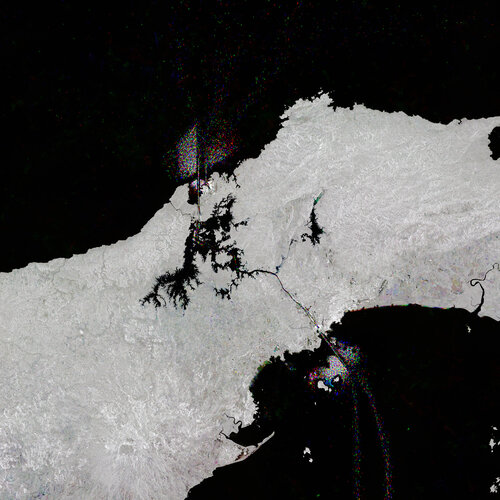 Image:
Like shining jewels in the water, ships passing through the Panama Canal, which cuts across Central America, have been captured in this Copernicus Sentinel-1 image.
Image:
Like shining jewels in the water, ships passing through the Panama Canal, which cuts across Central America, have been captured in this Copernicus Sentinel-1 image.
ředitel/ka odboru – rada /odborný rada – ředitel/ka Katastrálního pracoviště Písek (ID SM 30000218/3
19.10.2023 16:26 ČÚZK - předpisy a opatření Katastrální úřad pro Jihočeský kraj Katastrální pracoviště Písekvypisuje výběrové řízení na místo
ředitel/ka odboru – rada /odborný rada – ředitel/ka Katastrálního pracoviště Písek (ID SM 30000218/30003842)
ředitel/ka odboru – rada /odborný rada – ředitel/ka Katastrálního pracoviště Písek (ID SM 30000218/3
19.10.2023 16:26 ČÚZK - volná místa Katastrální úřad pro Jihočeský kraj Katastrální pracoviště Písek vypisuje výběrové řízení na místo ředitel/ka odboru – rada /odborný rada – ředitel/ka Katastrálního pracoviště Písek (ID SM 30000218/3ředitel/ka odboru – rada /odborný rada – ředitel/ka Katastrálního pracoviště Písek (ID SM 30000218/3
19.10.2023 16:26 ČÚZK /Urady/Katastralni-urady/Katastralni-urady/Katastralni-urad-pro-Jihocesky-kraj/Uredni-deska/Oznameni-a-jina-uredni-sdeleni/Volna-mista/DMS/reditel-ka-odboru-–-rada-odborny-rada-–-reditel-kaZníženie vplyvu ionosféry na GNSS meranie
19.10.2023 15:44 Geotronics.sk Slnečný cyklsu 25 Ako môžu ionosférické poruchy ovplyvniť určovanie polohy založené na GNSS meraní Slnečné erupcie a poruchy sú na vzostupe a očakáva sa, že vyvrcholia v roku 2025 ako súčasť slnečného cyklu 25. Tieto erupcie a rušivé vplyvy môžu mať vplyv na satelity krúžiace okolo Zeme. Preto [...]Zníženie vplyvu ionosféry na GNSS meranie
19.10.2023 15:44 Geotronics.sk Slnečný cyklsu 25 Ako môžu ionosférické poruchy ovplyvniť určovanie polohy založené na GNSS Slnečné erupcie a poruchy sú na vzostupe a očakáva sa, že vyvrcholia v roku 2025 ako súčasť slnečného cyklu 25. Tieto erupcie a rušivé vplyvy môžu mať vplyv na satelity krúžiace okolo Zeme. Preto môžete [...]RTX korekcie na rok zadarmo!
19.10.2023 15:44 Geotronics.sk Prijímače Trimble RTX + Trimble GNSSRTX korekcie zadarmoOd 1. apríla 2024 budú novo zakúpené GNSS prijímače Trimble R12i, R780, R580 a R750 obsahovať aktivované predplatné Trimble RTX pripravené na použitie počas prvých 12 mesiacov. K dispozícii sú možnosti ročného obnovenia pre pokračujúci prístup.Merajte kdekoľvek.Neobmedzujte sa internetovým pokrytím. [...]Zníženie vplyvu ionosféry na GNSS meranie
19.10.2023 15:44 Geotronics.sk Slnečný cyklus 25 Ako môžu ionosférické poruchy ovplyvniť určovanie polohy založené na GNSS meraní Slnečné erupcie a poruchy sú na vzostupe a očakáva sa, že vyvrcholia v roku 2025 ako súčasť slnečného cyklu 25. Tieto erupcie a rušivé vplyvy môžu mať vplyv na satelity krúžiace okolo Zeme. Preto [...]RTX korekcie na rok zadarmo!
19.10.2023 15:44 Geotronics.sk Prijímače Trimble RTX + Trimble GNSS RTX korekcie zadarmo Od 1. apríla 2024 budú novo zakúpené GNSS prijímače Trimble R12i, R780, R580 a R750 obsahovať aktivované predplatné Trimble RTX pripravené na použitie počas prvých 12 mesiacov. K dispozícii sú možnosti ročného obnovenia pre pokračujúci prístup. Merajte kdekoľvek. Neobmedzujte sa internetovým pokrytím. [...]RTX korekcie na rok zadarmo!
19.10.2023 15:44 Geotronics.sk Prijímače Trimble RTX + Trimble GNSSRTX korekcie zadarmoOd 1. apríla 2024 budú novo zakúpené GNSS prijímače Trimble R12i, R780, R580 a R750 obsahovať aktivované predplatné Trimble RTX pripravené na použitie počas prvých 12 mesiacov. K dispozícii sú možnosti ročného obnovenia pre pokračujúci prístup.Merajte kdekoľvek.Neobmedzujte sa internetovým pokrytím. Využite [...]Copernicus operations resilience: Inuvik wildfires
19.10.2023 15:00 ESA Observing the Earth
Copernicus operations resilience: Inuvik wildfires
10 ways EU Space helps fight global hunger
19.10.2023 14:50 European GNSS Agency
The world’s population is growing, meaning there’s more mouths to feed. With climate change wreaking havoc on global food supply chains, doing so in a sustainable manner becomes increasingly difficult. That’s why initiatives like the World Food Day are so critical.
Celebrated every 16 October, World Food Day puts the spotlight on the importance of sustainable food systems and combating global hunger. It highlights actions happening across the world where the EU is taking steps to strengthen global food systems through humanitarian and international assistance and cooperation.
Supporting these steps is the EU Space Programme.
Here are 10 concrete ways EU Space helps address the global food security challenge:
1. Earth Observation data is regularly used to monitor crop seasons. For example, when satellite imagery coverage is integrated with field surveys, one can quantify the areas to be planted and, later to be harvested.
2. The use of GNSS together with Earth observation for planting crops can determine where to apply fertilisers and pesticides, thereby reducing their use. In fact, it is estimated that using Earth Observation and GNSS together can help increase yields by more than 10% while reducing the use of fuel, fertiliser and pesticides by up to 20%.
Read More: Can we halve the use of pesticides in the EU by 2030?
3. Galileo and Copernicus data are also behind operational solutions as farm machinery guidance, precision irrigation and variable rate application. These tools increase the productivity of agricultural cultivation by supporting informed management processes and optimising the use of land, seeds, plant protection agents and water.
4. Earth Observation is the most accessible and effective way of acquiring information on site-specific crop properties over broad areas – information that can help increase the efficiency of farming operations. Specifically, the Copernicus Land Monitoring Service (CLMS) provides data on vegetation, water cycle, crop yield forecasting and soil condition monitoring.
5. As a key enabler of precision farming, Galileo and EGNOS allow farmers to optimise the space between planted seeds, which further boosts productivity and yields and reduce energy use.
6. Earth Observation images that are complemented by GNSS (including Galileo and EGNOS) can be used to evaluate and provide early warnings about drought and crop yields, giving governments a powerful tool to tackle famine in a timely fashion.
7. The use of Galileo and Copernicus is proving useful in livestock management. For example, Galileo-enabled collars – used to monitor livestock – support the activities of the breeders while Copernicus data helps them identify the most suitable grazing area.
8. Within fisheries, Copernicus is used to help assess fish stocks and to optimise fishing efforts. Together with GNSS, it can also help prevent illegal, unreported and unregulated (IUU) fishing.
Read More: Partnering to promote sustainable fisheries and aquafarms
9. In the aquaculture sector, both Earth Observation and GNSS applications contribute to the optimisation and planning of aquaculture operations by providing a host of information to aquafarmers. This information is used to select the best site for their fish farms and determine water quality in lakes and reservoirs or along coastal areas.
10. EGNSS constitutes a vital link within the food supply chain, providing the precise positioning needed to, for example, track food products being transported by air, land and sea.
Clearly, sustainable food systems start with EU Space. “Leveraging the power of EU Space puts us in a better position to answer the food security challenge and paves the way to being able to sustainably feed the world’s growing population,” concludes da Costa.
Want to learn more about how the EU Space Programme benefits agriculture and food supply chains? Then be sure to download our EU Space for Agriculture brochure and read our joint report with the United Nations Office for Outer Space Affairs (UNOOSA) entitled EU Space Supporting a World of 8 Billion People.
Media note: This feature can be republished without charge provided the European Union Agency for the Space Programme (EUSPA) is acknowledged as the source at the top or the bottom of the story. You must request permission before you use any of the photographs on the site. If you republish, we would be grateful if you could link back to the EUSPA website (http://www.euspa.europa.eu).
ředitel/ka sekce – rada /odborný rada – ředitel/ka Katastrálního pracoviště České Budějovice (ID SM
19.10.2023 13:54 ČÚZK - volná místa Katastrální úřad pro Jihočeský kraj Katastrální pracoviště České Budějovice vypisuje výběrové řízení na místo ředitel/ka sekce – rada /odborný rada – ředitel/ka Katastrálního pracoviště České Budějovice (ID SMředitel/ka sekce – rada /odborný rada – ředitel/ka Katastrálního pracoviště České Budějovice (ID SM
19.10.2023 13:54 ČÚZK /Urady/Katastralni-urady/Katastralni-urady/Katastralni-urad-pro-Jihocesky-kraj/Uredni-deska/Oznameni-a-jina-uredni-sdeleni/Volna-mista/DMS/reditel-ka-sekce-–-rada-odborny-rada-–-reditel-ka-ředitel/ka sekce – rada /odborný rada – ředitel/ka Katastrálního pracoviště České Budějovice (ID SM
19.10.2023 13:54 ČÚZK - předpisy a opatření Katastrální úřad pro Jihočeský kraj Katastrální pracoviště České Budějovicevypisuje výběrové řízení na místo
ředitel/ka sekce – rada /odborný rada – ředitel/ka Katastrálního pracoviště České Budějovice (ID SM 30000082/30003706)
Atlas veřejné správy (TZ)
19.10.2023 8:15 GISportal.cz
Atlas veřejné správy je novým projektem Ministerstva vnitra ČR. Cílem webového portálu je zpřístupnění dat o veřejné správě pomocí map široké skupině uživatelů. Veřejná správa každý rok zveřejňuje velké množství zajímavých dat o české veřejné správě. Ta jsou však často publikována na různých místech, v různých formátech a v různých obdobích roku. Mapový portál některá tato […]
The post Atlas veřejné správy (TZ) appeared first on GISportal.cz.
odborný rada - vedoucí oddělení právních vztahů k nemovitostem Katastrálního pracoviště Jičín
19.10.2023 7:47 ČÚZK - předpisy a opatření Katastrální úřad pro Královéhradecký krajvypisuje výběrové řízení na místo
odborný rada - vedoucí oddělení právních vztahů k nemovitostem Katastrálního pracoviště Jičín
odborný rada - vedoucí oddělení právních vztahů k nemovitostem Katastrálního pracoviště Jičín
19.10.2023 7:47 ČÚZK - volná místa Katastrální úřad pro Královéhradecký kraj vypisuje výběrové řízení na místo odborný rada - vedoucí oddělení právních vztahů k nemovitostem Katastrálního pracoviště JičínRada/odborný rada - inspektor ZKI v Liberci
18.10.2023 16:44 ČÚZK - předpisy a opatření Zeměměřický a katastrální inspektorát v Libercivypisuje výběrové řízení na místo
Rada/odborný rada - inspektor ZKI v Liberci
Rada/odborný rada - inspektor ZKI v Liberci
18.10.2023 16:44 ČÚZK /Urady/Zememericke-a-katastralni-inspektoraty/Zememericke-a-katastralni-inspektoraty/Zememericky-a-katastralni-inspektorat-v-Liberci/Uredni-deska/Oznameni-a-jina-uredni-sdeleni/Volna-mista/DMS/Oznameni-o-vyhlaseni-vyberoveho-rizeni-inspektor-ZOznámení o vyhlášení výběrového řízení - inspektor ZKI v Liberci
18.10.2023 16:44 ČÚZK - předpisy a opatření Zeměměřický a katastrální inspektorát v Libercivypisuje výběrové řízení na místo
Oznámení o vyhlášení výběrového řízení - inspektor ZKI v Liberci
Rada/odborný rada - inspektor ZKI v Liberci
18.10.2023 16:44 ČÚZK - volná místa Zeměměřický a katastrální inspektorát v Liberci vypisuje výběrové řízení na místo Rada/odborný rada - inspektor ZKI v LiberciOznámení o vyhlášení výběrového řízení - inspektor ZKI v Liberci
18.10.2023 16:44 ČÚZK - volná místa Zeměměřický a katastrální inspektorát v Liberci vypisuje výběrové řízení na místo Oznámení o vyhlášení výběrového řízení - inspektor ZKI v LiberciOznámení o vyhlášení výběrového řízení - inspektor ZKI v Liberci
18.10.2023 16:44 ČÚZK /Urady/Zememericke-a-katastralni-inspektoraty/Zememericke-a-katastralni-inspektoraty/Zememericky-a-katastralni-inspektorat-v-Liberci/Uredni-deska/Oznameni-a-jina-uredni-sdeleni/Volna-mista/DMS/Oznameni-o-vyhlaseni-vyberoveho-rizeni-inspektor-ZSetkání manažerů s Jackem Dangermondem (report)
18.10.2023 11:07 GISportal.cz
Minulý týden ve čtvrtek 12. října proběhlo v Praze setkání manažerů v Jackem Dangermondem, kterého se zúčastnilo okolo 60 zástupců firem, státní správy a pár zástupců univerzit. Jack Dangermond založil společnost Esri v roce 1969 se svoji ženou Laurou a do dnešního dne je stále jejím majitelem. Na myšlenku založit Esri přišli jako studenti na […]
The post Setkání manažerů s Jackem Dangermondem (report) appeared first on GISportal.cz.
20231017 - VŘ ředitel/ka KÚ pro Karlovarský kraj
17.10.2023 17:06 ČÚZK - aktuality v resortu Oznámení o vyhlášení výběrového řízení na služební místo vedoucí služebního úřadu - ředitel/ka Katastrálního úřadu pro Karlovarský kraj.20231017 - VŘ ředitel/ka KÚ pro Karlovarský kraj
17.10.2023 17:06 ČÚZK /Aktuality-resort/2023/20231017-VR-reditel-ka-KU-pro-Karlovarsky-kraj20231017 - VŘ ředitel/ka KÚ pro Karlovarský kraj
17.10.2023 17:06 ČÚZK - předpisy a opatření Český úřad zeměměřický a katastrální zveřejnil novou aktualitu: Oznámení o vyhlášení výběrového řízení na služební místo vedoucí služebního úřadu - ředitel/ka Katastrálního úřadu pro Karlovarský kraj.Vedoucí služebního úřadu - ředitel/ředitelka Katastrálního úřadu pro Karlovarský kraj
17.10.2023 16:55 ČÚZK - předpisy a opatření Český úřad zeměměřický a katastrálnívypisuje výběrové řízení na místo
Vedoucí služebního úřadu - ředitel/ředitelka Katastrálního úřadu pro Karlovarský kraj
Vedoucí služebního úřadu - ředitel/ředitelka Katastrálního úřadu pro Karlovarský kraj
17.10.2023 16:55 ČÚZK - volná místa Český úřad zeměměřický a katastrální vypisuje výběrové řízení na místo Vedoucí služebního úřadu - ředitel/ředitelka Katastrálního úřadu pro Karlovarský krajVedoucí služebního úřadu - ředitel/ředitelka Katastrálního úřadu pro Karlovarský kraj
17.10.2023 16:55 ČÚZK /Urady/Cesky-urad-zememericky-a-katastralni/Uredni-deska/Oznameni-a-jina-uredni-sdeleni/Volna-mista/DMS/Vedouci-sluzebniho-uradu-reditel-reditelka-Katastr20231017 - VŘ ředitel/ka ZKI v Pardubicích
17.10.2023 16:39 ČÚZK - aktuality v resortu Oznámení o vyhlášení výběrového řízení na služební místo vedoucí služebního úřadu - ředitel/ka Zeměměřického a katastrálního inspektorátu v Pardubicích.20231017 - VŘ ředitel/ka ZKI v Pardubicích
17.10.2023 16:39 ČÚZK - předpisy a opatření Český úřad zeměměřický a katastrální zveřejnil novou aktualitu: Oznámení o vyhlášení výběrového řízení na služební místo vedoucí služebního úřadu - ředitel/ka Zeměměřického a katastrálního inspektorátu v Pardubicích.20231017 - VŘ ředitel/ka ZKI v Pardubicích
17.10.2023 16:39 ČÚZK /Aktuality-resort/2023/20231017-VR-reditel-ka-ZKI-v-PardubicichVedoucí služebního úřadu - ředitel/ka Zeměměřického a katastrálního úřadu v Pardubicích
17.10.2023 16:29 ČÚZK - předpisy a opatření Český úřad zeměměřický a katastrálnívypisuje výběrové řízení na místo
Vedoucí služebního úřadu - ředitel/ka Zeměměřického a katastrálního úřadu v Pardubicích
Vedoucí služebního úřadu - ředitel/ka Zeměměřického a katastrálního inspektorátu v Pardubicích
17.10.2023 16:29 ČÚZK - volná místa Český úřad zeměměřický a katastrální vypisuje výběrové řízení na místo Vedoucí služebního úřadu - ředitel/ka Zeměměřického a katastrálního inspektorátu v PardubicíchVedoucí služebního úřadu - ředitel/ka Zeměměřického a katastrálního inspektorátu v Pardubicích
17.10.2023 16:29 ČÚZK - předpisy a opatření Český úřad zeměměřický a katastrálnívypisuje výběrové řízení na místo
Vedoucí služebního úřadu - ředitel/ka Zeměměřického a katastrálního inspektorátu v Pardubicích
Vedoucí služebního úřadu - ředitel/ka Zeměměřického a katastrálního inspektorátu v Pardubicích
17.10.2023 16:29 ČÚZK /Urady/Cesky-urad-zememericky-a-katastralni/Uredni-deska/Oznameni-a-jina-uredni-sdeleni/Volna-mista/DMS/Vedouci-sluzebniho-uradu-reditel-ka-Zememerick-(2)Vedoucí služebního úřadu - ředitel/ka Zeměměřického a katastrálního úřadu v Pardubicích
17.10.2023 16:29 ČÚZK - volná místa Český úřad zeměměřický a katastrální vypisuje výběrové řízení na místo Vedoucí služebního úřadu - ředitel/ka Zeměměřického a katastrálního úřadu v PardubicíchVedoucí služebního úřadu - ředitel/ka Zeměměřického a katastrálního úřadu v Pardubicích
17.10.2023 16:29 ČÚZK /Urady/Cesky-urad-zememericky-a-katastralni/Uredni-deska/Oznameni-a-jina-uredni-sdeleni/Volna-mista/DMS/Vedouci-sluzebniho-uradu-reditel-ka-Zememerick-(2)20231017 - VŘ ředitel/ka ZKI v ČB
17.10.2023 16:22 ČÚZK - předpisy a opatření Český úřad zeměměřický a katastrální zveřejnil novou aktualitu: Oznámení o vyhlášení výběrového řízení na služební místo vedoucí služebního úřadu - ředitel/ka Zeměměřického a katastrálního inspektorátu v Českých Budějovicích.20231017 - VŘ ředitel/ka ZKI v ČB
17.10.2023 16:22 ČÚZK - aktuality v resortu Oznámení o vyhlášení výběrového řízení na služební místo vedoucí služebního úřadu - ředitel/ka Zeměměřického a katastrálního inspektorátu v Českých Budějovicích.20231017 - VŘ ředitel/ka ZKI v ČB
17.10.2023 16:22 ČÚZK /Aktuality-resort/2023/20231017-VR-reditel-ka-ZKI-v-CB20231017 - VŘ ředitel/ka ZKI v ČB
17.10.2023 16:22 ČÚZK - aktuality v resortu Oznámení o vyhlášení výběrového řízení na služební místo vedoucí služebního úřadu - ředitel/ka Zeměměřického a katastrálního inspektorátu v Českých Budějovicích.20231017 - VŘ ředitel/ka ZKI v ČB
17.10.2023 16:22 ČÚZK - předpisy a opatření Český úřad zeměměřický a katastrální zveřejnil novou aktualitu: Oznámení o vyhlášení výběrového řízení na služební místo vedoucí služebního úřadu - ředitel/ka Zeměměřického a katastrálního inspektorátu v Českých Budějovicích.Vedoucí služebního úřadu - ředitel/ka Zeměměřického a katastrálního inspektorátu v Českých Budějovic
17.10.2023 16:15 ČÚZK - volná místa Český úřad zeměměřický a katastrální vypisuje výběrové řízení na místo Vedoucí služebního úřadu - ředitel/ka Zeměměřického a katastrálního inspektorátu v Českých BudějovicVedoucí služebního úřadu - ředitel/ka Zeměměřického a katastrálního inspektorátu v Českých Budějovic
17.10.2023 16:15 ČÚZK /Urady/Cesky-urad-zememericky-a-katastralni/Uredni-deska/Oznameni-a-jina-uredni-sdeleni/Volna-mista/DMS/Vedouci-sluzebniho-uradu-reditel-ka-Zememerick-(1)Vedoucí služebního úřadu - ředitel/ka Zeměměřického a katastrálního inspektorátu v Českých Budějovic
17.10.2023 16:15 ČÚZK - předpisy a opatření Český úřad zeměměřický a katastrálnívypisuje výběrové řízení na místo
Vedoucí služebního úřadu - ředitel/ka Zeměměřického a katastrálního inspektorátu v Českých Budějovicích
20231017 - VŘ ředitel/ka ZKI v Brně
17.10.2023 16:07 ČÚZK - předpisy a opatření Český úřad zeměměřický a katastrální zveřejnil novou aktualitu: Oznámení o vyhlášení výběrového řízení na služební místo vedoucí služebního úřadu - ředitel/ka Zeměměřického a katastrálního inspektorátu v Brně.20231017 - VŘ ředitel/ka ZKI v Brně
17.10.2023 16:07 ČÚZK /Aktuality-resort/2023/20231017-VR-reditel-ka-ZKI-v-Brne20231017 - VŘ ředitel/ka ZKI v Brně
17.10.2023 16:07 ČÚZK - předpisy a opatření Český úřad zeměměřický a katastrální zveřejnil novou aktualitu: Oznámení o vyhlášení výběrového řízení na služební místo vedoucí služebního úřadu - ředitel/ka Zeměměřického a katastrálního inspektorátu v Brně (17.10.2023 - 13.11.2023).20231017 - VŘ ředitel/ka ZKI v Brně
17.10.2023 16:07 ČÚZK - aktuality v resortu Oznámení o vyhlášení výběrového řízení na služební místo vedoucí služebního úřadu - ředitel/ka Zeměměřického a katastrálního inspektorátu v Brně.20231017 - VŘ ředitel/ka ZKI v Brně
17.10.2023 16:07 ČÚZK - aktuality v resortu Oznámení o vyhlášení výběrového řízení na služební místo vedoucí služebního úřadu - ředitel/ka Zeměměřického a katastrálního inspektorátu v Brně (17.10.2023 - 13.11.2023).Vedoucí služebního úřadu - ředitel/ka Zeměměřického a katastrálního inspektorátu v Brně
17.10.2023 15:58 ČÚZK /Urady/Cesky-urad-zememericky-a-katastralni/Uredni-deska/Oznameni-a-jina-uredni-sdeleni/Volna-mista/DMS/Vedouci-sluzebniho-uradu-reditel-ka-Zememerickeho-Vedoucí služebního úřadu - ředitel/ka Zeměměřického a katastrálního inspektorátu v Brně
17.10.2023 15:58 ČÚZK - volná místa Český úřad zeměměřický a katastrální vypisuje výběrové řízení na místo Vedoucí služebního úřadu - ředitel/ka Zeměměřického a katastrálního inspektorátu v BrněVedoucí služebního úřadu - ředitel/ka Zeměměřického a katastrálního inspektorátu v Brně
17.10.2023 15:58 ČÚZK - předpisy a opatření Český úřad zeměměřický a katastrálnívypisuje výběrové řízení na místo
Vedoucí služebního úřadu - ředitel/ka Zeměměřického a katastrálního inspektorátu v Brně
Satnav test on remote island lab
17.10.2023 14:45 ESA Navigation
ESA’s navigation testbed vehicle participated in a campaign organised by Norwegian governmental authorities to assess the impact of jamming and spoofing on satnav systems and test innovative technologies for detection and mitigation.
Odborný referent/vrchní referent – poskytování informací a nahlížení do KN
17.10.2023 11:16 ČÚZK /Urady/Katastralni-urady/Katastralni-urady/Katastralni-urad-pro-hlavni-mesto-Prahu/O-uradu/Aktuality/Odborny-referent-vrchni-referent-–-poskytovani-infOdborný referent/vrchní referent – poskytování informací a nahlížení do KN
17.10.2023 11:16 ČÚZK - předpisy a opatření Katastrální úřad pro hlavní město Prahu zveřejnil novou aktualitu: Ředitelka úřadu vyhlašuje výběrové řízení na služební místo:Odborný referent/vrchní referent – poskytování informací a nahlížení do KN
Odborný referent/vrchní referent – poskytování informací a nahlížení do KN
17.10.2023 11:14 ČÚZK - volná místa Katastrální úřad pro hlavní město Prahu vypisuje výběrové řízení na místo Odborný referent/vrchní referent – poskytování informací a nahlížení do KNOdborný referent/vrchní referent – poskytování informací a nahlížení do KN
17.10.2023 11:14 ČÚZK - předpisy a opatření Katastrální úřad pro hlavní město Prahuvypisuje výběrové řízení na místo
Odborný referent/vrchní referent – poskytování informací a nahlížení do KN
Odborný referent/vrchní referent – poskytování informací a nahlížení do KN
17.10.2023 11:14 ČÚZK /Urady/Katastralni-urady/Katastralni-urady/Katastralni-urad-pro-hlavni-mesto-Prahu/Uredni-deska/Oznameni-a-jina-uredni-sdeleni/Volna-mista/Odborny-referent-vrchni-referent-–-poskytovani-infAfter upgrading the constellation, EUSPA re-opens the call for INAV improvements testing
17.10.2023 11:11 European GNSS Agency Open Service Signal-In-Space Interface Control Document (OS SIS ICD) Issue 2.0 contains publicly available information on the Galileo Signal-In-Space.")
The Galileo Open Service (OS) has been upgraded with three new features added to its I/NAV message, one of the four message types broadcast by Galileo satellites. Collectively referred to simply as “I/NAV improvements”, these features are now available to all Open Service users. On 12 August 2023, the gradual process of upgrading the operational Galileo FOC constellation satellites was finalized. The I/NAV improvements are openly accessible through the I/NAV message carried by the E1-B signal.
The testing will cover any of the three I/NAV improvements (SSP, FEC-2, RedCED), that will be tested in laboratories using simulated realistic scenarios, including open sky as well as impaired environments, but also using Signal-in-Space. The tests will allow the participants to have confirmation of the correct implementation of the OSSISICD 2.0.
The characteristics of the testing campaign are described here.
The interested participants may be invited to provide their product(s) before 15 November 2023, 15 March 2024 or 15 June 2024 to the premises indicated below according to the terms and conditions that will be communicated by the agency and be ready to provide any remote technical assistance needed during the testing as well as all the necessary interface documentation required for the testing.
The tests will be executed at the laboratories of the European Commission’s Joint Research Centre in Ispra, Italy, and of the European Space Agency ESA/ESTEC in Noordwijk, The Netherlands. Each applicant will be assigned by EUSPA to any of the two laboratories depending on the specific conditions and availability.
Express your interest
If you are interested in participating in the testing campaign above, please express your interest by sending an email at least 15 days before any of the testing windows indicated above (i.e. 30/10/2023, 29/02/2024 and 31/05/2024, 17:00 (Prague local time) respectively) to the following email address: market@euspa.europa.eu. The subject of the email shall be “INAV improvements implementation testing campaign: 3rd call”.
Media note: This feature can be republished without charge provided the European Union Agency for the Space Programme (EUSPA) is acknowledged as the source at the top or the bottom of the story. You must request permission before you use any of the photographs on the site. If you republish, we would be grateful if you could link back to the EUSPA website (http://www.euspa.europa.eu).
20231017 - volné místo - Odborný/vrchní referent v PO kanceláře ředitele KÚ pro ÚK
17.10.2023 10:32 ČÚZK /Urady/Katastralni-urady/Katastralni-urady/Katastralni-urad-pro-Ustecky-kraj/O-uradu/Aktuality/20231017-volne-misto-Odborny-vrchni-referent-v-PO20231017 - volné místo - Odborný/vrchní referent v PO kanceláře ředitele KÚ pro ÚK
17.10.2023 10:32 ČÚZK - předpisy a opatření Katastrální úřad pro Ústecký kraj zveřejnil novou aktualitu: Nabídka volného místa - Odborný / vrchní referent v personálním oddělení kanceláře ředitele katastrálního úřadu na Katastrálním úřadu pro Ústecký kraj
Nové číslo GaKO
17.10.2023 8:20
ÚGKK SR
Nové číslo časopisu Geodetického a Kartografického Obzoru 10/2023
Nová sestavení programu GEUS 28.0.3.396, resp. GEUS 27.0.5.377
16.10.2023 16:13 GEUSwareByla uvolněna nová sestavení programu GEUS 28.0.3.396 (resp. i GEUS 27.0.5.377). Tato sestavení mimo jiné reagují na nové možnosti služeb WSGP od 8.9.2023, do GEUSu byly přidány funkce umožňujících generovat LV a stahovat ZPMZ pomocí služby WSGP. Pro snažší orientaci v nových funkcích jsme pro naše uživatele připravili krátká videa - viz článek.
Vzorové dokumenty pro smluvní dokumentaci s využitím BIM
16.10.2023 15:28 czBIMVzniknou vzorové dokumenty pro smluvní dokumentaci s využitím BIM. Česká agentura pro standardizaci na nich spolupracuje s Havel & Partners a czBIM Praha 12. října...
Článek Vzorové dokumenty pro smluvní dokumentaci s využitím BIM se nejdříve objevil na czBIM.
Videa k novým funkcím generování LV a stahování ZPMZ pomocí WSGP
16.10.2023 15:03 GEUSwarePro naše uživatele jsme připravili videa s předvedením nových funkcí umožňujících generovat LV a stahovat ZPMZ pomocí služby WSGP (jedná se o nové funkce webové služby od 8.9.2023). Funkce jsou dostupné v GEUS 28.0.3.396 (resp. i GEUS 27.0.5.377).
Generace LV pomocí služby WSGP - pokud Vám video nejde spustit z našich stránek, vyzkoušejte odkaz na YouTube.
Stažení ZPMZ pomocí služby WSGP - pokud Vám video nejde spustit z našich stránek, vyzkoušejte odkaz na YouTube.
RoadShow 2023 – shrnutí
16.10.2023 12:01 3gon RoadShow 2023 je úspěšně za námi! 💪 Děkujeme všem z Prahy, Českých Budějovic, Brna, Ostravy i z Hradce Králové oRoadShow 2023 – shrnutí
16.10.2023 12:01 3gon RoadShow 2023 je úspěšně za námi! 💪Děkujeme všem z Prahy, Českých Budějovic, Brna, Ostravy i z Hradce Králové o zájemDid You Miss INTERGEO? Watch the Replay of SatLab
16.10.2023 10:06 Satlab GeosolutionsThe world of geospatial technology witnessed a groundbreaking event as SatLab, a leading player in […]
The post Did You Miss INTERGEO? Watch the Replay of SatLab appeared first on Global Satellite Positioning Solutions | SatLab Geosolutions AB.
Seminář 8. 11. 2023
16.10.2023 10:05 ČÚZK - předpisy a opatření Český úřad zeměměřický a katastrální oznamuje, že dne 8. listopadu 2023 uspořádá další odborný seminář pro zástupce vlastníků, správců a provozovatelů dopravní a technické infrastruktury (DTI), který bude tentokrát zaměřen na problematiku zakládání, správy a aktualizace částí a rozsahů editace DTI v Informačním systému digitální mapy veřejné správy. Veškeré podrobnosti (včetně nutné registrace) naleznete v pozvánceAktualizace prohlížecí služby RÚIAN
16.10.2023 10:00 ČÚZK - Geoportál Aktualizace prohlížecí služby RÚIANDo prohlížecí služby nad daty Registru územní identifikace adres a nemovitostí (RÚIAN) byly doplněny vrstvy Účelových územních prvků (ÚÚP) a volebních okrsků (Layers ID 20 až 25).
Zobrazování vrstev je ve výchozím stavu vypnuté. Vrstvy mají pro zobrazování měřítková omezení.
Aktualizace prohlížecí služby RÚIAN
16.10.2023 10:00 ČÚZK - Geoportál Aktualizace prohlížecí služby RÚIANDo prohlížecí služby nad daty Registru územní identifikace adres a nemovitostí (RÚIAN) byly doplněny vrstvy Účelových územních prvků (ÚÚP) a volebních okrsků (Layers ID 20 až 25).
Zobrazování vrstev je ve výchozím stavu vypnuté. Vrstvy mají pro zobrazování měřítková omezení.
20231114-Gako 11/2023
16.10.2023 9:06 ČÚZK - předpisy a opatření Český úřad zeměměřický a katastrální zveřejnil novou aktualitu: Aktuální číslo Geodetického a kartografického obzoru (11/2023) je k dispozici ke stažení.20231114-Gako 12/2023
16.10.2023 9:06 ČÚZK - předpisy a opatření Český úřad zeměměřický a katastrální zveřejnil novou aktualitu: Aktuální číslo Geodetického a kartografického obzoru (12/2023) je k dispozici ke stažení.20231114-Gako 12/2023
16.10.2023 9:06 ČÚZK - aktuality v resortu Aktuální číslo Geodetického a kartografického obzoru (12/2023) je k dispozici ke stažení.20231016-Gako 10/2023
16.10.2023 9:06 ČÚZK - předpisy a opatření Český úřad zeměměřický a katastrální zveřejnil novou aktualitu: Aktuální číslo Geodetického a kartografického obzoru (10/2023) je k dispozici ke stažení.20231016-Gako 10/2023
16.10.2023 9:06 ČÚZK - předpisy a opatření Český úřad zeměměřický a katastrální zveřejnil novou aktualitu: Aktuální číslo Geodetického a kartografického obzoru (10/2023) je k dispozici ke stažení.20231114-Gako 11/2023
16.10.2023 9:06 ČÚZK - aktuality v resortu Aktuální číslo Geodetického a kartografického obzoru (11/2023) je k dispozici ke stažení.20231016-Gako 10/2023
16.10.2023 9:06 ČÚZK - aktuality v resortu Aktuální číslo Geodetického a kartografického obzoru (10/2023) je k dispozici ke stažení.20231016-Gako 10/2023
16.10.2023 9:06 ČÚZK - aktuality v resortu Aktuální číslo Geodetického a kartografického obzoru (10/2023) je k dispozici ke stažení.Aktualizace prohlížecí služby RÚIAN
16.10.2023 9:00 ČÚZK - Geoportál Aktualizace prohlížecí služby RÚIANDo prohlížecí služby nad daty Registru územní identifikace adres a nemovitostí (RÚIAN) byly doplněny vrstvy Účelových územních prvků (ÚÚP) a volebních okrsků (Layers ID 20 až 25).
Zobrazování vrstev je ve výchozím stavu vypnuté. Vrstvy mají pro zobrazování měřítková omezení.
Aktualizace prohlížecí služby RÚIAN
16.10.2023 9:00 ČÚZK - Geoportál Aktualizace prohlížecí služby RÚIANDo prohlížecí služby nad daty Registru územní identifikace adres a nemovitostí (RÚIAN) byly doplněny vrstvy Účelových územních prvků (ÚÚP) a volebních okrsků (Layers ID 20 až 25).
Zobrazování vrstev je ve výchozím stavu vypnuté. Vrstvy mají pro zobrazování měřítková omezení.