


![]()

zprávy
zdroje zpráv:Rhodes wildfire forces thousands to flee
24.7.2023 14:58 ESA Observing the Earth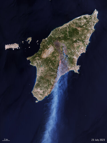 Image:
Rhodes wildfire forces thousands to flee
Image:
Rhodes wildfire forces thousands to flee
Odborný referent v oddělení dokumentace KN na Katastrálním pracovišti Hodonín
24.7.2023 12:54 ČÚZK - předpisy a opatření Katastrální úřad pro Jihomoravský kraj Katastrální pracoviště Hodonínvypisuje výběrové řízení na místo
Odborný referent v oddělení dokumentace KN na Katastrálním pracovišti Hodonín
Odborný referent v oddělení dokumentace KN na Katastrálním pracovišti Hodonín
24.7.2023 12:54 ČÚZK /Urady/Katastralni-urady/Katastralni-urady/Katastralni-urad-pro-Jihomoravsky-kraj/Volna-mista/DMS/Odborny-referent-v-oddeleni-dokumentace-KN-na-KataOdborný referent v oddělení dokumentace KN na Katastrálním pracovišti Hodonín
24.7.2023 12:54 ČÚZK - volná místa Katastrální úřad pro Jihomoravský kraj Katastrální pracoviště Hodonín vypisuje výběrové řízení na místo Odborný referent v oddělení dokumentace KN na Katastrálním pracovišti Hodonín20230724_odborný referent v oddělení obnovy a revize odboru geodetických informací
24.7.2023 12:48 ČÚZK - předpisy a opatření Katastrální úřad pro Středočeský kraj - Katastrální pracoviště Praha-východ Nabídka pracovní pozice: Odborný referent v oddělení obnovy a revize odboru geodetických informací V části "Volná místa" byla vystavena "Nabídka pracovní pozice na systemizované místoodborný referent v oddělení obnovy a revize odboru geodetických informací"
20230724_odborný referent v oddělení obnovy a revize odboru geodetických informací
24.7.2023 12:48 ČÚZK /Urady/Katastralni-urady/Katastralni-urady/Katastralni-urad-pro-Stredocesky-kraj/Katastralni-pracoviste/KP-Praha-vychod/O-uradu/Aktuality/20230724_odborny-referent-v-oddeleni-obnovy-a-reviOdborný referent v oddělení obnovy a revize odboru geodetických informací
24.7.2023 12:34 ČÚZK - předpisy a opatření Katastrální úřad pro Středočeský kraj Katastrální pracoviště Praha-východvypisuje výběrové řízení na místo
Odborný referent v oddělení obnovy a revize odboru geodetických informací
Odborný referent v oddělení obnovy a revize odboru geodetických informací
24.7.2023 12:34 ČÚZK /Urady/Katastralni-urady/Katastralni-urady/Katastralni-urad-pro-Stredocesky-kraj/Volna-mista/DMS/Odborny-referent-v-oddeleni-obnovy-a-revize-odboruOdborný referent v oddělení obnovy a revize odboru geodetických informací
24.7.2023 12:34 ČÚZK - volná místa Katastrální úřad pro Středočeský kraj Katastrální pracoviště Praha-východ vypisuje výběrové řízení na místo Odborný referent v oddělení obnovy a revize odboru geodetických informacíNew Galileo station goes on duty
24.7.2023 12:12 ESA Navigation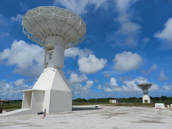 Image:
New Galileo station goes on duty
Image:
New Galileo station goes on duty
zápisy v řízení V a Z v oddělení právních vztahů k nemovitostem Katastrálního pracoviště Český Kruml
24.7.2023 10:55 ČÚZK - volná místa Katastrální úřad pro Jihočeský kraj Katastrální pracoviště Český Krumlov vypisuje výběrové řízení na místo zápisy v řízení V a Z v oddělení právních vztahů k nemovitostem Katastrálního pracoviště Český Krumlzápisy v řízení V a Z v oddělení právních vztahů k nemovitostem Katastrálního pracoviště Český Kruml
24.7.2023 10:55 ČÚZK - předpisy a opatření Katastrální úřad pro Jihočeský kraj Katastrální pracoviště Český Krumlovvypisuje výběrové řízení na místo
zápisy v řízení V a Z v oddělení právních vztahů k nemovitostem Katastrálního pracoviště Český Krumlov (ID SM 30000156/30003780)
zápisy v řízení V a Z v oddělení právních vztahů k nemovitostem Katastrálního pracoviště Český Kruml
24.7.2023 10:55 ČÚZK /Urady/Katastralni-urady/Katastralni-urady/Katastralni-urad-pro-Jihocesky-kraj/Uredni-deska/Oznameni-a-jina-uredni-sdeleni/Volna-mista/DMS/zapisy-v-rizeni-V-a-Z-v-oddeleni-pravnich-vztahu-k20230725 - volné místo - Odborný/vrchní referent v OMaK kanceláře ředitele KÚ na Katastrálním úřadu
24.7.2023 10:50 ČÚZK - předpisy a opatření Katastrální úřad pro Ústecký kraj zveřejnil novou aktualitu: Nabídka volného místa - Odborný referent / vrchní referent v oddělení metodiky a kontroly kanceláře ředitele katastrálního úřadu na Katastrálním úřadu pro Ústecký kraj20230725 - volné místo - Odborný/vrchní referent v OMaK kanceláře ředitele KÚ na Katastrálním úřadu
24.7.2023 10:50 ČÚZK /Urady/Katastralni-urady/Katastralni-urady/Katastralni-urad-pro-Ustecky-kraj/O-uradu/Aktuality/20230725-volne-misto-Odborny-vrchni-referent-v-OMaOdborný referent / vrchní referent v oddělení metodiky a kontroly kanceláře ředitele katastrálního ú
24.7.2023 10:48 ČÚZK /Urady/Katastralni-urady/Katastralni-urady/Katastralni-urad-pro-Ustecky-kraj/Uredni-deska/Oznameni-a-jina-uredni-sdeleni/Volna-mista/DMS/Odborny-referent-vrchni-referent-v-oddeleni-metodiOdborný referent / vrchní referent v oddělení metodiky a kontroly kanceláře ředitele katastrálního ú
24.7.2023 10:48 ČÚZK - předpisy a opatření Katastrální úřad pro Ústecký kraj kancelář ředitelevypisuje výběrové řízení na místo
Odborný referent / vrchní referent v oddělení metodiky a kontroly kanceláře ředitele katastrálního úřadu na Katastrálním úřadu pro Ústecký kraj
Odborný referent / vrchní referent v oddělení metodiky a kontroly kanceláře ředitele katastrálního ú
24.7.2023 10:48 ČÚZK - volná místa Katastrální úřad pro Ústecký kraj kancelář ředitele vypisuje výběrové řízení na místo Odborný referent / vrchní referent v oddělení metodiky a kontroly kanceláře ředitele katastrálního úAktualizace otevřených dat zastávek veřejné dopravy v Jihočeském kraji
24.7.2023 9:53 Jihočeský krajV sekci Doprava a silniční hospodářství byla aktualizována data zastávek veřejné dopravy v Jihočeském kraji k 30.6.2023. Data jsou k dispozici ke stažení pod licencí CC0 nebo pomocí webových služeb (WMS) či k zobrazení v mapové aplikaci.
TurboCAD MAC Deluxe CZ a ENG v akční ceně
21.7.2023 18:34 ŠPINAR - softwareVážení zákazníci, dovolujeme si Vám nabídnout program TurboCAD MAC Deluxe pro 2D a 3D kreslení v akční ceně do 2. 8.2024.
The post TurboCAD MAC Deluxe CZ a ENG v akční ceně appeared first on ŠPINAR – software.
Journey back to Earth: Aeolus' historic reentry
21.7.2023 15:00 ESA Observing the Earth Video:
00:05:00
Video:
00:05:00
ESA’s wind mission Aeolus is coming home. After five years of improving weather forecasts, the satellite will return in a first-of-its-kind assisted reentry. At ESA’s Space Operations Centre in Germany, mission control will use the satellite’s remaining fuel to steer Aeolus during its return to Earth.
Find out more about the mission, its successes and how Aeolus is paving the way for safe reentries.
Rescue drones tested within Italian volcanoes
21.7.2023 14:28 ESA Navigation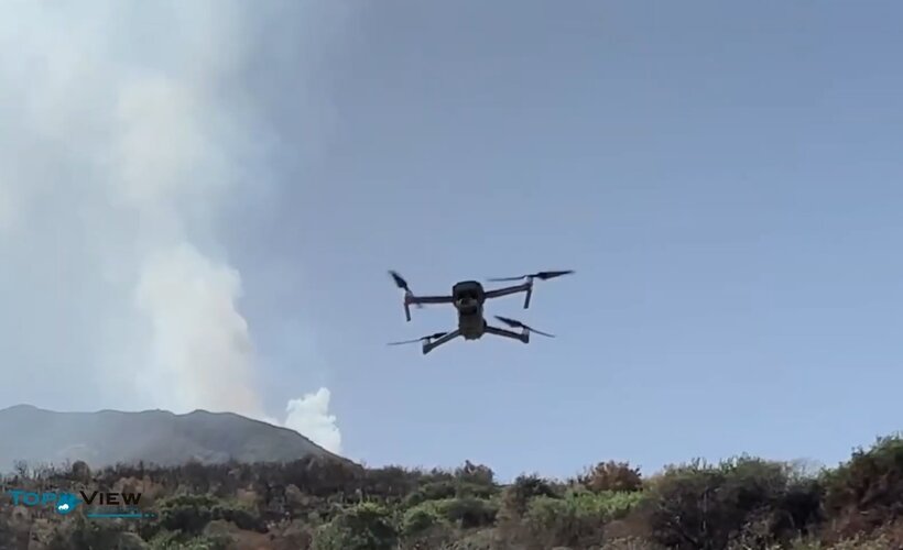
Interconnected drones have been dispatched into volcanic territory to test their use for civil protection, to help guide responses to natural disasters using novel PNT technology. The project, named Pathfinder, is supported through ESA’s Navigation Innovation and Support Programme, NAVISP. Two test campaigns have been undertaken to date, around the active Stromboli Island volcano and within the Astroni Nature Reserve, in a volcanic crater near Naples.
Setkání prezidenta Aliance s Korejským velvyslancem v ČR a prohlubování spolupráce
21.7.2023 13:24 UAVA Aliance pracuje na prohlubování potenciálu spolupráce s Jižní Korejí v oblasti dronů. Tento týden se setkal prezident Aliance s novým Korejským velvyslancem v ČR a ředitelem Korejské obchodní agentury KOTRA. Společně připravujeme na podzim tohoto roku Czechia-Korea Drone Roadshow, kdy vybraní zástupci korejského průmyslu s drony a autorit se budou společně moci setkat v Praze […]Přerušení dodávky elektřiny 10.8.2023
21.7.2023 12:29 ČÚZK /Urady/Katastralni-urady/Katastralni-urady/Katastralni-urad-pro-Moravskoslezsky-kraj/Katastralni-pracoviste/KP-Krnov/O-uradu/Aktuality/Preruseni-dodavky-elektriny-10-8-2023Přerušení dodávky elektřiny 10.8.2023
21.7.2023 12:29 ČÚZK - předpisy a opatření Katastrální úřad pro Moravskoslezský kraj - Katastrální pracoviště Krnov zveřejnil novou aktualitu: Vážení klienti,ve čtvrtek 10. 8. 2023 společnost ČEZ Distribuce, a.s. přeruší Katastrálnímu úřadu pro Moravskoslezský kraj, Katastrálnímu pracovišti Krnov dodávku elektřiny v době od 10:00 do 17:00 hod.
Služby veřejnosti zůstávají po tuto dobu (byť s omezeními vyplývajícími z uvedené skutečnosti) zachovány. Upozorňujeme, že v důsledku toho nebude možné správní poplatky hradit kartou.
Using the EU Space Programme for disaster risk management in Hungary
21.7.2023 11:10 European GNSS Agency
The recent severe droughts and extremely high temperatures in Hungary, led rivers and lakes to dry up, negatively impacting the country’s economy and ecosystem. With that in mind, EUSPA, together with the Ministry of Foreign Affairs and Trade of Hungary and Eurisy, co-organised a workshop on Satellite-based Services for Disaster Risk Management. Held in Budapest, the workshop brought together national and regional stakeholders to discuss how satellite-based services can support both disaster risk management and search and rescue operations.
Dr. Orsolya Ferencz, Ministerial Commissioner for Space Research at the Ministry of Foreign Affairs and Trade, presented an overview of Hungary's space strategy and outlined its implementation milestones. Speaking about the workshop, Dr Ferencz stated, "This gathering is important in addressing the challenges we face in emergency situations. By leveraging innovative tools and satellite technologies, we can make evidence-based decisions and better respond to disasters."
Visualising with Copernicus
Copernicus, the EU Earth Observation programme provides up to date, near real-time optical information about disasters such as wildfires and floods.
More precisely, the Copernicus Emergency Management Service (Copernicus EMS) uses data from a range of satellites and ground-based sensors to provide information about the location, extent, and behaviour of fires and floods. This information helps emergency responders make informed decisions regarding where to direct resources and in the case of fires, how to contain the blaze. The service is provided free of charge to all users.
But there’s more. Wildfires are a significant source of air pollution which poses a threat to human, animal, and plant populations.
When a disaster such as a wildfire strikes a region, it is important to have access to precise and up-to-date information for the delivery of an effective disaster management response. The Copernicus Atmosphere Monitoring Service (CAMS) can monitor emissions which can, in turn, be used in smoke forecasts. These forecasts are used in air quality apps to help people limit their exposure to pollution, and by policymakers and local authorities to manage the impact of fires.
 Sajó is a river that flows between Slovakia and Hungary turned orange in March 2022, probably due to an episode of iron pollution
Secure and reliable positioning with Galileo and EGNOS
Galileo, the EU global navigation satellite system and EGNOS the EU’s regional navigation system have revolutionised various sectors of the European economy such as agriculture and transportation. But their contribution goes even further by helping to save lives.
Take for example the European 112-emergency number. As of March 2022, it became mandatory for all mobile phones sold in the European Single Market to be Galileo enabled. When someone places an emergency call, the emergency responder will receive their location information with an accuracy down to just a few metres. The improved accuracy has a major impact in terms of response times, ultimately allowing for quicker intervention in emergency situations where every second counts – resulting in more lives being saved. The ability for 112 to communicate a caller’s location automatically to emergency services is possible thanks Advanced Mobile Location (AML) system which is already available in Hungary.
Likewise, in case medical assistance is needed, helicopter operators and pilots can rely on EGNOS to land safely, especially when visibility is reduced due to fire smoke or fog. Additionally, services like the Galileo High Accuracy and OSNMA services ensure that drones deliver accurate mapping as well as assistance to inaccessible areas due to natural disasters such as earthquakes.
 Equipped with a wide-range of sensors for capturing Earth Observation data and navigated using GNSS positioning, advanced drones can now provide firefighters with another layer of information – and protection.
Communicating with GOVSATCOM and IRIS2 programmes
GOVSATCOM and IRIS2 will provide robustly protected communication, filling the gap for secure communication alongside Galileo and Copernicus. These solutions enable secure and cost-efficient communication for critical missions, operations, and infrastructure. EUSPA, in collaboration with Member States and other entities, oversees the procurement, operations, and user coordination of the secure ground segment (GOVSATCOM Hubs).
The power of synergy
Rodrigo da Costa, Executive Director of EUSPA, provided the European perspective on the integrative use of components from the European Space Programme. “Galileo, EGNOS, Copernicus, are powerful tools individually, but an exponential achievement is reached when used in synergy. Soon, the addition of GOVSATCOM and IRIS² will add an extra layer of efficiency in the management of disasters by providing secured and uninterrupted satellite communications to EU Member States. The Emergency Management and Disaster Response sector is one of the key sectors where this synergy is saving lives”. "As an agency focused on meeting user needs, EUSPA closely monitors this market and actively develops and delivers new space-enabled services to address its requirements" he stated.
Media note: This feature can be republished without charge provided the European Union Agency for the Space Programme (EUSPA) is acknowledged as the source at the top or the bottom of the story. You must request permission before you use any of the photographs on the site. If you republish, we would be grateful if you could link back to the EUSPA website (http://www.euspa.europa.eu).
Setkání prezidenta Aliance s Korejským velvyslancem v ČR a prohlubování spolupráce
21.7.2023 10:35 UAVAAliance pracuje na prohlubování potenciálu spolupráce s Jižní Korejí v oblasti dronů. Tento týden se setkal prezident Aliance s novým Korejským velvyslancem v ČR a ředitelem Korejské obchodní agentury KOTRA. Společně připravujeme na podzim tohoto roku Czechia-Korea Drone Roadshow, kdy vybraní zástupci korejského průmyslu s drony a autorit se budou společně moci setkat v Praze […]
The post Setkání prezidenta Aliance s Korejským velvyslancem v ČR a prohlubování spolupráce appeared first on UAV Aliance pro bezpilotní letecký průmysl.
výběrové řízení na KP Třebíč
21.7.2023 10:32 ČÚZK - předpisy a opatření Katastrální úřad pro Vysočinu - Katastrální pracoviště Třebíč zveřejnil novou aktualitu: Oznámení o vyhlášení výběrového řízení na služební místo odborný referent v oddělení právních vztahů k nemovitostem Katastrálního pracoviště Třebíč.Earth from Space: New York
21.7.2023 10:00 ESA Observing the Earth Image:
This Copernicus Sentinel-2 image highlights the colours of autumn over the southern part of New York state in the US.
Image:
This Copernicus Sentinel-2 image highlights the colours of autumn over the southern part of New York state in the US.
odborný referent-právní vztahy k nemovitostem KP Třebíč
21.7.2023 9:51 ČÚZK /Urady/Katastralni-urady/Katastralni-urady/Katastralni-urad-pro-Vysocinu/Uredni-deska/Oznameni-a-jina-uredni-sdeleni/Volna-mista/DMS/odborny-referent-pravni-vztahy-k-nemovitostem-KP-Todborný referent-právní vztahy k nemovitostem KP Třebíč
21.7.2023 9:51 ČÚZK - předpisy a opatření Katastrální úřad pro Vysočinu Katastrální pracoviště Třebíčvypisuje výběrové řízení na místo
odborný referent-právní vztahy k nemovitostem KP Třebíč
odborný referent-právní vztahy k nemovitostem KP Třebíč
21.7.2023 9:51 ČÚZK - volná místa Katastrální úřad pro Vysočinu Katastrální pracoviště Třebíč vypisuje výběrové řízení na místo odborný referent-právní vztahy k nemovitostem KP TřebíčDronedge 2023 – 8. konference Aliance
21.7.2023 8:54 UAVAPřijměte pozvání na již osmý ročník největší akce svého druhu zaměřené na drony ve Střední Evropě, konference Aliance pro bezpilotní letecký průmysl – Dronedge 2023, která kromě výrobců, provozovatelů dronů sdružuje rovněž univerzity, výzkumné ústavy a další instituce či firmy. Program nabídne jako vždy tři tématické bloky. První seznámí s aktuálním stavem české legislativy a implementací evropské legislativy spojené s drony, […]
The post Dronedge 2023 – 8. konference Aliance appeared first on UAV Aliance pro bezpilotní letecký průmysl.
Dronedge 2023 – 8. konference Aliance
21.7.2023 8:54 UAVAPřijměte pozvání na již osmý ročník největší akce svého druhu zaměřené na drony ve Střední Evropě, konference Aliance pro bezpilotní letecký průmysl – Dronedge 2023, která kromě výrobců, provozovatelů dronů sdružuje rovněž univerzity, výzkumné ústavy a další instituce či firmy. Program nabídne jako vždy tři tématické bloky. První seznámí s aktuálním stavem české legislativy a implementací evropské legislativy spojené s drony, […]
The post Dronedge 2023 – 8. konference Aliance appeared first on UAV Aliance pro bezpilotní letecký průmysl.
Satellites map aftermath of Emilia-Romagna floods
20.7.2023 14:55 ESA Observing the Earth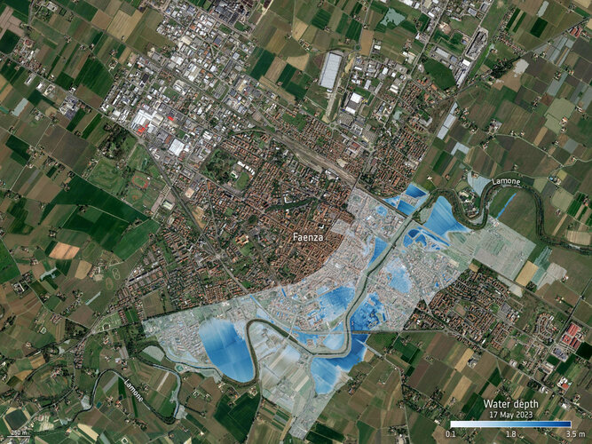
The Italian region of Emilia-Romagna was devastated by severe floods in May 2023, claiming lives and displacing thousands of people, resulting in an estimated €8.8 billion in damages. With the region still grappling with the aftermath, satellites have been instrumental in assessing the damages of the affected areas.
Meet us in Berlin, Germany | INTERGEO 2023
20.7.2023 11:25 Satlab GeosolutionsEvent: Meet us in Berlin, Germany | INTERGEO 2023 Date: 10–12 October 2023 INTERGEO conference […]
The post Meet us in Berlin, Germany | INTERGEO 2023 appeared first on Global Satellite Positioning Solutions | SatLab Geosolutions AB.
Free Ticket To INTERGEO 2023 | See You There
20.7.2023 11:25 Satlab GeosolutionsEvent: Meet us in Berlin, Germany | INTERGEO 2023 Date: 10–12 October 2023 INTERGEO conference […]
The post Free Ticket To INTERGEO 2023 | See You There appeared first on Global Satellite Positioning Solutions | SatLab Geosolutions AB.
20230720 - volné místo – Vedoucí OPV k nemovitostem KP Litoměřice na KÚ pro Ústecký kraj
19.7.2023 14:18 ČÚZK /Urady/Katastralni-urady/Katastralni-urady/Katastralni-urad-pro-Ustecky-kraj/Katastralni-pracoviste/KP-Litomerice/O-uradu/Aktuality/20230720-volne-misto-–-Vedouci-OPV-k-nemovitostem20230720 - volné místo – Vedoucí OPV k nemovitostem KP Litoměřice na KÚ pro Ústecký kraj
19.7.2023 14:18 ČÚZK - předpisy a opatření Katastrální úřad pro Ústecký kraj - Katastrální pracoviště Litoměřice zveřejnil novou aktualitu: Nabídka volného místa představeného - Vedoucí oddělení právních vztahů k nemovitostem Katastrálního pracoviště Litoměřice na Katastrálním úřadu pro Ústecký kraj20230720 - volné místo – Vedoucí OPV k nemovitostem KP Litoměřice na KÚ pro Ústecký kraj
19.7.2023 14:18 ČÚZK - předpisy a opatření Katastrální úřad pro Ústecký kraj - Katastrální pracoviště Litoměřice zveřejnil novou aktualitu: Nabídka volného místa představeného - Vedoucí oddělení právních vztahů k nemovitostem Katastrálního pracoviště Litoměřice na Katastrálním úřadu pro Ústecký kraj20230720 - volné místo – Vedoucí OPV k nemovitostem KP Litoměřice na KÚ pro Ústecký kraj
19.7.2023 14:18 ČÚZK /Urady/Katastralni-urady/Katastralni-urady/Katastralni-urad-pro-Ustecky-kraj/O-uradu/Aktuality/20230720-volne-misto-–-Vedouci-OPV-k-nemovitostem-Vedoucí oddělení právních vztahů k nemovitostem Katastrálního pracoviště Litoměřice na Katastrálním
19.7.2023 14:15 ČÚZK /Urady/Katastralni-urady/Katastralni-urady/Katastralni-urad-pro-Ustecky-kraj/Uredni-deska/Oznameni-a-jina-uredni-sdeleni/Volna-mista/DMS/Vedouci-oddeleni-pravnich-vztahu-k-nemovitostem-KaVedoucí oddělení právních vztahů k nemovitostem Katastrálního pracoviště Litoměřice na Katastrálním
19.7.2023 14:15 ČÚZK - předpisy a opatření Katastrální úřad pro Ústecký kraj Katastrální pracoviště Litoměřicevypisuje výběrové řízení na místo
Vedoucí oddělení právních vztahů k nemovitostem Katastrálního pracoviště Litoměřice na Katastrálním úřadu pro Ústecký kraj
Vedoucí oddělení právních vztahů k nemovitostem Katastrálního pracoviště Litoměřice na Katastrálním
19.7.2023 14:15 ČÚZK - volná místa Katastrální úřad pro Ústecký kraj Katastrální pracoviště Litoměřice vypisuje výběrové řízení na místo Vedoucí oddělení právních vztahů k nemovitostem Katastrálního pracoviště Litoměřice na KatastrálnímReplay: Aeolus reentry media briefing
19.7.2023 14:00 ESA Observing the Earth Video:
00:45:00
Video:
00:45:00
After completing its mission in orbit, ESA’s wind mission Aeolus will soon reenter Earth's atmosphere. Currently orbiting 320 km above, Aeolus is being kept in orbit with its remaining fuel. This fuel is running out, and the satellite will soon succumb to Earth’s atmosphere and gravity.
Going above and beyond what the satellite was technically designed to do, ESA is attempting a first-of-its-kind assisted reentry to reduce the (already very small) risk of damage from any fragments that survive the journey and reach the ground.
ESA held an online media briefing on 19 July 2023 to explain more about this assisted approach and answer questions.
Replay: Aeolus reentry media briefing
19.7.2023 14:00 ESA Observing the Earth
Video:
00:40:24
After completing its mission in orbit, ESA’s wind mission Aeolus will soon reenter Earth's atmosphere. Currently orbiting 320 km above, Aeolus is being kept in orbit with its remaining fuel. This fuel is running out, and the satellite will soon succumb to Earth’s atmosphere and gravity.
Going above and beyond what the satellite was technically designed to do, ESA is attempting a first-of-its-kind assisted reentry to reduce the (already very small) risk of damage from any fragments that survive the journey and reach the ground.
ESA held an online media briefing on 19 July 2023 to explain more about this assisted approach and answer questions.
11. jednání TPS
19.7.2023 13:36 ČÚZK - předpisy a opatření Dne 30. srpna 2023 proběhne distančně 11. jednání Technické pracovní skupiny Koordinační rady správců DMVS a DTM.29. jednání KRS
19.7.2023 13:34 ČÚZK - předpisy a opatření Dne 23. srpna 2023 proběhne distančně 29. jednání Koordinační rady správců DMVS a DTM.Verze 1.5.2.3 na INT1
19.7.2023 12:02 ČÚZK - předpisy a opatření Český úřad zeměměřický a katastrální informuje, že dne 18. července 2023 byla na integrační prostředí INT1 IS DMVS nainstalována nové verze 1.5.2.3 informačního systému. Tato verze již v odpovědi WS R9 a R13a vrací seznam dvojic identifikátorů vložených prvků a je shodná s verzí nasazenou na produkčním prostředí IS DMVS.Využijte letní slevu 30 % na BIM vzdělávání
19.7.2023 9:57 Arkance SystemsE-learning Autodesk Civil 3D a Autodesk Revit a kniha Stavařův průvodce Revitem v akci až do 5. srpna 2023.
Zpráva Využijte letní slevu 30 % na BIM vzdělávání pochází z arkance-systems.cz.
Využijte letní slevu 30 % na BIM vzdělávání
19.7.2023 9:57 Arkance SystemsE-learning Autodesk Civil 3D a Autodesk Revit a kniha Stavařův průvodce Revitem v akci až do 5. srpna 2023.
Zpráva Využijte letní slevu 30 % na BIM vzdělávání pochází z arkance-systems.cz.
LiDAR Data Visualization – School in Japan
19.7.2023 5:28 Satlab GeosolutionsThe visualization of LiDAR data shows school buildings in Japan. Short production times are […]
The post LiDAR Data Visualization – School in Japan appeared first on Global Satellite Positioning Solutions | SatLab Geosolutions AB.
Od července 2023 jsme členy CAGI!!!
18.7.2023 18:30 3gon ‼️Naše společnost se od července 2023 stala kolektivním členem České asociace pro geoinformace (CAGI). Děkujeme za přijetí a doufáme v
Video - Jak vytvořit PDF/A soubor s kombinací formátů A3 a A4
18.7.2023 13:16 GEUSware K vytvoření PDF/A soubor s kombinací formátů A3 a A4 lze použít PDF Creator. Jak na to naleznete v našem videu.New strategy to keep pace with our changing world
18.7.2023 12:03 ESA Observing the Earth
Fuelled largely by climate change, our planet is being subjected to environmental changes that are having an unprecedented global impact on humans, animals and plants. Shockingly, in certain locations these changes are occurring at a rate never before witnessed.
To keep pace with the challenges we face, ESA is embarking on a new Earth observation science strategy – and has reached out to the scientific community at this early stage in the process to help guide the Agency’s scientific agenda for the coming years.
ZABAGED® - aktualizace
18.7.2023 11:54 ČÚZK - Geoportál ZABAGED® - aktualizaceZačátkem července 2023 byly zpřístupněny uživatelům zaktualizované sady těchto typů objektů ZABAGED®: definiční body adresních míst, hranice správních jednotek a katastrálních území společně s definičními body správních celků, včetně aktualizace státní hranice, železniční tratě a vlečky, železniční stanice a zastávky včetně jejich areálů, evidované silnice a dálnice a prvky ležící na nich – křižovatky úrovňové a mimoúrovňové, mosty, podjezdy, tunely, parkoviště, odpočívky a uzlové body silniční sítě, elektrárny, větrné motory, přenosové elektrické vedení, zábrany. Dále byly aktualizovány cesty a pěšiny včetně jejich povrchů. Průběžně byly během celého období aktualizovány definiční čáry ulic podle návrhu obcí současně s definičními body náměstí.
V 2. čtvrtletí 2023 byla dokončena plošná aktualizace ZABAGED® na celém území mapových listů Základní topografické mapy ČR 1:50 000: 0203-D, 0204-C, 0302-B, 0302-D, 0303-B, 0304-B, 0406-A, 0409-D, 0509-B, 0604-C, 0607-B, 0704-A.
V 2. čtvrtletí 2023 byly v rámci aktualizace stavebních objektů v ZABAGED® (na podkladě existující kresby v ISKN, Ortofota ČR, výstupů z dat leteckého laserového skenování a dalších dostupných zdrojů) aktualizovány budovy a další stavební objekty v okresech: Brno-město, Děčín, Hlavní město Praha, Hodonín, Cheb, Jičín, Karviná, Kroměříž, Kutná Hora, Litoměřice, Pardubice, Pelhřimov, Plzeň-sever, Praha-západ, Přerov, Příbram, Rokycany, Strakonice, Tábor, Tachov, Uherské Hradiště, Vsetín, Zlín.
Více informací o stavu aktualizace je uvedeno v tabulce Informace o produktu, v oddíle Aktualizační cyklus - stav aktualizace.
rada/odborný rada v právním oddělení na Katastrálním pracovišti Brno-venkov
18.7.2023 11:13 ČÚZK /Urady/Katastralni-urady/Katastralni-urady/Katastralni-urad-pro-Jihomoravsky-kraj/Uredni-deska/Oznameni-a-jina-uredni-sdeleni/Volna-mista/DMS/rada-odborny-rada-v-pravnim-oddeleni-na-Katastralnrada/odborný rada v právním oddělení na Katastrálním pracovišti Brno-venkov
18.7.2023 11:13 ČÚZK - volná místa Katastrální úřad pro Jihomoravský kraj Katastrální pracoviště Brno-venkov vypisuje výběrové řízení na místo rada/odborný rada v právním oddělení na Katastrálním pracovišti Brno-venkovrada/odborný rada v právním oddělení na Katastrálním pracovišti Brno-venkov
18.7.2023 11:13 ČÚZK - předpisy a opatření Katastrální úřad pro Jihomoravský kraj Katastrální pracoviště Brno-venkovvypisuje výběrové řízení na místo
rada/odborný rada v právním oddělení na Katastrálním pracovišti Brno-venkov
Nové číslo GaKO
18.7.2023 8:50
ÚGKK SR
Nové číslo časopisu Geodetického a Kartografického Obzoru 07/2023
Oznámení o vyhlášení VŘ na služební místo rada-odborný rada (VŘ 5)
18.7.2023 7:59 ČÚZK - předpisy a opatření Zeměměřický a katastrální inspektorát v Praze zveřejnil novou aktualitu: Zeměměřický a katastrální inspektorát v Praze vyhlašuje výběrové řízení na služební místo Rada/Odborný rada inspektor (obor služby 55)Oznámení o vyhlášení VŘ na služební místo rada-odborný rada (VŘ 5)
18.7.2023 7:59 ČÚZK /Urady/Zememericke-a-katastralni-inspektoraty/Zememericke-a-katastralni-inspektoraty/Zememericky-a-katastralni-inspektorat-v-Praze/O-uradu/Aktuality/Oznameni-o-vyhlaseni-VR-na-sluzebni-misto-rada-(4)Oznámení o vyhlášení VŘ na služební místo rada - odborný rada (VŘ 4)
18.7.2023 7:50 ČÚZK - předpisy a opatření Zeměměřický a katastrální inspektorát v Praze zveřejnil novou aktualitu: Zeměměřický a katastrální inspektorát v Praze vyhlašuje výběrové řízení na služební místo Rada/Odborný rada inspektor (obor služby 55)Oznámení o vyhlášení VŘ na služební místo rada - odborný rada (VŘ 4)
18.7.2023 7:50 ČÚZK /Urady/Zememericke-a-katastralni-inspektoraty/Zememericke-a-katastralni-inspektoraty/Zememericky-a-katastralni-inspektorat-v-Praze/O-uradu/Aktuality/Oznameni-o-vyhlaseni-VR-na-sluzebni-misto-rada-(3)Rada/odborný rada - inspektor ZKI v Praze (obor služby 55.)
18.7.2023 7:44 ČÚZK /Urady/Zememericke-a-katastralni-inspektoraty/Zememericke-a-katastralni-inspektoraty/Zememericky-a-katastralni-inspektorat-v-Praze/Uredni-deska/Oznameni-a-jina-uredni-sdeleni/Volna-mista/DMS/Rada-odborny-rada-inspektor-ZKI-v-Praze-(obor-(1)Rada/odborný rada - inspektor ZKI v Praze (obor služby 55.)
18.7.2023 7:44 ČÚZK - předpisy a opatření Zeměměřický a katastrální inspektorát v Prazevypisuje výběrové řízení na místo
Rada/odborný rada - inspektor ZKI v Praze (obor služby 55.)
Rada/odborný rada - inspektor ZKI v Praze (obor služby 55.)
18.7.2023 7:44 ČÚZK - volná místa Zeměměřický a katastrální inspektorát v Praze vypisuje výběrové řízení na místo Rada/odborný rada - inspektor ZKI v Praze (obor služby 55.)Rada/odborný rada- inspektor ZKI v Praze (obor služby 55.)
18.7.2023 7:44 ČÚZK - volná místa Zeměměřický a katastrální inspektorát v Praze vypisuje výběrové řízení na místo Rada/odborný rada- inspektor ZKI v Praze (obor služby 55.)Rada/odborný rada- inspektor ZKI v Praze (obor služby 55.)
18.7.2023 7:44 ČÚZK /Urady/Zememericke-a-katastralni-inspektoraty/Zememericke-a-katastralni-inspektoraty/Zememericky-a-katastralni-inspektorat-v-Praze/Uredni-deska/Oznameni-a-jina-uredni-sdeleni/Volna-mista/DMS/Rada-odborny-rada-inspektor-ZKI-v-Praze-(obor-sluzRada/odborný rada- inspektor ZKI v Praze (obor služby 55.)
18.7.2023 7:44 ČÚZK - předpisy a opatření Zeměměřický a katastrální inspektorát v Prazevypisuje výběrové řízení na místo
Rada/odborný rada - inspektor ZKI v Praze (obor služby 55.)
Výběrové řízení na pozici odborný / vrchní referent v oddělení aktualizace katastru nemovitostí Kata
18.7.2023 6:41 ČÚZK - volná místa Katastrální úřad pro Královéhradecký kraj Katastrální pracoviště Trutnov vypisuje výběrové řízení na místo Výběrové řízení na pozici odborný / vrchní referent v oddělení aktualizace katastru nemovitostí KataVýběrové řízení na pozici odborný / vrchní referent v oddělení aktualizace katastru nemovitostí Kata
18.7.2023 6:41 ČÚZK - předpisy a opatření Katastrální úřad pro Královéhradecký kraj Katastrální pracoviště Trutnovvypisuje výběrové řízení na místo
Výběrové řízení na pozici odborný / vrchní referent v oddělení aktualizace katastru nemovitostí Katastrálního pracoviště Trutnov
Letní nabídka AGACAD modulů pro Autodesk Revit
18.7.2023 0:00 Arkance SystemsZískejte 6 měsíců navíc při koupi ročního předplatného modulů AGACAD pro Autodesk Revit. Nabídka platí do 18. srpna 2023.
Zpráva Letní nabídka AGACAD modulů pro Autodesk Revit pochází z arkance-systems.cz.
Časopis Fórum sociální politiky online [Knihovna geografie, byTopic]
18.7.2023 0:00 Katedra aplikované geoinformatiky a kartografie Přf UK Upozornění čtenářům - časopis Fórum sociální politiky bude vycházet od čísla 3/2023 pouze v elektronické podobě. Volně ke stažení bude na www.rilsa.cz/casopis-fsp/.rada/odborný rada - inspektor ZKI v Liberci
17.7.2023 15:51 ČÚZK - předpisy a opatření Zeměměřický a katastrální inspektorát v Libercivypisuje výběrové řízení na místo
rada/odborný rada - inspektor ZKI v Liberci
rada/odborný rada - inspektor ZKI v Liberci
17.7.2023 15:51 ČÚZK /Urady/Zememericke-a-katastralni-inspektoraty/Zememericke-a-katastralni-inspektoraty/Zememericky-a-katastralni-inspektorat-v-Liberci/Uredni-deska/Oznameni-a-jina-uredni-sdeleni/Volna-mista/DMS/Oznameni-o-vyhlaseni-VRrada/odborný rada - inspektor ZKI v Liberci
17.7.2023 15:51 ČÚZK - volná místa Zeměměřický a katastrální inspektorát v Liberci vypisuje výběrové řízení na místo rada/odborný rada - inspektor ZKI v LiberciPřerušení provozu DP a WSDP ve čtvrtek 20.7.2023 od 16:30 do cca 22:00.
17.7.2023 15:17 ČÚZK - předpisy a opatření Vážení uživatelé,oznamujeme, že ve čtvrtek 20.7.2023 od 16:30 bude z provozních důvodů zcela přerušen provoz Dálkového přístupu i Webových služeb dálkového přístupu. Obnovení provozu předpokládáme v cca 22 hodin. U této akce nedochází ke změnám webových služeb.
Za komplikace tímto způsobené se omlouváme a děkujeme za pochopení.
Přerušení provozu DP a WSDP ve čtvrtek 20.7.2023 od 16:30 do cca 22:00.
17.7.2023 15:17 ČÚZK /Aplikace-DP-do-KN/Aplikace-DP-do-KN/Archiv-DP/390489Přerušení provozu DP a WSDP ve čtvrtek 20.7.2023 od 16:30 do cca 22:00.
17.7.2023 15:17 Dálkový přístup k údajům KN ČR Vážení uživatelé,oznamujeme, že ve čtvrtek 20.7.2023 od 16:30 bude z provozních důvodů zcela přerušen provoz Dálkového přístupu i Webových služeb dálkového přístupu. Obnovení provozu předpokládáme v cca 22 hodin. U této akce nedochází ke změnám webových služeb.
Za komplikace tímto způsobené se omlouváme a děkujeme za pochopení.
EU Space technologies and development tools revolutionize archaeological research
17.7.2023 14:24 European GNSS Agency
Just as Indiana Jones captivates audiences with his new adventures, EU Space technologies captivate modern archaeologists, offering new possibilities for exploration and discovery in the field of archaeology.
Modern archaeologists have made GNSS and Earth Observation their tools of choice.
Take for example GNSS, which has emerged as the tool of trade for many archaeological projects. “Before GNSS, the archaeological excavation process was both cumbersome, hands-on and physically demanding,” Shane McCartney, a consultant archaeologist at Earthworks Archaeological Services Inc., tells XY Ht magazine. “We’d be out in the field with 50-metre tapes and pen and paper in hand trying to triangulate, grid and count off the number of paces from such reference points as ‘the big pine tree next to the fence.’”
Not only is this process very slow, it’s also prone to error. That’s why archaeologists have largely ditched the tape and paper and instead rely on the precise positioning provided by GNSS. Using Galileo, Europe’s GNSS programme, they can now quickly survey a field site, accurately map the location of any uncovered artefacts and compile all the data into an easy-to-use GIS system.
EO to the rescue
The role of EU Space in archaeology doesn’t end with the excavation. After all, once an artefact or site is uncovered, it then needs to be preserved – something that’s becoming all the more challenging due to climate change. In fact, it’s estimated that as much as 5% of our 1,121 UNESCO World Heritage sites are in danger and in need of increased protection.
Here too, EU Space can help.
For instance, in Rhodes, archaeologists are using Earth Observation data provided by Copernicus Land Monitoring Service (CLMS) to monitor the impact settlement pressure is having on the island’s cultural heritage sites.
Founded in 408 B.C., the area’s rich history is still very much visible today – including parts of the ancient necropolis, monumental graves, cave sanctuaries and a Roman bridge. Unfortunately, all this important cultural heritage is being threatened by the island’s constantly shifting soil.
As part of the pan-European component of the CLMS, the European Ground Motion Service (EGMS) provides an unprecedented opportunity to study geohazards and human-induced deformation such as slow-moving landslides, subsidence due to groundwater exploitation or underground mining, volcanic unrests and many more. The EGMS also serves as a starting point for investigation of ground motion affecting buildings and linear infrastructures.
“To prevent further damage to the monuments and adopt effective conservation measures, we need accurate and up-to-date information on land deformation,” says Sotiris Patatoukos, Head of the Department of Conservation, Ephorate of Antiquities of the Dodecanese, in this video produced by Eurisy.
With the support of the EU-funded HYPERION project, authorities in Rhodes are using Copernicus data to better understand land movement and how such movement is impacting various archaeological sites. After collecting more than 100 images between 2016 and 2019, researchers discovered that the area around the Rodini cultural site had experienced a 10 mm uplift. With this information in hand, archaeologists were able to take action to stabilise the most threatened monuments.
“Facilitating the early recognition of potential risks to the monuments and allowing us to regularly monitor land deformation in the area, Copernicus is an essential tool for preserving our cultural heritage,” Vassiliki Patsiada, an archaeologist at the Ephorate of Antiquities of the Dodecanese, tells Eurisy.
So, when you’re out exploring Europe’s plethora of cultural heritage sights this summer, remember, while fedoras look great for selfies in front of the Colosseum or Acropolis, its EU Space that’s working to preserve those iconic backdrops.
Media note: This feature can be republished without charge provided the European Union Agency for the Space Programme (EUSPA) is acknowledged as the source at the top or the bottom of the story. You must request permission before you use any of the photographs on the site. If you republish, we would be grateful if you could link back to the EUSPA website (http://www.euspa.europa.eu).
Nedostupnost WSDP na zkoušku ve dnech 20.7. - 28.7.2023
17.7.2023 14:22 ČÚZK /Aplikace-DP-do-KN/Aplikace-DP-do-KN/Archiv-DP/390477Nedostupnost WSDP na zkoušku ve dnech 20.7. - 28.7.2023
17.7.2023 14:22 ČÚZK - předpisy a opatření Vážení uživatelé webových služeb,oznamujeme, že z technických důvodů nebudou ve dnech od 20.7.2023 do 28.7.2023 dostupné webové služby dálkového přístupu na zkoušku.
Za komplikace se omlouváme a děkujeme za pochopení.
Nedostupnost WSDP na zkoušku ve dnech 20.7. - 28.7.2023
17.7.2023 14:22 Dálkový přístup k údajům KN ČR Vážení uživatelé webových služeb,oznamujeme, že z technických důvodů nebudou ve dnech od 20.7.2023 do 28.7.2023 dostupné webové služby dálkového přístupu na zkoušku.
Za komplikace se omlouváme a děkujeme za pochopení.
výběrové řízení na KP Žďár nad Sázavou
17.7.2023 10:56 ČÚZK - předpisy a opatření Katastrální úřad pro Vysočinu - Katastrální pracoviště Žďár nad Sázavou zveřejnil novou aktualitu: Oznámení o vyhlášení výběrového řízení na služební místo rada/odborný rada v oddělení aktualizace KN Katastrálního pracoviště Žďár nad Sázavou.rada-odborný rada - aktualizace KN KP Žďár n. Sázavou
17.7.2023 10:36 ČÚZK - volná místa Katastrální úřad pro Vysočinu Katastrální pracoviště Žďár nad Sázavou vypisuje výběrové řízení na místo rada-odborný rada - aktualizace KN KP Žďár n. Sázavourada-odborný rada - aktualizace KN KP Žďár n. Sázavou
17.7.2023 10:36 ČÚZK - předpisy a opatření Katastrální úřad pro Vysočinu Katastrální pracoviště Žďár nad Sázavouvypisuje výběrové řízení na místo
rada-odborný rada - aktualizace KN KP Žďár n. Sázavou
rada-odborný rada - aktualizace KN KP Žďár n. Sázavou
17.7.2023 10:36 ČÚZK /Urady/Katastralni-urady/Katastralni-urady/Katastralni-urad-pro-Vysocinu/Uredni-deska/Oznameni-a-jina-uredni-sdeleni/Volna-mista/DMS/rada-odborny-rada-aktualizace-KN-KP-Zdar-n-SazavouTurboCAD Designer + TurboPDF v akční ceně
15.7.2023 19:29 ŠPINAR - softwareVážení zákazníci,
máme pro Vás připravené programy TurboCAD Designer 28 CZ + TurboPDF CZ, které spojují CAD nástroje pro kreslení ve 2D / 3D prostoru včetně fotorealistických výstupů s editorem a převodníkem PDF dokumentů v akční ceně do 23. 07. 2023.
TurboCAD Designer + TurboPDF v akční ceně
15.7.2023 19:29 ŠPINAR - softwareVážení zákazníci,
máme pro Vás připravené programy TurboCAD Designer 28 CZ + TurboPDF CZ, které spojují CAD nástroje pro kreslení ve 2D / 3D prostoru včetně fotorealistických výstupů s editorem a převodníkem PDF dokumentů v akční ceně do 23. 07. 2023.
The post TurboCAD Designer + TurboPDF v akční ceně appeared first on ŠPINAR – software.
openBIM®: what is it and why do we need it?
14.7.2023 18:38 buildingSMART.orgBlog one in a series of three. This is the first in a series of three blogs that explore: ① what is openBIM and why is it so important; ②…
The post openBIM®: what is it and why do we need it? appeared first on buildingSMART International.
Krátka správa č. 30/2023
14.7.2023 11:18 Komora geodetů a kartografů SRThe post Krátka správa č. 30/2023 appeared first on Komora geodetov a kartografov.
The sound of Aeolus will blow you away
14.7.2023 11:00 ESA Observing the Earth
After almost five years, ESA’s Aeolus wind satellite has completed its mission. Now, you can listen to the Life of Aeolus – an incredible wind orchestral piece that has been composed using data spanning Aeolus’ entire life in orbit around Earth.
Earth from Space: Ethiopian painting
14.7.2023 10:00 ESA Observing the Earth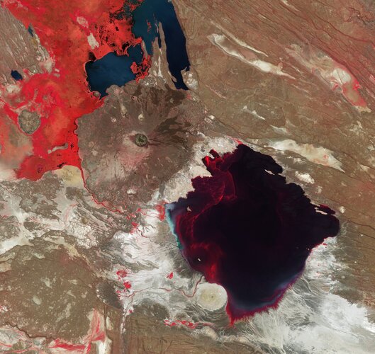 Image:
Reminiscent of an artist’s pallet, this striking false-colour image captured by the Copernicus Sentinel-2 mission features Lake Abbe in northeast Ethiopia.
Image:
Reminiscent of an artist’s pallet, this striking false-colour image captured by the Copernicus Sentinel-2 mission features Lake Abbe in northeast Ethiopia.
GaKO 7/2023
14.7.2023 7:45 GaKO GaKO 7/2023 ŠENKEŘÍK, J.–BEITLOVÁ, M.: Uživatelské hodnocení hodnotových měřítek školních atlasů světa VILÁŠEK, M.: Měření vzdáleností ve vesmíruThe SpatialZone Final Technical report is with the Standards Committee for review prior to its publicaton.
13.7.2023 20:00 buildingSMART.orgPlease click the link to view the final technical report. Go to document
The post The SpatialZone Final Technical report is with the Standards Committee for review prior to its publicaton. appeared first on buildingSMART International.
Nové sestavení GEUS 27.0 a uvolnění GEUS 28.0
13.7.2023 16:31 GEUSware Byla uvolněna nová verze programu GEUS 28.0. Hlavním důvodem nové verze je použití kompletně jiného databázového systému SQLite pro práci s daty ISKN. Pokud máte zakoupenou licenční podporu programu GEUS pro rok 2023, můžete novou verzi 28.0 začít okamžitě používat.Zároveň s tím bylo uvolněno i nové sestavení GEUS 27.0, které nadále používá původní databázový systém FlashFiler. Pokud jste verzi 27.0 zakoupili jako UPGRADE (nemáte předplacenou licenční podporu), můžete nadále používat verzi 27.0, jejíž podpora bude ukončena jako každý rok 30. listopadu 2023 a verzi 28.0 můžete zakoupit, až to budete potřebovat.
Obě verze programu obsahují možnost kontroly souborů PDF před jejich podepsáním, zda jsou v nyní požadovaném formátu PDF/A-2b a výše. Více informací v článku.
Návod pro registraci obcí a pro lokální administrátory
13.7.2023 16:30 ČÚZK - předpisy a opatření V záložce Portál DMVS byly zveřejněny další návody: Návod pro registraci obcí a dalších OVMDočasný nárůst změnových souborů VFR
13.7.2023 15:43 ČÚZK /ruian/Poskytovani-udaju-ISUI-RUIAN-VDP/Vymenny-format-RUIAN-(VFR)/Archiv-novinek-VFR/2023/Docasny-narust-zmenovych-souboru-VFRDočasný nárůst změnových souborů VFR
13.7.2023 15:43 ČÚZK /ruian/Poskytovani-udaju-ISUI-RUIAN-VDP/Vymenny-format-RUIAN-(VFR)/Archiv-novinek-VFR/2022/Docasny-narust-zmenovych-souboru-VFRVrchní referent / rada – návrh zápisu v katastru v oddělení aktualizace KN Katastrálního pracoviště
13.7.2023 13:27 ČÚZK /Urady/Katastralni-urady/Katastralni-urady/Katastralni-urad-pro-Zlinsky-kraj/Uredni-deska/Oznameni-a-jina-uredni-sdeleni/Volna-mista/DMS/Vrchni-referent-rada-–-navrh-zapisu-v-katastru-v-oVrchní referent / rada – návrh zápisu v katastru v oddělení aktualizace KN Katastrálního pracoviště
13.7.2023 13:27 ČÚZK - volná místa Katastrální úřad pro Zlínský kraj Katastrální pracoviště Zlín vypisuje výběrové řízení na místo Vrchní referent / rada – návrh zápisu v katastru v oddělení aktualizace KN Katastrálního pracovištěVrchní referent / rada – návrh zápisu v katastru v oddělení aktualizace KN Katastrálního pracoviště
13.7.2023 13:27 ČÚZK - předpisy a opatření Katastrální úřad pro Zlínský kraj Katastrální pracoviště Zlínvypisuje výběrové řízení na místo
Vrchní referent / rada – návrh zápisu v katastru v oddělení aktualizace KN Katastrálního pracoviště Zlín