


![]()

zprávy
zdroje zpráv:vrchní referent/rada – obnova katastrálního operátu na Katastrálním pracovišti Frýdek-Místek Katastr
28.12.2022 8:45 ČÚZK /Urady/Katastralni-urady/Katastralni-urady/Katastralni-urad-pro-Moravskoslezsky-kraj/Uredni-deska/Oznameni-a-jina-uredni-sdeleni/Volna-mista/DMS/vrchni-referent-rada-–-obnova-katastralniho-op-(2)vrchní referent/rada – obnova katastrálního operátu na Ka
28.12.2022 8:45 ČÚZK - volná místa Katastrální úřad pro Moravskoslezský kraj Katastrální pracoviště Frýdek-Místek vypisuje výběrové řízení na místo vrchní referent/rada – obnova katastrálního operátu na Kavrchní referent/rada – obnova katastrálního operátu na Katastrálním pracovišti Frýdek-Místek Katastr
28.12.2022 8:45 ČÚZK - předpisy a opatření Katastrální úřad pro Moravskoslezský kraj - Katastrální pracoviště Frýdek-Místekvypisuje výběrové řízení na místo
vrchní referent/rada – obnova katastrálního operátu na Katastrálním pracovišti Frýdek-Místek Katastrálního úřadu pro Moravskoslezský kraj
vrchní referent/rada – obnova katastrálního operátu na Katastrálním pracovišti Frýdek-Místek Katastr
28.12.2022 8:45 ČÚZK - volná místa Katastrální úřad pro Moravskoslezský kraj - Katastrální pracoviště Frýdek-Místek vypisuje výběrové řízení na místo vrchní referent/rada – obnova katastrálního operátu na Katastrálním pracovišti Frýdek-Místek Katastrrada/odborný rada – řízení o opravě chyby v SPI na Katast
28.12.2022 8:43 ČÚZK - volná místa Katastrální úřad pro Moravskoslezský kraj Katastrální pracoviště Frýdek-Místek vypisuje výběrové řízení na místo rada/odborný rada – řízení o opravě chyby v SPI na Katastrada/odborný rada – řízení o opravě chyby v SPI na Katastrálním pracovišti Frýdek-Místek Katastrální
28.12.2022 8:43 ČÚZK - volná místa Katastrální úřad pro Moravskoslezský kraj - Katastrální pracoviště Frýdek-Místek vypisuje výběrové řízení na místo rada/odborný rada – řízení o opravě chyby v SPI na Katastrálním pracovišti Frýdek-Místek Katastrálnírada/odborný rada – řízení o opravě chyby v SPI na Katastrálním pracovišti Frýdek-Místek Katastrální
28.12.2022 8:43 ČÚZK - předpisy a opatření Katastrální úřad pro Moravskoslezský kraj - Katastrální pracoviště Frýdek-Místekvypisuje výběrové řízení na místo
rada/odborný rada – řízení o opravě chyby v SPI na Katastrálním pracovišti Frýdek-Místek Katastrálního úřadu pro Moravskoslezský kraj
rada/odborný rada – řízení o opravě chyby v SPI na Katast
28.12.2022 8:43 ČÚZK - předpisy a opatření Katastrální úřad pro Moravskoslezský kraj - Katastrální pracoviště Frýdek-Místekvypisuje výběrové řízení na místo
rada/odborný rada – řízení o opravě chyby v SPI na Katastrálním pracovišti Frýdek-Místek Katastrálního úřadu pro Moravskoslezský kraj
rada/odborný rada – řízení o opravě chyby v SPI na Katastrálním pracovišti Frýdek-Místek Katastrální
28.12.2022 8:43 ČÚZK /Urady/Katastralni-urady/Katastralni-urady/Katastralni-urad-pro-Moravskoslezsky-kraj/Uredni-deska/Oznameni-a-jina-uredni-sdeleni/Volna-mista/DMS/rada-odborny-rada-–-rizeni-o-oprave-chyby-v-SPI-narada/odborný rada – řízení o opravě chyby v SPI na Katast
28.12.2022 8:43 ČÚZK /Urady/Katastralni-urady/Katastralni-urady/Katastralni-urad-pro-Moravskoslezsky-kraj/Uredni-deska/Oznameni-a-jina-uredni-sdeleni/Volna-mista/DMS/rada-odborny-rada-–-rizeni-o-oprave-chyby-v-SPI-navrchní referent/rada – vedení katastrální mapy na Katastrálním pracovišti Frýdek-Místek Katastrálníh
28.12.2022 8:42 ČÚZK - předpisy a opatření Katastrální úřad pro Moravskoslezský kraj - Katastrální pracoviště Frýdek-Místekvypisuje výběrové řízení na místo
vrchní referent/rada – vedení katastrální mapy na Katastrálním pracovišti Frýdek-Místek Katastrálního úřadu pro Moravskoslezský kraj
vrchní referent/rada – vedení katastrální mapy na Katastrálním pracovišti Frýdek-Místek Katastráln
28.12.2022 8:42 ČÚZK /Urady/Katastralni-urady/Katastralni-urady/Katastralni-urad-pro-Moravskoslezsky-kraj/Uredni-deska/Oznameni-a-jina-uredni-sdeleni/Volna-mista/DMS/vrchni-referent-rada-–-vedeni-katastralni-mapy-navrchní referent/rada – vedení katastrální mapy na Katastrálním pracovišti Frýdek-Místek Katastráln
28.12.2022 8:42 ČÚZK - předpisy a opatření Katastrální úřad pro Moravskoslezský kraj - Katastrální pracoviště Frýdek-Místekvypisuje výběrové řízení na místo
vrchní referent/rada – vedení katastrální mapy na Katastrálním pracovišti Frýdek-Místek Katastrálního úřadu pro Moravskoslezský kraj
vrchní referent/rada – vedení katastrální mapy na Katastrálním pracovišti Frýdek-Místek Katastrálníh
28.12.2022 8:42 ČÚZK - volná místa Katastrální úřad pro Moravskoslezský kraj - Katastrální pracoviště Frýdek-Místek vypisuje výběrové řízení na místo vrchní referent/rada – vedení katastrální mapy na Katastrálním pracovišti Frýdek-Místek Katastrálníhvrchní referent/rada – vedení katastrální mapy na Katastrálním pracovišti Frýdek-Místek Katastráln
28.12.2022 8:42 ČÚZK - předpisy a opatření Katastrální úřad pro Moravskoslezský kraj Katastrální pracoviště Frýdek-Místekvypisuje výběrové řízení na místo
vrchní referent/rada – vedení katastrální mapy na Katastrálním pracovišti Frýdek-Místek Katastrálního úřadu pro Moravskoslezský kraj
vrchní referent/rada – vedení katastrální mapy na Katastrálním pracovišti Frýdek-Místek Katastráln
28.12.2022 8:42 ČÚZK - volná místa Katastrální úřad pro Moravskoslezský kraj Katastrální pracoviště Frýdek-Místek vypisuje výběrové řízení na místo vrchní referent/rada – vedení katastrální mapy na Katastrálním pracovišti Frýdek-Místek Katastrálnvrchní referent/rada – vedení katastrální mapy na Katastrálním pracovišti Frýdek-Místek Katastrálníh
28.12.2022 8:42 ČÚZK /Urady/Katastralni-urady/Katastralni-urady/Katastralni-urad-pro-Moravskoslezsky-kraj/Uredni-deska/Oznameni-a-jina-uredni-sdeleni/Volna-mista/DMS/vrchni-referent-rada-–-vedeni-katastralni-mapy-navrchní referent/rada – vedení katastrální mapy na Katastrálním pracovišti Frýdek-Místek Katastráln
28.12.2022 8:42 ČÚZK /Urady/Katastralni-urady/Katastralni-urady/Katastralni-urad-pro-Moravskoslezsky-kraj/Uredni-deska/Oznameni-a-jina-uredni-sdeleni/Volna-mista/DMS/vrchni-referent-rada-–-vedeni-katastralni-mapy-na-vrchní referent/rada – vedení katastrální mapy na Katastrálním pracovišti Frýdek-Místek Katastráln
28.12.2022 8:42 ČÚZK - volná místa Katastrální úřad pro Moravskoslezský kraj - Katastrální pracoviště Frýdek-Místek vypisuje výběrové řízení na místo vrchní referent/rada – vedení katastrální mapy na Katastrálním pracovišti Frýdek-Místek Katastrálnodborný referent – obnova katastrálního operátu na Katastrálním pracovišti Bruntál Katastrálního úřa
28.12.2022 8:41 ČÚZK - volná místa Katastrální úřad pro Moravskoslezský kraj - Katastrální pracoviště Bruntál vypisuje výběrové řízení na místo odborný referent – obnova katastrálního operátu na Katastrálním pracovišti Bruntál Katastrálního úřaodborný referent – obnova katastrálního operátu na Katastrálním pracovišti Bruntál Katastrálního úř
28.12.2022 8:41 ČÚZK - předpisy a opatření Katastrální úřad pro Moravskoslezský kraj Katastrální pracoviště Bruntálvypisuje výběrové řízení na místo
odborný referent – obnova katastrálního operátu na Katastrálním pracovišti Bruntál Katastrálního úřadu pro Moravskoslezský kraj
odborný referent – obnova katastrálního operátu na Katastrálním pracovišti Bruntál Katastrálního úř
28.12.2022 8:41 ČÚZK - předpisy a opatření Katastrální úřad pro Moravskoslezský kraj - Katastrální pracoviště Bruntálvypisuje výběrové řízení na místo
odborný referent – obnova katastrálního operátu na Katastrálním pracovišti Bruntál Katastrálního úřadu pro Moravskoslezský kraj
odborný referent – obnova katastrálního operátu na Katastrálním pracovišti Bruntál Katastrálního úřa
28.12.2022 8:41 ČÚZK /Urady/Katastralni-urady/Katastralni-urady/Katastralni-urad-pro-Moravskoslezsky-kraj/Uredni-deska/Oznameni-a-jina-uredni-sdeleni/Volna-mista/DMS/odborny-referent-–-obnova-katastralniho-operatu-naodborný referent – obnova katastrálního operátu na Katastrálním pracovišti Bruntál Katastrálního úřa
28.12.2022 8:41 ČÚZK - předpisy a opatření Katastrální úřad pro Moravskoslezský kraj - Katastrální pracoviště Bruntálvypisuje výběrové řízení na místo
odborný referent – obnova katastrálního operátu na Katastrálním pracovišti Bruntál Katastrálního úřadu pro Moravskoslezský kraj
odborný referent – obnova katastrálního operátu na Katastrálním pracovišti Bruntál Katastrálního úř
28.12.2022 8:41 ČÚZK /Urady/Katastralni-urady/Katastralni-urady/Katastralni-urad-pro-Moravskoslezsky-kraj/Uredni-deska/Oznameni-a-jina-uredni-sdeleni/Volna-mista/DMS/odborny-referent-–-obnova-katastralniho-operatu-naodborný referent – obnova katastrálního operátu na Katastrálním pracovišti Bruntál Katastrálního úř
28.12.2022 8:41 ČÚZK - volná místa Katastrální úřad pro Moravskoslezský kraj - Katastrální pracoviště Bruntál vypisuje výběrové řízení na místo odborný referent – obnova katastrálního operátu na Katastrálním pracovišti Bruntál Katastrálního úřodborný referent – obnova katastrálního operátu na Katastrálním pracovišti Bruntál Katastrálního úř
28.12.2022 8:41 ČÚZK - volná místa Katastrální úřad pro Moravskoslezský kraj Katastrální pracoviště Bruntál vypisuje výběrové řízení na místo odborný referent – obnova katastrálního operátu na Katastrálním pracovišti Bruntál Katastrálního úřvrchní referent/rada – obnova katastrálního operátu na Katastrálním pracovišti Bruntál Katastrálníh
28.12.2022 8:39 ČÚZK - volná místa Katastrální úřad pro Moravskoslezský kraj Katastrální pracoviště Bruntál vypisuje výběrové řízení na místo vrchní referent/rada – obnova katastrálního operátu na Katastrálním pracovišti Bruntál Katastrálníhvrchní referent/rada – obnova katastrálního operátu na Katastrálním pracovišti Bruntál Katastrálníh
28.12.2022 8:39 ČÚZK - předpisy a opatření Katastrální úřad pro Moravskoslezský kraj - Katastrální pracoviště Bruntálvypisuje výběrové řízení na místo
vrchní referent/rada – obnova katastrálního operátu na Katastrálním pracovišti Bruntál Katastrálního úřadu pro Moravskoslezský kraj
vrchní referent/rada – obnova katastrálního operátu na Katastrálním pracovišti Bruntál Katastrálníh
28.12.2022 8:39 ČÚZK - předpisy a opatření Katastrální úřad pro Moravskoslezský kraj Katastrální pracoviště Bruntálvypisuje výběrové řízení na místo
vrchní referent/rada – obnova katastrálního operátu na Katastrálním pracovišti Bruntál Katastrálního úřadu pro Moravskoslezský kraj
vrchní referent/rada – obnova katastrálního operátu na Katastrálním pracovišti Bruntál Katastrálního
28.12.2022 8:39 ČÚZK /Urady/Katastralni-urady/Katastralni-urady/Katastralni-urad-pro-Moravskoslezsky-kraj/Uredni-deska/Oznameni-a-jina-uredni-sdeleni/Volna-mista/DMS/vrchni-referent-rada-–-obnova-katastralniho-op-(1)vrchní referent/rada – obnova katastrálního operátu na Katastrálním pracovišti Bruntál Katastrálníh
28.12.2022 8:39 ČÚZK - volná místa Katastrální úřad pro Moravskoslezský kraj - Katastrální pracoviště Bruntál vypisuje výběrové řízení na místo vrchní referent/rada – obnova katastrálního operátu na Katastrálním pracovišti Bruntál Katastrálníhvrchní referent/rada – obnova katastrálního operátu na Katastrálním pracovišti Bruntál Katastrálního
28.12.2022 8:39 ČÚZK - volná místa Katastrální úřad pro Moravskoslezský kraj - Katastrální pracoviště Bruntál vypisuje výběrové řízení na místo vrchní referent/rada – obnova katastrálního operátu na Katastrálním pracovišti Bruntál Katastrálníhovrchní referent/rada – obnova katastrálního operátu na Katastrálním pracovišti Bruntál Katastrálníh
28.12.2022 8:39 ČÚZK /Urady/Katastralni-urady/Katastralni-urady/Katastralni-urad-pro-Moravskoslezsky-kraj/Uredni-deska/Oznameni-a-jina-uredni-sdeleni/Volna-mista/DMS/vrchni-referent-rada-–-obnova-katastralniho-op-(1)vrchní referent/rada – obnova katastrálního operátu na Katastrálním pracovišti Bruntál Katastrálního
28.12.2022 8:39 ČÚZK - předpisy a opatření Katastrální úřad pro Moravskoslezský kraj - Katastrální pracoviště Bruntálvypisuje výběrové řízení na místo
vrchní referent/rada – obnova katastrálního operátu na Katastrálním pracovišti Bruntál Katastrálního úřadu pro Moravskoslezský kraj
vrchní referent/rada – obnova katastrálního operátu v technickém odboru Katastrálního úřadu pro Mor
28.12.2022 8:37 ČÚZK - předpisy a opatření Katastrální úřad pro Moravskoslezský kraj technický odborvypisuje výběrové řízení na místo
vrchní referent/rada – obnova katastrálního operátu v technickém odboru Katastrálního úřadu pro Moravskoslezský kraj
vrchní referent/rada – obnova katastrálního operátu v technickém odboru Katastrálního úřadu pro Mor
28.12.2022 8:37 ČÚZK /Urady/Katastralni-urady/Katastralni-urady/Katastralni-urad-pro-Moravskoslezsky-kraj/Uredni-deska/Oznameni-a-jina-uredni-sdeleni/Volna-mista/DMS/vrchni-referent-rada-–-obnova-katastralniho-operatvrchní referent/rada – obnova katastrálního operátu v technickém odboru Katastrálního úřadu pro Mora
28.12.2022 8:37 ČÚZK - předpisy a opatření Katastrální úřad pro Moravskoslezský krajvypisuje výběrové řízení na místo
vrchní referent/rada – obnova katastrálního operátu v technickém odboru Katastrálního úřadu pro Moravskoslezský kraj
vrchní referent/rada – obnova katastrálního operátu v technickém odboru Katastrálního úřadu pro Mora
28.12.2022 8:37 ČÚZK /Urady/Katastralni-urady/Katastralni-urady/Katastralni-urad-pro-Moravskoslezsky-kraj/Uredni-deska/Oznameni-a-jina-uredni-sdeleni/Volna-mista/DMS/vrchni-referent-rada-–-obnova-katastralniho-operatvrchní referent/rada – obnova katastrálního operátu v technickém odboru Katastrálního úřadu pro Mora
28.12.2022 8:37 ČÚZK - volná místa Katastrální úřad pro Moravskoslezský kraj vypisuje výběrové řízení na místo vrchní referent/rada – obnova katastrálního operátu v technickém odboru Katastrálního úřadu pro Moravrchní referent/rada – obnova katastrálního operátu v technickém odboru Katastrálního úřadu pro Mor
28.12.2022 8:37 ČÚZK - volná místa Katastrální úřad pro Moravskoslezský kraj technický odbor vypisuje výběrové řízení na místo vrchní referent/rada – obnova katastrálního operátu v technickém odboru Katastrálního úřadu pro Morodborný referent/vrchní referent – obnova katastrálního operátu v technickém odboru Katastrálního úř
28.12.2022 8:36 ČÚZK /Urady/Katastralni-urady/Katastralni-urady/Katastralni-urad-pro-Moravskoslezsky-kraj/Uredni-deska/Oznameni-a-jina-uredni-sdeleni/Volna-mista/DMS/odborny-referent-vrchni-referent-–-obnova-katastraodborný referent/vrchní referent – obnova katastrálního operátu v technickém odboru Katastrálního úř
28.12.2022 8:36 ČÚZK - volná místa Katastrální úřad pro Moravskoslezský kraj vypisuje výběrové řízení na místo odborný referent/vrchní referent – obnova katastrálního operátu v technickém odboru Katastrálního úřodborný referent/vrchní referent – obnova katastrálního operátu v technickém odboru Katastrálního ú
28.12.2022 8:36 ČÚZK /Urady/Katastralni-urady/Katastralni-urady/Katastralni-urad-pro-Moravskoslezsky-kraj/Uredni-deska/Oznameni-a-jina-uredni-sdeleni/Volna-mista/DMS/odborny-referent-vrchni-referent-–-obnova-katastraodborný referent/vrchní referent – obnova katastrálního operátu v technickém odboru Katastrálního ú
28.12.2022 8:36 ČÚZK - volná místa Katastrální úřad pro Moravskoslezský kraj technický odbor vypisuje výběrové řízení na místo odborný referent/vrchní referent – obnova katastrálního operátu v technickém odboru Katastrálního úodborný referent/vrchní referent – obnova katastrálního operátu v technickém odboru Katastrálního ú
28.12.2022 8:36 ČÚZK - předpisy a opatření Katastrální úřad pro Moravskoslezský kraj technický odborvypisuje výběrové řízení na místo
odborný referent/vrchní referent – obnova katastrálního operátu v technickém odboru Katastrálního úřadu pro Moravskoslezský kraj
odborný referent/vrchní referent – obnova katastrálního operátu v technickém odboru Katastrálního úř
28.12.2022 8:36 ČÚZK - předpisy a opatření Katastrální úřad pro Moravskoslezský krajvypisuje výběrové řízení na místo
odborný referent/vrchní referent – obnova katastrálního operátu v technickém odboru Katastrálního úřadu pro Moravskoslezský kraj
rada/odborný rada – správce informačních a komunikačních technologií v technickém odboru Katastráln
28.12.2022 8:32 ČÚZK /Urady/Katastralni-urady/Katastralni-urady/Katastralni-urad-pro-Moravskoslezsky-kraj/Uredni-deska/Oznameni-a-jina-uredni-sdeleni/Volna-mista/DMS/rada-odborny-rada-–-spravce-informacnich-a-komunikrada/odborný rada – správce informačních a komunikačních technologií v technickém odboru Katastrální
28.12.2022 8:32 ČÚZK /Urady/Katastralni-urady/Katastralni-urady/Katastralni-urad-pro-Moravskoslezsky-kraj/Uredni-deska/Oznameni-a-jina-uredni-sdeleni/Volna-mista/DMS/rada-odborny-rada-–-spravce-informacnich-a-komunikrada/odborný rada – správce informačních a komunikačních technologií v technickém odboru Katastráln
28.12.2022 8:32 ČÚZK - předpisy a opatření Katastrální úřad pro Moravskoslezský kraj technický odborvypisuje výběrové řízení na místo
rada/odborný rada – správce informačních a komunikačních technologií v technickém odboru Katastrálního úřadu pro Moravskoslezský kraj
rada/odborný rada – správce informačních a komunikačních technologií v technickém odboru Katastrální
28.12.2022 8:32 ČÚZK - předpisy a opatření Katastrální úřad pro Moravskoslezský krajvypisuje výběrové řízení na místo
rada/odborný rada – správce informačních a komunikačních technologií v technickém odboru Katastrálního úřadu pro Moravskoslezský kraj
rada/odborný rada – správce informačních a komunikačních technologií v technickém odboru Katastráln
28.12.2022 8:32 ČÚZK - volná místa Katastrální úřad pro Moravskoslezský kraj technický odbor vypisuje výběrové řízení na místo rada/odborný rada – správce informačních a komunikačních technologií v technickém odboru Katastrálnrada/odborný rada – správce informačních a komunikačních technologií v technickém odboru Katastrální
28.12.2022 8:32 ČÚZK - volná místa Katastrální úřad pro Moravskoslezský kraj vypisuje výběrové řízení na místo rada/odborný rada – správce informačních a komunikačních technologií v technickém odboru KatastrálníUkončení zakládání uživatelských účtů DP pro fyzické osoby od 1.1.2023.
24.12.2022 7:33 ČÚZK - předpisy a opatřeníVážení zákazníci,
v souladu se zákonem č. 250/2017 Sb., o elektronické identifikaci, bude od 1.1.2023 ukončeno zakládání nových uživatelských účtů fyzickým osobám pro aplikaci Dálkový přístup do KN (DP). Pro fyzické osoby byla zřízena aplikace Dálkového přístupu do KN pro neregistrované uživatele (DPN), která je dostupná na adrese: https://dpn.cuzk.cz/ a přihlásit se k ní je možné prostřednictvím Identity občana. Tato aplikace poskytuje stejné výstupy jako aplikace DP a platba za tyto informace je realizována prostřednictvím platební karty nebo OnLine platbou prostřednictvím Platebního portálu ČÚZK.
Identita občana slouží k prokázání totožnosti fyzické osoby online a její zřízení a využití je zdarma. Pro více informací navštivte stránky https://chciidentitu.gov.cz/ nebo https://info.identitaobcana.cz/.
Ukončení zakládání účtů DP se netýká právnických osob ani zakládání účtu do Webových služeb dálkového přístupu do KN.
Ukončení zakládání uživatelských účtů DP pro fyzické osoby od 1.1.2023.
24.12.2022 7:33 ČÚZK /Aplikace-DP-do-KN/Aplikace-DP-do-KN/Archiv-DP/374367Ukončení zakládání uživatelských účtů DP pro fyzické osoby od 1.1.2023.
24.12.2022 7:33 Dálkový přístup k údajům KN ČRVážení zákazníci,
v souladu se zákonem č. 250/2017 Sb., o elektronické identifikaci, bude od 1.1.2023 ukončeno zakládání nových uživatelských účtů fyzickým osobám pro aplikaci Dálkový přístup do KN (DP). Pro fyzické osoby byla zřízena aplikace Dálkového přístupu do KN pro neregistrované uživatele (DPN), která je dostupná na adrese: https://dpn.cuzk.cz/ a přihlásit se k ní je možné prostřednictvím Identity občana. Tato aplikace poskytuje stejné výstupy jako aplikace DP a platba za tyto informace je realizována prostřednictvím platební karty nebo OnLine platbou prostřednictvím Platebního portálu ČÚZK.
Identita občana slouží k prokázání totožnosti fyzické osoby online a její zřízení a využití je zdarma. Pro více informací navštivte stránky https://chciidentitu.gov.cz/ nebo https://info.identitaobcana.cz/.
Ukončení zakládání účtů DP se netýká právnických osob ani zakládání účtu do Webových služeb dálkového přístupu do KN.
Krátka správa č. 65/2022
23.12.2022 12:33 Komora geodetů a kartografů SRThe post Krátka správa č. 65/2022 appeared first on Komora geodetov a kartografov.
Krátka správa č. 65/2022
23.12.2022 12:33 Komora geodetů a kartografů SRThe post Krátka správa č. 65/2022 appeared first on Komora geodetov a kartografov.
Krátka správa č. 64/2022
23.12.2022 12:25 Komora geodetů a kartografů SRThe post Krátka správa č. 64/2022 appeared first on Komora geodetov a kartografov.
Krátka správa č. 64/2022
23.12.2022 12:25 Komora geodetů a kartografů SRThe post Krátka správa č. 64/2022 appeared first on Komora geodetov a kartografov.
Novoroční dárek pro členy ČKS
23.12.2022 10:47 Česká kartografická společnostČeská kartografická společnost připravila pro všechny své členy malý novoroční dárek. V minulých dvou letech to byly kalendáře s kartografickou tématikou, letos je to malá kovová klíčenka s logy ČKS a WE LOVE MAPS. Abychom nemuseli rozesílat přes 140 krabiček, opět volíme dopravu dárku ke členům prostřednictvím distribučních míst, kterými jsou převážně kolektivní členové ČKS. […]
The post Novoroční dárek pro členy ČKS first appeared on Česká kartografická společnost.
Náš geodet Ondřej Sedláček je IRONMAN
22.12.2022 21:36 Hrdlička IRRONMAN je jeden z nejznámějších triatlonových závodů světaOne step closer to OSNMA: SIS ICD and Receiver Guidelines just released
22.12.2022 16:06 European GNSS Agency
The European Union Agency for the Space Programme (EUSPA) together with the European Commission have published new documents:
1. Galileo Open Service Navigation Message Authentication (OSNMA) Signal-in-Space (SIS) Interface Control Document (ICD)
This document contains, together with the Galileo Open Service Signal-In-Space Interface Control Document (OS SIS ICD), all information on the OSNMA SIS and specifies the interface between the Galileo Space Segment and the Galileo User Segment.
2. Galileo Open Service Navigation Message Authentication (OSNMA) Receiver Guidelines
This document provides the guidelines for the user segment implementation of the OSNMA functionality and should be considered as a complement to the OSNMA SIS ICD. It specifies the user capabilities and steps to be implemented to verify the authenticity of the Galileo navigation message. These guidelines are drafted in a generic way and are not tailored for any specific platform or application.
These documents are applicable to the coming OSNMA service provision phase and have been developed as an evolution of the Galileo OSNMA User ICD for test phase (v1.0) and the Galileo OSNMA Receiver Guidelines for Test Phase (v1.1). The publication of these two documents is an important milestone in the OSNMA service roll-out logic. As a next step the format of the SIS being broadcast as part of the OSNMA Public Observation Test Phase will transition from its current format (as per Galileo OSNMA User ICD for test phase) to its final format (as per Galileo OSNMA SIS ICD). This transition will be announced in advance to the OSNMA user community.
You can find the new versions of both documents in the Electronic Library of the GSC website.
Media note: This feature can be republished without charge provided the European Union Agency for the Space Programme (EUSPA) is acknowledged as the source at the top or the bottom of the story. You must request permission before you use any of the photographs on the site. If you republish, we would be grateful if you could link back to the EUSPA website (http://www.euspa.europa.eu).
Nové verze programů GEUS 27.0 a Geometr 20.0
22.12.2022 13:22 GEUSware Byly vydány nové verze programů GEUS 27.0 a Geometr 20.0. Uživatelé se zaplacenou licenční podporou 2022 pro GEUS/GEOMETR mohou novou verzi okamžitě stáhnout a začít používat. Ostatní uživatelé mají možnost zakoupit upgrade na novou verzi programu.
Program GEUS 27.0 reaguje na novou vyhlášku č. 346/2022 Sb., kterou se mění vyhláška č. 357/2013 Sb., o katastru nemovitostí (katastrální vyhláška), ve znění pozdějších předpisů (účinnost k 1. 1. 2023). Nově obsahuje podporu WFS služeb ČÚZK (zobrazení vektorové katastrální mapy a přehledky ZPMZ), dále byla doplněna podpora varianty GP pro jednoho nabyvatele a možnost rychlé lokalizace polohy parcely KN v lokalitách DKM/KMD.
Do programu Geometr 20.0 byla doplněna podpora GP pro jednoho nabyvatele přenosem z GEUS 27.0 (ze souboru GGP), možnost načítání údajů o parcelách přímo z VFK (ZIP) bez nutnosti mít GeusISKN a podpora zobrazování na monitorech s vysokým rozlišením.
Pokud máte zaplacenou příslušnou licenční podporou 2022, případně upgrade programů a programy nelze spustit, pravděpodobně nemáte GEUS 27.0 či GEOMETR 20.0 povolen na HW klíči.
Jak provést přeprogramování HW klíče a další informace k novým verzím programů najdete zde.
rada/odborný rada v oddělení metodiky a kontroly v kanceláři ředitele katastrálního úřadu na Katastr
22.12.2022 12:51 ČÚZK /Urady/Katastralni-urady/Katastralni-urady/Katastralni-urad-pro-Jihomoravsky-kraj/Uredni-deska/Oznameni-a-jina-uredni-sdeleni/Volna-mista/DMS/rada-odborny-rada-v-oddeleni-metodiky-a-kontroly-vrada/odborný rada v oddělení metodiky a kontroly v kanceláři ředitele katastrálního úřadu na Katastr
22.12.2022 12:51 ČÚZK - volná místa Katastrální úřad pro Jihomoravský kraj kancelář úřadu vypisuje výběrové řízení na místo rada/odborný rada v oddělení metodiky a kontroly v kanceláři ředitele katastrálního úřadu na Katastrrada/odborný rada v oddělení metodiky a kontroly v kanceláři ředitele katastrálního úřadu na Katastr
22.12.2022 12:51 ČÚZK - předpisy a opatření Katastrální úřad pro Jihomoravský kraj kancelář úřaduvypisuje výběrové řízení na místo
rada/odborný rada v oddělení metodiky a kontroly v kanceláři ředitele katastrálního úřadu na Katastrálním úřadu pro Jihomoravský kraj
23. jednání KRS
22.12.2022 12:43 ČÚZK - předpisy a opatření Dne 18. ledna 2023 proběhne prezenčně v Pardubicích 23. jednání Koordinační rady správců DMVS a DTM.23. jednání KRS
22.12.2022 12:43 ČÚZK - předpisy a opatření Dne 18. ledna 2022 proběhne prezenčně v Pardubicích 23. jednání Koordinační rady správců DMVS a DTM.Seminář 1. 2. 2023
22.12.2022 11:59 ČÚZK - předpisy a opatření Český úřad zeměměřický a katastrální oznamuje, že dne 1. února 2023 uspořádá druhý odborný seminář pro zástupce vlastníků, správců a provozovatelů dopravní a technické infrastruktury, který bude tentokrát zaměřen na problematiku procesů registrace, přidělování a správy subjektů v rámci Informačního systému digitální mapy veřejné správy a navázaných informačních systémů digitálních technických map jednotlivých krajů. Veškeré podrobnosti (včetně nutné registrace) naleznete v pozvánce20222212-spravni_poplatky
22.12.2022 9:13 ČÚZK /Urady/Katastralni-urady/Katastralni-urady/Katastralni-urad-pro-Karlovarsky-kraj/Katastralni-pracoviste/KP-Karlovy-Vary/O-uradu/Aktuality/20222212-spravni_poplatky20222212-spravni_poplatky
22.12.2022 9:13 ČÚZK - předpisy a opatření Katastrální úřad pro Karlovarský kraj - Katastrální pracoviště Karlovy Vary zveřejnil novou aktualitu: Katastrální pracoviště Karlovy Vary Katastrálního úřadu pro Karlovarský kraj upozorňuje na změnu režimu v úhradách plateb správních poplatků v závěru roku 2022.Více informací na odkaze: odkaz na soubor ve formátu PDF.
Děkujeme za pochopení.
Countdown to a New Year of EU Space
21.12.2022 16:39 European GNSS Agency
With new satellites in orbit, payload launches, system upgrades, and more opportunities for EO and GNSS users, “EUSPA can proudly look back at key achievements in 2022 in all its domains of activities: satellite-based service provision, security, and uptake of space data and services” declared EUSPA Executive Director, Rodrigo da Costa.
Join us as we countdown to 2023 by highlighting some of this year’s milestones in EU Space.
10
2022 was marked by the excellent provision of Galileo and EGNOS services, with state-of-the-art precision and availability of the signals from space, enabling billion of users in Europe and around the world to fully reap the benefits of space data and services.
9
The EU Space Programme’s various satellite constellations were upgraded at several occasions, kicking off with new Galileo satellites! Following extended in-orbit testing and rigorous validation, two new satellites joined the Galileo family in 2022. ‘Nikolina’ (GSAT0223) entered into service in May, followed by ‘Shriya’ (GSAT0224) in August. Together, these satellites offer greater precision, faster positioning, better accuracy and enhanced capabilities to several billion people using Galileo worldwide.
The Galileo Open Service is set to become faster and more robust after an upgrade that added new features to the I/NAV message. EGNOS also received an upgrade, with the launch of the GEO4 payload that will increase the robustness and availability of the EGNOS services.
8
While the satellites in space tend to get all the attention, both Galileo and EGNOS also depend on a robust – and secure – infrastructure here on Earth. For Galileo, part of that infrastructure is Medium Earth Orbit Local User Terminals (MEOLUTs). A component of the Galileo Search and Rescue (SAR) service, these dedicated ground stations play the critical role of generating an independent location of the distress beacon transmissions and relaying this information to first responders. To continue to save lives and better support the Cospas-Sarsat system used by international SAR efforts, this year, EUSPA announced that a fourth MEOLUT has been deployed on the Indian Ocean Island of Réunion.
7
In its role as the security gatekeeper of the EU Space Programme, EUSPA continues to take steps to ensure the security of Europe’s GNSS signals and the confidentiality, integrity and availability of the data these programmes provide. Central to this role is the Security Accreditation Board (SAB), the security accreditation authority for all of the EU Space Programme’s components, where Member States take decisions in a strictly independent manner from the Programme and that this year elected Philippe Bertrand as its new Chair.
While the SAB is in charge of security accreditation, security monitoring is done by the Galileo Security Monitoring Centre (GSMC). In September, EUSPA inaugurated a new GSMC facility in Saint Martin de la Vega, Spain, which serves as a backup to the site in Saint-Germain-en-Laye, France – where we also started moving to a new building.
6
EUSPA also celebrated its first anniversary this year - and the Agency’s 10th anniversary in Prague - along with its expanded mandate that includes not only overseeing the security, services and market uptake of Galileo and EGNOS, but also Copernicus and GOVSATCOM.
On the GOVSATCOM side, EUSPA is entrusted with the procurement of the secure operational ground segment, its operations and the coordination of the programme’s user-related aspects. As to Copernicus, EUSPA continues to work with European companies, helping them fully embrace the power of Earth Observation through funding opportunities and market intelligence.

5
Did someone say market intelligence? As the go-to source for all things EGNSS and Earth Observation, EUSPA is well-positioned as the single point of information, expertise and support that companies from across Europe depend on when integrating European space technology into their business solutions. This year, our staff of market uptake and innovation professionals published the first-ever EUSPA EO and GNSS Market Report, downloaded over 100,000 times since then!
4
Part of our mission is to support the development of innovative European products and applications and a competitive space industry based on Galileo, EGNOS and Copernicus services. To do this, we offer numerous funding opportunities, including the flagship Horizon Europe and Fundamental Elements mechanisms. We also host a wide range of competitions and awards, such as the #myEUspace competition, and this year we launched our new Space Academy. These interactions led to the creation of a large network of start-ups, innovators and SMEs.
3
It was another active year for EUSPA. In 2022, our staff spoke and presented in more than 100 events, webinars, congresses, competitions and tradeshows across Europe – and beyond. We also hosted several in-house events, including Entrepreneurship Day and Open Days. Together with the European Commission and the Czech Presidency of the Council, we also organised the EU Space Week, the latter of which welcomed over 3,000 participants.
2
To maximise the uptake and benefits of EU Space, EUSPA continues its drive to partner and collaborate with various organisations. Together with the United Nations Office for Outer Space Affairs (UNOOSA), we’re working to foster a space economy that best supports the UN Sustainable Development Goals. Thanks to a partnership with the European Fisheries Control Agency (EFCA), Galileo and Copernicus are now being used to further the goals of the Common Fisheries Policy.
1
With space being a key enabler of such EU policy initiatives as the European Green Deal, this year EUSPA put a particular focus on how EU Space is being used to fight the effects of climate change. On World Water Day, we put the spotlight on how Earth Observation and GNSS are monitoring the health of our oceans and rivers. We even launched a dedicated CASSINI Prize to facilitate the creation of innovative commercial solutions that leverage the EU Space Programme to detect, monitor and remove plastics, microplastics and other litter from our oceans and waterways.
We also highlighted how the EU Space Programme helps address such environmental challenges as a changing Arctic, climate-related natural disasters, extreme heatwaves and the loss of biodiversity along our coastal regions.
Happy New Year!
2023 is shaping up to be another busy and productive year. Once again, EUSPA will see its role expand as we take on responsibility for the Space Situational Awareness (SSA) Programme’s Space Surveillance and Tracking (SST) Front Desk operations. Furthermore, we will become fully responsible for the EGNOS Data Access Service (EDAS) and will play a role in the newly announced IRIS2 satellite constellation.
Media note: This feature can be republished without charge provided the European Union Agency for the Space Programme (EUSPA) is acknowledged as the source at the top or the bottom of the story. You must request permission before you use any of the photographs on the site. If you republish, we would be grateful if you could link back to the EUSPA website (http://www.euspa.europa.eu).
Countdown to a New Year of EU Space
21.12.2022 16:39 European GNSS AgencyWith new satellites in orbit, payload launches, system upgrades, and more opportunities for EO and GNSS users, “EUSPA can proudly look back at key achievements in 2022 in all its domains of activities: satellite-based service provision, security, and uptake of space data and services” declared EUSPA Executive Director, Rodrigo da Costa.
Join us as we countdown to 2023 by highlighting some of this year’s milestones in EU Space.
10
2022 was marked by the excellent provision of Galileo and EGNOS services, with state-of-the-art precision and availability of the signals from space, enabling billion of users in Europe and around the world to fully reap the benefits of space data and services.
9
The EU Space Programme’s various satellite constellations were upgraded at several occasions, kicking off with new Galileo satellites! Following extended in-orbit testing and rigorous validation, two new satellites joined the Galileo family in 2022. ‘Nikolina’ (GSAT0223) entered into service in May, followed by ‘Shriya’ (GSAT0224) in August. Together, these satellites offer greater precision, faster positioning, better accuracy and enhanced capabilities to several billion people using Galileo worldwide.
The Galileo Open Service is set to become faster and more robust after an upgrade that added new features to the I/NAV message. EGNOS also received an upgrade, with the launch of the GEO4 payload that will increase the robustness and availability of the EGNOS services.
8
While the satellites in space tend to get all the attention, both Galileo and EGNOS also depend on a robust – and secure – infrastructure here on Earth. For Galileo, part of that infrastructure is Medium Earth Orbit Local User Terminals (MEOLUTs). A component of the Galileo Search and Rescue (SAR) service, these dedicated ground stations play the critical role of generating an independent location of the distress beacon transmissions and relaying this information to first responders. To continue to save lives and better support the Cospas-Sarsat system used by international SAR efforts, this year, EUSPA announced that a fourth MEOLUT has been deployed on the Indian Ocean Island of Réunion.
7
In its role as the security gatekeeper of the EU Space Programme, EUSPA continues to take steps to ensure the security of Europe’s GNSS signals and the confidentiality, integrity and availability of the data these programmes provide. Central to this role is the Security Accreditation Board (SAB), the security accreditation authority for all of the EU Space Programme’s components, where Member States take decisions in a strictly independent manner from the Programme and that this year elected Philippe Bertrand as its new Chair.
While the SAB is in charge of security accreditation, security monitoring is done by the Galileo Security Monitoring Centre (GSMC). In September, EUSPA inaugurated a new GSMC facility in Saint Martin de la Vega, Spain, which serves as a backup to the site in Saint-Germain-en-Laye, France – where we also started moving to a new building.
6
EUSPA also celebrated its first anniversary this year - and the Agency’s 10th anniversary in Prague - along with its expanded mandate that includes not only overseeing the security, services and market uptake of Galileo and EGNOS, but also Copernicus and GOVSATCOM.
On the GOVSATCOM side, EUSPA is entrusted with the procurement of the secure operational ground segment, its operations and the coordination of the programme’s user-related aspects. As to Copernicus, EUSPA continues to work with European companies, helping them fully embrace the power of Earth Observation through funding opportunities and market intelligence.
5
Did someone say market intelligence? As the go-to source for all things EGNSS and Earth Observation, EUSPA is well-positioned as the single point of information, expertise and support that companies from across Europe depend on when integrating European space technology into their business solutions. This year, our staff of market uptake and innovation professionals published the first-ever EUSPA EO and GNSS Market Report, downloaded over 100,000 times since then!
4
Part of our mission is to support the development of innovative European products and applications and a competitive space industry based on Galileo, EGNOS and Copernicus services. To do this, we offer numerous funding opportunities, including the flagship Horizon Europe and Fundamental Elements mechanisms. We also host a wide range of competitions and awards, such as the #myEUspace competition, and this year we launched our new Space Academy. These interactions led to the creation of a large network of start-ups, innovators and SMEs.
3
It was another active year for EUSPA. In 2022, our staff spoke and presented in more than 100 events, webinars, congresses, competitions and tradeshows across Europe – and beyond. We also hosted several in-house events, including Entrepreneurship Day and Open Days. Together with the European Commission and the Czech Presidency of the Council, we also organised the EU Space Week, the latter of which welcomed over 3,000 participants.
2
To maximise the uptake and benefits of EU Space, EUSPA continues its drive to partner and collaborate with various organisations. Together with the United Nations Office for Outer Space Affairs (UNOSSA), we’re working to foster a space economy that best supports the UN Sustainable Development Goals. Thanks to a partnership with the European Fisheries Control Agency (EFCA), Galileo and Copernicus are now being used to further the goals of the Common Fisheries Policy.
1
With space being a key enabler of such EU policy initiatives as the European Green Deal, this year EUSPA put a particular focus on how EU Space is being used to fight the effects of climate change. On World Water Day, we put the spotlight on how Earth Observation and GNSS are monitoring the health of our oceans and rivers. We even launched a dedicated CASSINI Prize to facilitate the creation of innovative commercial solutions that leverage the EU Space Programme to detect, monitor and remove plastics, microplastics and other litter from our oceans and waterways.
We also highlighted how the EU Space Programme helps address such environmental challenges as a changing Arctic, climate-related natural disasters, extreme heatwaves and the loss of biodiversity along our coastal regions.
Happy New Year!
2023 is shaping up to be another busy and productive year. Once again, EUSPA will see its role expand as we take on responsibility for the Space Situational Awareness (SSA) Programme’s Space Surveillance and Tracking (SST) Front Desk operations. Furthermore, we will become fully responsible for the EGNOS Data Access Service (EDAS) and will play a role in the newly announced IRIS2 satellite constellation.
Media note: This feature can be republished without charge provided the European Union Agency for the Space Programme (EUSPA) is acknowledged as the source at the top or the bottom of the story. You must request permission before you use any of the photographs on the site. If you republish, we would be grateful if you could link back to the EUSPA website (http://www.euspa.europa.eu).
vrchní referent/rada v oddělení aktualizace KN na Katastrálním pracovišti Vyškov
21.12.2022 13:59 ČÚZK - předpisy a opatření Katastrální úřad pro Jihomoravský kraj Katastrální pracoviště Vyškovvypisuje výběrové řízení na místo
vrchní referent/rada v oddělení aktualizace KN na Katastrálním pracovišti Vyškov
vrchní referent/rada v oddělení aktualizace KN na Katastrálním pracovišti Vyškov
21.12.2022 13:59 ČÚZK - volná místa Katastrální úřad pro Jihomoravský kraj Katastrální pracoviště Vyškov vypisuje výběrové řízení na místo vrchní referent/rada v oddělení aktualizace KN na Katastrálním pracovišti Vyškovvrchní referent/rada v oddělení aktualizace KN na Katastrálním pracovišti Vyškov
21.12.2022 13:59 ČÚZK /Urady/Katastralni-urady/Katastralni-urady/Katastralni-urad-pro-Jihomoravsky-kraj/Uredni-deska/Oznameni-a-jina-uredni-sdeleni/Volna-mista/DMS/vrchni-referent-rada-v-oddeleni-aktualizace-KN-na-Krátka správa č. 63/2022
21.12.2022 13:44 Komora geodetů a kartografů SRThe post Krátka správa č. 63/2022 appeared first on Komora geodetov a kartografov.
Krátka správa č. 63/2022
21.12.2022 13:44 Komora geodetů a kartografů SRThe post Krátka správa č. 63/2022 appeared first on Komora geodetov a kartografov.
Krátka správa č. 62/2022
21.12.2022 13:39 Komora geodetů a kartografů SRThe post Krátka správa č. 62/2022 appeared first on Komora geodetov a kartografov.
Krátka správa č. 62/2022
21.12.2022 13:39 Komora geodetů a kartografů SRThe post Krátka správa č. 62/2022 appeared first on Komora geodetov a kartografov.
Krátka správa č. 61/2022
21.12.2022 13:37 Komora geodetů a kartografů SRThe post Krátka správa č. 61/2022 appeared first on Komora geodetov a kartografov.
Krátka správa č. 61/2022
21.12.2022 13:37 Komora geodetů a kartografů SRThe post Krátka správa č. 61/2022 appeared first on Komora geodetov a kartografov.
Snowy Alps
21.12.2022 11:55 ESA Observing the Earth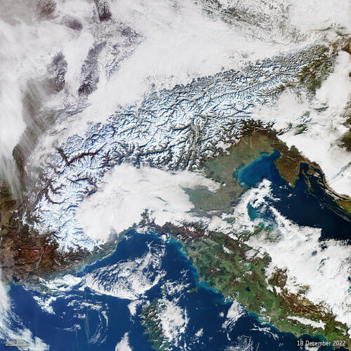 Image:
This Copernicus Sentinel-3 image shows the wide-coverage of snowfall in the Alps, which hopefully bodes well for the coming year.
Image:
This Copernicus Sentinel-3 image shows the wide-coverage of snowfall in the Alps, which hopefully bodes well for the coming year.
výběrové řízení na KP Jihlava
21.12.2022 10:34 ČÚZK - předpisy a opatření Katastrální úřad pro Vysočinu - Katastrální pracoviště Jihlava zveřejnil novou aktualitu: Oznámení o vyhlášení výběrového řízení na služební místo odborný referent v oddělení dokumentace KN Katastrálního pracoviště Jihlava na Katastrálním úřadu pro Vysočinu.výběrové řízení na KP Pelhřimov
21.12.2022 10:31 ČÚZK - předpisy a opatření Katastrální úřad pro Vysočinu - Katastrální pracoviště Pelhřimov zveřejnil novou aktualitu: Oznámení o vyhlášení výběrového řízení na služební místo odborný referent/vrchní referent v oddělení právní vztahy k nemovitostem Katastrálního pracoviště Pelhřimov na Katastrálním úřadu pro Vysočinu.odborný-vrchní referent-právní vztahy k nem - KP Pelhřimov
21.12.2022 9:58 ČÚZK - předpisy a opatření Katastrální úřad pro Vysočinu Katastrální pracoviště Pelhřimovvypisuje výběrové řízení na místo
odborný-vrchní referent-právní vztahy k nem - KP Pelhřimov
odborný-vrchní referent-právní vztahy k nem - KP Pelhřimov
21.12.2022 9:58 ČÚZK - volná místa Katastrální úřad pro Vysočinu Katastrální pracoviště Pelhřimov vypisuje výběrové řízení na místo odborný-vrchní referent-právní vztahy k nem - KP Pelhřimovodborný-vrchní referent-právní vztahy k nem - KP Pelhřimov
21.12.2022 9:58 ČÚZK /Urady/Katastralni-urady/Katastralni-urady/Katastralni-urad-pro-Vysocinu/Uredni-deska/Oznameni-a-jina-uredni-sdeleni/Volna-mista/DMS/odborny-vrchni-referent-pravni-vztahy-k-nem-KP-Pelodborný referent-dokumentace KN-KP Jihlava
21.12.2022 9:54 ČÚZK /Urady/Katastralni-urady/Katastralni-urady/Katastralni-urad-pro-Vysocinu/Uredni-deska/Oznameni-a-jina-uredni-sdeleni/Volna-mista/DMS/odborny-referent-dokumentace-KN-KP-Jihlavaodborný referent-dokumentace KN-KP Jihlava
21.12.2022 9:54 ČÚZK - volná místa Katastrální úřad pro Vysočinu Katastrální pracoviště Jihlava vypisuje výběrové řízení na místo odborný referent-dokumentace KN-KP Jihlavaodborný referent-dokumentace KN-KP Jihlava
21.12.2022 9:54 ČÚZK - předpisy a opatření Katastrální úřad pro Vysočinu Katastrální pracoviště Jihlavavypisuje výběrové řízení na místo
odborný referent-dokumentace KN-KP Jihlava
ESA to invite companies to connect with the Moon
21.12.2022 9:47 ESA Navigation
Space companies in Europe that could create telecommunications and navigation services for missions to the Moon will be invited to bid for the work, following the completion of two feasibility studies.
Upozornění na změnu režimu v úhradách plateb správních poplatků v závěru roku 2022
21.12.2022 9:27 ČÚZK /Urady/Katastralni-urady/Katastralni-urady/Katastralni-urad-pro-Vysocinu/Katastralni-pracoviste/KP-Havlickuv-Brod/O-uradu/Aktuality/Upozorneni-na-zmenu-rezimu-v-uhradach-plateb-spravUpozornění na změnu režimu v úhradách plateb správních poplatků v závěru roku 2022
21.12.2022 9:27 ČÚZK - předpisy a opatření Katastrální úřad pro Vysočinu - Katastrální pracoviště Havlíčkův Brod zveřejnil novou aktualitu:Vážení klienti,
z technických důvodů v období od 29. 12. 2022 do 30. 12. 2022
nepřijímáme platby v hotovosti.
Správní poplatky lze uhradit:
platební kartou
bezhotovostním převodem
kolkovou známkou
Nové verze programů GEUS 27.0 a Geometr 20.0
21.12.2022 9:22 GEUSware Byly vydány nové verze programů GEUS 27.0 a Geometr 20.0. Uživatelé se zaplacenou licenční podporou 2022 pro GEUS/GEOMETR mohou novou verzi okamžitě stáhnout a začít používat. Ostatní uživatelé mají možnost zakoupit upgrade na novou verzi programu.
Program GEUS 27.0 reaguje na novou vyhlášku č. 346/2022 Sb., kterou se mění vyhláška č. 357/2013 Sb., o katastru nemovitostí (katastrální vyhláška), ve znění pozdějších předpisů (účinnost k 1. 1. 2023). Nově obsahuje podporu WFS služeb ČÚZK (zobrazení vektorové katastrální mapy a přehledky ZPMZ), dále byla doplněna podpora varianty GP pro jednoho nabyvatele a možnost rychlé lokalizace polohy parcely KN v lokalitách DKM/KMD.
Do programu Geometr 20.0 byla doplněna podpora GP pro jednoho nabyvatele přenosem z GEUS 27.0 (ze souboru GGP), možnost načítání údajů o parcelách přímo z VFK (ZIP) bez nutnosti mít GeusISKN a podpora zobrazování na monitorech s vysokým rozlišením.
Pokud máte zaplacenou příslušnou licenční podporou 2022, případně upgrade programů a programy nelze spustit, pravděpodobně nemáte GEUS 27.0 či GEOMETR 20.0 povolen na HW klíči.
Jak provést přeprogramování HW klíče a další informace k novým verzím programů najdete po rozkliknutí v článku.
Výběrové řízení na pozici odborný / vrchní referent v oddělení aktualizace katastru nemovitostí Kata
21.12.2022 7:25 ČÚZK - předpisy a opatření Katastrální úřad pro Královéhradecký kraj Katastrální pracoviště Hradec Královévypisuje výběrové řízení na místo
Výběrové řízení na pozici odborný / vrchní referent v oddělení aktualizace katastru nemovitostí Katastrálního pracoviště Hradec Králové
Výběrové řízení na pozici odborný / vrchní referent v oddělení aktualizace katastru nemovitostí Kata
21.12.2022 7:25 ČÚZK /Urady/Katastralni-urady/Katastralni-urady/Katastralni-urad-pro-Kralovehradecky-kraj/Uredni-deska/Oznameni-a-jina-uredni-sdeleni/Volna-mista/DMS/Vyberove-rizeni-na-pozici-odborny-vrchni-referent-Výběrové řízení na pozici odborný / vrchní referent v oddělení aktualizace katastru nemovitostí Kata
21.12.2022 7:25 ČÚZK - volná místa Katastrální úřad pro Královéhradecký kraj Katastrální pracoviště Hradec Králové vypisuje výběrové řízení na místo Výběrové řízení na pozici odborný / vrchní referent v oddělení aktualizace katastru nemovitostí KataAktualizace otevřených dat zastávek veřejné dopravy v Jihočeském kraji
20.12.2022 13:40 Jihočeský krajV sekci Doprava a silniční hospodářství byla aktualizována data zastávek veřejné dopravy v Jihočeském kraji k 20.12.2022. Data jsou k dispozici ke stažení pod licencí CC0 nebo pomocí webových služeb (WMS) či k zobrazení v mapové aplikaci.
Katastrální vyhláška se mění. Pozvánka na online seminář o novele, která začíná platit 1. ledna 2023
20.12.2022 13:37 ZeměměřičČÚZK na svém webu 6. prosince oznámil, že dne 23. 11. byla ve Sbírce zákonů uveřejněna vyhláška č. 346/2022 Sb., kterou se mění vyhláška č. 357/2013 Sb., o katastru nemovitostí (katastrální vyhláška), ve znění pozdějších předpisů. Účinnost vyhlášky nastává dnem 1. 1. 2023. Přednášejícím je Ing. Jan Pěčonka, HD GEO s.r.o., člen Asociace podnikatelů v geomatice (APG). APG měla v rámci pracovní skupiny Katastr nemovitostí […]
The post Katastrální vyhláška se mění. Pozvánka na online seminář o novele, která začíná platit 1. ledna 2023 appeared first on Zeměměřič.
Katastrální vyhláška se mění. Pozvánka na online seminář o novele, která začíná platit 1. ledna 2023
20.12.2022 13:37 ZeměměřičČÚZK na svém webu 6. prosince oznámil, že dne 23. 11. byla ve Sbírce zákonů uveřejněna vyhláška č. 346/2022 Sb., kterou se mění vyhláška č. 357/2013 Sb., o katastru nemovitostí (katastrální vyhláška), ve znění pozdějších předpisů. Účinnost vyhlášky nastává dnem 1. 1. 2023. Ing. Jan Pěčonka z firmy HD GEO pro vás připravil přehled a zve na online seminář. Pokud se vás tedy vyhláška pracovně […]
The post Katastrální vyhláška se mění. Pozvánka na online seminář o novele, která začíná platit 1. ledna 2023 appeared first on Zeměměřič.
Katastrální vyhláška se mění. Záznam semináře a komentovaná vyhláška (aktualizováno)
20.12.2022 13:37 ZeměměřičČÚZK na svém webu 6. prosince oznámil, že dne 23. 11. byla ve Sbírce zákonů uveřejněna vyhláška č. 346/2022 Sb., kterou se mění vyhláška č. 357/2013 Sb., o katastru nemovitostí (katastrální vyhláška), ve znění pozdějších předpisů. Účinnost vyhlášky nastává dnem 1. 1. 2023. Přednášejícím na webináři byl Ing. Jan Pěčonka, HD GEO s.r.o., člen Asociace podnikatelů v geomatice (APG). APG měla v rámci pracovní skupiny […]
The post Katastrální vyhláška se mění. Záznam semináře a komentovaná vyhláška (aktualizováno) appeared first on Zeměměřič.
Katastrální vyhláška se mění. Pozvánka na online seminář o novele, která začíná platit 1. ledna 2023
20.12.2022 13:37 ZeměměřičČÚZK na svém webu 6. prosince oznámil, že dne 23. 11. byla ve Sbírce zákonů uveřejněna vyhláška č. 346/2022 Sb., kterou se mění vyhláška č. 357/2013 Sb., o katastru nemovitostí (katastrální vyhláška), ve znění pozdějších předpisů. Účinnost vyhlášky nastává dnem 1. 1. 2023. Ing. Jan Pěčonka z firmy HD GEO, který byl členem připomínkovací skupiny, pro vás připravil přehled změn a novinek a zve na online […]
The post Katastrální vyhláška se mění. Pozvánka na online seminář o novele, která začíná platit 1. ledna 2023 appeared first on Zeměměřič.
20221220_Rada / odborný rada oddělení právních vztahů k nemovitostem
20.12.2022 13:24 ČÚZK /Urady/Katastralni-urady/Katastralni-urady/Katastralni-urad-pro-Stredocesky-kraj/Katastralni-pracoviste/KP-Kladno/O-uradu/Aktuality/20210922_Odborny-referent-oddeleni-aktualizace-(1)20221220_Rada / odborný rada oddělení právních vztahů k nemovitostem
20.12.2022 13:24 ČÚZK - předpisy a opatření Katastrální úřad pro Středočeský kraj - Katastrální pracoviště Kladno Vyhlášení výběrového řízení: Rada / odborný rada oddělení právních vztahů k nemovitostem V části "Úřední deska", v sekci "Oznámení a jiná úřední sdělení" bylo vystaveno "Oznámení o vyhlášení výběrového řízení na obsazení služebního místa Rada / odborný rada oddělení právních vztahů k nemovitostem"Rada / odborný rada oddělení právních vztahů k nemovitostem
20.12.2022 13:23 ČÚZK - předpisy a opatření Katastrální úřad pro Středočeský kraj - Katastrální pracoviště Kladnovypisuje výběrové řízení na místo: Rada / odborný rada oddělení právních vztahů k nemovitostem
Rada / odborný rada oddělení právních vztahů k nemovitostem
Rada / odborný rada oddělení právních vztahů k nemovitostem
20.12.2022 13:23 ČÚZK - volná místa Katastrální úřad pro Středočeský kraj vypisuje výběrové řízení na místo Rada / odborný rada oddělení právních vztahů k nemovitostemRada / odborný rada oddělení právních vztahů k nemovitostem
20.12.2022 13:23 ČÚZK - volná místa Katastrální úřad pro Středočeský kraj Katastrální pracoviště Kladno vypisuje výběrové řízení na místo Rada / odborný rada oddělení právních vztahů k nemovitostemRada / odborný rada oddělení právních vztahů k nemovitostem
20.12.2022 13:23 ČÚZK - předpisy a opatření Katastrální úřad pro Středočeský kraj Katastrální pracoviště Kladnovypisuje výběrové řízení na místo
Rada / odborný rada oddělení právních vztahů k nemovitostem
Rada / odborný rada oddělení právních vztahů k nemovitostem
20.12.2022 13:23 ČÚZK - předpisy a opatření Katastrální úřad pro Středočeský kraj Katastrální pracoviště Kladnovypisuje výběrové řízení na místo: Rada / odborný rada oddělení právních vztahů k nemovitostem
Rada / odborný rada oddělení právních vztahů k nemovitostem
EASA zveřejnila finální AMC/GM pro zavádění U-space v EU
20.12.2022 11:13 UAVAEASA dnes zveřejnila finální AMC/GM (soubor přijatelných způsobů průkazu a poradenský materiál) na podporu harmonizovaného, bezpečného a efektivního zavádění U-space v celé Evropské unii. Na tuto verzi se čekalo poměrně dlouho, jelikož by měla vypořádat v rámci možností stovky obdržených komentářů z letošních veřejných konzultací. Zde ke stažení:
The post EASA zveřejnila finální AMC/GM pro zavádění U-space v EU appeared first on UAV Aliance pro bezpilotní letecký průmysl.
Oznámení Katastrálního pracoviště Benešov
20.12.2022 10:53 ČÚZK /Urady/Katastralni-urady/Katastralni-urady/Katastralni-urad-pro-Stredocesky-kraj/Katastralni-pracoviste/KP-Benesov/O-uradu/Aktuality/Oznameni-Katastralniho-pracoviste-BenesovOznámení Katastrálního pracoviště Benešov
20.12.2022 10:53 ČÚZK - předpisy a opatření Katastrální úřad pro Středočeský kraj - Katastrální pracoviště Benešov zveřejnil novou aktualitu: Z technických důvodů nebude možné na katastrálním pracovišti Benešov ve čtvrtek 29. 12. 2022 platit v hotovosti.Platbu za poskytnuté služby či podání však bude možné uskutečnit kolkovou známkou či platební kartou. Úhradu bude možné též provést na základě vystavení podkladu pro platbu. Stejně tak zůstává zachována možnost uvést do návrhu na vklad požadavek, aby byly některému z účastníků zaslány podklady pro platbu na zvolenou e-mailovou adresu.
Za případné komplikace se omlouváme.
Výběrové řízení
20.12.2022 10:21 ČÚZK - předpisy a opatření Katastrální úřad pro Plzeňský kraj - Katastrální pracoviště Rokycany zveřejnil novou aktualitu: Ředitelka Katastrálního úřadu pro Plzeňský kraj jako služební orgán příslušný podle § 10 odst. 1 písm. f) zákona č. 234/2014 Sb., o státní službě ve znění pozdějších předpisů, vyhlašuje výběrové řízení na služební místo odborný/vrchní referent – vedení katastrální mapy VKM1301, oddělení aktualizace a dokumentace KN, Katastrální úřad pro Plzeňský kraj, Katastrální pracoviště Rokycany, v oboru služby 55. Zeměměřictví a katastr nemovitostí.Výběrové řízení na služební místo odborný/vrchní referent – vedení katastrální mapy VKM1301 KP Rokyc
20.12.2022 10:18 ČÚZK - předpisy a opatření Katastrální úřad pro Plzeňský kraj Katastrální pracoviště Rokycanyvypisuje výběrové řízení na místo
Výběrové řízení na služební místo odborný/vrchní referent – vedení katastrální mapy VKM1301 KP Rokycany
Výběrové řízení na služební místo odborný/vrchní referent – vedení katastrální mapy VKM1301 KP Rokyc
20.12.2022 10:18 ČÚZK /Urady/Katastralni-urady/Katastralni-urady/Katastralni-urad-pro-Plzensky-kraj/Uredni-deska/Oznameni-a-jina-uredni-sdeleni/Volna-mista/DMS/Vyberove-rizeni-na-sluzebni-misto-odborny-vrchni-rVýběrové řízení na služební místo odborný/vrchní referent – vedení katastrální mapy VKM1301 KP Rokyc
20.12.2022 10:18 ČÚZK - volná místa Katastrální úřad pro Plzeňský kraj Katastrální pracoviště Rokycany vypisuje výběrové řízení na místo Výběrové řízení na služební místo odborný/vrchní referent – vedení katastrální mapy VKM1301 KP RokycRok 2022: podívejte se na to nejlepší z naší práce
20.12.2022 1:00 VARS.czPodívejte se, na co všechno jsme u nás ve VARS hrdí za loňský rok. Nejúspěšnější projekty, nové výzvy, ocenění a hlavně spousta práce, která nám dělala radost a vám pomůže k lepšímu cestování.
Dispečink nové generace pro České Budějovice jde do testovacího provozu
20.12.2022 1:00 VARS.czJihočeská
metropole má dlouhodobě pověst jednoho z „nejucpanějších“ měst v Česku. Na
paty šlape i dvanáctinásobně větší Praze. V březnu město dostane nástroj,
jak to může změnit. V Českých Budějovicích začne od Nového roku v testovacím provozu fungovat nový moderní
dispečink, který se stane „dopravním mozkem“ města. Dodává jej VARS BRNO.