


![]()

zprávy
zdroje zpráv:TIBCO WebFOCUS Humanizes the User Experience and Dynamically Scales for Efficiency and Business Continuity
19.4.2022 18:40 GISCafe.com Webcasts-Webinars Innovation Culminates in a Containerized, Cloud-Native Solution, Simplifying Access and Improving Data ManagementPALO ALTO, Calif. — (BUSINESS …
Satellogic to Participate in the GEOINT 2022 Symposium
19.4.2022 18:40 GISCafe.com Webcasts-Webinars NEW YORK, April 19, 2022 (GLOBE NEWSWIRE) -- Satellogic Inc. (NASDAQ: SATL), a leader in sub-meter resolution satellite imagery collection, today …AeroVironment Donates Over 100 Quantix Recon Unmanned Aircraft Systems to the Ministry of Defence of Ukraine and Territorial Forces
19.4.2022 18:40 GISCafe.com Webcasts-Webinars Donation is independent of other AeroVironment systems already being provided to Ukraine by the United States GovernmentDonated Quantix Recon …
OpenDataScience Europe workshop 2022
19.4.2022 14:07 Společnost pro fotogrammetrii a dálkový průzkum Dear Sir or MadamThe ‘Geo-harmonizer’ project team and the Department of Geomatics are pleased to invite you to the OpenDataScience Europe workshop 2022, which will take place at the Faculty of Civil Engineering of the Czech Technical University in Prague, from the 13th to the 16th of June. This hybrid event is organised as part of the project ‘Geo-harmonizer: EU-wide automated mapping system for harmonization of Open Data based on FOSS4G and Machine Learning’, financed by the European Commission through the European Health and Digital Executive Agency (HaDEA). The workshop aims to provide training to young researchers and professionals, as well to bring together international experts and emerging scientists around the following topics: Dynamic mapping of land cover, vegetation, climate and environmental quality indices, Spatiotemporal Machine Learning using Ensemble techniques, Earth Data Cubes: spatiotemporal overlay, modelling and visualisation, Geocomputing and geo-harmonization using Python, R and Open Source GIS GDAL, GRASS GIS, QGIS Processing large raster datasets using High Performance and Distributed Computing, Using geospatial harmonized European map products. Using AR/VR for geospatial data visualisation. We are also pleased to host international guest speakers such as Prof. John Wenzhong Shi from the Hong Kong Polytechnic University, Doc. Ing. Tomáš Pajdla, From CIIRC ČVUT, Prof. Arzu Çöltekin (University of Applied Sciences & Arts Northwestern Switzerland, Institute of Interactive Technologies), Dr Helena Mitasova from the North Carolina State University (US), Dr Pierre Soille from the Joint Research Centre, and Jiří Pilař, DG CONNECT programme.Schedule: 13-14 June: The first two days are dedicated to […]OpenDataScience Europe workshop 2022
19.4.2022 14:07 Společnost pro fotogrammetrii a dálkový průzkumDear Sir or MadamThe ‘Geo-harmonizer’ project team and the Department of Geomatics are pleased to invite you to the OpenDataScience Europe workshop 2022, which will take place at the Faculty of Civil Engineering of the Czech Technical University in Prague, from the 13th to the 16th of June. This hybrid event is organised as part of the project ‘Geo-harmonizer: EU-wide automated mapping system for harmonization of Open Data based on FOSS4G and Machine Learning’, financed by the European Commission through the European Health and Digital Executive Agency (HaDEA). The workshop aims to provide training to young researchers and professionals, as well to bring together international experts and emerging scientists around the following topics: Dynamic mapping of land cover, vegetation, climate and environmental quality indices, Spatiotemporal Machine Learning using Ensemble techniques, Earth Data Cubes: spatiotemporal overlay, modelling and visualisation, Geocomputing and geo-harmonization using Python, R and Open Source GIS GDAL, GRASS GIS, QGIS Processing large raster datasets using High Performance and Distributed Computing, Using geospatial harmonized European map products. Using AR/VR for geospatial data visualisation. We are also pleased to host international guest speakers such as Prof. John Wenzhong Shi from the Hong Kong Polytechnic University, Doc. Ing. Tomáš Pajdla, From CIIRC ČVUT, Prof. Arzu Çöltekin (University of Applied Sciences & Arts Northwestern Switzerland, Institute of Interactive Technologies), Dr Helena Mitasova from the North Carolina State University (US), Dr Pierre Soille from the Joint Research Centre, and Jiří Pilař, DG CONNECT programme.Schedule: 13-14 June: The first two days are dedicated to […]
The post OpenDataScience Europe workshop 2022 appeared first on SFDP.
OpenDataScience Europe workshop 2022
19.4.2022 14:07 Společnost pro fotogrammetrii a dálkový průzkumDear Sir or MadamThe ‘Geo-harmonizer’ project team and the Department of Geomatics are pleased to invite you to the OpenDataScience Europe workshop 2022, which will take place at the Faculty of Civil Engineering of the Czech Technical University in Prague, from the 13th to the 16th of June. This hybrid event is organised as part of the project ‘Geo-harmonizer: EU-wide automated mapping system for harmonization of Open Data based on FOSS4G and Machine Learning’, financed by the European Commission through the European Health and Digital Executive Agency (HaDEA). The workshop aims to provide training to young researchers and professionals, as well to bring together international experts and emerging scientists around the following topics: Dynamic mapping of land cover, vegetation, climate and environmental quality indices, Spatiotemporal Machine Learning using Ensemble techniques, Earth Data Cubes: spatiotemporal overlay, modelling and visualisation, Geocomputing and geo-harmonization using Python, R and Open Source GIS GDAL, GRASS GIS, QGIS Processing large raster datasets using High Performance and Distributed Computing, Using geospatial harmonized European map products. Using AR/VR for geospatial data visualisation. We are also pleased to host international guest speakers such as Prof. John Wenzhong Shi from the Hong Kong Polytechnic University, Doc. Ing. Tomáš Pajdla, From CIIRC ČVUT, Prof. Arzu Çöltekin (University of Applied Sciences & Arts Northwestern Switzerland, Institute of Interactive Technologies), Dr Helena Mitasova from the North Carolina State University (US), Dr Pierre Soille from the Joint Research Centre, and Jiří Pilař, DG CONNECT programme.Schedule: 13-14 June: The first two days are dedicated to […]
The post OpenDataScience Europe workshop 2022 appeared first on SFDP.
XXIV ISPRS Congress 2022 – Newsletter April
19.4.2022 14:05 Společnost pro fotogrammetrii a dálkový průzkumGet ready for Nice!Nice is NiceOur Keynote Speakers Our Programme Scientific Track + 69 scientific sessions + 400 oral presentations+ 800 poster presentations Programme available soon Technology TrackIndustry presenting their latest technology innovations Forum Track Discussing together the hot topics for our communities Tutorials Don’t miss the chance to learn about new knowledge and technology Registrations will close on 15 April 2022 ! Register now Summer School Intensive learning on point cloud generation and processing.Only a few places left ! Register now Social Programme Network and have fun with new colleagues and friends Exhibition & Sponsorship Join our partners now ! Exhibition : Only a few booths left ! Technology Track : 2 time slots left To contact us : sponsorship@isprs2020-nice.com AccommodationBook your room now!Copyright © ISPRS2020 All rights reserved.
The post XXIV ISPRS Congress 2022 – Newsletter April appeared first on SFDP.
XXIV ISPRS Congress 2022 – Newsletter April
19.4.2022 14:05 Společnost pro fotogrammetrii a dálkový průzkum Get ready for Nice!Nice is NiceOur Keynote Speakers Our Programme Scientific Track + 69 scientific sessions + 400 oral presentations+ 800 poster presentations Programme available soon Technology TrackIndustry presenting their latest technology innovations Forum Track Discussing together the hot topics for our communities Tutorials Don’t miss the chance to learn about new knowledge and technology Registrations will close on 15 April 2022 ! Register now Summer School Intensive learning on point cloud generation and processing.Only a few places left ! Register now Social Programme Network and have fun with new colleagues and friends Exhibition & Sponsorship Join our partners now ! Exhibition : Only a few booths left ! Technology Track : 2 time slots left To contact us : sponsorship@isprs2020-nice.com AccommodationBook your room now!Copyright © ISPRS2020 All rights reserved.Odborný referent – podatelna v personálním oddělení Katastrálního úřadu pro Zlínský kraj
19.4.2022 13:48 ČÚZK - předpisy a opatření Katastrální úřad pro Zlínský kraj kancelář ředitelevypisuje výběrové řízení na místo
Odborný referent – podatelna v personálním oddělení Katastrálního úřadu pro Zlínský kraj
Odborný referent – podatelna v personálním oddělení Katastrálního úřadu pro Zlínský kraj
19.4.2022 13:48 ČÚZK /Urady/Katastralni-urady/Katastralni-urady/Katastralni-urad-pro-Zlinsky-kraj/Uredni-deska/Oznameni-a-jina-uredni-sdeleni/Volna-mista/DMS/Odborny-referent-–-podatelna-v-personalnim-oddelenOdborný referent – podatelna v personálním oddělení Katastrálního úřadu pro Zlínský kraj
19.4.2022 13:48 ČÚZK - volná místa Katastrální úřad pro Zlínský kraj kancelář ředitele vypisuje výběrové řízení na místo Odborný referent – podatelna v personálním oddělení Katastrálního úřadu pro Zlínský krajPodpora SOAP u WFS služeb
19.4.2022 13:00 ČÚZK - Geoportál Podpora SOAP u WFS služebU INSPIRE harmonizovaných WFS služeb pro témata AD, AU, BU, CP a CPX jsou nově podporovány dotazy ve formě SOAP ve verzi 1.1. Implementace vychází ze standardu OGC WFS 2.0. Přístupové url adresy pro SOAP jsou odlišné od url adres pro dotazy ve formě KVP a jsou uvedeny v capabilities služeb.
Podpora SOAP u WFS služeb
19.4.2022 13:00 ČÚZK - Geoportál Podpora SOAP u WFS služebU INSPIRE harmonizovaných WFS služeb pro témata AD, AU, BU, CP a CPX jsou nově podporovány dotazy ve formě SOAP ve verzi 1.1. Implementace vychází ze standardu OGC WFS 2.0. Přístupové url adresy pro SOAP jsou odlišné od url adres pro dotazy ve formě KVP a jsou uvedeny v capabilities služeb.
Výběrové řízení
19.4.2022 11:23 ČÚZK /Urady/Katastralni-urady/Katastralni-urady/Katastralni-urad-pro-Liberecky-kraj/Katastralni-pracoviste/KP-Jablonec-nad-Nisou/O-uradu/Aktuality/Vyberove-rizeni-(2)Výběrové řízení
19.4.2022 11:23 ČÚZK - předpisy a opatření Katastrální úřad pro Liberecký kraj - Katastrální pracoviště Jablonec nad Nisou zveřejnil novou aktualitu: Oznámení o vyhlášení výběrového řízení na služební místo rada / odborný rada v oddělení aktualizace a dokumentace KN na KP Jablonec nad Nisoumísto rada / odborný rada v oddělení aktualizace a dokumentace KN
19.4.2022 11:18 ČÚZK - předpisy a opatření Katastrální úřad pro Liberecký kraj - Katastrální pracoviště Jablonec nad Nisouvypisuje výběrové řízení na místo
místo rada / odborný rada v oddělení aktualizace a dokumentace KN
místo rada / odborný rada v oddělení aktualizace a dokumentace KN
19.4.2022 11:18 ČÚZK - volná místa Katastrální úřad pro Liberecký kraj - Katastrální pracoviště Jablonec nad Nisou vypisuje výběrové řízení na místo místo rada / odborný rada v oddělení aktualizace a dokumentace KNrada / odborný rada v oddělení aktualizace a dokumentace KN
19.4.2022 11:18 ČÚZK /Urady/Katastralni-urady/Katastralni-urady/Katastralni-urad-pro-Liberecky-kraj/Uredni-deska/Oznameni-a-jina-uredni-sdeleni/Volna-mista/misto-rada-odborny-rada-v-oddeleni-aktualizace-arada / odborný rada v oddělení aktualizace a dokumentace KN
19.4.2022 11:18 ČÚZK - předpisy a opatření Katastrální úřad pro Liberecký kraj - Katastrální pracoviště Jablonec nad Nisouvypisuje výběrové řízení na místo
rada / odborný rada v oddělení aktualizace a dokumentace KN
místo rada / odborný rada v oddělení aktualizace a dokumentace KN
19.4.2022 11:18 ČÚZK /Urady/Katastralni-urady/Katastralni-urady/Katastralni-urad-pro-Liberecky-kraj/Uredni-deska/Oznameni-a-jina-uredni-sdeleni/Volna-mista/misto-rada-odborny-rada-v-oddeleni-aktualizace-arada / odborný rada v oddělení aktualizace a dokumentace KN
19.4.2022 11:18 ČÚZK - volná místa Katastrální úřad pro Liberecký kraj - Katastrální pracoviště Jablonec nad Nisou vypisuje výběrové řízení na místo rada / odborný rada v oddělení aktualizace a dokumentace KNVR do 26.06
19.4.2022 10:43 ČÚZK /Urady/Katastralni-urady/Katastralni-urady/Katastralni-urad-pro-hlavni-mesto-Prahu/O-uradu/Aktuality/VR-do-04-05VR do 04.05
19.4.2022 10:43 ČÚZK /Urady/Katastralni-urady/Katastralni-urady/Katastralni-urad-pro-hlavni-mesto-Prahu/O-uradu/Aktuality/VR-do-04-05VR do 04.05
19.4.2022 10:43 ČÚZK - předpisy a opatření Katastrální úřad pro hlavní město Prahu - Katastrální pracoviště Praha zveřejnil novou aktualitu: Ředitelka úřadu vyhlašuje výběrové řízení na služební místo:* odborný referent/vrchní referent – návrh zápisu v katastru
* rada/odborný rada – právník
VR do 23.05
19.4.2022 10:43 ČÚZK - předpisy a opatření Katastrální úřad pro hlavní město Prahu - Katastrální pracoviště Praha zveřejnil novou aktualitu: Ředitelka úřadu vyhlašuje výběrové řízení na služební místo:* rada/odborný rada – vedoucí oddělení obnovy a revize KN I.
VR do 02.8
19.4.2022 10:43 ČÚZK - předpisy a opatření Katastrální úřad pro hlavní město Prahu - Katastrální pracoviště Praha zveřejnil novou aktualitu: Ředitelka úřadu vyhlašuje výběrové řízení na služební místo:* rada/odborný rada – revize katastrálního operátu
VR do 26.06
19.4.2022 10:43 ČÚZK - předpisy a opatření Katastrální úřad pro hlavní město Prahu - Katastrální pracoviště Praha zveřejnil novou aktualitu: Ředitelka úřadu vyhlašuje výběrové řízení na služební místo:* rada/odborný rada – kontrolor
VR do 02.8
19.4.2022 10:43 ČÚZK - předpisy a opatření Katastrální úřad pro hlavní město Prahu - Katastrální pracoviště Praha zveřejnil novou aktualitu: Ředitelka úřadu vyhlašuje výběrové řízení na služební místo:rada/odborný rada – revize katastrálního operátu
VR do 04.05
19.4.2022 10:43 ČÚZK - předpisy a opatření Katastrální úřad pro hlavní město Prahu - Katastrální pracoviště Praha zveřejnil novou aktualitu: Ředitelka úřadu vyhlašuje výběrové řízení na služební místo:* odborný referent/vrchní referent – návrh zápisu v katastru
* rada/odborný rada – právník
* odborný referent/vrchní referent – zápis do protokolu řízení V a Z
VR do 23.05
19.4.2022 10:43 ČÚZK /Urady/Katastralni-urady/Katastralni-urady/Katastralni-urad-pro-hlavni-mesto-Prahu/O-uradu/Aktuality/VR-do-04-05VR do 02.8
19.4.2022 10:43 ČÚZK /Urady/Katastralni-urady/Katastralni-urady/Katastralni-urad-pro-hlavni-mesto-Prahu/O-uradu/Aktuality/VR-do-04-05rada/odborný rada – právník
19.4.2022 10:38 ČÚZK - volná místa Katastrální úřad pro hlavní město Prahu Katastrální pracoviště Praha vypisuje výběrové řízení na místo rada/odborný rada – právníkrada/odborný rada – právník
19.4.2022 10:38 ČÚZK /Urady/Katastralni-urady/Katastralni-urady/Katastralni-urad-pro-hlavni-mesto-Prahu/Uredni-deska/Oznameni-a-jina-uredni-sdeleni/Volna-mista/DMS/rada-odborny-rada-–-pravnik-(2)rada/odborný rada – právník
19.4.2022 10:38 ČÚZK - předpisy a opatření Katastrální úřad pro hlavní město Prahu Katastrální pracoviště Prahavypisuje výběrové řízení na místo
rada/odborný rada – právník
20220419 – Dokončení instalace nové verze ISKN 9.3
19.4.2022 10:16 ČÚZK - Výměnný formát ISKN Instalace ISKN 9.3 byla dokončena 18.04.2022. Od tohoto data jsou exporty VF ISKN vydávány ve verzi 6.0. Exporty a importy VFK jsou nyní umožněny pouze v kódování UTF-8. Dosud používaná kódování již nejsou nadále podporována. Po přechodnou dobu lze využít aplikaci "Konverze VFK", která umožňuje obousměrnou konverzi souborů VFK mezi kódováním ISO8859-2 a UTF-8.20220419 – Dokončení instalace nové verze ISKN 9.3
19.4.2022 10:16 ČÚZK - předpisy a opatření Instalace ISKN 9.3 byla dokončena 18.04.2022. Od tohoto data jsou exporty VF ISKN vydávány ve verzi 6.0. Exporty a importy VFK jsou nyní umožněny pouze v kódování UTF-8. Dosud používaná kódování již nejsou nadále podporována. Po přechodnou dobu lze využít aplikaci "Konverze VFK", která umožňuje obousměrnou konverzi souborů VFK mezi kódováním ISO8859-2 a UTF-8.20220419 – Dokončení instalace nové verze ISKN 9.3
19.4.2022 10:16 ČÚZK - Výměnný formát ISKN Instalace ISKN 9.3 byla dokončena 18.04.2022. Od tohoto data jsou exporty VF ISKN vydávány ve verzi 6.0. Exporty a importy VFK jsou nyní umožněny pouze v kódování UTF-8. Dosud používaná kódování již nejsou nadále podporována. Po přechodnou dobu lze využít aplikaci "Konverze VFK", která umožňuje obousměrnou konverzi souborů VFK mezi kódováním ISO8859-2 a UTF-8.20220419_odborný referent/vrchní referent v oddělení aktualizace popisných informací I. KN
19.4.2022 10:03 ČÚZK - předpisy a opatření Katastrální úřad pro Středočeský kraj - Katastrální pracoviště Praha-západ Vyhlášení výběrového řízení: odborný referent/vrchní referent v oddělení aktualizace popisných informací I. KN odboru právních vztahů k nemovitostem V části "Úřední deska", v sekci "Oznámení a jiná úřední sdělení" bylo vystaveno "Oznámení o vyhlášení výběrového řízení na obsazení služebního místa odborný referent/vrchní referent v oddělení aktualizace popisných informací I. KN odboru právních vztahů k nemovitostem"20220419_odborný referent/vrchní referent v oddělení aktualizace popisných informací I. KN
19.4.2022 10:03 ČÚZK /Urady/Katastralni-urady/Katastralni-urady/Katastralni-urad-pro-Stredocesky-kraj/Katastralni-pracoviste/KP-Praha-zapad/O-uradu/Aktuality/20210922_Odborny-referent-oddeleni-aktualizace-(2)odborný referent/vrchní referent v oddělení aktualizace popisných informací I. KN odboru právních vz
19.4.2022 10:02 ČÚZK - volná místa Katastrální úřad pro Středočeský kraj - Katastrální pracoviště Praha-západ vypisuje výběrové řízení na místo odborný referent/vrchní referent v oddělení aktualizace popisných informací I. KN odboru právních vzodborný referent/vrchní referent v oddělení aktualizace popisných informací I. KN odboru právních vz
19.4.2022 10:02 ČÚZK - předpisy a opatření Katastrální úřad pro Středočeský kraj - Katastrální pracoviště Praha-západvypisuje výběrové řízení na místo odborný referent/vrchní referent v oddělení aktualizace popisných informací I. KN odboru právních vztahů k nemovitostem
odborný referent/vrchní referent v oddělení aktualizace popisných informací I. KN odboru právních vztahů k nemovitostem
odborný referent/vrchní referent v oddělení aktualizace popisných informací I. KN odboru právních vz
19.4.2022 10:02 ČÚZK /Urady/Katastralni-urady/Katastralni-urady/Katastralni-urad-pro-Stredocesky-kraj/Uredni-deska/Oznameni-a-jina-uredni-sdeleni/Volna-mista/odborny-referent-vrchni-referent-v-oddeleni-aktual20220419_rada/ odborný rada v právním oddělení odboru právních vztahů k nemovitostem
19.4.2022 9:55 ČÚZK /Urady/Katastralni-urady/Katastralni-urady/Katastralni-urad-pro-Stredocesky-kraj/Katastralni-pracoviste/KP-Praha-zapad/O-uradu/Aktuality/20210922_Odborny-referent-oddeleni-aktualizace-(1)20220419_rada/ odborný rada v právním oddělení odboru právních vztahů k nemovitostem
19.4.2022 9:55 ČÚZK - předpisy a opatření Katastrální úřad pro Středočeský kraj - Katastrální pracoviště Praha-západ Vyhlášení výběrového řízení: rada/ odborný rada v právním oddělení odboru právních vztahů k nemovitostem V části "Úřední deska", v sekci "Oznámení a jiná úřední sdělení" bylo vystaveno "Oznámení o vyhlášení výběrového řízení na obsazení služebního místa rada/ odborný rada v právním oddělení odboru právních vztahů k nemovitostem "rada/ odborný rada v právním oddělení odboru právních vztahů k nemovitostem
19.4.2022 9:54 ČÚZK - volná místa Katastrální úřad pro Středočeský kraj - Katastrální pracoviště Praha-západ vypisuje výběrové řízení na místo rada/ odborný rada v právním oddělení odboru právních vztahů k nemovitostemrada/ odborný rada v právním oddělení odboru právních vztahů k nemovitostem
19.4.2022 9:54 ČÚZK - předpisy a opatření Katastrální úřad pro Středočeský kraj - Katastrální pracoviště Praha-západvypisuje výběrové řízení na místo rada/ odborný rada v právním oddělení odboru právních vztahů k nemovitostem
rada/ odborný rada v právním oddělení odboru právních vztahů k nemovitostem
rada/ odborný rada v právním oddělení odboru právních vztahů k nemovitostem
19.4.2022 9:54 ČÚZK /Urady/Katastralni-urady/Katastralni-urady/Katastralni-urad-pro-Stredocesky-kraj/Uredni-deska/Oznameni-a-jina-uredni-sdeleni/Volna-mista/rada-odborny-rada-v-pravnim-oddeleni-odboru-pravaplikace Konverze VFK
19.4.2022 9:33 ČÚZK - RSS kanál pro zeměměřiče V souvislosti s přechodem databáze ISKN na kódování UTF-8 došlo k úpravě exportu a importu VFK. Nově je umožněno pouze kódování UTF-8. Dosud používaná kódování již nebudou nadále podporována. Po přechodnou dobu je zatímto účelem na stránce https://konverzevfk.cuzk.cz zveřejněna aplikace "Konverze VFK", která slouží pro případnou konverzi souborů VFK ze starého kódování ISO8859-2 do nového kódování UTF-8.aplikace Konverze VFK
19.4.2022 9:33 ČÚZK - předpisy a opatření Český úřad zeměměřický a katastrální zveřejnil novou aktualitu: V souvislosti s přechodem databáze ISKN na kódování UTF-8 došlo k úpravě exportu a importu VFK. Nově je umožněno pouze kódování UTF-8. Dosud používaná kódování již nebudou nadále podporována. Po přechodnou dobu je zatímto účelem na stránce https://konverzevfk.cuzk.cz zveřejněna aplikace "Konverze VFK", která slouží pro případnou konverzi souborů VFK ze starého kódování ISO8859-2 do nového kódování UTF-8.aplikace Konverze VFK
19.4.2022 9:33 ČÚZK /Zememerictvi/Zememericke-cinnosti/Aktuality-pro-zememerice/2020/aplikace-Konverze-VFKDigitální technická mapa České republiky
19.4.2022 9:25 Hrdlička Mapa přináší nové zákonné povinnosti. Víte, jak na ně?Digitální technická mapa ČR
19.4.2022 9:22 Hrdlička Mapa přináší nové zákonné povinnosti. Víte, jak na ně?webinář Hub4Everybody (pozvánka)
19.4.2022 8:15 GISportal.cz
Hromadí se vám v počítači digitální mapy? Například výsledky studentských prací, pocitové mapy lokalit, výsledky terénních průzkumů nebo vědeckých experimentů? Chcete výsledky Vašich aktivit zveřejnit, propagovat nebo je diskutovat napříč různými cílovými skupinami? Odpovědí na Vaše požadavky je systém pro publikování a sdílení geografických dat. Nabízíme unikátní, škálovatelné a otevřené řešení, které je vhodné pro […]
The post webinář Hub4Everybody (pozvánka) appeared first on GISportal.cz.
webinář Hub4Everybody (pozvánka)
19.4.2022 8:15 GISportal.czHromadí se vám v počítači digitální mapy? Například výsledky studentských prací, pocitové mapy lokalit, výsledky terénních průzkumů nebo vědeckých experimentů? Chcete výsledky Vašich aktivit zveřejnit, propagovat nebo je diskutovat napříč různými cílovými skupinami? Odpovědí na Vaše požadavky je systém pro publikování a sdílení geografických dat. Nabízíme unikátní, škálovatelné a otevřené řešení, které je vhodné pro […]
The post webinář Hub4Everybody (pozvánka) appeared first on GISportal.cz.
Planet Partners with Canadian Universities to Research Biodiversity, Regeneration, and Human Impact in Boreal Forests
19.4.2022 1:54 GISCafe.com Webcasts-Webinars SAN FRANCISCO — (BUSINESS WIRE) — April 18, 2022 —Planet Labs PBC (NYSE: PL), a leading provider of daily data and insights about …
BlackSky Sets New Standard for Agile Satellite Operations to Support Customers During Ukraine Crisis
19.4.2022 1:54 GISCafe.com Webcasts-Webinars In response to the conflict, company shifted orbits, launched two new satellites within 45 daysHERNDON, Va. — (BUSINESS WIRE) — April …
Ursa Space Systems Announces Availability of Global Oil Storage and Auto Manufacturing Index on Google Cloud Analytics Hub
19.4.2022 1:54 GISCafe.com Webcasts-Webinars ITHACA, N.Y., April 18, 2022 — (PRNewswire) — Ursa Space Systems, a global satellite intelligence infrastructure provider, today …Hub4Everybody pro ty, co chtějí publikovat digitální mapy na open source technologiích
18.4.2022 22:06 GeoBusinessHromadí se vám v počítači digitální mapy, například výsledky studentských prací, pocitové mapy míst, výsledky terénních průzkumů nebo vědeckých experimentů? Chcete publikovat, propagovat nebo diskutovat o výsledcích své činnosti ve skupině? Hub4Everybody je určen pro ty, co potřebují pracovat s geografickými daty, ale přitom nechtějí nebo nemohou data publikovat v komerčních profesionálních geografických informačních systémech […]
The post Hub4Everybody pro ty, co chtějí publikovat digitální mapy na open source technologiích appeared first on GeoBusiness.
Drone Nerds Displays Emerging Drone Technology Solutions at AUVSI XPONENTIAL
18.4.2022 21:33 GISCafe.com Webcasts-Webinars Dania Beach, FL, April 18, 2022 (GLOBE NEWSWIRE) -- South Florida- based Drone Nerds, a leader in consumer and enterprise drone solutions, will be …Planet Partners with SynMax to Provide Energy Intelligence and Monitor Dark Vessels
18.4.2022 16:40 GISCafe.com Webcasts-Webinars SAN FRANCISCO — (BUSINESS WIRE) — April 18, 2022 —Planet Labs PBC (NYSE: PL), a leading provider of daily data and insights about …
Media Advisory: infiniDome Is Exhibiting at AUVSI Xponential
18.4.2022 16:40 GISCafe.com Webcasts-Webinars (BUSINESS WIRE) — April 18, 2022 —infiniDome:
WHO:
infiniDome, a GPS security company bringing end-to-end jamming monitoring and …
TruWeather Solutions Forges Partnership with Iris Automation for UAS Weather-enhanced Ground-based Surveillance
18.4.2022 16:40 GISCafe.com Webcasts-Webinars RESTON, Va. and RENO, Nev., April 18, 2022 — (PRNewswire) — Micro weather data and analytics firm TruWeather Solutions has joined forces …Jarní workshopy s ARCDATA PRAHA – Hostované vrstvy prvků (PR)
18.4.2022 8:57 GISportal.cz
Společnost ARCDATA PRAHA připravila jarní sérii webových seminářů, zaměřenou na nejrůznější aplikace systému ArcGIS. Vedle tipů pro práci v desktopové aplikaci se seznámíte s postupy pro publikaci vektorových dat online, způsobem, jak je vizualizovat a sdílet formou aplikací nebo interaktivních článků, a také s komplexnějším tématem použití rastrových snímků ve webovém i v desktopovém prostředí. […]
The post Jarní workshopy s ARCDATA PRAHA – Hostované vrstvy prvků (PR) appeared first on GISportal.cz.
Jarní workshopy s ARCDATA PRAHA – Hostované vrstvy prvků (PR)
18.4.2022 8:57 GISportal.czSpolečnost ARCDATA PRAHA připravila jarní sérii webových seminářů, zaměřenou na nejrůznější aplikace systému ArcGIS. Vedle tipů pro práci v desktopové aplikaci se seznámíte s postupy pro publikaci vektorových dat online, způsobem, jak je vizualizovat a sdílet formou aplikací nebo interaktivních článků, a také s komplexnějším tématem použití rastrových snímků ve webovém i v desktopovém prostředí. […]
The post Jarní workshopy s ARCDATA PRAHA – Hostované vrstvy prvků (PR) appeared first on GISportal.cz.
Maxar : Ukraine Russian Imagery update 07-10 April 2022
16.4.2022 2:47 GISCafe.com Webcasts-Webinars Ukraine Russian Imagery update 07-10 April 2022European Imaging Partner Maxar hasn’t collected any new imagery in the aftermath of the reported …NV5 Geospatial Enhances INSITE Geospatial Data Management Platform with Data Reviewer Module
16.4.2022 2:08 GISCafe.com Webcasts-Webinars Real-time, Cloud-based Collaboration Tool Speeds Data Review and Validation Processes
HOLLYWOOD, Fla., April 13, 2022 – NV5 …
Speakers from Arup, British Army, Earth-i, Ordnance Survey and Satellite Applications Catapult join GEO Business line up
16.4.2022 2:04 GISCafe.com Webcasts-Webinars GEO Business – the UK’s largest geospatial gathering – has launched its programme in the lead up to the 2022 event, taking place …Maptek invests in leading provider of resource governance solutions, K2fly
16.4.2022 2:02 GISCafe.com Webcasts-Webinars K2fly is the leading provider of resource governance solutions for net positive impact in Environmental, Social and Governance (ESG) compliance, …URISA's Climate Change & Climate Equity Working Group Announces the Call to Climate Action StoryMap
16.4.2022 1:34 GISCafe.com Webcasts-Webinars April 13, 2022 (Des Plaines, IL) URISA’s Climate Change & Climate Equity Working Group is pleased to announce the Call to …Earth from Space: Scandinavian Peninsula
15.4.2022 10:00 ESA Observing the Earth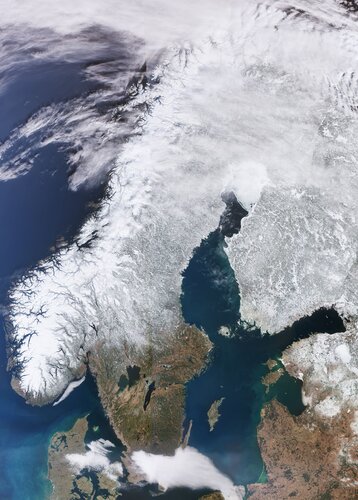
The Copernicus Sentinel-3 mission captured this impressive shot of the almost cloud-free Scandinavian Peninsula on 20 March.
Capella Space Announces New Data Products to Automate SAR Imagery Analysis Via Its Image-Tasking Console
14.4.2022 20:39 GISCafe.com Webcasts-Webinars SAN FRANCISCO, April 14, 2022 — (PRNewswire) — Capella Space, an information services company that provides high-quality Earth …The Ultimate UAV (Drones) Technologies Overview 2022 by Intetics Tech Geeks Now Available
14.4.2022 20:39 GISCafe.com Webcasts-Webinars NAPLES, Fla., April 14, 2022 (GLOBE NEWSWIRE) -- Regulators and manufacturers are incorporating drones into everyday consumers' lives. There are …ASTERRA Leaders to Attend GEOINT
14.4.2022 20:39 GISCafe.com Webcasts-Webinars SAN DIEGO, April 14, 2022 (GLOBE NEWSWIRE) -- ASTERRA will have a strong presence at the United States Geospatial Intelligence Foundation Symposium …Carahsoft Hosts Partner Pavilion at 2022 GEOINT Symposium in Aurora, Colorado, April 24-27, 2022
14.4.2022 20:39 GISCafe.com Webcasts-Webinars RESTON, Va., April 14, 2022 (GLOBE NEWSWIRE) -- WHAT: Carahsoft Technology Corp., The Trusted Government IT Solutions Provider®, will be …Bentley Systems Brings Construction Engineering Projects to Life with NVIDIA CloudXR
14.4.2022 20:08 Bentley SystemsVR do 14.5
14.4.2022 13:04 ČÚZK - předpisy a opatření Katastrální úřad pro hlavní město Prahu - Katastrální pracoviště Praha zveřejnil novou aktualitu: Ředitelka úřadu vyhlašuje výběrové řízení na služební místo:* rada/odborný rada – právník
VR do 14.5
14.4.2022 13:04 ČÚZK /Urady/Katastralni-urady/Katastralni-urady/Katastralni-urad-pro-hlavni-mesto-Prahu/O-uradu/Aktuality/VR-do-14-5VR do 31.5
14.4.2022 13:04 ČÚZK - předpisy a opatření Katastrální úřad pro hlavní město Prahu - Katastrální pracoviště Praha zveřejnil novou aktualitu: Ředitelka úřadu vyhlašuje výběrové řízení na služební místo:odborný referent/vrchní referent – revize katastrálního operátu
VR do 03.8
14.4.2022 13:04 ČÚZK - předpisy a opatření Katastrální úřad pro hlavní město Prahu - Katastrální pracoviště Praha zveřejnil novou aktualitu: Ředitelka úřadu vyhlašuje výběrové řízení na služební místo:odborný referent/vrchní referent – revize katastrálního operátu
VR do 14.5
14.4.2022 13:04 ČÚZK - předpisy a opatření Katastrální úřad pro hlavní město Prahu - Katastrální pracoviště Praha zveřejnil novou aktualitu: Ředitelka úřadu vyhlašuje výběrové řízení na služební místo:* rada/odborný rada – právní POI.
VR do 31.5
14.4.2022 13:04 ČÚZK - předpisy a opatření Katastrální úřad pro hlavní město Prahu - Katastrální pracoviště Praha zveřejnil novou aktualitu: Ředitelka úřadu vyhlašuje výběrové řízení na služební místo:* rada/odborný rada – právník
VR do 31.5
14.4.2022 13:04 ČÚZK /Urady/Katastralni-urady/Katastralni-urady/Katastralni-urad-pro-hlavni-mesto-Prahu/O-uradu/Aktuality/VR-do-14-5VR do 03.8
14.4.2022 13:04 ČÚZK /Urady/Katastralni-urady/Katastralni-urady/Katastralni-urad-pro-hlavni-mesto-Prahu/O-uradu/Aktuality/VR-do-14-5rada/odborný rada – právník (PO I.)
14.4.2022 13:01 ČÚZK /Urady/Katastralni-urady/Katastralni-urady/Katastralni-urad-pro-hlavni-mesto-Prahu/Uredni-deska/Oznameni-a-jina-uredni-sdeleni/Volna-mista/DMS/rada-odborny-rada-–-pravnikrada/odborný rada – právník (PO I.)
14.4.2022 13:01 ČÚZK - předpisy a opatření Katastrální úřad pro hlavní město Prahu - Katastrální pracoviště Prahavypisuje výběrové řízení na místo
rada/odborný rada – právník (PO I.)
rada/odborný rada – právník (PO I.)
14.4.2022 13:01 ČÚZK - volná místa Katastrální úřad pro hlavní město Prahu - Katastrální pracoviště Praha vypisuje výběrové řízení na místo rada/odborný rada – právník (PO I.)
Nové číslo GaKO
14.4.2022 12:23
ÚGKK SR
Nové číslo časopisu Geodetického a Kartografického Obzoru 04/2022
Join online: Earth Observation Industry Day 13 May
14.4.2022 11:07 ESA Observing the Earth
Earth Observation Industry Day
Join online and learn about ESA's Ministerial Council plans for TRUTHS and FutureEO, 13 May
Interview with Marie-Pierre Boutin, Sales & Marketing Director, PlanetObserver
14.4.2022 9:00 GISCafe.com Webcasts-WebinarsSatellites improve national reporting of greenhouse gases
14.4.2022 9:00 ESA Observing the Earth
With the climate crisis continuing to tighten its grip, nations around the world are making efforts to reduce emissions of climate warming gases. To track action, countries report their greenhouse gas emissions to the UNFCCC – the body responsible for driving global action to combat climate change. While accurate and consistent reporting is crucial, very few countries exploit Earth observation satellite data to check and improve their estimates. Scientists have now devised new ways of comparing national greenhouse gas inventories with independent measurements taken from space.