


![]()

zprávy
zdroje zpráv:VR do 1.6
22.4.2022 13:49 ČÚZK - předpisy a opatření Katastrální úřad pro hlavní město Prahu - Katastrální pracoviště Praha zveřejnil novou aktualitu: Ředitelka úřadu vyhlašuje výběrové řízení na služební místo:* vrchní referent/rada – návrh zápisu, kontrola a zplatnění
* vrchní referent/rada – kontrola listin určených k záznamu
Vrchní referent/rada – Rozpočtář – veřejné zakázky
22.4.2022 13:34 ČÚZK - předpisy a opatření Český úřad zeměměřický a katastrálnívypisuje výběrové řízení na místo
Vrchní referent/rada – Rozpočtář – veřejné zakázky
Vrchní referent/rada – Rozpočtář – veřejné zakázky
22.4.2022 13:34 ČÚZK - volná místa Český úřad zeměměřický a katastrální vypisuje výběrové řízení na místo Vrchní referent/rada – Rozpočtář – veřejné zakázkyKey findings from the European State of the Climate Report
22.4.2022 12:45 ESA Observing the Earth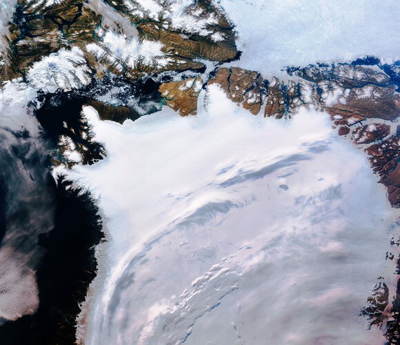
Europe experienced its warmest summer on record in 2021, accompanied by severe floods in western Europe and dry conditions in the Mediterranean. These are just some of the key findings from the Copernicus Climate Change Service’s European State of the Climate report released today. The in-depth report provides key insights and a comprehensive analysis of climate conditions in 2021, with a special focus on Europe and the Arctic.
Key findings from the European State of the Climate Report
22.4.2022 12:45 ESA Observing the Earth
Europe experienced its warmest summer on record in 2021, accompanied by severe floods in western Europe and dry conditions in the Mediterranean. These are just some of the key findings from the Copernicus Climate Change Service’s European State of the Climate report released today. The in-depth report provides key insights and a comprehensive analysis of climate conditions in 2021, with a special focus on Europe and the Arctic.
20220422_Odborný referent oddělení dokumentace KN
22.4.2022 11:04 ČÚZK - předpisy a opatření Katastrální úřad pro Středočeský kraj - Katastrální pracoviště Praha-západ Vyhlášení výběrového řízení: Odborný referent oddělení dokumentace KN V části "Úřední deska", v sekci "Oznámení a jiná úřední sdělení" bylo vystaveno "Oznámení o vyhlášení výběrového řízení na obsazení služebního místa Odborný referent oddělení dokumentace KN "20220422_Odborný referent oddělení dokumentace KN
22.4.2022 11:04 ČÚZK /Urady/Katastralni-urady/Katastralni-urady/Katastralni-urad-pro-Stredocesky-kraj/Katastralni-pracoviste/KP-Kladno/O-uradu/Aktuality/20210922_Odborny-referent-oddeleni-aktualizace-(7)Odborný referent oddělení dokumentace KN
22.4.2022 11:02 ČÚZK - předpisy a opatření Katastrální úřad pro Středočeský kraj - Katastrální pracoviště Kladnovypisuje výběrové řízení na místo Odborný referent oddělení dokumentace KN
Odborný referent oddělení dokumentace KN
Odborný referent oddělení dokumentace KN
22.4.2022 11:02 ČÚZK - volná místa Katastrální úřad pro Středočeský kraj - Katastrální pracoviště Kladno vypisuje výběrové řízení na místo Odborný referent oddělení dokumentace KN20220425-ÚOOZI
22.4.2022 10:46 ČÚZK - předpisy a opatření Český úřad zeměměřický a katastrální zveřejnil novou aktualitu: Zkoušky ÚOZI se budou konat dne 11. května 2022.20220425-ÚOOZI
22.4.2022 10:46 ČÚZK - aktuality v resortu Zkoušky ÚOZI se budou konat dne 11. května 2022.20220425-ÚOOZI
22.4.2022 10:46 ČÚZK - předpisy a opatření Český úřad zeměměřický a katastrální zveřejnil novou aktualitu: Zkoušky ÚOZI se budou konat dne 11. května 2022.20220425-ÚOOZI
22.4.2022 10:46 ČÚZK - aktuality v resortu Zkoušky ÚOZI se budou konat dne 11. května 2022.20220425-ÚOOZI
22.4.2022 10:46 ČÚZK - předpisy a opatření Český úřad zeměměřický a katastrální zveřejnil novou aktualitu: Zkoušky ÚOZI se budou konat dne 11. května 2022.20220422-Výběrové řízení KP Ústí nad Labem
22.4.2022 10:38 ČÚZK - aktuality v resortu Oznámení o vyhlášení výběrového řízení na obsazení služebního místa ředitele/ ředitelky Katastrálního pracoviště Ústí nad Labem.20220422-Výběrové řízení KP Ústí nad Labem
22.4.2022 10:38 ČÚZK - předpisy a opatření Český úřad zeměměřický a katastrální zveřejnil novou aktualitu: Oznámení o vyhlášení výběrového řízení na obsazení služebního místa ředitele/ ředitelky Katastrálního pracoviště Ústí nad Labem.20220422-Výběrové řízení KP Ústí nad Labem
22.4.2022 10:38 ČÚZK /Aktuality-resort/2022/20220422-Vyberove-rizeni-KP-Usti-nad-LabemEarth from Space: Earth Day
22.4.2022 10:00 ESA Observing the Earth
Each year on 22 April, people across the planet join forces to raise awareness about the depleting quality of the environment, the unequivocal effects of climate change and the importance of protecting our planet for future generations. We celebrate Earth Day every day at ESA. This week, this spectacular image of Earth is brought to you by the Meteosat Second Generation series of missions.
St. Louis Comes Together to Announce the Taylor Geospatial Institute
22.4.2022 9:00 GISCafe.com Webcasts-Webinars Institute Brings Together Eight Midwest Research Institutions, Implements Key Component of GeoFutures Strategic Roadmap
“This institute …
Bentley Systems to Announce First Quarter 2022 Operating Results; Presenting at Upcoming Investor Conferences
22.4.2022 9:00 GISCafe.com Webcasts-Webinars EXTON, Pa. — (BUSINESS WIRE) — April 19, 2022 — Bentley Systems, Incorporated (Nasdaq: BSY), the infrastructure engineering …CHC Navigation introduces the AlphaAir 1400 and AlphaAir 2400 Airborne LiDAR Series
22.4.2022 9:00 GISCafe.com Webcasts-Webinars Advanced airborne laser scanners impress with their combination of lightweight, long-range, high accuracy, and scanning speed.Shanghai, China …
Juniper Systems Inc. launches next-generation Geode™ GNS3 GNSS Receiver
22.4.2022 9:00 GISCafe.com Webcasts-Webinars More accuracy. More options.Logan, UT – Juniper Systems is excited to introduce the all-new Geode™ GNS3 GNSS Receiver. The Geode GNS3 …
BlackSky to Host First Quarter 2022 Results Conference Call
22.4.2022 9:00 GISCafe.com Webcasts-Webinars HERNDON, Va. — (BUSINESS WIRE) — April 20, 2022 — BlackSky Technology Inc. (“BlackSky” or the “Company”) …AsteRx-U3: ruggedized GNSS receiver for demanding applications
22.4.2022 9:00 GISCafe.com Webcasts-Webinars High-accuracy positioning receiver offers versatile connectivity and access to all the latest GNSS satellites and signalsLeuven, Belgium – …
Přerušení dodávky elektřiny 28.4.2022
22.4.2022 8:32 ČÚZK /Urady/Katastralni-urady/Katastralni-urady/Katastralni-urad-pro-Moravskoslezsky-kraj/Katastralni-pracoviste/KP-Novy-Jicin/O-uradu/Aktuality/Preruseni-dodavky-elektriny-28-4-2022Přerušení dodávky elektřiny 28.4.2022
22.4.2022 8:32 ČÚZK - předpisy a opatření Katastrální úřad pro Moravskoslezský kraj - Katastrální pracoviště Nový Jičín zveřejnil novou aktualitu: Ve čtvrtek dne 28. dubna 2022 v době od 11:00 hodin do 14:00 hodin bude přerušena dodávka elektřiny v budově Katastrálního pracoviště Nový Jičín.Z uvedeného důvodu bude provoz pracoviště omezen pouze na podání vkladu do katastru. Úhradu správního poplatku je možné provést v hotovosti, převodem z účtu nebo kolkovou známkou.
ZABAGED® - aktualizace
22.4.2022 8:05 ČÚZK - Geoportál ZABAGED® - aktualizaceZačátkem dubna 2022 byly zpřístupněny uživatelům zaktualizované sady těchto typů objektů ZABAGED®: definiční body adresních míst, hranice správních jednotek a katastrálních území společně s definičními body správních celků, včetně aktualizace státní hranice, školy, školská zařízení, maloplošné a velkoplošné zvláště chráněné území, lanová dráha, stožáry lanové dráhy a lyžařské vleky. Průběžně byly během celého období aktualizovány definiční čáry ulic podle návrhu obcí současně s definičními body náměstí.
V 1. čtvrtletí 2022 byla dokončena plošná aktualizace ZABAGED® na celém území mapových listů Základní topografické mapy ČR 1:50 000: 0305-A, 0306-C, 0608-D, 0708-B a dále byla dokončena na vybraných částech území mapových listů Základní topografické mapy ČR 1:50 000: 0608-A.
V 1. čtvrtletí 2022 byly v rámci zpřesňování stavebních objektů v ZABAGED® (na podkladě existující kresby v ISKN, Ortofota ČR, výstupů z dat leteckého laserového skenování a dalších dostupných zdrojů) aktualizovány budovy a další stavební objekty v okresech Bruntál, České Budějovice, Hradec Králové, Chomutov, Chrudim, Jeseník, Jindřichův Hradec, Karlovy Vary, Kolín, Mělník, Mladá Boleslav, Most, Olomouc, Praha-východ, Rychnov nad Kněžnou, Šumperk.
Více informací o stavu aktualizace je uvedeno v tabulce Informace o produktu, v oddíle Aktualizační cyklus - stav aktualizace.
Maxar European Space Imaging: Ukraine Russian Imagery update 19 March – 03 April 2022
22.4.2022 0:26 GISCafe.com Webcasts-Webinars Recent very high resolution satellite imagery collected by European Space Imaging and its partner Maxar reveals the existence of a mass grave site on …LuminWave Raises More Than $20 Million in Series B Financing to Accelerate the Development of Si Photonics FMCW 4D LiDAR
21.4.2022 19:16 GISCafe.com Webcasts-Webinars HANGZHOU, China — (BUSINESS WIRE) — April 20, 2022 —LuminWave, a Si photonics FMCW 4D LiDAR pioneer announced it has raised more …
Výstava Dědictví zmizelých krajin Česka II [Katedra aplikované geoinformatiky a kartografie, byTopic]
21.4.2022 17:05 Katedra aplikované geoinformatiky a kartografie Přf UK Od 17. 5. do 31. 8. 2022 se bude v budově PřF UK Albertov 6, ve 2. patře v předsálí Mapové sbírky konat výstava Dědictví zmizelých krajin Česka II.Aeva 4D LiDAR Helps NASA Map the Moon
21.4.2022 16:03 GISCafe.com Webcasts-Webinars Aeva’s Technology Solves Critical Challenges for Lunar Exploration by Enabling High Resolution Mapping and Precise Navigation in GPS-denied …BlackSky Upgrades Customers’ Site Monitoring Experience with Enhanced Analytics and Imaging Capabilities
21.4.2022 16:03 GISCafe.com Webcasts-Webinars New features give users the ability to extract additional intelligence over sites of economic interest worldwideHERNDON, Va. — (BUSINESS WIRE) …
Planet Unveils Details About Pelican
21.4.2022 16:03 GISCafe.com Webcasts-Webinars A Next-Generation Satellite Constellation for Very-High-Resolution and Rapid-Revisit CapabilitiesSAN FRANCISCO — (BUSINESS WIRE) — April …
AgEagle to Exhibit at AUVSI XPONENTIAL 2022 in Orlando, Florida
21.4.2022 16:03 GISCafe.com Webcasts-Webinars WICHITA, Kan., April 21, 2022 (GLOBE NEWSWIRE) -- AgEagle Aerial Systems Inc. (NYSE American: UAVS) (“AgEagle” or the “Company”), an …Nástroj pro bezpečnost ArcGIS Enterprise
21.4.2022 13:47 ARCDATASledovat vydávání patchů pro ArcGIS Enterprise, reagujících na nejrůznější bezpečnostní hrozby (jako nedávná Log4j, ke které všechny aktuální informace naleznete na stránce ArcGIS and Apache Log4j Vulnerabilities) vám pomůže nástroj patchnotification. Je součástí standardní instalace ArcGIS Enterprise a vedle e-mailových notifikací a nových oznámení na stránce Patches and Service Packs je další metodou, jak zajistit, aby váš systém byl zabezpečený.
Na stránkách Esri si můžete přečíst podrobný návod, jak nástroj patchnotification používat.

Dokumentace k JVF DTM verze 1.4.2
21.4.2022 12:54 ČÚZK - předpisy a opatření Do záložky JVF DTM byla přidána dokumentace Jednotného výměnného formátu DTM verze 1.4.2, která byla dne 4. dubna 2022 schválena Koordinační radou správců DMVS a DTM.Import VFK verze 6.0 do programu GEUS
21.4.2022 12:41 GEUSware Od 18.4.2022 KP vydávají soubory VFK verze 6.0 v kódování UTF-8. Vzhledem k častým dotazům jsme připravili shrnutí, jak tato změna dopadá na uživatele programu GEUS.Odborný referent / vrchní referent – poskytování informací KN, poskytování podkladů, nahlížení do KN
21.4.2022 11:41 ČÚZK - volná místa Katastrální úřad pro Zlínský kraj Katastrální pracoviště Zlín vypisuje výběrové řízení na místo Odborný referent / vrchní referent – poskytování informací KN, poskytování podkladů, nahlížení do KNOdborný referent / vrchní referent – poskytování informací KN, poskytování podkladů, nahlížení do KN
21.4.2022 11:41 ČÚZK - předpisy a opatření Katastrální úřad pro Zlínský kraj Katastrální pracoviště Zlínvypisuje výběrové řízení na místo
Odborný referent / vrchní referent – poskytování informací KN, poskytování podkladů, nahlížení do KN, poskytování informací PK v oddělení dokumentace KN Katastrálního pracoviště Zlín
EUSPA: the gatekeeper to a secure EU Space Programme
21.4.2022 11:15 European GNSS Agency
Speaking at CYSAT, EUSPA highlighted how its security apparatus helps protect the space-based data we depend on against malicious cyberattacks.
The number of critical services and everyday devices that depend on satellite-based data continues to increase. But with this increase comes new challenges – including cybersecurity.
Satellites have historically been designed to be reliable - but not necessarily secure. This, in combination with recent trends towards software-defined satellites, in-orbit reconfigurations, and quantum technologies, means space assets and data are now more vulnerable to cyberattacks than ever before.
“Ensuring the confidentiality, integrity and availability of space data against cyber threats is a new challenge that we simply cannot afford to ignore,” said Philippe Rosius, Head of Galileo Security Monitoring centre (GSMC) at the European Union Agency for the Space Programme (EUSPA).
According to Rosius, who made his remarks at CYSAT (the European event dedicated to cybersecurity for the space industry) EUSPA is uniquely positioned to serve as the security gatekeeper of the EU Space Programme. “In addition to its service provision, EUSPA is responsible for ensuring that Europe’s GNSS signals are secure,” he said. “It also provides security expertise and support for the Space Programme’s other components, including GOVSATCOM, as well as to various European Commission initiatives.”
Specifically, the EUSPA security organisation provides the cybersecurity and engineering competence for all programme components. “Our security engineering and cybersecurity work defines and implements the security requirements related to the services, the systems, and their operations,” explained Rosius.
The Security Authority also oversees the operational security of European GNSS (Galileo and EGNOS). “Here our work focuses on ensuring that the systems in operation comply with the general security requirements established using a threat and risk analysis,” added Rosius.
An integral part of the Galileo infrastructure
Security monitoring is done by the Galileo Security Monitoring Centre (GSMC).
“The GSMC is an integral part of the Galileo infrastructure and has the competence to be extended to other Space Programme’s components,” said Rosius.
From its sites in France and Spain, the GSMC monitors and, when necessary, takes action regarding security threats, security alerts and the operational status of Galileo’s various components. It is also responsible for managing access to the Public Regulated Service (PRS) and ensures that sensitive information relating to its use is properly managed and protected.
“In the event of a security threat to the security of systems and services deployed, operated and used under the Union Space Programme which may affect the security of the Union, the European Council issues specific instructions to EUSPA, which the GSMC is responsible for implementing,” explained Rosius.
The EU Space Programme’s security accreditation authority
If the Security authority and GSMC make EUSPA the security gatekeeper of the EU Space Programme, then security assurance is finally ensured by the Security Accreditation Board (SAB). “The SAB is the security accreditation authority for all of the EU Space Programme’s components,” said SAB Chair Bruno Vermeire, who also spoke during CYSAT. “In this role, it ensures that all systems comply with the relevant security requirements, including Cyber and Supply Chain, and provides statements of approval to operate for the systems and services.”
An independent body within EUSPA, the SAB is composed of a representative from each Member State, the Commission and from the High Representative for the Union for Foreign Affairs and Security Policy. The Board is charged with:
- Defining and approving security accreditation strategies
- Approving satellite launches
- Authorising the operation of systems in different configurations and for various services
- Authorising the operation of ground stations
- Authorising bodies to develop or manufacture sensitive PRS technologies, receivers and security modules
- Endorsing the selection of approved products
- Approving interconnections between systems
The SAB makes its decisions in an independent manner, including in regard to the Commission and other bodies responsible for implementing the components and provision of service.
“Thanks to this robust security apparatus, EUSPA is at the front lines of cybersecurity, providing end users with the confidence of knowing that the space-derived data they depend on is safe and secure,” concluded Vermeire.
Media note: This feature can be republished without charge provided the European Union Agency for the Space Programme (EUSPA) is acknowledged as the source at the top or the bottom of the story. You must request permission before you use any of the photographs on the site. If you republish, we would be grateful if you could link back to the EUSPA website (http://www.euspa.europa.eu).
Oznámení o výběru zástupu na služební místo vrchní referent/rada – kontrola aktualizace KA1301
21.4.2022 9:45 ČÚZK - volná místa Katastrální úřad pro Plzeňský kraj Katastrální pracoviště Rokycany vypisuje výběrové řízení na místo Oznámení o výběru zástupu na služební místo vrchní referent/rada – kontrola aktualizace KA1301Oznámení o výběru zástupu na služební místo vrchní referent/rada – kontrola aktualizace KA1301
21.4.2022 9:45 ČÚZK /Urady/Katastralni-urady/Katastralni-urady/Katastralni-urad-pro-Plzensky-kraj/Uredni-deska/Oznameni-a-jina-uredni-sdeleni/Volna-mista/DMS/Oznameni-o-vyberu-zastupu-na-sluzebni-misto-vrchniOznámení o výběru zástupu na služební místo vrchní referent/rada – kontrola aktualizace KA1301
21.4.2022 9:45 ČÚZK - předpisy a opatření Katastrální úřad pro Plzeňský kraj Katastrální pracoviště Rokycanyvypisuje výběrové řízení na místo
Oznámení o výběru zástupu na služební místo vrchní referent/rada – kontrola aktualizace KA1301
Aergility to Unveil ATLIS Hybrid Cargo VTOL UAV at XPONENTIAL 2022
21.4.2022 0:56 GISCafe.com Webcasts-Webinars ORLANDO, Fla., April 20, 2022 — (PRNewswire) — Aergility Corporation announced today that it will be unveiling its full-scale ATLIS …Moody’s and Planet Form Strategic Relationship
20.4.2022 18:29 GISCafe.com Webcasts-Webinars Firms join forces to drive transparency on sustainability issues facing financial markets, leveraging high-cadence geospatial dataSAN FRANCISCO …
Planet Joins ESA Third Party Mission Programme for Open Access to High-Frequency, High-Resolution Imagery
20.4.2022 18:29 GISCafe.com Webcasts-Webinars BERLIN — (BUSINESS WIRE) — April 20, 2022 —Planet Labs PBC (NYSE: PL), a leading provider of daily data and insights about Earth, …
Velodyne Lidar Showcases Full Stack Vision Solutions for Robotics, Industrial and Trucking at XPONENTIAL 2022
20.4.2022 18:29 GISCafe.com Webcasts-Webinars Velodyne’s Christina Aizcorbe Featured Speaker on Commercialization of Automated TruckingSAN JOSE, Calif. — (BUSINESS WIRE) — April …
Quanergy and Mirasys Integrate 3D LiDAR and Deep Vision Data Platforms to Provide Advanced Security
20.4.2022 18:29 GISCafe.com Webcasts-Webinars The 3D LiDAR and VMS integration delivers advanced insights and analytics for physical security applications in the government, retail, and gaming …Maxar Extends 3D Geospatial Capabilities Through Partnership with Blackshark.ai
20.4.2022 18:29 GISCafe.com Webcasts-Webinars Maxar’s strategic investment layers its best-in-class satellite imagery with Blackshark.ai’s semantic 3D geospatial platformWESTMINSTER, Colo. …
PAR Government Teams Up with BlackSky to Deliver Commercial Near Real-Time Imagery to the Tactical Edge
20.4.2022 18:29 GISCafe.com Webcasts-Webinars GEOINT 2022 attendees invited to experience Sit(x) demo featuring analytics of UkraineNEW HARTFORD, N.Y. — (BUSINESS WIRE) — April 20, …
Esri Brings Powerful Mapping Technology to Everyone with New Storytelling Tool
20.4.2022 18:29 GISCafe.com Webcasts-Webinars StoryMaps Allows Content Creators to Unify Digital Experiences in One Place Furthering Esri's Mission to Bring the Geographic Approach to …Iris Automation Launches Ground-based Surveillance System, Casia G
20.4.2022 18:29 GISCafe.com Webcasts-Webinars RENO, Nev., April 20, 2022 — (PRNewswire) — Addressing the need for large-scale, safe uncrewed aviation, Iris Automation announces …Draganfly to Speak at Law-Tech Connect™ Workshop During AUVSI XPONENTIAL 2022
20.4.2022 18:29 GISCafe.com Webcasts-Webinars Los Angeles, CA., April 20, 2022 (GLOBE NEWSWIRE) -- Draganfly Inc. (NASDAQ: DPRO) (CSE: DPRO) (FSE: 3U8) (“Draganfly” or the “Company”), …Q3 FY22: Nearmap Achieves Record Quarter for Government Portfolio in North America
20.4.2022 18:29 GISCafe.com Webcasts-Webinars Generates US$2 million incremental annual contract value in a single quarter in North America for government sector aloneIncremental revenue …NYSDOT Industrializes East 138th Street Bridge Using Digital Twin
20.4.2022 18:29 Bentley SystemsPressCoverage
Informed Infrastructure, USA
Read the articleWIDENING FLORIDAS I-10 FDOT REVITALIZES A PRIMARY HURRICANE EVACUATION ROUTE
20.4.2022 18:21 Bentley SystemsPressCoverage
Roads and Bridges, USA
Read the articleDesigning Steel Connections from Your Structural Analysis Program
20.4.2022 18:05 Bentley SystemsPressCoverage
Structural Engineer, USA
Read the articleUnlocking the value in digital information
20.4.2022 17:48 Bentley SystemsPressCoverage
Oil Review Middle East, Middle East
Read the articleThe Moon – where no satnav has gone before
20.4.2022 15:29 ESA Navigation
The test version of a unique satellite navigation receiver has been delivered for integration testing on the Lunar Pathfinder spacecraft. The NaviMoon satnav receiver is designed to perform the furthest ever positioning fix from Earth, employing signals that will be millions of times fainter than those used by our smartphones or cars.
The Moon – where no satnav has gone before
20.4.2022 15:29 ESA Navigation
The test version of a unique satellite navigation receiver has been delivered for integration testing on the Lunar Pathfinder spacecraft. The NaviMoon satnav receiver is designed to perform the farthest ever positioning fix from Earth, employing signals that will be millions of times fainter than those used by our smartphones or cars.
Weather satellite prepares for lightning
20.4.2022 11:34 ESA Observing the Earth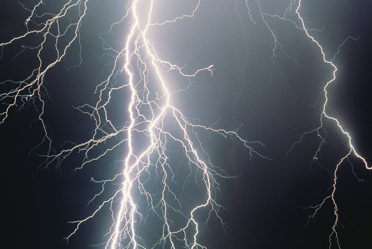
As one of the last milestones before liftoff at the end of the year, the first Meteosat Third Generation weather satellite is being fitted with its Lightning Imager. From geostationary orbit, 36 000 km above Earth’s surface, this state-of-the-art European instrument will continuously monitor lightning over more than 80% of Earth’s disc for early warnings of dangerous storms. Remarkably, it is capable of imaging relatively weak lightning events in full sunlight.
Referent/ka zeměměřictví a katastr nemovitostí
20.4.2022 11:24 Zeměměřický úřad Zeměměřický úřadvypisuje výběrové řízení na místo
Referent/ka zeměměřictví a katastr nemovitostí
Referent/ka zeměměřictví a katastr nemovitostí
20.4.2022 11:24 ČÚZK /Urady/Zememericky-urad/Volna-mista/Referent-ka-zememerictvi-a-katastr-nemovitostiReferent/ka zeměměřictví a katastr nemovitostí
20.4.2022 11:24 ČÚZK - předpisy a opatření Zeměměřický úřadvypisuje výběrové řízení na místo
Referent/ka zeměměřictví a katastr nemovitostí
Referent/ka zeměměřictví a katastr nemovitostí
20.4.2022 11:24 ČÚZK - volná místa Zeměměřický úřad vypisuje výběrové řízení na místo Referent/ka zeměměřictví a katastr nemovitostíGeodet/ka
20.4.2022 11:23 ČÚZK /Urady/Zememericky-urad/Uredni-deska/Oznameni-a-jina-uredni-sdeleni/Volna-mista/Geodet-ka-(2)Geodet/ka
20.4.2022 11:23 ČÚZK - volná místa Zeměměřický úřad vypisuje výběrové řízení na místo Geodet/kaGeodet/ka
20.4.2022 11:23 ČÚZK - předpisy a opatření Zeměměřický úřadvypisuje výběrové řízení na místo
Geodet/ka
Geodet/ka
20.4.2022 11:23 Zeměměřický úřad Zeměměřický úřadvypisuje výběrové řízení na místo
Geodet/ka
ESKN - problém s elektronickým podpisovaním
20.4.2022 10:57 ÚGKK SRNávod na riešenie problému s elektronickým podpisovaním na Portáli ESKN súvisiaci s ochranou HTTPS komunikácie vo webovom prehliadači a antivírovým softvérom
ESKN - problém s elektronickým podpisovaním
20.4.2022 10:57
ÚGKK SR
Návod na riešenie problému s elektronickým podpisovaním na Portáli ESKN súvisiaci s ochranou HTTPS komunikácie vo webovom prehliadači a antivírovým softvérom
ESKN - problém s elektronickým podpisovaním
20.4.2022 10:57
ÚGKK SR
Návod na riešenie problému s elektronickým podpisovaním na Portáli ESKN súvisiaci s ochranou HTTPS komunikácie vo webovom prehliadači a antivírovým softvérom
buildingSMART International announces the sad passing of Richard Petrie
20.4.2022 10:55 buildingSMART.orgRichard Petrie and his son Michael Dear buildingSMART Community, It is with deep sadness that we inform you of the passing Richard Petrie on April 17th, 2022, following a short illness. Richard was the Chief Executive of buildingSMART International and leaves behind his wife Jane and three adult children, Michael, Maddie, and Lottie. On behalf…
The post buildingSMART International announces the sad passing of Richard Petrie appeared first on buildingSMART International.
buildingSMART International announces the sad passing of Richard Petrie
20.4.2022 10:55 buildingSMART.orgRichard Petrie and his son Michael Dear buildingSMART Community, It is with deep sadness that we inform you of the passing Richard Petrie on April 17th, 2022, following a short…
The post buildingSMART International announces the sad passing of Richard Petrie appeared first on buildingSMART International.
Upozornenie na pripravované odstavenie Katastrálneho portálu KaPor
20.4.2022 10:52
ÚGKK SR
Upozornenie na pripravované odstavenie - ukončenie prevádzky - Katastrálneho portálu /KaPor/ k 30.04.2022
Upozornenie na pripravované odstavenie Katastrálneho portálu KaPor
20.4.2022 10:52
ÚGKK SR
Upozornenie na pripravované odstavenie - ukončenie prevádzky - Katastrálneho portálu /KaPor/ k 30.04.2022
Upozornenie na pripravované odstavenie Katastrálneho portálu KaPor
20.4.2022 10:52 ÚGKK SRUpozornenie na pripravované odstavenie - ukončenie prevádzky - Katastrálneho portálu /KaPor/ k 30.04.2022
odborný/vrchní referent – personalista/ka v kanceláři ředitele Katastrálního úřadu pro Jihočeský kra
20.4.2022 9:46 ČÚZK /Urady/Katastralni-urady/Katastralni-urady/Katastralni-urad-pro-Jihocesky-kraj/Uredni-deska/Oznameni-a-jina-uredni-sdeleni/Volna-mista/DMS/odborny-vrchni-referent-–-personalista-ka-v-kancelodborný/vrchní referent – personalista/ka v kanceláři ředitele Katastrálního úřadu pro Jihočeský kra
20.4.2022 9:46 ČÚZK - volná místa Katastrální úřad pro Jihočeský kraj kancelář ředitele vypisuje výběrové řízení na místo odborný/vrchní referent – personalista/ka v kanceláři ředitele Katastrálního úřadu pro Jihočeský kraodborný/vrchní referent – personalista/ka v kanceláři ředitele Katastrálního úřadu pro Jihočeský kra
20.4.2022 9:46 ČÚZK - předpisy a opatření Katastrální úřad pro Jihočeský kraj kancelář ředitelevypisuje výběrové řízení na místo
odborný/vrchní referent – personalista/ka v kanceláři ředitele Katastrálního úřadu pro Jihočeský kraj
ZABAGED® - aktualizace
20.4.2022 9:05 ČÚZK - Geoportál ZABAGED® - aktualizaceZačátkem dubna 2022 byly zpřístupněny uživatelům zaktualizované sady těchto typů objektů ZABAGED®: definiční body adresních míst, hranice správních jednotek a katastrálních území společně s definičními body správních celků, včetně aktualizace státní hranice, školy, školská zařízení, maloplošné a velkoplošné zvláště chráněné území, lanová dráha, stožáry lanové dráhy a lyžařské vleky. Průběžně byly během celého období aktualizovány definiční čáry ulic podle návrhu obcí současně s definičními body náměstí.
V 1. čtvrtletí 2022 byla dokončena plošná aktualizace ZABAGED® na celém území mapových listů Základní topografické mapy ČR 1:50 000: 0305-A, 0306-C, 0608-D, 0708-B a dále byla dokončena na vybraných částech území mapových listů Základní topografické mapy ČR 1:50 000: 0608-A.
V 1. čtvrtletí 2022 byly v rámci zpřesňování stavebních objektů v ZABAGED® (na podkladě existující kresby v ISKN, Ortofota ČR, výstupů z dat leteckého laserového skenování a dalších dostupných zdrojů) aktualizovány budovy a další stavební objekty v okresech Bruntál, České Budějovice, Hradec Králové, Chomutov, Chrudim, Jeseník, Jindřichův Hradec, Karlovy Vary, Kolín, Mělník, Mladá Boleslav, Most, Olomouc, Praha-východ, Rychnov nad Kněžnou, Šumperk.
Více informací o stavu aktualizace je uvedeno v tabulce Informace o produktu, v oddíle Aktualizační cyklus - stav aktualizace.
Prodej automobilu Octavia v aukci na ÚZSVM
20.4.2022 9:00 ČÚZK - předpisy a opatřeníKatastrální úřad pro Liberecký kraj Prodej automobilu Octavia v aukci na ÚZSVM
Prodej automobilu Octavia v aukci na ÚZSVM
Prodej automobilu Octavia v aukci na ÚZSVM
20.4.2022 9:00 ČÚZK /Urady/Katastralni-urady/Katastralni-urady/Katastralni-urad-pro-Liberecky-kraj/Nabidky-majetku/Prodej-automobilu-Octavia-v-aukci-na-UZSVM-(2)VŘ do 19.08
20.4.2022 8:00 ČÚZK /Urady/Katastralni-urady/Katastralni-urady/Katastralni-urad-pro-hlavni-mesto-Prahu/O-uradu/Aktuality/VR-do-06-05VŘ do 06.05
20.4.2022 8:00 ČÚZK /Urady/Katastralni-urady/Katastralni-urady/Katastralni-urad-pro-hlavni-mesto-Prahu/O-uradu/Aktuality/VR-do-06-05VŘ do 19.08
20.4.2022 8:00 ČÚZK - předpisy a opatření Katastrální úřad pro hlavní město Prahu - Katastrální pracoviště Praha zveřejnil novou aktualitu: Ředitelka úřadu vyhlašuje výběrové řízení na služební místo:referent KN – návrh zápisu v katastru do PO V
VŘ do 06.05
20.4.2022 8:00 ČÚZK - předpisy a opatření Katastrální úřad pro hlavní město Prahu - Katastrální pracoviště Praha zveřejnil novou aktualitu: Ředitelka úřadu vyhlašuje výběrové řízení na služební místo:* odborný referent/vrchní referent – zápis do protokolu řízení V a Z
odborný referent/vrchní referent – zápis do protokolu řízení V a Z
20.4.2022 7:57 ČÚZK /Urady/Katastralni-urady/Katastralni-urady/Katastralni-urad-pro-hlavni-mesto-Prahu/Uredni-deska/Oznameni-a-jina-uredni-sdeleni/Volna-mista/DMS/odborny-referent-vrchni-referent-–-zapis-do-pr-(1)odborný referent/vrchní referent – zápis do protokolu řízení V a Z
20.4.2022 7:57 ČÚZK - volná místa Katastrální úřad pro hlavní město Prahu Katastrální pracoviště Praha vypisuje výběrové řízení na místo odborný referent/vrchní referent – zápis do protokolu řízení V a Zodborný referent/vrchní referent – zápis do protokolu řízení V a Z
20.4.2022 7:57 ČÚZK - předpisy a opatření Katastrální úřad pro hlavní město Prahu Katastrální pracoviště Prahavypisuje výběrové řízení na místo
odborný referent/vrchní referent – zápis do protokolu řízení V a Z
Rocket Lab Secures Multi-Launch Contract with HawkEye 360, Confirms First Launch Planned from Virginia
20.4.2022 1:08 GISCafe.com Webcasts-Webinars Rocket Lab will launch three Electron missions for HawkEye 360, the first of which is expected to be the inaugural launch from Rocket Lab Launch …EDUC letní školy
20.4.2022 0:00 Geografický ústav MUAliance EDUC pořádá letní školy na partnerských univerzitách.
Nabídky a podmínky přihlášení naleznete ZDE, termín přihlášení je do 20. dubna 2022.
Pozvánka na přednášku Zahrádkářské osady aneb proč neztrácet půdu pod nohama
20.4.2022 0:00 Geografický ústav MU
Pozvánka na přednášku Zahrádkářské osady aneb proč neztrácet půdu pod nohama
20.4.2022 0:00 Geografický ústav MUS přispěním Geografického ústavu vychází kniha Zahrádkářské osady aneb proč neztrácet půdu pod nohama, mapující přínos městského zahradničení k potravinové, sociální i environmentální resilienci.
Knihu představí dr. Petr Daněk, společně s dalšími spoluautory, na besedě v knihkupectví Academia v Brně dne 20. dubna 2022.
Bentley Systems to Announce First Quarter 2022 Operating Results Presenting at Upcoming Investor Conferences
19.4.2022 20:51 Bentley SystemsPress Announcements
TomTom’s Maps Gain Greater Visual Context from Expanded Agreement with Maxar
19.4.2022 18:40 GISCafe.com Webcasts-Webinars AMSTERDAM, April 19, 2022 (GLOBE NEWSWIRE) -- TomTom (TOM2), the geolocation technology specialist, announced that it has expanded its agreement …Booz Allen Invests in Reveal Technology, Inc.
19.4.2022 18:40 GISCafe.com Webcasts-Webinars Strengthens Firm’s Edge Analytics Capabilities, Tactical Decision Making in the Digital BattlespaceMCLEAN, Va. — (BUSINESS WIRE) — …
Drones a Step Closer to Scaling in Canadian Cities Thanks to AirMatrix
19.4.2022 18:40 GISCafe.com Webcasts-Webinars TORONTO — (BUSINESS WIRE) — April 19, 2022 —AirMatrix is pleased to announce that it has undertaken a new project to accelerate …
Dedrone Delivers First Multi-Layered Mobile AI-Powered Drone Detection Unit
19.4.2022 18:40 GISCafe.com Webcasts-Webinars DedroneRapidResponse can be deployed in under 30 minutes to ensure uninterrupted airspace protection of outdoor eventsSAN FRANCISCO — …