


![]()

zprávy
zdroje zpráv:Konference GIS Esri v ČR 2022
9.5.2022 8:24 GISportal.cz
ARCDATA Praha oznamuje a zve na letošní ročník Konference GIS Esri v ČR, která se bude konat 1. a 2. listopadu 2022 opět prezenčně. Dojde ale ke změně místa konání – z pražského Kongresového centra se kvůli předsednictví ČR v Radě EU přesuneme do prostorů Cubex Centra. Tradiční setkání českých geoinformatiků proběhne kombinovanou formou – můžete dorazit osobně, nebo si […]
The post Konference GIS Esri v ČR 2022 appeared first on GISportal.cz.
Otevření knihovny Brána vesmíru
8.5.2022 19:34 Česká kosmická kancelář
Česká kosmická kancelář shromáždila několik stovek knih, časopisů a dalších materiálů získaných z pozůstalosti našeho předního odborníka Antonína Vítka, novináře a spisovatele Karla Pacnera i z darů dalších odborníků se záměrem je uplatnit ve vzdělávacích a propagačních akcích o výzkumu kosmu.
"Autodesk Acquires Immersive Collaboration Platform, The Wild" by Sanjay Gangal
8.5.2022 13:43 GISCafe.com Webcasts-WebinarsJarní workshopy s ARCDATA PRAHA – ArcGIS StoryMaps (PR)
7.5.2022 8:07 GISportal.cz
Společnost ARCDATA PRAHA připravila jarní sérii webových seminářů, zaměřenou na nejrůznější aplikace systému ArcGIS. Vedle tipů pro práci v desktopové aplikaci se seznámíte s postupy pro publikaci vektorových dat online, způsobem, jak je vizualizovat a sdílet formou aplikací nebo interaktivních článků, a také s komplexnějším tématem použití rastrových snímků ve webovém i v desktopovém prostředí. […]
The post Jarní workshopy s ARCDATA PRAHA – ArcGIS StoryMaps (PR) appeared first on GISportal.cz.
Jarní workshopy s ARCDATA PRAHA – ArcGIS StoryMaps (PR)
7.5.2022 8:07 GISportal.czSpolečnost ARCDATA PRAHA připravila jarní sérii webových seminářů, zaměřenou na nejrůznější aplikace systému ArcGIS. Vedle tipů pro práci v desktopové aplikaci se seznámíte s postupy pro publikaci vektorových dat online, způsobem, jak je vizualizovat a sdílet formou aplikací nebo interaktivních článků, a také s komplexnějším tématem použití rastrových snímků ve webovém i v desktopovém prostředí. […]
The post Jarní workshopy s ARCDATA PRAHA – ArcGIS StoryMaps (PR) appeared first on GISportal.cz.
EOS Data Analytics contracted an agreement with GEOSAT for the exploitation of satellite data
6.5.2022 20:25 GISCafe.com Webcasts-Webinars MOUNTAIN VIEW, Calif., May 6, 2022 — (PRNewswire) — EOS Data Analytics (EOSDA), a global provider of AI-powered satellite imagery …BlackSky to Participate at the 17th Annual Needham Technology and Media Conference
6.5.2022 20:25 GISCafe.com Webcasts-Webinars HERNDON, Va. — (BUSINESS WIRE) — May 6, 2022 —BlackSky Technology Inc. (“BlackSky” or the “Company”) (NYSE: BKSY), a …
Industry Survey: The Role of openBIM in the Regulatory Process
6.5.2022 20:01 buildingSMART.orgThe Regulatory Room has published a report of a outcomes of the survey which set out to discover and analyse the general perception of openBIM adoption in the compliance processes…
The post Industry Survey: The Role of openBIM in the Regulatory Process appeared first on buildingSMART International.
Industry Survey: The Role of openBIM in the Regulatory Process
6.5.2022 20:01 buildingSMART.orgThe Regulatory Room has published a report of a outcomes of the survey which set out to discover and analyse the general perception of openBIM adoption in the compliance processes of both regulators and the regulated industry. The final goal of the assessment was to find the best messages and communications channels to improve the…
The post Industry Survey: The Role of openBIM in the Regulatory Process appeared first on buildingSMART International.

Zveřejnění obsahu informací poskytnutých na žádost dle zákona č. 106/1999 Sb. za rok 20
6.5.2022 12:46 ČÚZK - předpisy a opatření Katastrální úřad pro Karlovarský krajzveřejňuje obsah informace poskytnutých na žádost dle zákona č. 106/1999 Sb. za rok
2022
Zveřejnění obsahu informací poskytnutých na žádost dle zákona č. 106/1999 Sb. za rok 20
6.5.2022 12:46 ČÚZK /Urady/Katastralni-urady/Katastralni-urady/Katastralni-urad-pro-Karlovarsky-kraj/Casto-hledane-informace/Poskytovani-informaci-106-1999-Sb/Zverejneni-obsahu-informaci-poskytnutych-na-za-(1)/Zverejneni-obsahu-informaci-poskytnutych-na-za-(4)odborný referent/vrchní referent v oddělení právních vztahů k nemovitostem na Katastrálním pracovišt
6.5.2022 12:05 ČÚZK /Urady/Katastralni-urady/Katastralni-urady/Katastralni-urad-pro-Jihomoravsky-kraj/Uredni-deska/Oznameni-a-jina-uredni-sdeleni/Volna-mista/DMS/odborny-referent-vrchni-referent-v-oddeleni-pravniodborný referent/vrchní referent v oddělení právních vztahů k nemovitostem na Katastrálním pracovišt
6.5.2022 12:05 ČÚZK - předpisy a opatření Katastrální úřad pro Jihomoravský kraj Katastrální pracoviště Kyjovvypisuje výběrové řízení na místo
odborný referent/vrchní referent v oddělení právních vztahů k nemovitostem na Katastrálním pracovišti Kyjov
odborný referent/vrchní referent v oddělení právních vztahů k nemovitostem na Katastrálním pracovišt
6.5.2022 12:05 ČÚZK - volná místa Katastrální úřad pro Jihomoravský kraj Katastrální pracoviště Kyjov vypisuje výběrové řízení na místo odborný referent/vrchní referent v oddělení právních vztahů k nemovitostem na Katastrálním pracovištrada/odborný rada - vedoucí oddělení aktualizace PI KN na Katastrálním pracovišti Brno-město
6.5.2022 11:51 ČÚZK - předpisy a opatření Katastrální úřad pro Jihomoravský kraj Katastrální pracoviště Brno-městovypisuje výběrové řízení na místo
rada/odborný rada - vedoucí oddělení aktualizace PI KN na Katastrálním pracovišti Brno-město
rada/odborný rada - vedoucí oddělení aktualizace PI KN na Katastrálním pracovišti Brno-město
6.5.2022 11:51 ČÚZK /Urady/Katastralni-urady/Katastralni-urady/Katastralni-urad-pro-Jihomoravsky-kraj/Uredni-deska/Oznameni-a-jina-uredni-sdeleni/Volna-mista/DMS/rada-odborny-rada-vedouci-oddeleni-aktualizace-Prada/odborný rada - vedoucí oddělení aktualizace PI KN na Katastrálním pracovišti Brno-město
6.5.2022 11:51 ČÚZK - volná místa Katastrální úřad pro Jihomoravský kraj Katastrální pracoviště Brno-město vypisuje výběrové řízení na místo rada/odborný rada - vedoucí oddělení aktualizace PI KN na Katastrálním pracovišti Brno-městorada/odborný rada – vedoucí oddělení obnovy a revize KN I.
6.5.2022 10:39 ČÚZK /Urady/Katastralni-urady/Katastralni-urady/Katastralni-urad-pro-hlavni-mesto-Prahu/Uredni-deska/Oznameni-a-jina-uredni-sdeleni/Volna-mista/DMS/rada-odborny-rada-–-vedouci-oddeleni-obnovy-a-revirada/odborný rada – vedoucí oddělení obnovy a revize KN I.
6.5.2022 10:39 ČÚZK - předpisy a opatření Katastrální úřad pro hlavní město Prahu Katastrální pracoviště Prahavypisuje výběrové řízení na místo
rada/odborný rada – vedoucí oddělení obnovy a revize KN I.
rada/odborný rada – vedoucí oddělení obnovy a revize KN I.
6.5.2022 10:39 ČÚZK - volná místa Katastrální úřad pro hlavní město Prahu Katastrální pracoviště Praha vypisuje výběrové řízení na místo rada/odborný rada – vedoucí oddělení obnovy a revize KN I.20220506 - Změnový VFR 20220502_ST_Z*
6.5.2022 10:01 ČÚZK /ruian/Poskytovani-udaju-ISUI-RUIAN-VDP/Vymenny-format-RUIAN-(VFR)/Archiv-novinek-VFR/2022/20220506-Zmenovy-VFR-20220502_ST_Z20220506 - Změnový VFR 20220502_ST_Z*
6.5.2022 10:01 ČÚZK /ruian/Poskytovani-udaju-ISUI-RUIAN-VDP/Vymenny-format-RUIAN-(VFR)/Archiv-novinek-VFR/20220506-Zmenovy-VFR-20220502_ST_ZEarth from Space: Rhine River, Germany
6.5.2022 10:00 ESA Observing the Earth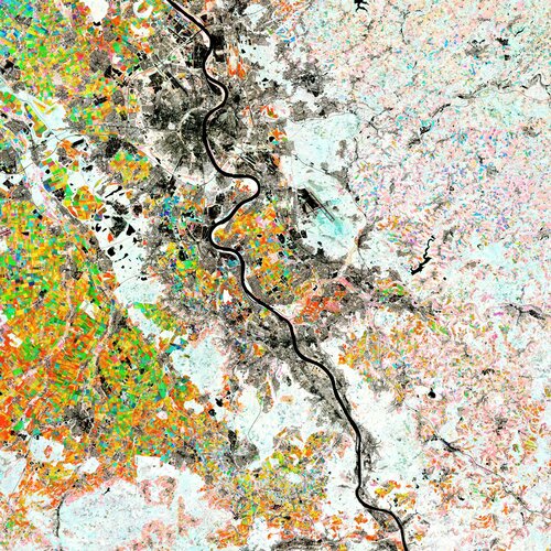
The Rhine River, the longest river in Germany, is featured in this colourful image captured by the Copernicus Sentinel-2 mission. Along this river lies the city of Bonn: the host of this year’s Living Planet Symposium – one of the largest Earth observation conferences in the world – taking place on 23–27 May 2022.
EUSPA is looking for Galileo Engineering Support
6.5.2022 9:49 European GNSS Agency
EUSPA published a procurement on “Engineering Services” for the Galileo Programme. To encourage the widest participation possible, the agency is organizing an industry day to present all the procurement details on 13 May 2022 at 16:00.
The European Union Agency for the Space Programme (EUSPA) is playing a key role in the Galileo Programme, the EU Global Navigation Satellite System. In its current and future roles related to the Galileo Programme EUSPA is validating the Services, accepting new system upgrades, managing the operations, maintaining and evolving the infrastructure and promoting the use and benefits of Galileo. To perform these tasks effectively and efficiently, EUSPA will continue to rely on industrial support.
The procurement of this support covers several engineering domains, allowing EUSPA to ensure continuity and maintenance of the Galileo operational capabilities, implement the planned evolutions and fulfill its new role as Galileo System Prime for the system in operation. The support is requested in separate lots each focused on different activities and expertise. EUSPA is committed to promoting the widest participation possible by economic operators, in particular start-ups, new entrants, and SMEs.
The agency is thus organizing an industry day on 13 May 2022 at 16.00 to present the details of the procurement for “Engineering Services”. You can find the agenda here.
Potential participants will have the opportunity to learn more about the mission of the European Union Agency for the Space Programme and the procurement documentation and submission process.
To attend this industry day, please register here.
Media note: This feature can be republished without charge provided the European Union Agency for the Space Programme (EUSPA) is acknowledged as the source at the top or the bottom of the story. You must request permission before you use any of the photographs on the site. If you republish, we would be grateful if you could link back to the EUSPA website (http://www.euspa.europa.eu).
NV5 Announces Record First Quarter Results; Exceeds Analyst Consensus and Increases Full-Year Guidance
6.5.2022 9:00 GISCafe.com Webcasts-Webinars HOLLYWOOD, Fla., May 05, 2022 (GLOBE NEWSWIRE) -- NV5 Global, Inc. (Nasdaq: NVEE) ("NV5" or the "Company"), a provider of technology, conformity …Nabídka k bezúpl. převodu - auto FIAT DOBLO
6.5.2022 7:16 ČÚZK /Urady/Katastralni-urady/Katastralni-urady/Katastralni-urad-pro-Liberecky-kraj/Nabidky-majetku/Prodej-automobilu-FIAT-DOBLO-v-aukci-na-UZSVMProdej automobilu FIAT DOBLO v aukci na ÚZSVM
6.5.2022 7:16 ČÚZK /Urady/Katastralni-urady/Katastralni-urady/Katastralni-urad-pro-Liberecky-kraj/Nabidky-majetku/Prodej-automobilu-FIAT-DOBLO-v-aukci-na-UZSVMNabídka k bezúpl. převodu - auto FIAT DOBLO
6.5.2022 7:16 ČÚZK - předpisy a opatřeníKatastrální úřad pro Liberecký kraj Nabídka k bezúpl. převodu - auto FIAT DOBLO
Nabídka k bezúpl. převodu - auto FIAT DOBLO
Prodej automobilu FIAT DOBLO v aukci na ÚZSVM
6.5.2022 7:16 ČÚZK - předpisy a opatřeníKatastrální úřad pro Liberecký kraj Prodej automobilu FIAT DOBLO v aukci na ÚZSVM
Prodej automobilu FIAT DOBLO v aukci na ÚZSVM
Přerušení dodávky elektřiny 18. 5. 2022
6.5.2022 6:48 ČÚZK /Urady/Katastralni-urady/Katastralni-urady/Katastralni-urad-pro-Pardubicky-kraj/Katastralni-pracoviste/KP-Svitavy/O-uradu/Aktuality/Preruseni-dodavky-elektriny-18-5-2022Přerušení dodávky elektřiny 18. 5. 2022
6.5.2022 6:48 ČÚZK - předpisy a opatření Katastrální úřad pro Pardubický kraj - Katastrální pracoviště Svitavy Přerušení dodávky elektřiny na KP SvitavyKratos Reports First Quarter 2022 Financial Results
6.5.2022 2:33 GISCafe.com Webcasts-Webinars SAN DIEGO, May 05, 2022 (GLOBE NEWSWIRE) -- Kratos Defense & Security Solutions, Inc. (Nasdaq:KTOS), a leading National Security Solutions …APGEO - Představujeme: Video o DTM
6.5.2022 2:00 Asociace podnikatelů v geomatice Nové video představuje největší projekt geomatiky posledních desetiletí.Ecopia AI and Airbus Expand Partnership to Enable Global 3D Vector Mapping
5.5.2022 18:53 GISCafe.com Webcasts-Webinars TORONTO — (BUSINESS WIRE) — May 5, 2022 —Today, Ecopia AI announced the expansion of its partnership with Airbus, pairing …
WhereIsMyTransport Maps 50 Cities on Four Continents, Becoming the First Company to Provide Full-coverage Mobility and POI Data for Major Emerging-market Cities
5.5.2022 18:53 GISCafe.com Webcasts-Webinars The milestone underlines the company’s position as the no.1 data provider for these markets, using complete, accurate data to unlock opportunity in …Trimble Announces Record First Quarter 2022 Results
5.5.2022 18:53 GISCafe.com Webcasts-Webinars SUNNYVALE, Calif., May 5, 2022 — (PRNewswire) — Trimble Inc. (NASDAQ: TRMB) today announced financial results for the first quarter of …Leading Flood Insurance Broker Subscribes to Intermap's Solution
5.5.2022 18:53 GISCafe.com Webcasts-Webinars DENVER, May 5, 2022 — (PRNewswire) — Intermap Technologies (TSX: IMP) (OTCQX: ITMSF) ("Intermap" or the "Company"), a global leader in …Meet the navigation team | Space jobs
5.5.2022 18:00 ESA Navigation Video:
00:07:13
Video:
00:07:13
Dive into our navigation activities and hear about the projects, goals, challenges and work environment from ESA staff working in the Navigation Directorate and the Directorate for Technology, Engineering and Quality.
Find out more about Careers at ESA: https://careers.esa.int/
Another step for EU’s positioning system: Nikolina joins the Galileo family!
5.5.2022 12:32 European GNSS Agency Another step for EU’s positioning system: Nikolina joins the Galileo family!After a challenging Launch and Early Orbit Phase (LEOP) and Testing campaign during the pandemic times, Galileo satellite “Nikolina” (GSAT0223) is entering service provision as of today. The satellite will reinforce the performance and robustness of the EU’s satellite-based positioning system.

After a challenging Launch and Early Orbit Phase (LEOP) and Testing campaign during the pandemic times, Galileo satellite “Nikolina” (GSAT0223) is entering service provision as of today. The satellite will reinforce the performance and robustness of the EU’s satellite-based positioning system.
GSAT0223 was brought into space on 05/12/2021 with Galileo launch L11 after the usual design, acceptance, validation, launch and early orbit preparation and operations phases.
This was the first Early Orbit Operations phase conducted directly from the operational centre in Germany, under the responsibility of EUSPA. Thanks to the efforts of all parties involved, “Nikolina” is now a happy member of the Galileo family!
GSAT0223 and its launch-companion GSAT0224 (Shriya) are the first pair of the third batch of Galileo First Generation satellites to reach space. GSAT0223 will fill the last empty slot in Galileo’s orbital plane B. Shriya is soon completing its in-orbit validation and will then join the operational constellation. Furthermore, ten additional satellites of the same batch are continuing assembly, acceptance and launch preparations.
New horizons for the EU Space Programme and its Galileo component are opening up.
Stay tuned for more updates on I/NAV and the next entries into service!
Media note: This feature can be republished without charge provided the European Union Agency for the Space Programme (EUSPA) is acknowledged as the source at the top or the bottom of the story. You must request permission before you use any of the photographs on the site. If you republish, we would be grateful if you could link back to the EUSPA website (http://www.euspa.europa.eu).
Another step for EU’s positioning system: Nikolina joins the Galileo family!
5.5.2022 12:32 European GNSS Agency
After a challenging Launch and Early Orbit Phase (LEOP) and Testing campaign during the pandemic times, Galileo satellite “Nikolina” (GSAT0223) is entering service provision as of today. The satellite will reinforce the performance and robustness of the EU’s satellite-based positioning system.
GSAT0223 was brought into space on 05/12/2021 with Galileo launch L11 after the usual design, acceptance, validation, launch and early orbit preparation and operations phases.
This was the first Early Orbit Operations phase conducted directly from the operational centre in Germany, under the responsibility of EUSPA. Thanks to the efforts of all parties involved, “Nikolina” is now a happy member of the Galileo family!
GSAT0223 and its launch-companion GSAT0224 (Shriya) are the first pair of the third batch of Galileo First Generation satellites to reach space. GSAT0223 will fill the last empty slot in Galileo’s orbital plane B. Shriya is soon completing its in-orbit validation and will then join the operational constellation. Furthermore, ten additional satellites of the same batch are continuing assembly, acceptance and launch preparations.
New horizons for the EU Space Programme and its Galileo component are opening up.
Stay tuned for more updates on I/NAV and the next entries into service!
Media note: This feature can be republished without charge provided the European Union Agency for the Space Programme (EUSPA) is acknowledged as the source at the top or the bottom of the story. You must request permission before you use any of the photographs on the site. If you republish, we would be grateful if you could link back to the EUSPA website (http://www.euspa.europa.eu).
Tracking agricultural-related deforestation
5.5.2022 11:27 ESA Observing the Earth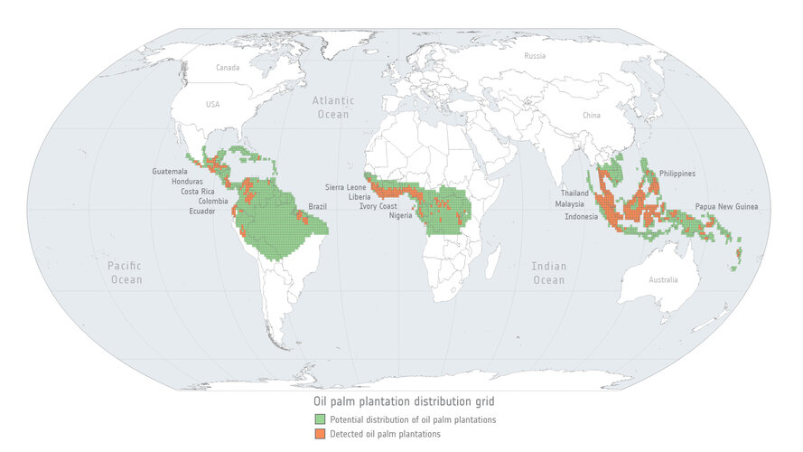
The global trade in agricultural commodities provides food, fuel and fibre to consumers around the world. Commodity production, however, is also linked with negative environmental impacts, including the loss and degradation of forested land.
Approximately 90% of global deforestation is driven by agricultural expansion – a phenomenon which has roots in the global demand for products such as palm oil, soy and beef. New research reveals how satellites can be used to map and monitor forest-cover changes and help implement effective zero deforestation commitments.
20220505_Odborný referent / vrchní referent oddělení právních vztahů
5.5.2022 10:51 ČÚZK - předpisy a opatření Katastrální úřad pro Středočeský kraj - Katastrální pracoviště Rakovník Vyhlášení výběrového řízení: Odborný referent / vrchní referent oddělení právních vztahů V části "Úřední deska", v sekci "Oznámení a jiná úřední sdělení" bylo vystaveno "Oznámení o vyhlášení výběrového řízení na obsazení služebního místa Odborný referent / vrchní referent oddělení právních vztahů"20220505_Odborný referent / vrchní referent oddělení právních vztahů
5.5.2022 10:51 ČÚZK /Urady/Katastralni-urady/Katastralni-urady/Katastralni-urad-pro-Stredocesky-kraj/Katastralni-pracoviste/KP-Rakovnik/O-uradu/Aktuality/20210922_Odborny-referent-oddeleni-aktualizace-(2)Odborný referent / vrchní referent oddělení právních vztahů
5.5.2022 10:50 ČÚZK - volná místa Katastrální úřad pro Středočeský kraj - Katastrální pracoviště Rakovník vypisuje výběrové řízení na místo Odborný referent / vrchní referent oddělení právních vztahůOdborný referent / vrchní referent oddělení právních vztahů
5.5.2022 10:50 ČÚZK - předpisy a opatření Katastrální úřad pro Středočeský kraj - Katastrální pracoviště Rakovníkvypisuje výběrové řízení na místo Odborný referent / vrchní referent oddělení právních vztahů
Odborný referent / vrchní referent oddělení právních vztahů
Odborný referent / vrchní referent oddělení právních vztahů
5.5.2022 10:50 ČÚZK /Urady/Katastralni-urady/Katastralni-urady/Katastralni-urad-pro-Stredocesky-kraj/Uredni-deska/Oznameni-a-jina-uredni-sdeleni/Volna-mista/Odborny-referent-vrchni-referent-oddeleni-pravnivýběrové řízení na TO KP Žďár nad Sázavou
5.5.2022 10:27 ČÚZK - předpisy a opatření Katastrální úřad pro Vysočinu - Katastrální pracoviště Žďár nad Sázavou zveřejnil novou aktualitu: Oznámení o vyhlášení výběrového řízení na služební místo odborný referent/vrchní referent v oddělení obnovy katastrální operátu II Technického odboru na Katastrálním úřadu pro Vysočinu, místo výkonu služby Žďár nad Sázavou.výběrové řízení na TO KP Žďár nad Sázavou
5.5.2022 10:27 ČÚZK /Urady/Katastralni-urady/Katastralni-urady/Katastralni-urad-pro-Vysocinu/O-uradu/Aktuality/vyberove-rizeni-na-TO-KP-Zdar-nad-SazavouKurz vysokohorské kartografie [Katedra aplikované geoinformatiky a kartografie, byTopic]
5.5.2022 10:15 Katedra aplikované geoinformatiky a kartografie Přf UK Zveme vás na kurz vysokohorské kartografie ve dnech 9. - 11. května. Přednášet a vést semináře bude rakouský horský vůdce a emeritní profesor kartografie na TU Dresden Manfred Buchroithner. Pořádá katedra aplikované geoinformatiky a kartografie s katedrou fyzické geografie a geoekologie.odborný_vrchní referent_OOKO II_Technický odbor
5.5.2022 9:57 ČÚZK /Urady/Katastralni-urady/Katastralni-urady/Katastralni-urad-pro-Vysocinu/Uredni-deska/Oznameni-a-jina-uredni-sdeleni/Volna-mista/DMS/odborny_vrchni-referent_OOKO-II_Technicky-odborodborný_vrchní referent_OOKO II_Technický odbor
5.5.2022 9:57 ČÚZK - předpisy a opatření Katastrální úřad pro Vysočinu technický odborvypisuje výběrové řízení na místo
odborný_vrchní referent_OOKO II_Technický odbor
odborný_vrchní referent_OOKO II_Technický odbor
5.5.2022 9:57 ČÚZK - volná místa Katastrální úřad pro Vysočinu technický odbor vypisuje výběrové řízení na místo odborný_vrchní referent_OOKO II_Technický odbor17. jednání KRS
5.5.2022 9:43 ČÚZK - předpisy a opatření Dne 18. května 2022 proběhne distančně sedmnácté jednání Koordinační rady správců DMVS a DTM.17. jednání KRS
5.5.2022 9:43 ČÚZK - předpisy a opatření Dne 18. května 2022 proběhne distančně sedmnácté jednání Koordinační rady správců DMVS a DTM.20220505_Rada / odborný rada v oddělení právních vztahů k nemovitostem
5.5.2022 6:59 ČÚZK /Urady/Katastralni-urady/Katastralni-urady/Katastralni-urad-pro-Stredocesky-kraj/Katastralni-pracoviste/KP-Rakovnik/O-uradu/Aktuality/20210922_Odborny-referent-oddeleni-aktualizace-(1)20220505_Rada / odborný rada v oddělení právních vztahů k nemovitostem
5.5.2022 6:59 ČÚZK - předpisy a opatření Katastrální úřad pro Středočeský kraj - Katastrální pracoviště Rakovník Vyhlášení výběrového řízení: Rada / odborný rada v oddělení právních vztahů k nemovitostem V části "Úřední deska", v sekci "Oznámení a jiná úřední sdělení" bylo vystaveno "Oznámení o vyhlášení výběrového řízení na obsazení služebního místa Rada / odborný rada v oddělení právních vztahů k nemovitostem"rada/odborný rada v oddělení právních vztahů k nemovitostem
5.5.2022 6:58 ČÚZK - předpisy a opatření Katastrální úřad pro Středočeský kraj - Katastrální pracoviště Rakovníkvypisuje výběrové řízení na místo rada/odborný rada v oddělení právních vztahů k nemovitostem
rada/odborný rada v oddělení právních vztahů k nemovitostem
rada/odborný rada v oddělení právních vztahů k nemovitostem
5.5.2022 6:58 ČÚZK - volná místa Katastrální úřad pro Středočeský kraj - Katastrální pracoviště Rakovník vypisuje výběrové řízení na místo rada/odborný rada v oddělení právních vztahů k nemovitostemrada/odborný rada v oddělení právních vztahů k nemovitostem
5.5.2022 6:58 ČÚZK /Urady/Katastralni-urady/Katastralni-urady/Katastralni-urad-pro-Stredocesky-kraj/Uredni-deska/Oznameni-a-jina-uredni-sdeleni/Volna-mista/rada-odborny-rada-v-oddeleni-pravnich-vztahu-k-(1)Juniper Systems Limited Releases New Geode GNS3 GNSS Receiver
4.5.2022 19:53 GISCafe.com Webcasts-Webinars BIRMINGHAM, United Kingdom, May 04, 2022 (GLOBE NEWSWIRE) -- Today Juniper Systems Limited, a manufacturer of rugged handheld computers and GNSS …Satellogic Announces Multiple Launch Agreement With SpaceX for Its Next 68 Sub-Meter Resolution Earth Observation Satellites
4.5.2022 19:53 GISCafe.com Webcasts-Webinars Strategic agreement positions Satellogic to achieve weekly remapping of the entire surface of the Earth in 2023 and over 20 daily revisits of any …Swift Navigation Joins STMicroelectronics Partner Program to Enhance the Accuracy of Automotive and IoT Applications
4.5.2022 19:53 GISCafe.com Webcasts-Webinars SAN FRANCISCO, May 04, 2022 (GLOBE NEWSWIRE) -- Swift Navigation, a San Francisco-based tech firm redefining GNSS (Global Navigation Satellite …GeoComm Partners With NextNav to Improve Emergency Response Indoors
4.5.2022 19:53 GISCafe.com Webcasts-Webinars MCLEAN, Va., May 04, 2022 (GLOBE NEWSWIRE) -- GeoComm, Public Safety Location Intelligence® Platform provider, is pleased to announce a new …UrbanFootprint Launches New Data Mapping and Analytics Solution to Drive Better Decision-Making in the Distribution of Government Aid
4.5.2022 19:53 GISCafe.com Webcasts-Webinars The new software solution, Government Assistance Program Intelligence, provides state and local government agencies, partners, and stakeholders with …CAD Symbols – 30 miliónů symbolů – nová verze
4.5.2022 17:40 ŠPINAR - software Vážení zákazníci,dovolujeme si Vám nabídnout program CAD Symbols v16 s ohromnou databází přes 30 milionů CAD symbolů ve 2D a 3D, které jednoduše vyhledáte a vložíte do svého CAD programu
CAD Symbols – 30 miliónů symbolů – nová verze
4.5.2022 17:40 ŠPINAR - softwareVážení zákazníci,
dovolujeme si Vám nabídnout program CAD Symbols v16 s ohromnou databází přes 30 milionů CAD symbolů ve 2D a 3D, které jednoduše vyhledáte a vložíte do svého CAD programu
The post CAD Symbols – 30 miliónů symbolů – nová verze appeared first on ŠPINAR – software.
Konference GIS Esri v ČR 2022 se uskuteční v Cubex Centru
4.5.2022 13:00 ARCDATAPo třech letech můžeme s radostí oznámit, že Konferenci GIS Esri v ČR 2022 plánujeme uspořádat opět prezenčně. Akce se uskuteční 1. a 2. listopadu a registrace bude oficiálně zahájena 30. května. Dojde ale ke změně místa konání – z pražského Kongresového centra se kvůli předsednictví ČR v Radě EU přesuneme do prostorů Cubex Centra. Registrace na akci je možná ve dvou úrovních – vybírat můžete mezi osobní účastí, nebo digitálním přístupem k veškerému konferenčnímu obsahu.
Program konference
Jako vždy pro vás připravujeme zajímavá vystoupení hlavních řečníků a sekce věnované veřejné správě, inženýrským sítím a novinkám v technologiích. Můžete se také těšit na workshopy a samozřejmě také na uživatelské přednášky nebo výstavu map a aplikací.
Uživatelské prezentace
Je pro nás důležité ukázat světu vaši práci. Pokud tedy máte nějaký zajímavý projekt, dejte nám o něm určitě vědět a my s ním budeme při přípravě programu počítat. Přihlásit nám takto můžete přednášku, mapové výstupy nebo svoji online aplikaci.
Aktuální informace o programu a organizaci letošní konference pro vás jsou dostupné na webové stránce akce.
Posouváme monitoring zase o krok dál!
4.5.2022 12:51 3gon Bezpečnost je na prvním místě a díky nové technologii máte možnost na dálku sledovat odlehlé oblasti bez nutnosti zajištění napájení, či čehokoli jiného!Omezení provozu pracoviště
4.5.2022 11:20 ČÚZK - předpisy a opatření Katastrální úřad pro Jihočeský kraj - Katastrální pracoviště Tábor zveřejnil novou aktualitu: Dne 13.5.2022 bude z důvodu přerušení dodávky elektrické energie provoz pracoviště výrazně omezen. Písemné podání, avšak bez možnosti platby správního poplatku, je možno v úředních hodinách v podatelně pracoviště učinit, vstup postranním vchodem z Mostecké ulice. Poskytování údajů z katastru či vyřízení jiných záležitostí se neprovádí.Omezení provozu pracoviště
4.5.2022 11:20 ČÚZK /Urady/Katastralni-urady/Katastralni-urady/Katastralni-urad-pro-Jihocesky-kraj/Katastralni-pracoviste/KP-Tabor/O-uradu/Aktuality/Omezeni-provozu-pracovisteOmezení provozu pracoviště
4.5.2022 11:20 ČÚZK - předpisy a opatření Katastrální úřad pro Jihočeský kraj - Katastrální pracoviště Táborzveřejnil novou aktualitu: Dne 13.5.2022 bude z důvodu přerušení dodávky elektrické energie provoz pracoviště výrazně omezen. Písemné podání, avšak bez možnosti platby správního poplatku, je možno v úředních hodinách v podatelně pracoviště učinit, vstup postranním vchodem z Mostecké ulice. Poskytování údajů z katastru či vyřízení jiných záležitostí se neprovádí.
Pozvánka na nové akce – obory stavebnictví a architektura, infrastruktura
4.5.2022 10:34 Arkance SystemsWebinář, konference o BIM a řada školení - zúčastněte se akcí Arkance Systems v květnu a červnu 2022.
Zpráva Pozvánka na nové akce – obory stavebnictví a architektura, infrastruktura pochází z arkance-systems.cz.
Pozvánka na nové akce – obory stavebnictví a architektura, infrastruktura
4.5.2022 10:34 Arkance SystemsWebinář, konference o BIM a řada školení - zúčastněte se akcí Arkance Systems v květnu a červnu 2022, přihlaste se včas
Zpráva Pozvánka na nové akce – obory stavebnictví a architektura, infrastruktura pochází z arkance-systems.cz.
20220504_Vrchní referent / rada oddělení dokumentace KN
4.5.2022 10:29 ČÚZK - předpisy a opatření Katastrální úřad pro Středočeský kraj - Katastrální pracoviště Praha-západ Vyhlášení výběrového řízení: Vrchní referent / rada oddělení dokumentace KN V části "Úřední deska", v sekci "Oznámení a jiná úřední sdělení" bylo vystaveno "Oznámení o vyhlášení výběrového řízení na obsazení služebního místa Vrchní referent / rada oddělení dokumentace KN"20220504_Vrchní referent / rada oddělení dokumentace KN
4.5.2022 10:29 ČÚZK /Urady/Katastralni-urady/Katastralni-urady/Katastralni-urad-pro-Stredocesky-kraj/Katastralni-pracoviste/KP-Praha-zapad/O-uradu/Aktuality/20210922_Odborny-referent-oddeleni-aktualizace-(4)Partnering to promote sustainable fisheries and aquafarms
4.5.2022 9:31 European GNSS Agency
A new Memorandum of Understanding aims to better leverage Galileo and Copernicus to further the goals of the Common Fisheries Policy and the EU’s Green Deal.
Today, the European Union Agency for the Space Programme (EUSPA) and the European Fisheries Control Agency (EFCA), the EU agency responsible for coordinating national operational activities in fisheries and assisting Member States in applying the Common Fisheries Policy (CFP), have signed a Memorandum of Understanding (MoU). The cooperation agreement reflects the two agencies shared commitment to creating sustainable fisheries and aquaculture – both of which are key components to the European Union’s Green Deal.
“Through the MoU, EUSPA will help EFCA better leverage the EU Space Programme, particularly Galileo, the European Global Satellite Navigation System (EGNSS) and Copernicus, the European Earth Observation programme. This agreement allows EFCA to gain new tools for enforcing the Common Fisheries Policy and EUSPA will also be able to benefit from EFCA’s expertise, allowing us to better meet the needs of the fisheries control community,” says EUSPA Executive Director Rodrigo da Costa.
Cracking down on illegal, unreported and unregulated fishing
Both Copernicus and Galileo are already being used to assess the location of fish stocks and to track the location of vessels in an effort to prevent illegal, unreported and unregulated (IUU) fishing, an important aspect of the CFP. The key to doing so is to increase transparency and provide precise information to policy makers and regulators like the EFCA. To this end, Earth Observation services, including the Maritime Surveillance component of the Copernicus Security Service, along with GNSS-based solutions utilising Automatic Identification Systems (AIS) and Vessel Monitoring Systems (VMS), are important tools in the fight against IUU fishing – a practice that not only costs the global economy between EUR 9 and 21 billion annually, but also threatens our oceans’ fragile biodiversity.
Galileo and Copernicus will improve EFCA capacity to detect, identify and categorise suspected non-compliant fishing activities and will result in safer, more sustainable and efficient maritime operations.
According to Dr Steele, EFCA is already using the EU Space Programme. Back in 2017, EFCA requested the support of Copernicus Maritime Surveillance (CMS) to monitor a vessel seen towing a cage of bluefin tuna – a strictly regulated species. By providing an optical image of a precise location, the agency was able to confirm that the targeted vessel was compliant with all relevant EU regulations.
Another good example of how Galileo and Copernicus are being used to curtail IUU fishing can be found in Norway, where the Norwegian Coastal Authority, in collaboration with Mercator Ocean, are combining GNSS and Earth Observation data with artificial intelligence to identify vessels with suspicious route patterns. The tool is contributing to a more efficient identification and monitoring of vessels that are possibly conducting illicit activities or are engaged in IUU fishing.
Supporting Europe’s growing aquaculture sector
Copernicus and Galileo are also being used to support Europe’s growing aquaculture sector. By providing information and data on environmental conditions (salinity, currents, temperature, etc.) and long-term weather forecasts, EO-based applications play a key role selecting ideal locations to establish aquafarms.
Once the aquafarm is up and running, much of the work is done by fully automated vessels that rely on the accurate positioning and navigation provided by Galileo.
Several projects set to benefit
To kick-off the MoU, EUSPA and EFCA have identified several EU-funded projects that could benefit from the agencies’ cooperation. These include Bluebox Porbeagle, which is developing a transceiver to report the position of vessels computed using Galileo and authenticated with Galileo Open Service Navigation Message Authentication, and GAMBAS, a project building a search and rescue beacon that can be remotely activated by rescue coordination centres. The MoU can be amended to expand the cooperation to include other projects and initiatives.
Media note: This feature can be republished without charge provided the European Union Agency for the Space Programme (EUSPA) is acknowledged as the source at the top or the bottom of the story. You must request permission before you use any of the photographs on the site. If you republish, we would be grateful if you could link back to the EUSPA website (http://www.euspa.europa.eu).
20220504 - doplnění Standardu RÚIAN
4.5.2022 8:18 ČÚZK /ruian/Novinky-RUIAN/Archiv-novinek-RUIAN/2022/20220504-doplneni-Standardu-RUIANOuster Bolsters Market Position, Reports Second-Highest Revenue Quarter
4.5.2022 3:54 GISCafe.com Webcasts-Webinars $8.6 million in revenue with 30% gross margins in Q1 2022Reiterates FY 2022 guidance
SAN FRANCISCO — (BUSINESS WIRE) — May 3, 2022 …
Skyway and Zing Operate First Drone Delivery in Orlando, Florida
4.5.2022 3:54 GISCafe.com Webcasts-Webinars ORLANDO, Fla., May 03, 2022 (GLOBE NEWSWIRE) -- Skyway and Zing Drone Delivery made Florida history with their latest partnership efforts. On …Živá mapa: topografie dějin přírodních věd v českých zemích [Knihovna geografie, byTopic]
4.5.2022 0:00 Katedra aplikované geoinformatiky a kartografie Přf UK Projekt Živá mapa, realizovaný na Přírodovědecké fakultě UK, rozvíjí myšlenku topografie dějin, tedy ukotvení prostorové dimenze do historie českých přírodních věd. V rámci tohoto projektu vznikla rozsáhlá, veřejně přístupná databáze a mapa obsahující záznamy o místech paměti české vědy. Záměrem bylo zachytit pamětní místa spojená s vědou na území Česka, která jsou připomínána a fixována ve veřejném prostoru jako pamětní desky, památníky, naučné stezky, expozice v muzeích, umělecká díla, budovy institucí apod.Advancing Water Wastewater and Stormwater Networks
3.5.2022 20:21 Bentley SystemsPressCoverage
Directions Magazine, USA
Read the articleNYSDOT Industrializes East 138th Street Bridge Using Digital Twin
3.5.2022 20:09 Bentley SystemsPress Coverage
Bentley Systems Strengthens Structural Tools with ADINA Acquisition
3.5.2022 20:03 Bentley SystemsPressCoverage
Engineering.com, USA
Read the articleVisualization Technology Helps Infrastructure Projects Come to Life
3.5.2022 19:59 Bentley SystemsPressCoverage
Cadalyst, USA
Read the articleThe metaverse in infrastructure
3.5.2022 19:55 Bentley SystemsPressCoverage
New Civil Engineer, UK&I
Read the articleSatellogic Announces Full Year 2021 Financial Results
3.5.2022 18:52 GISCafe.com Webcasts-Webinars Expanded its Fleet to 22 Satellites with Plans to Launch up to 12 Additional Satellites in 2022Closed Business Combination with CF Acquisition …
Garmin introduces ECHOMAP UHD2 chartplotter series with brand-new hardware and modern features
3.5.2022 18:52 GISCafe.com Webcasts-Webinars 5- and 7-inch keyed combo units deliver Garmin’s best-in-class sonar with built-in wireless networking and cartography contentOLATHE, Kan. — …
U.S. Annual Home Price Growth Exceeds 20% in March, CoreLogic Reports
3.5.2022 18:52 GISCafe.com Webcasts-Webinars March 2022 marked the 122nd straight month of year-over-year national home price increases with a 20.9% gainAnnual home price growth is projected …
Nocturne Drones Announces Cooperation with Dedrone and Expands Its Portfolio in Drone Defense Systems
3.5.2022 18:52 GISCafe.com Webcasts-Webinars Multi-award-winning drone show provider will use the leading solution for airspace security to protect events from unauthorized dronesMELLE, Germany …
AgEagle Reports Strong Government Demand for Blue UAS Approved eBee TAC™ UAS System
3.5.2022 18:52 GISCafe.com Webcasts-Webinars WICHITA, Kan., May 03, 2022 (GLOBE NEWSWIRE) -- AgEagle Aerial Systems Inc. (NYSE American: UAVS) (“AgEagle” or the “Company”), a …Draganfly’s First Medical Response Drone Now Deployed in Ukraine
3.5.2022 18:52 GISCafe.com Webcasts-Webinars Draganfly has successfully completed deployment and training of its first Medical Response Drone to Revived Soldiers Ukraine Los Angeles, CA., …Optelos Introduces Turnkey Drone Inspection Services Delivering Actionable Insights with 100% Satisfaction Guarantee
3.5.2022 18:52 GISCafe.com Webcasts-Webinars AUSTIN, Texas, May 3, 2022 — (PRNewswire) —Optelos' turnkey service specifically aligns data collection and analysis methodologies …
7 Geospatial Tech Developments to Watch in 2022
3.5.2022 18:11 Bentley SystemsPressCoverage
Roofers Coffee Shop, USA
Read the articleengineering and design
3.5.2022 18:08 Bentley SystemsPressCoverage
Progressive Railroading, USA
Read the articleScanning Roads for Yorks Roman Past
3.5.2022 18:05 Bentley SystemsPressCoverage
BIM+, UK&I
Read the articleFirst digital twin of a country
3.5.2022 18:01 Bentley SystemsPressCoverage
International Construction, UK&I
Read the articlePozvánka na seminář "Identifikace nových znečišťujících látek ve vodním prostředí a znečištění vod farmaky a mikropolutanty"
3.5.2022 17:47 Blogující geomatici - FAV ZČUDovolujeme si pozvat všechny zájemce na seminář ohledně Identifikace nových znečišťujících látek ve vodním prostředí a znečištění vod farmaky a mikropolutanty, který proběhne v pondělí 9. května 2022 od 13:30 do 15:30 v místnosti UN 656. Více v přiloženém info letáku.

Call for Media: Join ESA’s Living Planet Symposium in Bonn
3.5.2022 11:30 ESA Observing the Earth
Call for Media: Join ESA’s Living Planet Symposium in Bonn
EU Space Week 2022: Addressing user needs through #EUSpace
3.5.2022 10:55 European GNSS Agency
EU Space Week, the go-to event of for Europe’s space community, is happening 3 – 6 October 2022 in Prague, Czech Republic.
After two years of online-only editions, EU Space Week 2022 is set to bring together the entire European Union space community. From policymakers to industry, start-ups, public authorities, investors and users, EU Space Week is the place to be for anyone interested in current – and future – trends of the EU Space Programme.
The event is jointly organised by the European Commission and the EU Agency for the Space Programme (EUSPA) and held under the auspices of the Czech Presidency and the City of Prague.
What to expect
Plunge into the world of EU Space with several days full of exciting sessions, events, demonstrations and business opportunities.
With the aim of giving a ‘New Space’ angle to EU Space, this year’s edition will be about entrepreneurship and innovation in space-related businesses across the EU. We will also be showcasing the critical role the EU Space programme plays in igniting positive societal changes.
It's time to see each other again!
Let’s meet and reconnect in Prague at EU Space Week 2022!
Registration will be open soon, but you can already mark your calendars for 3 – 6 October.
And be sure to follow DG DEFIS (@DEFIS_eu) and EUSPA (@EU4Space) on Twitter for updates.
Media note: This feature can be republished without charge provided the European Union Agency for the Space Programme (EUSPA) is acknowledged as the source at the top or the bottom of the story. You must request permission before you use any of the photographs on the site. If you republish, we would be grateful if you could link back to the EUSPA website (http://www.euspa.europa.eu).
20220503_Vrchní referent / rada personálního oddělení Katastrálního úřadu
3.5.2022 9:51 ČÚZK /Urady/Katastralni-urady/Katastralni-urady/Katastralni-urad-pro-Stredocesky-kraj/O-uradu/Aktuality/20210922_Odborny-referent-oddeleni-aktualizace-(1)20220503_Vrchní referent / rada personálního oddělení Katastrálního úřadu
3.5.2022 9:51 ČÚZK - předpisy a opatření Katastrální úřad pro Středočeský kraj Vyhlášení výběrového řízení: Vrchní referent / rada personálního oddělení Katastrálního úřadu V části "Úřední deska", v sekci "Oznámení a jiná úřední sdělení" bylo vystaveno "Oznámení o vyhlášení výběrového řízení na obsazení služebního místa Vrchní referent / rada personálního oddělení Katastrálního úřadu"Vrchní referent / rada personálního oddělení Katastrálního úřadu
3.5.2022 9:49 ČÚZK /Urady/Katastralni-urady/Katastralni-urady/Katastralni-urad-pro-Stredocesky-kraj/Uredni-deska/Oznameni-a-jina-uredni-sdeleni/Volna-mista/Vrchni-referent-rada-personalniho-oddeleni-KatasVrchní referent / rada personálního oddělení Katastrálního úřadu
3.5.2022 9:49 ČÚZK - předpisy a opatření Katastrální úřad pro Středočeský krajvypisuje výběrové řízení na místo Vrchní referent / rada personálního oddělení Katastrálního úřadu
Vrchní referent / rada personálního oddělení Katastrálního úřadu
Vrchní referent / rada personálního oddělení Katastrálního úřadu
3.5.2022 9:49 ČÚZK - volná místa Katastrální úřad pro Středočeský kraj vypisuje výběrové řízení na místo Vrchní referent / rada personálního oddělení Katastrálního úřaduAPGEO - Pozvánka na 9. setkání geodetů Jihočeského kraje
3.5.2022 2:00 Asociace podnikatelů v geomatice Srdečně vás zveme na 9. setkání geodetů Jihočeského kraje, které se uskuteční 24. 5. v Českých Budějovicích.Fusion 360 v akci se stroji HAAS – živé měření
3.5.2022 0:17 Arkance SystemsInovativní ověření zadaných rozměrů a tolerancí konstrukčních dílů přímo na stroji díky propojení HAAS → Fusion 360.
Zpráva Fusion 360 v akci se stroji HAAS – živé měření pochází z arkance-systems.cz.
Fusion 360 v akci se stroji HAAS – živé měření
3.5.2022 0:17 Arkance SystemsInovativní, OMV (On Machine Verification) měření zadaných rozměrů a tolerancí konstrukčních dílů přímo na stroji díky propojení HAAS → Fusion 360.
Zpráva Fusion 360 v akci se stroji HAAS – živé měření pochází z arkance-systems.cz.
Nabídka práce - projektový manažer
3.5.2022 0:00 Geografický ústav MUSpolečnost RPA hledá do svého týmu studenty sociální geografie na pozici projektového manažera.
Bližší informace naleznete zde.
Autodesk Extends Invitation to Join Financial Results Conference Call
2.5.2022 19:27 GISCafe.com Webcasts-Webinars SAN FRANCISCO, May 2, 2022 — (PRNewswire) — Autodesk, Inc. (NASDAQ: ADSK) today announced it will broadcast its first quarter fiscal …Woolpert Hires Florida Geospatial Leader Rick Householder to Augment Statewide Mapping
2.5.2022 19:26 GISCafe.com Webcasts-Webinars MIAMI, May 2, 2022 — (PRNewswire) —A longtime trailblazer at the South Florida Water Management District, Householder will support …
Innoviz Selected by One of the Largest Global Vehicle Groups to be its Direct LiDAR Supplier for Series Production Vehicles; Increases Forward-Looking Order Book by $4 Billion
2.5.2022 19:26 GISCafe.com Webcasts-Webinars TEL AVIV, Israel, May 2, 2022 — (PRNewswire) — Innoviz Technologies Ltd. (NASDAQ: INVZ) (the "Company" or "Innoviz"), a leading …How digital twins connect finance and sustainability
2.5.2022 16:49 Bentley SystemsPressCoverage
Venture Beat, USA
Read the articleHow Do You Design and Build a Manufacturing Facility
2.5.2022 16:45 Bentley SystemsPressCoverage
Engineering.com, USA
Read the article