


![]()

zprávy
zdroje zpráv:Výběrové řízení
15.3.2022 8:47 ČÚZK - předpisy a opatření Katastrální úřad pro Liberecký kraj zveřejnil novou aktualitu: Oznámení o vyhlášení výběrového řízení na služební místo rada / odborný rada v oddělení aktualizace a dokumentace KN na KP Jablonec nad NisouVýběrové řizení
15.3.2022 8:43 ČÚZK - předpisy a opatření Katastrální úřad pro Liberecký kraj zveřejnil novou aktualitu: Oznámení o vyhlášení výběrového řízení na služební místo odborný referent v oddělení aktualizace a dokumentace KN na KP Jablonec nad NisouVýběrové řizení
15.3.2022 8:43 ČÚZK /Urady/Katastralni-urady/Katastralni-urady/Katastralni-urad-pro-Liberecky-kraj/O-uradu/Aktuality/Vyberove-rizeniGaKO 3/2022
15.3.2022 8:25 GaKO GaKO 3/2022 LEITMANNOVÁ, K.–GÁLOVÁ, L.–LIESKOVSKÝ, T.–BISTÁK, P.–ZACHAR, J.: Projekt leteckého laserového skenovania Slovenskej republiky a jeho využitie v manažmente ochrany archeologického dedičstvaCircle Optics Awarded $1,750,000 To Revolutionize Situational Awareness Through Enhanced Imaging
14.3.2022 21:33 GISCafe.com Webcasts-Webinars ROCHESTER, N.Y., March 14, 2022 (GLOBE NEWSWIRE) -- Circle Optics, innovators with patented technology enabling real-time, high-resolution …POWER division name change reflects growing utility focus
14.3.2022 17:52 GISCafe.com Webcasts-Webinars BOISE, Idaho (Mar. 9, 2022) -- POWER Engineers, Incorporated (POWER) is strengthening its emphasis on meeting the demands for location-based …Astraea and Satellogic Launch Ukraine Observer
14.3.2022 17:13 GISCafe.com Webcasts-Webinars CHARLOTTESVILLE, Va., March 14, 2022 (GLOBE NEWSWIRE) -- Astraea, developer of the EarthAI geospatial analytics platform, announced a collaboration …Hexagon US Federal Brings ARTEMIS Solution to Federal Government Defense and Public Safety Professionals
14.3.2022 17:13 GISCafe.com Webcasts-Webinars CHANTILLY, Va., March 14, 2022 — (PRNewswire) — Hexagon US Federal is pleased to share that through its partnership with senseFly …
Odstávka Portálu ESKN
14.3.2022 16:25
ÚGKK SR
Dnes - 14.03.2022 - bude v čase od 21:00 do 22:00 hod. mimoriadna odstávka Portálu ESKN /servisný zásah/. Z uvedeného dôvodu nebudú v uvedenom čase dostupné elektronické služby katastra nehnuteľností pre verejnosť.
Odborný rada - vedoucí oddělení metodiky, kontroly a personalistiky
14.3.2022 14:15 ČÚZK - předpisy a opatření Katastrální úřad pro Královéhradecký kraj kancelář ředitelevypisuje výběrové řízení na místo
Odborný rada - vedoucí oddělení metodiky, kontroly a personalistiky
Odborný rada - vedoucí oddělení metodiky, kontroly a personalistiky
14.3.2022 14:15 ČÚZK - volná místa Katastrální úřad pro Královéhradecký kraj kancelář ředitele vypisuje výběrové řízení na místo Odborný rada - vedoucí oddělení metodiky, kontroly a personalistikyOdborný rada - vedoucí oddělení metodiky, kontroly a personalistiky
14.3.2022 14:15 ČÚZK /Urady/Katastralni-urady/Katastralni-urady/Katastralni-urad-pro-Kralovehradecky-kraj/Volna-mista/DMS/Odborny-rada-vedouci-oddeleni-metodiky,-kontrolyvrchní referent/rada - obnova katastrálního operátu v oddělení obnovy a revize KN Katastrálního prac
14.3.2022 13:53 ČÚZK - předpisy a opatření Katastrální úřad pro Jihočeský kraj Katastrální pracoviště České Budějovicevypisuje výběrové řízení na místo
vrchní referent/rada - obnova katastrálního operátu v oddělení obnovy a revize KN Katastrálního pracoviště České Budějovice
vrchní referent/rada - obnova katastrálního operátu v oddělení obnovy a revize KN Katastrálního prac
14.3.2022 13:53 ČÚZK - volná místa Katastrální úřad pro Jihočeský kraj Katastrální pracoviště České Budějovice vypisuje výběrové řízení na místo vrchní referent/rada - obnova katastrálního operátu v oddělení obnovy a revize KN Katastrálního pracvrchní referent/rada - obnova katastrálního operátu v oddělení obnovy a revize KN Katastrálního prac
14.3.2022 13:53 ČÚZK /Urady/Katastralni-urady/Katastralni-urady/Katastralni-urad-pro-Jihocesky-kraj/Uredni-deska/Oznameni-a-jina-uredni-sdeleni/Volna-mista/DMS/vrchni-referent-rada-obnova-katastralniho-oper-(1)VR do 4.4. rada/odborný rada – právník
14.3.2022 13:51 ČÚZK - předpisy a opatření Katastrální úřad pro hlavní město Prahu - Katastrální pracoviště Praha zveřejnil novou aktualitu: Ředitelka úřadu vyhlašuje výběrové řízení na samostatné systemizované služební místo:rada/odborný rada – právník
VR do 4.4. rada/odborný rada – právník
14.3.2022 13:51 ČÚZK /Urady/Katastralni-urady/Katastralni-urady/Katastralni-urad-pro-hlavni-mesto-Prahu/O-uradu/Aktuality/VR-do-4-4-rada-odborny-rada-–-pravnikVR do 4.4. rada/odborný rada – právník
14.3.2022 13:51 ČÚZK - předpisy a opatření Český úřad zeměměřický a katastrální - Katastrální pracoviště Praha zveřejnil novou aktualitu: Ředitelka úřadu vyhlašuje výběrové řízení na samostatné systemizované služební místo:rada/odborný rada – právník
místo odborný referent – vedení katastrální mapy, v oddělení aktualizace a dokumentace KN
14.3.2022 13:32 ČÚZK /Urady/Katastralni-urady/Katastralni-urady/Katastralni-urad-pro-Liberecky-kraj/Uredni-deska/Oznameni-a-jina-uredni-sdeleni/Volna-mista/misto-odborny-referent-–-vedeni-katastralni-mapymísto odborný referent – vedení katastrální mapy, v oddělení aktualizace a dokumentace KN
14.3.2022 13:32 ČÚZK - volná místa Katastrální úřad pro Liberecký kraj - Katastrální pracoviště Jablonec nad Nisou vypisuje výběrové řízení na místo místo odborný referent – vedení katastrální mapy, v oddělení aktualizace a dokumentace KNmísto odborný referent – vedení katastrální mapy, v oddělení aktualizace a dokumentace KN
14.3.2022 13:32 ČÚZK - předpisy a opatření Katastrální úřad pro Liberecký kraj - Katastrální pracoviště Jablonec nad Nisouvypisuje výběrové řízení na místo
místo odborný referent – vedení katastrální mapy, v oddělení aktualizace a dokumentace KN
ESA probing navigation via the quantum realm
14.3.2022 13:31 ESA Navigation
ESA’s NAVISP programme – helping to invent the future of European navigation – is probing the science of the very small. The aim is to employ hyper-sensitive quantum technology-based sensors as supplementary navigation solutions, including tracking local variations in gravity that could be matched onto regional and global gravity maps.
místo rada / odborný rada – obnova katastrálního operátu, v oddělení aktualizace a dokumentace KN
14.3.2022 13:21 ČÚZK - volná místa Katastrální úřad pro Liberecký kraj - Katastrální pracoviště Jablonec nad Nisou vypisuje výběrové řízení na místo místo rada / odborný rada – obnova katastrálního operátu, v oddělení aktualizace a dokumentace KNmísto rada / odborný rada – obnova katastrálního operátu, v oddělení aktualizace a dokumentace KN
14.3.2022 13:21 ČÚZK - předpisy a opatření Katastrální úřad pro Liberecký kraj - Katastrální pracoviště Jablonec nad Nisouvypisuje výběrové řízení na místo
místo rada / odborný rada – obnova katastrálního operátu, v oddělení aktualizace a dokumentace KN
místo rada / odborný rada – obnova katastrálního operátu, v oddělení aktualizace a dokumentace KN
14.3.2022 13:21 ČÚZK /Urady/Katastralni-urady/Katastralni-urady/Katastralni-urad-pro-Liberecky-kraj/Uredni-deska/Oznameni-a-jina-uredni-sdeleni/Volna-mista/misto-rada-odborny-rada-–-obnova-katastralnihoVýsledky evropského monitoringu LIFO
14.3.2022 12:15 ČÚZK - aktuality v resortu Zveřejněny výsledky evropského monitoringu LIFO - "Location Interoperability Framework Observatory" za období 2020-2021, které za Českou republiku vytváří ČÚZK. ČR se umístila na 1. místě mezi 23 sledovanými zeměmi.Výsledky evropského monitoringu LIFO
14.3.2022 12:15 ČÚZK - předpisy a opatření Český úřad zeměměřický a katastrální zveřejnil novou aktualitu: Zveřejněny výsledky evropského monitoringu LIFO - "Location Interoperability Framework Observatory" za období 2020-2021, které za Českou republiku vytváří ČÚZK. ČR se umístila na 1. místě mezi 23 sledovanými zeměmi.Výsledky evropského monitoringu LIFO
14.3.2022 12:15 ČÚZK /Aktuality-resort/2022/Vysledky-evropskeho-monitoringu-LIFOPlánovaná odstávka ISÚI
14.3.2022 8:16 ČÚZK /ruian/Editacni-agendovy-system-ISUI/Provozni-informace-a-odstavky/Archiv-PROD/Planovana-odstavka-ISUIAktualizovaná data ortofota ČR
14.3.2022 7:01 ČÚZK - Geoportál Aktualizovaná data ortofota ČRV rozsahu 1/2 ČR - západní poloviny území - byl aktualizován produkt Ortofoto ČR.
Data byla zpracována z leteckého snímkování v roce 2021. Pixel rastrového obrazu Ortofota ČR zobrazuje nyní v tomto pásmu Západ 0,125 m (oproti 0,200 m u ortofota z roku 2020 v pásmu Východ).
Přesné datum pořízení snímků pro jednotlivé mapové listy a přesný rozsah aktualizovaného území viz Stav aktualizace.
Nové soubory ortofota ve formátu JPEG již lze objednávat v e-shopu.
Prohlížecí služby Ortofoto WMS, WMTS a ArcGIS Server jsou již také aktualizovány a jsou dostupné například v aplikacích Geoprohlížeč, Nahlížení do KN, nebo Analýzy výškopisu.
Aktualizovaná data ortofota ČR
14.3.2022 6:01 ČÚZK - Geoportál Aktualizovaná data ortofota ČRV rozsahu 1/2 ČR - západní poloviny území - byl aktualizován produkt Ortofoto ČR.
Data byla zpracována z leteckého snímkování v roce 2021. Pixel rastrového obrazu Ortofota ČR zobrazuje nyní v tomto pásmu Západ 0,125 m (oproti 0,200 m u ortofota z roku 2020 v pásmu Východ).
Přesné datum pořízení snímků pro jednotlivé mapové listy a přesný rozsah aktualizovaného území viz Stav aktualizace.
Nové soubory ortofota ve formátu JPEG již lze objednávat v e-shopu.
Prohlížecí služby Ortofoto WMS, WMTS a ArcGIS Server jsou již také aktualizovány a jsou dostupné například v aplikacích Geoprohlížeč, Nahlížení do KN, nebo Analýzy výškopisu.
Nabídka Ph.D. pozice - dendroekologie
13.3.2022 0:00 Geografický ústav MUKatedra fyzické geografie a geoekologie PřF UK otevírá Ph.D. pozici zaměřenou na dendroekologii.
Bližší informace nalezneze zde.
Práca v ESPRIT: Špecialista na hydrologické a hydrodynamické modelovanie
12.3.2022 10:19 Geocommunity.skPríspevok Práca v ESPRIT: Špecialista na hydrologické a hydrodynamické modelovanie zobrazený najskôr GeoCommunity.sk.
Práca ESPRIT: Špecialista na hydrologické a hydrodynamické modelovanie
12.3.2022 10:19 Geocommunity.skPríspevok Práca ESPRIT: Špecialista na hydrologické a hydrodynamické modelovanie zobrazený najskôr GeoCommunity.eu.
Práca ESPRIT: Špecialista na hydrologické a hydrodynamické modelovanie
12.3.2022 10:19 Geocommunity.skPríspevok Práca ESPRIT: Špecialista na hydrologické a hydrodynamické modelovanie zobrazený najskôr GeoCommunity.sk.
Dawood Engineering Receives Esri's Web GIS Transformation Award at Esri Partner Conference for Geo-Enabling a Land Management Workflow
12.3.2022 3:03 GISCafe.com Webcasts-Webinars Dawood Engineering's award-winning Land Management GIS Portal geo-enables spreadsheet workflows as part of a multi-phased Southern Company Gas …Terracon Receives 2021 EBJ Business Achievement Awards
12.3.2022 3:03 GISCafe.com Webcasts-Webinars SAN DIEGO, March 11, 2022 — (PRNewswire) — Environmental Business Journal®* (EBJ), a business research publication which provides …Maxar’s satellites Satellite Images: 10 March 2022, Activity in and around Kyiv, Chernihiv and Chernobyl, Ukraine
11.3.2022 23:33 GISCafe.com Webcasts-Webinars Maxar’s satellites collected an extensive amount of imagery over the past 24 hours (more than 15,000 square kilometers collected today) over …Maxar Satellite Images: Mariupol, Ukraine 9 March 2022
11.3.2022 22:47 GISCafe.com Webcasts-Webinars Maxar collected new satellite imagery yesterday morning (March 9, 2022) of the besieged southern Ukrainian city of Mariupol. The imagery was …Trimble Dimensions+ Showcase your success—answer our Call for Speakers
11.3.2022 22:15 GISCafe.com Webcasts-Webinars Calling all industry experts! There are four weeks left to submit your proposal to speak at Dimensions+ and showcase your success using Trimble …Satellite Imagery: Kyiv 8 March 2022
11.3.2022 21:52 GISCafe.com Webcasts-Webinars Although poor weather and heavy cloud-cover continues to obscure our view over much of Ukraine yesterday (March 8, 2022) and over the past week, …Přerušení provozu WSGP v pátek 18.3.2022 od 17:00 až do neděle 20.3.2022 do cca 12:00.
11.3.2022 19:35 ČÚZK - předpisy a opatření Vážení uživatelé,oznamujeme, že v pátek 18.3.2022 od 17:00 bude z technických důvodů zcela přerušen provoz Webových služeb pro geodety. Obnovení provozu předpokládáme 20.3.2022 v cca 12 hodin. V rámci odstávky nedochází ke změnám webových služeb.
Za komplikace tímto způsobené se omlouváme a děkujeme za pochopení.
Přerušení provozu WSGP v pátek 18.3.2022 od 17:00 až do neděle 20.3.2022 do cca 12:00.
11.3.2022 19:35 ČÚZK /Aplikace-DP-do-KN/Aplikace-DP-do-KN/Archiv-DP/349958Přerušení provozu WSGP v pátek 18.3.2022 od 17:00 až do neděle 20.3.2022 do cca 12:00.
11.3.2022 19:35 Dálkový přístup k údajům KN ČR Vážení uživatelé,oznamujeme, že v pátek 18.3.2022 od 17:00 bude z technických důvodů zcela přerušen provoz Webových služeb pro geodety. Obnovení provozu předpokládáme 20.3.2022 v cca 12 hodin. V rámci odstávky nedochází ke změnám webových služeb.
Za komplikace tímto způsobené se omlouváme a děkujeme za pochopení.
Going Digital for Infrastructure Resilience
11.3.2022 15:09 Bentley SystemsPressCoverage
Geospatial World, India
Read the articleTermíny státních závěrečných zkoušek [Katedra aplikované geoinformatiky a kartografie, byTopic]
11.3.2022 14:00 Katedra aplikované geoinformatiky a kartografie Přf UK Termíny pro bakalářské a magisterské obory - jaro a podzim 2021/2022.Termíny státních závěrečných zkoušek [Katedra aplikované geoinformatiky a kartografie, byTopic]
11.3.2022 14:00 Katedra aplikované geoinformatiky a kartografie Přf UK Termíny pro bakalářské a magisterské obory - jaro a podzim 2022.43 innovative space-based solutions shortlisted in the #myEUspace competition
11.3.2022 13:03 European GNSS Agency
With over EUR 1 million in prize money on the line, #myEUspace is one of the biggest competitions ever organised by EUSPA.
The #myEUspace competition supports the development of innovative commercial applications that leverage data coming from the EU Space Programme. To get there, it’s put over EUR 1 million in prize money on the table, and the best of the opportunities to create successful start-ups on the European market.
Targets and tracks
Applicants could choose to compete in one of two tracks, depending on the maturity of their solution. Track 1 focused on taking an idea to prototype or beta version, whilst Track 2 was for advancing prototypes/beta versions towards commercial readiness. The #myEUspace competition called for ideas on a number of thematic topics to support innovation on Europe. The 6 targeted areas of innovation included:
• smart mobility solutions
• consumer solutions for health, gaming, sports, leisure, tourism and everyday life.
• solutions addressing environmental challenges,
• surveying solutions to shape the future of geomatics
• solutions that manage the variability of agricultural production
• and finally, innovative solutions applying quantum technologies
Now, after receiving more than 200 applications the results are finally in. 43 projects have been selected for their potential to bring disruptive, space-based solutions onto the European market.
The shortlisted teams are working on a range of novel solutions, new technologies, mobile apps and hardware. While the solutions cover such diverse sectors as location-based services, smart mobility, geomatics and smart agriculture, they all share a foundation in their use of Galileo or Copernicus data as well as their synergies between the two space programme components.
“Space data is at the heart of the technological revolution currently sweeping Europe, and this competition is another example of how EUSPA supports innovative entrepreneurs, start-ups and SMEs from across the EU who are leveraging Copernicus and Galileo data, information and services,” says Rodrigo da Costa, Executive Director, European Union Agency for the Space Programme (EUSPA).
Click here to see the 43 semi-finalists
On to the development phase
The 23 teams selected from Track 1 each received EUR 10,000, while the 20 Track 2 teams were awarded EUR 15,000. All teams will use the funding to continue developing their prototype or product. The 43 projects now advance into the development phase of the competition, where they will fine-tune their prototypes and products and refine their business plans. This intense nine-week phase culminates at the #myEUspace contest finals on 1 June.
During the finals, each team will have the opportunity to pitch and demonstrate their solution to invited guests. The winners of each innovation area will win an additional prize of EUR 25,000 and EUR 50,000 in Track 1 and Track 2 respectively.
#myEUspace is organised by EUSPA as part of the European Commission’s CASSINI - Space Entrepreneurship Initiative.
Good luck to all the #myEUspace finalists!
Media note: This feature can be republished without charge provided the European Union Agency for the Space Programme (EUSPA) is acknowledged as the source at the top or the bottom of the story. You must request permission before you use any of the photographs on the site. If you republish, we would be grateful if you could link back to the EUSPA website (http://www.euspa.europa.eu).
Odborný referent v oddělení právních vztahů Katastrálního pracoviště Trutnov - 7.pl.tř.
11.3.2022 12:52 ČÚZK - volná místa Katastrální úřad pro Královéhradecký kraj Katastrální pracoviště Trutnov vypisuje výběrové řízení na místo Odborný referent v oddělení právních vztahů Katastrálního pracoviště Trutnov - 7.pl.tř.Odborný referent v oddělení právních vztahů Katastrálního pracoviště Trutnov - 7.pl.tř.
11.3.2022 12:52 ČÚZK /Urady/Katastralni-urady/Katastralni-urady/Katastralni-urad-pro-Kralovehradecky-kraj/Uredni-deska/Oznameni-a-jina-uredni-sdeleni/Volna-mista/DMS/Odborny-referent-v-oddeleni-pravnich-vztahu-Ka-(1)Odborný referent v oddělení právních vztahů Katastrálního pracoviště Trutnov - 7.pl.tř.
11.3.2022 12:52 ČÚZK - předpisy a opatření Katastrální úřad pro Královéhradecký kraj Katastrální pracoviště Trutnovvypisuje výběrové řízení na místo
Odborný referent v oddělení právních vztahů Katastrálního pracoviště Trutnov - 7.pl.tř.
Odborný referent v oddělení právních vztahů Katastrálního pracoviště Trutnov
11.3.2022 12:49 ČÚZK - předpisy a opatření Katastrální úřad pro Královéhradecký kraj Katastrální pracoviště Trutnovvypisuje výběrové řízení na místo
Odborný referent v oddělení právních vztahů Katastrálního pracoviště Trutnov - 8.pl.tř.
Odborný referent v oddělení právních vztahů Katastrálního pracoviště Trutnov
11.3.2022 12:49 ČÚZK /Urady/Katastralni-urady/Katastralni-urady/Katastralni-urad-pro-Kralovehradecky-kraj/Uredni-deska/Oznameni-a-jina-uredni-sdeleni/Volna-mista/DMS/Odborny-referent-v-oddeleni-pravnich-vztahu-KatastOdborný referent v oddělení právních vztahů Katastrálního pracoviště Trutnov
11.3.2022 12:49 ČÚZK - volná místa Katastrální úřad pro Královéhradecký kraj Katastrální pracoviště Trutnov vypisuje výběrové řízení na místo Odborný referent v oddělení právních vztahů Katastrálního pracoviště TrutnovEarth from Space: Lofoten, Norway
11.3.2022 10:00 ESA Observing the Earth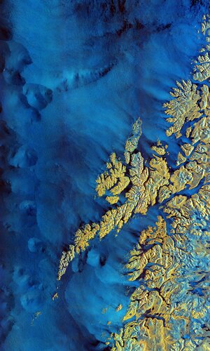
The Copernicus Sentinel-1 mission takes us over the archipelago of Lofoten in northern Norway.
Announcement from buildingSMART International and the Board
11.3.2022 9:32 buildingSMART.orgLondon, U.K. - March 11, 2022 - buildingSMART International is shocked and saddened by the crisis unfolding in Ukraine. buildingSMART condemns the invasion by Russia and our thoughts are very much with the people of Ukraine at this awful time. As an international body that seeks cooperation and collaboration at its core, we hope for a peaceful…
The post Announcement from buildingSMART International and the Board appeared first on buildingSMART International.
Register for ESA’s Living Planet Symposium in Bonn
11.3.2022 9:10 ESA Observing the Earth
The time has come to register to attend the European Space Agency’s Living Planet Symposium – one of the largest Earth observation conferences in the world. Taking place on 23–27 May 2022 in Bonn, Germany, and jointly organised with the German Aerospace Center, this prestigious event allows all attendees to hear first-hand about the latest scientific findings on our planet. Attendees will also hear how observing Earth from space supports environmental research and action to combat the climate crisis, learn about novel Earth observing technologies and, importantly, learn about the new opportunities emerging in the rapidly changing sector of Earth observation.
BlackSky to Participate at Upcoming Investor Conferences
11.3.2022 9:00 GISCafe.com Webcasts-Webinars HERNDON, Va. — (BUSINESS WIRE) — March 9, 2022 — BlackSky Technology Inc. (“BlackSky” or the “Company”) …Cepton Inc. Announces Date for Business Update and Full Year 2021 Results
11.3.2022 9:00 GISCafe.com Webcasts-Webinars SAN JOSE, Calif. — (BUSINESS WIRE) — March 7, 2022 — Cepton, Inc. (“Cepton”) (Nasdaq: CPTN), a Silicon Valley innovator …Maxar Technologies to Participate in Upcoming Investor Conference
11.3.2022 9:00 GISCafe.com Webcasts-Webinars WESTMINSTER, Colo. — (BUSINESS WIRE) — March 9, 2022 — Maxar Technologies (NYSE:MAXR) (TSX:MAXR), provider of comprehensive space …Planet to Announce Fiscal Fourth Quarter and Full Year 2022 Results on Thursday, March 31, 2022
11.3.2022 9:00 GISCafe.com Webcasts-Webinars SAN FRANCISCO — (BUSINESS WIRE) — March 8, 2022 — Planet Labs PBC (NYSE:PL), a leading provider of daily data and insights about …20220311 – Přechod na kódování UTF-8 v souborech VFK
11.3.2022 8:30 ČÚZK - Výměnný formát ISKN Vážení zákazníci, upozorňujeme, že již v polovině dubna dojde k avizovanému přechodu databáze ISKN na kódování UTF-8 a s tím k úpravě exportu a importu VFK. Nově bude umožněno pouze kódování UTF-8. Dosud používaná kódování již nebudou nadále podporována. V rámci instalace nové verze ISKN 9.3 bude zachována stávající struktura výměnného formátu ISKN a realizován bude pouze přechod na kódování UTF-8. Soubory VFK ponesou nově označení 6.0. Předpokládaný termín instalace je 14.4.2022.20220311 – Přechod na kódování UTF-8 v souborech VFK
11.3.2022 8:30 ČÚZK - Výměnný formát ISKN Vážení zákazníci, upozorňujeme, že již v polovině dubna dojde k avizovanému přechodu databáze ISKN na kódování UTF-8 a s tím k úpravě exportu a importu VFK. Nově bude umožněno pouze kódování UTF-8. Dosud používaná kódování již nebudou nadále podporována. V rámci instalace nové verze ISKN 9.3 bude zachována stávající struktura výměnného formátu ISKN a realizován bude pouze přechod na kódování UTF-8. Soubory VFK ponesou nově označení 6.0. Předpokládaný termín instalace je 14.4.2022.20220311 – Přechod na kódování UTF-8 v souborech VFK
11.3.2022 8:30 ČÚZK - Výměnný formát ISKN Vážení zákazníci, upozorňujeme, že již v polovině dubna dojde k avizovanému přechodu databáze ISKN na kódování UTF-8 a s tím k úpravě exportu a importu VFK. Nově bude umožněno pouze kódování UTF-8. Dosud používaná kódování již nebudou nadále podporována. V rámci instalace nové verze ISKN 9.3 bude zachována stávající struktura výměnného formátu ISKN a realizován bude pouze přechod na kódování UTF-8. Soubory VFK ponesou nově označení 6.0. Předpokládaný termín instalace je 14.4.2022.20220311 – Přechod na kódování UTF-8 v souborech VFK
11.3.2022 8:30 ČÚZK - Výměnný formát ISKN Vážení zákazníci, upozorňujeme, že již v polovině dubna dojde k avizovanému přechodu databáze ISKN na kódování UTF-8 a s tím k úpravě exportu a importu VFK. Nově bude umožněno pouze kódování UTF-8. Dosud používaná kódování již nebudou nadále podporována. V rámci instalace nové verze ISKN 9.3 bude zachována stávající struktura výměnného formátu ISKN a realizován bude pouze přechod na kódování UTF-8. Soubory VFK ponesou nově označení 6.0. Předpokládaný termín instalace je 14.4.2022.20220311 – Přechod na kódování UTF-8 v souborech VFK
11.3.2022 8:30 ČÚZK - předpisy a opatření Vážení zákazníci, upozorňujeme, že již v polovině dubna dojde k avizovanému přechodu databáze ISKN na kódování UTF-8 a s tím k úpravě exportu a importu VFK. Nově bude umožněno pouze kódování UTF-8. Dosud používaná kódování již nebudou nadále podporována. V rámci instalace nové verze ISKN 9.3 bude zachována stávající struktura výměnného formátu ISKN a realizován bude pouze přechod na kódování UTF-8. Soubory VFK ponesou nově označení 6.0. Předpokládaný termín instalace je 14.4.2022.20220311 – Přechod na kódování UTF-8 v souborech VFK
11.3.2022 8:30 ČÚZK - Výměnný formát ISKN Vážení zákazníci, upozorňujeme, že již v polovině dubna dojde k avizovanému přechodu databáze ISKN na kódování UTF-8 a s tím k úpravě exportu a importu VFK. Nově bude umožněno pouze kódování UTF-8. Dosud používaná kódování již nebudou nadále podporována. V rámci instalace nové verze ISKN 9.3 bude zachována stávající struktura výměnného formátu ISKN a realizován bude pouze přechod na kódování UTF-8. Soubory VFK ponesou nově označení 6.0. Předpokládaný termín instalace je 14.4.2022.Cepton, Inc. Reports Fourth Quarter and Full Year 2021 Results and Provides 2022 Business Updates and Milestones
11.3.2022 0:45 GISCafe.com Webcasts-Webinars Successful public listing in February 2022, resulting in cash and available liquidity of $175 millionCompleted key production milestones with …
AUVSI Commends Safety Focused UAS Beyond Visual Line of Sight Aviation Rulemaking Committee Report
11.3.2022 0:45 GISCafe.com Webcasts-Webinars Arlington, Va., March 10, 2022 (GLOBE NEWSWIRE) -- Today, the Association for Uncrewed Vehicle Systems International (AUVSI), applauded the …RNDr. Ivan Kupčík odešel... [Knihovna geografie, byTopic]
11.3.2022 0:00 Katedra aplikované geoinformatiky a kartografie Přf UK Po nedávném odchodu dr. Tomáše Grima nás zastihla další smutná zpráva - ve věku nedožitých 79 let zemřel RNDr. Ivan Kupčík, historický kartograf se zaměřením na dějiny kartografie českých zemí a středoevropské oblasti, mj. též bývalý kurátor Mapové sbírky. Čest jeho památce!Gresham Smith Revitalizes Stretch of KY 9 in Newport Kentucky
10.3.2022 16:30 Bentley SystemsPressCoverage
Roads and Highways, USA
Read the articleStarostlivosť o batérie: Ako predĺžiť životnosť Li-Ion batérií
10.3.2022 16:24 Geotronics.sk GNSS prijímače, totálne stanice a laserové skenery Trimble používajú lítium-iónové (Li-Ion) batérie. Li-Ion batérie poskytujú 300-500 cyklov vybíjania / nabíjania, čo sa rovná očakávanej dĺžke života 2-3 roky v závislosti od vystavenej teplote a ich používania. Ak chcete vyťažiť maximum zo svojej Trimble Li-Ion batérie, postupujte podľa týchto tipov: Pred použitím batériu úplne nabite. [...]Starostlivosť o batérie: Ako predĺžiť životnosť Li-Ion batérií
10.3.2022 16:24 Geotronics.sk GNSS prijímače, totálne stanice a laserové skenery Trimble používajú lítium-iónové (Li-Ion) batérie. Li-Ion batérie poskytujú 300-500 cyklov vybíjania / nabíjania, čo sa rovná očakávanej dĺžke života 2-3 roky v závislosti od vystavenej teplote a ich používania. Ak chcete vyťažiť maximum zo svojej Trimble Li-Ion batérie, postupujte podľa týchto tipov: Pred použitím batériu úplne nabite. [...]Interview Claire Rutkowski Bentley Systems
10.3.2022 16:21 Bentley SystemsPressCoverage
Spatial Source, Australia/New Zealand
Read the articleCase Study of Indian Railways using Bentley Applications for Tallest Rail
10.3.2022 16:10 Bentley SystemsPressCoverage
C&A Magazine, India
Read the articleBIM workshop brings digital twins to the classroom
10.3.2022 15:56 Bentley SystemsPressCoverage
PBC Today, UK&I
Read the articleEDP Joins VertiGIS, Opens Nordic Market
10.3.2022 15:54 GISCafe.com Webcasts-Webinars LONDON — (BUSINESS WIRE) — March 9, 2022 —VertiGIS, a leading geographic information systems (GIS) solution provider and software …
SIUE Awarded $1.5M for Watershed Scholars Graduate Program
10.3.2022 15:54 GISCafe.com Webcasts-Webinars Southern Illinois University Edwardsville has received $1.5 million in funding from the National Science Foundation (NSF) in support of a novel model …Rüsselsheim am Main Selects Velodyne Lidar’s Intelligent Infrastructure Solution to Monitor Municipal Truck Traffic and Improve Urban Air Quality
10.3.2022 15:54 GISCafe.com Webcasts-Webinars SAN JOSE, Calif. — (BUSINESS WIRE) — March 10, 2022 —Velodyne Lidar, Inc. (Nasdaq: VLDR, VLDRW) today announced that the city of …
Esri Releases Updated Land-Cover Map with New Sets of Global Data
10.3.2022 15:54 GISCafe.com Webcasts-Webinars 2017–2021 High-Resolution Maps Now Available in Esri's ArcGIS Living Atlas of the WorldREDLANDS, Calif. — (BUSINESS WIRE) — March 10, …
AgEagle Announces eBee TAC™ Drone Solution Added to Blue UAS Cleared List by Defense Innovation Unit
10.3.2022 15:54 GISCafe.com Webcasts-Webinars WICHITA, Kan. and LAUSANNE, Switzerland, March 10, 2022 (GLOBE NEWSWIRE) -- AgEagle Aerial Systems Inc. (NYSE American: UAVS) (“AgEagle” …Former Astronaut Tim Kopra Joins OneWeb Technologies as New President
10.3.2022 15:54 GISCafe.com Webcasts-Webinars HOUSTON, March 10, 2022 — (PRNewswire) — OneWeb Technologies, the premier provider of innovative and secure commercial satellite …Bentley helps build Jakartas mass rapid rail transit system
10.3.2022 15:44 Bentley SystemsPressCoverage
Southeast Asia Construction, Southeast Asia
Read the articleImproved collaboration helps LTC CASCADE deliver largest UK Road Infrastructure Project
10.3.2022 15:29 Bentley SystemsPressCoverage
EPC World, India
Read the articleSoft skills equal job related skills
10.3.2022 15:16 Bentley SystemsPressCoverage
The Egyptian Gazette, Middle East
Read the articlePřerušení provozu Webových služeb pro geodety 11.3.- 12.3.2022
10.3.2022 14:34 GEUSware Upozorňujeme naše uživatele, že ČÚZK od pátku 11.3.2022 od 17:00 do soboty 12.3.2022 cca do 18:00 zcela přeruší provoz Webových služeb pro geodety. Z tohoto důvodu budou v GEUSu nefunkční Podklady měření a Odesílání GP.Přerušení provozu DP a WSDP ve dnech 11.3.- 12.3.2022
10.3.2022 14:34 GEUSware Upozorňujeme naše uživatele, že ČÚZK od pátku 11.3.2022 od 17:00 do soboty 12.3.2022 cca do 18:00 zcela přeruší provoz Dálkového přístupu (DP) i Webových služeb dálkového přístupu (WSDP). Z tohoto důvodu budou v GEUSu nefunkční Podklady měření a Odesílání GP.Zásobovač v oddělení kanceláře úřadu ředitele Katastrálního úřadu pro Královéhradecký kraj
10.3.2022 11:11 ČÚZK - předpisy a opatření Katastrální úřad pro Královéhradecký kraj kancelář ředitelevypisuje výběrové řízení na místo
Zásobovač v oddělení kanceláře úřadu ředitele Katastrálního úřadu pro Královéhradecký kraj