


![]()

zprávy
zdroje zpráv:Earth from Space: Cancún, Mexico
12.11.2021 10:00 ESA Observing the Earth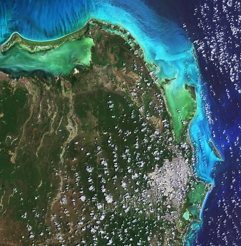
Cancún, situated in Quintana Roo on the northeast coast of Mexico’s Yucatán Peninsula, is featured in this image captured by the Copernicus Sentinel-2 mission.
Earth from Space: Cancún, Mexico
12.11.2021 10:00 ESA Observing the Earth
Cancún, situated in Quintana Roo on the northeast coast of Mexico’s Yucatán Peninsula, is featured in this image captured by the Copernicus Sentinel-2 mission.
Zrušení email adresy VFK.[kp]@cuzk.cz
12.11.2021 9:55 ČÚZK /Urady/Katastralni-urady/Katastralni-urady/Katastralni-urad-pro-Kralovehradecky-kraj/Katastralni-pracoviste/KP-Trutnov/O-uradu/Aktuality/Zruseni-email-adresy-VFK-kp-cuzk-czZrušení email adresy VFK.[kp]@cuzk.cz
12.11.2021 9:55 ČÚZK - předpisy a opatření Katastrální úřad pro Královéhradecký kraj zveřejnil novou aktualitu: Oznamujeme vám, že v souladu s pravidly pro vedení spisové služby katastrálních úřadů budou ke dni 1. ledna 2022 zrušeny emailové distribuční skupiny pro součinnost katastrálních pracovišť při vyhotovování geometrických plánů (obvykle ve tvaru: vfk.[KP]@cuzk.cz). Pokud nežádáte o součinnost při poskytování podkladů prostřednictvím WSGP, je třeba nadále podání týkající se součinnosti při vyhotovování geometrických plánů zasílat na adresu elektronické podatelny příslušného katastrálního pracoviště. Distribuční skupina vfk.trutnov@cuzk.cz bude zrušena, požadavky budou zasílány na kp.trutnov@cuzk.czZrušení email adresy VFK.[kp]@cuzk.cz
12.11.2021 9:55 ČÚZK - předpisy a opatření Český úřad zeměměřický a katastrální zveřejnil novou aktualitu: Oznamujeme vám, že v souladu s pravidly pro vedení spisové služby katastrálních úřadů budou ke dni 1. ledna 2022 zrušeny emailové distribuční skupiny pro součinnost katastrálních pracovišť při vyhotovování geometrických plánů (obvykle ve tvaru: vfk.[KP]@cuzk.cz). Pokud nežádáte o součinnost při poskytování podkladů prostřednictvím WSGP, je třeba nadále podání týkající se součinnosti při vyhotovování geometrických plánů zasílat na adresu elektronické podatelny příslušného katastrálního pracoviště. Distribuční skupina vfk.trutnov@cuzk.cz bude zrušena, požadavky budou zasílány na kp.trutnov@cuzk.czZrušení email adresy VFK.[kp]cuzk.cz
12.11.2021 9:52 ČÚZK - předpisy a opatření Katastrální úřad pro Královéhradecký kraj zveřejnil novou aktualitu: Oznamujeme vám, že v souladu s pravidly pro vedení spisové služby katastrálních úřadů budou ke dni 1. ledna 2022 zrušeny emailové distribuční skupiny pro součinnost katastrálních pracovišť při vyhotovování geometrických plánů (obvykle ve tvaru: vfk.[KP]@cuzk.cz). Pokud nežádáte o součinnost při poskytování podkladů prostřednictvím WSGP, je třeba nadále podání týkající se součinnosti při vyhotovování geometrických plánů zasílat na adresu elektronické podatelny příslušného katastrálního pracoviště. Distribuční skupina vfk.jicin@cuzk.cz bude zrušena, požadavky budou zasílány na kp.jicin@cuzk.czZrušení email adresy VFK.[kp]cuzk.cz
12.11.2021 9:52 ČÚZK /Urady/Katastralni-urady/Katastralni-urady/Katastralni-urad-pro-Kralovehradecky-kraj/Katastralni-pracoviste/KP-Jicin/O-uradu/Aktuality/Zruseni-email-adresy-VFK-kp-cuzk-czZrušení email adresy VFK.[kp]cuzk.cz
12.11.2021 9:52 ČÚZK - předpisy a opatření Český úřad zeměměřický a katastrální zveřejnil novou aktualitu: Oznamujeme vám, že v souladu s pravidly pro vedení spisové služby katastrálních úřadů budou ke dni 1. ledna 2022 zrušeny emailové distribuční skupiny pro součinnost katastrálních pracovišť při vyhotovování geometrických plánů (obvykle ve tvaru: vfk.[KP]@cuzk.cz). Pokud nežádáte o součinnost při poskytování podkladů prostřednictvím WSGP, je třeba nadále podání týkající se součinnosti při vyhotovování geometrických plánů zasílat na adresu elektronické podatelny příslušného katastrálního pracoviště. Distribuční skupina vfk.jicin@cuzk.cz bude zrušena, požadavky budou zasílány na kp.jicin@cuzk.czZrušení email adresy VFK.[kp]@cuzk.cz
12.11.2021 9:47 ČÚZK - předpisy a opatření Katastrální úřad pro Královéhradecký kraj zveřejnil novou aktualitu: Oznamujeme vám, že v souladu s pravidly pro vedení spisové služby katastrálních úřadů budou ke dni 1. ledna 2022 zrušeny emailové distribuční skupiny pro součinnost katastrálních pracovišť při vyhotovování geometrických plánů (obvykle ve tvaru: vfk.[KP]@cuzk.cz). Pokud nežádáte o součinnost při poskytování podkladů prostřednictvím WSGP, je třeba nadále podání týkající se součinnosti při vyhotovování geometrických plánů zasílat na adresu elektronické podatelny příslušného katastrálního pracoviště. Distribuční skupina vfk.hradeckralove@cuzk.cz bude zrušena, požadavky budou zasílány na kp.hkralove@cuzk.czZrušení email adresy VFK.[kp]cuzk.cz
12.11.2021 9:47 ČÚZK /Urady/Katastralni-urady/Katastralni-urady/Katastralni-urad-pro-Kralovehradecky-kraj/Katastralni-pracoviste/KP-Hradec-Kralove/O-uradu/Aktuality/Zruseni-email-adresy-VFK-kp-cuzk-czZrušení email adresy VFK.[kp]@cuzk.cz
12.11.2021 9:47 ČÚZK /Urady/Katastralni-urady/Katastralni-urady/Katastralni-urad-pro-Kralovehradecky-kraj/Katastralni-pracoviste/KP-Hradec-Kralove/O-uradu/Aktuality/Zruseni-email-adresy-VFK-kp-cuzk-czZrušení email adresy VFK.[kp]cuzk.cz
12.11.2021 9:47 ČÚZK - předpisy a opatření Český úřad zeměměřický a katastrální zveřejnil novou aktualitu: Oznamujeme vám, že v souladu s pravidly pro vedení spisové služby katastrálních úřadů budou ke dni 1. ledna 2022 zrušeny emailové distribuční skupiny pro součinnost katastrálních pracovišť při vyhotovování geometrických plánů (obvykle ve tvaru: vfk.[KP]@cuzk.cz). Pokud nežádáte o součinnost při poskytování podkladů prostřednictvím WSGP, je třeba nadále podání týkající se součinnosti při vyhotovování geometrických plánů zasílat na adresu elektronické podatelny příslušného katastrálního pracoviště. Distribuční skupina vfk.hradeckralove@cuzk.cz bude zrušena, požadavky budou zasílány na kp.hkralove@cuzk.czZrušení email adresy VFK.[kp]@cuzk.cz
12.11.2021 9:47 ČÚZK - předpisy a opatření Český úřad zeměměřický a katastrální zveřejnil novou aktualitu: Oznamujeme vám, že v souladu s pravidly pro vedení spisové služby katastrálních úřadů budou ke dni 1. ledna 2022 zrušeny emailové distribuční skupiny pro součinnost katastrálních pracovišť při vyhotovování geometrických plánů (obvykle ve tvaru: vfk.[KP]@cuzk.cz). Pokud nežádáte o součinnost při poskytování podkladů prostřednictvím WSGP, je třeba nadále podání týkající se součinnosti při vyhotovování geometrických plánů zasílat na adresu elektronické podatelny příslušného katastrálního pracoviště. Distribuční skupina vfk.hradeckralove@cuzk.cz bude zrušena, požadavky budou zasílány na kp.hkralove@cuzk.czGeoCue and BayesMap Announce StripAlign for True View EVO
12.11.2021 9:00 GISCafe.com Webcasts-Webinars GeoCue and BayesMap Announce StripAlign for True View EVOHuntsville, AL – GeoCue Group Inc. and BayesMap Solutions LLC are pleased to …
GeoCue Expands True View 3DIS® Line with True View 435
12.11.2021 9:00 GISCafe.com Webcasts-Webinars Huntsville, AL - GeoCue is excited to announce that we are, once again, expanding our line of True View 3D imaging sensors (3DIS®). The True View …Topcon Announces MC-X Platform and MC-Max Machine Control Solution
12.11.2021 3:43 GISCafe.com Webcasts-Webinars LIVERMORE, Calif. — (BUSINESS WIRE) — November 11, 2021 —Topcon Positioning Group has announced its MC-Max machine control …
Geonexus Launches Connector for Infor EAM, Providing Users with No-Code Approach to System Integration
12.11.2021 3:43 GISCafe.com Webcasts-Webinars The Infor EAM connector adds to Geonexus' growing library of connectorsANN ARBOR, Mich., Nov. 11, 2021 — (PRNewswire) —
ANN ARBOR, …
APGEO - Pozvánka na setkání zeměměřičů: ZLÍNGEO 2021
12.11.2021 1:00 Asociace podnikatelů v geomatice Srdečně vás zveme na již 4. ročník setkání zeměměřičů ve Zlíně.Import map do digitální knihovny Kramerius UK [Knihovna geografie, byTopic]
12.11.2021 0:00 Katedra aplikované geoinformatiky a kartografie Přf UK Na portál Digitalizace Univerzity Karlovy bylo nahráno přes 2 000 zdigitalizovaných map z Mapové sbírky PřF UK. Podívejte se na ukázky!Airbus and Northrop Grumman Lead Team Seeking to shape NATO’s Future Surveillance and Control New Atlantic Strategic Partnership for Advanced All-domain Resilient Operations (ASPAARO) brings together nine companies with world-leading capabilities @Airb
11.11.2021 20:59 GISCafe.com Webcasts-Webinars New Atlantic Strategic Partnership for Advanced All-domain Resilient Operations (ASPAARO) brings together nine companies with world-leading …Fortem Technologies Announces SkyDome System Long-Range Drone Mitigation at Dubai Airshow
11.11.2021 16:18 GISCafe.com Webcasts-Webinars PLEASANT GROVE, Utah, Nov. 11, 2021 — (PRNewswire) — Fortem Technologies, leaders in airspace security and defense for detecting and …Draganfly’s Vital Intelligence AI Selected by The Franklin County Sheriff’s Office
11.11.2021 16:18 GISCafe.com Webcasts-Webinars Los Angeles, CA., Nov. 11, 2021 (GLOBE NEWSWIRE) -- Draganfly Inc. (NASDAQ: DPRO) (CSE: DPRO) (FSE: 3U8) (“Draganfly" or the “Company”), an …20211111 - VŘ Správce DMVS
11.11.2021 15:36 ČÚZK - aktuality v resortu Oznámení o vyhlášení výběrového řízení na obsazení služebního místa rada/odborný rada - Správce DMVS.20211111 - VŘ Správce DMVS
11.11.2021 15:36 ČÚZK - předpisy a opatření Český úřad zeměměřický a katastrální zveřejnil novou aktualitu: Oznámení o vyhlášení výběrového řízení na obsazení služebního místa rada/odborný rada - Správce DMVS.Výběrové řízení
11.11.2021 14:07 ČÚZK - předpisy a opatření Katastrální úřad pro Liberecký kraj - Katastrální pracoviště Liberec zveřejnil novou aktualitu: Oznámení o vyhlášení výběrového řízení na obsazení služebního místa rada / odborný rada v oddělení právních vztahů na KP Liberec.Mapping our human footprint from space
11.11.2021 14:05 ESA Observing the Earth
The world’s population is expected to reach 9.7 billion in 2050, according to the UN Department of Economics and Social Affairs. Urban areas are already home to 55% of the world’s population and that figure is expected to grow to 68% by 2050. Rapid and unplanned urbanisation, combined with the challenges brought by climate change, can lead to an increase in air pollution, higher vulnerability to disasters, as well as issues related to the management of resources such as water, raw materials and energy.
To improve the understanding of current trends in global urbanisation, ESA and the German Aerospace Center (DLR), in collaboration with the Google Earth Engine team, are jointly developing the World Settlement Footprint – the world’s most comprehensive dataset on human settlement.
Termíny státních závěrečných zkoušek [Katedra aplikované geoinformatiky a kartografie, byTopic]
11.11.2021 14:00 Katedra aplikované geoinformatiky a kartografie Přf UK Termíny pro bakalářské a magisterské obory - zima 2021/2022.Výběrové řízení
11.11.2021 13:57 ČÚZK - předpisy a opatření Katastrální úřad pro Liberecký kraj zveřejnil novou aktualitu: Oznámení o vyhlášení výběrového řízení na obsazení služebního místa rada / odborný rada v oddělení právních vztahů na KP Liberec.Výběrové řízení
11.11.2021 13:57 ČÚZK /Urady/Katastralni-urady/Katastralni-urady/Katastralni-urad-pro-Liberecky-kraj/O-uradu/Aktuality/Vyberove-rizeni-(1)rada / odborný rada v oddělení právních vztahů k nemovitostem
11.11.2021 13:39 ČÚZK /Urady/Katastralni-urady/Katastralni-urady/Katastralni-urad-pro-Liberecky-kraj/Uredni-deska/Oznameni-a-jina-uredni-sdeleni/Volna-mista/rada-odborny-rada-v-oddeleni-pravnich-vztahu-k-(1)rada / odborný rada v oddělení právních vztahů k nemovitostem
11.11.2021 13:39 ČÚZK - předpisy a opatření Katastrální úřad pro Liberecký kraj - Katastrální pracoviště Liberecvypisuje výběrové řízení na místo
rada / odborný rada v oddělení právních vztahů k nemovitostem
rada / odborný rada v oddělení právních vztahů k nemovitostem
11.11.2021 13:39 ČÚZK - volná místa Katastrální úřad pro Liberecký kraj - Katastrální pracoviště Liberec vypisuje výběrové řízení na místo rada / odborný rada v oddělení právních vztahů k nemovitostemTuning in to Earth’s climate
11.11.2021 10:00 ESA Observing the Earth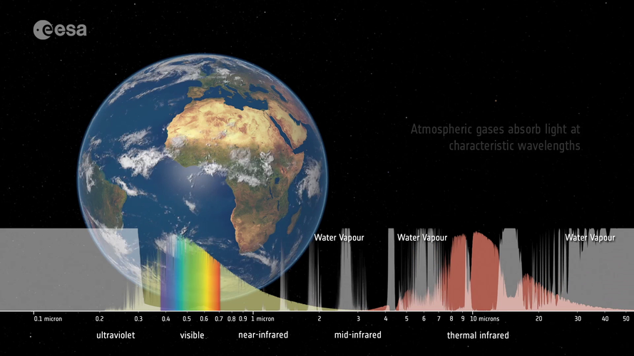 Video:
00:03:28
Video:
00:03:28
Satellites observe the Earth using a range of wavelengths on the electromagnetic spectrum. Different wavelengths allow us to probe different aspects of Earth’s land, atmosphere and ocean. By sampling the electromagnetic spectrum at multiple wavelengths, we can build a more complete picture of Earth’s complex climate system.
Aliance podepsala memorandum o spolupráci s Moravským leteckým klastrem
11.11.2021 9:26 UAVAPrezident Aliance pro bezpilotní letecký průmysl podepsal Memorandum o spolupráci s Moravským leteckým klastrem, který je také velmi aktivní v mezinárodní spolupráci a v našem oboru jsou stále větší překryvy, proto se těšíme na spolupráci. Více o Moravském leteckém klastru zde: http://www.aero-cluster.cz/
The post Aliance podepsala memorandum o spolupráci s Moravským leteckým klastrem appeared first on UAV Aliance pro bezpilotní letecký průmysl.
Odborný referent/vrchní referent – poskytování informací KN
11.11.2021 9:06 ČÚZK - předpisy a opatření Katastrální úřad pro Moravskoslezský kraj - Katastrální pracoviště Ostravavypisuje výběrové řízení na místo
Odborný referent/vrchní referent – poskytování informací KN
Odborný referent/vrchní referent – poskytování informací KN na Katastrálním pracovišti Opava
11.11.2021 9:06 ČÚZK - volná místa Katastrální úřad pro Moravskoslezský kraj - Katastrální pracoviště Ostrava vypisuje výběrové řízení na místo Odborný referent/vrchní referent – poskytování informací KN na Katastrálním pracovišti OpavaOdborný referent/vrchní referent – poskytování informací KN
11.11.2021 9:06 ČÚZK /Urady/Katastralni-urady/Katastralni-urady/Katastralni-urad-pro-Moravskoslezsky-kraj/Uredni-deska/Oznameni-a-jina-uredni-sdeleni/Volna-mista/DMS/Odborny-referent-vrchni-referent-–-poskytovani-infOdborný referent/vrchní referent – poskytování informací KN na Katastrálním pracovišti Opava
11.11.2021 9:06 ČÚZK - volná místa Katastrální úřad pro Moravskoslezský kraj Katastrální pracoviště Ostrava vypisuje výběrové řízení na místo Odborný referent/vrchní referent – poskytování informací KN na Katastrálním pracovišti OpavaOdborný referent/vrchní referent – poskytování informací KN na Katastrálním pracovišti Opava
11.11.2021 9:06 ČÚZK - předpisy a opatření Katastrální úřad pro Moravskoslezský kraj Katastrální pracoviště Ostravavypisuje výběrové řízení na místo
Odborný referent/vrchní referent – poskytování informací KN na Katastrálním pracovišti Opava
Odborný referent/vrchní referent – poskytování informací KN
11.11.2021 9:06 ČÚZK - volná místa Katastrální úřad pro Moravskoslezský kraj - Katastrální pracoviště Ostrava vypisuje výběrové řízení na místo Odborný referent/vrchní referent – poskytování informací KNOdborný referent/vrchní referent – poskytování informací KN na Katastrálním pracovišti Opava
11.11.2021 9:06 ČÚZK - předpisy a opatření Katastrální úřad pro Moravskoslezský kraj - Katastrální pracoviště Ostravavypisuje výběrové řízení na místo
Odborný referent/vrchní referent – poskytování informací KN na Katastrálním pracovišti Opava
Vrchní referent/rada – obnova katastrálního operátu
11.11.2021 8:58 ČÚZK - volná místa Katastrální úřad pro Moravskoslezský kraj - Katastrální pracoviště Opava vypisuje výběrové řízení na místo Vrchní referent/rada – obnova katastrálního operátuVrchní referent/rada – obnova katastrálního
11.11.2021 8:58 ČÚZK - předpisy a opatření Katastrální úřad pro Moravskoslezský kraj Katastrální pracoviště Opavavypisuje výběrové řízení na místo
Vrchní referent/rada – obnova katastrálního
Vrchní referent/rada – obnova katastrálního operátu
11.11.2021 8:58 ČÚZK - předpisy a opatření Katastrální úřad pro Moravskoslezský kraj - Katastrální pracoviště Opavavypisuje výběrové řízení na místo
Vrchní referent/rada – obnova katastrálního operátu
Vrchní referent/rada – obnova katastrálního operátu
11.11.2021 8:58 ČÚZK /Urady/Katastralni-urady/Katastralni-urady/Katastralni-urad-pro-Moravskoslezsky-kraj/Uredni-deska/Oznameni-a-jina-uredni-sdeleni/Volna-mista/DMS/Vrchni-referent-rada-–-obnova-katastralniho-(2)Vrchní referent/rada – obnova katastrálního
11.11.2021 8:58 ČÚZK - volná místa Katastrální úřad pro Moravskoslezský kraj Katastrální pracoviště Opava vypisuje výběrové řízení na místo Vrchní referent/rada – obnova katastrálníhoVrchní referent/rada – obnova katastrálního
11.11.2021 8:58 ČÚZK /Urady/Katastralni-urady/Katastralni-urady/Katastralni-urad-pro-Moravskoslezsky-kraj/Uredni-deska/Oznameni-a-jina-uredni-sdeleni/Volna-mista/DMS/Vrchni-referent-rada-–-obnova-katastralniho-(2)Vrchní referent/rada – obnova katastrálního operátu
11.11.2021 8:54 ČÚZK /Urady/Katastralni-urady/Katastralni-urady/Katastralni-urad-pro-Moravskoslezsky-kraj/Uredni-deska/Oznameni-a-jina-uredni-sdeleni/Volna-mista/DMS/Vrchni-referent-rada-–-obnova-katastralniho-(1)Vrchní referent/rada – obnova katastrálního operátu
11.11.2021 8:54 ČÚZK - předpisy a opatření Katastrální úřad pro Moravskoslezský kraj - Katastrální pracoviště Opavavypisuje výběrové řízení na místo
Vrchní referent/rada – obnova katastrálního operátu
Vrchní referent/rada – obnova katastrálního
11.11.2021 8:54 ČÚZK - předpisy a opatření Katastrální úřad pro Moravskoslezský kraj Katastrální pracoviště Opavavypisuje výběrové řízení na místo
Vrchní referent/rada – obnova katastrálního
Vrchní referent/rada – obnova katastrálního operátu
11.11.2021 8:54 ČÚZK - volná místa Katastrální úřad pro Moravskoslezský kraj - Katastrální pracoviště Opava vypisuje výběrové řízení na místo Vrchní referent/rada – obnova katastrálního operátuVrchní referent/rada – obnova katastrálního
11.11.2021 8:54 ČÚZK /Urady/Katastralni-urady/Katastralni-urady/Katastralni-urad-pro-Moravskoslezsky-kraj/Uredni-deska/Oznameni-a-jina-uredni-sdeleni/Volna-mista/DMS/Vrchni-referent-rada-–-obnova-katastralniho-(1)Vrchní referent/rada – obnova katastrálního
11.11.2021 8:54 ČÚZK - volná místa Katastrální úřad pro Moravskoslezský kraj Katastrální pracoviště Opava vypisuje výběrové řízení na místo Vrchní referent/rada – obnova katastrálníhoOrganizačný tím Stavebnej fakulty STU pozýva na online GIS Day 2021
11.11.2021 8:45 GISportal.cz
Milí GIS priatelia, radi by sme Vás pozvali na oslavu medzinárodného dňa geografických informačných systémov GIS Day, ktorá sa uskutoční v utorok 16.11.2021 od 15:00 cez platformu MS Teams. Registrácia vopred nie je potrebná. Už po tretíkrát tím z katedry Globálnej geodézie a geoinformatiky a katedry Vodného hospodárstva krajiny SvF pripravil prednášky a workshopy, ktoré […]
The post Organizačný tím Stavebnej fakulty STU pozýva na online GIS Day 2021 appeared first on GISportal.cz.
Odborný referent/vrchní referent – obnova
11.11.2021 8:42 ČÚZK - volná místa Katastrální úřad pro Moravskoslezský kraj Katastrální pracoviště Frýdek-Místek vypisuje výběrové řízení na místo Odborný referent/vrchní referent – obnovaOdborný referent/vrchní referent – obnova
11.11.2021 8:42 ČÚZK - předpisy a opatření Katastrální úřad pro Moravskoslezský kraj Katastrální pracoviště Frýdek-Místekvypisuje výběrové řízení na místo
Odborný referent/vrchní referent – obnova
Odborný referent/vrchní referent – obnova katastrálního operátu
11.11.2021 8:42 ČÚZK /Urady/Katastralni-urady/Katastralni-urady/Katastralni-urad-pro-Moravskoslezsky-kraj/Uredni-deska/Oznameni-a-jina-uredni-sdeleni/Volna-mista/DMS/Odborny-referent-vrchni-referent-–-obnovaOdborný referent/vrchní referent – obnova
11.11.2021 8:42 ČÚZK /Urady/Katastralni-urady/Katastralni-urady/Katastralni-urad-pro-Moravskoslezsky-kraj/Uredni-deska/Oznameni-a-jina-uredni-sdeleni/Volna-mista/DMS/Odborny-referent-vrchni-referent-–-obnovaOdborný referent/vrchní referent – obnova katastrálního operátu
11.11.2021 8:42 ČÚZK - předpisy a opatření Katastrální úřad pro Moravskoslezský kraj - Katastrální pracoviště Frýdek-Místekvypisuje výběrové řízení na místo
Odborný referent/vrchní referent – obnova katastrálního operátu
Odborný referent/vrchní referent – obnova katastrálního operátu
11.11.2021 8:42 ČÚZK - volná místa Katastrální úřad pro Moravskoslezský kraj - Katastrální pracoviště Frýdek-Místek vypisuje výběrové řízení na místo Odborný referent/vrchní referent – obnova katastrálního operátuVrchní referent/rada – obnova katastrálního operátu
11.11.2021 8:36 ČÚZK /Urady/Katastralni-urady/Katastralni-urady/Katastralni-urad-pro-Moravskoslezsky-kraj/Uredni-deska/Oznameni-a-jina-uredni-sdeleni/Volna-mista/DMS/Vrchni-referent-rada-–-obnova-katastralnihoVrchní referent/rada – obnova katastrálního operátu
11.11.2021 8:36 ČÚZK - předpisy a opatření Katastrální úřad pro Moravskoslezský kraj - technický odborvypisuje výběrové řízení na místo
Vrchní referent/rada – obnova katastrálního operátu
Vrchní referent/rada – obnova katastrálního
11.11.2021 8:36 ČÚZK - volná místa Katastrální úřad pro Moravskoslezský kraj technický odbor vypisuje výběrové řízení na místo Vrchní referent/rada – obnova katastrálníhoVrchní referent/rada – obnova katastrálního operátu
11.11.2021 8:36 ČÚZK - volná místa Katastrální úřad pro Moravskoslezský kraj - technický odbor vypisuje výběrové řízení na místo Vrchní referent/rada – obnova katastrálního operátuVrchní referent/rada – obnova katastrálního
11.11.2021 8:36 ČÚZK - předpisy a opatření Katastrální úřad pro Moravskoslezský kraj technický odborvypisuje výběrové řízení na místo
Vrchní referent/rada – obnova katastrálního
Vrchní referent/rada – obnova katastrálního
11.11.2021 8:36 ČÚZK /Urady/Katastralni-urady/Katastralni-urady/Katastralni-urad-pro-Moravskoslezsky-kraj/Uredni-deska/Oznameni-a-jina-uredni-sdeleni/Volna-mista/DMS/Vrchni-referent-rada-–-obnova-katastralnihoRada/odborný rada-vedoucí oddělení aktualizace PI KN na Katastrálním pracovišti Brno - město
11.11.2021 8:08 ČÚZK /Urady/Katastralni-urady/Katastralni-urady/Katastralni-urad-pro-Jihomoravsky-kraj/Uredni-deska/Oznameni-a-jina-uredni-sdeleni/Volna-mista/DMS/Rada-odborny-rada-vedouci-oddeleni-aktualizace-(1)Rada/odborný rada-vedoucí oddělení aktualizace PI KN na Katastrálním pracovišti Brno - město
11.11.2021 8:08 ČÚZK - volná místa Katastrální úřad pro Jihomoravský kraj Katastrální pracoviště Brno-město vypisuje výběrové řízení na místo Rada/odborný rada-vedoucí oddělení aktualizace PI KN na Katastrálním pracovišti Brno - městoRada/odborný rada-vedoucí oddělení aktualizace PI KN na Katastrálním pracovišti Brno - město
11.11.2021 8:08 ČÚZK - předpisy a opatření Katastrální úřad pro Jihomoravský kraj Katastrální pracoviště Brno-městovypisuje výběrové řízení na místo
Rada/odborný rada-vedoucí oddělení aktualizace PI KN na Katastrálním pracovišti Brno - město
Rada/odborný rada v oddělení aktualizace KN č.2 na Katastrálním pracovišti Znojmo
11.11.2021 8:05 ČÚZK - volná místa Katastrální úřad pro Jihomoravský kraj Katastrální pracoviště Znojmo vypisuje výběrové řízení na místo Rada/odborný rada v oddělení aktualizace KN č.2 na Katastrálním pracovišti ZnojmoRada/odborný rada v oddělení aktualizace KN č.2 na Katastrálním pracovišti Znojmo
11.11.2021 8:05 ČÚZK /Urady/Katastralni-urady/Katastralni-urady/Katastralni-urad-pro-Jihomoravsky-kraj/Uredni-deska/Oznameni-a-jina-uredni-sdeleni/Volna-mista/DMS/Rada-odborny-rada-v-oddeleni-aktualizace-KN-c-2-naRada/odborný rada v oddělení aktualizace KN č.2 na Katastrálním pracovišti Znojmo
11.11.2021 8:05 ČÚZK - předpisy a opatření Katastrální úřad pro Jihomoravský kraj Katastrální pracoviště Znojmovypisuje výběrové řízení na místo
Rada/odborný rada v oddělení aktualizace KN č.2 na Katastrálním pracovišti Znojmo
XAG Launches V40 and P40 Agricultural Drone Globally to Benefit More Farmers
11.11.2021 1:17 GISCafe.com Webcasts-Webinars GUANGZHOU, China, Nov. 10, 2021 — (PRNewswire) — XAG, the trailblazers of agriculture robotics and AI, has geared up to launch its V40 …Innoviz Technologies Reports Third Quarter 2021 Operational and Financial Results
11.11.2021 1:17 GISCafe.com Webcasts-Webinars Distinguished Guest from BMW to Join Management on Conference Call Scheduled Today at 9:00 AM ETTEL AVIV, Israel, Nov. 10, 2021 — (PRNewswire) …
D-Fend Solutions, Sole Cyber-Takeover Provider at INTERPOL's Full-Scale Counter-Drone Airport Exercise, Successfully Took Control of a Long-Range Drone
11.11.2021 1:15 GISCafe.com Webcasts-Webinars D-Fend Solutions showcased its unique detection, accurate location and cyber mitigation capabilities in Oslo, Norway, during the three-day …CareAR Highlights Innovation at Augmented World Expo (AWE) with Launch of CareAR® Instruct, Drone Support, and Acquisition of CraftAR
11.11.2021 1:15 GISCafe.com Webcasts-Webinars CareAR president to present "Reinventing the Service Experience" on main stageSANTA CLARA, Calif., Nov. 10, 2021 — (PRNewswire) — …
Planet to Acquire VanderSat to Deliver Advanced Agriculture Data Products to Customers
11.11.2021 1:15 GISCafe.com Webcasts-Webinars SAN FRANCISCO & HAARLEM, Netherlands — (BUSINESS WIRE) — November 10, 2021 —Planet, a leading provider of daily data and …
Woolpert Selected by NOAA for $49M Coastal Geospatial Services Contract
11.11.2021 1:15 GISCafe.com Webcasts-Webinars Woolpert will provide topo-bathy lidar data acquisition and processing, survey and GIS services, geospatial training and more under this five-year, …Smart City Water Develops a New Approach to Reduce Urban Flooding
11.11.2021 1:15 GISCafe.com Webcasts-Webinars TORONTO, Nov. 10, 2021 — (PRNewswire) — Smart City Water Inc., a drainage asset management software and service company for the …Leidos Awarded Contract to Support UK MOD PICASSO programme
11.11.2021 1:15 GISCafe.com Webcasts-Webinars LONDON, Nov. 10, 2021 — (PRNewswire) — Leidos (NYSE: LDOS), a FORTUNE® 500 science and technology leader, was recently …8. Děčínský dialog o vodě 30. 11. 2021
11.11.2021 0:00 Státní pozemkový úřad V pořadí již osmý ročník konference Děčínský dialog o vodě proběhne letos v úterý 30. listopadu v době od 14.00 do zhruba 17.00 hodin v prostorách Magistrátu města Děčín v ulici 28. října 2. Hlavním tématem budou Hydro-meteorologické dopady a další hrozby, protiopatření a inspirace. Akci, kterou organizuje Spolek Aquarius-Vodnář (SVA), podporují Státní pozemkový úřad - Pobočka Děčín a Magistrát města Děčín.8. Děčínský dialog o vodě 30. 11. 2021
11.11.2021 0:00 Státní pozemkový úřad V pořadí již osmý ročník konference Děčínský dialog o vodě proběhne letos v úterý 30. listopadu v době od 14.00 do zhruba 17.00 hodin v prostorách Magistrátu města Děčín v ulici 28. října 2. Hlavním tématem budou Hydro-meteorologické dopady a další hrozby, protiopatření a inspirace. Akci, kterou organizuje Spolek Aquarius-Vodnář (SVA), podporují Státní pozemkový úřad - Pobočka Děčín a Magistrát města Děčín.Structural Gymnastics in the Transportation Center
10.11.2021 19:06 Bentley SystemsPressCoverage
Structure Magazine, USA
Read the articleDesign and Construction of the Worlds Tallest Rail Pier Girder Bridge
10.11.2021 18:41 Bentley SystemsPressCoverage
Rail Analysis, India
Read the articleCase Study on PGESCo using Bentley Applications for $460 Mn Power Station Project
10.11.2021 18:16 Bentley SystemsPressCoverage
Energetica India, India
Read the articleWhy Leveraging Digital Tools for Optimized Project Data Matters
10.11.2021 17:30 Bentley SystemsPressCoverage
ENR, USA
Read the articleZnečištěné ovzduší
10.11.2021 17:23 Jihočeský krajMapová aplikace Znečištění ovzduší byla aktualizována o pětileté průměry z let 2016-2020.
VR do 30.11.2021 vrchní referent/rada – vedení katastrální map
10.11.2021 16:56 ČÚZK - předpisy a opatření Katastrální úřad pro hlavní město Prahu - Katastrální pracoviště Praha zveřejnil novou aktualitu: Ředitelka úřadu vyhlašuje výběrové řízení na systematizované služební místo:vrchní referent/rada – vedení katastrální mapy
VR do 30.11.2021 vrchní referent/rada – vedení katastrální map
10.11.2021 16:56 ČÚZK /Urady/Katastralni-urady/Katastralni-urady/Katastralni-urad-pro-hlavni-mesto-Prahu/O-uradu/Aktuality/VR-do-30-11-2021-vrchni-referent-rada-–-vedeni-katreferent/rada – vedení katastrální mapy
10.11.2021 16:38 ČÚZK - předpisy a opatření Katastrální úřad pro hlavní město Prahu Katastrální pracoviště Prahavypisuje výběrové řízení na místo
referent/rada – vedení katastrální mapy
referent/rada – vedení katastrální mapy
10.11.2021 16:38 ČÚZK - volná místa Katastrální úřad pro hlavní město Prahu Katastrální pracoviště Praha vypisuje výběrové řízení na místo referent/rada – vedení katastrální mapyreferent/rada – vedení katastrální mapy
10.11.2021 16:38 ČÚZK /Urady/Katastralni-urady/Katastralni-urady/Katastralni-urad-pro-hlavni-mesto-Prahu/Uredni-deska/Oznameni-a-jina-uredni-sdeleni/Volna-mista/DMS/referent-rada-–-vedeni-katastralni-mapyCarbon dioxide monitoring satellite given the shakes
10.11.2021 15:25 ESA Observing the Earth
A new satellite destined to be Europe’s prime mission for monitoring and tracking carbon dioxide emissions from human activity is being put through its paces at ESA’s Test Centre in the Netherlands. With nations at COP26 pledging net-zero emissions by 2050, the pressure is on to reduce the amount of greenhouse gases we pump into the atmosphere – but the race is also on to support the monitoring that shows targets are being met. ESA, the European Commission, Eumetsat and industrial partners are therefore working extremely hard to get the Copernicus Anthropogenic Carbon Dioxide Monitoring mission ready for liftoff in 2025.
Stav komunikací II. a III. třídy
10.11.2021 13:39 Jihočeský krajMapová aplikace Stav komunikací II. a III. třídy byla aktualizována o rok 2020.
Nová podoba Geoportálu
10.11.2021 13:39 Jihočeský krajDne 17.3.2021 byla nasazena nová podoba Geoportálu Jihočeského kraje. V průběhu týdne budou ještě laděny a upravovány pokročilé funkcionality. Děkujeme za pochopení.
Aktualizace dat v mapových aplikacích
10.11.2021 13:39 Jihočeský krajData katastru nemovitostí (DKM, KMD, KM-D) byla v mapových aplikacích i výdejním modulu aktualizována k 1. 1. 2021.
Mapová aplikace ÚPD - nové dokumentace
10.11.2021 13:39 Jihočeský krajV mapové aplikaci Územně plánovací dokumentace obcí byla aktualizována ÚPD obcí ORP Trhové Sviny - Svatý Jan nad Malší, ORP Jindřichův Hradec - Nová Bystřice, ORP České Budějovice - Štěpánovice, Ledenice, Hůry, ORP Týn nad Vltavou - Dolní Bukovsko.
Mapa administrativního členění 2021
10.11.2021 13:39 Jihočeský krajV sekci Ke stažení je k dispozici aktualizovaná mapa administrativního členění k 1.7.2021 v rozměru mapy A1 za Jihočeský kraj.
Odstávka Geoportálu Jihočeského kraje
10.11.2021 13:39 Jihočeský krajOd středy 10.3.2021 přibližně do pondělí 15.3.2021 nebude možné žádat a vydávat data z Geoportálu z důvodu upgrade aplikačních komponent Geoportálu. Finální termín obnovení možnosti výdejů dat bude zveřejněn zde v aktualitách. Děkujeme za pochopení.
Mapová aplikace ÚPD - nové dokumentace
10.11.2021 13:39 Jihočeský krajV mapové aplikaci Územně plánovací dokumentace obcí byla aktualizována ÚPD obcí ORP České Budějovice - Hluboká nad Vltavou, Rudolfov, Sedlec, Dubičné, Vrábče, Olešník.
Mapová aplikace Investiční akce na silnicích v roce 2021
10.11.2021 13:39 Jihočeský krajByla vytvořena mapová aplikace Investiční akce na silnicích v roce 2021, zobrazujícín investiční akce/uzavírky na silnicích Jihočeského kraje realizovaných v průběhu roku 2021.
Aktualizace otevřených dat zastávek veřejné dopravy v Jihočeském kraji
10.11.2021 13:39 Jihočeský krajV sekci Doprava a silniční hospodářství byla aktualizována data zastávek veřejné dopravy v Jihočeském kraji k 17.6.2021. Data jsou k dispozici ke stažení pod licencí CC0 nebo pomocí webových služeb (WMS, WFS) či k zobrazení v mapové aplikaci.
Publikace mapových služeb - TLS
10.11.2021 13:39 Jihočeský krajOd ledna 2022 přestanou být webové služby Geoportálu poskytovány přes protokol TLSv1.0 a TLSv1.1. V provozu zůstanou varianty s TLSv1.2 a TLSv1.3.
Aktualizace dat v mapových aplikacích
10.11.2021 13:39 Jihočeský krajData katastru nemovitostí (DKM, KMD, KM-D a ÚKM) byla v mapových aplikacích a výdejním moduli aktualizována k 1.10.2021.
rnrn
Neudržované úseky silnic - aktualizace
10.11.2021 13:39 Jihočeský krajV sekci Doprava a silniční hospodářství byla aktualizována mapová aplikace Neudržované úseky silnic. Najdete v ní úseky silnic II. a III. třídy, na kterých se pro jejich malý dopravní význam nezajišťuje sjízdnost a schůdnost odstraňováním sněhu a náledí v zimním období. Silnice byly vybrány nařízením kraje č. 21/2021 ze dne 16.9.2021.
Mapová aplikace - Císařské otisky stabilního katastru
10.11.2021 13:39 Jihočeský krajNa Geoportálu byla zveřejněna mapová aplikace znázorňující georeferencované rastry Císařských otisků stabilního katastru. Mapování proběhlo v letech 1824 - 1843 na území Rakouska-Uherska a to v měřítku 1:2880.
Aktualizovaná data ze ZÚR
10.11.2021 13:39 Jihočeský krajV sekci Data ze ZÚR jsou k dispozici ke stažení aktualizovaná vektorová data ze Zásad územního rozvoje Jihočeského kraje a to v měřítku 1:100000. Data jsou dostupná ve formátech SHP, DGN, DWG, FGDB pod licencí CC0 (Public Domain).
Mapová aplikace ÚPD - nové dokumentace
10.11.2021 13:39 Jihočeský krajV mapové aplikaci Územně plánovací dokumentace obcí byla aktualizována ÚPD obcí ORP Tábor – Bečice, Sezimovo Ústí, ORP Písek – Rakovice, ORP Prachatice – Vlachovo Březí, ORP Vimperk – Čkyně, Kvilda, ORP Vodňany - Vodňany.
Mapová aplikace ÚPD - nové dokumentace
10.11.2021 13:39 Jihočeský krajV mapové aplikaci Územně plánovací dokumentace obcí byla aktualizována ÚPD obcí ORP Písek – Kožlí, ORP Tábor – Ratibořské Hory, ORP Písek – Písek, ORP České Budějovice – Doudleby, Litvínovice
Aktualizace otevřených dat zastávek veřejné dopravy v Jihočeském kraji
10.11.2021 13:39 Jihočeský krajV sekci Doprava a silniční hospodářství byla aktualizována data zastávek veřejné dopravy v Jihočeském kraji k 29.9.2021. Data jsou k dispozici ke stažení pod licencí CC0 nebo pomocí webových služeb (WMS, WFS) či k zobrazení v mapové aplikaci.
Územní studie krajiny Jihočeského kraje
10.11.2021 13:39 Jihočeský krajOdbor regionálního rozvoje, územního plánování a stavebního řádu KÚ JčK schválil k datu 1.9.2021 možnost využití ÚZEMNÍ STUDIE KRAJINY JIHOČESKÉHO KRAJE.
Mapová aplikace ÚPD - nové dokumentace
10.11.2021 13:39 Jihočeský krajV mapové aplikaci Územně plánovací dokumentace obcí byla aktualizována ÚPD obcí ORP České Budějovice - Žabovřesky, ORP Prachatice - Babice, Hracholusky, Prachatice.
Aktualizace dat v mapových aplikacích
10.11.2021 13:39 Jihočeský krajData katastru nemovitostí (DKM, KMD, KM-D) byla v mapových aplikacích i výdejním modulu aktualizována k 1. 7. 2021.
Mapová aplikace ÚPD - nové dokumentace
10.11.2021 13:39 Jihočeský krajV mapové aplikaci Územně plánovací dokumentace obcí byla aktualizována ÚPD obcí ORP Jindřichův Hradec – Stráž nad Nežárkou, Kardašova Řečice, ORP Český Krumlov – Český Krumlov, ORP Milevsko – Stehlovice, ORP Třeboň - Třeboň, ORP Soběslav - Řípec
Odstávka mapových aplikací Geoportálu a výdeje dat
10.11.2021 13:39 Jihočeský krajOd pátka 5.11.2021 od 16:00 budou z technických důvodů nedostupné mapové aplikace Geoportálu a nebude možné žádat o výdej dat. Obnovení plného provozu předpokládáme v neděli 7.11.2021 ve večerních hodinách. O případném dřívějším obnovení plného provozu budeme informovat.
rnrnOmlouváme se za komplikace
Aktualizace dat v mapových aplikacích
10.11.2021 13:39 Jihočeský krajData katastru nemovitostí (DKM, KMD, KM-D a ÚKM) byla v mapových aplikacích i výdejním modulu aktualizována k 1. 4. 2021.