


![]()

zprávy
zdroje zpráv:80. setkání členů SFDP
5.11.2021 8:22 Společnost pro fotogrammetrii a dálkový průzkumV úterý 19.10. 2021 na FSv ČVUT proběhlo výroční „80. setkání“ našeho spolku, seminář „Nová legislativa v oblasti dronů“. Akci moderoval prof. Dr. Ing. Karel Pavelka. Přednášeli Ing. Jakub Karas (http://upvision.cz) a Ing. Zdeněk Svatý, Ph.D. (FD ČVUT, Ústav soudního znalectví v dopravě e-mail: svaty@fd.cvut.cz). Přednášky byly široce diskutovány přítomnými a potvrdily aktuálnost tématu pro většinu našich členů. Oba přednášející prokázali vysoké odborné znalosti a praktické zkušenosti v uvedené problamatice.
The post 80. setkání členů SFDP appeared first on SFDP.
80. setkání členů SFDP
5.11.2021 8:22 Společnost pro fotogrammetrii a dálkový průzkumV úterý 19.10. 2021 na FSv ČVUT proběhlo výroční „80. setkání“ našeho spolku, seminář „Nová legislativa v oblasti dronů“. Akci moderoval prof. Dr. Ing. Karel Pavelka. Přednášeli Ing. Jakub Karas (http://upvision.cz) a Ing. Zdeněk Svatý, Ph.D. (FD ČVUT, Ústav soudního znalectví v dopravě e-mail: svaty@fd.cvut.cz). Přednášky byly široce diskutovány přítomnými a potvrdily aktuálnost tématu pro většinu našich členů. Oba přednášející prokázali vysoké odborné znalosti a praktické zkušenosti v uvedené problamatice.
The post 80. setkání členů SFDP appeared first on SFDP.
79. setkání členů SFDP
5.11.2021 8:20 Společnost pro fotogrammetrii a dálkový průzkumV rámci 79. setkání členů SFDP jsme měli návštívit nejnižší a nejvyšší místa Moravskoslezských Beskyd. Dvoudenní setkání organizovali ve dnech 21. – 22. září 2021 Hana Staňková, Pavel Černota a Jiří Pospíšil ve spolupráci s Katedrou geodézie a důlního měřictví Hornicko-geologické fakulty VŠB – Technické univerzity Ostrava. Tím nejnižším místem byl důl Paskov, kde jsme sfárali do hloubky 920 m pod povrchem a tento výjimečný zážitek byl ještě zvýšen následným sfáráním do hloubky 1121 m pod povrchem země (815,59 m pod hladinou moře). Po absolvování tohoto mimořádného zážitku byl zajištěn převoz do Kozlovic, kde bylo v areálu „Na Mlýně“ zajištěno pohoštění, ubytování a následně zde probíhal ve společenských prostorách odpolední a večerní program. V rámci odborného programu nám prof. Haka Staňková představila svoji práci a rovněž tak program Katedry geodézie a důlního měřictví. Následoval společenský večer, v rámci kterého byla naše předsedkyně Lena Halounová a také Karel Vach pasováni na čestné občany VALAŠSKÉHO KRÁLOVSTVÍ. Druhý den byl zajištěn speciální autobus, který nás po ránu odvezl na nejvyšší místo Moravskoslezských Beskyd – na Lysou horu (1324 m n.m.). Počasí nám sice úplně nepřálo, ale plánovaného cíle jsme dosáhli. Navštívili jsme nejnižší a nejvyšší místo Moravskoslezských Beskyd. Organizátoři setkání odvedli skvělou práci.
The post 79. setkání členů SFDP appeared first on SFDP.
78. setkání členů SFDP
5.11.2021 8:18 Společnost pro fotogrammetrii a dálkový průzkumNa restaurační lodi Hamburk proběhlo ve středu 16. 6. 2021 plenární zasedání (78. setkání členů SFDP). Splnili jsme vše v plánovaném čase. Děkujeme všem členům za zodpovědný přístup. Po plenárce proběhl raut, krásná projížďka po Vltavě za mimořádně příjemného počasí.
The post 78. setkání členů SFDP appeared first on SFDP.
Geo Week Award Ceremony Nominations for Excellence in the Geospatial Market Accepted Through Dec 1
5.11.2021 8:00 GISCafe.com Webcasts-Webinars LIDAR Leader Awards and Younger Geospatial Professional Awards to celebrate excellence in the geospatial market in Denver, February 7, 2022 …Autodesk Extends Invitation to Join Financial Results Conference Call
5.11.2021 8:00 GISCafe.com Webcasts-Webinars Third Quarter Fiscal 2022 Financial Results Conference Call to be Held Tuesday, November 23, 2021, 2:00 p.m. PTSAN FRANCISCO, Nov. 4, 2021 — …
Třetí dekáda firmy Hrdlička ve znamení rozvoje, ocenění a vzniku nových služeb
5.11.2021 2:21 ZeměměřičV předchozích dvou článcích o firmě Hrdlička jsme se věnovali letům 1991 až 2010. Ve třetím desetiletí má firma již svoje pevné místo na trhu a může tak přemýšlet, jaké další služby by se daly zákazníkům nabídnout. Díky informačním technologiím se firma rozvíjí na geomatickou společnost. Třetí dekáda je také ve znamení sbírání ocenění a zakládání, případně nákupů podílů […]
The post Třetí dekáda firmy Hrdlička ve znamení rozvoje, ocenění a vzniku nových služeb appeared first on Zeměměřič.
Velodyne Lidar Reports Third Quarter 2021 Financial Results
5.11.2021 2:13 GISCafe.com Webcasts-Webinars Proven technology executive, Dr. Theodore L. Tewksbury, to join Velodyne as Chief Executive Officer on November 10, 202135 total active multi-year …
Novinky v programech Revit Tools a Civil Tools
5.11.2021 0:20 Arkance SystemsPodívejte se na nové funkce, vylepšení a další novinky ve dvou aplikacích z vlastního vývoje Arkance Systems
Zpráva Novinky v programech Revit Tools a Civil Tools pochází z arkance-systems.cz.
Pozvánka na sympozium Z dějin geodézie a kartografie [Knihovna geografie, byTopic]
5.11.2021 0:00 Katedra aplikované geoinformatiky a kartografie Přf UK Tradiční podzimní setkání – již XLI. sympozium Z dějin geodézie a kartografie – se koná v Národním technickém muzeu v Praze ve středu 24. 11. 2021 od 9 hodin.Cambridge Seminars in the History of Cartography 2021-2022 [Knihovna geografie, byTopic]
5.11.2021 0:00 Katedra aplikované geoinformatiky a kartografie Přf UK Zájemce o historickou kartografii upozorňujeme na cyklus online seminářů University of Cambridge. První z nich se koná již 16. listopadu na téma "At the limits of China: frontiers, borders, and political geography in early modern Sino-Western cartographic exchanges".Informace ke knižním akvizicím [Knihovna geografie, byTopic]
5.11.2021 0:00 Katedra aplikované geoinformatiky a kartografie Přf UK Akvizice, které je možné objednat prostřednictvím Knihovny geografie, se pro tento rok uzavírají k datu 15.11.2021.Vector and ATL Joint Venture Awarded DOE Contract to Provide Blue Small Unmanned Aircraft Systems Services
4.11.2021 19:30 GISCafe.com Webcasts-Webinars GAITHERSBURG, Md., Nov. 04, 2021 (GLOBE NEWSWIRE) -- Hanford Mission Integration Solutions (HMIS) has awarded Vector Innovative Solutions, LLC …Lenovo Group: Second Quarter Results 2021/22
4.11.2021 17:34 GISCafe.com Webcasts-Webinars Lenovo delivers record quarter, as strategy continues to drive transformation and sustainable growth, with profitability on track to double in three …BCE reports third quarter 2021 results
4.11.2021 17:34 GISCafe.com Webcasts-Webinars MONTRÉAL, Nov. 4, 2021 — (PRNewswire) —This news release contains forward-looking statements. For a description of the related risk …
Ouster Introduces Digital Flash Series Lidar for Automotive
4.11.2021 17:34 GISCafe.com Webcasts-Webinars The digital flash (DF) series offers a suite of solid-state lidar sensors with the performance, reliability, and affordability needed for automotive …Woolpert Selected to Collect Aerial Lidar Data for Ohio 3DEP
4.11.2021 17:34 GISCafe.com Webcasts-Webinars The data collected will support the U.S. Geological Survey's 3D Elevation Program and will benefit agencies, governments and individuals across the …Novinka Trimble DA2
4.11.2021 15:39 GeotronicsSoftwarový přijímač nové generace pro GNSS službu Trimble Catalyst.
The post Novinka Trimble DA2 first appeared on GEOTRONICS Praha.
Novinka Trimble DA2
4.11.2021 15:39 Geotronics Softwarový přijímač nové generace pro GNSS službu Trimble Catalyst.Melt
4.11.2021 15:00 ESA Observing the Earth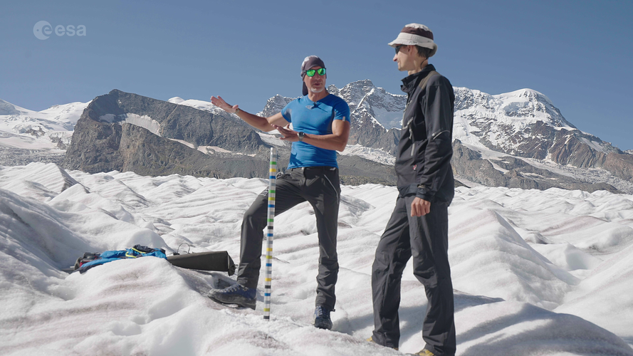 Video:
00:31:09
Video:
00:31:09
Glaciers across the globe have lost over nine trillion tonnes of ice in half a century. How will glaciers look over the coming decades? “It all depends on what humans are doing now in terms of greenhouse gas emissions:” this is the message one scientist delivered during an ESA-led expedition to the Gorner Glacier in Switzerland – one of the biggest ice masses in the Alps.
As world leaders gather for the 26th UN Climate Change Conference of Parties, watch the exclusive premiere of the documentary that follows ESA astronaut Luca Parmitano, along with a team of glaciologists and climate experts, on their journey across the Alps to learn how rising global temperatures are taking their toll on glaciers.
The documentary features breathtaking scenery of the Gorner Glacier as well as interviews with climate specialists as they explain how we can monitor glaciers using both satellite data and in situ measurements.
The documentary features interviews with:
Luca Parmitano, ESA astronaut
Simonetta Cheli, Head of Strategy, Programme & Coordination Office, Directorate of Earth Observation Programmes, ESA (as of 1 January 2022: ESA Director of Earth Observation Programmes)
Susanne Mecklenburg, Head of ESA’s Climate Office
Anna Maria Trofaier, Cryosphere scientist, ESA Climate Office
Frank Paul, Senior Researcher at the University of Zurich
Alessio Romeo, Geologist at La Venta – Esplorazioni Geografiche
Daniel Farinotti, Glaciologist at ETH Zurich
Odborný referent v oddělení dokumentace KN na Katastrálním pracovišti Hodonín
4.11.2021 13:23 ČÚZK - volná místa Katastrální úřad pro Jihomoravský kraj Katastrální pracoviště Hodonín vypisuje výběrové řízení na místo Odborný referent v oddělení dokumentace KN na Katastrálním pracovišti HodonínOdborný referent v oddělení dokumentace KN na Katastrálním pracovišti Hodonín
4.11.2021 13:23 ČÚZK /Urady/Katastralni-urady/Katastralni-urady/Katastralni-urad-pro-Jihomoravsky-kraj/Uredni-deska/Oznameni-a-jina-uredni-sdeleni/Volna-mista/DMS/Odborny-referent-v-oddeleni-dokumentace-KN-na-(1)Odborný referent v oddělení dokumentace KN na Katastrálním pracovišti Hodonín
4.11.2021 13:23 ČÚZK - volná místa Katastrální úřad pro Jihomoravský kraj vypisuje výběrové řízení na místo Odborný referent v oddělení dokumentace KN na Katastrálním pracovišti HodonínOdborný referent v oddělení dokumentace KN na Katastrálním pracovišti Hodonín
4.11.2021 13:23 ČÚZK - předpisy a opatření Katastrální úřad pro Jihomoravský krajvypisuje výběrové řízení na místo
Odborný referent v oddělení dokumentace KN na Katastrálním pracovišti Hodonín
Odborný referent v oddělení dokumentace KN na Katastrálním pracovišti Hodonín
4.11.2021 13:23 ČÚZK - předpisy a opatření Katastrální úřad pro Jihomoravský kraj Katastrální pracoviště Hodonínvypisuje výběrové řízení na místo
Odborný referent v oddělení dokumentace KN na Katastrálním pracovišti Hodonín
odborný referent - vedení katastrální mapy v oddělení dokumentace KN Katastrálního pracoviště Písek
4.11.2021 12:33 ČÚZK - předpisy a opatření Katastrální úřad pro Jihočeský kraj Katastrální pracoviště Písekvypisuje výběrové řízení na místo
odborný referent - vedení katastrální mapy v oddělení dokumentace KN Katastrálního pracoviště Písek (ID SM 30000249/30003873)
odborný referent - vedení katastrální mapy v oddělení dokumentace KN Katastrálního pracoviště Písek
4.11.2021 12:33 ČÚZK - volná místa Katastrální úřad pro Jihočeský kraj Katastrální pracoviště Písek vypisuje výběrové řízení na místo odborný referent - vedení katastrální mapy v oddělení dokumentace KN Katastrálního pracoviště Písekodborný referent - vedení katastrální mapy v oddělení dokumentace KN Katastrálního pracoviště Písek
4.11.2021 12:33 ČÚZK /Urady/Katastralni-urady/Katastralni-urady/Katastralni-urad-pro-Jihocesky-kraj/Uredni-deska/Oznameni-a-jina-uredni-sdeleni/Volna-mista/DMS/odborny-referent-vedeni-katastralni-mapy-v-oddelrada / odborný rada v oddělení právních vztahů k nemovitostem
4.11.2021 11:37 ČÚZK - předpisy a opatření Katastrální úřad pro Pardubický kraj Katastrální pracoviště Svitavyvypisuje výběrové řízení na místo
rada / odborný rada v oddělení právních vztahů k nemovitostem
rada / odborný rada v oddělení právních vztahů k nemovitostem
4.11.2021 11:37 ČÚZK - volná místa Katastrální úřad pro Pardubický kraj Katastrální pracoviště Svitavy vypisuje výběrové řízení na místo rada / odborný rada v oddělení právních vztahů k nemovitostemrada / odborný rada v oddělení právních vztahů k nemovitostem
4.11.2021 11:37 ČÚZK /Urady/Katastralni-urady/Katastralni-urady/Katastralni-urad-pro-Pardubicky-kraj/Uredni-deska/Oznameni-a-jina-uredni-sdeleni/Volna-mista/DMS/rada-odborny-rada-v-oddeleni-pravnich-vztahu-k-nUpozorňujeme naše uživatele, ž
4.11.2021 10:11 GEUSware Upozorňujeme naše uživatele, že ČÚZK od pátku 5.11.2021 od 14:30 do neděle 7.11.2021 cca do 14:00 zcela přeruší provoz Webových služeb pro geodety. Z tohoto důvodu budou v GEUSu nefunkční Podklady měření a Odesílání GP.Explore ESA’s interactive Climate Change Kit
4.11.2021 10:10 ESA Observing the Earth
Arguably, humankind has never been more aware of the jeopardy we and the planet face because of climate change. As world leaders at COP26 work to accelerate action towards reducing greenhouse gas emissions to keep the goal of 1.5°C temperature rise within reach, we bring you a new easy-to-use guide on what ESA is doing to understand and monitor climate change from space – data that are essential for policy-makers.
Explore ESA’s interactive Climate Change Kit
4.11.2021 10:10 ESA Observing the Earth
Arguably, humankind has never been more aware of the jeopardy we and the planet face because of climate change. As world leaders at COP26 work to accelerate action towards reducing greenhouse gas emissions to keep the goal of 1.5°C temperature rise within reach, we bring you a new easy-to-use guide on what ESA is doing to understand and monitor climate change from space – data that are essential for policy-makers.
přerušení provozu a úprava WSGP
4.11.2021 9:58 ČÚZK /Zememerictvi/Zememericke-cinnosti/Aktuality-pro-zememerice/2021/preruseni-provozu-a-uprava-WSGPpřerušení provozu a úprava WSGP
4.11.2021 9:58 ČÚZK - předpisy a opatření Český úřad zeměměřický a katastrální zveřejnil novou aktualitu: V souvislosti s instalací ISKN v. 9.2 budou ke dni 5.11.2021 provedeny rovněž úpravy ve službě WSGP. Více informací naleznete na stránce Webová služba pro vyhotovitele a ověřovatele geometrických plánů (WSGP).Upozorňujeme, že od pátku 5.11.2021 14:30 hodin dojde z provozních důvodů k přerušení provozu Webové služby pro vyhotovitele a ověřovatele geometrických plánů (WSGP). Obnovení provozu se předpokládá v neděli 7.11.2021 cca ve 14 hodin. Počítejte, prosím, s tímto omezením při přípravě podkladů pro měření. Omlouváme se za komplikace a děkujeme za pochopení.
přerušení provozu a úprava WSGP
4.11.2021 9:58 ČÚZK - RSS kanál pro zeměměřiče V souvislosti s instalací ISKN v. 9.2 budou ke dni 5.11.2021 provedeny rovněž úpravy ve službě WSGP. Více informací naleznete na stránce Webová služba pro vyhotovitele a ověřovatele geometrických plánů (WSGP).Upozorňujeme, že od pátku 5.11.2021 14:30 hodin dojde z provozních důvodů k přerušení provozu Webové služby pro vyhotovitele a ověřovatele geometrických plánů (WSGP). Obnovení provozu se předpokládá v neděli 7.11.2021 cca ve 14 hodin. Počítejte, prosím, s tímto omezením při přípravě podkladů pro měření. Omlouváme se za komplikace a děkujeme za pochopení.
Kaman Announces Receipt of New K-MAX® Orders
4.11.2021 8:00 GISCafe.com Webcasts-Webinars BLOOMFIELD, Conn. — (BUSINESS WIRE) — November 2, 2021 — Kaman Air Vehicles, a division of Kaman Corporation (NYSE:KAMN), announced …DarkPulse, Inc. Launches Precise Point Fugitive Source Methane Emissions Detection Services
4.11.2021 0:38 GISCafe.com Webcasts-Webinars NEW YORK, Nov. 03, 2021 (GLOBE NEWSWIRE) -- Dark Pulse, Inc. (OTC Markets: DPLS) (“DarkPulse” and the “Company”), a technology company …Trimble Announces Record Third Quarter 2021 Results
4.11.2021 0:38 GISCafe.com Webcasts-Webinars - Record third quarter total revenue of $901 million, up 14 percentSUNNYVALE, Calif., Nov. 3, 2021 — (PRNewswire) — Trimble Inc. …
Dny geografie 2021 v Knihovně geografie [Knihovna geografie, byTopic]
4.11.2021 0:00 Katedra aplikované geoinformatiky a kartografie Přf UK V letošním roce se Dny geografie uskuteční v týdnu od 15. do 19. listopadu. Ve spolupráci s Mapovou sbírkou jsme pro návštěvníky připravili následující program:Dny geografie 2021 - pozvánka na křest knihy [Knihovna geografie, byTopic]
4.11.2021 0:00 Katedra aplikované geoinformatiky a kartografie Přf UK Nakladatelství České geografické společnosti, s. r. o. a Česká geografická společnost Vás srdečně zvou na křest knihy Konfliktní regiony světa – Evropa od RNDr. Libora Jelena, Ph.D. Akce se uskuteční 15. 11. 2021 od 15.00 hodin v knihovně geografie PřF UK (Albertov 6, Praha 2).Dny geografie 2021 - georeferencování map [Knihovna geografie, byTopic]
4.11.2021 0:00 Katedra aplikované geoinformatiky a kartografie Přf UK Všechny zájemce o kartografii a staré mapy zveme na georeferencování map, které se uskuteční v Knihovně geografie v rámci Dnů geografie 2021, a to ve čtvrtek 18. listopadu 2021 od 13 do 15 hodin.MARACOOS, MARCO to Expand Ocean Mapping and Research Partnership
3.11.2021 23:24 GISCafe.com Webcasts-Webinars NEWARK, Del. — Maritime industries, government agencies, researchers and members of the public will have access to improved oceanographic data …AllTerra Central and CSDS announce the acquisition of Allen Instruments & Supplies
3.11.2021 19:34 GISCafe.com Webcasts-Webinars SACRAMENTO, Calif., Nov. 3, 2021 — (PRNewswire) — AllTerra Central and California Surveying & Drafting Supply, Inc. (CSDS), …Innoviz LiDAR Selected for JueFX's Vehicle-to-Everything (V2X) Solution to Improve Road Safety and Traffic Alerts for Autonomous Vehicles in China
3.11.2021 17:18 GISCafe.com Webcasts-Webinars JueFX to install Innoviz's high-performance, solid-state LiDAR on smart city infrastructure and leverage annotated data to monitor traffic in real …Kasalis Introduces Pixid™ 700 Platform for Emerging Technologies in LiDAR, AR/VR Applications and Vehicle Display Projection Systems
3.11.2021 17:18 GISCafe.com Webcasts-Webinars The premier active alignment technology innovator launches more efficient, flexible and economical optical alignment manufacturing system for …Esri Selected by CDC to Assist in Boosting Vaccine Confidence
3.11.2021 17:18 GISCafe.com Webcasts-Webinars Agency Will Use Spatial Technology as Foundation for New Information SystemREDLANDS, Calif. — (BUSINESS WIRE) — November 3, 2021 …
David Hall, Founder of Velodyne Lidar, Addresses the Company’s Latest Entrenchment Maneuver
3.11.2021 17:18 GISCafe.com Webcasts-Webinars Condemns Moving Chairman Michael Dee from a Class II Director to a Class III Director to Avoid Having Him Stand for Re-Election at the 2022 Annual …Kongsberg Geospatial, SFL Scientific Introduce AI-Driven Technology to Identify and Display Chemical Threats Using Drones
3.11.2021 17:18 GISCafe.com Webcasts-Webinars Kongsberg Geospatial, and SFL Scientific to demonstrate how Artificial Intelligence is being used to develop autonomous unmanned systems for complex …Ascent AeroSystems and Autonodyne Partner to Deliver Next-Generation UAV Autonomy
3.11.2021 17:18 GISCafe.com Webcasts-Webinars This integration combines Ascent AeroSystems' open architecture coaxial design coupled with Autonodyne's additive software solution for unparalleled …Sentera Accelerates the Development of Time-Sensitive Agricultural Insights with Acquisition of Insight Sensing
3.11.2021 17:18 GISCafe.com Webcasts-Webinars MINNEAPOLIS, Nov. 3, 2021 — (PRNewswire) — Leading agricultural insights company Sentera announced today that it has acquired Insight …TRUTHS shapes up
3.11.2021 16:00 ESA Observing the Earth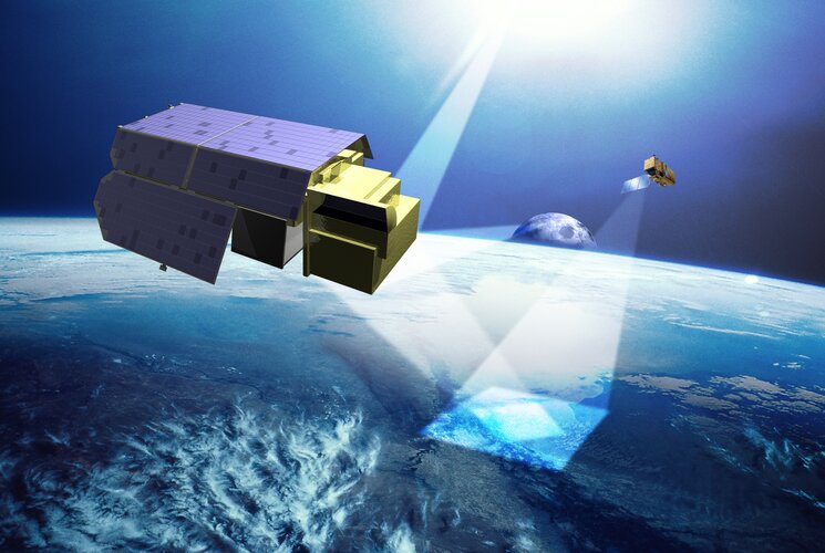
ESA’s new TRUTHS mission is taking shape. Highlighted today at COP26, this new mission is moving from its feasibility phase into its preliminary design phase. TRUTHS is set to provide measurements of incoming solar radiation and of radiation reflected from Earth back out into space as traceable International System of Units. These measurements will allow changes in Earth’s climate to be detected faster, and they will be used to calibrate data from other satellites. In effect, TRUTHS will be a ‘standards laboratory in space’, setting the ‘gold standard’ for climate measurements.
rada / odborný rada v oddělení obnovy katastrálního operátu
3.11.2021 15:08 ČÚZK - předpisy a opatření Katastrální úřad pro Pardubický kraj odbor obnovy katastrálního operátuvypisuje výběrové řízení na místo
rada / odborný rada v oddělení obnovy katastrálního operátu
rada / odborný rada v oddělení obnovy katastrálního operátu
3.11.2021 15:08 ČÚZK /Urady/Katastralni-urady/Katastralni-urady/Katastralni-urad-pro-Pardubicky-kraj/Uredni-deska/Oznameni-a-jina-uredni-sdeleni/Volna-mista/DMS/rada-odborny-rada-v-oddeleni-obnovy-katastralnihrada / odborný rada v oddělení obnovy katastrálního operátu
3.11.2021 15:08 ČÚZK - volná místa Katastrální úřad pro Pardubický kraj odbor obnovy katastrálního operátu vypisuje výběrové řízení na místo rada / odborný rada v oddělení obnovy katastrálního operátuOznámení o přerušení dodávky elektrické energie 16.11. 2021 od 9:00 do 16:00 hod.
3.11.2021 14:54 ČÚZK /Urady/Katastralni-urady/Katastralni-urady/Katastralni-urad-pro-Liberecky-kraj/Katastralni-pracoviste/KP-Semily/O-uradu/Aktuality/Oznameni-o-preruseni-dodavky-elektricke-energie-16Oznámení o přerušení dodávky elektrické energie 16.11. 2021 od 9:00 do 16:00 hod.
3.11.2021 14:54 ČÚZK - předpisy a opatření Katastrální úřad pro Liberecký kraj - Katastrální pracoviště Semily zveřejnil novou aktualitu: Katastrální úřad pro Liberecký krajKatastrální pracoviště SEMILY
Na základě oznámení ČEZ Distribuce, a. s. sdělujeme, že v úterý, 16. 11. 2021, bude přerušena dodávka elektrické energie, a to od 9:00 do 16:00 h.
Z uvedeného důvodu bude na KP Semily zabezpečen pouze provoz podatelny pro příjem listinných podání, a to jen do 12:00 h.
Děkujeme za pochopení.
ředitel katastrálního úřadu
Ing. Jiří Bekr
V Semilech dne 5. 11. 2021
Oznámení o přerušení dodávky elektrické energie 16.11. 2021 od 9:00 do 16:00 hod.
3.11.2021 14:54 ČÚZK - předpisy a opatření Katastrální úřad pro Liberecký kraj - Katastrální pracoviště Semily zveřejnil novou aktualitu: Katastrální úřad pro Liberecký krajKatastrální pracoviště SEMILY
Na základě oznámení ČEZ Distribuce, a. s. sdělujeme, že v úterý, 16. 11. 2021, bude přerušena dodávka elektrické energie, a to od 9:00 do 16:00 h.
Z uvedeného důvodu bude na KP Semily zabezpečen pouze provoz podatelny pro příjem listinných podání.
Děkujeme za pochopení.
ředitel katastrálního úřadu
Ing. Jiří Bekr
V Semilech dne 3. 11. 2021
EUSPA landed in Madrid for World ATM Congress to highlight environmental benefits of EU Space technology to aviation
3.11.2021 14:08 European GNSS Agency
World ATM Congress, the world’s largest international air traffic management (ATM) exhibition and conference, is always the place to be for EUSPA. Aviation experts and market development professionals were present to voice the importance of the EU Space Programme in aviation and its contribution to making the industry more sustainable. Drone demos by #MyGalileoDrone winners took place at Cuatro Vientos Airport.
Greener air travel and cost-efficient flight operations were a trending topic at World ATM Congress 2021. Aviation is one of the fastest-growing sources of greenhouse gas emissions. In particular, the aviation sector creates 13.9% of the emissions from transport, making it the second-biggest source of transport greenhouse gas emissions after road transport. In line with the EU Green Deal and to put a lid on aviation emissions, the European Union is placing a great emphasis on space technology. EUSPA aviation expert, Katerina Strelcova, explained how EU space technology contributes to safe and green aviation during a dedicated session.
For greener aviation, #EUspace is essential
Satellite-based landing is becoming the preferred technology for airlines that wish to optimise their routes and fuel consumption. EGNOS allows planes to make flexible approaches towards European airports and therefore shorten the flight path. Thanks to this flexibility, airlines can save up fuel and reduce noise above densely populated areas.
By enabling aircraft to land safely under challenging weather conditions such as fog, EGNOS helps reduce the frequency of aborted landings and emissions. An estimated 20.000 diversions will be avoided EU-wide thanks to EGNOS by 2025.
Copernicus contributes significantly to monitoring the environmental footprint of aviation through the Atmosphere Monitoring Service (CAMS). This service provides consistent and quality-controlled information about air pollution, greenhouse gases, and climate forcing.
Copernicus data is used to measure and monitor aircraft emissions that can enable to reduce climate impact, especially from contrail formation.
Moreover, atmospheric data from Copernicus delivers accurate information about atmospheric conditions that affect aviation, for example, the presence of dust or other particles which may degrade engines. When the data are further combined with AI, it can contribute to analytics for increased efficiency in managing aviation fleets and enhanced data for maintenance purposes. This Copernicus data can bring real added value to the industry.
Safety and accessibility are always a priority
In Europe, more than 400 airports use EGNOS, and the trend is on the rise. The provision of EGNOS approaches offers an alternative to airports not equipped with conventional navigation aids. It increases aviation safety and airport accessibility, especially in remote regions. Accessible airports equal more commercial opportunities for airlines and new flight routes at a regional and international level, with minimum costs for ground infrastructure and its maintenance.
Volcano eruptions -like the recent Cumbre Vieja Spain- significantly disrupt flight traffic, forcing pilots to take longer routes. Volcanic ash ejected into the atmosphere by explosive eruptions has known damaging effects on the aircraft fuselage. The CAMS generate atmosphere analyses to help assess the number of dust & particles which can affect the engine performance.
Read this: EGNOS Safety of Life: Serving aviation for 10 years
Drones and EGNSS go hand in hand
The drone market is booming and is set to outstrip any other GNSS user base in aviation. It is also opening up new business opportunities for application developers in many market segments. According to estimations, revenues from drone-based services are expected to exceed 150 million euros by 2023.
Unmanned Aerial Vehicles (UAV) have gained tremendous interest and have opened new possibilities in many areas ranging from mapping and surveying, to shipments delivery to even emergency response.
GNSS is not an option for drones anymore but a necessary asset. GNSS is essential for safe drone navigation, and GNSS receivers are now integrated on almost all new commercial drones as a standard feature. Given the additional accuracy Galileo offers, the EU GNSS is already present in more than 30% of the receivers used for drone applications, and many of them also implement EGNOS corrections to increase accuracy.
Media note: This feature can be republished without charge provided the European Union Agency for the Space Programme (EUSPA) is acknowledged as the source at the top or the bottom of the story. You must request permission before you use any of the photographs on the site. If you republish, we would be grateful if you could link back to the EUSPA website (http://www.euspa.europa.eu).
EUSPA landed in Madrid for World ATM Congress to highlight environmental benefits of EU Space technology to aviation
3.11.2021 14:08 European GNSS AgencyWorld ATM Congress, the world’s largest international air traffic management (ATM) exhibition and conference, is always the place to be for EUSPA. Aviation experts and market development professionals were present to voice the importance of the EU Space Programme in aviation and its contribution to making the industry more sustainable. Drone demos by #MyGalileoDrone winners took place at Cuatro Vientos Airport.
Greener air travel and cost-efficient flight operations were a trending topic at World ATM Congress 2021. Aviation is one of the fastest-growing sources of greenhouse gas emissions. In particular, the aviation sector creates 13.9% of the emissions from transport, making it the second-biggest source of transport greenhouse gas emissions after road transport. In line with the EU Green Deal and to put a lid on aviation emissions, the European Union is placing a great emphasis on space technology. EUSPA aviation expert, Katerina Strelcova, explained how EU space technology contributes to safe and green aviation during a dedicated session.
For greener aviation, #EUspace is essential
Satellite-based landing is becoming the preferred technology for airlines that wish to optimise their routes and fuel consumption. EGNOS allows planes to make flexible approaches towards European airports and therefore shorten the flight path. Thanks to this flexibility, airlines can save up fuel and reduce noise above densely populated areas.
By enabling aircraft to land safely under challenging weather conditions such as fog, EGNOS helps reduce the frequency of aborted landings and emissions. An estimated 20.000 diversions will be avoided EU-wide thanks to EGNOS by 2025.
Copernicus contributes significantly to monitoring the environmental footprint of aviation through the Atmosphere Monitoring Service (CAMS). This service provides consistent and quality-controlled information about air pollution, greenhouse gases, and climate forcing.
Copernicus data is used to measure and monitor aircraft emissions that can enable to reduce climate impact, especially from contrail formation.
Moreover, atmospheric data from Copernicus delivers accurate information about atmospheric conditions that affect aviation, for example, the presence of dust or other particles which may degrade engines. When the data are further combined with AI, it can contribute to analytics for increased efficiency in managing aviation fleets and enhanced data for maintenance purposes. This Copernicus data can bring real added value to the industry.
Safety and accessibility are always a priority
In Europe, more than 400 airports use EGNOS, and the trend is on the rise. The provision of EGNOS approaches offers an alternative to airports not equipped with conventional navigation aids. It increases aviation safety and airport accessibility, especially in remote regions. Accessible airports equal more commercial opportunities for airlines and new flight routes at a regional and international level, with minimum costs for ground infrastructure and its maintenance.
Volcano eruptions -like the recent Cumbre Vieja Spain- significantly disrupt flight traffic, forcing pilots to take longer routes. Volcanic ash ejected into the atmosphere by explosive eruptions has known damaging effects on the aircraft fuselage. The CAMS generate atmosphere analyses to help assess the number of dust & particles which can affect the engine performance.
Read this: EGNOS Safety of Life: Serving aviation for 10 years
Drones and EGNSS go hand in hand
The drone market is booming and is set to outstrip any other GNSS user base in aviation. It is also opening up new business opportunities for application developers in many market segments. According to estimations, revenues from drone-based services are expected to exceed 150 million euros by 2023.
Unmanned Aerial Vehicles (UAV) have gained tremendous interest and have opened new possibilities in many areas ranging from mapping and surveying, to shipments delivery to even emergency response.
GNSS is not an option for drones anymore but a necessary asset. GNSS is essential for safe drone navigation, and GNSS receivers are now integrated on almost all new commercial drones as a standard feature. Given the additional accuracy Galileo offers, the EU GNSS is already present in more than 30% of the receivers used for drone applications, and many of them also implement EGNOS corrections to increase accuracy.
Media note: This feature can be republished without charge provided the European Union Agency for the Space Programme (EUSPA) is acknowledged as the source at the top or the bottom of the story. You must request permission before you use any of the photographs on the site. If you republish, we would be grateful if you could link back to the EUSPA website (http://www.euspa.europa.eu).
Dne 5.11.2021 dojde na ČÚZK ke
3.11.2021 14:06 GEUSware Dne 5.11.2021 dojde na ČÚZK ke změnám webových služeb WSGP a WSDP a také ke změně ve struktuře výměnného formátu ISKN. WSGP bude podporována jen ve verzích 2.8 a 2.9, WSDP pouze ve verzi 2.9. Pokud budete chtít i nadále používat v GEUSu funkce Podklady měření - WSGP... nebo Odesílání GP - WSGP...., je potřeba mít GEUS 25.0 (nejméně verzi 25.0.5.323). Ve starších verzích programu tyto funkce již nebudou funkční. Změna ve struktuře VFK na verzi 5.6 nemá vliv na funkce v GEUSu a i stávající sestavení budou s touto verzí VFK nadále pracovat bez problémů.vrchní referent / rada v oddělení dokumentace KP Jičín
3.11.2021 13:53 ČÚZK - volná místa Katastrální úřad pro Královéhradecký kraj Katastrální pracoviště Jičín vypisuje výběrové řízení na místo vrchní referent / rada v oddělení dokumentace KP Jičínvrchní referent / rada v oddělení dokumentace KP Jičín
3.11.2021 13:53 ČÚZK - předpisy a opatření Katastrální úřad pro Královéhradecký kraj Katastrální pracoviště Jičínvypisuje výběrové řízení na místo
vrchní referent / rada v oddělení dokumentace KP Jičín
vrchní referent / rada v oddělení dokumentace KP Jičín
3.11.2021 13:53 ČÚZK /Urady/Katastralni-urady/Katastralni-urady/Katastralni-urad-pro-Kralovehradecky-kraj/Uredni-deska/Oznameni-a-jina-uredni-sdeleni/Volna-mista/DMS/vrchni-referent-rada-v-oddeleni-dokumentace-KP-JPrvní den Konference GIS Esri v ČR 2021
3.11.2021 13:26 ARCDATAKonference GIS Esri v ČR začala ve středu 3. listopadu blokem živých přednášek. Na začátku přivítal účastníky ředitel ARCDATA PRAHA Ing. Petr Seidl, CSc., a ve svém příspěvku se zabýval nejen významem geografických informačních systémů, ale ohlédl se i po třicetileté historii využívání GIS Esri v České republice. Ocenil také výroční cenou Magistrát města Brna za komplexní nasazení technologií ArcGIS.

Po něm se ujal slova ředitel Národního úřadu pro kybernetickou a informační bezpečnost brig. gen. Ing. Karel Řehka s přednáškou o kybernetické bezpečnosti ČR. Následoval politolog doc. PhDr. Tomáš Lebeda, Ph.D., který se zaměřil na analýzu letošních parlamentních voleb – i s využitím geoinformačních technologií.

S videopříspěvkem se hlavního programu zúčastnil prezident společnosti Esri Jack Dangermond, který promluvil o vzrůstající nutnosti starat se o naše životní prostředí. Na něj pak navázal doc. Ing. Jan Kolář, CSc., s přednáškou o ceně kosmických letů.
Během hlavního bloku jsme se mohli prostřednictvím dalších videopříspěvků seznámit i s podrobnostmi o nasazení GIS v Agentuře ochrany přírody a krajiny ČR, Lovochemii a.s., na Magistrátu města Brna a v Institutu plánování a rozvoje hl. m. Prahy.

Odpolední blok se věnoval konkrétním tématům z oblasti veřejné správy. Přednášky se tak týkaly portálu otevřených dat data.brno.cz, digitálních územně analytických podkladů v Praze a práce Městského ateliéru prostorového plánování a architektury Ostrava. Zakončení celého dne přednášek pak patřilo diskuzi nad tématem 30 let GIS Esri v ČR, které se zúčastnili Ing. Petr Seidl, CSc., doc. Jan Kolář, CSc., Mgr. Jiří Čtyroký, Ph.D., a Ing. Karel Brázdil, CSc.

Ve čtvrtek bude program pokračovat dopoledním blokem o novinkách a zajímavostech v systému ArcGIS a odpolední sekcí zaměřenou na správu inženýrských sítí. Během celé konferenci si účastníci (kterých je letos přihlášeno 1130) mohou ze záznamu pustit některou ze sedmnácti předtočených přednášek a prohlédnout si dvacítku map, portálů a webových aplikací.
Pokud jste zahájení konference nestihli, můžete si jeho záznam pustit na YouTube kanálu ARCDATA PRAHA.

Open data
3.11.2021 13:15
ÚGKK SR
Dnes na pôde úradu prebehlo rokovanie so zástupcami MIRRI a Slovensko.Digital o postupnom otváraní dát z ÚGKK SR.
ESA and GHGSat support new International Methane Emissions Observatory
3.11.2021 12:32 ESA Observing the Earth
In the first 20 years of reaching the atmosphere, methane has more than 80 times the warming power of carbon dioxide. Reducing emissions of this extremely potent gas is, therefore, one of the fastest ways of slowing the rate of global warming, at least in the short term – and at COP26, more than 100 countries have just signed up to the Global Methane Pledge, which aims to limit emissions by 30% compared with 2020 levels.
With both public and commercial satellite data playing key roles in assessing progress on climate action, ESA and GHGSat are supporting the United Nations Environment Programme’s new International Methane Emissions Observatory, also announced at COP26.
20211103_Ředitel sekce Katastrálního pracoviště Praha východ – odborný rada
3.11.2021 10:42 ČÚZK /Urady/Katastralni-urady/Katastralni-urady/Katastralni-urad-pro-Stredocesky-kraj/Katastralni-pracoviste/KP-Praha-vychod/O-uradu/Aktuality/20210113_odborny-rada,-reditel-Katastralniho-(2)20211103_Ředitel sekce Katastrálního pracoviště Praha východ – odborný rada
3.11.2021 10:42 ČÚZK - předpisy a opatření Katastrální úřad pro Středočeský kraj - Katastrální pracoviště Praha-východ Vyhlášení výběrového řízení: Ředitel sekce Katastrálního pracoviště Praha východ – odborný rada V části "Úřední deska", v sekci "Oznámení a jiná úřední sdělení" bylo vystaveno "Oznámení o vyhlášení výběrového řízení na obsazení systemizovaného místa Ředitel sekce Katastrálního pracoviště Praha východ – odborný rada"20211103_Ředitel sekce Katastrálního pracoviště Praha východ – odborný rada
3.11.2021 10:42 ČÚZK - předpisy a opatření Katastrální úřad pro Středočeský kraj - Katastrální pracoviště Praha-východ Vyhlášení výběrového řízení: Ředitel sekce Katastrálního pracoviště Praha východ – odborný rada V části "Úřední deska", v sekci "Oznámení a jiná úřední sdělení" bylo vystaveno "Oznámení o vyhlášení výběrového řízení na obsazení služebního místa Ředitel sekce Katastrálního pracoviště Praha východ – odborný rada"Ředitel sekce Katastrálního pracoviště Praha východ – odborný rada
3.11.2021 10:38 ČÚZK - volná místa Katastrální úřad pro Středočeský kraj - Katastrální pracoviště Praha-východ vypisuje výběrové řízení na místo Ředitel sekce Katastrálního pracoviště Praha východ – odborný radaŘeditel sekce Katastrálního pracoviště Praha východ – odborný rada
3.11.2021 10:38 ČÚZK /Urady/Katastralni-urady/Katastralni-urady/Katastralni-urad-pro-Stredocesky-kraj/Uredni-deska/Oznameni-a-jina-uredni-sdeleni/Volna-mista/Reditel-sekce-Katastralniho-pracoviste-Praha-vychoŘeditel sekce Katastrálního pracoviště Praha východ – odborný rada
3.11.2021 10:38 ČÚZK - předpisy a opatření Katastrální úřad pro Středočeský kraj - Katastrální pracoviště Praha-východvypisuje výběrové řízení na místo Ředitel sekce Katastrálního pracoviště Praha východ – odborný rada
Ředitel sekce Katastrálního pracoviště Praha východ – odborný rada
specializované činnosti v oddělení aktualizace katastru nemovitostí
3.11.2021 10:35 ČÚZK - předpisy a opatření Katastrální úřad pro Pardubický kraj Katastrální pracoviště Chrudimvypisuje výběrové řízení na místo
specializované činnosti v oddělení aktualizace katastru nemovitostí
specializované činnosti v oddělení aktualizace katastru nemovitostí
3.11.2021 10:35 ČÚZK - volná místa Katastrální úřad pro Pardubický kraj Katastrální pracoviště Chrudim vypisuje výběrové řízení na místo specializované činnosti v oddělení aktualizace katastru nemovitostíspecializované činnosti v oddělení aktualizace katastru nemovitostí
3.11.2021 10:35 ČÚZK /Urady/Katastralni-urady/Katastralni-urady/Katastralni-urad-pro-Pardubicky-kraj/Uredni-deska/Oznameni-a-jina-uredni-sdeleni/Volna-mista/DMS/specializovane-cinnosti-v-oddeleni-aktualizace-katMeltwater runoff from Greenland becoming more erratic
3.11.2021 10:16 ESA Observing the Earth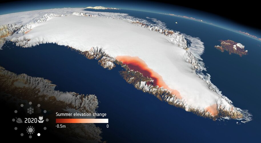
As world leaders and decision-makers join forces at COP26 to accelerate action towards the goals of the Paris Agreement, new research, again, highlights the value of satellite data in understanding and monitoring climate change. This particular new research, which is based on measurements from ESA’s CryoSat mission, shows that extreme ice melting events in Greenland have become more frequent and more intense over the past 40 years, raising sea levels and the risk of flooding worldwide.
20211103_Ředitel technické sekce – odborný rada
3.11.2021 9:58 ČÚZK /Urady/Katastralni-urady/Katastralni-urady/Katastralni-urad-pro-Stredocesky-kraj/O-uradu/Aktuality/20210113_odborny-rada,-reditel-Katastralniho-(2)20211103_Ředitel technické sekce – odborný rada
3.11.2021 9:58 ČÚZK - předpisy a opatření Katastrální úřad pro Středočeský kraj Vyhlášení výběrového řízení: Ředitel technické sekce – odborný rada V části "Úřední deska", v sekci "Oznámení a jiná úřední sdělení" bylo vystaveno "Oznámení o vyhlášení výběrového řízení na obsazení systemizovaného místa Ředitel technické sekce – odborný rada"20211103_Ředitel technické sekce – odborný rada
3.11.2021 9:58 ČÚZK - předpisy a opatření Katastrální úřad pro Středočeský kraj Vyhlášení výběrového řízení: Ředitel technické sekce – odborný rada V části "Úřední deska", v sekci "Oznámení a jiná úřední sdělení" bylo vystaveno "Oznámení o vyhlášení výběrového řízení na obsazení systemizovaného místa Rada / odborný rada – interní auditor Katastrálního úřadu pro Středočeský kraj"Ředitel technické sekce – odborný rada
3.11.2021 9:57 ČÚZK - předpisy a opatření Katastrální úřad pro Středočeský kraj - technická sekcevypisuje výběrové řízení na místo Ředitel technické sekce – odborný rada
Ředitel technické sekce – odborný rada
Ředitel technické sekce – odborný rada
3.11.2021 9:57 ČÚZK - volná místa Katastrální úřad pro Středočeský kraj - technická sekce vypisuje výběrové řízení na místo Ředitel technické sekce – odborný radaŘeditel technické sekce – odborný rada
3.11.2021 9:57 ČÚZK /Urady/Katastralni-urady/Katastralni-urady/Katastralni-urad-pro-Stredocesky-kraj/Uredni-deska/Oznameni-a-jina-uredni-sdeleni/Volna-mista/Reditel-technicke-sekce-–-odborny-radaKaman Reports 2021 Third Quarter Results
3.11.2021 0:53 GISCafe.com Webcasts-Webinars Third Quarter Highlights:Kaman revises full year outlook for 2021; higher earnings from continuing operations on lower sales, cash flow guidance …
Juniorstar grant pro dr. Hrbáčka
3.11.2021 0:00 Geografický ústav MUS velkým potěšením oznamujeme úspěch dr. Filipa Hrbáčka, který získal v soutěži GAČR prestižní Juniorstar grant na dobu pěti let https://gacr.cz/prestizni-granty-junior-star-ziska-16-zacinajicich-vedcu/.
Gratulujeme!
Článek Petra Jehličky v časopise Progress in Human Geography
3.11.2021 0:00 Geografický ústav MUPetr Jehlička, který na GÚ pracuje v týmu „Prostory tiché udržitelnosti“, publikoval v posledním čísle Progress in Human Geography článek „Eastern Europe and the geography of knowledge production: The case of the invisible gardener“, ve kterém kritizuje marginalizaci vědění, vytvářeného v našem geopolitickém regionu. Jde pravděpodobně o první článek českého autora v tomto prestižním časopise, který mapuje vývoj současné sociální geografie a nastavuje trendy jejího vývoje.
Článek je k dispozici zde: https://journals.sagepub.com/doi/full/10.1177/0309132520987305
Juniorstar grant pro dr. Filipa Hrbáčka
3.11.2021 0:00 Geografický ústav MUS velkým potěšením oznamujeme úspěch dr. Filipa Hrbáčka, který získal v soutěži GAČR prestižní Juniorstar grant na dobu pěti let https://gacr.cz/prestizni-granty-junior-star-ziska-16-zacinajicich-vedcu/.
Gratulujeme!
The need for more data advisors in the buildings sector
2.11.2021 18:55 Bentley SystemsPressCoverage
Infrastructure Intelligence, UK
Read the articleDedrone Announces Successful Citywide Airspace Security Deployment
2.11.2021 17:38 GISCafe.com Webcasts-Webinars Enabling major European city’s public safety and law enforcement officials to protect their citizens and infrastructure from airborne threatsSAN …
Local Motors Selects Ouster Lidar for Production of Its Next-Generation Autonomous Shuttles
2.11.2021 17:37 GISCafe.com Webcasts-Webinars Ouster to deliver thousands of digital lidar sensors to Local Motors through 2025SAN FRANCISCO — (BUSINESS WIRE) — November 2, 2021 …
Maptelligent, Inc., is Pleased to Announce a Partnership with Michael Quan with the Interactive Tactical Group
2.11.2021 17:37 GISCafe.com Webcasts-Webinars LAS VEGAS, NV, Nov. 02, 2021 (GLOBE NEWSWIRE) -- via NewMediaWire – Maptelligent, Inc. (OTC PK: MAPT), www.maptelligent.com. Maptelligent’s …US Annual Home Price Growth Hits 18% in September as Supply and Demand Imbalances Intensify, CoreLogic Reports
2.11.2021 17:37 GISCafe.com Webcasts-Webinars Tech hubs across the U.S. and the Western region continue to lead the way in price growthSupply and demand pressures converge, creating barriers …
ModalAI Releases New Seeker Micro-Development Drone and VOXL CAM Perception Engine that Powers Smaller Drones, Robots and IoT Devices
2.11.2021 17:37 GISCafe.com Webcasts-Webinars World’s First Micro-Development Drone, ModalAI Seeker, Provides Autonomous Navigation Indoor and OutdoorSAN DIEGO — (BUSINESS WIRE) — …
BlackSky Appoints Amy Minnick as Chief Commercial Officer
2.11.2021 17:37 GISCafe.com Webcasts-Webinars Geospatial and analytics industry leader will focus on driving growthHERNDON, Va. — (BUSINESS WIRE) — November 2, 2021 —
BlackSky …
Bell and Esri Canada deliver Integrated Smart City Ecosystem to empower Canadian communities of all sizes
2.11.2021 17:37 GISCafe.com Webcasts-Webinars MONTRÉAL, Nov. 2, 2021 — (PRNewswire) —Combining Bell's 5G network and Internet of Things leadership with Esri's real-time analytics …
Viasat and AEVEX Aerospace Help the U.S. Forest Service and the Orange County, California Fire Authority Fight Dangerous Fires using Satellite Communications and Infrared Mapping
2.11.2021 17:37 GISCafe.com Webcasts-Webinars CARLSBAD and SOLANA BEACH, Calif., Nov. 2, 2021 — (PRNewswire) — Viasat Inc. (NASDAQ: VSAT), a global communications company, and …Axon and Fotokite Bring Actively Tethered Autonomous Drones with Livestreaming and Evidence Management to Public Safety Today
2.11.2021 17:37 GISCafe.com Webcasts-Webinars Fotokite is the world's only drone permitted by the FAA to be operated by public safety team members without a pilot licenseSCOTTSDALE, Ariz., Nov. …
Nová aplikace ContractSupport
2.11.2021 16:57 Hrdlička Smlouvy, dokumenty a návrhy na vklad do katastru lusknutím prstu.ContractSupport - nová aplikace
2.11.2021 16:40 Hrdlička Smlouvy, dokumenty a návrhy na vklad do katastru lusknutím prstu.Space for a Green Future
2.11.2021 15:06 ESA Observing the Earth Video:
00:02:12
Video:
00:02:12
The climate crisis is the most urgent challenge faced by humankind – affecting every region, continent, and ocean on Earth. Space has an untapped potential to make a difference in tackling the threats and challenges faced by humanity. Satellites watch over Earth continuously, helping us to monitor, understand, model, predict and act on climate change and its related challenges.
As part of one of the three ‘Accelerators’ that will drive Europe’s increased use of space, the Space for a Green Future Accelerator will help Europe act to mitigate climate change. It will provide actionable information, helping form the baseline for effective European adaptation strategies to support the green transition, enabling the European Union to reach its goal of becoming carbon neutral by 2050, and supporting its Green Deal. Learn more about how ESA will bring Europe’s space ambitions to the next level by clicking here.
2021102_Rada / odborný rada oddělení právních vztahů k nemovitostem
2.11.2021 10:44 ČÚZK /Urady/Katastralni-urady/Katastralni-urady/Katastralni-urad-pro-Stredocesky-kraj/Katastralni-pracoviste/KP-Rakovnik/O-uradu/Aktuality/20210922_Odborny-referent-oddeleni-aktualizace-(2)2021102_Rada / odborný rada oddělení právních vztahů k nemovitostem
2.11.2021 10:44 ČÚZK - předpisy a opatření Katastrální úřad pro Středočeský kraj - Katastrální pracoviště Rakovník Vyhlášení výběrového řízení: Rada / odborný rada oddělení právních vztahů k nemovitostem V části "Úřední deska", v sekci "Oznámení a jiná úřední sdělení" bylo vystaveno "Oznámení o vyhlášení výběrového řízení na obsazení služebního místa Rada / odborný rada oddělení právních vztahů k nemovitostem"Rada / odborný rada oddělení právních vztahů k nemovitostem
2.11.2021 10:44 ČÚZK - volná místa Katastrální úřad pro Středočeský kraj - Katastrální pracoviště Rakovník vypisuje výběrové řízení na místo Rada / odborný rada oddělení právních vztahů k nemovitostemRada / odborný rada oddělení právních vztahů k nemovitostem
2.11.2021 10:44 ČÚZK - předpisy a opatření Katastrální úřad pro Středočeský kraj - Katastrální pracoviště Rakovníkvypisuje výběrové řízení na místo Rada / odborný rada oddělení právních vztahů k nemovitostem
Rada / odborný rada oddělení právních vztahů k nemovitostem
Change in the Arctic
2.11.2021 10:00 ESA Observing the Earth Video:
00:03:17
Video:
00:03:17
Satellites play a vital role in monitoring the rapid changes taking place in the Arctic. Tracking ice lost from the world’s glaciers, ice sheets and frozen land shows that Earth is losing ice at an accelerating rate. Currently more than a trillion tonnes of ice is lost each year. The sooner Earth’s temperature is stabilised, the more manageable the impacts of ice loss will be.
obnova katastrálního operátu
2.11.2021 9:06 ČÚZK - volná místa Katastrální úřad pro Olomoucký kraj - technický odbor vypisuje výběrové řízení na místo obnova katastrálního operátuobnova katastrálního operátu
2.11.2021 9:06 ČÚZK - předpisy a opatření Katastrální úřad pro Olomoucký kraj - technický odborvypisuje výběrové řízení na místo
obnova katastrálního operátu
Uzavření Katastrálního pracoviště
2.11.2021 9:02 ČÚZK /Urady/Katastralni-urady/Katastralni-urady/Katastralni-urad-pro-Vysocinu/Katastralni-pracoviste/KP-Zdar-nad-Sazavou/O-uradu/Aktuality/Uzavreni-Katastralniho-pracovisteUzavření Katastrálního pracoviště
2.11.2021 9:02 ČÚZK - předpisy a opatření Katastrální úřad pro Vysočinu - Katastrální pracoviště Žďár nad Sázavou zveřejnil novou aktualitu: Katastrální úřad pro Vysočinu, Katastrální pracoviště Žďár nad Sázavou oznamuje, že ve dnech 3. a 4. 11. 2021 bude z technických důvodů uzavřena budova Katastrálního pracoviště Žďár nad Sázavou.Děkujeme za pochopení.
Jak pracovníci Pražské teplárenské provádějí kontroly šachet?
2.11.2021 8:59 Unicorn K tomu, aby mohla Pražská teplárenská dodávat teplo do pražských domácností, potřebuje mimo jiné i podzemní šachty. Ty je potřeba v pravidelných intervalech kontrolovat a revidovat. Významným pomocníkem je v tomto procesu mobilní GIS od Unicorn Systems.Webinář: ProGEO verze 21
2.11.2021 8:57 Unicorn V rámci webináře vám představíme nové ProGEO verze 21, jež obsahuje vylepšeného managera zakázek, nové Centrum fotografií, možnost provozu nad Bentley produkty řady Connect Edition a další novinky. Seznámíme Vás s nejen obchodními informacemi z Bentley a představíme výhodnou slevovou kampaň na licence z řady HSI a Bentley. Již tento čtvrtek 4. 11., budeme se na vás těšit.Rada vlády jmenovala nového koordinátora hodnocení vědy a výzkumu
2.11.2021 6:00 GeoBusinessVe středu 27. října 2021 se v pražské Strakově akademii uskutečnilo další z pravidelných zasedání Rady pro výzkum, vývoj a inovace (RVVI). K hlavním bodům jednání patřily Národní plán obnovy, Implementace Metodiky hodnocení 2017+ a výsledky mezinárodního hodnocení velkých výzkumných infrastruktur. V prvém bodu jednání k podpoře vědy a výzkumu z Národního plánu obnovy (NPO) se členové RVVI zabývali dvěma souvislými tématy – přípravou […]
The post Rada vlády jmenovala nového koordinátora hodnocení vědy a výzkumu appeared first on GeoBusiness.