


![]()

zprávy
zdroje zpráv:It’s the final countdown for #myEUspace! Ready to submit?
30.11.2021 11:57 European GNSS Agency
We have many countdowns to look forward to this week, the first being the Galileo Launch 11 taking place 24 hours just before the #myEUSpace deadline! To help you put a final touch on your projects/ideas, here are the nuts and bolts of the "Space my Life" and "Dive in Quantum" challenges.
The "Space my life" challenge looks to create consumer solutions such as mobile applications and services using space data for health, gaming, sports, leisure, tourism, and everyday life purposes. The ideas should be leveraging innovative features of EGNSS and Copernicus in the mobile apps and smart wearables domain, fusing non-space technologies like IoT, big data, artificial intelligence, drones, 5G, augmented/mixed reality, etc.
For example, Galileo’s capability to deliver precise, robust positioning and timing information, combined with IoT, can enhance our lives through interconnected devices. Another example of innovative applications in this area is the exploitation of Galileo’s differentiators – like the High Accuracy Service and the authentication features – of which mobile applications can benefits thanks to the availability of GNSS raw measurements in smartphones.
Previous solutions targeting mass markets were #MyGalileoSolution competition overall winner "Vision Anchor" and #ΜyGalileoSolution finalist "Bit Pet".
Dive in Quantum, yes that’s a tough one!
Quantum technologies use the properties of quantum effects – the interactions of molecules, atoms, and even smaller particles, known as quantum objects – to create practical applications in many different fields, and space applications are one of them.
Participants are tasked with coupling Copernicus and Galileo with quantum technologies such as quantum computing, sensing, simulation, encryption to enhance space downstream applications.
With high-speed connectivity, protected communications, and high computing power becoming essential, quantum technologies can address or help mitigate some of the biggest challenges of today’s digital challenges.
Applications addressing the "Dive in Quantum" innovation area shall be submitted only in Track 1. In Track 1, applicants will have to turn their theoretical idea into a prototype of their product, articulating their value proposition and exploring Problem-Solution Fit based on a validation test in a relevant environment. Projects are expected to reach at least TRL 4.
In Track 2 teams are asked to bring their prototype/beta version to a Minimum Viable Product (MVP), reach a functional stage and commercialization readiness and develop a value proposition to meet Product-Market Fit. Projects expected to reach at least TRL 9.
Time is running out but before submitting, remember to read again the Terms of References here. Good luck!
Media note: This feature can be republished without charge provided the European Union Agency for the Space Programme (EUSPA) is acknowledged as the source at the top or the bottom of the story. You must request permission before you use any of the photographs on the site. If you republish, we would be grateful if you could link back to the EUSPA website (http://www.euspa.europa.eu).
Vrchní referent/rada v oddělení aktualizace KN na Katastrálním pracovišti Vyškov
30.11.2021 10:42 ČÚZK - volná místa Katastrální úřad pro Jihomoravský kraj Katastrální pracoviště Vyškov vypisuje výběrové řízení na místo Vrchní referent/rada v oddělení aktualizace KN na Katastrálním pracovišti VyškovVrchní referent/rada v oddělení aktualizace KN na Katastrálním pracovišti Vyškov
30.11.2021 10:42 ČÚZK - předpisy a opatření Katastrální úřad pro Jihomoravský kraj Katastrální pracoviště Vyškovvypisuje výběrové řízení na místo
Vrchní referent/rada v oddělení aktualizace KN na Katastrálním pracovišti Vyškov
Vrchní referent/rada v oddělení aktualizace KN na Katastrálním pracovišti Vyškov
30.11.2021 10:42 ČÚZK /Urady/Katastralni-urady/Katastralni-urady/Katastralni-urad-pro-Jihomoravsky-kraj/Uredni-deska/Oznameni-a-jina-uredni-sdeleni/Volna-mista/DMS/Vrchni-referent-rada-v-oddeleni-aktualizace-KN-naOdborný referent v oddělení dokumentace KN na Katastrálním pracovišti Břeclav
30.11.2021 10:40 ČÚZK - volná místa Katastrální úřad pro Jihomoravský kraj vypisuje výběrové řízení na místo Odborný referent v oddělení dokumentace KN na Katastrálním pracovišti BřeclavOdborný referent v oddělení dokumentace KN na Katastrálním pracovišti Břeclav
30.11.2021 10:40 ČÚZK - předpisy a opatření Katastrální úřad pro Jihomoravský krajvypisuje výběrové řízení na místo
Odborný referent v oddělení dokumentace KN na Katastrálním pracovišti Břeclav
Odborný referent v oddělení dokumentace KN na Katastrálním pracovišti Břeclav
30.11.2021 10:40 ČÚZK /Urady/Katastralni-urady/Katastralni-urady/Katastralni-urad-pro-Jihomoravsky-kraj/Uredni-deska/Oznameni-a-jina-uredni-sdeleni/Volna-mista/DMS/Odborny-referent-v-oddeleni-dokumentace-KN-na-KataOznámení o vyhlášení výběrového řízení na služební místo odborný/vrchní referent – OOKO
30.11.2021 9:25 ČÚZK - předpisy a opatření Katastrální úřad pro Plzeňský kraj - Katastrální pracoviště Plzeň-město zveřejnil novou aktualitu: Oznámení o vyhlášení výběrového řízení na služební místo odborný/vrchní referent – obnova katastrálního operátu OKO1003 , oddělení aktualizace KN, Katastrální úřad pro Plzeňský kraj, Katastrální pracoviště Plzeň - městoOznámení o vyhlášení výběrového řízení na služební místo odborný/vrchní referent – OOKO
30.11.2021 9:25 ČÚZK - předpisy a opatření Katastrální úřad pro Plzeňský kraj - Katastrální pracoviště Plzeň-město zveřejnil novou aktualitu: Oznámení o vyhlášení výběrového řízení na služební místo odborný/vrchní referent – obnova katastrálního operátu OKO1003 , oddělení aktualizace KN, Katastrální úřad pro Plzeňský kraj, Katastrální pracoviště Plzeň - městoOznámení o vyhlášení výběrového řízení na služební místo odborný/vrchní referent – OOKO
30.11.2021 9:25 ČÚZK /Urady/Katastralni-urady/Katastralni-urady/Katastralni-urad-pro-Plzensky-kraj/O-uradu/Aktuality/Oznameni-o-vyhlaseni-vyberoveho-rizeni-na-sluz-(2)Oznámení o vyhlášení výběrového řízení na služební místo odborný/vrchní referent – obnova katastráln
30.11.2021 9:18 ČÚZK - volná místa Katastrální úřad pro Plzeňský kraj odbor obnovy katastrálního operátu vypisuje výběrové řízení na místo Oznámení o vyhlášení výběrového řízení na služební místo odborný/vrchní referent – obnova katastrálnOznámení o vyhlášení výběrového řízení na služební místo odborný/vrchní referent – obnova katastráln
30.11.2021 9:18 ČÚZK /Urady/Katastralni-urady/Katastralni-urady/Katastralni-urad-pro-Plzensky-kraj/Uredni-deska/Oznameni-a-jina-uredni-sdeleni/Volna-mista/DMS/Oznameni-o-vyhlaseni-vyberoveho-rizeni-na-sluz-(2)Oznámení o vyhlášení výběrového řízení na služební místo odborný/vrchní referent – obnova katastráln
30.11.2021 9:18 ČÚZK - předpisy a opatření Katastrální úřad pro Plzeňský kraj odbor obnovy katastrálního operátuvypisuje výběrové řízení na místo
Oznámení o vyhlášení výběrového řízení na služební místo odborný/vrchní referent – obnova katastrálního operátu OKO1003
Unleash live Achieves AWS Energy Competency With Real Time Video Analytics for Wind, Solar and Power Line Automated Inspections
30.11.2021 2:28 GISCafe.com Webcasts-Webinars SYDNEY — (BUSINESS WIRE) — November 29, 2021 —Unleash live, one of the world’s leading A.I. video analytics platforms, …
Amsterdam Drone Week - Highlights ADW Hybrid 18-20 January 2022
30.11.2021 1:08 GISCafe.com Webcasts-Webinars Amsterdam, 29 November 2021Highlights ADW Hybrid 18-20 January 2022Center of the international drone community
In January RAI Amsterdam will once …
First responders gain valuable insights from Applanix technology for rescue and damage assessment
30.11.2021 1:06 GISCafe.com Webcasts-Webinars Georeferenced aerial images and mapping captured by NOAA with sixth-generation Digital Sensor SystemRICHMOND HILL, CANADA, Nov. 25, …
Hexagon announces partnership with Airbus for near real-time airborne bathymetric LiDAR surveillance system
30.11.2021 0:45 GISCafe.com Webcasts-Webinars (Jönköping, Sweden, 18 November 2021) Hexagon’s Geosystems division announced today a partnership with Airbus to …Insights From One of the Speakers on The Largest UK’s Geospatial Event – Geo Business 2021
29.11.2021 22:31 GISCafe.com Webcasts-Webinars NAPLES, Fla., Nov. 29, 2021 (GLOBE NEWSWIRE) -- GEO Business 2021, the UK’s largest geospatial event designed for everyone involved in the …DATAMARK Announces Partnership with Critical Response Group (CRG) to Provide Intelligent Indoor Mapping Solutions to the Public Safety Community
29.11.2021 22:31 GISCafe.com Webcasts-Webinars Partnership combines on-site data verification with the intelligence of DATAMARK's GIS portfolio of productsSANTA ANA, Calif., Nov. 29, 2021 …
Odborný seminář ČKS: Kartovýročí 2021
29.11.2021 20:58 Česká kartografická společnost Dne 11. listopadu 2021 se uskutečnilo v prostorách Pedagogické knihovny J.A. Komenského v Praze podzimní setkání kartografů u českých školních atlasů, a to v rámci již několikátého odborného semináře v rámci tzv. kartovýročí. Akce navázala na semináře realizované v minulých letech (již od roku 2016, kdy proběhl seminář a výstava k výročí 300 let od vydání Müllerovy mapy Moravy). Letošní setkání se vyznačovalo poněkud odlišnou […]Australia Must Embrace Digital Twins to Make Cities Smarter
29.11.2021 19:40 Bentley SystemsPressCoverage
Sourceable, Australia
Read the articleHuawei's Petal Maps 2.0 adds "Lane Guidance" and "Offline Map" features to help users save time and explore the world safely
29.11.2021 17:25 GISCafe.com Webcasts-Webinars SINGAPORE, Nov. 29, 2021 — (PRNewswire) — Huawei's Petal Maps app today announced the launch of its version 2.0 update, adding a …Kratos Receives $4.1 Million Unmanned Aerial Vehicle System Award from International Customer
29.11.2021 17:25 GISCafe.com Webcasts-Webinars SAN DIEGO, Nov. 29, 2021 (GLOBE NEWSWIRE) -- Kratos Defense & Security Solutions, Inc. (Nasdaq: KTOS), a leading National Security Solutions …Airobotics Drones Enters the Malaria Eradication Market
29.11.2021 17:25 GISCafe.com Webcasts-Webinars Airobotics has joined the fight against Malaria and entered a new market, signing an initial contract with Zzapp Malaria to supply aerial data and …Sentinel-6 returning most precise data ever on sea level
29.11.2021 14:35 ESA Observing the Earth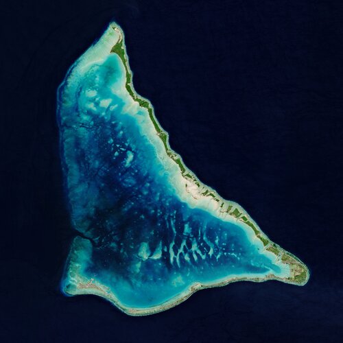
Sea-level rise is one of the most immediate consequences of climate change, as highlighted recently through urgent pleas from leaders of island nations at the COP26 summit. Global measures of sea-level rise are imperative to underpinning global policy and for strategies to protect coastlines and low-lying lands. Measuring tiny differences in the height of the sea surface from space is no easy task – but that’s exactly what the Copernicus Sentinel-6 Michael Freilich satellite is doing. And, after a year of exhaustive testing, this new mission is now delivering the world’s most accurate data on sea-level rise.
Oznámení o vyhlášení výběrového řízení na služební místo rada/odborný rada - vedoucí oddělení aktual
29.11.2021 13:09 ČÚZK /Urady/Katastralni-urady/Katastralni-urady/Katastralni-urad-pro-Plzensky-kraj/O-uradu/Aktuality/Oznameni-o-vyhlaseni-vyberoveho-rizeni-na-sluz-(1)Oznámení o vyhlášení výběrového řízení na služební místo rada/odborný rada - vedoucí oddělení aktual
29.11.2021 13:09 ČÚZK - předpisy a opatření Katastrální úřad pro Plzeňský kraj - Katastrální pracoviště Rokycany zveřejnil novou aktualitu: Oznámení o vyhlášení výběrového řízení na služební místo rada/odborný rada - vedoucí oddělení aktualizace a dokumentace KN-VOAD13,Katastrální úřad pro Plzeňský kraj, Katastrální pracoviště RokycanyOznámení o vyhlášení výběrového řízení na služební místo rada/odborný rada - vedoucí oddělení aktual
29.11.2021 13:03 ČÚZK /Urady/Katastralni-urady/Katastralni-urady/Katastralni-urad-pro-Plzensky-kraj/Uredni-deska/Oznameni-a-jina-uredni-sdeleni/Volna-mista/DMS/Oznameni-o-vyhlaseni-vyberoveho-rizeni-na-sluz-(1)Oznámení o vyhlášení výběrového řízení na služební místo rada/odborný rada - vedoucí oddělení aktual
29.11.2021 13:03 ČÚZK - předpisy a opatření Katastrální úřad pro Plzeňský kraj Katastrální pracoviště Rokycanyvypisuje výběrové řízení na místo
Oznámení o vyhlášení výběrového řízení na služební místo rada/odborný rada - vedoucí oddělení aktualizace a dokumentace KN-VOAD13 - Rokycany
Oznámení o vyhlášení výběrového řízení na služební místo rada/odborný rada - vedoucí oddělení aktual
29.11.2021 13:03 ČÚZK - volná místa Katastrální úřad pro Plzeňský kraj Katastrální pracoviště Rokycany vypisuje výběrové řízení na místo Oznámení o vyhlášení výběrového řízení na služební místo rada/odborný rada - vedoucí oddělení aktualJak pracovníci Pražské teplárenské provádějí kontroly šachet?
29.11.2021 12:45 Unicorn K tomu, aby mohla Pražská teplárenská dodávat teplo do pražských domácností, potřebuje mimo jiné i podzemní šachty. Ty je potřeba v pravidelných intervalech kontrolovat a revidovat. Významným pomocníkem je v tomto procesu mobilní GIS od Unicorn Systems.Jak pracovníci Pražské teplárenské provádějí kontroly šachet?
29.11.2021 12:45 Unicorn K tomu, aby mohla Pražská teplárenská dodávat teplo do pražských domácností, potřebuje mimo jiné i podzemní šachty. Ty je potřeba v pravidelných intervalech kontrolovat a revidovat. Významným pomocníkem je v tomto procesu mobilní GIS od Unicorn Systems.odborný/vrchní referent - personalista/ka v kanceláři ředitele Katastrálního úřadu pro Jihočeský kra
29.11.2021 11:43 ČÚZK /Urady/Katastralni-urady/Katastralni-urady/Katastralni-urad-pro-Jihocesky-kraj/Uredni-deska/Oznameni-a-jina-uredni-sdeleni/Volna-mista/DMS/odborny-vrchni-referent-personalista-ka-v-kancelodborný/vrchní referent - personalista/ka v kanceláři ředitele Katastrálního úřadu pro Jihočeský kra
29.11.2021 11:43 ČÚZK - předpisy a opatření Katastrální úřad pro Jihočeský kraj kancelář ředitelevypisuje výběrové řízení na místo
odborný/vrchní referent - personalista/ka v kanceláři ředitele Katastrálního úřadu pro Jihočeský kraj (ID SM 30000370/30094306)
odborný/vrchní referent - personalista/ka v kanceláři ředitele Katastrálního úřadu pro Jihočeský kra
29.11.2021 11:43 ČÚZK - volná místa Katastrální úřad pro Jihočeský kraj kancelář ředitele vypisuje výběrové řízení na místo odborný/vrchní referent - personalista/ka v kanceláři ředitele Katastrálního úřadu pro Jihočeský kraEUSPA makes first appearance at General Assembly of the Copernicus networks
29.11.2021 11:37 European GNSS Agency
The 5th General Assembly of the Copernicus Academy and Relays Networks, organized by the European Commission, was the opportunity to reflect on the 2021 Earth Observation milestones and build the future of the Copernicus networks together. The EU Agency for the Space Programme was present for the first time to present its new mission and highlight Copernicus flavored funding opportunities.
The two-day event, which took place on 23-24 November, gathered interesting European Commission policy experts, industry stakeholders, and Earth Observation enthusiasts. Distinguished panelists highlighted the importance of the new EU Space Programme policy framework and the potential synergies between the components can offer. Particular emphasis was placed on how Copernicus, in conjunction with Galileo and EGNOS, can contribute to current pressing challenges such as environmental compliance or ice retreat in polar regions.
For the first time after its extended mandate to support the promotion and commercialisation of the downstream Copernicus services, EUSPA participated in the General Assembly. Justyna Redelkiewicz, head of LBS at EUSPA Market Development, participated in the Session ‘’CASSINI: Moving forward with a more competitive EU Space Industry’’ where she presented the revisited mission of the agency as well new funding opportunities that now also include Copernicus. Redelkiewicz highlighted that the Horizon Europe calls are designed to boost synergies between the EU Space Programme components and blend well with the EU Green Deal. She also sent a reminder to #myEUspace applicants about the December 2nd submission deadline before giving a hint about the upcoming EUSPA Market Report, as it will include Copernicus insights.
New Space and Copernicus is the real deal!
Interest was sparked during the ''New Space & Copernicus: How can they best cooperate?'' session. European Commission experts pointed out, that relationship between the EU Earth Observation Programme and New Space companies is mutually beneficial. Copernicus offers a vast amount of geospatial data that help them step up their business operations. At the same time, Copernicus can benefit from quality input such as very high-resolution imagery from new space companies in Europe.
Guest speakers during this session included ICEYE, a Finnish global leader in small satellite synthetic-aperture radar (SAR) technology. The company recently became the first European New Space company to provide data to the Copernicus Contributing Missions. Copernicus services will now receive access to ICEYE’s SAR imagery and use it to enhance public safety, border control, security, and maritime domain awareness. Other New space companies included ScanWorld and Auroratech, both of which rely on Sentinel data for vegetation analysis and wildfire detection, respectively.
Read this: Unlocking Africa’s full EO potential with EU Space synergies
#EUSpace is truly global
The EU space economy is the second-largest - in the world- supported by flagship space assets Galileo, EGNOS, and Copernicus. It is estimated to have generated over 250,000 jobs, with over 50,000 in the downstream sector. The edition of the 2021 General Assemblies was the opportunity to tap on this and present the newly established initiative of DG DEFIS called ‘’EU GLOBAL ACTION on Space’’ aimed at deepening existing and forging new business opportunities with targeted third countries across the globe. Copernicus network members can patriciate in or benefit from webinars and events organized by Global action.
‘’Propagating information about Copernicus's potential and preparing new generations of professionals to use space applications is fundamental for a successful European Space policy. In this respect, the Assembly of Copernicus Academy and Relays Networks has an important role and will also benefit from the extended mandate that EUSPA has gained in the New Space Programme” The Generally Assembly meeting is now renewed for 2022 and EUSPA looks forward to it,’’ says Mauro Facchini, Head of the Copernicus Unit at DG DEFIS.
Media note: This feature can be republished without charge provided the European Union Agency for the Space Programme (EUSPA) is acknowledged as the source at the top or the bottom of the story. You must request permission before you use any of the photographs on the site. If you republish, we would be grateful if you could link back to the EUSPA website (http://www.euspa.europa.eu).
EUSPA makes first appearance at General Assembly of the Copernicus networks
29.11.2021 11:37 European GNSS AgencyThe 5th General Assembly of the Copernicus Academy and Relays Networks, organized by the European Commission, was the opportunity to reflect on the 2021 Earth Observation milestones and build the future of the Copernicus networks together. The EU Agency for the Space Programme was present for the first time to present its new mission and highlight Copernicus flavored funding opportunities.
The two-day event, which took place on 23-24 November, gathered interesting European Commission policy experts, industry stakeholders, and Earth Observation enthusiasts. Distinguished panelists highlighted the importance of the new EU Space Programme policy framework and the potential synergies between the components can offer. Particular emphasis was placed on how Copernicus, in conjunction with Galileo and EGNOS, can contribute to current pressing challenges such as environmental compliance or ice retreat in polar regions.
For the first time after its extended mandate to support the promotion and commercialisation of the downstream Copernicus services, EUSPA participated in the General Assembly. Justyna Redelkiewicz, head of LBS at EUSPA Market Development, participated in the Session ‘’CASSINI: Moving forward with a more competitive EU Space Industry’’ where she presented the revisited mission of the agency as well new funding opportunities that now also include Copernicus. Redelkiewicz highlighted that the Horizon Europe calls are designed to boost synergies between the EU Space Programme components and blend well with the EU Green Deal. She also sent a reminder to #myEUspace applicants about the December 3rd submission deadline before giving a hint about the upcoming EUSPA Market Report, as it will include Copernicus insights.
New Space and Copernicus is the real deal!
Interest was sparked during the ''New Space & Copernicus: How can they best cooperate?'' session. European Commission experts pointed out, that relationship between the EU Earth Observation Programme and New Space companies is mutually beneficial. Copernicus offers a vast amount of geospatial data that help them step up their business operations. At the same time, Copernicus can benefit from quality input such as very high-resolution imagery from new space companies in Europe.
Guest speakers during this session included ICEYE, a Finnish global leader in small satellite synthetic-aperture radar (SAR) technology. The company recently became the first European New Space company to provide data to the Copernicus Contributing Missions. Copernicus services will now receive access to ICEYE’s SAR imagery and use it to enhance public safety, border control, security, and maritime domain awareness. Other New space companies included ScanWorld and Auroratech, both of which rely on Sentinel data for vegetation analysis and wildfire detection, respectively.
Read this: Unlocking Africa’s full EO potential with EU Space synergies
#EUSpace is truly global
The EU space economy is the second-largest - in the world- supported by flagship space assets Galileo, EGNOS, and Copernicus. It is estimated to have generated over 250,000 jobs, with over 50,000 in the downstream sector. The edition of the 2021 General Assemblies was the opportunity to tap on this and present the newly established initiative of DG DEFIS called ‘’EU GLOBAL ACTION on Space’’ aimed at deepening existing and forging new business opportunities with targeted third countries across the globe. Copernicus network members can patriciate in or benefit from webinars and events organized by Global action.
‘’Propagating information about Copernicus's potential and preparing new generations of professionals to use space applications is fundamental for a successful European Space policy. In this respect, the Assembly of Copernicus Academy and Relays Networks has an important role and will also benefit from the extended mandate that EUSPA has gained in the New Space Programme,” says Mauro Facchini, Head of the Copernicus Unit at DG DEFIS.
The Generally Assembly meeting is now renewed for 2022 and EUSPA looks forward to it!
Media note: This feature can be republished without charge provided the European Union Agency for the Space Programme (EUSPA) is acknowledged as the source at the top or the bottom of the story. You must request permission before you use any of the photographs on the site. If you republish, we would be grateful if you could link back to the EUSPA website (http://www.euspa.europa.eu).
EUSPA makes first appearance at General Assembly of the Copernicus networks
29.11.2021 11:37 European GNSS AgencyThe 5th General Assembly of the Copernicus Academy and Relays Networks, organized by the European Commission, was the opportunity to reflect on the 2021 Earth Observation milestones and build the future of the Copernicus networks together. The EU Agency for the Space Programme was present for the first time to present its new mission and highlight Copernicus flavored funding opportunities.
The two-day event, which took place on 23-24 November, gathered interesting European Commission policy experts, industry stakeholders, and Earth Observation enthusiasts. Distinguished panelists highlighted the importance of the new EU Space Programme policy framework and the potential synergies between the components can offer. Particular emphasis was placed on how Copernicus, in conjunction with Galileo and EGNOS, can contribute to current pressing challenges such as environmental compliance or ice retreat in polar regions.
For the first time after its extended mandate to support the promotion and commercialisation of the downstream Copernicus services, EUSPA participated in the General Assembly. Justyna Redelkiewicz, head of LBS at EUSPA Market Development, participated in the Session ‘’CASSINI: Moving forward with a more competitive EU Space Industry’’ where she presented the revisited mission of the agency as well new funding opportunities that now also include Copernicus. Redelkiewicz highlighted that the Horizon Europe calls are designed to boost synergies between the EU Space Programme components and blend well with the EU Green Deal. She also sent a reminder to #myEUspace applicants about the December 3rd submission deadline before giving a hint about the upcoming EUSPA Market Report, as it will include Copernicus insights.
New Space and Copernicus is the real deal!
Interest was sparked during the ''New Space & Copernicus: How can they best cooperate?'' session. European Commission experts pointed out, that relationship between the EU Earth Observation Programme and New Space companies is mutually beneficial. Copernicus offers a vast amount of geospatial data that help them step up their business operations. At the same time, Copernicus can benefit from quality input such as very high-resolution imagery from new space companies in Europe.
Guest speakers during this session included ICEYE, a Finnish global leader in small satellite synthetic-aperture radar (SAR) technology. The company recently became the first European New Space company to provide data to the Copernicus Contributing Missions. Copernicus services will now receive access to ICEYE’s SAR imagery and use it to enhance public safety, border control, security, and maritime domain awareness. Other New space companies included ScanWorld and Auroratech, both of which rely on Sentinel data for vegetation analysis and wildfire detection, respectively.
Read this: Unlocking Africa’s full EO potential with EU Space synergies
#EUSpace is truly global
The EU space economy is the second-largest - in the world- supported by flagship space assets Galileo, EGNOS, and Copernicus. It is estimated to have generated over 250,000 jobs, with over 50,000 in the downstream sector. The edition of the 2021 General Assemblies was the opportunity to tap on this and present the newly established initiative of DG DEFIS called ‘’EU GLOBAL ACTION on Space’’ aimed at deepening existing and forging new business opportunities with targeted third countries across the globe. Copernicus network members can patriciate in or benefit from webinars and events organized by Global action.
‘’Propagating information about Copernicus's potential and preparing new generations of professionals to use space applications is fundamental for a successful European Space policy. In this respect, the Assembly of Copernicus Academy and Relays Networks has an important role and will also benefit from the extended mandate that EUSPA has gained in the New Space Programme” The Generally Assembly meeting is now renewed for 2022 and EUSPA looks forward to it,’’ says Mauro Facchini, Head of the Copernicus Unit at DG DEFIS.
Media note: This feature can be republished without charge provided the European Union Agency for the Space Programme (EUSPA) is acknowledged as the source at the top or the bottom of the story. You must request permission before you use any of the photographs on the site. If you republish, we would be grateful if you could link back to the EUSPA website (http://www.euspa.europa.eu).
rada/odborný rada - inspektor Zeměměřického a katastrálního inspektorátu v Pardubicích
29.11.2021 10:51 ČÚZK - předpisy a opatření Zeměměřický a katastrální inspektorát v Pardubicíchvypisuje výběrové řízení na místo
rada/odborný rada - inspektor Zeměměřického a katastrálního inspektorátu v Pardubicích
rada/odborný rada - inspektor Zeměměřického a katastrálního inspektorátu v Pardubicích
29.11.2021 10:51 ČÚZK /Urady/Zememericke-a-katastralni-inspektoraty/Zememericke-a-katastralni-inspektoraty/Zememericky-a-katastralni-inspektorat-v-Pardubicic/Uredni-deska/Oznameni-a-jina-uredni-sdeleni/Volna-mista/DMS/rada-odborny-rada-inspektor-Zememerickeho-a-katarada/odborný rada - inspektor Zeměměřického a katastrálního inspektorátu v Pardubicích
29.11.2021 10:51 ČÚZK - volná místa Zeměměřický a katastrální inspektorát v Pardubicích vypisuje výběrové řízení na místo rada/odborný rada - inspektor Zeměměřického a katastrálního inspektorátu v PardubicíchGalileo satellites given green light for launch
29.11.2021 10:16 ESA Navigation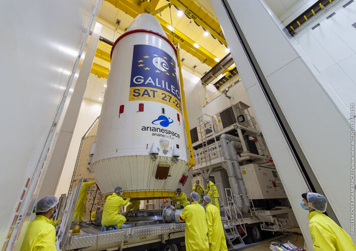
Europe’s next pair of Galileo satellites have been given a green light for launch. Last Friday’s Launch Readiness Review confirmed that the satellites, the supporting ground installations, and the early operations facilities and teams are ready for lift-off on the early hours of Thursday morning, European time.
Galileo satellites given green light for launch
29.11.2021 10:16 ESA Navigation
UPDATE: GALILEO LAUNCH NOW SCHEDULED FOR 3 DECEMBER AT 0127 CET (2 DECEMBER 2127 KOUROU TIME)
Europe’s next pair of Galileo satellites have been given a green light for launch. Last Friday’s Launch Readiness Review confirmed that the satellites, the supporting ground installations, and the early operations facilities and teams are ready for lift-off on the early hours of Thursday morning, European time.
Galileo satellites given green light for launch
29.11.2021 10:16 ESA Navigation
UPDATE: GALILEO LAUNCH NOW SCHEDULED FOR 3 DECEMBER AT 01:27 CET (2 DECEMBER 21:27 KOUROU TIME)
Europe’s next pair of Galileo satellites have been given a green light for launch. Last Friday’s Launch Readiness Review confirmed that the satellites, the supporting ground installations, and the early operations facilities and teams are ready for lift-off on the early hours of Thursday morning, European time.
Úspěch uživatelů ArcGIS v soutěži Egovernment The Best 2021
29.11.2021 9:52 ARCDATAMagazín Egovernment každoročně pořádá soutěž Egovernment The Best, ve které jsou oceňovány nejzajímavější projekty veřejné správy. Letos se na předních místech v kategorii krajů umístily hned dva projekty založené na technologiích Esri.
1. místo v kategorii krajů: Datový portál Královéhradeckého kraje a Katalog otevřených dat Královéhradeckého kraje
Cílem datového portálu Data KHK na adrese https://www.datakhk.cz bylo vytvořit centrální informační místo pro veřejnost a zároveň nabídnout veřejnosti otevřená data kraje na vysoce profesionální úrovni.
V současné době je v datovém katalogu 55 sad otevřených dat a přes 300 statistických ukazatelů v grafech. Zároveň je tento web rozcestníkem pro 16 webových portálů a 29 mapových aplikací kraje (většina z nich byla vytvořena pomocí produktů využívajících technologii ArcGIS), umístěno je zde 35 analýz, koncepcí a publikací z Královéhradeckého kraje. Je také rozcestníkem pro strategické a koncepční dokumenty kraje a je zde umístěno 30 datových karet ke zprávě o stavu kraje za rok 2020.
Datový portál Královéhradeckého kraje Data KHK je založen na technologii ArcGIS Hub a byl vytvořen pracovníky Odboru analýz a podpory řízení krajského úřadu a Centra investic, rozvoje a inovací, příspěvkové organizace kraje.

2. místo v kategorii krajů: Portál územního plánování Kraje Vysočina
Portál územního plánování Kraje Vysočina byl spuštěn na jaře tohoto roku a vy jste se s ním mohli seznámit již v přednášce na naší konferenci či v článku Kraj Vysočina spustil Portál územního plánování v časopisu ArcRevue. Cílem tvůrců bylo sjednotit dostupná data územně plánovacích podkladů a územně plánovacích dokumentací, ať již jde o územní plány jednotlivých obcí, zásady územního rozvoje, regulační plány, územní studie a územně analytické podklady. Dále také na jednom místě zpřístupnit data všem potenciálním uživatelům a zprostředkovat informace srozumitelným a uživatelsky přívětivým způsobem formou mapového atlasu.
Portál územního plánování Kraje Vysočina naleznete na adrese https://pupo.kr-vysocina.cz/

Autorům oceněných projektů srdečně gratulujeme a velmi nás těší, že pomocí technologie Esri vytvářejí takto úspěšné a užitečné projekty.
20211129 - volné místo - Ředitel/ředitelka KP Ústí n.L. na Katastrálním úřadu pro Ústecký kraj
29.11.2021 7:42 ČÚZK - předpisy a opatření Katastrální úřad pro Ústecký kraj - Katastrální pracoviště Ústí nad Labem zveřejnil novou aktualitu: Nabídka volného místa - služební místo představeného – Ředitel / ředitelka Katastrálního pracoviště Ústí nad Labem na Katastrálním úřadu pro Ústecký kraj20211129 - volné místo - Ředitel/ředitelka KP Ústí n.L. na Katastrálním úřadu pro Ústecký kraj
29.11.2021 7:42 ČÚZK /Urady/Katastralni-urady/Katastralni-urady/Katastralni-urad-pro-Ustecky-kraj/Katastralni-pracoviste/KP-Usti-nad-Labem/O-uradu/Aktuality/20211129-volne-misto-Reditel-reditelka-KP Usti20211129 - volné místo - Ředitel/ředitelka KP Ústí n.L. na Katastrálním úřadu pro Ústecký kraj
29.11.2021 7:42 ČÚZK /Urady/Katastralni-urady/Katastralni-urady/Katastralni-urad-pro-Ustecky-kraj/O-uradu/Aktuality/20211129-volne-misto-Reditel-reditelka-KP Usti20211129 - volné místo - Ředitel/ředitelka KP Ústí n.L. na Katastrálním úřadu pro Ústecký kraj
29.11.2021 7:42 ČÚZK - předpisy a opatření Katastrální úřad pro Ústecký kraj - Katastrální pracoviště Ústí nad Labem zveřejnil novou aktualitu: Nabídka volného místa - služební místo představeného – Ředitel / ředitelka Katastrálního pracoviště Ústí nad Labem na Katastrálním úřadu pro Ústecký krajŘeditel / ředitelka Katastrálního pracoviště Ústí nad Labem na Katastrálním úřadu pro Ústecký kraj
29.11.2021 7:40 ČÚZK - předpisy a opatření Katastrální úřad pro Ústecký kraj Katastrální pracoviště Ústí nad Labemvypisuje výběrové řízení na místo
Ředitel / ředitelka Katastrálního pracoviště Ústí nad Labem na Katastrálním úřadu pro Ústecký kraj
Ředitel / ředitelka Katastrálního pracoviště Ústí nad Labem na Katastrálním úřadu pro Ústecký kraj
29.11.2021 7:40 ČÚZK /Urady/Katastralni-urady/Katastralni-urady/Katastralni-urad-pro-Ustecky-kraj/Uredni-deska/Oznameni-a-jina-uredni-sdeleni/Volna-mista/DMS/Reditel-reditelka-Katastralniho-pracoviste UstiŘeditel / ředitelka Katastrálního pracoviště Ústí nad Labem na Katastrálním úřadu pro Ústecký kraj
29.11.2021 7:40 ČÚZK - volná místa Katastrální úřad pro Ústecký kraj Katastrální pracoviště Ústí nad Labem vypisuje výběrové řízení na místo Ředitel / ředitelka Katastrálního pracoviště Ústí nad Labem na Katastrálním úřadu pro Ústecký kraj"NVIDIA is Building a Digital Twin of the Earth" by Susan Smith
29.11.2021 7:14 GISCafe.com Webcasts-Webinars20211129 - volné místo - Vrchní/odborný referent v OOKO II. v technickém odboru na KÚ pro ÚK
29.11.2021 6:59 ČÚZK /Urady/Katastralni-urady/Katastralni-urady/Katastralni-urad-pro-Ustecky-kraj/O-uradu/Aktuality/20211129-volne-misto-Vrchni-odborny-referent-v20211129 - volné místo - Vrchní/odborný referent v OOKO II. v technickém odboru na KÚ pro ÚK
29.11.2021 6:59 ČÚZK - předpisy a opatření Katastrální úřad pro Ústecký kraj zveřejnil novou aktualitu: Nabídka volného místa - Vrchní referent / odborný referent v oddělení obnovy katastrálního operátu II. v technickém odboru na Katastrálním úřadu pro Ústecký krajVrchní referent / odborný referent v oddělení obnovy katastrálního operátu II. v technickém odboru n
29.11.2021 6:56 ČÚZK - volná místa Katastrální úřad pro Ústecký kraj technický odbor vypisuje výběrové řízení na místo Vrchní referent / odborný referent v oddělení obnovy katastrálního operátu II. v technickém odboru nVrchní referent / odborný referent v oddělení obnovy katastrálního operátu II. v technickém odboru n
29.11.2021 6:56 ČÚZK - předpisy a opatření Katastrální úřad pro Ústecký kraj technický odborvypisuje výběrové řízení na místo
Vrchní referent / odborný referent v oddělení obnovy katastrálního operátu II. v technickém odboru na Katastrálním úřadu pro Ústecký kraj
Vrchní referent / odborný referent v oddělení obnovy katastrálního operátu II. v technickém odboru n
29.11.2021 6:56 ČÚZK /Urady/Katastralni-urady/Katastralni-urady/Katastralni-urad-pro-Ustecky-kraj/Uredni-deska/Oznameni-a-jina-uredni-sdeleni/Volna-mista/DMS/Vrchni-referent-odborny-referent-v oddeleni-obnoVizualizace + konstrukční výkresy
27.11.2021 16:28 ŠPINAR - softwareVážení zákazníci,
na této stránce prezentujeme výstupy konstrukčních výkresů, které uživatelé vytvářeli v programech TurboCAD a DAEX. Zkvalitněte si i Vy Vaši práci.
The post Vizualizace + konstrukční výkresy appeared first on ŠPINAR – software.
Konstrukční výkresy + vizualizace
27.11.2021 16:28 ŠPINAR - softwareVážení zákazníci,
na této stránce prezentujeme výstupy konstrukčních výkresů, které uživatelé vytvářeli v programech TurboCAD a DAEX. Zkvalitněte si i Vy Vaši práci.
The post Konstrukční výkresy + vizualizace appeared first on ŠPINAR – software.
Vizualizace + konstrukční výkresy
27.11.2021 16:28 ŠPINAR - softwareVážení zákazníci,
na této stránce prezentujeme výstupy konstrukčních výkresů, které uživatelé vytvářeli v programech TurboCAD a DAEX. Zkvalitněte si i Vy Vaši práci.
The post Vizualizace + konstrukční výkresy appeared first on ŠPINAR – software.
Konstrukční výkresy + vizualizace
27.11.2021 16:28 ŠPINAR - software Vážení zákazníci,na této stránce prezentujeme výstupy konstrukčních výkresů, které uživatelé vytvářeli v programech TurboCAD a DAEX. Zkvalitněte si i Vy Vaši práci.
Listopadový brněnský Missing maps mapathon na Geografickém ústavu
26.11.2021 18:00 Geografický ústav MUPřijďte podpořit práci Lékařů bez hranic tím, že pomůžete do otevřené mapy světa OpenStreetMap zmapovat místa, která jsou ohrožena humanitárními krizemi.
Je to více než rok, co se v Brně konal klasický prezenční mapathon, kde se všichni sešli a mapovali na jednom místě. Během měsíců, kdy prezenční mapathony nebyly možné, je nahradily online mapathony, kterých se mohou zúčastnit i ti, kteří nemohou přicestovat na klasický mapathon. Mnohé mapathony tak budou dále umožňovat online účast i během prezenčních mapathonů. Listopadový brněnský mapathon bude jedním z nich.
Mapy, družicové snímky, exotické země, rozvojová pomoc - všechna tato témata spadají do Geografie. I proto bude náš brněnský listopadový mapathon pořádán v rámci Dnů geografie. O této mezinárodní akci se více dočtete na https://www.dnygeografie.cz/.
pátek 26. listopadu 2021 od 18:00 do 21:00
Geografický ústav, Přírodovědecká fakulta, Masarykova univerzita,
učebna Z1, budova 5
Kotlářská 267/2, 602 00 Brno
Přesné místo mapathonu: https://www.openstreetmap.org/way/50048465
Co se na mapathonu bude dít?
Na mapathonu budeme společně podle satelitních snímků vytvářet v OpenStreetMap mapu jednoho z míst, na kterém působí Lékaři bez hranic. Pokud nemáte zkušenosti, nevadí. Všechno se na místě naučíte a po krátkém školení už budete moci sami mapovat. Pokud máte zkušenosti, tím lépe. Budeme pracovat ve třech skupinách:
- Skupina začátečníků bude při školení získávat první zkušenosti s editací OpenStreetMap
- Zkušenější mapéři se budou mít možnost naučit program JOSM – volně dostupný pokročilý editor pro OpenStreetMap.
- Ti, kteří už umí alespoň základy JOSM, se mohou vyškolit na validátory, kteří kontrolují výsledky práce dalších mapérů. Vyškolení co největšího počtu validátorů je aktuálně ten nejdůležitější úkol mapathonů po celém světě. Jsou nedostatkoví a vážení, tak se přidejte.
Samozřejmě, zváni jsou i zkušení uživatelé, kteří už žádné školení nepotřebují a chtějí jen nerušeně mapovat. Pokud již patříte mezi zkušené a chtěli byste se přidat do organizačního týmu, tak se na tom na mapathonu rádi domluvíme.
Co potřebujete?
Není potřeba mít předchozí zkušenosti. Veškeré nástroje jsou zdarma a open source.
Začátečníci mohou přijít i bez vlastního notebooku. Budeme mít k dispozici počítačovou učebnu.
Pokud však chcete být v jedné z pokročilejších skupin, je potřeba si vzít vlastní notebook a myš. Bezdrátový internet bude zajištěn.
Mám si něco připravit?
Pokud ještě nemáte účet na OpenStreetMap, vytvořte si ho zde: https://www.openstreetmap.org/user/new.
Pokud chcete být ve skupině pokročilých mapérů učících se JOSM, je vhodné mít na počítači předem nainstalován program JOSM. Je volně ke stažení na adrese https://josm.openstreetmap.de. Program vyžaduje nainstalovaný programovací jazyk Java.
Pokud chcete být ve skupině validátorů, je výhodou již alespoň základní znalost editoru JOSM. Ideální je proto nejdříve absolvovat mapathon ve skupině JOSM a na následujícím mapathonu přejít k validátorům.
Těší se na Vás Geografický ústav Přírodovědecké fakulty Masarykovy univerzity a organizační tým brněnských mapathonů (Katka, Radim, Daniel, Miloslav). Spoluorganizátorem listopadového brněnského mapathonu je také Amavet 962.
Bližší informace: Radim Štampach (stampach@mail.muni.cz)
Listopadový brněnský Missing maps mapathon na Geografickém ústavu
26.11.2021 18:00 Geografický ústav MUPřijďte podpořit práci Lékařů bez hranic tím, že pomůžete do otevřené mapy světa OpenStreetMap zmapovat místa, která jsou ohrožena humanitárními krizemi.
Je to více než rok, co se v Brně konal klasický prezenční mapathon, kde se všichni sešli a mapovali na jednom místě. Během měsíců, kdy prezenční mapathony nebyly možné, je nahradily online mapathony, kterých se mohou zúčastnit i ti, kteří nemohou přicestovat na klasický mapathon. Mnohé mapathony tak budou dále umožňovat online účast i během prezenčních mapathonů. Listopadový brněnský mapathon bude jedním z nich.
Na základě doporučení krizového výboru Masarykovy univerzity bylo rozhodnuto, že se mapathon odehraje jen v online prostoru. Odkaz pro připojení a další informace bude přihlášeným účastníkům zaslán několik dní před začátkem mapathonu.
Mapy, družicové snímky, exotické země, rozvojová pomoc - všechna tato témata spadají do Geografie. I proto bude náš brněnský listopadový mapathon pořádán v rámci Dnů geografie. O této mezinárodní akci se více dočtete na https://www.dnygeografie.cz/.
pátek 26. listopadu 2021 od 18:00 do 21:00
online, odkaz pro připojení bude přihlášeným účastníkům zaslán několik dní předem
Co se na mapathonu bude dít?
Na mapathonu budeme společně podle satelitních snímků vytvářet v OpenStreetMap mapu jednoho z míst, na kterém působí Lékaři bez hranic. Pokud nemáte zkušenosti, nevadí. Všechno se na místě naučíte a po krátkém školení už budete moci sami mapovat. Pokud máte zkušenosti, tím lépe. Budeme pracovat ve třech skupinách:
- Skupina začátečníků bude při školení získávat první zkušenosti s editací OpenStreetMap
- Zkušenější mapéři se budou mít možnost naučit program JOSM – volně dostupný pokročilý editor pro OpenStreetMap.
- Ti, kteří už umí alespoň základy JOSM, se mohou vyškolit na validátory, kteří kontrolují výsledky práce dalších mapérů. Vyškolení co největšího počtu validátorů je aktuálně ten nejdůležitější úkol mapathonů po celém světě. Jsou nedostatkoví a vážení, tak se přidejte.
Samozřejmě, zváni jsou i zkušení uživatelé, kteří už žádné školení nepotřebují a chtějí jen nerušeně mapovat. Pokud již patříte mezi zkušené a chtěli byste se přidat do organizačního týmu, tak se na tom na mapathonu rádi domluvíme.
Co potřebujete?
Není potřeba mít předchozí zkušenosti. Veškeré nástroje jsou zdarma a open source.
Setkání se uskuteční online, je potřeba mít vlastní počítač/notebook, myš a připojení k internetu.
Mám si něco připravit?Pokud ještě nemáte účet na OpenStreetMap, vytvořte si ho zde: https://www.openstreetmap.org/user/new.
Pokud chcete být ve skupině pokročilých mapérů učících se JOSM, je vhodné mít na počítači předem nainstalován program JOSM. Je volně ke stažení na adrese https://josm.openstreetmap.de. Program vyžaduje nainstalovaný programovací jazyk Java.
Pokud chcete být ve skupině validátorů, je výhodou již alespoň základní znalost editoru JOSM. Ideální je proto nejdříve absolvovat mapathon ve skupině JOSM a na následujícím mapathonu přejít k validátorům.
Těší se na Vás Geografický ústav Přírodovědecké fakulty Masarykovy univerzity a organizační tým brněnských mapathonů (Katka, Radim, Daniel, Miloslav). Spoluorganizátorem listopadového brněnského mapathonu je také Amavet 962.
Bližší informace: Radim Štampach (stampach@mail.muni.cz)
Galileo: en route to full operational capability
26.11.2021 13:00 ESA Navigation Video:
00:05:36
Video:
00:05:36
Soon another pair of Galileo satellites will be launched on top of a Soyuz from Europe spaceport in French Guiana. These satellites are the first of the so-called 'Batch 3', comprising of 12 additional first-generation Galileo satellites commissioned in 2017 to bring the constellation to full operational capability. They will be used to further expand the constellation up to 38 satellites and act as backups and spares for satellites that reach their end-of-life.
This 11th Galileo launch also marks the 10 year anniversary of the first launch of the Galileo operational satellites and the start of the construction of the constellation. Ten years later Galileo is the most accurate satellite navigation system in the world and available on every recent smartphone and device. It is also two decades since satellite navigation was first introduced as a completely new activity in the European space sector.
Meanwhile ESA continues to ensure the future of the Galileo programme and European expertise in satellite navigation. For Galileo ESA has already commissioned a second generation of more powerful and flexible navigation satellites while new services are being developed to meet market demand.
Aktualizace dat a prohlížecí služby nové podoby SM 5
26.11.2021 11:05 ČÚZK - Geoportál Aktualizace dat a prohlížecí služby nové podoby SM 5Byla provedena pravidelná roční aktualizace nové podoby Státní mapy 1:5 000.
Aktualizovaná data poskytuje i prohlížecí služba.
Grafická přehledka pokrytí s informacemi o jednotlivých mapových listech viz: stav aktualizace
Earth from Space: Kainji Lake
26.11.2021 10:00 ESA Observing the Earth
Kainji Lake, a reservoir on the Niger River in western Nigeria, is featured in this true-colour image captured by the Copernicus Sentinel-2 mission.
Schránka pro příjem podání
26.11.2021 8:35 ČÚZK /Urady/Katastralni-urady/Katastralni-urady/Katastralni-urad-pro-Kralovehradecky-kraj/Katastralni-pracoviste/KP-Nachod/O-uradu/Aktuality/Schranka-pro-prijem-podaniSchránka pro příjem podání
26.11.2021 8:35 ČÚZK - předpisy a opatření Katastrální úřad pro Královéhradecký kraj - Katastrální pracoviště Náchod zveřejnil novou aktualitu: Vážení klienti,s účinností od 26. 11. 2021 je na Katastrálním pracovišti Náchod instalována schránka pro příjem podání. Tato schránka je určena pro bezkontaktní podání návrhů na vklad a dalších písemností určených tomuto pracovišti. Schránka je pravidelně vybírána, okamžikem podání je okamžik výběru schránky. Příjem podání bude potvrzen spolu s případným podkladem pro platbu správního poplatku na Vámi sdělenou e-mailovou adresu.
Black Friday u Arkance Systems – sleva 20 % na produkty firmy Autodesk
26.11.2021 0:00 Arkance SystemsCelosvětová akce Cyber Week je tady! Pořiďte si CAD, CAM, BIM nebo multimédia software od Autodesku za zvýhodněné ceny
Zpráva Black Friday u Arkance Systems – sleva 20 % na produkty firmy Autodesk pochází z arkance-systems.cz.
Galileos attached to upper stage as launch draws near
25.11.2021 17:24 ESA Navigation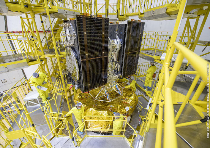 Image:
Galileos attached to upper stage as launch draws near
Image:
Galileos attached to upper stage as launch draws near
Galileo satellites in place for launch
25.11.2021 17:08 ESA Navigation
Europe’s next two Galileo satellites have been attached to the dispenser on which they will ride to orbit, and the launcher fairing that will protect them during the first part of the ascent to orbit has been closed around the pair.
neXat platform opens new global markets for MT
25.11.2021 15:58 GISCafe.com Webcasts-Webinars neXat’s new eMarketplace feature will help the teleport operator offer more services and reach new marketsBrussels, Belgium and Milan, Italy …
vedoucí oddělení aktualizace a dokumentace KN Katastrálního pracoviště Český Krumlov (ID SM 30000159
25.11.2021 14:21 ČÚZK - předpisy a opatření Katastrální úřad pro Jihočeský kraj Katastrální pracoviště Český Krumlovvypisuje výběrové řízení na místo
vedoucí oddělení aktualizace a dokumentace KN Katastrálního pracoviště Český Krumlov (ID SM 30000159/30003783)
vedoucí oddělení aktualizace a dokumentace KN Katastrálního pracoviště Český Krumlov (ID SM 30000159
25.11.2021 14:21 ČÚZK - volná místa Katastrální úřad pro Jihočeský kraj Katastrální pracoviště Český Krumlov vypisuje výběrové řízení na místo vedoucí oddělení aktualizace a dokumentace KN Katastrálního pracoviště Český Krumlov (ID SM 30000159vedoucí oddělení aktualizace a dokumentace KN Katastrálního pracoviště Český Krumlov (ID SM 30000159
25.11.2021 14:21 ČÚZK /Urady/Katastralni-urady/Katastralni-urady/Katastralni-urad-pro-Jihocesky-kraj/Uredni-deska/Oznameni-a-jina-uredni-sdeleni/Volna-mista/DMS/vedouci-oddeleni-aktualizace-a-dokumentace-KN-KataOdborný referent/vrchní referent v oddělení obnovy katastrálního operátu č.3 na Technické sekci
25.11.2021 12:48 ČÚZK - volná místa Katastrální úřad pro Jihomoravský kraj technická sekce vypisuje výběrové řízení na místo Odborný referent/vrchní referent v oddělení obnovy katastrálního operátu č.3 na Technické sekciOdborný referent/vrchní referent v oddělení obnovy katastrálního operátu č.3 na Technické sekci
25.11.2021 12:48 ČÚZK - předpisy a opatření Katastrální úřad pro Jihomoravský kraj technická sekcevypisuje výběrové řízení na místo
Odborný referent/vrchní referent v oddělení obnovy katastrálního operátu č.3 na Technické sekci
Odborný referent/vrchní referent v oddělení obnovy katastrálního operátu č.3 na Technické sekci
25.11.2021 12:48 ČÚZK /Urady/Katastralni-urady/Katastralni-urady/Katastralni-urad-pro-Jihomoravsky-kraj/Uredni-deska/Oznameni-a-jina-uredni-sdeleni/Volna-mista/DMS/Odborny-referent-vrchni-referent-v-oddeleni-obnovyAliance a CzechTrade pořádali konference k obchodním příležitostem v UAV průmyslu v Asii
25.11.2021 11:16 UAVATento týden v úterý 23.11. a v čtvrtek 25.11. jsme spolupořádali s CzechTrade dvě online konference o možnostech spolupráce v bezpilotním leteckém průmyslu v Asii. O úvodní slovo se postaral prezident Aliance pro bezpilotní letecký průmysl Jakub Karas. V úterý byla konference zaměřena na spolupráci v Singapuru a v Číně, včetně prezentací lokálních zástupců CzechTrade […]
The post Aliance a CzechTrade pořádali konference k obchodním příležitostem v UAV průmyslu v Asii appeared first on UAV Aliance pro bezpilotní letecký průmysl.
Orientované snímky v ArcGIS – Oriented Imagery
25.11.2021 11:03 blog ARCDATA Co to jsou orientované snímky? Jak takové snímky získat? K čemu nám slouží a jak je možné je využít v prostředí ArcGIS? To vše se dozvíte v tomto článku.odborný referent / vrchní referent v oddělení právních vztahů
25.11.2021 10:13 ČÚZK - předpisy a opatření Katastrální úřad pro Liberecký kraj - Katastrální pracoviště Semilyvypisuje výběrové řízení na místo
odborný referent / vrchní referent v oddělení právních vztahů
odborný referent / vrchní referent v oddělení právních vztahů
25.11.2021 10:13 ČÚZK /Urady/Katastralni-urady/Katastralni-urady/Katastralni-urad-pro-Liberecky-kraj/Uredni-deska/Oznameni-a-jina-uredni-sdeleni/Volna-mista/odborny-referent-vrchni-referent-v-oddeleni-praodborný referent / vrchní referent v oddělení právních vztahů
25.11.2021 10:13 ČÚZK - volná místa Katastrální úřad pro Liberecký kraj - Katastrální pracoviště Semily vypisuje výběrové řízení na místo odborný referent / vrchní referent v oddělení právních vztahůOzn_vyhl_-vyberoveho_rizeni_KP_PM
25.11.2021 9:42 ČÚZK /Urady/Katastralni-urady/Katastralni-urady/Katastralni-urad-pro-Plzensky-kraj/O-uradu/Aktuality/Ozn_vyhl_-vyberoveho_rizeni_KP_PMOzn_vyhl_-vyberoveho_rizeni_KP_PM
25.11.2021 9:42 ČÚZK - předpisy a opatření Český úřad zeměměřický a katastrální - Katastrální pracoviště Plzeň-město zveřejnil novou aktualitu: Oznámení o vyhlášení výběrového řízení na služební místo odborný/vrchní referent – poskytování informací KN PIKN1003,oddělení dokumentace KN, Katastrální úřad pro Plzeňský kraj, Katastrální pracoviště Plzeň - město
Ozn_vyhl_-vyberoveho_rizeni_KP_PM
25.11.2021 9:42 ČÚZK - předpisy a opatření Český úřad zeměměřický a katastrální - Katastrální pracoviště Plzeň-město zveřejnil novou aktualitu: Oznámení o vyhlášení výběrového řízení na služební místo odborný/vrchní referent – poskytování informací KN PIKN1003,oddělení dokumentace KN, Katastrální úřad pro Plzeňský kraj, Katastrální pracoviště Plzeň - město
Oznámení o vyhlášení výběrového řízení na služební místo odborný/vrchní referent – poskytování info
25.11.2021 9:22 ČÚZK /Urady/Katastralni-urady/Katastralni-urady/Katastralni-urad-pro-Plzensky-kraj/Uredni-deska/Oznameni-a-jina-uredni-sdeleni/Volna-mista/DMS/Oznameni-o-vyhlaseni-vyberoveho-rizeni-na-sluzebniOznámení o vyhlášení výběrového řízení na služební místo odborný/vrchní referent – poskytování info
25.11.2021 9:22 ČÚZK - volná místa Katastrální úřad pro Plzeňský kraj Katastrální pracoviště Plzeň-město vypisuje výběrové řízení na místo Oznámení o vyhlášení výběrového řízení na služební místo odborný/vrchní referent – poskytování infoOznámení o vyhlášení výběrového řízení na služební místo odborný/vrchní referent – poskytování info
25.11.2021 9:22 ČÚZK - předpisy a opatření Katastrální úřad pro Plzeňský kraj Katastrální pracoviště Plzeň-městovypisuje výběrové řízení na místo
Oznámení o vyhlášení výběrového řízení na služební místo odborný/vrchní referent – poskytování informací KN PIKN1003
Autodesk to Present at Upcoming Investor Conferences
25.11.2021 9:00 GISCafe.com Webcasts-Webinars SAN FRANCISCO, Nov. 24, 2021 — (PRNewswire) — Autodesk, Inc. (NASDAQ: ADSK) today announced its executives will be speaking …Odstávka mapových aplikací Geoportálu a výdeje dat
25.11.2021 7:40 Jihočeský krajOd pátku 26.11.2021 od 16:00 budou z technických důvodů nedostupné mapové aplikace Geoportálu a nebude možné žádat o výdej dat. Obnovení plného provozu předpokládáme v sobotu 27.11.2021 ve večerních hodinách.
rnrnOmlouváme se za komplikace
Inpixon Recognized as an IDC Innovator for Location & Geospatial Intelligence
24.11.2021 18:01 GISCafe.com Webcasts-Webinars Overall Maturity of the Inpixon Platform Identified as Key DifferentiatorPALO ALTO, Calif., Nov. 24, 2021 — (PRNewswire) — Inpixon …
2021124_Odborný referent / vrchní referent oddělení dokumentace katastru nemovitostí
24.11.2021 14:58 ČÚZK - předpisy a opatření Katastrální úřad pro Středočeský kraj - Katastrální pracoviště Rakovník Vyhlášení výběrového řízení: Odborný referent / vrchní referent oddělení dokumentace katastru nemovitostí V části "Úřední deska", v sekci "Oznámení a jiná úřední sdělení" bylo vystaveno "Oznámení o vyhlášení výběrového řízení na obsazení služebního místa Odborný referent / vrchní referent oddělení dokumentace katastru nemovitostí"2021124_Odborný referent / vrchní referent oddělení dokumentace katastru nemovitostí
24.11.2021 14:58 ČÚZK /Urady/Katastralni-urady/Katastralni-urady/Katastralni-urad-pro-Stredocesky-kraj/Katastralni-pracoviste/KP-Rakovnik/O-uradu/Aktuality/20210922_Odborny-referent-oddeleni-aktualizace-(3)Odborný referent / vrchní referent oddělení dokumentace katastru nemovitostí
24.11.2021 14:56 ČÚZK - volná místa Katastrální úřad pro Středočeský kraj - Katastrální pracoviště Rakovník vypisuje výběrové řízení na místo Odborný referent / vrchní referent oddělení dokumentace katastru nemovitostíOdborný referent / vrchní referent oddělení dokumentace katastru nemovitostí
24.11.2021 14:56 ČÚZK /Urady/Katastralni-urady/Katastralni-urady/Katastralni-urad-pro-Stredocesky-kraj/Uredni-deska/Oznameni-a-jina-uredni-sdeleni/Volna-mista/Odborny-referent-vrchni-referent-oddeleni-dokumeOdborný referent / vrchní referent oddělení dokumentace katastru nemovitostí
24.11.2021 14:56 ČÚZK - předpisy a opatření Katastrální úřad pro Středočeský kraj - Katastrální pracoviště Rakovníkvypisuje výběrové řízení na místo Odborný referent / vrchní referent oddělení dokumentace katastru nemovitostí
Odborný referent / vrchní referent oddělení dokumentace katastru nemovitostí