


![]()

zprávy
zdroje zpráv:Odstávka platebního portálu
19.11.2021 10:00 ČÚZK - Geoportál Odstávka platebního portáluV pátek 26.11.2021 od 14:30 do 21:00 hod proběhne plánovaná odstávka platebního portálu. V tomto období nebude možné platit objednávky v e-shopu platební kartou, bude tedy nutné zvolit jiný způsob platby.
Omlouváme se za případné komplikace.
Odstávka platebního portálu
19.11.2021 10:00 ČÚZK - Geoportál Odstávka platebního portáluV pátek 26.11.2021 od 14:30 do 21:00 hod proběhne plánovaná odstávka platebního portálu. V tomto období nebude možné platit objednávky v e-shopu platební kartou, bude tedy nutné zvolit jiný způsob platby.
Omlouváme se za případné komplikace.
Earth from Space: Kuala Lumpur, Malaysia
19.11.2021 10:00 ESA Observing the Earth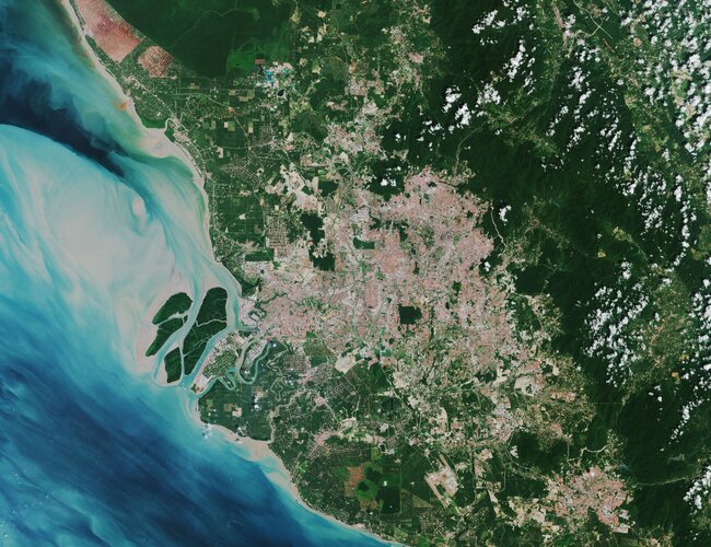
Kuala Lumpur, the capital city of Malaysia, is featured in this image captured by the Copernicus Sentinel-2 mission.
Zlaté medaile Přírodovědecké fakulty pro profesora Konečného a profesora Proška
19.11.2021 10:00 Geografický ústav MUSwift Navigation Named to Fast Company’s Next Big Things in Tech
19.11.2021 9:00 GISCafe.com Webcasts-Webinars SAN FRANCISCO, Nov. 18, 2021 (GLOBE NEWSWIRE) -- Swift Navigation, a San Francisco-based tech firm redefining GNSS (Global Navigation Satellite …Bluesky National Tree Map Data Included in First Online Natural Capital Calculator
19.11.2021 9:00 GISCafe.com Webcasts-Webinars Leicestershire, UK, 17 November 2021 - The first online natural capital mapping tool in the UK - NatCap Map - is using data from Bluesky’s …Maxar Technologies to Participate in Upcoming Investor Conferences
19.11.2021 9:00 GISCafe.com Webcasts-Webinars WESTMINSTER, Colo. — (BUSINESS WIRE) — November 17, 2021 — Maxar Technologies (NYSE:MAXR) (TSX:MAXR), a trusted partner and …Satellogic Accelerates Growth with Leadership Appointments
19.11.2021 9:00 GISCafe.com Webcasts-Webinars Leadership hires across Corporate Development, Human Resources, Financial Reporting and Sales will further build on industry leading Earth …Alpine 4 Holdings (ALPP) Subsidiary, Identified Technologies, has Been Awarded a Multi-Year Drone-Mapping Contract with The US Army Corps of Engineers
18.11.2021 17:44 GISCafe.com Webcasts-Webinars PHOENIX, Nov. 18, 2021 — (PRNewswire) — Alpine 4 Holdings, Inc. (Nasdaq: ALPP), a leading operator and owner of small market …Ferguson Waterworks Partners with Trimble to Offer Utilities Greater Access to Technology for Digitizing Water and Wastewater Assets
18.11.2021 17:12 GISCafe.com Webcasts-Webinars SUNNYVALE, Calif., Nov. 18, 2021 — (PRNewswire) — Trimble (NASDAQ: TRMB) and Ferguson Waterworks announced today a collaboration, which …Kongsberg Geospatial TerraLens Technology enables Next Generation Surface Search Radar Displays
18.11.2021 17:12 GISCafe.com Webcasts-Webinars TerraLens Geospatial SDK map engine selected by Ultra Naval Systems and Sensors to provide the geospatial and rendering engine for the next …Hawkeye Provides Shareholder Update
18.11.2021 17:12 GISCafe.com Webcasts-Webinars Acquisition of Six15 Technologies progresses, Nasdaq up list planned for 2022SAVANNAH, Ga., Nov. 18, 2021 — (PRNewswire) — …
Nearmap Enhances and Expands Program in North America to Assist Disaster Relief Efforts Following Catastrophic Weather
18.11.2021 17:12 GISCafe.com Webcasts-Webinars SALT LAKE CITY, Nov. 18, 2021 (GLOBE NEWSWIRE) -- Leading aerial imagery and location intelligence company Nearmap has announced a major …Washington state flooding
18.11.2021 14:50 ESA Observing the Earth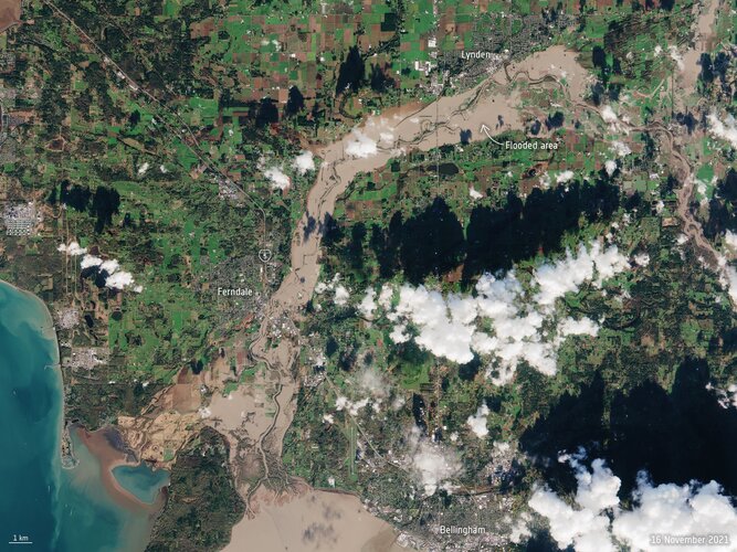 Image:
The US State of Washington is under a state of emergency following days of severe wind and rain leading to extensive flooding in parts of the state. Different satellites in orbit carry different instruments that can provide us with a wealth of complementary information to understand and to respond to flooding disasters.
Image:
The US State of Washington is under a state of emergency following days of severe wind and rain leading to extensive flooding in parts of the state. Different satellites in orbit carry different instruments that can provide us with a wealth of complementary information to understand and to respond to flooding disasters.
Omezení telefonních hovorů 26.11.2021
18.11.2021 14:48 ČÚZK /Urady/Katastralni-urady/Katastralni-urady/Katastralni-urad-pro-Moravskoslezsky-kraj/Katastralni-pracoviste/KP-Ostrava/O-uradu/Aktuality/Omezeni-telefonnich-hovoru-26-11-2021Omezení telefonních hovorů 26.11.2021
18.11.2021 14:48 ČÚZK - předpisy a opatření Katastrální úřad pro Moravskoslezský kraj - Katastrální pracoviště Ostravazveřejnil novou aktualitu: Dne 26. 11. 2021 bude v době od 8h do 12h probíhat výměna telefonní ústředny Katastrálního pracoviště Ostrava. V této době tedy nebude možné realizovat telefonní hovory. Žádáme klienty, aby využívali po tuto dobu pro komunikaci s pracovištěm e-mailovou adresu: kp.ostrava@cuzk.cz
ředitel odboru - ředitel/ka Katastrálního pracoviště Strakonice (ID SM 30000277/30003901)
18.11.2021 13:58 ČÚZK - volná místa Katastrální úřad pro Jihočeský kraj Katastrální pracoviště Strakonice vypisuje výběrové řízení na místo ředitel odboru - ředitel/ka Katastrálního pracoviště Strakonice (ID SM 30000277/30003901)ředitel odboru - ředitel/ka Katastrálního pracoviště Strakonice (ID SM 30000277/30003901)
18.11.2021 13:58 ČÚZK /Urady/Katastralni-urady/Katastralni-urady/Katastralni-urad-pro-Jihocesky-kraj/Uredni-deska/Oznameni-a-jina-uredni-sdeleni/Volna-mista/DMS/reditel-odboru-reditel-ka-Katastralniho-pracovisředitel odboru - ředitel/ka Katastrálního pracoviště Strakonice (ID SM 30000277/30003901)
18.11.2021 13:58 ČÚZK - předpisy a opatření Katastrální úřad pro Jihočeský kraj Katastrální pracoviště Strakonicevypisuje výběrové řízení na místo
ředitel odboru - ředitel/ka Katastrálního pracoviště Strakonice (ID SM 30000277/30003901)
Odborný referent v oddělení právních vztahů k nemovitostem Katastrálního pracoviště Rychnov nad Kněž
18.11.2021 7:58 ČÚZK - předpisy a opatření Katastrální úřad pro Královéhradecký kraj Katastrální pracoviště Rychnov nad Kněžnouvypisuje výběrové řízení na místo
Odborný referent v oddělení právních vztahů k nemovitostem Katastrálního pracoviště Rychnov nad Kněžnou
Odborný referent v oddělení právních vztahů k nemovitostem Katastrálního pracoviště Rychnov nad Kněž
18.11.2021 7:58 ČÚZK /Urady/Katastralni-urady/Katastralni-urady/Katastralni-urad-pro-Kralovehradecky-kraj/Volna-mista/DMS/Odborny-referent-v-oddeleni-pravnich-vztahu-k-nemoOdborný referent v oddělení právních vztahů k nemovitostem Katastrálního pracoviště Rychnov nad Kněž
18.11.2021 7:58 ČÚZK - volná místa Katastrální úřad pro Královéhradecký kraj Katastrální pracoviště Rychnov nad Kněžnou vypisuje výběrové řízení na místo Odborný referent v oddělení právních vztahů k nemovitostem Katastrálního pracoviště Rychnov nad KněžMapsted offers the world's first self-serve indoor mapping plans for purchase
18.11.2021 2:44 GISCafe.com Webcasts-Webinars Mapsted releases a new way to start your indoor mapping venture by simply visiting the pricing page on their website.TORONTO, Nov. 17, 2021 — …
Riverside Research's Commercial Innovation Center (CIC) and T-REX Innovation Center Announce Partnership
18.11.2021 2:44 GISCafe.com Webcasts-Webinars WASHINGTON, Nov. 17, 2021 — (PRNewswire) — Riverside Research's Commercial Innovation Center (CIC) and St. Louis, Missouri-based …Křest knihy Konfliktní regiony světa – Evropa [Knihovna geografie, byTopic]
18.11.2021 0:00 Katedra aplikované geoinformatiky a kartografie Přf UK V rámci Dnů geografie 2021 se v pondělním odpoledni 15.11.2021 uskutečnil v Knihovně geografie křest nové knihy dr. Libora Jelena.Pozvánka na přednášky prof. Piégaye
18.11.2021 0:00 Geografický ústav MU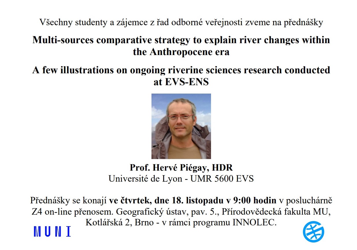
Percepto launches new drone and advanced AI-powered analytics for its 2022 Autonomous Inspection & Monitoring platform
17.11.2021 21:32 GISCafe.com Webcasts-Webinars MODI'IN, Israel, Nov. 17, 2021 — (PRNewswire) — Percepto, pioneering autonomous inspection with industrial robotics, announced today the …Esri Releases Moving Forward: GIS for Transportation
17.11.2021 17:04 GISCafe.com Webcasts-Webinars New Book Showcases How Location Intelligence Can Innovate Transportation InfrastructureREDLANDS, Calif. — (BUSINESS WIRE) — November 17, …
Panzura Rolls Out 2nd-Gen Panzura Data Services With Complementary and Paid Tiers, Simplified Value-based Pricing
17.11.2021 17:04 GISCafe.com Webcasts-Webinars Shift to Consumption-based Model, No-Cost Basic and Licensed Service Options, Delivers Observability and Visibility That Scales With Every CloudFS …Woolpert Contracted by SCDOT to Provide Statewide, On-Call Photogrammetric Services
17.11.2021 17:04 GISCafe.com Webcasts-Webinars The firm will deliver aerial and mobile mapping lidar data, ground control survey and UAS services.COLUMBIA, S.C., Nov. 17, 2021 — …
Bentley Systems Enters into Agreement to Acquire Power Line Systems
17.11.2021 3:13 Bentley SystemsPress Announcements
Martin UAV Kicks Off MTUAS Increment 2 Effort with Naval Air Warfare Center Aircraft Division
17.11.2021 1:15 GISCafe.com Webcasts-Webinars SAN DIEGO, Nov. 16, 2021 — (PRNewswire) — Shield AI, the defense-technology company using self-driving software to enable …ImageCat announces the availability of Fathom's global flood data in Inhance and FACFinder software suites to deliver flood risk intelligence
17.11.2021 1:14 GISCafe.com Webcasts-Webinars Fathom's global flood data in Inhance and FACFinder software suites provide flood risk intelligence to insurance, real estate, and international …Planet Federal Signs Contract Extension with National Reconnaissance Office
16.11.2021 17:43 GISCafe.com Webcasts-Webinars SAN FRANCISCO — (BUSINESS WIRE) — November 16, 2021 —Planet, a leading provider of daily data and insights about the Earth, today …
Intermap Reports 19% Sequential Growth for Q3 2021
16.11.2021 17:43 GISCafe.com Webcasts-Webinars DENVER, Nov. 16, 2021 — (PRNewswire) — Intermap Technologies (TSX: IMP) (OTCQX: ITMSF) ("Intermap" or the "Company"), a global leader in …Software Drives Water System Improvements
16.11.2021 16:56 Bentley SystemsPressCoverage
Cadalyst, USA
Read the articleProjectWise Now for Small and Medium Sized Businesses
16.11.2021 16:45 Bentley SystemsPressCoverage
ENR, USA
Read the articleBentley 2021 YII Geotechnical Award Finalists
16.11.2021 16:32 Bentley SystemsPressCoverage
Geoprac.net, USA
Read the articleLumentum Announces Breakthrough High-Performance Multi-Junction Addressable VCSEL Arrays for Long-Range LiDAR Applications
16.11.2021 16:32 GISCafe.com Webcasts-Webinars SAN JOSE, Calif., Nov. 16, 2021 — (PRNewswire) — Lumentum Holdings Inc. ("Lumentum"), a leading provider of vertical-cavity …Rada / odborný rada rada / odborný rada v oddělení aktualizace Katastrálního pracoviště Hradec Králo
16.11.2021 13:43 ČÚZK /Urady/Katastralni-urady/Katastralni-urady/Katastralni-urad-pro-Kralovehradecky-kraj/Uredni-deska/Oznameni-a-jina-uredni-sdeleni/Volna-mista/DMS/Rada-odborny-rada-rada-odborny-rada-v-oddeleniRada / odborný rada rada / odborný rada v oddělení aktualizace Katastrálního pracoviště Hradec Králo
16.11.2021 13:43 ČÚZK - volná místa Katastrální úřad pro Královéhradecký kraj Katastrální pracoviště Hradec Králové vypisuje výběrové řízení na místo Rada / odborný rada rada / odborný rada v oddělení aktualizace Katastrálního pracoviště Hradec KráloRada / odborný rada rada / odborný rada v oddělení aktualizace Katastrálního pracoviště Hradec Králo
16.11.2021 13:43 ČÚZK - předpisy a opatření Katastrální úřad pro Královéhradecký kraj Katastrální pracoviště Hradec Královévypisuje výběrové řízení na místo
Rada / odborný rada v oddělení aktualizace Katastrálního pracoviště Hradec Králové
Rada / odborný rada rada / odborný rada v oddělení aktualizace Katastrálního pracoviště Hradec Králo
16.11.2021 13:43 ČÚZK - předpisy a opatření Katastrální úřad pro Královéhradecký kraj Katastrální pracoviště Hradec Královévypisuje výběrové řízení na místo
Rada / odborný rada rada / odborný rada v oddělení aktualizace Katastrálního pracoviště Hradec Králové
YMS pracovná ponuka: Programátor junior/senior do GIS tímu
16.11.2021 11:59 Geocommunity.skPríspevok YMS pracovná ponuka: Programátor junior/senior do GIS tímu zobrazený najskôr GeoCommunity.sk.
Vrchní referent/rada v oddělení dokumentace KN na Katastrálním pracovišti Hodonín
16.11.2021 11:09 ČÚZK /Urady/Katastralni-urady/Katastralni-urady/Katastralni-urad-pro-Jihomoravsky-kraj/Uredni-deska/Oznameni-a-jina-uredni-sdeleni/Volna-mista/DMS/Vrchni-referent-rada-v-oddeleni-dokumentace-KN-naVrchní referent/rada v oddělení dokumentace KN na Katastrálním pracovišti Hodonín
16.11.2021 11:09 ČÚZK - volná místa Katastrální úřad pro Jihomoravský kraj Katastrální pracoviště Hodonín vypisuje výběrové řízení na místo Vrchní referent/rada v oddělení dokumentace KN na Katastrálním pracovišti HodonínVrchní referent/rada v oddělení dokumentace KN na Katastrálním pracovišti Hodonín
16.11.2021 11:09 ČÚZK - předpisy a opatření Katastrální úřad pro Jihomoravský kraj Katastrální pracoviště Hodonínvypisuje výběrové řízení na místo
Vrchní referent/rada v oddělení dokumentace KN na Katastrálním pracovišti Hodonín
KOKEŠ 14 TRIAL pro studenty opět k dispozici
16.11.2021 10:55 GEPROKOKEŠ 14 TRIAL je po letní přestávce opět k dispozici studentům středních a vysokých škol v České republice a Slovenské republice, kteří potřebují pracovat se systémem KOKEŠ a nebudou moci do školních učeben.… >>
20211116_Upozornění uzavírka pracoviště
16.11.2021 9:45 ČÚZK /Urady/Katastralni-urady/Katastralni-urady/Katastralni-urad-pro-Stredocesky-kraj/O-uradu/Aktuality/20211116_Upozorneni-uzavirka-pracoviste20211116_Upozornění uzavírka pracoviště
16.11.2021 9:45 ČÚZK - předpisy a opatření Katastrální úřad pro Středočeský kraj zveřejnil novou aktualitu: Upozornění na uzavírku pracoviště KP Rakovník Z důvodu technických problémů (přerušení dodávky elektrického proudu), je dnes v úterý 16.11.2021, uzavřeno KP Rakovník.20211116_Omezení provozu
16.11.2021 9:33 ČÚZK /Urady/Katastralni-urady/Katastralni-urady/Katastralni-urad-pro-Stredocesky-kraj/Katastralni-pracoviste/KP-Rakovnik/O-uradu/Aktuality/20211116_Omezeni-provozu20211116_Omezení provozu
16.11.2021 9:33 ČÚZK - předpisy a opatření Katastrální úřad pro Středočeský kraj - Katastrální pracoviště Rakovník zveřejnil novou aktualitu: Upozornění na uzavírku pracoviště KP Rakovník Z důvodu technických problémů (přerušení dodávky elektrického proudu), je dnes naše pracoviště uzavřeno. Omlouváme se všem za způsobené potíže.APGEO - Webinář: BIM A ROLE GEOMATIKA
16.11.2021 1:00 Asociace podnikatelů v geomatice Srdečně vás zveme na webinář APG na téma BIM A ROLE GEOMATIKA, který se uskuteční v pondělí 13. prosince 2021 od 16:00.Planet’s Earth Observation Data Contributes to Over 1,500 Scientific Publications
15.11.2021 17:05 GISCafe.com Webcasts-Webinars SAN FRANCISCO — (BUSINESS WIRE) — November 12, 2021 —Planet, a leading provider of daily data and insights about Earth, today …
Skycatch and DJI Share Best Practices in Mining Operations During "Capturing, Processing and Analyzing Data" Webinar
15.11.2021 17:05 GISCafe.com Webcasts-Webinars Webinar Helps Geologists, Geotechs and Surveyors Achieve Operational Excellence, Improve Worker Safety and Manage the Environmental and Social Impact …AgEagle Announces Third Quarter 2021 Financial Results
15.11.2021 17:05 GISCafe.com Webcasts-Webinars Three and Nine Month 2021 Revenues Climb 169% and 389%, Respectively, Year-Over-Year Company’s Leadership to Host Corporate Update Via …Fotky a videa z POOLu
15.11.2021 16:33 Katedra geoinformatiky UP OlomoucV týdnu od 8. do 11. listopadu proběhla na naší katedře akce s názvem POOL 2021 – Týden blokové výuky externích expertů. Na akci zaznělo celkem 26 přednášek a workshopů. Program byl dále doplněn o roadshow, katederní geokvíz, 2. magisterský a 1. CDE den, KGI run a středeční posezení u piva. Fotografie z akce jsou […]
The post Fotky a videa z POOLu appeared first on Katedra geoinformatiky.
Successful start-ups from EUSPA competitions ready to upscale!
15.11.2021 15:37 European GNSS Agency
The European Union Agency for the Space Programme (EUSPA) together with the European Business Angel Network (EBAN) are teaming up to boost space-tech start-ups! “Funding Space Forum” is a joint online panel session and fundraising event, where start-ups working with space data will pitch in front of Business Angels, receive feedback and raise interest for funding.
The EU Space Programme has created a dearth of opportunities for a broad range of businesses. Earth Observation data and new, more accurate, and secure GNSS services are emerging that enable start-ups to add value to their products and upscale their solutions or services. The EU is committed to helping businesses at their nascent stage to make the best use of space technology through private and public partnerships.
EUSPA and EBAN teamed up to further assist small businesses to secure early investments. EUSPA also became a member of EBAN Space board to create synergies between space start-ups and business angels.
Funding Space Forum will bring #MyGalileoSolution and #MyGalileoDrone participants Allerayde, Krattworks, LESS Industries, Lympik, Traxit together with the EU early-stage investor community. All the participating space-tech companies will have the opportunity to present their business plans in front of a panel of Business Angels, receive feedback and attract investments.
The event will also feature panel discussions on “Space Technology in Europe, what is next? Synergies between EU and angel investors hosted by Fiammetta Diani, Head of Market Development at EUSPA; Tomas S. Jonsson, Team Leader CASSINI initiative, European Commission, DG Defence Industry and Space; Uli Fricke, CEO Triangle Venture Capital Group, CEO FunderNation; Rob Desborough, Managing Partner Seraphim Space Fund, CEO Seraphim Space Camp moderated by Fabrice Testa, Co-chairman Luxembourg Space Tech Angels and EBAN Space Chairman. During this virtual panel session, seasoned space-tech investors and policymakers will discuss trends and challenges in the New Space ecosystem of Europe.
The forum will take place on November 22nd at 17:00 CET. Click here to register. A matchmaking event with industry is also schedule for the first quarter of 2022.
About EBAN
EBAN is the pan-European representative for the early stage investor community gathering over 150-member organizations in more than 50 countries today. Established in 1999 by a group of pioneer angel networks in Europe with the collaboration of the European Commission and EURADA, EBAN represents a sector estimated to invest 11.4 billion Euros a year and playing a vital role in Europe’s future, notably in the funding of SMEs. EBAN fuels Europe’s growth through the creation of wealth and jobs.
Media note: This feature can be republished without charge provided the European Union Agency for the Space Programme (EUSPA) is acknowledged as the source at the top or the bottom of the story. You must request permission before you use any of the photographs on the site. If you republish, we would be grateful if you could link back to the EUSPA website (http://www.euspa.europa.eu).
Successful start-ups from EUSPA competitions ready to upscale!
15.11.2021 15:37 European GNSS AgencyThe European Union Agency for the Space Programme (EUSPA) together with the European Business Angel Network (EBAN) are teaming up to boost space-tech start-ups! “Funding Space Forum” is a joint online panel session and fundraising event, where start-ups working with space data will pitch in front of Business Angels, receive feedback and raise interest for funding.
The EU Space Programme has created a dearth of opportunities for a broad range of businesses. Earth Observation data and new, more accurate, and secure GNSS services are emerging that enable start-ups to add value to their products and upscale their solutions or services. The EU is committed to helping businesses at their nascent stage to make the best use of space technology through private and public partnerships.
EUSPA and EBAN teamed up to further assist small businesses to secure early investments. EUSPA also became a member of EBAN Space board to create synergies between space start-ups and business angels.
Funding Space Forum will bring #MyGalileoSolution and #MyGalileoDrone participants Alleryade, Krattworks, LESS Industries, Lympik, Traxit together with the EU early-stage investor community. All the participating space-tech companies will have the opportunity to present their business plans in front of a panel of Business Angels, receive feedback and attract investments.
The event will also feature panel discussions on “Space Technology in Europe, what is next? Synergies between EU and angel investors hosted by Fiammetta Diani, Head of Market Development at EUSPA; Tomas S. Jonsson, Team Leader CASSINI initiative, European Commission, DG Defence Industry and Space; Uli Fricke, CEO Triangle Venture Capital Group, CEO FunderNation; Rob Desborough, Managing Partner Seraphim Space Fund, CEO Seraphim Space Camp moderated by Fabrice Testa, Co-chairman Luxembourg Space Tech Angels and EBAN Space Chairman. During this virtual panel session, seasoned space-tech investors and policymakers will discuss trends and challenges in the New Space ecosystem of Europe.
The forum will take place on November 22nd at 17:00 CET. Click here to register. A matchmaking event with industry is also schedule for the first quarter of 2022.
About EBAN
EBAN is the pan-European representative for the early stage investor community gathering over 150-member organizations in more than 50 countries today. Established in 1999 by a group of pioneer angel networks in Europe with the collaboration of the European Commission and EURADA, EBAN represents a sector estimated to invest 11.4 billion Euros a year and playing a vital role in Europe’s future, notably in the funding of SMEs. EBAN fuels Europe’s growth through the creation of wealth and jobs.
Media note: This feature can be republished without charge provided the European Union Agency for the Space Programme (EUSPA) is acknowledged as the source at the top or the bottom of the story. You must request permission before you use any of the photographs on the site. If you republish, we would be grateful if you could link back to the EUSPA website (http://www.euspa.europa.eu).
ESA’s Biomass on track to target forests
15.11.2021 15:20 ESA Observing the Earth
With more than 100 global leaders at COP26 having pledged to halt and reverse deforestation and land degradation by the end of the decade to help address the climate crisis, the health of the world’s forests is high on the political agenda. ESA’s Biomass mission will soon play a key role in delivering novel information about the state of our forests, how they are changing over time, and advance our knowledge of the carbon cycle. With launch scheduled for 2023, the mission is now in its last phases of development, having recently passed several key milestones.
ESA’s Biomass on track to target forests
15.11.2021 15:20 ESA Observing the Earth
With more than 100 global leaders at COP26 having pledged to halt and reverse deforestation and land degradation by the end of the decade to help address the climate crisis, the health of the world’s forests is high on the political agenda. ESA’s Biomass mission will soon play a key role in delivering novel information about the of the state of our forests, how they are changing over time, and advance our knowledge of the carbon cycle. With launch scheduled for 2023, the mission is now in its last phases of development, having recently passed several key milestones.
Pozvánka na cyklus vyzvaných přednášek na KGM
15.11.2021 13:50 Blogující geomatici - FAV ZČUDovolujeme si pozvat na cyklus vyzvaných přednášek na Katedře geomatiky , které se uskuteční na půdě katedry, konkrétně v místnosti UN 656 s následujícími tématy a řečníky:
Nové číslo GaKO
15.11.2021 12:48
ÚGKK SR
Nové číslo časopisu Geodetického a Kartografického Obzoru 11/2021
ESA uses space to supercharge climate action
15.11.2021 12:43 ESA Observing the Earth
ESA is primed to play a crucial role in the revitalised international drive to combat global warming set out at the COP26 climate talks.
Prezident Aliance je v Drone expert group Evropské komise
15.11.2021 9:13 UAVAPrezident Aliance pro bezpilotní letecký průmysl Jakub Karas se jako jediný český člen Drone Expert Group Evropské komise účastnil jednání k chystané Drone Strategy 2.0, včetně aktivního příspěvku, která by měla být přijata příští rok. V rámci této strategie budou probíhat další jednání této skupiny, které se účastní několik desítek zástupců především evropských organizací a […]
The post Prezident Aliance je v Drone expert group Evropské komise appeared first on UAV Aliance pro bezpilotní letecký průmysl.
20211115 - volné místo - Vedoucí odd.metodiky a kontroly v kanceláři ředitele na KÚ pro Ústecký kraj
15.11.2021 8:36 ČÚZK /Urady/Katastralni-urady/Katastralni-urady/Katastralni-urad-pro-Ustecky-kraj/O-uradu/Aktuality/20211115-volne-misto-Vedouci-odd-metodiky-a-ko20211115 - volné místo - Vedoucí odd.metodiky a kontroly v kanceláři ředitele na KÚ pro Ústecký kraj
15.11.2021 8:36 ČÚZK - předpisy a opatření Katastrální úřad pro Ústecký kraj zveřejnil novou aktualitu: Nabídka volného místa - Vedoucí oddělení metodiky a kontroly v kanceláři ředitele katastrálního úřadu na Katastrálním úřadu pro Ústecký kraj20211115 - volné místo - Rada/odborný rada v odd. právních vztahů KP Louny na KÚ pro Ústecký kraj
15.11.2021 8:15 ČÚZK - předpisy a opatření Katastrální úřad pro Ústecký kraj - Katastrální pracoviště Louny zveřejnil novou aktualitu: Nabídka volného místa - Rada / odborný rada v oddělení právních vztahů k nemovitostem Katastrálního pracoviště Louny na Katastrálním úřadu pro Ústecký kraj20211115 - volné místo - Rada/odborný rada v odd. právních vztahů KP Louny na KÚ pro Ústecký kraj
15.11.2021 8:15 ČÚZK /Urady/Katastralni-urady/Katastralni-urady/Katastralni-urad-pro-Ustecky-kraj/Katastralni-pracoviste/KP-Louny/O-uradu/Aktuality/20211115-volne-misto-Rada-odborny-rada-v odd20211115 - volné místo - Rada/odborný rada v odd. právních vztahů KP Louny na KÚ pro Ústecký kraj
15.11.2021 8:14 ČÚZK - předpisy a opatření Katastrální úřad pro Ústecký kraj - Katastrální pracoviště Louny zveřejnil novou aktualitu: Nabídka volného místa - Rada / odborný rada v oddělení právních vztahů k nemovitostem Katastrálního pracoviště Louny na Katastrálním úřadu pro Ústecký kraj20211115 - volné místo - Rada/odborný rada v odd. právních vztahů KP Louny na KÚ pro Ústecký kraj
15.11.2021 8:14 ČÚZK /Urady/Katastralni-urady/Katastralni-urady/Katastralni-urad-pro-Ustecky-kraj/O-uradu/Aktuality/20211115-volne-misto-Rada-odborny-rada-v oddRada / odborný rada v oddělení právních vztahů k nemovitostem Katastrálního pracoviště Louny na Kata
15.11.2021 8:11 ČÚZK - předpisy a opatření Katastrální úřad pro Ústecký kraj Katastrální pracoviště Lounyvypisuje výběrové řízení na místo
Rada / odborný rada v oddělení právních vztahů k nemovitostem Katastrálního pracoviště Louny na Katastrálním úřadu pro Ústecký kraj
Rada / odborný rada v oddělení právních vztahů k nemovitostem Katastrálního pracoviště Louny na Kata
15.11.2021 8:11 ČÚZK /Urady/Katastralni-urady/Katastralni-urady/Katastralni-urad-pro-Ustecky-kraj/Uredni-deska/Oznameni-a-jina-uredni-sdeleni/Volna-mista/DMS/Rada-odborny-rada-v oddeleni-pravnich-vztahu-k nRada / odborný rada v oddělení právních vztahů k nemovitostem Katastrálního pracoviště Louny na Kata
15.11.2021 8:11 ČÚZK - volná místa Katastrální úřad pro Ústecký kraj Katastrální pracoviště Louny vypisuje výběrové řízení na místo Rada / odborný rada v oddělení právních vztahů k nemovitostem Katastrálního pracoviště Louny na KataVyšla příručka - Citování kartografických dokumentů [Knihovna geografie, byTopic]
15.11.2021 8:00 Katedra aplikované geoinformatiky a kartografie Přf UK usnadní Vám tvorbu citací kartografických dokumentů v normě ISO 690 či Chicago styleVyšla příručka - Citování kartografických dokumentů [Knihovna geografie, byTopic]
15.11.2021 8:00 Katedra aplikované geoinformatiky a kartografie Přf UK usnadní Vám tvorbu citací kartografických dokumentů v normě ISO 690 či Chicago style.Vyšla příručka - Citování kartografických dokumentů [Knihovna geografie, byTopic]
15.11.2021 8:00 Katedra aplikované geoinformatiky a kartografie Přf UK Tato publikace Vám usnadní tvorbu citací kartografických dokumentů v normě ISO 690 či Chicago style.Doc. Tomáš Řezník oceněn MUNI Innovation Award
15.11.2021 0:00 Geografický ústav MUS velkým potěšením oznamujeme úspěch Doc. Tomáše Řezníka, který byl oceněn MUNI Innovation Award.
Mezinárodní tým v OSN pod vedením doc. Řezníka vytvořil unikátní datový model Global Soil Information System (GloSIS) pro informace o půdách, který na globální úrovni propojuje data i jejich modelování napříč různými zeměmi světa.
Více informací na https://www.em.muni.cz/udalosti/14463-masarykova-univerzita-poprve-ocenila-inovacni-pociny.
TurboCAD MAC12 CZ (česky)
14.11.2021 12:52 ŠPINAR - softwareVážení zákazníci, pro operační systém MAC OS si Vám dovolujeme nabídnout verzi programu TurboCAD MAC 12 CZ pro kreslení ve 2D/3D a vizualizace. Vedle verze pro Windows tak TurboCAD můžeme poprvé nabízet v české verzi! V akční slevě do 21. 11. 2021. Můžete vybírat z rodiny TurboCAD MAC: TurboCAD MAC Pro CZ, TurboCAD MAC Deluxe CZ, TurboCAD MAC Designer CZ....Read more
The post TurboCAD MAC12 CZ (česky) appeared first on ŠPINAR – software.
Novembrový Missing Maps mapathon na Geografickom ústave v Brne
14.11.2021 11:03 Geocommunity.skPríspevok Novembrový Missing Maps mapathon na Geografickom ústave v Brne zobrazený najskôr GeoCommunity.sk.
"LocusView’s Digital Construction Management Brings As-Built Information In From the Field" by Susan Smith
13.11.2021 15:46 GISCafe.com Webcasts-WebinarsGeoInfoStrategie pokračuje až do roku 2027
13.11.2021 6:00 GeoBusinessMinisterstvo vnitra oznámilo, že usnesením vlády České republiky byla schválena GeoInfostrategie2020+, kontinuálně navazující na Strategii rozvoje infrastruktury pro prostorové informace v České republice do roku 2020 (GeoInfoStrategie). Pokračující GeoInfoStrategie je v souladu s principy a cíli eGovernmentu, vytváří podmínky pro realizaci zásadních projektů nad prostorovými daty s celonárodním významem v mezinárodním kontextu a akcentuje vzdělávání všech účastníků národní infrastruktury pro prostorové informace […]
The post GeoInfoStrategie pokračuje až do roku 2027 appeared first on GeoBusiness.
GEO Business reveals full Main Stage line up
12.11.2021 19:43 GISCafe.com Webcasts-Webinars With GEO Business less than two weeks away (24-25 November, ExCeL London), the organisers of the UK’s largest geospatial event have revealed …WAYZ.AI CEO Dr. Tao: Spatio-Temporal AI Energizes Digital Twin and Metaverse
12.11.2021 18:14 GISCafe.com Webcasts-Webinars SHANGHAI, Nov. 12, 2021 — (PRNewswire) — The ACM SIGSPATIAL International Conference on Advances in Geographic Information Systems 2021 …BlackSky Technology Inc. Reports Third Quarter 2021 Results
12.11.2021 18:14 GISCafe.com Webcasts-Webinars 3rd Quarter Revenue Up Over 49% YoYOn a Year to Date Basis, Total Revenue up over 53%
HERNDON, Va. — (BUSINESS WIRE) — November 12, …
NASA Taps BlackSky for Rapid Revisit Satellite Imaging Data
12.11.2021 18:14 GISCafe.com Webcasts-Webinars BlackSky to bring smallsat imagery for NASA-funded Earth and applied science researchHERNDON, Va. — (BUSINESS WIRE) — November 12, 2021 …
AppSwarm Announces Agreement with Renavotio, Inc. (OTCQB:RIII) for Infrastructure and Smart City Development
12.11.2021 18:14 GISCafe.com Webcasts-Webinars Tulsa, OK, Nov. 12, 2021 (GLOBE NEWSWIRE) -- via NewMediaWire -- AppSwarm, Corp. (OTC: SWRM), a software development company and …Success of Infrastructure Digital Twins Begins with Open source Technology
12.11.2021 17:59 Bentley SystemsPressCoverage
ENR, USA
Read the articleGALILEO OPEN SERVICE NAVIGATION MESSAGE AUTHENTICATION (OSNMA) Info Note now available for download
12.11.2021 16:56 European GNSS Agency is a data authentication function for the Galileo Open Service worldwide users, freely accessible to all.")
The new pioneering service of Galileo will pave the way towards robust Position, Velocity and Time information (PVT) for the Galileo Open Service users. An OSNMA Public Observation Test Phase will follow the publication of the Info Note.
Robustness is part of the design of Galileo services. The evolution is bringing the need to provide the European Union secure and safe satellite navigation services one step further.
Spoofing is a sophisticated form of interfering and falsifying satellite navigation signals (GNSS). During a spoofing attack, a ‘’spoofer’’ uses a radio transmitter to generate fake GNSS signals and fool a receiver into showing its current location, for example, in the middle of the ocean while the smartphone user is climbing a mountain.
GNSS jamming incidents are reported in very large numbers, the vast majority of them caused by so-called “privacy protection devices” (illegal in most countries). GNSS spoofing (including meaconing) incidents are less frequently reported, but they are increasing in number. A possible explanation for the lower numbers is that successful spoofing attacks are not detected or not reported by their victims for security reasons.
GNSS signal falsification can have disastrous impacts on applications and market sectors that rely on precise navigation such as aviation, maritime, or drones. For instance, erroneous data of a vessel’s position, speed, and direction poses real threats to its operations but also surrounding ships, especially those carrying dangerous goods.
To contribute to the detection of GNSS attacks, EUSPA together with the European Commission is currently testing the Galileo Open Service – Navigation Message Authentication (OSNMA). This forthcoming service is an authentication mechanism that allows Open Service users to verify the authenticity of GNSS information, making sure that the data they receive is indeed from Galileo and has not been modified in any way.
OSNMA is authenticating data for geolocation information from the Open Service through the Navigation Message (I/NAV) broadcast on the E1-B signal component. This is realised by transmitting authentication-specific data in previously reserved fields of the E1 I/NAV message. By using these previously reserved fields, OSNMA does not introduce any overlay to the system, thus the OS navigation performance remains untouched.
Authentication is set to further strengthen service robustness by increasing the capability of detecting spoofing events. However, it should be kept in mind that authentication does not prevent the occurrence of such an event, and does not protect against jamming. Nonetheless, this added layer of protection proposes to be one step ahead of evolving technological trends by amplifying the service’s overall robustness and resilience.
Analytical information can be found in the Info Note that was recently published.
You can download it here or visit the European GNSS Service Centre.
Media note: This feature can be republished without charge provided the European Union Agency for the Space Programme (EUSPA) is acknowledged as the source at the top or the bottom of the story. You must request permission before you use any of the photographs on the site. If you republish, we would be grateful if you could link back to the EUSPA website (http://www.euspa.europa.eu).
ArcGIS Pro 2.9
12.11.2021 16:36 ARCDATANa stránkách My Esri si v sekci Moje organizace – Stahování můžete stáhnout nejnovější verzi desktopové aplikace ArcGIS Pro 2.9. Jaké jsou ty nejzajímavější novinky?
Podpora cloudových úložišť
Můžete se připojit do služeb Amazon Redshift, Google BigQuery a Snowflake, vytvořit nad jejich daty query layer a nastavit agregaci dat do buněk, aby se s nimi dalo lépe pracovat.
Znalostní graf (Knowledge Graph)
S ArcGIS Enterprise 10.9.1 je v ArcGIS Pro možná vytvářet znalostní grafy – propojení jednotlivých prvků na základě jejich vzájemných vztahů.

Dynamické shlukování
Při zobrazení dat v mapovém okně můžeme použít nástroje pro dynamické shlukování blízkých prvků. Symbol pro shluky, formát a styl popisku i obsah vyskakovacího okna se dají v nastavení vrstvy upravit.

Animované symboly
V mapě a scéně můžeme používat animované symboly. Pro začátek se dají využít symboly ze stylů 2D Animated a 3D Animated.

Karta pro Lineární referencování
Pokud se v projektu nachází vrstva nastavená pro lineární referencování (čili pokud může vrstva obsahovat i hodnoty m), uživatelé mají k dispozici novou kartu s nástroji, které se při práci s těmito vrstvami nejčastěji používají.

Nástroj PDF do TIFF
Pro konverzi souboru ve formátu PDF do rastru GeoTIFF slouží nový geoprocessingový nástrojPDF To TIFF.
Presence-only Prediction
Nástroj Presence-only Prediction (MaxEnt) slouží k odhadu výskytu jevu v závislosti na okolních faktorech. Vychází ze známých míst výskytu a na základě jejich charakteristiky vytipuje místa, kde by bylo možné zkoumaný jev (například výskyt živočišného druhu) nalézt.

Mnoho dalších menších vylepšení
Mezi další vylepšení patří například nastavení oblíbených geoprocessingových nástrojů, které jsou pak k dispozici napříč všemi vašimi projekty, řádek s odhadem spotřebovaných kreditů v rozhraní některých nástrojů, export statistik z okna Data Engineering do tabulky a možnost přetáhnout pole z tohoto okna přímo do parametrů geoprocessingového nástroje. Ve vlastnostech geodatabáze je nyní záložka Manage, která umožňuje nastavení některé funkcionality. Při editace se pak hodí funkce Link cursor, která zobrazuje polohu kurzoru ve všech propojených mapových oknech.
Úplný přehled novinek naleznete v článku What's new in ArcGIS Pro 2.9 a o novinkách si také můžete prohlédnout video na YouTube:
Neváhejte s přechodem na verzi 15.51
12.11.2021 16:13 GEPROPřipravili jsme pro vás nové verze 15.51 našich produktů, které obsahují řadu změn. Stahovat je můžete z obvyklého umístění na našem download serveru:
Výběr z hlavních novinek, které jsme pro vás nachystali, si můžete prohlédnout v následujících odkazech: Přehled změn:
… >>#myEUspace competition deadline extended, take your chance!
12.11.2021 15:01 European GNSS Agency
#myEUspace competition is on a mission to bring disruptive, space-based commercial solutions and applications to the European market. The contest invites the participants to innovate not only with Copernicus and Galileo but also with quantum technology. We have great news for all the late birds - the competition deadline has been extended to 3 December 2021, 23:59 GMT+2!
With more than two weeks left until the deadline, let’s take a look at how you can make the most out of this additional time.
Choose from six challenges
#myEUspace is one of the biggest competitions ever organized by the European Union Agency for the Space Programme (EUSPA). The winning prize pool is nearly €1million, 54 teams will receive awards ranging from €10.000 to €50.000.
The contest has two independent tracks and six different thematic areas:
- Track 1 - From Idea to Prototype/customer validation – aims to turn a theoretical idea into a product prototype/beta version.
- Track 2 - From Prototype to Product /Market entry – encourages to develop a prototype or beta idea into a Minimum Viable Product (MVP).
Your space-tech based idea/product should address one of these six challenges: Move Me Smart, Space Up My Life, Our Green Planet, Map My World, Farming by Satellite, and Dive in Quantum. You can learn more about each challenge here.
Use your time wisely
#myEUspace competition page is packed with valuable material that you can rely on to fine-tune your application. We have prepared a list of resources, including GNSS Raw Measurements White Paper and GNSS Market Report, for you to get a better overview of how to make the most out of EU Space technology. If you have any doubts regarding the eligibility criteria or the overall process of the contest, take a look at the competition’s Terms of Reference.
Have you already submitted your project? Do not forget that the competition platform allows you to edit your entry up until the deadline.
Still got any questions? Applicants may send their questions via email to prizes@euspa.europa.eu. The answers and clarifications are published weekly on #myEUspace page.
Media note: This feature can be republished without charge provided the European Union Agency for the Space Programme (EUSPA) is acknowledged as the source at the top or the bottom of the story. You must request permission before you use any of the photographs on the site. If you republish, we would be grateful if you could link back to the EUSPA website (http://www.euspa.europa.eu).
20211112 - VŘ Vrchní inspektor/inspektorka
12.11.2021 14:16 ČÚZK - aktuality v resortu Oznámení o vyhlášení výběrového řízení na obsazení služebního místa odborný rada - Vrchní inspektor/inspektorka.20211112 - VŘ Vrchní inspektor/inspektorka
12.11.2021 14:16 ČÚZK - předpisy a opatření Český úřad zeměměřický a katastrální zveřejnil novou aktualitu: Oznámení o vyhlášení výběrového řízení na obsazení služebního místa odborný rada - Vrchní inspektor/inspektorka.20211112 - VŘ Vrchní inspektor/inspektorka
12.11.2021 14:16 ČÚZK - předpisy a opatření Český úřad zeměměřický a katastrální zveřejnil novou aktualitu: Oznámení o vyhlášení výběrového řízení na obsazení služebního místa odborný rada - Vrchní inspektor/inspektorka.20211112 - VŘ Vrchní inspektor/inspektorka
12.11.2021 14:16 ČÚZK - aktuality v resortu Oznámení o vyhlášení výběrového řízení na obsazení služebního místa odborný rada - Vrchní inspektor/inspektorka.20211112 - VŘ Vrchní inspektor/inspektorka
12.11.2021 14:16 ČÚZK /Aktuality-resort/2021/20211112-VR-Vrchni-inspektor-inspektorkaHledáme správce DMVS
12.11.2021 14:10 ČÚZK - předpisy a opatření Pro pracoviště v Praze-Kobylisích hledáme pracovníka do služebního poměru (12. platová třída) na dobu neurčitou od 1.1.2022 nebo dle dohody na poziciSprávce Digitální mapy veřejné správy.
Podrobnosti zde. Vyhlášení výběrového řízení zde.
Termín přihlášek je do 8.11.2021
Odborný rada - Vrchní inspektor/inspektorka
12.11.2021 14:05 ČÚZK - předpisy a opatření Český úřad zeměměřický a katastrálnívypisuje výběrové řízení na místo
Odborný rada - Vrchní inspektor/inspektorka