


![]()

zprávy
zdroje zpráv:XELS partners with Albo Climate for satellite imaging tech that can accurately validate carbon sequestration from space
10.8.2021 16:37 GISCafe.com Webcasts-Webinars TOKYO, Aug. 10, 2021 — (PRNewswire) — XELS, a next-generation carbon offset platform utilizing blockchain and other emerging …SAM Announces Acquisition of The Whiddon Group
10.8.2021 16:37 GISCafe.com Webcasts-Webinars SAM Companies, the nation's leading provider of geospatial and construction services, is pleased to announce it has completed the acquisition of The …OO Křižany
10.8.2021 14:01 ČÚZK /Urady/Katastralni-urady/Katastralni-urady/Katastralni-urad-pro-Liberecky-kraj/Katastralni-pracoviste/KP-Liberec/O-uradu/Aktuality/OO-KrizanyOO Křižany
10.8.2021 14:01 ČÚZK - předpisy a opatření Katastrální úřad pro Liberecký kraj - Katastrální pracoviště Liberec zveřejnil novou aktualitu:Dne 10.8.2021 byla vyhlášena platnost obnoveného katastrálního operátu v zastavěné částí katastrálního území Křižany. Digitální katastrální mapa je tedy již v celém kat. území Křižany.
Výběrové řízení na prodej majetku
10.8.2021 12:48 ČÚZK /Urady/Katastralni-urady/Katastralni-urady/Katastralni-urad-pro-Liberecky-kraj/Nabidky-majetku/Vyberove-rizeni-na-prodej-trvale-nepotrebneho-hmotVýběrové řízení na prodej majetku
10.8.2021 12:48 ČÚZK - předpisy a opatřeníKatastrální úřad pro Liberecký kraj nabízí nepotřebný majetek k odkupu. Jedná se o
Výběrové řízení na prodej majetku
Výběrové řízení na prodej majetku
10.8.2021 12:48 ČÚZK - předpisy a opatřeníČeský úřad zeměměřický a katastrální nabízí nepotřebný majetek k odkupu. Jedná se o
Výběrové řízení na prodej majetku
WSGP-Nová verze služeb 2.9 a ukončení provozu služeb verze 2.2
10.8.2021 11:53 ČÚZK - RSS kanál pro zeměměřiče WSGP - Nová verze služeb 2.9 a ukončení provozu služeb verze 2.2Vážení uživatelé webových služeb pro vyhotovitele a ověřovatele geometrických plánů,
upozorňujeme, že v listopadu 2021 (termín bude upřesněn) bude ukončen provoz webových služeb pro vyhotovitele a ověřovatele geometrických plánů verze 2.2. Od tohoto data budou v provozu webové služby pro vyhotovitele a ověřovatele geometrických plánů verze 2.8 a nová verze 2.9.
Za komplikace tímto způsobené se omlouváme a děkujeme za pochopení.
WSGP-Nová verze služeb 2.9 a ukončení provozu služeb verze 2.2
10.8.2021 11:53 ČÚZK /Zememerictvi/Zememericke-cinnosti/Aktuality-pro-zememerice/2021/WSGP-Nova-verze-sluzeb-2-9-a-ukonceni-provozu-sluzWSGP-Nová verze služeb 2.9 a ukončení provozu služeb verze 2.2
10.8.2021 11:53 ČÚZK - předpisy a opatření Český úřad zeměměřický a katastrální zveřejnil novou aktualitu: WSGP - Nová verze služeb 2.9 a ukončení provozu služeb verze 2.2Vážení uživatelé webových služeb pro vyhotovitele a ověřovatele geometrických plánů,
upozorňujeme, že v listopadu 2021 (termín bude upřesněn) bude ukončen provoz webových služeb pro vyhotovitele a ověřovatele geometrických plánů verze 2.2. Od tohoto data budou v provozu webové služby pro vyhotovitele a ověřovatele geometrických plánů verze 2.8 a nová verze 2.9.
Za komplikace tímto způsobené se omlouváme a děkujeme za pochopení.
Living Planet Symposium 2022: Call for proposals
10.8.2021 9:40 ESA Observing the Earth
ESA is now accepting proposals for sessions at the next Living Planet Symposium – set to take place on 23–27 May 2022 at the World Conference Center in Bonn, Germany.
20210810_Odborný / vrchní referent oddělení aktualizace PI KN II.
10.8.2021 8:24 ČÚZK - předpisy a opatření Katastrální úřad pro Středočeský kraj - Katastrální pracoviště Praha-západ Vyhlášení výběrového řízení: Odborný / vrchní referent oddělení aktualizace PI KN II. V části "Úřední deska", v sekci "Oznámení a jiná úřední sdělení" bylo vystaveno "Oznámení o vyhlášení výběrového řízení na obsazení služebního místa Odborný / vrchní referent oddělení aktualizace PI KN II."20210810_Odborný / vrchní referent oddělení aktualizace PI KN II.
10.8.2021 8:24 ČÚZK /Urady/Katastralni-urady/Katastralni-urady/Katastralni-urad-pro-Stredocesky-kraj/Katastralni-pracoviste/KP-Praha-zapad/O-uradu/Aktuality/20210113_odborny-rada,-reditel-Katastralniho-p-(2)Odborný / vrchní referent oddělení aktualizace PI KN II.
10.8.2021 8:23 ČÚZK /Urady/Katastralni-urady/Katastralni-urady/Katastralni-urad-pro-Stredocesky-kraj/Uredni-deska/Oznameni-a-jina-uredni-sdeleni/Volna-mista/Odborny-vrchni-referent-oddeleni-aktualizace-PIOdborný / vrchní referent oddělení aktualizace PI KN II.
10.8.2021 8:23 ČÚZK - předpisy a opatření Katastrální úřad pro Středočeský kraj - Katastrální pracoviště Praha-západvypisuje výběrové řízení na místo Odborný / vrchní referent oddělení aktualizace PI KN II.
Odborný / vrchní referent oddělení aktualizace PI KN II.
Odborný / vrchní referent oddělení aktualizace PI KN II.
10.8.2021 8:23 ČÚZK - volná místa Katastrální úřad pro Středočeský kraj - Katastrální pracoviště Praha-západ vypisuje výběrové řízení na místo Odborný / vrchní referent oddělení aktualizace PI KN II.Rada/odborný rada v oddělení dokumentace KN na Katastrálním pracovišti Boskovice
10.8.2021 5:58 ČÚZK /Urady/Katastralni-urady/Katastralni-urady/Katastralni-urad-pro-Jihomoravsky-kraj/Uredni-deska/Oznameni-a-jina-uredni-sdeleni/Volna-mista/DMS/Rada-odborny-rada-v-oddeleni-dokumentace-KN-na-KatRada/odborný rada v oddělení dokumentace KN na Katastrálním pracovišti Boskovice
10.8.2021 5:58 ČÚZK - volná místa Katastrální úřad pro Jihomoravský kraj Katastrální pracoviště Boskovice vypisuje výběrové řízení na místo Rada/odborný rada v oddělení dokumentace KN na Katastrálním pracovišti BoskoviceRada/odborný rada v oddělení dokumentace KN na Katastrálním pracovišti Boskovice
10.8.2021 5:58 ČÚZK - předpisy a opatření Katastrální úřad pro Jihomoravský kraj Katastrální pracoviště Boskovicevypisuje výběrové řízení na místo
Rada/odborný rada v oddělení dokumentace KN na Katastrálním pracovišti Boskovice
Draganfly Announces Record Revenue Again in Second Quarter of 2021
10.8.2021 2:31 GISCafe.com Webcasts-Webinars Los Angeles, CA., Aug. 09, 2021 (GLOBE NEWSWIRE) -- Draganfly Inc. (NASDAQ: DPRO) (CSE: DPRO) (FSE: 3U8) (“Draganfly” or the “Company”), an …Ouster Reports Second Quarter 2021 Financial Results
10.8.2021 1:07 GISCafe.com Webcasts-Webinars $7.4 million in revenue, up 72% year over year, and 26% gross margins Record shipments of over 1,460 sensorsSAN FRANCISCO — (BUSINESS WIRE) …
Esri Offers Free Online Course That Teaches Cutting-Edge Imagery Capabilities
9.8.2021 21:13 GISCafe.com Webcasts-Webinars New Training Shows How to Gain Analytic Insight from Satellite, Drone, and Sensor DataREDLANDS, Calif. — (BUSINESS WIRE) — August 9, …
Innoviz Technologies and Whale Dynamic to Collaborate on Next-Generation L4 LiDAR-Driven Autonomous Driving Platform
9.8.2021 19:03 GISCafe.com Webcasts-Webinars The Collaboration will Integrate Innoviz's High-Performance LiDAR in L4 Platforms in ChinaTEL AVIV and SHENZHEN, China, Aug. 9, 2021 — …
SIGGRAPH Session Convenes Tech Leaders On the Open Metaverse
9.8.2021 19:03 GISCafe.com Webcasts-Webinars Experts from leading organizations focused on the metaverse to gather virtually at SIGGRAPH 2021PHILADELPHIA, Aug. 9, 2021 — (PRNewswire) …
HSR.health Releases New GeoHealth Analytic Dashboard to Target and Eliminate Healthcare Inequities
9.8.2021 19:03 GISCafe.com Webcasts-Webinars Dashboard identifies the unique needs of the most vulnerable members of societyROCKVILLE, Md., Aug. 9, 2021 — (PRNewswire) — …
Rada / odborný rada - obnova katastrálního operátu v oddělení aktualizace a dokumentace KN Katastrál
9.8.2021 14:12 ČÚZK - volná místa Katastrální úřad pro Zlínský kraj Katastrální pracoviště Holešov vypisuje výběrové řízení na místo Rada / odborný rada - obnova katastrálního operátu v oddělení aktualizace a dokumentace KN KatastrálRada / odborný rada - obnova katastrálního operátu v oddělení aktualizace a dokumentace KN Katastrál
9.8.2021 14:12 ČÚZK /Urady/Katastralni-urady/Katastralni-urady/Katastralni-urad-pro-Zlinsky-kraj/Uredni-deska/Oznameni-a-jina-uredni-sdeleni/Volna-mista/DMS/Rada-odborny-rada-obnova-katastralniho-operatuRada / odborný rada - obnova katastrálního operátu v oddělení aktualizace a dokumentace KN Katastrál
9.8.2021 14:12 ČÚZK - předpisy a opatření Katastrální úřad pro Zlínský kraj Katastrální pracoviště Holešovvypisuje výběrové řízení na místo
Rada / odborný rada - obnova katastrálního operátu v oddělení aktualizace a dokumentace KN Katastrálního pracoviště Holešov
Odstávka elektřiny 23.8.2021
9.8.2021 12:37 ČÚZK - předpisy a opatření Katastrální úřad pro Moravskoslezský kraj - Katastrální pracoviště Třinec zveřejnil novou aktualitu: Vážení klienti,informujeme Vás o plánovaném přerušení dodávky elektřiny dne 23.8.2021 od 7:30 do 11:30.
Z uvedeného důvodu budou v daném čase služby v budově Katastrálního pracoviště Třinec omezeny pouze na přijetí podání na podatelně a přijetí žádostí o poskytnutí údajů z katastru nemovitostí.
Omlouváme se za komplikace.
Děkujeme za pochopení.
Odstávka elektřiny 23.8.2021
9.8.2021 12:37 ČÚZK - předpisy a opatření Katastrální úřad pro Moravskoslezský kraj - Katastrální pracoviště Třinec zveřejnil novou aktualitu: Vážení klienti,informujeme Vás o plánovaném přerušení dodávky elektřiny dne 23.8.2021 od 7:30 do 11:30 .
Omlouváme se za komplikace.
Děkujeme za pochopení
Odstávka elektřiny 23.8.2021
9.8.2021 12:37 ČÚZK /Urady/Katastralni-urady/Katastralni-urady/Katastralni-urad-pro-Moravskoslezsky-kraj/Katastralni-pracoviste/KP-Trinec/O-uradu/Aktuality/Odstavka-elektriny-23-8-2021Odstávka elektřiny 23.8.2021
9.8.2021 12:37 ČÚZK - předpisy a opatření Katastrální úřad pro Moravskoslezský kraj - Katastrální pracoviště Třinec zveřejnil novou aktualitu: Vážení klienti,informujeme Vás o plánovaném přerušení elektřiny dne 23.8.2021 od 7:30 do 11:30 .
Omlouváme se za komplikace.
Děkujeme za pochopení
1st CASSINI hackathon stirs enthusiasm among #EUSpace innovators
9.8.2021 11:16 European GNSS Agency
Hundreds of participants came together from 18-20 June 2021 to hack the future of our green spaces with European space technologies. EUSPA supported the hackathon with various experts and market development professionals who helped participants elaborate and finetune their solutions.
From monitoring forest changes and developing ‘green’ indicators and optimal access routes to forecasting air pollutants, UV indexes and park congestion, the possibilities offered by the EU Space Programme are infinite. The 1st CASSINI Hackathon took place in 10 European locations and tasked participants with leveraging geospatial information from Copernicus Earth observation data and its services, together with positioning technologies from Galileo and EGNOS, to digitise Europe’s green spaces.
At the end of the weekend 18-20 June, each location selected their top team to move forward to the European demo day and awards ceremony on 24th June. Each team pitched their solution to a jury of experts who engaged the winners in question and answer sessions before evaluating each idea.
And now, without further ado, the three winning teams are:
1st Place: SportCasts, from the Netherlands for the Challenge: Staying fit & healthy
Idea: “Taking the hassle out of the outdoors" is our slogan. Tired of the unpredictable environment while doing sport? SportCasts provide you with several data of the environment around you such as wave height for sailing sports and track the pollution within the location.
2nd Place: TreeCount&Care from Czechia for the challenge: Discover your city
Idea: TreeCount&Care helps municipalities and citizens identify unhealthy trees that need watering or other care such as pruning or pesticide application.
3rd Place: Sandless from France for the challenge: Protecting our rural areas
Idea: Sandless software analyses the past satellite images of other cities around the world to help you decide how to build your city of tomorrow!
CASSINI sequel on the horizon!
The 2nd CASSINI Hackathon is set for 5-7 November 2021 and will tackle the challenge of connecting the Arctic with European satellite technologies. But where will the Hackathon take place? From Croatia to Iceland, this truly pan-European project is set to make an impact all across Europe! Find all you need to know about the CASSINI 2nd Hackathon here!
About CASSINI Space Entrepreneurship Initiative
The CASSINI Space Entrepreneurship Initiative is European Commission’s new initiative to support innovative entrepreneurs, start-ups and SMEs in the space industry, including New Space, during 2021-2027. It offers actions targeted at the full entrepreneurial lifecycle - from idea generation to market entry and growth – it is open to all areas of the EU Space Programme and covers both the upstream and downstream sectors. Read more here.
Media note: This feature can be republished without charge provided the European Union Agency for the Space Programme (EUSPA) is acknowledged as the source at the top or the bottom of the story. You must request permission before you use any of the photographs on the site. If you republish, we would be grateful if you could link back to the EUSPA website (http://www.euspa.europa.eu).
1st CASSINI hackathon stirs enthusiasm among #EUSpace innovators
9.8.2021 11:16 European GNSS AgencyHundreds of participants came together from 18-20 June 2021 to hack the future of our green spaces with European space technologies. EUSPA supported the hackathon with various experts and market development professionals who helped participants elaborate and finetune their solutions.
From monitoring forest changes and developing ‘green’ indicators and optimal access routes to forecasting air pollutants, UV indexes and park congestion, the possibilities offered by the EU Space Programme are infinite. The 1st CASSINI Hackathon took place in 10 European locations and tasked participants with leveraging geospatial information from Copernicus Earth observation data and its services, together with positioning technologies from Galileo and EGNOS, to digitise Europe’s green spaces.
At the end of the weekend 18-20 June, each location selected their top team to move forward to the European demo day and awards ceremony on 24th June. Each team pitched their solution to a jury of experts who engaged the winners in question and answer sessions before evaluating each idea.
And now, without further ado, the three winning teams are:
1st Place: SportCasts, from the Netherlands for the Challenge: Staying fit & healthy
Idea: “Taking the hassle out of the outdoors" is our slogan. Tired of the unpredictable environment while doing sport? SportCasts provides you with several data of the environment around you such as wave height for sailing sports and tracks the pollution within the location.
2nd Place: TreeCount&Care from Czechia for the challenge: Discover your city
Idea: TreeCount&Care helps municipalities and citizens identify unhealthy trees that need watering or other care such as pruning or pesticide application.
3rd Place: Sandless from France for the challenge: Protecting our rural areas
Idea: Sandless software analyses the past satellite images of other cities around the world to help you decide how to build your city of tomorrow!
CASSINI sequel on the horizon!
The 2nd CASSINI Hackathon is set for 5-7 November 2021 and will tackle the challenge of connecting the Arctic with European satellite technologies. But where will the Hackathon take place? From Croatia to Iceland, this truly pan-European project is set to make an impact all across Europe! Find all you need to know about the CASSINI 2nd Hackathon here!
About CASSINI Space Entrepreneurship Initiative
The CASSINI Space Entrepreneurship Initiative is European Commission’s new initiative to support innovative entrepreneurs, start-ups and SMEs in the space industry, including New Space, during 2021-2027. It offers actions targeted at the full entrepreneurial lifecycle - from idea generation to market entry and growth – it is open to all areas of the EU Space Programme and covers both the upstream and downstream sectors. Read more here.
Media note: This feature can be republished without charge provided the European Union Agency for the Space Programme (EUSPA) is acknowledged as the source at the top or the bottom of the story. You must request permission before you use any of the photographs on the site. If you republish, we would be grateful if you could link back to the EUSPA website (http://www.euspa.europa.eu).
"Cityworks OpX 1.0 Makes It Possible to Quickly Initiate Projects During Disasters and Emergency Management Events" by Susan Smith
9.8.2021 9:49 GISCafe.com Webcasts-WebinarsInterview with Lowell Ballard, Director of Geospatial Solutions, Timmons Group
9.8.2021 9:00 GISCafe.com Webcasts-WebinarsGearing up for third Sentinel-2 satellite
9.8.2021 8:40 ESA Observing the Earth
With the first Copernicus Sentinel-2 satellite in orbit since 2015 and the second since 2017, engineers are busy preparing the mission’s follow-on pair to eventually pick up the baton to supply images for a myriad of applications from food security to monitoring the decline of Earth’s ice. Slated for launch at the beginning of 2024, Sentinel-2C has just started a punishing five-month testing programme to ensure that it is fit for its life in space.
Hacknuli nás – omlouváme se na komplikace a SPAMy :-(
9.8.2021 8:28 GISportal.cz
Asi jste si minulý týden všiml, že se náš web i sociální sítě – Facebook i Twitter zbláznily. Někdo nás hacknul – nevím kdo ani proč, každopádně, když jste na chatě s EDGE v mobilu, tak toho moc dělat nejde 🙁 Všem se moc omlouváme za případné komplikace a snad se to zase nějakou dobu […]
The post Hacknuli nás – omlouváme se na komplikace a SPAMy :-( appeared first on GISportal.cz.
Nefunkčnost mapových služeb
9.8.2021 7:30 Ústecký kraj Oznamujeme, že k dnešnímu dni budou z důvodu upgradu ArcGis Serveru na novou verzi některé mapové služby nedostupné. Děkujeme za pochopení..Topcon Signs Agreement with DDK Positioning to Provide GNSS Hardware for Maritime Market
6.8.2021 22:20 GISCafe.com Webcasts-Webinars DDK Positioning will provide services and Topcon hardware to Oceaneering InternationalLIVERMORE, Calif. — (BUSINESS WIRE) — August 6, …
výběrové řízení na KP Velké Meziříčí
6.8.2021 10:31 ČÚZK /Urady/Katastralni-urady/Katastralni-urady/Katastralni-urad-pro-Vysocinu/O-uradu/Aktuality/vyberove-rizeni-na-KP-Velke-Meziricivýběrové řízení na KP Velké Meziříčí
6.8.2021 10:31 ČÚZK - předpisy a opatření Katastrální úřad pro Vysočinu zveřejnil novou aktualitu: Oznámení o vyhlášení výběrového řízení na služební místo odborný referent/vrchní referent v oddělení právní vztahy k nemovitostem Katastrálního pracoviště Velké Meziříčíodborný referent vrchní referent - právní vztahy k nemovitostem KP Velké Meziříčí
6.8.2021 9:23 ČÚZK /Urady/Katastralni-urady/Katastralni-urady/Katastralni-urad-pro-Vysocinu/Uredni-deska/Oznameni-a-jina-uredni-sdeleni/Volna-mista/DMS/odborny-referent-vrchni-referent-pravni-vztahy-kodborný referent vrchní referent - právní vztahy k nemovitostem KP Velké Meziříčí
6.8.2021 9:23 ČÚZK - volná místa Katastrální úřad pro Vysočinu Katastrální pracoviště Velké Meziříčí vypisuje výběrové řízení na místo odborný referent vrchní referent - právní vztahy k nemovitostem KP Velké Meziříčíodborný referent vrchní referent - právní vztahy k nemovitostem KP Velké Meziříčí
6.8.2021 9:23 ČÚZK - předpisy a opatření Katastrální úřad pro Vysočinu Katastrální pracoviště Velké Meziříčívypisuje výběrové řízení na místo
odborný referent vrchní referent - právní vztahy k nemovitostem KP Velké Meziříčí
Redistricting: A Guide for the GIS Community - New Publication from URISA
6.8.2021 9:00 GISCafe.com Webcasts-Webinars Des Plaines, IL (August 4, 2021) In support of the many redistricting efforts that are about to begin nationwide by the various state and …
Exhibit Floor Nearly Sold Out for Commercial UAV Expo Americas in September
6.8.2021 9:00 GISCafe.com Webcasts-Webinars 100+ best-in-class UAS solutions providers have booked booths for live eventPORTLAND, MAINE – USA, July 27, 2021 – Organizers …
Autodesk Extends Invitation to Join Financial Results Conference Call and Digital Investor Day
6.8.2021 9:00 GISCafe.com Webcasts-Webinars Second Quarter Fiscal 2022 Financial Results Conference Call to be Held Wednesday, August 25, 2021, 2:00 p.m. PTSAN FRANCISCO, Aug. 2, 2021 — …
AGI signs up as Locus Charter supporting organisation
6.8.2021 9:00 GISCafe.com Webcasts-Webinars 4 August 2021 -- The Association for Geographic Information (AGI) has pledged to promote the ethical use of location data by signing up as a …rada/odborný rada – obnova katastrálního operátu OKO0401
6.8.2021 8:40 ČÚZK /Urady/Katastralni-urady/Katastralni-urady/Katastralni-urad-pro-Plzensky-kraj/Uredni-deska/Oznameni-a-jina-uredni-sdeleni/Volna-mista/DMS/rada-odborny-rada-–-obnova-katastralniho-opera-(1)rada/odborný rada – obnova katastrálního operátu OKO0401
6.8.2021 8:40 ČÚZK - předpisy a opatření Katastrální úřad pro Plzeňský kraj Katastrální pracoviště Domažlicevypisuje výběrové řízení na místo
rada/odborný rada – obnova katastrálního operátu OKO0401
rada/odborný rada – obnova katastrálního operátu OKO0401
6.8.2021 8:40 ČÚZK - volná místa Katastrální úřad pro Plzeňský kraj Katastrální pracoviště Domažlice vypisuje výběrové řízení na místo rada/odborný rada – obnova katastrálního operátu OKO0401rada/odborný rada – obnova katastrálního operátu OKO0401, oddělení dokumentace KN
6.8.2021 8:24 ČÚZK - volná místa Katastrální úřad pro Plzeňský kraj Katastrální pracoviště Domažlice vypisuje výběrové řízení na místo rada/odborný rada – obnova katastrálního operátu OKO0401, oddělení dokumentace KNrada/odborný rada – obnova katastrálního operátu OKO0401, oddělení dokumentace KN
6.8.2021 8:24 ČÚZK - předpisy a opatření Katastrální úřad pro Plzeňský kraj Katastrální pracoviště Domažlicevypisuje výběrové řízení na místo
rada/odborný rada – obnova katastrálního operátu OKO0401, oddělení dokumentace KN
rada/odborný rada – obnova katastrálního operátu OKO0401, oddělení dokumentace KN
6.8.2021 8:24 ČÚZK /Urady/Katastralni-urady/Katastralni-urady/Katastralni-urad-pro-Plzensky-kraj/Uredni-deska/Oznameni-a-jina-uredni-sdeleni/Volna-mista/DMS/rada-odborny-rada-–-obnova-katastralniho-operatu-OOndas Completes Strategic Acquisition of American Robotics
6.8.2021 0:47 GISCafe.com Webcasts-Webinars Strengthens Leadership Position in Industrial Data Markets with Enhanced Connectivity and Remote Data CollectionNANTUCKET & MARLBOROUGH, Mass. …
Velodyne Lidar Reports Second Quarter 2021 Financial Results
6.8.2021 0:47 GISCafe.com Webcasts-Webinars 34 total active multi-year agreements as of August 1, 2021Reaffirmed full year 2021 revenue guidance of between $77 and $94 million
Second …
UAVita Systems Together With Nova Poshta Successfully Completed the World’s First Civilian Long Range Intercity Autonomous Drone Flight
6.8.2021 0:47 GISCafe.com Webcasts-Webinars KYIV, Ukraine — (BUSINESS WIRE) — August 5, 2021 —On July 29, 2021, UAVita Systems made history with a world aviation industry …
Topcon Signs Agreement with DDK Positioning to Provide GNSS Hardware for Maritime Market
5.8.2021 20:54 GISCafe.com Webcasts-Webinars DDK Positioning will provide services and Topcon hardware to Oceaneering InternationalLIVERMORE, Calif. — (BUSINESS WIRE) — August 5, …
2021 URISA Exemplary Systems in Government Award Recipients Announced
5.8.2021 18:26 GISCafe.com Webcasts-Webinars Des Plaines, IL (August 5, 2021) The URISA Exemplary Systems in Government (ESIG) awards were first presented in 1981 to recognize outstanding …Quanergy Expands Its Distribution of Industrial LiDAR Solutions with PowerMotion
5.8.2021 16:55 GISCafe.com Webcasts-Webinars SUNNYVALE, Calif. — (BUSINESS WIRE) — August 5, 2021 —Quanergy Systems, Inc., a leading provider of OPA-based solid state LiDAR …
ProStar Announces U.S. Listing on OTCQB Marketplace Under the Symbol MAPPF
5.8.2021 16:55 GISCafe.com Webcasts-Webinars VANCOUVER, British Columbia, Aug. 5, 2021 — (PRNewswire) — ProStar Holdings Inc. ("ProStar®" or the "the Company") (OTCQB: MAPPF) …Planet Signs Multi-Year, Multi-Launch Rideshare Agreement with SpaceX
5.8.2021 16:55 GISCafe.com Webcasts-Webinars Planet announces agreement making SpaceX Planet’s go-to-launch provider through 2025SAN FRANCISCO — (BUSINESS WIRE) — August 5, 2021 …
Innoviz Technologies Partners with Leading Electronics Distributor EDOM Technology to Accelerate Business Development in Greater China
5.8.2021 16:55 GISCafe.com Webcasts-Webinars TEL AVIV, Israel and TAIPEI, Taiwan, Aug. 5, 2021 — (PRNewswire) — Innoviz Technologies (Nasdaq: INVZ), a leading provider of …Cepton Technologies, Inc., an Innovator in Automotive ADAS Lidar, and Growth Capital Acquisition Corp., Enter into Business Combination Agreement
5.8.2021 16:55 GISCafe.com Webcasts-Webinars Cepton Technologies, Inc. (“Cepton”), an innovator in light detection and ranging (lidar) for automotive Advanced Driver Assistance Systems …Draganfly To Attend AUVSI XPONENTIAL 2021 Event
5.8.2021 16:55 GISCafe.com Webcasts-Webinars Los Angeles, CA., Aug. 05, 2021 (GLOBE NEWSWIRE) -- Draganfly Inc. (NASDAQ: DPRO) (CSE: DPRO) (FSE: 3U8) (“Draganfly” or the “Company”), an …Canadian Coast Guard Conducts BVLOS Trials of UAS in Oklahoma with Martin UAV and Kongsberg Geospatial
5.8.2021 16:55 GISCafe.com Webcasts-Webinars Initial BVLOS trials of the Martin UAV V-BAT UAS in the US were monitored in real-time over the horizon in CanadaOTTAWA, Ontario, Aug. 5, 2021 …
20210805_odborný referent v oddělení aktualizace popisných informací I. KN odboru právních vztahů
5.8.2021 12:38 ČÚZK - předpisy a opatření Katastrální úřad pro Středočeský kraj - Katastrální pracoviště Praha-západ Vyhlášení výběrového řízení: odborný referent v oddělení aktualizace popisných informací I. KN odboru právních vztahů k nemovitostem V části "Úřední deska", v sekci "Oznámení a jiná úřední sdělení" bylo vystaveno "Oznámení o vyhlášení výběrového řízení na obsazení služebního místa odborný referent v oddělení aktualizace popisných informací I.KN odboru právních vztahů k nemovitostem"20210804_Odborný rada oddělení právních vztahů k nemovitostem
5.8.2021 12:38 ČÚZK /Urady/Katastralni-urady/Katastralni-urady/Katastralni-urad-pro-Stredocesky-kraj/Katastralni-pracoviste/KP-Praha-zapad/O-uradu/Aktuality/20210113_odborny-rada,-reditel-Katastralniho-p-(1)20210805_odborný referent v oddělení aktualizace popisných informací I. KN odboru právních vztahů
5.8.2021 12:38 ČÚZK /Urady/Katastralni-urady/Katastralni-urady/Katastralni-urad-pro-Stredocesky-kraj/Katastralni-pracoviste/KP-Praha-zapad/O-uradu/Aktuality/20210113_odborny-rada,-reditel-Katastralniho-p-(1)20210804_Odborný rada oddělení právních vztahů k nemovitostem
5.8.2021 12:38 ČÚZK - předpisy a opatření Katastrální úřad pro Středočeský kraj - Katastrální pracoviště Beroun Vyhlášení výběrového řízení: Odborný rada oddělení právních vztahů k nemovitostem V části "Úřední deska", v sekci "Oznámení a jiná úřední sdělení" bylo vystaveno "Oznámení o vyhlášení výběrového řízení na obsazení služebního místa Odborný rada oddělení právních vztahů k nemovitostem"odborný referent v oddělení aktualizace popisných informací I. KN odboru právních vztahů k nemovitos
5.8.2021 12:37 ČÚZK /Urady/Katastralni-urady/Katastralni-urady/Katastralni-urad-pro-Stredocesky-kraj/Uredni-deska/Oznameni-a-jina-uredni-sdeleni/Volna-mista/odborny-referent-v-oddeleni-aktualizace-popisnychodborný referent v oddělení aktualizace popisných informací I. KN odboru právních vztahů k nemovitos
5.8.2021 12:37 ČÚZK - volná místa Katastrální úřad pro Středočeský kraj - Katastrální pracoviště Praha-západ vypisuje výběrové řízení na místo odborný referent v oddělení aktualizace popisných informací I. KN odboru právních vztahů k nemovitosodborný referent v oddělení aktualizace popisných informací I. KN odboru právních vztahů k nemovitos
5.8.2021 12:37 ČÚZK - předpisy a opatření Katastrální úřad pro Středočeský kraj - Katastrální pracoviště Praha-západvypisuje výběrové řízení na místo odborný referent v oddělení aktualizace popisných informací I. KN odboru právních vztahů k nemovitostem
odborný referent v oddělení aktualizace popisných informací I. KN odboru právních vztahů k nemovitostem
odborný rada - metodik legislativy v oddělení metodiky, kontroly a personalistiky kanceláře ředitele
5.8.2021 12:03 ČÚZK - předpisy a opatření Katastrální úřad pro Královéhradecký kraj kancelář ředitelevypisuje výběrové řízení na místo
odborný rada - metodik legislativy v oddělení metodiky, kontroly a personalistiky kanceláře ředitele Katastrálního úřadu pro Královéhradecký kraj
odborný rada - metodik legislativy v oddělení metodiky, kontroly a personalistiky kanceláře ředitele
5.8.2021 12:03 ČÚZK - volná místa Katastrální úřad pro Královéhradecký kraj kancelář ředitele vypisuje výběrové řízení na místo odborný rada - metodik legislativy v oddělení metodiky, kontroly a personalistiky kanceláře řediteleodborný rada - metodik legislativy v oddělení metodiky, kontroly a personalistiky kanceláře ředitele
5.8.2021 12:03 ČÚZK /Urady/Katastralni-urady/Katastralni-urady/Katastralni-urad-pro-Kralovehradecky-kraj/Uredni-deska/Oznameni-a-jina-uredni-sdeleni/Volna-mista/DMS/odborny-rada-metodik-legislativy-v-oddeleni-metoSatellites reveal how forests increase cloud and cool climate
5.8.2021 10:45 ESA Observing the Earth
Forests are not only key to moderating our climate by sequestering atmospheric carbon, but they also create a cooling effect by increasing low-level cloud. A first global assessment using satellite observations has shown that for two-thirds of the world, afforestation increases low-level cloud cover, with the effect being strongest over evergreen needleleaf forest.
Copernicus services to benefit from better access to official geospatial data through joint vision for cooperation
5.8.2021 9:00 GISCafe.com Webcasts-Webinars Copernicus Services will benefit from easier access to a wider range of data from Europe’s National Mapping, Cadastral and Land Registration …Maxar Extends its EnhancedView Follow-On Contract with U.S. National Reconnaissance Office
5.8.2021 1:07 GISCafe.com Webcasts-Webinars WESTMINSTER, Colo. — (BUSINESS WIRE) — August 4, 2021 —Maxar Technologies (NYSE:MAXR) (TSX:MAXR), a trusted partner and innovator …
Maxar Awarded Contract to Build New Satellite for SiriusXM
5.8.2021 1:07 GISCafe.com Webcasts-Webinars WESTMINSTER, Colo. — (BUSINESS WIRE) — August 4, 2021 —Maxar Technologies (NYSE:MAXR) (TSX:MAXR) today announced the company will …
Maxar Technologies Reports Second Quarter 2021 Results
5.8.2021 1:07 GISCafe.com Webcasts-Webinars WESTMINSTER, Colo. — (BUSINESS WIRE) — August 4, 2021 —Maxar Technologies (NYSE:MAXR) (TSX:MAXR) (“Maxar” or the …
Trimble Announces Record Second Quarter 2021 Results
5.8.2021 1:07 GISCafe.com Webcasts-Webinars - Record total revenue of $945 million, up 29 percentSUNNYVALE, Calif., Aug. 4, 2021 — (PRNewswire) — Trimble Inc. (NASDAQ: TRMB) …
Matanuska Telephone Association Chooses Esri to Help Manage Network That Spans 10,000 Square Miles
4.8.2021 21:03 GISCafe.com Webcasts-Webinars Alaskan Telecom’s Enterprise License Agreement Ensures Flexible Access to GIS TechnologyREDLANDS, Calif. — (BUSINESS WIRE) — August 4, …
PowerVision Introduces Its True Unmanned Aerial Solution for Autonomous, Remote Operations From a Docked Station
4.8.2021 18:30 GISCafe.com Webcasts-Webinars PowerVision True Unmanned Aerial System combines the PowerEgg X 8K drone, PowerEgg Dock and its cloud platform for an integrated, turnkey …ANYbotics Boosts Autonomous Mobile Robots with Velodyne Lidar Sensors
4.8.2021 18:30 GISCafe.com Webcasts-Webinars Equipped with Velodyne Puck™ Sensors, ANYbotics Robots Automate Industrial InspectionsSAN JOSE, Calif. — (BUSINESS WIRE) — August 4, …
Trimble Launches $200 Million Venture Fund
4.8.2021 18:30 GISCafe.com Webcasts-Webinars SUNNYVALE, Calif., Aug. 4, 2021 — (PRNewswire) — Trimble (NASDAQ: TRMB) announced today the creation of Trimble Ventures, a venture fund …Draganfly Commences Training for Texas EMS Drone Delivery Services
4.8.2021 18:30 GISCafe.com Webcasts-Webinars Los Angeles, CA., Aug. 04, 2021 (GLOBE NEWSWIRE) -- Draganfly Inc. (NASDAQ: DPRO) (CSE: DPRO) (FSE: 3U8) (“Draganfly” or the “Company”), an …Parrot, Verizon and Skyward bring first 4G LTE connected drone to the U.S. market
4.8.2021 18:30 GISCafe.com Webcasts-Webinars NEW YORK and PARIS, Aug. 04, 2021 (GLOBE NEWSWIRE) -- Today, Verizon, Parrot, and Skyward announced an exclusive partnership to bring the first …Ecopia AI and Hexagon Partner to Create 3D Nationwide Landcover across the USA
4.8.2021 18:30 GISCafe.com Webcasts-Webinars TORONTO — (BUSINESS WIRE) — August 4, 2021 —Ecopia AI (“Ecopia”) today announced a partnership with Hexagon’s Geosystems …
Innoviz Technologies Drives Growth in Asia by Partnering with SpringCloud, Korea's Leading Autonomous Mobility Provider
4.8.2021 18:30 GISCafe.com Webcasts-Webinars Through distribution of Innoviz's High-resolution LiDARs, SpringCloud intends to build an autonomous driving ecosystem in KoreaTEL AVIV, Israel and …
20210804 - VŘ Administrace systémového managementu
4.8.2021 14:58 ČÚZK /Aktuality-resort/2021/20210804-VR-Administrace-systemoveho-managementu20210804 - VŘ Administrace systémového managementu
4.8.2021 14:58 ČÚZK - aktuality v resortu Oznámení o vyhlášení výběrového řízení na obsazení služebního místa rada/odborný rada - Administrace systémového managementu.20210804 - VŘ Administrace systémového managementu
4.8.2021 14:58 ČÚZK - předpisy a opatření Český úřad zeměměřický a katastrální zveřejnil novou aktualitu: Oznámení o vyhlášení výběrového řízení na obsazení služebního místa rada/odborný rada - Administrace systémového managementu.20210804 - VŘ Administrace UNIX
4.8.2021 14:50 ČÚZK - aktuality v resortu Oznámení o vyhlášení výběrového řízení na obsazení služebního místa rada/odborný rada - Administrace UNIX.20210804 - VŘ Administrace UNIX
4.8.2021 14:50 ČÚZK - předpisy a opatření Český úřad zeměměřický a katastrální zveřejnil novou aktualitu: Oznámení o vyhlášení výběrového řízení na obsazení služebního místa rada/odborný rada - Administrace UNIX.20210804 - VŘ Administrace UNIX
4.8.2021 14:50 ČÚZK /Aktuality-resort/2021/20210804-VR-Administrace-UNIXRada/Odborný rada - Administrace UNIX
4.8.2021 14:28 ČÚZK /Urady/Cesky-urad-zememericky-a-katastralni/Uredni-deska/Oznameni-a-jina-uredni-sdeleni/Volna-mista/DMS/Rada-Odborny-rada-Administrace-UNIXRada/Odborný rada - Administrace UNIX
4.8.2021 14:28 ČÚZK - předpisy a opatření Český úřad zeměměřický a katastrálnívypisuje výběrové řízení na místo
Rada/Odborný rada - Administrace UNIX
Rada/Odborný rada - Administrace UNIX
4.8.2021 14:28 ČÚZK - volná místa Český úřad zeměměřický a katastrální vypisuje výběrové řízení na místo Rada/Odborný rada - Administrace UNIX"Using Geodesign to Balance Tourism and Conservation in Belize" by Celi Cho
4.8.2021 11:27 GISCafe.com Webcasts-Webinars20210804_Odborný rada oddělení právních vztahů k nemovitostem
4.8.2021 11:04 ČÚZK - předpisy a opatření Katastrální úřad pro Středočeský kraj - Katastrální pracoviště Beroun Vyhlášení výběrového řízení: Odborný rada oddělení právních vztahů k nemovitostem V části "Úřední deska", v sekci "Oznámení a jiná úřední sdělení" bylo vystaveno "Oznámení o vyhlášení výběrového řízení na obsazení služebního místa Odborný rada oddělení právních vztahů k nemovitostem"20210804_Odborný rada oddělení právních vztahů k nemovitostem
4.8.2021 11:04 ČÚZK /Urady/Katastralni-urady/Katastralni-urady/Katastralni-urad-pro-Stredocesky-kraj/Katastralni-pracoviste/KP-Beroun/O-uradu/Aktuality/20210113_odborny-rada,-reditel-Katastralniho-p-(1)2 PhD positions funded by EU at the ODECO project
4.8.2021 10:46 Dear Colleagues, ODECO is a 4-year Horizon 2020 Marie Skłodowska-Curie Innovative Training Network initiative (H2020-MSCA-ITN-2020, grant agreement 955569). The central aim of the ODECO consortium network is to train the next generation of creative and innovative early stage Open Data researchers (ESRs), to unlock their creative and innovative potential to address current and future challenges […]Russia’s forests store more carbon than previously thought
4.8.2021 9:20 ESA Observing the Earth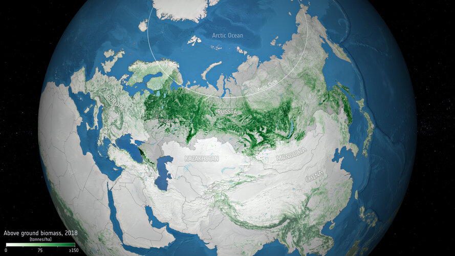
Russia has the largest area of forest on the planet, with more than a fifth of the world's trees. A new study, led by Russian scientists using data from ESA’s Climate Change Initiative, has produced new estimates of biomass contained in Russian forests, and confirms that the vast forested area is storing more carbon than previously estimated.
Kurz: Imagery in Action – získejte nové znalosti v bezplatném kurzu o práci s rastry
4.8.2021 8:20 ARCDATARádi byste si rozšířili své obzory při práci s rastry? Pak využijte možnost přihlásit se do bezplatného kurzu Imagery in Action. Dozvíte se na něm podrobnosti o různých způsobech využití rastrů a uděláte si představu o možnostech aktuálně dostupných aplikací a analytických nástrojů.
Jaká je náplň kurzu?
- Seznámení s ArcGIS Living Atlas of the World, kde najdete data pro své projekty.
- Představení metod dynamického zpracování a vizualizace rastrů.
- Ukázky rastrových analýz v ArcGIS Pro a ArcGIS Online, které pomocí detekce změny území v čase získávají nové prostorové informace.
- Tvorba a sdílení 2D i 3D výstupů určených pro jak pro širokou veřejnost, tak třeba jen pro zainteresované kolegy.
Kurz je zcela zdarma, stačí se pouze registrovat. Výuka začíná ve středu 11. srpna, registrace je však otevřená až do 26. srpna.
Účastníci v rámci kurzu získají volný přístup k ArcGIS Pro, ArcGIS Online, ArcGIS Image Analyst a ArcGIS Image for ArcGIS Online a všem dalším potřebným aplikacím. Po celou dobu konání kurzu budou mít rovněž přístup ke studijním materiálům a cvičením a po dokončení kurzu obdrží certifikát.
Na kurz se můžete přihlásit na webových stránkách Esri.

Bentley Systems Announces Seequent’s Acquisition of Imago
4.8.2021 0:59 GISCafe.com Webcasts-Webinars Integrating Cloud-based Geoscientific Imagery Platform with Geology Data Management and Modeling Tools, Helping Solve Earth, Environment, and Energy …odborný/vrchní referent v oddělení právních vztahů k nemovitostem Katastrálního pracoviště Ústí nad
3.8.2021 20:18 ČÚZK - volná místa Katastrální úřad pro Pardubický kraj - Katastrální pracoviště Ústí nad Orlicí vypisuje výběrové řízení na místo odborný/vrchní referent v oddělení právních vztahů k nemovitostem Katastrálního pracoviště Ústí nadodborný/vrchní referent v oddělení právních vztahů k nemovitostem Katastrálního pracoviště Ústí nad
3.8.2021 20:18 ČÚZK /Urady/Katastralni-urady/Katastralni-urady/Katastralni-urad-pro-Pardubicky-kraj/Uredni-deska/Oznameni-a-jina-uredni-sdeleni/Volna-mista/odborny-vrchni-referent-v-oddeleni-pravnich-vztahuodborný/vrchní referent v oddělení právních vztahů k nemovitostem Katastrálního pracoviště Ústí nad
3.8.2021 20:18 ČÚZK - předpisy a opatření Katastrální úřad pro Pardubický kraj - Katastrální pracoviště Ústí nad Orlicívypisuje výběrové řízení na místo
odborný/vrchní referent v oddělení právních vztahů k nemovitostem Katastrálního pracoviště Ústí nad Orlicí
rada / odborný rada v oddělení aktualizace katastru nemovitostí Katastrálního pracoviště Ústí nad Or
3.8.2021 20:17 ČÚZK /Urady/Katastralni-urady/Katastralni-urady/Katastralni-urad-pro-Pardubicky-kraj/Uredni-deska/Oznameni-a-jina-uredni-sdeleni/Volna-mista/rada-odborny-rada-v-oddeleni-aktualizace-katas-(1)rada / odborný rada v oddělení aktualizace katastru nemovitostí Katastrálního pracoviště Ústí nad Or
3.8.2021 20:17 ČÚZK - předpisy a opatření Katastrální úřad pro Pardubický kraj - Katastrální pracoviště Ústí nad Orlicívypisuje výběrové řízení na místo
rada / odborný rada v oddělení aktualizace katastru nemovitostí Katastrálního pracoviště Ústí nad Orlicí
rada / odborný rada v oddělení aktualizace katastru nemovitostí Katastrálního pracoviště Ústí nad Or
3.8.2021 20:17 ČÚZK - volná místa Katastrální úřad pro Pardubický kraj - Katastrální pracoviště Ústí nad Orlicí vypisuje výběrové řízení na místo rada / odborný rada v oddělení aktualizace katastru nemovitostí Katastrálního pracoviště Ústí nad OrL3Harris Reports Strong Second Quarter 2021 Results
3.8.2021 17:18 GISCafe.com Webcasts-Webinars Revenue$4.7 billion, up 5.0% versus prior year and 6.2% on an organic1 basis
Margins and earnings
Net income margin of 8.8%; adjusted …
Quanergy Demonstrates the Industry First OPA-based Solid State LiDAR with 100 Meter Range
3.8.2021 17:18 GISCafe.com Webcasts-Webinars SUNNYVALE, Calif. — (BUSINESS WIRE) — August 3, 2021 —Quanergy Systems, Inc., a leading provider of OPA-based solid state LiDAR …
CoreLogic Reports Annual Home Price Growth of 17.2% — the Highest Level Since the Late-1970s
3.8.2021 17:18 GISCafe.com Webcasts-Webinars Lack of supply, economic rebound and demographic trends fuel home price surgeAffordability challenges increasingly impact low- and middle-income …