


![]()

zprávy
zdroje zpráv:Euclideon's udCloud Partnership with Microsoft Azure Creates Largest Geospatial Data Platform
2.9.2021 17:24 GISCafe.com Webcasts-Webinars Los Angeles, CA, Sept. 01, 2021 (GLOBE NEWSWIRE) -- An exciting new geospatial industry technology platform, Euclideon udCloud powered by Microsoft …Alabama State University Expands Partnership with Draganfly
2.9.2021 17:24 GISCafe.com Webcasts-Webinars Alabama State University Upgrades to the Latest Draganfly Vital Intelligence Technology and Will Implement Draganfly Varigard Sanitizing Spray Ahead …Luokung Announces eMapgo to Lead Development of Standards for Technical Requirements of Automated Valet Parking Map and Localization
2.9.2021 17:24 GISCafe.com Webcasts-Webinars BEIJING, Sept. 2, 2021 — (PRNewswire) — Luokung Technology Corp. (NASDAQ: LKCO) ("Luokung" or the "Company"), a leading spatial-temporal …Upper Egypt Local Development Program Selects Esri Software for Data-Driven Governance
2.9.2021 17:24 GISCafe.com Webcasts-Webinars Region to Use GIS for Comprehensive, Sustainable Development ProjectsREDLANDS, Calif. — (BUSINESS WIRE) — September 2, 2021 …
BlockApps and Blockchain For Energy Developing Blockchain-Based Seismic Entitlement Platform
2.9.2021 17:24 GISCafe.com Webcasts-Webinars Leading enterprise blockchain STRATO empowers organizations to own and manage their data, increasing traceability and provenance.NEW YORK & …
Luminar Debuts Proactive SafetyTM with On-Road Demonstrations at IAA Munich; Expands Customer Ecosystem with Two Tier 1 Global Automotive Integration Partnerships
2.9.2021 17:24 GISCafe.com Webcasts-Webinars The company released a video comparing current ADAS vs Proactive SafetyTMMUNICH — (BUSINESS WIRE) — September 2, 2021 —
At the …
20210902 - VŘ Metodik bezpečnosti
2.9.2021 15:38 ČÚZK - aktuality v resortu Oznámení o vyhlášení výběrového řízení na obsazení služebního místa odborný rada - Metodik bezpečnosti.20210902 - VŘ Metodik bezpečnosti
2.9.2021 15:38 ČÚZK /Aktuality-resort/2021/20210902-VR-Metodik-bezpecnosti20210902 - VŘ Metodik bezpečnosti
2.9.2021 15:38 ČÚZK - předpisy a opatření Český úřad zeměměřický a katastrální zveřejnil novou aktualitu: Oznámení o vyhlášení výběrového řízení na obsazení služebního místa odborný rada - Metodik bezpečnosti.Odborný rada - Metodik bezpečnosti
2.9.2021 15:25 ČÚZK - předpisy a opatření Český úřad zeměměřický a katastrálnívypisuje výběrové řízení na místo
Odborný rada - Metodik bezpečnosti
Odborný rada - Metodik bezpečnosti
2.9.2021 15:25 ČÚZK /Urady/Cesky-urad-zememericky-a-katastralni/Uredni-deska/Oznameni-a-jina-uredni-sdeleni/Volna-mista/DMS/Odborny-rada-Metodik-bezpecnostiOdborný rada - Metodik bezpečnosti
2.9.2021 15:25 ČÚZK - volná místa Český úřad zeměměřický a katastrální vypisuje výběrové řízení na místo Odborný rada - Metodik bezpečnostiOdborný rada - Agenda veřejných zakázek a smluv odboru informatiky
2.9.2021 15:08 ČÚZK - předpisy a opatření Český úřad zeměměřický a katastrálnívypisuje výběrové řízení na místo
Odborný rada - Agenda veřejných zakázek a smluv odboru informatiky
Odborný rada - Agenda veřejných zakázek a smluv odboru informatiky
2.9.2021 15:08 ČÚZK /Urady/Cesky-urad-zememericky-a-katastralni/Uredni-deska/Oznameni-a-jina-uredni-sdeleni/Volna-mista/DMS/Odborny-rada-Agenda-verejnych-zakazek-a-smluv-odOdborný rada - Agenda veřejných zakázek a smluv odboru informatiky
2.9.2021 15:08 ČÚZK - volná místa Český úřad zeměměřický a katastrální vypisuje výběrové řízení na místo Odborný rada - Agenda veřejných zakázek a smluv odboru informatikyThe augmentation service providers map supporting Galileo is now available!
2.9.2021 11:33 European GNSS Agency
The interactive world map is an online tool to help find information about augmentation service providers that support Galileo. By clicking on each country, the map shows the names of the Galileo-ready providers along with the name and type of service and coverage.
Standard GNSS positioning is often affected by several errors. These errors can be corrected using augmentation services to provide a more accurate and precise position. With augmentation services, users can operate their receivers virtually anywhere on the globe and, by means of receiving data from a control centre, are able to achieve accuracies ranging from meter to centimetre-level, depending on the hardware, platform and application.
Today, there are different augmentation techniques based on the use of a network of ground-based reference or monitoring stations with known locations that enable to calculate corrections (e.g. differential corrections for RTK or clocks and orbits corrections for PPP). These corrections can then be disseminated, for instance, over the internet or satellites.
There is a wide range of GNSS augmentation service providers worldwide, tailored both for professional and consumer markets, some of them utilizing all available satellite constellations (GPS, Galileo, GLONASS, and Beidou ) to ensure consistent and uninterrupted coverage and provide solutions for all classes of GNSS based location services. These solutions can be utilised in a number of markets including: mapping, surveying, construction, agriculture, automotive or aviation, to name a few.
The augmentation service provider map is a thematic map updated on a quarterly basis that provides an easy way to visualize the service providers that are able to operate in each country. Clicking on each country shows the names of the Galileo-ready providers along with the name and type of service and coverage.
You can access the map here.
Media note: This feature can be republished without charge provided the European Union Agency for the Space Programme (EUSPA) is acknowledged as the source at the top or the bottom of the story. You must request permission before you use any of the photographs on the site. If you republish, we would be grateful if you could link back to the EUSPA website (http://www.euspa.europa.eu).
The augmentation service providers map supporting Galileo is now available!
2.9.2021 11:33 European GNSS AgencyThe interactive world map is an online tool to help find information about augmentation service providers that support Galileo. By clicking on each country, the map shows the names of the Galileo-ready providers along with the name and type of service and coverage.
Standard GNSS positioning is often affected by several errors. These errors can be corrected using augmentation services to provide a more accurate and precise position. With augmentation services, users can operate their receivers virtually anywhere on the globe and, by means of receiving data from a control centre, are able to achieve accuracies ranging from meter to centimetre-level, depending on the hardware, platform and application.
Today, there are different augmentation techniques based on the use of a network of ground-based reference or monitoring stations with known locations that enable to calculate corrections (e.g. differential corrections for RTK or clocks and orbits corrections for PPP). These corrections can then be disseminated, for instance, over the internet or satellites.
There is a wide range of GNSS augmentation service providers worldwide, tailored both for professional and consumer markets, some of them utilizing all available satellite constellations (GPS, Galileo, GLONASS, and Beidou ) to ensure consistent and uninterrupted coverage and provide solutions for all classes of GNSS based location services. These solutions can be utilised in a number of markets including: mapping, surveying, construction, agriculture, automotive or aviation, to name a few.
The augmentation service provider map is a thematic map updated on a quarterly basis that provides an easy way to visualize the service providers that are able to operate in each country. Clicking on each country shows the names of the Galileo-ready providers along with the name and type of service and coverage.
You can access the map here.
Media note: This feature can be republished without charge provided the European Union Agency for the Space Programme (EUSPA) is acknowledged as the source at the top or the bottom of the story. You must request permission before you use any of the photographs on the site. If you republish, we would be grateful if you could link back to the EUSPA website (http://www.euspa.europa.eu).
20210902_Odborný / vrchní referent oddělení dokumentace KN
2.9.2021 11:27 ČÚZK /Urady/Katastralni-urady/Katastralni-urady/Katastralni-urad-pro-Stredocesky-kraj/Katastralni-pracoviste/KP-Benesov/O-uradu/Aktuality/20210113_odborny-rada,-reditel-Katastralniho-p-(1)20210902_Odborný / vrchní referent oddělení dokumentace KN
2.9.2021 11:27 ČÚZK - předpisy a opatření Katastrální úřad pro Středočeský kraj - Katastrální pracoviště Benešov Vyhlášení výběrového řízení: Odborný / vrchní referent oddělení dokumentace KN V části "Úřední deska", v sekci "Oznámení a jiná úřední sdělení" bylo vystaveno "Oznámení o vyhlášení výběrového řízení na obsazení služebního místa Odborný / vrchní referent oddělení dokumentace KN"Odborný / vrchní referent oddělení dokumentace KN
2.9.2021 11:25 ČÚZK - předpisy a opatření Katastrální úřad pro Středočeský kraj - Katastrální pracoviště Benešovvypisuje výběrové řízení na místo Odborný / vrchní referent oddělení dokumentace KN
Odborný / vrchní referent oddělení dokumentace KN
Odborný / vrchní referent oddělení dokumentace KN
2.9.2021 11:25 ČÚZK - volná místa Katastrální úřad pro Středočeský kraj - Katastrální pracoviště Benešov vypisuje výběrové řízení na místo Odborný / vrchní referent oddělení dokumentace KN20210902_Odborný rada – metodik katastru nemovitostí v oddělení metodiky a kontroly Kat. úřadu SČK
2.9.2021 10:36 ČÚZK - předpisy a opatření Katastrální úřad pro Středočeský kraj Vyhlášení výběrového řízení: Odborný rada – metodik katastru nemovitostí v oddělení metodiky a kontroly Katastrálního úřadu pro Středočeský kraj V části "Úřední deska", v sekci "Oznámení a jiná úřední sdělení" bylo vystaveno "Oznámení o vyhlášení výběrového řízení na obsazení služebního místa Odborný rada – metodik katastru nemovitostí v oddělení metodiky a kontroly Katastrálního úřadu pro Středočeský kraj"20210902_Odborný rada – metodik katastru nemovitostí v oddělení metodiky a kontroly Kat. úřadu SČK
2.9.2021 10:36 ČÚZK /Urady/Katastralni-urady/Katastralni-urady/Katastralni-urad-pro-Stredocesky-kraj/O-uradu/Aktuality/20210113_odborny-rada,-reditel-Katastralniho-p-(3)Odborný rada – metodik katastru nemovitostí v oddělení metodiky a kontroly Katastrálního úřadu pro S
2.9.2021 10:35 ČÚZK /Urady/Katastralni-urady/Katastralni-urady/Katastralni-urad-pro-Stredocesky-kraj/Uredni-deska/Oznameni-a-jina-uredni-sdeleni/Volna-mista/Odborny-rada-–-metodik-katastru-nemovitosti-v-oddeOdborný rada – metodik katastru nemovitostí v oddělení metodiky a kontroly Katastrálního úřadu pro S
2.9.2021 10:35 ČÚZK - předpisy a opatření Katastrální úřad pro Středočeský krajvypisuje výběrové řízení na místo Odborný rada – metodik katastru nemovitostí v oddělení metodiky a kontroly Katastrálního úřadu pro Středočeský kraj
Odborný rada – metodik katastru nemovitostí v oddělení metodiky a kontroly Katastrálního úřadu pro Středočeský kraj
Odborný rada – metodik katastru nemovitostí v oddělení metodiky a kontroly Katastrálního úřadu pro S
2.9.2021 10:35 ČÚZK - volná místa Katastrální úřad pro Středočeský kraj vypisuje výběrové řízení na místo Odborný rada – metodik katastru nemovitostí v oddělení metodiky a kontroly Katastrálního úřadu pro S20210902_Rada / odborný rada – interní auditor Katastrálního úřadu pro Středočeský kraj
2.9.2021 10:18 ČÚZK - předpisy a opatření Katastrální úřad pro Středočeský kraj Vyhlášení výběrového řízení: Rada / odborný rada – interní auditor Katastrálního úřadu pro Středočeský kraj V části "Úřední deska", v sekci "Oznámení a jiná úřední sdělení" bylo vystaveno "Oznámení o vyhlášení výběrového řízení na obsazení služebního místa Rada / odborný rada – interní auditor Katastrálního úřadu pro Středočeský kraj"20210902_Rada / odborný rada – interní auditor Katastrálního úřadu pro Středočeský kraj
2.9.2021 10:18 ČÚZK /Urady/Katastralni-urady/Katastralni-urady/Katastralni-urad-pro-Stredocesky-kraj/O-uradu/Aktuality/20210113_odborny-rada,-reditel-Katastralniho-p-(1)20210902_Rada / odborný rada – interní auditor Katastrálního úřadu pro Středočeský kraj
2.9.2021 10:18 ČÚZK - předpisy a opatření Katastrální úřad pro Středočeský kraj Vyhlášení výběrového řízení: Rada / odborný rada – interní auditor Katastrálního úřadu pro Středočeský kraj V části "Úřední deska", v sekci "Oznámení a jiná úřední sdělení" bylo vystaveno "Oznámení o vyhlášení výběrového řízení na obsazení služebního místa Odborný referent oddělení právních vztahů k nemovitostem"Meteosat Third Generation takes major step towards its first launch
2.9.2021 9:30 ESA Observing the Earth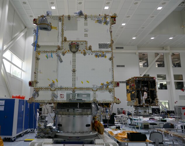
After many technical and programmatic challenges, the first satellite of the next generation of the Meteosat family has taken a major step towards its first flight, currently scheduled for launch in autumn 2022.
Uzavření kontaktního místa
2.9.2021 9:21 ČÚZK - předpisy a opatření Katastrální úřad pro Vysočinu - Katastrální pracoviště Žďár nad Sázavou zveřejnil novou aktualitu: Katastrální úřad pro Vysočinu, Katastrální pracoviště Žďár nad Sázavou oznamuje, že dne 27. 9. 2021 Kontaktní místo Bystřice nad Pernštejnem bude z provozních důvodů uzavřeno.V případě potřeby se obracejte na podatelnu Katastrálního pracoviště Žďár nad Sázavou, se sídlem Strojírenská 8, 591 27 Žďár nad Sázavou.
Uzavření kontaktního místa
2.9.2021 9:21 ČÚZK /Urady/Katastralni-urady/Katastralni-urady/Katastralni-urad-pro-Vysocinu/Katastralni-pracoviste/KP-Zdar-nad-Sazavou/O-uradu/Aktuality/Uzavreni-kontaktniho-mistaUzavření kontaktního místa
2.9.2021 9:21 ČÚZK - předpisy a opatření Katastrální úřad pro Vysočinu - Katastrální pracoviště Žďár nad Sázavou zveřejnil novou aktualitu: Katastrální úřad pro Vysočinu, Katastrální pracoviště Žďár nad Sázavou oznamuje, že dne 27. 9. 2021 Kontaktní místo Bystřice nad Pernštejnem bude z provozních důvodů uzavřeno.V případě potřeby se obracejte na podatelnu Katastrálního pracoviště Žďár nad Sázavou, se sídlem Strojírenská 8, 591 27 Žďár nad Sázavou.
Platy úředníků
2.9.2021 6:21 ZeměměřičOd roku 2018 existuje web Platyuredniku.cz, na kterém si můžete najít, jaký mají plat a odměny vedoucí pracovníci z více než 360 institucí a úřadů. Aktuálně byla zveřejněna data za rok 2020. V informacích o projektu je uvedeno, že důležitým cílem je napomoci zlepšit transparentnost veřejné správy a zvýšit tak její kvalitu. Kromě principiálního rozměru – totiž toho, že občanům […]
The post Platy úředníků appeared first on Zeměměřič.
Další zkoušky odborné způsobilosti (ÚOZI) budou v druhé polovině září
1.9.2021 23:18 ZeměměřičČeský úřad zeměměřický a katastrální oznámil, že zkoušky odborné způsobilosti k udělení úředního oprávnění pro ověřování výsledků zeměměřických činností podle § 13 odst. 1 písm. a) až c) zákona č. 200/1994 Sb., o zeměměřictví, ve znění pozdějších předpisů, se budou konat dne 21. září 2021 v 6. patře budovy zeměměřických a katastrálních úřadů, Praha 8, Pod sídlištěm 9. Písemnou žádost o udělení úředního oprávnění, doplněnou […]
The post Další zkoušky odborné způsobilosti (ÚOZI) budou v druhé polovině září appeared first on Zeměměřič.
Podzimní kolo výběrového řízení na studijní pobyty Erasmus+ v LS 2022 [Katedra aplikované geoinformatiky a kartografie, byTopic]
1.9.2021 22:30 Katedra aplikované geoinformatiky a kartografie Přf UK Vzhledem k dostatečnému množství nevyčerpaných finančních prostředku na studentské výjezdy v rámci programu ERASMUS+ je otevřeno dodatečné (podzimní) kolo výběrových řízení.CoreLogic Estimates $27 Billion to $40 Billion in Insured and Uninsured Losses from Hurricane Ida Wind, Storm Surge and Inland Flooding
1.9.2021 21:53 GISCafe.com Webcasts-Webinars —Uninsured losses could total $19 billion in Louisiana, Mississippi and Alabama—IRVINE, Calif. — (BUSINESS WIRE) — September 1, 2021 …
Planet Expands Leadership Team with Key Product and Corporate Development Hires
1.9.2021 17:10 GISCafe.com Webcasts-Webinars Nate Gonzalez Appointed VP of Platform Product and Ali Jafari Appointed VP of Corporate DevelopmentNew Hires Bring Invaluable High-Growth Public …
Red Cat Holdings Closes Acquisition of Teal Drones
1.9.2021 17:10 GISCafe.com Webcasts-Webinars Expansion into military sector represents compelling growth opportunityHUMACAO, Puerto Rico, Sept. 1, 2021 — (PRNewswire) — Red Cat …
Cepton to Showcase Automotive Grade Lidars at IAA Mobility and AutoSens
1.9.2021 17:10 GISCafe.com Webcasts-Webinars Vista®-X90 makes debut in Europe at upcoming tradeshowsSAN JOSE, Calif. — (BUSINESS WIRE) — September 1, 2021 —
Cepton, an …
BlackSky Secures Investment from Palantir and Enters into Multi-Year Strategic Partnership Following Successful Pilot Project
1.9.2021 17:10 GISCafe.com Webcasts-Webinars Collaboration to Expand Delivery of High-Resolution Imagery and Deep AnalyticsHERNDON, Va. — (BUSINESS WIRE) — September 1, 2021 …
AgEagle Aerial Systems CEO, Brandon Torres Declet, to Serve as Keynote Speaker at Commercial UAV Expo in Las Vegas on September 8, 2021
1.9.2021 17:10 GISCafe.com Webcasts-Webinars WICHITA, Kan., Sept. 01, 2021 (GLOBE NEWSWIRE) -- AgEagle Aerial Systems Inc. (NYSE American: UAVS) (“AgEagle” or the “Company”), an …EAASI Elects Executive Committee to Promote Aerial Surveying in Europe
1.9.2021 16:58 GISCafe.com Webcasts-Webinars Brussels, 01 September 2021 - The European Association of Aerial Surveying Industries (EAASI) has extended the mandate of the Executive Committee to …výběrové řízení na KP Jihlava
1.9.2021 12:37 ČÚZK - předpisy a opatření Katastrální úřad pro Vysočinu zveřejnil novou aktualitu: Oznámení o vyhlášení výběrového řízení na služební místo vrchní referent/rada v oddělení aktualizace KN II Katastrálního pracoviště Jihlava.výběrové řízení na KP Jihlava
1.9.2021 12:37 ČÚZK /Urady/Katastralni-urady/Katastralni-urady/Katastralni-urad-pro-Vysocinu/O-uradu/Aktuality/vyberove-rizeni-na-KP-JihlavaUpozornění
1.9.2021 11:32 ČÚZK /Urady/Zememericke-a-katastralni-inspektoraty/Zememericke-a-katastralni-inspektoraty/Zememericky-a-katastralni-inspektorat-v-CB/O-uradu/Aktuality/UpozorneniUpozornění
1.9.2021 11:32 ČÚZK - předpisy a opatření Zeměměřický a katastrální inspektorát v Českých Budějovicích zveřejnil novou aktualitu: Upozorňujeme klienty, že dne 2.9.2021 bude budova Katastrálního úřadu pro Jihočeský kraj, Lidická tř. 124/11, České Budějovice, ve které sídlí ZKI, z provozních důvodů uzavřena.Oznámení o vyhlášení výběrového řízení na služební místo vrchní referent/rada v oddělení aktualizace
1.9.2021 11:28 ČÚZK - volná místa Katastrální úřad pro Vysočinu Katastrální pracoviště Jihlava vypisuje výběrové řízení na místo Oznámení o vyhlášení výběrového řízení na služební místo vrchní referent/rada v oddělení aktualizaceOznámení o vyhlášení výběrového řízení na služební místo vrchní referent/rada v oddělení aktualizace
1.9.2021 11:28 ČÚZK /Urady/Katastralni-urady/Katastralni-urady/Katastralni-urad-pro-Vysocinu/Uredni-deska/Oznameni-a-jina-uredni-sdeleni/Volna-mista/DMS/Oznameni-o-vyhlaseni-vyberoveho-rizeni-na-sluzebniOznámení o vyhlášení výběrového řízení na služební místo vrchní referent/rada v oddělení aktualizace
1.9.2021 11:28 ČÚZK - předpisy a opatření Katastrální úřad pro Vysočinu Katastrální pracoviště Jihlavavypisuje výběrové řízení na místo
Oznámení o vyhlášení výběrového řízení na služební místo vrchní referent/rada v oddělení aktualizace KN II Katastrálního pracoviště Jihlava na Katastrálním úřadu pro Vysočinu
Odborný referent v oddělení dokumentace KN na Katastrálním pracovišti Vyškov
1.9.2021 10:43 ČÚZK - volná místa Katastrální úřad pro Jihomoravský kraj Katastrální pracoviště Vyškov vypisuje výběrové řízení na místo Odborný referent v oddělení dokumentace KN na Katastrálním pracovišti VyškovOdborný referent v oddělení dokumentace KN na Katastrálním pracovišti Vyškov
1.9.2021 10:43 ČÚZK /Urady/Katastralni-urady/Katastralni-urady/Katastralni-urad-pro-Jihomoravsky-kraj/Uredni-deska/Oznameni-a-jina-uredni-sdeleni/Volna-mista/DMS/Odborny-referent-v-oddeleni-dokumentace-KN-na-KataOdborný referent v oddělení dokumentace KN na Katastrálním pracovišti Vyškov
1.9.2021 10:43 ČÚZK - předpisy a opatření Katastrální úřad pro Jihomoravský kraj Katastrální pracoviště Vyškovvypisuje výběrové řízení na místo
Odborný referent v oddělení dokumentace KN na Katastrálním pracovišti Vyškov
#myEUspace competition goes live and invites you to disrupt Europe’s technological tomorrow! Are you ready for it?
1.9.2021 10:31 European GNSS Agency.")
It is official! Following the success of the previous innovation competitions, the European Union Agency for the Space Programme (EUSPA) announces today #myEUSpace! The EUSPA-led competition targets innovators and entrepreneurs ready to develop and commercialise innovative solutions that leverage EU space data and services. It goes beyond the current space-applications horizon, fusing and testing new technologies in location-based services, smart mobility, smart agriculture, geomatics, and for the first time, quantum technologies.
Free and easily accessible EU Space data have allowed the creation of original and iinnovative projects and services in sectors such as IoT, precision farming, robotics and drones among others. Accurate positioning offered by Galileo, data and high-resolution imagery from Copernicus paired with the use of quantum technology will set European innovation on a new trajectory.
With a prize pool of € 1 million and over 50 awards up for grabs, #myEUspace competition - part of the European Commission Cassini initiative will help innovators develop and market disruptive, space-based commercial solutions able to respond to emerging societal needs and serve various domains such as smart mobility and agriculture, health and leisure, and logistics and smart cities, among others.
The competition consists of two independent and parallel tracks, each one with a list of goals and deliverables.
Track 1 - From Idea to Prototype/customer validation – aims to turn a theoretical idea into a product prototype/beta version. Track 2 - From Prototype to Product /Market entry – aims to develop a prototype or beta idea into a Minimum Viable Product (MVP).
The competition looks at solutions where the use and integration of EU Space data and services can disrupt the following six thematic areas:
-
Move Me Smart: Smart mobility solutions across all transportation modes to improve efficiency and sustainability and increase safety.
-
Space Up My Life: Consumer solutions such as mobile applications and any other solution using space data for health, gaming, sports, leisure, tourism and everyday life.
-
Our Green Planet: Innovative solutions addressing environmental challenges, sustainable life, consumption and production.
-
Map My World: Innovative surveying solutions to shape the future of geomatics, rural planning and smart cities by design.
-
Farming by Satellite: Technological solutions to manage the variability of agricultural production, improve crop yield, reduce environmental impact and optimize the food chain.
-
Dive in Quantum: Innovative solutions applying quantum technologies (computing, sensing, simulation, encryption etc.) enhancing space downstream applications.
Sounds interesting? Find out how to win here!
Media note: This feature can be republished without charge provided the European Union Agency for the Space Programme (EUSPA) is acknowledged as the source at the top or the bottom of the story. You must request permission before you use any of the photographs on the site. If you republish, we would be grateful if you could link back to the EUSPA website (http://www.euspa.europa.eu).
#myEUspace competition goes live and invites you to disrupt Europe’s technological tomorrow! Are you ready for it?
1.9.2021 10:31 European GNSS AgencyIt is official! Following the success of the previous innovation competitions, the European Union Agency for the Space Programme (EUSPA) announces today #myEUSpace! The EUSPA-led competition targets innovators and entrepreneurs ready to develop and commercialise innovative solutions that leverage EU space data and services. It goes beyond the current space-applications horizon, fusing and testing new technologies in location-based services, smart mobility, smart agriculture, geomatics, and for the first time, quantum technologies.
Free and easily accessible EU Space data have allowed the creation of original and innovative projects and services in sectors such as IoT, precision farming, robotics and drones among others. Accurate positioning offered by Galileo, data and high-resolution imagery from Copernicus paired with the use of quantum technology will set European innovation on a new trajectory.
With a prize pool of € 1 million and over 50 awards up for grabs, #myEUspace competition - part of the European Commission Cassini initiative will help innovators develop and market disruptive, space-based commercial solutions able to respond to emerging societal needs and serve various domains such as smart mobility and agriculture, health and leisure, and logistics and smart cities, among others.
The competition consists of two independent and parallel tracks, each one with a list of goals and deliverables.
Track 1 - From Idea to Prototype/customer validation – aims to turn a theoretical idea into a product prototype/beta version. Track 2 - From Prototype to Product /Market entry – aims to develop a prototype or beta idea into a Minimum Viable Product (MVP).
The competition looks at solutions where the use and integration of EU Space data and services can disrupt the following six thematic areas:
-
Move Me Smart: Smart mobility solutions across all transportation modes to improve efficiency and sustainability and increase safety.
-
Space Up My Life: Consumer solutions such as mobile applications and any other solution using space data for health, gaming, sports, leisure, tourism and everyday life.
-
Our Green Planet: Innovative solutions addressing environmental challenges, sustainable life, consumption and production.
-
Map My World: Innovative surveying solutions to shape the future of geomatics, rural planning and smart cities by design.
-
Farming by Satellite: Technological solutions to manage the variability of agricultural production, improve crop yield, reduce environmental impact and optimize the food chain.
-
Dive in Quantum: Innovative solutions applying quantum technologies (computing, sensing, simulation, encryption etc.) enhancing space downstream applications.
Sounds interesting? Find out how to win here!
Media note: This feature can be republished without charge provided the European Union Agency for the Space Programme (EUSPA) is acknowledged as the source at the top or the bottom of the story. You must request permission before you use any of the photographs on the site. If you republish, we would be grateful if you could link back to the EUSPA website (http://www.euspa.europa.eu).
#myEUspace competition goes lives and invites you to disrupt Europe’s technological tomorrow! Are you ready for it?
1.9.2021 10:31 European GNSS AgencyIt is official! Following the success of the previous innovation competitions, the European Union Agency for the Space Programme (EUSPA) announces today #myEUSpace! The EUSPA-led competition targets innovators and entrepreneurs ready to develop and commercialise innovative solutions that leverage EU space data and services. It goes beyond the current space-applications horizon, fusing and testing new technologies in location-based services, smart mobility, smart agriculture, geomatics, and for the first time, quantum technologies.
Free and easily accessible EU Space data have allowed the creation of original and iinnovative projects and services in sectors such as IoT, precision farming, robotics and drones among others. Accurate positioning offered by Galileo, data and high-resolution imagery from Copernicus paired with the use of quantum technology will set European innovation on a new trajectory.
With a prize pool of € 1 million and over 50 awards up for grabs, #myEUspace competition - part of the European Commission Cassini initiative will help innovators develop and market disruptive, space-based commercial solutions able to respond to emerging societal needs and serve various domains such as smart mobility and agriculture, health and leisure, and logistics and smart cities, among others.
The competition consists of two independent and parallel tracks, each one with a list of goals and deliverables.
Track 1 - From Idea to Prototype/customer validation – aims to turn a theoretical idea into a product prototype/beta version. Track 2 - From Prototype to Product /Market entry – aims to develop a prototype or beta idea into a Minimum Viable Product (MVP).
The competition looks at solutions where the use and integration of EU Space data and services can disrupt the following six thematic areas:
-
Move Me Smart: Smart mobility solutions across all transportation modes to improve efficiency and sustainability and increase safety.
-
Space Up My Life: Consumer solutions such as mobile applications and any other solution using space data for health, gaming, sports, leisure, tourism and everyday life.
-
Our Green Planet: Innovative solutions addressing environmental challenges, sustainable life, consumption and production.
-
Map My World: Innovative surveying solutions to shape the future of geomatics, rural planning and smart cities by design.
-
Farming by Satellite: Technological solutions to manage the variability of agricultural production, improve crop yield, reduce environmental impact and optimize the food chain.
-
Dive in Quantum: Innovative solutions applying quantum technologies (computing, sensing, simulation, encryption etc.) enhancing space downstream applications.
Sounds interesting? Find out how to win here!
Media note: This feature can be republished without charge provided the European Union Agency for the Space Programme (EUSPA) is acknowledged as the source at the top or the bottom of the story. You must request permission before you use any of the photographs on the site. If you republish, we would be grateful if you could link back to the EUSPA website (http://www.euspa.europa.eu).
#myEUspace competition goes live and invites you to disrupt Europe’s technological tomorrow! Are you ready for it?
1.9.2021 10:31 European GNSS AgencyIt is official! Following the success of the previous innovation competitions, the European Union Agency for the Space Programme (EUSPA) announces today #myEUSpace! The EUSPA-led competition targets innovators and entrepreneurs ready to develop and commercialise innovative solutions that leverage EU space data and services. It goes beyond the current space-applications horizon, fusing and testing new technologies in location-based services, smart mobility, smart agriculture, geomatics, and for the first time, quantum technologies.
Free and easily accessible EU Space data have allowed the creation of original and iinnovative projects and services in sectors such as IoT, precision farming, robotics and drones among others. Accurate positioning offered by Galileo, data and high-resolution imagery from Copernicus paired with the use of quantum technology will set European innovation on a new trajectory.
With a prize pool of € 1 million and over 50 awards up for grabs, #myEUspace competition - part of the European Commission Cassini initiative will help innovators develop and market disruptive, space-based commercial solutions able to respond to emerging societal needs and serve various domains such as smart mobility and agriculture, health and leisure, and logistics and smart cities, among others.
The competition consists of two independent and parallel tracks, each one with a list of goals and deliverables.
Track 1 - From Idea to Prototype/customer validation – aims to turn a theoretical idea into a product prototype/beta version. Track 2 - From Prototype to Product /Market entry – aims to develop a prototype or beta idea into a Minimum Viable Product (MVP).
The competition looks at solutions where the use and integration of EU Space data and services can disrupt the following six thematic areas:
-
Move Me Smart: Smart mobility solutions across all transportation modes to improve efficiency and sustainability and increase safety.
-
Space Up My Life: Consumer solutions such as mobile applications and any other solution using space data for health, gaming, sports, leisure, tourism and everyday life.
-
Our Green Planet: Innovative solutions addressing environmental challenges, sustainable life, consumption and production.
-
Map My World: Innovative surveying solutions to shape the future of geomatics, rural planning and smart cities by design.
-
Farming by Satellite: Technological solutions to manage the variability of agricultural production, improve crop yield, reduce environmental impact and optimize the food chain.
-
Dive in Quantum: Innovative solutions applying quantum technologies (computing, sensing, simulation, encryption etc.) enhancing space downstream applications.
Sounds interesting? Find out how to win here!
Media note: This feature can be republished without charge provided the European Union Agency for the Space Programme (EUSPA) is acknowledged as the source at the top or the bottom of the story. You must request permission before you use any of the photographs on the site. If you republish, we would be grateful if you could link back to the EUSPA website (http://www.euspa.europa.eu).
Oznámení o výběru zástupu na služební místo
1.9.2021 8:14 ČÚZK - předpisy a opatření Katastrální úřad pro Plzeňský kraj - Katastrální pracoviště Rokycany zveřejnil novou aktualitu: Oznámení o výběru zástupu na služební místo odborný/vrchní referent – návrh zápisu v katastru NZK1302, KP RokycanyOznámení o výběru zástupu na služební místo
1.9.2021 8:03 ČÚZK /Urady/Katastralni-urady/Katastralni-urady/Katastralni-urad-pro-Plzensky-kraj/Uredni-deska/Oznameni-a-jina-uredni-sdeleni/Volna-mista/DMS/Oznameni-o-vyberu-zastupu-na-sluzebni-mistoOznámení o výběru zástupu na služební místo
1.9.2021 8:03 ČÚZK - volná místa Katastrální úřad pro Plzeňský kraj Katastrální pracoviště Rokycany vypisuje výběrové řízení na místo Oznámení o výběru zástupu na služební místoOznámení o výběru zástupu na služební místo
1.9.2021 8:03 ČÚZK - předpisy a opatření Katastrální úřad pro Plzeňský kraj Katastrální pracoviště Rokycanyvypisuje výběrové řízení na místo
Oznámení o výběru zástupu na služební místo
Inspekce 100 kilometrů elektrického vedení s pomocí BVLOS UAS od SwissDrones
1.9.2021 6:33 GeoBusinessŠvýcarský výrobce bezpilotních leteckých systémů SwissDrones dokončil v Belgii se svým bezpilotním vrtulníkem SDO 50 V2 VTOL první komerční inspekci elektrického vedení metodou BVLOS (beyond visual line of sight), tedy „mimo vizuální viditelnost“. Délka letu byla více než 100 kilometrů v rámci jediného letu po dobu dvou hodin. Bezpilotní systém SDO 50 V2 UAS od […]
The post Inspekce 100 kilometrů elektrického vedení s pomocí BVLOS UAS od SwissDrones appeared first on GeoBusiness.
Carbonix Partners with Robotic Skies to Advance Global Field Support
1.9.2021 2:31 GISCafe.com Webcasts-Webinars Robotic Skies, Inc, a global marketplace for commercial drone maintenance services, and Carbonix, a leading Australian designer, manufacturer, and …Knihovna geografie je od 1.9.2021 opět otevřena! [Knihovna geografie, byTopic]
1.9.2021 0:00 Katedra aplikované geoinformatiky a kartografie Přf UK Knihovny Univerzity Karlovy, včetně Knihovny geografie, dnes zahájily provoz v nové knihovní platformě Alma. Její součástí je také nová podoba centrálního vyhledávače UKAŽ (ukaz.cuni.cz), který nahrazuje a sjednocuje funkce původního knihovního katalogu (CKIS), linkserveru SFX a služby Ebsco Discovery Service.Knihovna geografie je od 1.9.2021 opět otevřena! [Knihovna geografie, byTopic]
1.9.2021 0:00 Katedra aplikované geoinformatiky a kartografie Přf UK Po letní přestávce, během které došlo k rekonstrukci podlah knihovny a především k migraci na nový knihovnický systém ALMA, Vás opět rádi přivítáme v naší knihovně!20210831 - VŘ Správce DMVS
31.8.2021 21:42 ČÚZK - předpisy a opatření Český úřad zeměměřický a katastrální zveřejnil novou aktualitu: Oznámení o vyhlášení výběrového řízení na obsazení služebního místa rada/odborný rada - Správce DMVS.20210831 - VŘ Správce DMVS
31.8.2021 21:42 ČÚZK - aktuality v resortu Oznámení o vyhlášení výběrového řízení na obsazení služebního místa rada/odborný rada - Správce DMVS.Geo Connect Asia 2022 launches with focus on addressing key regional challenges
31.8.2021 20:29 GISCafe.com Webcasts-Webinars Southeast Asia's geospatial & location intelligence event for government, enterprise and the not-for-profit sectors is set for its second …Fulcrum introduces Fulcrum Connect integrations program to integrate the field with the back office
31.8.2021 20:26 GISCafe.com Webcasts-Webinars Fulcrum Connect integrations library maximizes the value of data collected in the field by extending it to enterprise systems, business processes and …Rada/odborný rada - Správce DMVS
31.8.2021 18:32 ČÚZK - předpisy a opatření Český úřad zeměměřický a katastrálnívypisuje výběrové řízení na místo
Rada/odborný rada - Správce DMVS
Odborný rada - Řízení KÚ - správa a vedení
31.8.2021 18:24 ČÚZK /Urady/Cesky-urad-zememericky-a-katastralni/Uredni-deska/Oznameni-a-jina-uredni-sdeleni/Volna-mista/DMS/Odborny-rada-Rizeni-KU-sprava-a-vedeniOdborný rada - Řízení KÚ - správa a vedení
31.8.2021 18:24 ČÚZK - předpisy a opatření Český úřad zeměměřický a katastrálnívypisuje výběrové řízení na místo
Odborný rada - Řízení KÚ - správa a vedení
Odborný rada - Řízení KÚ - správa a vedení
31.8.2021 18:24 ČÚZK - volná místa Český úřad zeměměřický a katastrální vypisuje výběrové řízení na místo Odborný rada - Řízení KÚ - správa a vedeníEsri Releases ArcGIS Pro Book Updated for Version 2.8
31.8.2021 18:07 GISCafe.com Webcasts-Webinars Guide Includes the Latest ArcGIS Pro Tools and Workflows with Proven Instructional StrategiesREDLANDS, Calif. — (BUSINESS WIRE) — August …
S&P CoreLogic Case-Shiller Index Shows Annual Home Price Gain Topped 18.6% In June
31.8.2021 18:07 GISCafe.com Webcasts-Webinars NEW YORK, Aug. 31, 2021 — (PRNewswire) — S&P Dow Jones Indices (S&P DJI) today released the latest results for the S&P …Eye-bot and VEERUM Team to Deliver a Comprehensive 3D Visualization of Critical Assets in Oil & Gas
31.8.2021 18:07 GISCafe.com Webcasts-Webinars PITTSBURGH, Aug. 31, 2021 — (PRNewswire) — Eye-bot Aerial Solutions (Eye-bot) & VEERUM recently announced a Premier Partnership to …Velodyne Lidar and MOV.AI Partner to Provide Autonomous Solutions for Industrial and E-Commerce Robotics
31.8.2021 16:24 GISCafe.com Webcasts-Webinars SAN JOSE, Calif. & TEL AVIV, Israel — (BUSINESS WIRE) — August 31, 2021 —Velodyne Lidar, Inc. (Nasdaq: VLDR, VLDRW) and …
Wipro and HERE partner to provide location-based services and analytics for customers globally
31.8.2021 16:24 GISCafe.com Webcasts-Webinars Location planning for smart metering and field service management are key areas of collaboration HERE Tracking to enable monitoring and tracking …Jak používat drony pro ochranu životního prostředí
31.8.2021 15:49 GeoBusinessČeská asociace pro geoinformace pořádá ve spolupráci s Univerzitou Palackého v Olomouci a s VŠB – TU Ostrava akreditovaný kurz, nazvaný „Bezpilotní letecké prostředky (UAV) pro ochranu životního prostředí“. Kurz je určen především pro úředníky a vedoucí úředníky územně samosprávných celků, pracující v oblasti ochrany životního prostředí. Kurz ale mohou absolvovat i další zájemci. U […]
The post Jak používat drony pro ochranu životního prostředí appeared first on GeoBusiness.
Výběrové řízení - odborný referent KT
31.8.2021 12:54 ČÚZK - předpisy a opatření Český úřad zeměměřický a katastrální - Katastrální pracoviště Klatovy zveřejnil novou aktualitu: Ředitelka KÚ pro Plzeňský kraj vyhlašuje výběrové řízení na služební místo odborný referent/vrchní referent – OKO0609 - KP KlatovyVýběrové řízení - odborný referent KT
31.8.2021 12:54 ČÚZK - předpisy a opatření Katastrální úřad pro Plzeňský kraj - Katastrální pracoviště Klatovy zveřejnil novou aktualitu: Ředitelka KÚ pro Plzeňský kraj vyhlašuje výběrové řízení na služební místo odborný referent/vrchní referent – OKO0609 - KP KlatovyVýběrové řízení - odborný referent KT
31.8.2021 12:54 ČÚZK /Urady/Katastralni-urady/Katastralni-urady/Katastralni-urad-pro-Plzensky-kraj/O-uradu/Aktuality/Vyberove-rizeni-odborny-referent-KTVýběrové řízení - odborný referent KT
31.8.2021 12:54 ČÚZK - předpisy a opatření Katastrální úřad pro Plzeňský kraj - Katastrální pracoviště Klatovy zveřejnil novou aktualitu: Ředitelka KÚ pro Plzeňský kraj vyhlašuje výběrové řízení na služební místo odborný referent/vrchní referent – OKO0609 - KP KlatovyInteraktivní ÚAP 2020 pro ORP 2020
31.8.2021 12:45 Statutární město Ústí nad Labem Na mapovém portále města Ústí nad Labem (odkaz: https://www.usti-nad-labem.cz/mapovy-portal/mapove-aplikace.html ) byla zveřejněna a kompletně doplněna mapová aplikace pro Územně analytické podklady ORP 2020 (5. úplná aktualizace). Mapová aplikace ÚAP 2016 (4. úplná aktualizace) byla ponechána weřejnosti k dispozici a bude stále plně funkční. Více o ÚAP ORP Ústí nad Labem (např. nové doplňující informační mapy a kartogramy v pdf podobě) naleznete na mapovém portále v sekci Územně analytické podklady, odkaz zde: https://www.usti-nad-labem.cz/mapovy-portal/uzemne-analyticke-podklady.htmlReferent/ka zeměměřictví a katastru nemovitostí
31.8.2021 11:53 Zeměměřický úřad Zeměměřický úřadvypisuje výběrové řízení na místo
Referent/ka zeměměřictví a katastru nemovitostí
Referent/ka zeměměřictví a katastru nemovitostí
31.8.2021 11:53 ČÚZK - volná místa Zeměměřický úřad vypisuje výběrové řízení na místo Referent/ka zeměměřictví a katastru nemovitostíReferent/ka zeměměřictví a katastru nemovitostí
31.8.2021 11:53 ČÚZK /Urady/Zememericky-urad/Uredni-deska/Oznameni-a-jina-uredni-sdeleni/Volna-mista/Referent-ka-zememerictvi-a-katastru-nemovitosti-(3Referent/ka zeměměřictví a katastru nemovitostí
31.8.2021 11:53 ČÚZK - předpisy a opatření Zeměměřický úřadvypisuje výběrové řízení na místo
Referent/ka zeměměřictví a katastru nemovitostí
Odborný referent v oddělení právních vztahů k nemovitostem na Katastrálním pracovišti Blansko
31.8.2021 11:52 ČÚZK /Urady/Katastralni-urady/Katastralni-urady/Katastralni-urad-pro-Jihomoravsky-kraj/Uredni-deska/Oznameni-a-jina-uredni-sdeleni/Volna-mista/DMS/Odborny-referent-v-oddeleni-pravnich-vztahu-k-nemoOdborný referent v oddělení právních vztahů k nemovitostem na Katastrálním pracovišti Blansko
31.8.2021 11:52 ČÚZK - volná místa Katastrální úřad pro Jihomoravský kraj Katastrální pracoviště Blansko vypisuje výběrové řízení na místo Odborný referent v oddělení právních vztahů k nemovitostem na Katastrálním pracovišti BlanskoOdborný referent v oddělení právních vztahů k nemovitostem na Katastrálním pracovišti Blansko
31.8.2021 11:52 ČÚZK - předpisy a opatření Katastrální úřad pro Jihomoravský kraj Katastrální pracoviště Blanskovypisuje výběrové řízení na místo
Odborný referent v oddělení právních vztahů k nemovitostem na Katastrálním pracovišti Blansko
vedoucí Obchodního oddělení
31.8.2021 11:52 ČÚZK /Urady/Zememericky-urad/Uredni-deska/Oznameni-a-jina-uredni-sdeleni/Volna-mista/vedouci-Obchodniho-oddelenivedoucí Obchodního oddělení
31.8.2021 11:52 Zeměměřický úřad Zeměměřický úřadvypisuje výběrové řízení na místo
vedoucí Obchodního oddělení
vedoucí Obchodního oddělení
31.8.2021 11:52 ČÚZK - volná místa Zeměměřický úřad vypisuje výběrové řízení na místo vedoucí Obchodního oddělenívedoucí Obchodního oddělení
31.8.2021 11:52 ČÚZK - předpisy a opatření Zeměměřický úřadvypisuje výběrové řízení na místo
vedoucí Obchodního oddělení
Satellite data provide valuable support for IPCC climate report
31.8.2021 11:25 ESA Observing the Earth
Earlier this month, the Intergovernmental Panel on Climate Change (IPCC) published its latest assessment report laying out the accumulating evidence of the climate crisis. The report identifies Earth observing satellites as a critical tool to monitor the causes and effects of climate change and directly acknowledges the contribution of ESA’s Climate Change Initiative – a research programme that draws on observations from multiple satellite missions.
Oznámení o vyhlášení výběrového řízení na služební místo odborný referent/vrchní referent – obnova
31.8.2021 11:12 ČÚZK - volná místa Katastrální úřad pro Plzeňský kraj Katastrální pracoviště Klatovy vypisuje výběrové řízení na místo Oznámení o vyhlášení výběrového řízení na služební místo odborný referent/vrchní referent – obnovaOznámení o vyhlášení výběrového řízení na služební místo odborný referent/vrchní referent – obnova
31.8.2021 11:12 ČÚZK - předpisy a opatření Katastrální úřad pro Plzeňský kraj Katastrální pracoviště Klatovyvypisuje výběrové řízení na místo
Oznámení o vyhlášení výběrového řízení na služební místo odborný referent/vrchní referent – obnova katastrálního operátu
Oznámení o vyhlášení výběrového řízení na služební místo odborný referent/vrchní referent – obnova
31.8.2021 11:12 ČÚZK /Urady/Katastralni-urady/Katastralni-urady/Katastralni-urad-pro-Plzensky-kraj/Uredni-deska/Oznameni-a-jina-uredni-sdeleni/Volna-mista/DMS/Oznameni-o-vyhlaseni-vyberoveho-rizeni-na-sluzebniBezpilotní letecké prostředky (UAV) pro ochranu životního prostředí (pozvánka na kurz)
31.8.2021 10:17 GISportal.cz
Česká asociace pro geoinformace Vás zve na akreditovaný kurz (kurz je akreditován pro úředníky i pro vedoucí úředníky): Bezpilotní letecké prostředky (UAV) pro ochranu životního prostředí Cíle vzdělávacího programu: V rámci specializačního průběžného vzdělávání seznámit úředníky a vedoucí úředníky zařazené do úřadů územních samosprávných celků s možnostmi využívání bezpilotních leteckých prostředků (UAV), zejména při pořizování, zpracování […]
The post Bezpilotní letecké prostředky (UAV) pro ochranu životního prostředí (pozvánka na kurz) appeared first on GISportal.cz.
CompassCom Obtains Esri State & Local Government Specialty Designation
31.8.2021 9:00 GISCafe.com Webcasts-Webinars DENVER, CO – August 31, 2021 – CompassCom Software Corp., a leading provider of fleet tracking and management solutions, is pleased …DarkPulse, Inc. Finalizes Acquisition of Both Drone Based A.I. Company Remote Intelligence and Wildlife Specialists
30.8.2021 23:08 GISCafe.com Webcasts-Webinars NEW YORK, Aug. 30, 2021 (GLOBE NEWSWIRE) -- Dark Pulse, Inc. (OTC Markets: DPLS) (“DarkPulse” and the “Company”), a technology company …Lolaark Vision Inc Launches With a Novel Visibility Enhancement Technology in Its Portfolio
30.8.2021 18:59 GISCafe.com Webcasts-Webinars Lolaark Vision technologies bring visual clarity to camera-based navigation, surveillance, and security systems operating in extreme weather, turbid …CoreLogic Investor Homebuying Report Shows Slowing Purchase Activity Amid Shifting Market Dynamics — A Decade in Review
30.8.2021 16:46 GISCafe.com Webcasts-Webinars Report shows small investors make up a more significant share of real estate purchasesSignificant migration out of California pushes investor …
Ouster Expands Commercial Presence to Middle East
30.8.2021 16:46 GISCafe.com Webcasts-Webinars Partners with leading distributors and integrators in the region to accelerate digital lidar adoptionSAN FRANCISCO — (BUSINESS WIRE) — …
Kratos’ OpenSpace™ Satellite Ground System Platform Now Supports Deployments on Red Hat® OpenStack® Cloud
30.8.2021 16:46 GISCafe.com Webcasts-Webinars SAN DIEGO, Aug. 30, 2021 (GLOBE NEWSWIRE) -- Kratos Defense & Security Solutions, Inc. (Nasdaq: KTOS), a leading National Security Solutions …EagleView and Skyline Announce Partnership Offering New Imagery Capabilities within Skyline Software
30.8.2021 16:46 GISCafe.com Webcasts-Webinars BELLEVUE, Wash. and HERNDON, Va., Aug. 30, 2021 (GLOBE NEWSWIRE) -- EagleView, a leading geospatial technology provider …Hexagon US Federal Selected as Prime for General Services Administration's (GSA) ASTRO Contract
30.8.2021 16:46 GISCafe.com Webcasts-Webinars ASTRO is a 10-year indefinite-delivery/indefinite-quantity (IDIQ) contract with a $90 billion valueCHANTILLY, Va., Aug. 30, 2021 — …
Kongsberg Geospatial Announces Release of TerraLens 9.3 Geospatial SDK
30.8.2021 16:45 GISCafe.com Webcasts-Webinars Geospatial SDK features increased performance, improved multi-threading, support for OGC 3D Tiles, and many other new featuresOTTAWA, Ontario, Aug. …
Byla publikována nová sestaven
30.8.2021 14:36 GEUSware Byla publikována nová sestavení GEUS 25.0.5.323 a Geometr 19.0.04. V GEUS 25.0.5.323 jsme upravili funkce pro stažení VFK mapy a načtení bodů z VFK. Dále byla doplněna podpora WSDP verze 2.9 (podpora WSDP 2.8 bude ukončena v průběhu listopadu 2021). Nové sestavení Geometr 19.0.04 obsahuje nový formulář "Žádost o potvrzení GP".EU Space services to back up Europe’s Railway Traffic Management System (ERTMS)
30.8.2021 12:12 European GNSS Agency, are used to collect real data.")
To ensure EU-wide interoperability, real-time, precise train positioning and high levels of safety, ERTMS could switch to EU space solutions. EUSPA-funded project CLUG, has made concrete steps towards providing a cost-efficient train tracking solution based on satellite technology together with other sensors and data.
Travelling around Europe by train comes with a lot of benefits. It is a great way to get a sense of the country you are visiting just by looking outside of the window while it is also a comfortable means of transport that enables you to make new acquaintances with fellow travelers. What’s more, rail is one of the most environmentally friendly modes of transport. In the EU, rail is responsible for less than 0.5% of transport-related greenhouse gas emissions. This makes it one of the most sustainable forms of passenger and freight transport.
Knowing the exact position of a train is at the heart of rail operations across the Union. Real-time train localisation allows passengers to know whether their train is delayed but also aids rail operators in train traffic management. The European Railway Traffic Management System (ERTMS), is a major industrial project being implemented by the European Union, which will create an interoperable railway system in Europe that is more efficient and safer.
To ensure EU-wide interoperability, real-time, precise train positioning and high levels of safety, the ERTMS currently relies on a series of costly ground instruments. In the coming years, this is set to change and ERTMS could switch to EU space solutions. EUSPA-funded project CLUG, has made concrete steps towards providing a cost-efficient train tracking solution based on EU satellite technology together with other sensors and data.
Project CLUG at a glance
Experienced rail operators and infrastructure managers came together to define a set of specifications and operational scenarios that meet the stringiest safety needs of the rail sector. The specifications are used by the architects of the CLUG consortium who are currently in the process of rolling out the system.
The project’s goal is to assess the creation of a failsafe Train Localisation On Board Unit (TLOBU) that will be interoperable across the entire European railway network. The TLOBU will provide trains and railway operators with critical information such as positioning and velocity, complemented by acceleration, heading and attitude for non-safe applications.
At the end of the project, and based on the experience gained during the demonstration phase, the consortium will be able to collect and review data that will help rail operators and industry to gain insights and push towards a new version of the ERTMS standards.
Read this: EGNOS and Galileo on the ambitious Digital Rail agenda
How does it work?
The proposed solution is based on multi-sensor fusion using measurements from a GNSS receiver, an Inertial Measurement Unit (IMU) and a tachometer with the support of a digital map of the rail tracks.
The localisation system consists of a data fusion algorithm associated with an integrity algorithm, ensuring the SIL4 level of safety of the main outputs of the TLOBU. The integrity algorithm uses EGNOS, the European Satellite Based Augmentation System.
Data from the TLOBU are transmitted to specific train safety functions such as the European Vital Computer (EVC), part of the Automatic Train Protection function (ATP). In parallel, the fusion algorithm is also providing other outputs to other train functions that do not require a SIL4 level of safety, such as Train Management System (TMS) or the passenger information system.
The system architecture and algorithms are defined by Airbus Defence & Space, and NAVENTIK. Both companies are providing two different solutions for the fusion algorithms, whereas the integrity concept is defined by Airbus Defence & Space. This concept is based on the EGNOS services; however, the currently available services have only been defined for aviation means and requires specific refinements to be optimised for rail environments. This EGNOS service is the cornerstone of the integrity concept of CLUG to reach the necessary SIL4 level of safety. Airbus D&S detailed this EGNOS service for rail in specific deliverables, which will be published in the coming months.

Read this: EU Parliament calls for fast adoption of satellite-based train localization in railway signalling
Minimising costs
Using EU space technology in the railway sector not only increases safety but can significantly reduce maintenance and other operational costs. This new approach for train localisation is set to improve the current system based on balise readers. The goal of the TLOBU is to ultimately replace the current localisation system, and thus to promote and accelerate the deployment of ERTMS in Europe by introducing more accurate train localisation. Such an innovative system should also help drastically reduce the ground equipment, currently ensuring the safe train localisation, such as axel counters and track circuits. Although one of the goals is to decrease as much as possible the use of balises along the tracks, the system will still make use of some balises to help maintain a precise and safe position in GNSS-denied environments such as tunnels and train stations.
About project CLUG
The Horizon 2020 consortium consists of ten companies from four European countries (France, Germany, Switzerland and Spain): three Rail Operator or Infrastructure Manager (SNCF, DB Netz and SBB), two rail industrials (CAF and Siemens), one major European aerospace company (Airbus D&S), one research institute related to aeronautics (ENAC), one certification organism (NavCert), and two localisation experts (FDC and NAVENTIK).
Visit the project’s website to find out more.
Media note: This feature can be republished without charge provided the European Union Agency for the Space Programme (EUSPA) is acknowledged as the source at the top or the bottom of the story. You must request permission before you use any of the photographs on the site. If you republish, we would be grateful if you could link back to the EUSPA website (http://www.euspa.europa.eu).
EU Space services to back up Europe’s Railway Traffic Management System (ERTMS)
30.8.2021 12:12 European GNSS AgencyTo ensure EU-wide interoperability, real-time, precise train positioning and high levels of safety, ERTMS could switch to EU space solutions. EUSPA-funded project CLUG, has made concrete steps towards providing a cost-efficient train tracking solution based on satellite technology together with other sensors and data.
Travelling around Europe by train comes with a lot of benefits. It is a great way to get a sense of the country you are visiting just by looking outside of the window while it is also a comfortable means of transport that enables you to make new acquaintances with fellow travelers. What’s more, rail is one of the most environmentally friendly modes of transport. In the EU, rail is responsible for less than 0.5% of transport-related greenhouse gas emissions. This makes it one of the most sustainable forms of passenger and freight transport.
Knowing the exact position of a train is at the heart of rail operations across the Union. Real-time train localisation allows passengers to know whether their train is delayed but also aids rail operators in train traffic management. The European Railway Traffic Management System (ERTMS), is a major industrial project being implemented by the European Union, which will create an interoperable railway system in Europe that is more efficient and safer.
To ensure EU-wide interoperability, real-time, precise train positioning and high levels of safety, the ERTMS currently relies on a series of costly ground instruments. In the coming years, this is set to change and ERTMS could switch to EU space solutions. EUSPA-funded project CLUG, has made concrete steps towards providing a cost-efficient train tracking solution based on EU satellite technology together with other sensors and data.
Project CLUG at a glance
Experienced rail operators and infrastructure managers came together to define a set of specifications and operational scenarios that meet the stringiest safety needs of the rail sector. The specifications are used by the architects of the CLUG consortium who are currently in the process of rolling out the system.
The project’s goal is to assess the creation of a failsafe Train Localisation On Board Unit (TLOBU) that will be interoperable across the entire European railway network. The TLOBU will provide trains and railway operators with critical information such as positioning and velocity, complemented by acceleration, heading and attitude for non-safe applications.
At the end of the project, and based on the experience gained during the demonstration phase, the consortium will be able to collect and review data that will help rail operators and industry to gain insights and push towards a new version of the ERTMS standards.
Read this: EGNOS and Galileo on the ambitious Digital Rail agenda
How does it work?
The proposed solution is based on multi-sensor fusion using measurements from a GNSS receiver, an Inertial Measurement Unit (IMU) and a tachometer with the support of a digital map of the rail tracks.
The localisation system consists of a data fusion algorithm associated with an integrity algorithm, ensuring the SIL4 level of safety of the main outputs of the TLOBU. The integrity algorithm uses EGNOS, the European Satellite Based Augmentation System.
Data from the TLOBU are transmitted to specific train safety functions such as the European Vital Computer (EVC), part of the Automatic Train Protection function (ATP). In parallel, the fusion algorithm is also providing other outputs to other train functions that do not require a SIL4 level of safety, such as Train Management System (TMS) or the passenger information system.
The system architecture and algorithms are defined by Airbus Defence & Space, and NAVENTIK. Both companies are providing two different solutions for the fusion algorithms, whereas the integrity concept is defined by Airbus Defence & Space. This concept is based on the EGNOS services; however, the currently available services have only been defined for aviation means and requires specific refinements to be optimised for rail environments. This EGNOS service is the cornerstone of the integrity concept of CLUG to reach the necessary SIL4 level of safety. Airbus D&S detailed this EGNOS service for rail in specific deliverables, which will be published in the coming months.
Read this: EU Parliament calls for fast adoption of satellite-based train localization in railway signalling
Minimising costs
Using EU space technology in the railway sector not only increases safety but can significantly reduce maintenance and other operational costs. This new approach for train localisation is set to improve the current system based on balise readers. The goal of the TLOBU is to ultimately replace the current localisation system, and thus to promote and accelerate the deployment of ERTMS in Europe by introducing more accurate train localisation. Such an innovative system should also help drastically reduce the ground equipment, currently ensuring the safe train localisation, such as axel counters and track circuits. Although one of the goals is to decrease as much as possible the use of balises along the tracks, the system will still make use of some balises to help maintain a precise and safe position in GNSS-denied environments such as tunnels and train stations.
About project CLUG
The Horizon 2020 consortium consists of ten companies from four European countries (France, Germany, Switzerland and Spain): three Rail Operator or Infrastructure Manager (SNCF, DB Netz and SBB), two rail industrials (CAF and Siemens), one major European aerospace company (Airbus D&S), one research institute related to aeronautics (ENAC), one certification organism (NavCert), and two localisation experts (FDC and NAVENTIK).
Visit the project’s website to find out more.
Media note: This feature can be republished without charge provided the European Union Agency for the Space Programme (EUSPA) is acknowledged as the source at the top or the bottom of the story. You must request permission before you use any of the photographs on the site. If you republish, we would be grateful if you could link back to the EUSPA website (http://www.euspa.europa.eu).
Z BIMu na digitální dvojče – Autodesk má službu Tandem
30.8.2021 9:11 ZeměměřičFirma Arkance Systems (CAD Studio v letech 1991-2021) vytvořila video, vysvětlující principy tzv. digitálního dvojčete (digital twin). Ve stavebnictví se o digitálních dvojčatech mluví v souvislosti s digitalizací všech procesů. Blog Na zdi zmiňuje, že ačkoliv v roce 2020 byl globální trh digitálních dvojčat odhadován na 3,1 miliardy dolarů, tak pro rok 2026 se předpokládá, že vyroste na 48,2 miliardy dolarů. […]
The post Z BIMu na digitální dvojče – Autodesk má službu Tandem appeared first on Zeměměřič.
Údržba modernizované D1: v hlavní roli CleveRA
30.8.2021 2:00 VARS.czJaký bude mít monitorning povrchu modernizované dálnice D1 prostřednictvím našeho produktu CleveRA vliv na její životnost a údržbu, si můžete přečíst v článku, který vznikl pro auto.idnes.cz
rada/odborný rada – vedoucí oddělení metodiky a kontroly
27.8.2021 11:53 ČÚZK - předpisy a opatření Katastrální úřad pro hlavní město Prahu Katastrální pracoviště Prahavypisuje výběrové řízení na místo
rada/odborný rada – vedoucí oddělení metodiky a kontroly