


![]()

zprávy
zdroje zpráv:referent KN – návrh zápisu, kontrola a zplatnění v PO III.
8.7.2021 10:20 ČÚZK - předpisy a opatření Katastrální úřad pro hlavní město Prahuvypisuje výběrové řízení na místo
referent KN – návrh zápisu, kontrola a zplatnění v PO III.
referent KN – návrh zápisu, kontrola a zplatnění v PO III.
8.7.2021 10:20 ČÚZK - volná místa Katastrální úřad pro hlavní město Prahu vypisuje výběrové řízení na místo referent KN – návrh zápisu, kontrola a zplatnění v PO III.referent KN – návrh zápisu, kontrola a zplatnění v PO III.
8.7.2021 10:20 ČÚZK /Urady/Katastralni-urady/Katastralni-urady/Katastralni-urad-pro-hlavni-mesto-Prahu/Uredni-deska/Oznameni-a-jina-uredni-sdeleni/Volna-mista/DMS/referent-KN-–-navrh-zapisu,-kontrola-a-zplatneni-vŠkolící centrum ARCDATA opět otevřeno
8.7.2021 9:31 ARCDATAObnovujeme provoz našeho školícího centra, a vy se proto opět můžete hlásit na naše kurzy.
V nabídce je aktuálně i celá řada prázdninových termínů – tak proč nevyužít léta a nenaučit se něco nového? Vybrat si přitom můžete z kompletní nabídky našich školení.
Všechna školení probíhají za zvýšených hygienických opatření, jejichž cílem je nejen vyhovět podmínkám stanoveným legislativou, ale především v maximální míře zajistit bezpečnost vás i našich kolegů.
Pokud máte k našim školením či k aktuálně nastaveným opatřením jakýkoli dotaz, rádi vám jej zodpovíme e-mailem na adrese skoleni@arcdata.cz nebo telefonicky na čísle 224 190 511.
Školicí centrum ARCDATA opět otevřeno
8.7.2021 9:31 ARCDATAObnovujeme provoz našeho školicího centra, a vy se proto opět můžete hlásit na naše kurzy.
V nabídce je aktuálně i celá řada prázdninových termínů – tak proč nevyužít léta a nenaučit se něco nového? Vybrat si přitom můžete z kompletní nabídky našich školení.
Všechna školení probíhají za zvýšených hygienických opatření, jejichž cílem je nejen vyhovět podmínkám stanoveným legislativou, ale především v maximální míře zajistit bezpečnost vás i našich kolegů.
Pokud máte k našim školením či k aktuálně nastaveným opatřením jakýkoli dotaz, rádi vám jej zodpovíme e-mailem na adrese skoleni@arcdata.cz nebo telefonicky na čísle 224 190 511.
Školící centrum ARCDATA opět otevřeno.
8.7.2021 9:31 ARCDATAObnovujeme provoz našeho školícího centra, a vy se proto opět můžete hlásit na naše kurzy.
V nabídce je aktuálně i celá řada prázdninových termínů – tak proč nevyužít léta a nenaučit se něco nového? Vybrat si přitom můžete z kompletní nabídky našich školení.
Všechna školení probíhají za zvýšených hygienických opatření, jejichž cílem je nejen vyhovět podmínkám stanoveným legislativou, ale především v maximální míře zajistit bezpečnost vás i našich kolegů.
Pokud máte k našim školením či k aktuálně nastaveným opatřením jakýkoli dotaz, rádi vám jej zodpovíme e-mailem na adrese skoleni@arcdata.cz nebo telefonicky na čísle 224 190 511.
20210708 - volné místo - Odborný/vrchní referent v OOKO II. v tec
8.7.2021 8:23 ČÚZK - předpisy a opatření Katastrální úřad pro Ústecký kraj zveřejnil novou aktualitu: Nabídka volného místa - Odborný / vrchní referent v oddělení obnovy katastrálního operátu II. v technickém odboru na Katastrálním úřadu pro Ústecký kraj20210708 - volné místo - Odborný/vrchní referent v OOKO II. v tec
8.7.2021 8:23 ČÚZK /Urady/Katastralni-urady/Katastralni-urady/Katastralni-urad-pro-Ustecky-kraj/O-uradu/Aktuality/20210708-volne-misto-Odborny-vrchni-referent-v20210708 - volné místo - Odborný/vrchní referent v OOKO II. v TO na KÚ pro Ústecký kraj
8.7.2021 8:23 ČÚZK - předpisy a opatření Katastrální úřad pro Ústecký kraj zveřejnil novou aktualitu: Nabídka volného místa - Odborný / vrchní referent v oddělení obnovy katastrálního operátu II. v technickém odboru na Katastrálním úřadu pro Ústecký kraj20210708 - volné místo - Odborný/vrchní referent v OOKO II. v TO na KÚ pro Ústecký kraj
8.7.2021 8:23 ČÚZK /Urady/Katastralni-urady/Katastralni-urady/Katastralni-urad-pro-Ustecky-kraj/O-uradu/Aktuality/20210708-volne-misto-Odborny-vrchni-referent-vOdborný / vrchní referent v oddělení obnovy katastrálního operátu II. v technickém odboru na Katastr
8.7.2021 7:55 ČÚZK - volná místa Katastrální úřad pro Ústecký kraj technický odbor vypisuje výběrové řízení na místo Odborný / vrchní referent v oddělení obnovy katastrálního operátu II. v technickém odboru na KatastrOdborný / vrchní referent v oddělení obnovy katastrálního operátu II. v technickém odboru na Katastr
8.7.2021 7:55 ČÚZK /Urady/Katastralni-urady/Katastralni-urady/Katastralni-urad-pro-Ustecky-kraj/Volna-mista/DMS/Odborny-vrchni-referent-v-oddeleni-obnovy-kata-(1)Odborný / vrchní referent v oddělení obnovy katastrálního operátu II. v technickém odboru na Katastr
8.7.2021 7:55 ČÚZK - volná místa Katastrální úřad pro Ústecký kraj vypisuje výběrové řízení na místo Odborný / vrchní referent v oddělení obnovy katastrálního operátu II. v technickém odboru na KatastrOdborný / vrchní referent v oddělení obnovy katastrálního operátu II. v technickém odboru na Katastr
8.7.2021 7:55 ČÚZK - předpisy a opatření Katastrální úřad pro Ústecký krajvypisuje výběrové řízení na místo
Odborný / vrchní referent v oddělení obnovy katastrálního operátu II. v technickém odboru na Katastrálním úřadu pro Ústecký kraj
Odborný / vrchní referent v oddělení obnovy katastrálního operátu II. v technickém odboru na Katastr
8.7.2021 7:55 ČÚZK - předpisy a opatření Katastrální úřad pro Ústecký kraj technický odborvypisuje výběrové řízení na místo
Odborný / vrchní referent v oddělení obnovy katastrálního operátu II. v technickém odboru na Katastrálním úřadu pro Ústecký kraj
Bentley Systems Announces Seequent’s Acquisition of Aarhus GeoSoftware
8.7.2021 1:21 GISCafe.com Webcasts-Webinars Enriching Subsurface Digital Twins through Electromagnetic Remote Sensing for Water, Environmental, and Infrastructure ResilienceEXTON, Pa. — …
BlackSky’s Technology Leveraged to Monitor Secretive Iranian Nuclear Facility
8.7.2021 1:21 GISCafe.com Webcasts-Webinars Stanford researchers use geospatial imagery and machine learning technology to gain real-time insightsHERNDON, Va. — (BUSINESS WIRE) — …
Airspace Link to Enable Drone Delivery Test for Continuation of Smart City Infrastructure System in Ontario, CA
8.7.2021 1:21 GISCafe.com Webcasts-Webinars Led by Brookfield Residential, July 9 Tech on Tap Grand Opening Includes Ceremony with Ontario MayorDETROIT, July 7, 2021 — (PRNewswire) …
Obnova „Rybníka pod lesem“ v k. ú. Malměřice
8.7.2021 0:00 Státní pozemkový úřad Státní pozemkový úřad, Krajský pozemkový úřad pro Ústecký kraj, Pobočka Louny, v roce 2021 zrealizovala investiční akci Obnova stávajícího vodního díla – „Rybník pod lesem“ v k. ú. Malměřice, jako opatření k zadržování vody v krajině.Úvodní jednání Komplexních pozemkových úprav s rekonstrukcí přídělu v k. ú. Skupice u Postoloprt
8.7.2021 0:00 Státní pozemkový úřad Dne 23. června 2021 proběhlo v zasedací místnosti Městského úřadu Postoloprty úvodní jednání Komplexních pozemkových úprav (KoPÚ) s rekonstrukcí přídělu v k. ú. Skupice u Postoloprt.Skupice je zemědělská vesnice při řece Ohři, část města Postoloprty v okrese Louny. Původně ležela na břehu řeky, pro četné povodně však byla v 18. stol. přemístěna jižněji. Nachází se asi 2,5 km na jih od Postoloprt.
TomTom Launches Virtual Horizon to Solve Automakers’ New EU ISA Compliance Challenge
7.7.2021 15:50 GISCafe.com Webcasts-Webinars The EU’s new Intelligent Speed Assistance (ISA) regulation mandates new passenger and commercial vehicles to be equipped with ISA systems from July …U.S. Department of Agriculture Selects NV5 for $8 Million Geospatial Forestry Contract
7.7.2021 15:50 GISCafe.com Webcasts-Webinars HOLLYWOOD, Fla., July 07, 2021 (GLOBE NEWSWIRE) -- NV5 Global, Inc. (the “Company” or “NV5”) (Nasdaq: NVEE), a provider of …Planet to Become Publicly Traded Company through Merger with dMY IV
7.7.2021 15:50 GISCafe.com Webcasts-Webinars Planet is an Earth data and analytics company, producing 25 terabytes of data per day from approximately 200 satellites – the largest Earth imaging …Microdrones and GE Launch the GE Industrial Drone Line
7.7.2021 15:50 GISCafe.com Webcasts-Webinars Rome, NY, July 07, 2021 (GLOBE NEWSWIRE) -- GE and Microdrones have entered into a worldwide licensing partnership, where Microdrones will bring …Úspěšná cena děkana 2021
7.7.2021 15:06 Katedra geoinformatiky UP OlomoucPo roce se opět uskutečnila Cena Děkana Přírodovědecké fakulty Univerzity Palackého, kde soutěží studenti ze svými bakalářskými, magisterskými nebo doktorandskými pracemi. Katedra byla opět vidět a naši studenti se umístili na nejvyšších příčkách. Vědy o Zemi Bc. kategorie byla na 3. místě Alexandra Plachtová na 1. Ondra Biemann. V Mgr. sekci na prvním místě Minha […]
The post Úspěšná cena děkana 2021 appeared first on Katedra geoinformatiky.
Úspěšná cena děkana 2021
7.7.2021 14:06 Katedra geoinformatiky UP OlomoucPo roce se opět uskutečnila Cena Děkana Přírodovědecké fakulty Univerzity Palackého, kde soutěží studenti ze svými bakalářskými, magisterskými nebo doktorandskými pracemi. Katedra byla opět vidět a naši studenti se umístili na nejvyšších příčkách. Vědy o Zemi Bc. kategorie byla na 3. místě Alexandra Plachtová na 1. Ondra Biemann. V Mgr. sekci na prvním místě Minha […]
The post Úspěšná cena děkana 2021 appeared first on Katedra geoinformatiky.
Úspěšná cena děkana 2021
7.7.2021 14:06 Katedra geoinformatiky UP Olomouc Po roce se opět uskutečnila Cena Děkana Přírodovědecké fakulty Univerzity Palackého, kde soutěží studenti ze svými bakalářskými, magisterskými nebo doktorandskými pracemi. Katedra byla opět vidět a naši studenti se umístili na nejvyšších příčkách. Vědy o Zemi Bc. kategorie byla na 3. místě Alexandra Plachtová na 1. Ondra Biemann. V Mgr. sekci na prvním místě Minha […]Úspěšná cena děkana 2021
7.7.2021 14:06 Katedra geoinformatiky UP OlomoucPo roce se opět uskutečnila Cena Děkana Přírodovědecké fakulty Univerzity Palackého, kde soutěží studenti ze svými bakalářskými, magisterskými nebo doktorandskými pracemi. Katedra byla opět vidět a naši studenti se umístili na nejvyšších příčkách. Vědy o Zemi Bc. kategorie byla na 3. místě Alexandra Plachtová na 1. Ondra Biemann. V Mgr. sekci na prvním místě Minha […]
The post Úspěšná cena děkana 2021 appeared first on Katedra geoinformatiky.
 Image:
A touch of sun
Image:
A touch of sun
New satellite data techniques reveal coastal sea-level rise
7.7.2021 12:15 ESA Observing the Earth
For the hundreds of millions of people living in coastal regions around the world, rising seas driven by climate change pose a direct threat. In order for authorities to plan appropriate protection strategies, accurate information on sea-level rise close to the coast is imperative. For various reasons, these measurements are difficult to get from satellites. However, new ESA-funded research demonstrates how a specific way of processing satellite altimetry data now makes it possible to determine sea-level change in coastal areas with millimetre per year accuracy, and even if the sea is covered by ice.
FLAMINGO spreads its wings
7.7.2021 12:09 European GNSS Agency
The FLAMINGO project, partly funded by the European Union Agency for the Space Programme (EUSPA), developed the infrastructure, solutions, and services needed to enable the use of highly accurate and precise GNSS within the mass-market, particularly using smartphones and IoT devices. The project, which ended last May, delivered a successful solution that is now taking wings.
FLAMINGO (Fulfilling enhanced Location Accuracy in the Mass-market through Initial GalileO services) unleashed the potential of GNSS, leveraging Galileo’s dual-frequency signal for improved LBS performance in urban environments. FLAMINGO created a positioning service that improves accuracy for smartphones and IoT devices, from approximately 5-25 metres down to 0.5-1 metre. These results enhance user experience and lay the foundation for the rollout of new and improved features in location-based apps, and the development of next-gen apps.
Read this: Galileo Masters – the EUSPA SatCom Challenge
In addition to the world’s first sub-metre accuracy positioning service for smartphones, the project also created first-generation products that the early adopters of this emerging technology are beginning to investigate. The project’s service, solution and potential were demonstrated to mass-market app developers through a series of hackathons and demonstration events.
FLAMINGO was a collaborative venture comprising key European space and GNSS players such as NSL, Telespazio France, University of Nottingham, Rokubun, Thales Alenia Space France, VVA, ECLEXYS, and Blue Dot Solutions.
Leveraging the benefits
Blue Dot Solutions, one of the project’s partner, a company specialized in advanced solutions based on satellite data, such as GNSS signals or Earth observation imagery, and developing and building personalised systems and applications for different sectors, developed Ground Eye.
Targeting aviation, Ground Eye is a technology platform to monitor mobile ground infrastructure at airports. The system leverages Galileo’s added precision, fast and reliable data transmission, data analysis, collision and threat detection system and the highest level of security to locate, plan and manage airport assets.
And this: BroadGNSS to launch open market consultation
Ground Eye brings multiple benefits for both airports and passengers - it does not require any additional infrastructure, delivers smoother operations, reduced risk of accidents or missing equipment, and greater employee and passenger satisfaction. The solution was tested at Gdansk airport in 2019 and is currently ready to be used at any commercial airport.
Framework for innovation
FLAMINGO was just one of many projects funded under the Horizon 2020 Framework Programme, which supported breakthroughs, discoveries, and world-firsts by taking great ideas from the research lab to the market. Check here for an overview of innovative GNSS-driven projects funded in various market segments.
This work is now being continued under the successor programme Horizon Europe. With an overall budget of EUR 95.5 billion, Horizon Europe will facilitate collaboration and strengthen the impact of research and innovation in tackling global challenges. EUSPA will support the programme by stimulating the market and promoting the creation of commercial solutions for the downstream space sector.
Media note: This feature can be republished without charge provided the European Union Agency for the Space Programme (EUSPA) is acknowledged as the source at the top or the bottom of the story. You must request permission before you use any of the photographs on the site. If you republish, we would be grateful if you could link back to the EUSPA website (http://www.euspa.europa.eu).
20210707 - Upozornění uživatelům VFR
7.7.2021 11:02 ČÚZK /ruian/Poskytovani-udaju-ISUI-RUIAN-VDP/Vymenny-format-RUIAN-(VFR)/Archiv-novinek-VFR/2021/20210707-Upozorneni-uzivatelum-VFR-(1)20210707 - Upozornění uživatelům VFR
7.7.2021 11:02 ČÚZK /ruian/Poskytovani-udaju-ISUI-RUIAN-VDP/Vymenny-format-RUIAN-(VFR)/Archiv-novinek-VFR/2021/20210707-Upozorneni-uzivatelum-VFR20210707 - instalace RÚIAN 3.2
7.7.2021 10:58 ČÚZK /ruian/Novinky-RUIAN/Archiv-novinek-RUIAN/2021/20210707-instalace-RUIAN-3-220210707 - instalace RÚIAN 3.2
7.7.2021 10:49 ČÚZK /Uvod/Produkty-a-sluzby/RUIAN/RUIAN-novinky/2021/20210707-instalace-RUIAN-3-220210707 - Upozornění uživatelům VFR
7.7.2021 10:36 ČÚZK /Uvod/Produkty-a-sluzby/RUIAN/2-Poskytovani-udaju-RUIAN-ISUI-VDP/Vymenny-format-RUIAN/Archiv-novinek-VFR/20210707-Upozorneni-uzivatelum-VFR-(1)20210707 - Upozornění uživatelům VFR
7.7.2021 10:32 ČÚZK /Uvod/Produkty-a-sluzby/RUIAN/2-Poskytovani-udaju-RUIAN-ISUI-VDP/Vymenny-format-RUIAN/Archiv-novinek-VFR/20210707-Upozorneni-uzivatelum-VFR20210701 - volné místo - Vedoucí odd. aktualizace a dokumentace katastru nemovitostí KP Ústí n.L.
7.7.2021 8:46 ČÚZK - předpisy a opatření Katastrální úřad pro Ústecký kraj - Katastrální pracoviště Ústí nad Labem zveřejnil novou aktualitu: Nabídka volného místa - Vedoucí oddělení aktualizace a dokumentace katastru nemovitostí Katastrálního pracoviště Ústí nad Labem20210701 - volné místo - Vedoucí odd. aktualizace a dokumentace katastru nemovitostí KP Ústí n.L.
7.7.2021 8:46 ČÚZK /Urady/Katastralni-urady/Katastralni-urady/Katastralni-urad-pro-Ustecky-kraj/Katastralni-pracoviste/KP-Usti-nad-Labem/O-uradu/Aktuality/20210701-volne-misto-Vedouci-odd-aktualizace20210701 - volné místo - Vedoucí odd. aktualizace a dokumentace katastru nemovitostí KP Ústí n.L.
7.7.2021 8:42 ČÚZK /Urady/Katastralni-urady/Katastralni-urady/Katastralni-urad-pro-Ustecky-kraj/O-uradu/Aktuality/20210701-volne-misto-Vedouci-odd-aktualizace20210701 - volné místo - Vedoucí odd. aktualizace a dokumentace katastru nemovitostí KP Ústí n.L.
7.7.2021 8:42 ČÚZK - předpisy a opatření Katastrální úřad pro Ústecký kraj - Katastrální pracoviště Ústí nad Labem zveřejnil novou aktualitu: Nabídka volného místa - Vedoucí oddělení aktualizace a dokumentace katastru nemovitostí Katastrálního pracoviště Ústí nad LabemEsri Announces 2021 ArcGIS Online Competition Winners
6.7.2021 22:25 GISCafe.com Webcasts-Webinars US High School and Middle School Students Share GIS Projects about Their Home StatesREDLANDS, Calif. — (BUSINESS WIRE) — July 6, 2021 …
Nexyad and HERE improve vehicle safety with next generation, cognitive artificial intelligence
6.7.2021 17:37 GISCafe.com Webcasts-Webinars Nexyad aggregates extensive data sources in a vehicle, including HERE data, in real time to assess driving behaviour given the surrounding …Volocopter Secures Production Organisation Approval
6.7.2021 17:37 GISCafe.com Webcasts-Webinars BRUCHSAL, Germany, July 6, 2021 — (PRNewswire) — Volocopter, the pioneer of urban air mobility (UAM), announced today that it has …Satellogic, a Leader in Satellite Earth Imagery, to Go Public Through Merger with Cantor Fitzgerald’s CF Acquisition Corp. V
6.7.2021 17:37 GISCafe.com Webcasts-Webinars Proven leader in Earth Observation with vertically integrated platform, differentiated technology, and 17 commercial satellites in orbit, …Montrose Environmental Group Acquires Environmental Intelligence, LLC
6.7.2021 17:37 GISCafe.com Webcasts-Webinars Transaction expands Montrose’s biological consulting services, including fire mitigation and support of renewable energy projects in the …Intermap's U.S. Insurance Solution Continues Strong Growth
6.7.2021 17:37 GISCafe.com Webcasts-Webinars DENVER, July 6, 2021 — (PRNewswire) — Intermap Technologies (TSX: IMP) (OTCQX: ITMSF) ("Intermap" or the "Company"), a global …Esri Releases Book That Is a Call to Action for Conservation
6.7.2021 17:37 GISCafe.com Webcasts-Webinars A Guide for Modern Strategies to Achieve Environmental Equity and SustainabilityREDLANDS, Calif. — (BUSINESS WIRE) — July 6, 2021 …
Esri User Conference to Showcase How Organizations Use GIS to Create a More Sustainable Future
6.7.2021 17:37 GISCafe.com Webcasts-Webinars Guest Speakers Will Discuss How Geospatial Technology Empowers Users to Shape Science, Policies, and ActionREDLANDS, Calif. — (BUSINESS WIRE) …
POMOC PRO OBLASTI POSTIŽENÉ TORNÁDEM
6.7.2021 11:49 Geografický ústav MUOslovujeme všechny zájemce o dobrovolnickou pomoc z řad studentů geografie (i dalších oborů pracujících s GIS). Prosíme je o registraci do tohoto formuláře https://forms.gle/3HwwiqC85oG3G4qN6.
V případě, že už jste na místě, dojeďte do KD Mikulčice a hlaste se Mgr. Markovi Lněničkovi 602565551.
Děkujeme.
"U.S Department of Commerce’s NTIA Interactive Digital Broadband Map Released" by Susan Smith
5.7.2021 13:18 GISCafe.com Webcasts-WebinarsBlackSky Names Dr. Magid M. Abraham and Tim Harvey to its Board of Directors
5.7.2021 9:00 GISCafe.com Webcasts-Webinars Geospatial Intelligence Company Adds Marketing and Growth Executives to Leadership TeamHERNDON, Va. — (BUSINESS WIRE) — June 30, 2021 …
Družicové a letecké snímky po tornádu na Hodonínsku ze dne 24. 6. 2021
4.7.2021 8:15 GISportal.cz
Družicové a letecké snímky po tornádu na Hodonínsku ze dne 24. 6. 2021
4.7.2021 8:15 GISportal.czOdborníci z Oddělení dálkového průzkumu Země a Oddělení leteckých činností Ústavu výzkumu globální změny AV ČR, v. v. i. připravili pomocí Google Earth Engine mapovou aplikaci zobrazující dráhu tornáda z 24. června a letecké snímky před a po katastrofě. Aplikaci najdete na jednoduše zapamatovatelné adrese – tornado.czechglobe.cz Mimo letecké snímky aplikace obsahuje také výpočet NDVI […]
The post Družicové a letecké snímky po tornádu na Hodonínsku ze dne 24. 6. 2021 appeared first on GISportal.cz.
Prázdninová pauza
3.7.2021 8:01 GISportal.cz
Vážené čtenářky, vážení čtenáři, podporovatelky, podporovatelé, inzerentky a inzerenti, přejeme vám všem klidné léto a dovolené. Zkuste si alespoň na pár dní nekontrolovat emaily a odpočinout si někde v přírodě. My budeme dělat to samé. GISportal.cz přechází na “letní režim”, tzn., že pokud dostaneme nějakou pozvánku na konferenci, či nabídku práce, tak je rádi zveřejníme, […]
The post Prázdninová pauza appeared first on GISportal.cz.
Prázdninová pauza
3.7.2021 8:01 GISportal.czPercepto appointed to FAA Aviation Rulemaking Committee for Beyond Visual Line of Sight Flights
3.7.2021 0:57 GISCafe.com Webcasts-Webinars Percepto recognized for its industry leading product and past regulatory accomplishments, will bring insight and experience to process for …Axon and DroneSense Partner to Bring State-of-the-Art Situational Awareness and UAS Management Software to Public Safety
3.7.2021 0:57 GISCafe.com Webcasts-Webinars SEATTLE, July 02, 2021 (GLOBE NEWSWIRE) -- June 15, 2021 — Axon (Nasdaq: AXON), the global leader in connected public safety technologies and …Co si můžete přečíst v novém vydání International Journal of Cartography
2.7.2021 19:37 GeoBusinessDruhé letošní vydání magazínu International Journal of Cartography je k dispozici online. Speciál nese podtitul „Cartographers write about Cartography“. Obsah vydání International Journal of Cartography 2/2021 Editorial: Cartographers Write About Cartography by William Cartwright, Anne Ruas and Kenneth Field The Heart of the Grand Canyon by Tom Patterson OCTOPUS MAPPING one of the MADMAPS: NATO […]
The post Co si můžete přečíst v novém vydání International Journal of Cartography appeared first on GeoBusiness.
Kleos launches second cluster, Polar Vigilance Mission satellites now in orbit
2.7.2021 15:29 GISCafe.com Webcasts-Webinars Kleos’ four Polar Vigilance Mission (KSF1) satellites have successfully been launched from Cape Canaveral in Florida aboard the …
Pomožte svými GIS schonostmi na jižní Moravě!
2.7.2021 15:19 GISportal.czPomožte svými GIS schonostmi na jižní Moravě!
2.7.2021 15:19 GISportal.czVšechny zájemce o dobrovolnickou pomoc z řad studentů geografie (i dalších oborů pracujících s GIS) prosíme o registraci do tohoto formuláře https://forms.gle/3HwwiqC85oG3G4qN6. V případě, že už jste na místě, dojeďte do KD Mikulčice a hlaste se Mgr. Markovi Lněničkovi +420 602 565 551.
The post Pomožte svými GIS schonostmi na jižní Moravě! appeared first on GISportal.cz.
Analytik IKT
2.7.2021 12:46 ČÚZK - volná místa Zeměměřický úřad vypisuje výběrové řízení na místo Analytik IKTAnalytik IKT
2.7.2021 12:46 ČÚZK - předpisy a opatření Zeměměřický úřadvypisuje výběrové řízení na místo
Analytik IKT
Analytik IKT
2.7.2021 12:46 Zeměměřický úřad Zeměměřický úřadvypisuje výběrové řízení na místo
Analytik IKT
Nedostupné testovací prostředí ISÚI
2.7.2021 11:40 ČÚZK /ruian/Editacni-agendovy-system-ISUI/Provozni-informace-a-odstavky/Archiv-REF2/Nedostupne-testovaci-prostredi-ISUI-(2)Nedostupné testovací prostředí ISÚI
2.7.2021 11:39 ČÚZK /ruian/Editacni-agendovy-system-ISUI/Provozni-informace-a-odstavky/Archiv-REF2/Nedostupne-testovaci-prostredi-ISUI-(1)Nedostupné testovací prostředí ISÚI
2.7.2021 11:39 ČÚZK /ruian/Editacni-agendovy-system-ISUI/Provozni-informace-a-odstavky/Archiv-REF2/Nedostupne-testovaci-prostredi-ISUINedostupné testovací publikační služby
2.7.2021 11:38 ČÚZK /ruian/Editacni-agendovy-system-ISUI/Provozni-informace-a-odstavky/Archiv-REF2/Nedostupne-testovaci-publikacni-sluzbyNedostupné školící prostředí
2.7.2021 11:31 ČÚZK /ruian/Editacni-agendovy-system-ISUI/Provozni-informace-a-odstavky/Archiv-SKOL/Nedostupne-skolici-prostredi-(4)Nedostupné školící prostředí
2.7.2021 11:31 ČÚZK /ruian/Editacni-agendovy-system-ISUI/Provozni-informace-a-odstavky/Archiv-SKOL/Nedostupne-skolici-prostredi-(3)Nedostupné školící prostředí
2.7.2021 11:30 ČÚZK /ruian/Editacni-agendovy-system-ISUI/Provozni-informace-a-odstavky/Archiv-SKOL/Nedostupne-skolici-prostredi-(2)Nedostupné školící prostředí
2.7.2021 11:30 ČÚZK /ruian/Editacni-agendovy-system-ISUI/Provozni-informace-a-odstavky/Archiv-SKOL/Nedostupne-skolici-prostredi-(1)Nedostupné školící prostředí
2.7.2021 11:28 ČÚZK /ruian/Editacni-agendovy-system-ISUI/Provozni-informace-a-odstavky/Archiv-SKOL/Nedostupne-skolici-prostrediNedostupné testovací prostředí ISÚI
2.7.2021 11:26 ČÚZK /ruian/Editacni-agendovy-system-ISUI/Provozni-informace-a-odstavky/Archiv-REF3/Nedostupne-testovaci-prostredi-ISUI-(7)Nedostupné testovací prostředí ISÚI
2.7.2021 11:26 ČÚZK /ruian/Editacni-agendovy-system-ISUI/Provozni-informace-a-odstavky/Archiv-REF3/Nedostupne-testovaci-prostredi-ISUI-(6)Nedostupné testovací prostředí ISÚI
2.7.2021 11:19 ČÚZK /ruian/Editacni-agendovy-system-ISUI/Provozni-informace-a-odstavky/Archiv-REF3/Nedostupne-testovaci-prostredi-ISUI-(5)Nedostupné testovací prostředí ISÚI
2.7.2021 11:18 ČÚZK /ruian/Editacni-agendovy-system-ISUI/Provozni-informace-a-odstavky/Archiv-REF3/Nedostupne-testovaci-prostredi-ISUI-(4)Nedostupné testovací prostředí ISÚI
2.7.2021 11:18 ČÚZK /ruian/Editacni-agendovy-system-ISUI/Provozni-informace-a-odstavky/Archiv-REF3/Nedostupne-testovaci-prostredi-ISUI-(3)Nedostupné testovací prostředí ISÚI
2.7.2021 11:17 ČÚZK /ruian/Editacni-agendovy-system-ISUI/Provozni-informace-a-odstavky/Archiv-REF3/Nedostupne-testovaci-prostredi-ISUI-(2)Nedostupné testovací prostředí ISÚI
2.7.2021 11:17 ČÚZK /ruian/Editacni-agendovy-system-ISUI/Provozni-informace-a-odstavky/Archiv-REF3/Nedostupne-testovaci-prostredi-ISUI-(1)VR do 22.7. – rada/odborný rada – opravy chyb v KN
2.7.2021 11:11 ČÚZK - předpisy a opatření Katastrální úřad pro hlavní město Prahu - Katastrální pracoviště Praha VR do 22.7. rada/odborný rada – opravy chyb v KN Ředitela úřadu vyhlašuje výběrové řízení na služební místo:rada/odborný rada – opravy chyb v KN
VR do 22.7. – rada/odborný rada – opravy chyb v KN
2.7.2021 11:11 ČÚZK /Urady/Katastralni-urady/Katastralni-urady/Katastralni-urad-pro-hlavni-mesto-Prahu/O-uradu/Aktuality/VYHLASENI-VYBEROVEHO-RIZENI-–-rada-odborny-rad-(1)VR do 22.7. – rada/odborný rada – opravy chyb v KN
2.7.2021 11:11 ČÚZK - předpisy a opatření Katastrální úřad pro hlavní město Prahu - Katastrální pracoviště Praha VR do 22.7. rada/odborný rada – opravy chyb v KN Ředitela úřadu vyhlašuje výběrové řízení na služební místo:rada/odborný rada – opravy chyb v KN
Rada/odborný rada – opravy chyb v KN
2.7.2021 10:44 ČÚZK - volná místa Katastrální úřad pro hlavní město Prahu Katastrální pracoviště Praha vypisuje výběrové řízení na místo Rada/odborný rada – opravy chyb v KNRada/odborný rada – opravy chyb v KN
2.7.2021 10:44 ČÚZK - předpisy a opatření Katastrální úřad pro hlavní město Prahu Katastrální pracoviště Prahavypisuje výběrové řízení na místo
Rada/odborný rada – opravy chyb v KN
Rada/odborný rada – opravy chyb v KN
2.7.2021 10:44 ČÚZK /Urady/Katastralni-urady/Katastralni-urady/Katastralni-urad-pro-hlavni-mesto-Prahu/Uredni-deska/Oznameni-a-jina-uredni-sdeleni/Volna-mista/DMS/Rada-odborny-rada-–-opravy-chyb-v-KNRada/odborný rada – opravy chyb v KN
2.7.2021 10:44 ČÚZK - předpisy a opatření Katastrální úřad pro hlavní město Prahuvypisuje výběrové řízení na místo
Rada/odborný rada – opravy chyb v KN
Rada/odborný rada – opravy chyb v KN
2.7.2021 10:44 ČÚZK - volná místa Katastrální úřad pro hlavní město Prahu vypisuje výběrové řízení na místo Rada/odborný rada – opravy chyb v KNEarth from Space: North Frisian Islands
2.7.2021 10:00 ESA Observing the Earth
Part of the Frisian Islands, a low-lying archipelago just off the coast of northern Europe, is visible in this image captured by the Copernicus Sentinel-2 mission.
Earth from Space: North Frisian Islands
2.7.2021 10:00 ESA Observing the Earth
Part of the Frisian Islands, a low-lying archipelago just off the coast of northern Europe, is visible in this image captured by the Copernicus Sentinel-2 mission.
210702- Seznam úředně oprávněných inženýrů
2.7.2021 9:18 ČÚZK - předpisy a opatření Český úřad zeměměřický a katastrální zveřejnil novou aktualitu: Aktualizovaný seznam úředně oprávněných zeměměřických inženýrů.210702- Seznam úředně oprávněných inženýrů
2.7.2021 9:18 ČÚZK - aktuality v resortu Aktualizovaný seznam úředně oprávněných zeměměřických inženýrů.210702- Seznam úředně oprávněných inženýrů
2.7.2021 9:18 ČÚZK /Aktuality-resort/2021/210702-Seznam-uredne-opravnenych-inzenyruFlexibility, Scalability And Rich Data: sense photonics launches platform for mass production lidar, announces development deal with major oem
2.7.2021 9:00 GISCafe.com Webcasts-Webinars SAN FRANCISCO, June 29, 2021 – Sense Photonics, the leading global flash Lidar solutions provider, unveiled the world’s first flexible, …Introducing the Cedar™ CT8X2 Rugged Tablet from Juniper Systems
2.7.2021 9:00 GISCafe.com Webcasts-Webinars When a consumer tablet just won’t cut itLogan, UT – Juniper Systems is excited to announce the launch of its latest Cedar rugged tablet …
Kleos Polar Vigilance Mission Launch Timing - Update
2.7.2021 9:00 GISCafe.com Webcasts-Webinars Kleos Space S.A (ASX:KSS, Frankfurt:KS1), a space-powered Radio Frequency Reconnaissance data-as-a-service (DaaS) company, has received …FIRST iZ® Named Top 10 Drone Technology Solution Provider for 2021
2.7.2021 0:58 GISCafe.com Webcasts-Webinars As announced in CIOReview Magazine, Drone Tech editionTYLER, Texas, July 1, 2021 — (PRNewswire) — A panel comprised of CEOs, …
OneWeb Completes its 'Five to 50' Mission to Cover Regions North of 50 degrees Latitude including UK, Canada, Alaska and Arctic Region
2.7.2021 0:58 GISCafe.com Webcasts-Webinars LONDON, July 2, 2021 — (PRNewswire) — OneWeb, the Low Earth Orbit (LEO) satellite communications company, today announced the …Elevating American Rank in the International Drone Industry
2.7.2021 0:25 GISCafe.com Webcasts-Webinars Aquiline Drones BUYS 50% of Dutch-BASED AERIALTRONICS, CONTINUES MISSION OF BECOMING FASTEST-GROWING GLOBAL DRONE PROVIDER-(HARTFORD, Conn)- June …
Předběžná tržní konzultace (PTK) k zavedení dynamického nákupního systému k zadávání veřejných zakázek na provádění údržby melioračních staveb
2.7.2021 0:00 Státní pozemkový úřad Praha, 2. července 2021 - Státní pozemkový úřad (SPÚ) se jako zadavatel rozhodl využít institutu PTK dle ust. § 33 zákona č. 134/2016 Sb., ve znění pozdějších předpisů, o zadávání veřejných zakázek, a to jako nástroje:1) k seznámení potenciálních dodavatelů s dynamickým nákupním systémem (dále jen „DNS“), prostřednictvím kterého bude v následujících dvou letech SPÚ zadávat veřejné zakázky na provádění údržby melioračních staveb;
2) ke stanovení zadávacích podmínek veřejných zakázek na údržby melioračních staveb tak, aby byly smysluplné a přiměřené.
ArcGIS Pro: podívejte se na záznamy ze sedmi jarních seminářů, uspořádaných firmou Arcdata Praha
1.7.2021 23:29 GeoBusinessFirma Arcdata Praha letos na jaře uspořádala sedm webových seminářů, na nichž zevrubně představila software ArcGIS Pro. Software firmy Esri byl na seminářích představen od běžných úloh přes možnosti práce s rastrovými daty až po automatizaci nejrůznějších činností. Na posledním semináři byla také ukázána nová verze softwaru ArcGIS Online Map Viewer. Arcdata Praha ve své […]
The post ArcGIS Pro: podívejte se na záznamy ze sedmi jarních seminářů, uspořádaných firmou Arcdata Praha appeared first on GeoBusiness.
Unicorn Systems kupuje divizi TelcoOSS od firmy Intelis, patřící do Hrdlička Group
1.7.2021 23:14 GeoBusinessFirma Unicorn Systems oznámila odkup stoprocentního podílu ve společnosti TelcoOSS. Nová firma, zapsaná v obchodním rejstříku teprve v polovině června, vznikla odštěpením jedné z divizí společnosti Intelis, patřící do skupiny Hrdlička Group. Společníky firmy Intelis jsou Hrdlička Group (65 procent) a Miroslav Burda (35 procent). Server Lupa.cz uvádí, že tržby Intelisu v roce 2020 byly […]
The post Unicorn Systems kupuje divizi TelcoOSS od firmy Intelis, patřící do Hrdlička Group appeared first on GeoBusiness.
Dynabook Tecra A40-G je nový odolný notebook s důsledným zabezpečením dat
1.7.2021 22:05 GeoBusinessDynabook uvedl na náš trh dva modely lehkého a odolného profesionálního notebooku Tecra A40-G, který kombinuje vysoký výkon, precizní a odolné provedení, bohatou konektivitu a propracované funkce k zabezpečení vzdálené práce. Základem přístroje, který nabízí výborný poměr užitných vlastností a ceny, jsou procesory Intel Core 10. generace. Čtrnáctipalcový antireflexní displej představuje pro mnoho uživatelů optimální […]
The post Dynabook Tecra A40-G je nový odolný notebook s důsledným zabezpečením dat appeared first on GeoBusiness.
HawkEye 360 Successfully Launches Next Generation RF Satellites
1.7.2021 17:51 GISCafe.com Webcasts-Webinars Company's third set of satellites will enhance quantity and quality of radio frequency data and insightsHERNDON, Va., June 30, 2021 — …
BigBear.ai Enters into Memorandum of Understanding with UAV Factory to Develop AI/ML Capabilities for Use in Autonomous Operations
1.7.2021 17:51 GISCafe.com Webcasts-Webinars COLUMBIA, Md. — (BUSINESS WIRE) — July 1, 2021 —BigBear.ai, a leading provider of artificial intelligence (“AI”), machine …
Ouster Partners with Danfoss to Accelerate the Adoption of Lidar in Mobile Off-Highway Vehicles
1.7.2021 17:51 GISCafe.com Webcasts-Webinars Danfoss will integrate Ouster’s sensors within its PLUS+1® Development PlatformSAN FRANCISCO — (BUSINESS WIRE) — July 1, 2021 …
Esri Joins with Infutor to Improve Geocoding Services
1.7.2021 17:51 GISCafe.com Webcasts-Webinars US ArcGIS Users Can Now Access Newer and More Precise Address DataREDLANDS, Calif. — (BUSINESS WIRE) — July 1, 2021 —
Esri, the …
Portugal passes space baton to Slovenia
1.7.2021 16:54 European GNSS AgencyThe space topic has been a key focus of the Portuguese Presidency of the European Union Council, with the EU Space Programme regulation publication. Portugal is now handing over the baton to Slovenia, which has already set the space priorities for its Presidency.
Space is playing an increasingly important role in the priorities of the European Council Presidencies, and space featured prominently on the Portuguese Presidency’s agenda. At the New Space Atlantic Summit, which took place on 8 June, the Portuguese Presidency marked the launch of the European Union’s Space Programme and looked at the impact of New Space on European productivity and competitiveness.
New Space
The summit focused on the development of New Space, including the use of space technology and applications in non-space sectors and to support public policies. At the summit opening session, European Union Agency for the Space programme (EUSPA) Executive Director Rodrigo da Costa outlined EUSPA’s role as the key actor in the European Union’s New Space approach.
Read this: EUSPA at the heart of EU’s New Space approach
EUSPA also participated in other Portuguese Presidency space-related events, like the Africa-Europe Earth Observation Forum, where EUSPA representatives gave inputs on how space can boost entrepreneurship in Africa and strengthen European-African cooperation; and the Portugal-Czech Republic Economic Forum, and Aviation Day which, inter alia, looked at the role of space in Europe’s recovery and its green and digital future.
The key areas of focus of the upcoming Slovenian Presidency of the EU Council in the area of space are space traffic management, bringing the benefits of space to everyone, and space-based secure connectivity. With its goal of linking space to user needs and expanded mandate to include the GOVSATCOM secure communications programme and Space Situational Awareness (SSA), EUSPA looks forward to working with the Slovenian Presidency on these topics.
Slovenia and space
EU Member States, including Slovenia, understand the potential of space-enabled services to address challenges, drive innovation and enhance competitiveness. Slovenian start-ups are realizing more and more the added-value EUSpace can bring to their operations. Several of them have benefitted from EUSPA support in getting their space-based applications to the market. For example, the first-prize winner in Track 1 (from idea to prototype) of this year’s MyGalileoSolution competition was the Slovenian project VisionAnchor the world's first video anchor monitoring system for boats.
The Slovenian Presidency of the Council has several EUSpace initiatives in its agenda, including awareness raising-events which will take place either online or physically addressing topics such as “Space for Green and Digital Recovery” and the “Secure Connectivity Initiative”.
“Slovenia believes that also small nations and SMEs can play a very significant role in Space, working hand in hand with big Space faring nations. Our goal during the Slovenian Presidency of the Council of the EU is to bring space closer to everyone, including citizens and SMEs,” commented the Slovenian Ministry of economic development and technology, responsible for Space, Directorate for internationalisation on behalf of the Slovenian Presidency.
And this: CASSINI hackathon leverages space to digitise green spaces
What’s more, Slovenia is set to host the upcoming CASSINI hackathons initiated by the European Commission to tackle global challenges using European space technologies. In the first hackathon in the series, participants will use Copernicus Earth observation data, together with positioning technologies from Galileo and EGNOS, in an effort to digitise Europe’s green spaces.
Supporting EU priorities
The EU Space Programme is a joint effort and asset of all the European Union Member States. EUSPA is working to ensure that the Space Programme delivers the services and applications needed to support key EU policies.
From the European Green Deal to digitisation or an economy that works for people, Galileo, EGNOS and Copernicus are driving innovation and enabling services and applications that support Europe’s economic growth and the EU’s key priorities for Europe. See here for more info on how space is supporting EU policy.
Media note: This feature can be republished without charge provided the European Union Agency for the Space Programme (EUSPA) is acknowledged as the source at the top or the bottom of the story. You must request permission before you use any of the photographs on the site. If you republish, we would be grateful if you could link back to the EUSPA website (http://www.euspa.europa.eu).
Portugal passes space baton to Slovenia
1.7.2021 16:54 European GNSS AgencyThe space topic has been a key focus of the Portuguese Presidency of the European Union Council, with the EU Space Programme regulation publication. Portugal is now handing over the baton to Slovenia, which has already set the space priorities for its Presidency.
Space is playing an increasingly important role in the priorities of the European Council Presidencies, and space featured prominently on the Portuguese Presidency’s agenda. At the New Space Atlantic Summit, which took place on 8 June, the Portuguese Presidency marked the launch of the European Union’s Space Programme and looked at the impact of New Space on European productivity and competitiveness.
New Space
The summit focused on the development of New Space, including the use of space technology and applications in non-space sectors and to support public policies. At the summit opening session, European Union Agency for the Space programme (EUSPA) Executive Director Rodrigo da Costa outlined EUSPA’s role as the key actor in the European Union’s New Space approach.
Read this: EUSPA at the heart of EU’s New Space approach
EUSPA also participated in other Portuguese Presidency space-related events, like the Africa-Europe Earth Observation Forum, where EUSPA representatives gave inputs on how space can boost entrepreneurship in Africa and strengthen European-African cooperation; and the Portugal-Czech Republic Economic Forum, and Aviation Day which, inter alia, looked at the role of space in Europe’s recovery and its green and digital future.
The key areas of focus of the upcoming Slovenian Presidency of the EU Council in the area of space are space traffic management, bringing the benefits of space to everyone, and space-based secure connectivity. With its goal of linking space to user needs and expanded mandate to include the GOVSATCOM secure communications programme and Space Situational Awareness (SSA), EUSPA looks forward to working with the Slovenian Presidency on these topics.
Slovenia and space
EU Member States, including Slovenia, understand the potential of space-enabled services to address challenges, drive innovation and enhance competitiveness. Slovenian start-ups are realizing more and more the added-value EUSpace can bring to their operations. Several of them have benefitted from EUSPA support in getting their space-based applications to the market. For example, the first-prize winner in Track 1 (from idea to prototype) of this year’s MyGalileoSolution competition was the Slovenian project VisionAnchor the world's first video anchor monitoring system for boats.
The Slovenian Presidency of the Council has several EUSpace initiatives in its agenda, including awareness raising-events which will take place either online or physically addressing topics such as “Space for Green and Digital Recovery” and the “Secure Connectivity Initiative”.
“Slovenia believes that also small nations and SMEs can play a very significant role in Space, working hand in hand with big Space faring nations. Our goal during the Slovenian Presidency of the Council of the EU is to bring space closer to everyone, including citizens and SMEs,” commented Tanja Permozer from the Slovenian Ministry of economic development and technology, responsible for Space, Directorate for internationalisation on behalf of the Slovenian Presidency.
And this: CASSINI hackathon leverages space to digitise green spaces
What’s more, Slovenia is set to host the upcoming CASSINI hackathons initiated by the European Commission to tackle global challenges using European space technologies. In the first hackathon in the series, participants will use Copernicus Earth observation data, together with positioning technologies from Galileo and EGNOS, in an effort to digitise Europe’s green spaces.
Supporting EU priorities
The EU Space Programme is a joint effort and asset of all the European Union Member States. EUSPA is working to ensure that the Space Programme delivers the services and applications needed to support key EU policies.
From the European Green Deal to digitisation or an economy that works for people, Galileo, EGNOS and Copernicus are driving innovation and enabling services and applications that support Europe’s economic growth and the EU’s key priorities for Europe. See here for more info on how space is supporting EU policy.
Media note: This feature can be republished without charge provided the European Union Agency for the Space Programme (EUSPA) is acknowledged as the source at the top or the bottom of the story. You must request permission before you use any of the photographs on the site. If you republish, we would be grateful if you could link back to the EUSPA website (http://www.euspa.europa.eu).
Canada–US heatwave
1.7.2021 16:49 ESA Observing the Earth Image:
The heatwave now hitting parts of western Canada and the US has been particularly devastating. This Copernicus Sentinel-3 image shows land surface temperature.
Image:
The heatwave now hitting parts of western Canada and the US has been particularly devastating. This Copernicus Sentinel-3 image shows land surface temperature.
Canada–US heatwave
1.7.2021 16:49 ESA Observing the Earth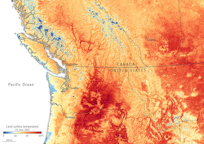 Image:
The heatwave now hitting parts of western Canada and the US has been particularly devastating. This Copernicus Sentinel-3 image shows land surface temperature.
Image:
The heatwave now hitting parts of western Canada and the US has been particularly devastating. This Copernicus Sentinel-3 image shows land surface temperature.