


![]()

zprávy
zdroje zpráv:SAM Announces Acquisition of Marbach
29.6.2021 23:57 GISCafe.com Webcasts-Webinars SAM Companies, the nation's leading provider of geospatial and construction services, is pleased to announce that on June 25, 2021, it completed the …Cepton Integrates Lidars into b-plus’ AVETO Tool Box
29.6.2021 23:57 GISCafe.com Webcasts-Webinars Partnership enables quick-start solutions for sensor data visualization and validation for development of ADAS and AD functionalitiesSAN JOSE, …
Esri User Conference 2021 již za dva týdny. Zúčastnit se můžete i vy, protože také letos bude akce čistě virtuální
29.6.2021 22:24 GeoBusinessV pondělí 12. července 2021 začne další celosvětové setkání geoinformatiků, používajících software firmy Esri. Na letošní Esri User Conference je naplánován program na čtyři dny, tedy na 12. až 15. července. Na konferenci můžete zjistit, jakým směrem se posunul software Esri za předchozích dvanáct měsíců nebo se podívat na vybrané aplikace. Pro účast na konferenci […]
The post Esri User Conference 2021 již za dva týdny. Zúčastnit se můžete i vy, protože také letos bude akce čistě virtuální appeared first on GeoBusiness.
RoboSense Unveils The Smart “GAZE” Function Of Its RS-LiDAR-M1 Zoom Functionality Introduced in the LiDAR
29.6.2021 17:49 GISCafe.com Webcasts-Webinars SHENZHEN, China — (BUSINESS WIRE) — June 29, 2021 —RoboSense (https://robosense.ai/), a smart automotive LiDAR system provider, …
BAE Systems to Deliver M-Code Military GPS User Equipment to Germany
29.6.2021 17:49 GISCafe.com Webcasts-Webinars CEDAR RAPIDS, Iowa — (BUSINESS WIRE) — June 29, 2021 —BAE Systems, Inc. received the first contract from the Space and Missile …
American Robotics Selected to Participate on the FAA’s New Rulemaking Committee to Advance Beyond-Visual-Line-of-Sight (BVLOS) Drone Operations
29.6.2021 17:49 GISCafe.com Webcasts-Webinars American Robotics leads the drone industry as it works with regulators to advance BVLOS flight for commercial dronesMARLBOROUGH, Mass. — …
Flexibility, Scalability And Rich Data: Sense Photonics Launches Platform For Mass Production Lidar, Announces Development Deal With Major OEM
29.6.2021 17:49 GISCafe.com Webcasts-Webinars SAN FRANCISCO, June 29, 2021 — (PRNewswire) — Sense Photonics, the leading global flash Lidar solutions provider, unveiled the world's …S&P CoreLogic Case-Shiller Index Shows Annual Home Price Gains Surged To 14.6% In April
29.6.2021 17:49 GISCafe.com Webcasts-Webinars NEW YORK, June 29, 2021 — (PRNewswire) — S&P Dow Jones Indices (S&P DJI) today released the latest results for the S&P …Maxtena Inc. has added the M9HCT-A-SMA Multi-band GNSS antenna to its helical antenna family
29.6.2021 17:49 GISCafe.com Webcasts-Webinars Maxtena Introducing an advanced Multi-Frequency GNSS Antenna shaped for High Precision applications Featuring L-band corrections.ROCKVILLE, Md., …
Australian Startup Arlula drives Down the Cost of Satellite Images by 25X
29.6.2021 16:37 GISCafe.com Webcasts-Webinars Satellite imagery is a powerful tool that can provide insights over any area of the Earth. For most people, the problem is that it has been …CoreLogic and Xceedance announce extended catastrophe modelling collaboration
29.6.2021 16:37 GISCafe.com Webcasts-Webinars CoreLogic’s complete suite of 180+ catastrophe models to be accessible via on-demand cat modelling services, in partnership with XceedanceIRVINE, …
Maptelligent, Inc., Rebranding Efforts With the Launch of a New Website
29.6.2021 16:37 GISCafe.com Webcasts-Webinars LAS VEGAS, NV, June 29, 2021 (GLOBE NEWSWIRE) -- via NewMediaWire -- Maptelligent, Inc. (OTC PK: MAPT) www.maptelligent.com: Maptelligent, Inc., …Anguilla Launches New Land Information System from Trimble
29.6.2021 16:37 GISCafe.com Webcasts-Webinars SUNNYVALE, Calif., June 29, 2021 — (PRNewswire) — Trimble (NASDAQ: TRMB) announced today that the Anguilla Department of Lands and …GRASS™ Opportunity Zone Fund Acquires Tiger Field in Nevada, Expands Investment in Aviation
29.6.2021 16:37 GISCafe.com Webcasts-Webinars New Airfield could become Nevada Drone Center & Hub with Latest Aviation and Hangar TechnologyCARSON CITY, Nev. — (BUSINESS WIRE) — …
ProStar Announces That It Has Entered Into A Commercial Partnership Agreement With Condux International
29.6.2021 16:37 GISCafe.com Webcasts-Webinars GRAND JUNCTION, Colo., June 29, 2021 — (PRNewswire) — ProStar Holdings Inc ("ProStar" or the "Company") (TSXV: MAPS) (FSE: 5D00), …OneWeb Fully-Funded with New $500m Investment. Secures $2.4bn in Total Funding
29.6.2021 16:37 GISCafe.com Webcasts-Webinars -- Bharti Global (Bharti) exercises Call Option under existing shareholders' agreement to invest an additional $500mLONDON, June 29, 2021 — …
UAV Solutions, Inc. Delivers AsUAS Ghost 60 Platforms to Special Operations Forces
29.6.2021 16:37 GISCafe.com Webcasts-Webinars JESSUP, Md., June 29, 2021 — (PRNewswire) — UAV Solutions, Inc. (UAVS) announced today the company delivered and trained Special …LDROBOT Announces Launch of LD-AIR LiDAR -- Ultra-Small & High-Precision TOF Sensor for All Robotic Applications
29.6.2021 16:37 GISCafe.com Webcasts-Webinars SHENZHEN, China, June 29, 2021 — (PRNewswire) — LDROBOT a high-tech enterprise focusing on the research and development of …Intermap Private Placement Update
29.6.2021 16:37 GISCafe.com Webcasts-Webinars DENVER, Colo., June 29, 2021 — (PRNewswire) — Intermap Technologies (TSX: IMP) (OTCQX: ITMSF) ("Intermap" or the "Company"), a global …Přihlaste se na Uživatelskou konferenci Esri – začíná již za dva týdny
29.6.2021 14:09 ARCDATAUž za dva týdny, v pondělí 12. července, začíná největší setkání geoinformatiků – Uživatelská konference Esri. Během čtyř konferenčních dnů zjistíte, kam se za poslední rok posunuly GIS technologie, nebo si třeba osvojíte efektivnější postupy v aplikacích, se kterými pracujete. Přihlaste se na Uživatelskou konferenci a nechte se inspirovat prací uživatelů z celého světa.
Konference se letos koná virtuální formou a pro vaši účast je nutná registrace na webových stránkách konference pod svým uživatelským účtem Esri.
V následujícím videu se podívejte, co všechno si odborníci z Esri letos přichystali.
EUSPA Highlights EGNOS benefits for Maritime at TRANSAV 2021
29.6.2021 12:00 European GNSS Agency
The 14th International Conference on Marine Navigation and Safety of Sea Transportation took place from 16-18th June 2021.
The 14th edition of the International Conference on Marine Navigation and Safety of Sea Transportation (TRANSAV) took place online from 16-18 June 2021, bringing together scientists and professionals who shared their expertise and research results on all aspects of navigation at sea.
EUSPA Market Development Technology Officer, Prof. Manuel Lopez, co-chaired the round table on GNSS, together with Prof. Cezary Specht, Head of the department of Geodesy and Oceanography of the Maritime University of Gdynia.
Maritime transportation is the backbone of the worldwide economic growth, representing 80% of the global merchant traffic, and a major domain of human and nature activity. Increased marine traffic and the need of accurate manoeuvring in ports are some challenges pilots are faced with.
The maritime community is becoming more and more interested in using SBAS for ocean, coastal waters and harbour entrances/approaches especially where there is no DGNSS infrastructure or in poorly covered environments. EGNOS is already used to effectively complement DGNSS for the provision of enhanced accuracy (close to 1m) and integrity information.
Read this: EGNOS Safety of Life: Serving aviation for 10 years
SBAS systems like EGNOS are set to become a complementary augmentation technology for maritime users. The study of V. Anton et al. on the evolution of SBAS/EGNOS enabled devices in maritime, presented at TRANSNAV shows that currently around 90% of receivers in the market implement SBAS. However, these implementations are not certified following a maritime test standard. The International Electrotechnical Commission (IEC) recently approved a new work item for the preparation of this standard in the next two years. The name of the standard is: IEC 61108-7 ED1 Maritime navigation and radiocommunication equipment and systems - Global navigation satellite systems (GNSS) - Part 7: Satellite Based Augmentation Systems - Receiver Equipment - Performance requirements and method of testing.
During the session moderated by Lopez, participants also had to opportunity to get a taste of how EGNOS performs in high latitudes and more specifically along the Finnish coasts. The study of R. Gonzalez et al. highlights EGNOS suitability in the border of its coverage area, showing an average accuracy of 0.815m in the Gulf of Finland.
The paper Low Bandwith Network-RTK correction dissemination for High Accuracy Maritime Navigation by S. Alissa et al., funded by EUSPA under H2020 project PREParE SHIPS (PREdicted Positioning based on EGNSS for Ships), was nominated as one of the best four papers of the conference. The study described a real-time kinematics network (NRTK) disseminating corrections for GNSS, including Galileo, by means of the modern maritime communication system VDES (VHF Data Exchange System).
Media note: This feature can be republished without charge provided the European Union Agency for the Space Programme (EUSPA) is acknowledged as the source at the top or the bottom of the story. You must request permission before you use any of the photographs on the site. If you republish, we would be grateful if you could link back to the EUSPA website (http://www.euspa.europa.eu).
EUSPA Highlights EGNOS benefits for Maritime at TRANSNAV 2021
29.6.2021 12:00 European GNSS AgencyThe 14th International Conference on Marine Navigation and Safety of Sea Transportation took place from 16-18th June 2021.
The 14th edition of the International Conference on Marine Navigation and Safety of Sea Transportation (TRANSNAV) took place online from 16-18 June 2021, bringing together scientists and professionals who shared their expertise and research results on all aspects of navigation at sea.
EUSPA Market Development Technology Officer, Prof. Manuel Lopez, co-chaired the round table on GNSS, together with Prof. Cezary Specht, Head of the department of Geodesy and Oceanography of the Maritime University of Gdynia.
Maritime transportation is the backbone of the worldwide economic growth, representing 80% of the global merchant traffic, and a major domain of human and nature activity. Increased marine traffic and the need of accurate manoeuvring in ports are some challenges pilots are faced with.
The maritime community is becoming more and more interested in using SBAS for ocean, coastal waters and harbour entrances/approaches especially where there is no DGNSS infrastructure or in poorly covered environments. EGNOS is already used to effectively complement DGNSS for the provision of enhanced accuracy (close to 1m) and integrity information.
Read this: EGNOS Safety of Life: Serving aviation for 10 years
SBAS systems like EGNOS are set to become a complementary augmentation technology for maritime users. The study of V. Anton et al. on the evolution of SBAS/EGNOS enabled devices in maritime, presented at TRANSNAV shows that currently around 90% of receivers in the market implement SBAS. However, these implementations are not certified following a maritime test standard. The International Electrotechnical Commission (IEC) recently approved a new work item for the preparation of this standard in the next two years. The name of the standard is: IEC 61108-7 ED1 Maritime navigation and radiocommunication equipment and systems - Global navigation satellite systems (GNSS) - Part 7: Satellite Based Augmentation Systems - Receiver Equipment - Performance requirements and method of testing.
During the session moderated by Lopez, participants also had to opportunity to get a taste of how EGNOS performs in high latitudes and more specifically along the Finnish coasts. The study of R. Gonzalez et al. highlights EGNOS suitability in the border of its coverage area, showing an average accuracy of 0.815m in the Gulf of Finland.
The paper Low Bandwith Network-RTK correction dissemination for High Accuracy Maritime Navigation by S. Alissa et al., funded by EUSPA under H2020 project PREParE SHIPS (PREdicted Positioning based on EGNSS for Ships), was nominated as one of the best four papers of the conference. The study described a real-time kinematics network (NRTK) disseminating corrections for GNSS, including Galileo, by means of the modern maritime communication system VDES (VHF Data Exchange System).
Media note: This feature can be republished without charge provided the European Union Agency for the Space Programme (EUSPA) is acknowledged as the source at the top or the bottom of the story. You must request permission before you use any of the photographs on the site. If you republish, we would be grateful if you could link back to the EUSPA website (http://www.euspa.europa.eu).
Vrchní referent/rada v oddělení aktualizace GI KN na Katastrálním pracovišti Brno - město
29.6.2021 11:42 ČÚZK - volná místa Katastrální úřad pro Jihomoravský kraj Katastrální pracoviště Brno-město vypisuje výběrové řízení na místo Vrchní referent/rada v oddělení aktualizace GI KN na Katastrálním pracovišti Brno - městoVrchní referent/rada v oddělení aktualizace GI KN na Katastrálním pracovišti Brno - město
29.6.2021 11:42 ČÚZK /Urady/Katastralni-urady/Katastralni-urady/Katastralni-urad-pro-Jihomoravsky-kraj/Volna-mista/DMS/Vrchni-referent-rada-v-oddeleni-aktualizace-GI-KNVrchní referent/rada v oddělení aktualizace GI KN na Katastrálním pracovišti Brno - město
29.6.2021 11:42 ČÚZK - předpisy a opatření Katastrální úřad pro Jihomoravský kraj Katastrální pracoviště Brno-městovypisuje výběrové řízení na místo
Vrchní referent/rada v oddělení aktualizace GI KN na Katastrálním pracovišti Brno - město
Revize KN
29.6.2021 11:25 ČÚZK - předpisy a opatření Katastrální úřad pro Ústecký kraj - Katastrální pracoviště Teplice zveřejnil novou aktualitu: Vážení klienti, oznamujeme Vám, že od 1.9.2021 - do 30.11.2022 bude probíhat v katastrálním území Jenišův Újezd obce Bílina revize katastru nemovitostí. Účelem provádění revize je soulad údajů katastru nemovitostí se skutečným stavem v terénu, kdy jsou zjišťovány změny a ověřován dosavadní stav předmětu evidence katastru nemovitostí.Revize KN
29.6.2021 11:24 ČÚZK - předpisy a opatření Katastrální úřad pro Ústecký kraj - Katastrální pracoviště Teplice zveřejnil novou aktualitu: Vážení klienti, oznamujeme Vám, že od 1.9.2021 - do 30.11.2022 bude probíhat v katastrálním území Břešťany obce Bílina revize katastru nemovitostí. Účelem provádění revize je soulad údajů katastru nemovitostí se skutečným stavem v terénu, kdy jsou zjišťovány změny a ověřován dosavadní stav předmětu evidence katastru nemovitostí.Revize KN
29.6.2021 11:23 ČÚZK - předpisy a opatření Katastrální úřad pro Ústecký kraj - Katastrální pracoviště Teplice zveřejnil novou aktualitu: Vážení klienti, oznamujeme Vám, že od 1.9.2021 - do 30.11.2022 bude probíhat v katastrálním území Břežánky obce Bílina revize katastru nemovitostí. Účelem provádění revize je soulad údajů katastru nemovitostí se skutečným stavem v terénu, kdy jsou zjišťovány změny a ověřován dosavadní stav předmětu evidence katastru nemovitostí.Descartes Labs Achieves #41 in TOP500 With Cloud-Based Supercomputing Demonstration Powered by AWS, Signaling New Era for Geospatial Data Analysis at Scale
29.6.2021 0:57 GISCafe.com Webcasts-Webinars Descartes Labs uses Amazon Web Services, Inc. (AWS) to run a 9.95 petaflops High-Performance LINPACK (HPL) benchmark, placing it #41 in the June 2021 …Airbus to provide satellite-based maritime surveillance services for the UK Royal Navy
28.6.2021 20:41 GISCafe.com Webcasts-Webinars Guilford, 28 June 2021 – The UK Royal Navy has awarded a 12 month contract extension to Airbus covering the continued provision of …Esri Enters Memorandum of Understanding with Ibn Zohr University
28.6.2021 20:39 GISCafe.com Webcasts-Webinars Strategic Collaboration Will Further Training and Use of GIS among Students, Professors, ResearchersREDLANDS, Calif. — (BUSINESS WIRE) — …
Datový standard staveb DSS má vydánu první část, použitelnou v dokumentaci pro stavební povolení
28.6.2021 20:05 BIM NewsKateřina Schön, vedoucí výkonného projektového týmu agentury ČAS pro datový standard staveb (DSS) oznámila, že byla vydána první část DSS. Využití má v dokumentaci pro stavební povolení (DSP). Datový standard staveb (DSS) je soubor požadavků na negrafické informace (vlastnosti) o stavbě spolu s požadavky, jak bude stavba, nebo její dílčí části, graficky modelována. První část […]
The post Datový standard staveb DSS má vydánu první část, použitelnou v dokumentaci pro stavební povolení appeared first on BIM News.
KORE Enabled IoT Technology Powers Drones to Deliver Critical Medical Assets
28.6.2021 17:15 GISCafe.com Webcasts-Webinars Swoop Aero leverages KORE satellite connectivity and eSIM technology to deliver vaccines and medical supplies in remote and rural parts of the …M2Catalyst and HERE partner to improve the mobile network experience
28.6.2021 17:15 GISCafe.com Webcasts-Webinars Time and cost saving tools for 5G buildout and managing 3/4/5G networks MWC 2021 – HERE Technologies, the leading location data and technology …odborný/vrchní referent – poskytování informací KN a PK, poskytování podkladů, nahlížení do KN v odd
28.6.2021 16:57 ČÚZK - volná místa Katastrální úřad pro Jihočeský kraj Katastrální pracoviště Jindřichův Hradec vypisuje výběrové řízení na místo odborný/vrchní referent – poskytování informací KN a PK, poskytování podkladů, nahlížení do KN v oddodborný/vrchní referent – poskytování informací KN a PK, poskytování podkladů, nahlížení do KN v odd
28.6.2021 16:57 ČÚZK - předpisy a opatření Katastrální úřad pro Jihočeský kraj Katastrální pracoviště Jindřichův Hradecvypisuje výběrové řízení na místo
odborný/vrchní referent – poskytování informací KN a PK, poskytování podkladů, nahlížení do KN v oddělení dokumentace KN Katastrálního pracoviště Jindřichův Hradec (ID SM 30000213/30003837)
odborný/vrchní referent – poskytování informací KN a PK, poskytování podkladů, nahlížení do KN v odd
28.6.2021 16:57 ČÚZK /Urady/Katastralni-urady/Katastralni-urady/Katastralni-urad-pro-Jihocesky-kraj/Uredni-deska/Oznameni-a-jina-uredni-sdeleni/Volna-mista/DMS/odborny-vrchni-referent-–-poskytovani-informaci-KNvrchní referent/rada – obnova katastrálního operátu v oddělení aktualizace KN Katastrálního pracoviš
28.6.2021 16:35 ČÚZK - volná místa Katastrální úřad pro Jihočeský kraj Katastrální pracoviště Jindřichův Hradec vypisuje výběrové řízení na místo vrchní referent/rada – obnova katastrálního operátu v oddělení aktualizace KN Katastrálního pracovišvrchní referent/rada – obnova katastrálního operátu v oddělení aktualizace KN Katastrálního pracoviš
28.6.2021 16:35 ČÚZK - předpisy a opatření Katastrální úřad pro Jihočeský kraj Katastrální pracoviště Jindřichův Hradecvypisuje výběrové řízení na místo
vrchní referent/rada – obnova katastrálního operátu v oddělení aktualizace KN Katastrálního pracoviště Jindřichův Hradec (ID SM 30000201/30003825)
vrchní referent/rada – obnova katastrálního operátu v oddělení aktualizace KN Katastrálního pracoviš
28.6.2021 16:35 ČÚZK /Urady/Katastralni-urady/Katastralni-urady/Katastralni-urad-pro-Jihocesky-kraj/Uredni-deska/Oznameni-a-jina-uredni-sdeleni/Volna-mista/DMS/vrchni-referent-rada-–-obnova-katastralniho-operatMaking Europe fit for the Digital Age with the European Connectivity Initiative
28.6.2021 16:34 European GNSS Agency
Complementing Copernicus, Galileo, EGNOS, and the forthcoming GOVSATCOM, this new EU flagship programme, will benefit a broad range of sectors, including road and maritime transport, air traffic and control, autonomous vehicle development as well Internet of Things (IoT). It will also open up more opportunities for synergies between the already existing components of the EU Space Programme that can benefit maritime surveillance or even space situational awareness.
“I want to position Europe as THE hub of space entrepreneurship in the world”. With this remark Commissioner for Internal Market, Thierry Breton, kicked off the Q&A session with SMEs and start-ups during the Secure Connectivity Initiative online event organized by DG-DEFIS on 14 June 2021.
The landscape of the space industry is being reshaped as we are entering a new era in the field of satellite communications. The use of new frequency bands, optical communications and quantum technology allows for the development of new innovative products and software. Europe is gifted with a satcom industry that has the capacity to make the necessary technological leap while at the same time New-Space entrepreneurs are able to think outside the box and create new services that can benefit users.
The EU is ready to harness this momentum of digitisation and make Europe fit for the digital age under its new European Connectivity Initiative.
The Secure Connectivity Initiative, announced in early 2020 by Breton during his keynote at the 13th European Space Conference will be a multi-orbital project, combining the benefits offered by LEO, GEO and MEO constellations. It is set to provide secure communication services to the EU and its Member States as well as broadband connectivity for European citizens, private companies and governmental authorities. This new initiative aims to put an end to dead zones, giving high broadband speed to everyone in Europe and some areas of Africa through a resilient & ultra-secure space and ground based system.
The EU Agency for the Space Programme, is already actively involved in building secure satellite communications infrastructures for Europe through the coordination of the first phase of GOVSATCOM on which the new secure connectivity initiative will be based. Complementing Copernicus, Galileo, EGNOS and the forthcoming GOVSATCOM, this new EU flagship programme, will benefit a broad range of sectors, including road and maritime transport, air traffic and control as well Internet of Things (IoT). Such a project will also open up more opportunities for synergies between the already existing components of the EU Space Programme. By combining GNSS data and satcom networks we can significantly improve space situational awareness. Likewise, the synergies between EO, SatNav and SatCom can be useful for fisheries control and maritime surveillance.
With the addition of the Secure Connectivity Initiative, the EU is ramping up the digitisation of its society and economy while looking to make space data more accessible and scalable to all interested entities. This will ensure reliance on Europe’s own space resources and infrastructure and therefore strengthen its digital sovereignty.
EUSPA will be supporting the EU’s digital transition by giving incentives to new entrants in order to scale-up the creation of innovative start-ups. This will be done through instruments such as the CASSINI initiative, Horizon Europe calls and other innovation competitions.
Media note: This feature can be republished without charge provided the European Union Agency for the Space Programme (EUSPA) is acknowledged as the source at the top or the bottom of the story. You must request permission before you use any of the photographs on the site. If you republish, we would be grateful if you could link back to the EUSPA website (http://www.euspa.europa.eu).
Making Europe fit for the Digital Age with the European Connectivity Initiative
28.6.2021 16:34 European GNSS AgencyComplementing Copernicus, Galileo, EGNOS, and the forthcoming GOVSATCOM, this new EU flagship programme, will benefit a broad range of sectors, including road and maritime transport, air traffic and control, autonomous vehicle development as well Internet of Things (IoT). It will also open up more opportunities for synergies between the already existing components of the EU Space Programme that can benefit maritime surveillance or even space situational awareness.
“I want to position Europe as THE hub of space entrepreneurship in the world”. With this remark Commissioner for Internal Market, Thierry Breton, kicked off the Q&A session with SMEs and start-ups during the Secure Connectivity Initiative online event organized by DG-DEFIS on 14 June 2021.
The landscape of the space industry is being reshaped as we are entering a new era in the field of satellite communications. The use of new frequency bands, optical communications and quantum technology allows for the development of new innovative products and software. Europe is gifted with a satcom industry that has the capacity to make the necessary technological leap while at the same time New-Space entrepreneurs are able to think outside the box and create new services that can benefit users.
The EU is ready to harness this momentum of digitisation and make Europe fit for the digital age under its new European Connectivity Initiative.
The Secure Connectivity Initiative, announced in early 2020 by Breton during his keynote at the 13th European Space Conference will be a multi-orbital project, combining the benefits offered by LEO, GEO and MEO constellations. It is set to provide secure communication services to the EU and its Member States as well as broadband connectivity for European citizens, private companies and governmental authorities. This new initiative aims to put an end to dead zones, giving high broadband speed to everyone in Europe and some areas of Africa through a resilient & ultra-secure space and ground based system.
The EU Agency for the Space Programme, is already actively involved in building secure satellite communications infrastructures for Europe through the coordination of the first phase of GOVSATCOM on which the new secure connectivity initiative will be based. Complementing Copernicus, Galileo, EGNOS and the forthcoming GOVSATCOM, this new EU flagship programme, will benefit a broad range of sectors, including road and maritime transport, air traffic and control as well Internet of Things (IoT). Such a project will also open up more opportunities for synergies between the already existing components of the EU Space Programme. By combining GNSS data and satcom networks we can significantly improve space situational awareness. Likewise, the synergies between EO, SatNav and SatCom can be useful for fisheries control and maritime surveillance.
With the addition of the Secure Connectivity Initiative, the EU is ramping up the digitisation of its society and economy while looking to make space data more accessible and scalable to all interested entities. This will ensure reliance on Europe’s own space resources and infrastructure and therefore strengthen its digital sovereignty.
EUSPA will be supporting the EU’s digital transition by giving incentives to new entrants in order to scale-up the creation of innovative start-ups. This will be done through instruments such as the CASSINI initiative, Horizon Europe calls and other innovation competitions.
Media note: This feature can be republished without charge provided the European Union Agency for the Space Programme (EUSPA) is acknowledged as the source at the top or the bottom of the story. You must request permission before you use any of the photographs on the site. If you republish, we would be grateful if you could link back to the EUSPA website (http://www.euspa.europa.eu).
rada/odborný rada – obnova katastrálního operátu v oddělení obnovy a revize KN Katastrálního pracovi
28.6.2021 16:15 ČÚZK /Urady/Katastralni-urady/Katastralni-urady/Katastralni-urad-pro-Jihocesky-kraj/Uredni-deska/Oznameni-a-jina-uredni-sdeleni/Volna-mista/DMS/rada-odborny-rada-–-obnova-katastralniho-operatu-vrada/odborný rada – obnova katastrálního operátu v oddělení obnovy a revize KN Katastrálního pracovi
28.6.2021 16:15 ČÚZK - volná místa Katastrální úřad pro Jihočeský kraj Katastrální pracoviště České Budějovice vypisuje výběrové řízení na místo rada/odborný rada – obnova katastrálního operátu v oddělení obnovy a revize KN Katastrálního pracovirada/odborný rada – obnova katastrálního operátu v oddělení obnovy a revize KN Katastrálního pracovi
28.6.2021 16:15 ČÚZK - předpisy a opatření Katastrální úřad pro Jihočeský kraj Katastrální pracoviště České Budějovicevypisuje výběrové řízení na místo
rada/odborný rada – obnova katastrálního operátu v oddělení obnovy a revize KN Katastrálního pracoviště České Budějovice
Přerušení provozu Webových služeb pro geodety od pátku 2.7.2021 14:30 do cca úterý 6.7.2021
28.6.2021 15:57 ČÚZK /Aplikace-DP-do-KN/Aplikace-DP-do-KN/Archiv-DP/326094Přerušení provozu Webových služeb pro geodety od pátku 2.7.2021 14:30 do cca úterý 6.7.2021
28.6.2021 15:57 ČÚZK - předpisy a opatření Vážení uživatelé,oznamujeme, že od pátku 2.7.2021 od 14:30 bude z provozních důvodů zcela přerušen provoz Webových služeb pro geodety. Obnovení provozu předpokládáme nejpozději v úterý 6.7.2021 – s ohledem na povahu prováděných činností nelze bohužel nyní stanovit přesnější termín zprovoznění služby. U této odstávky nedochází ke změnám webových služeb.
Za komplikace tímto způsobené se omlouváme a děkujeme za pochopení.
Přerušení provozu Webových služeb pro geodety od pátku 2.7.2021 14:30 do cca úterý 6.7.2021
28.6.2021 15:57 Dálkový přístup k údajům KN ČR Vážení uživatelé,oznamujeme, že od pátku 2.7.2021 od 14:30 bude z provozních důvodů zcela přerušen provoz Webových služeb pro geodety. Obnovení provozu předpokládáme nejpozději v úterý 6.7.2021 – s ohledem na povahu prováděných činností nelze bohužel nyní stanovit přesnější termín zprovoznění služby. U této odstávky nedochází ke změnám webových služeb.
Za komplikace tímto způsobené se omlouváme a děkujeme za pochopení.
Bylo publikováno nové sestaven
28.6.2021 14:21 GEUSware Bylo publikováno nové sestavení GEUS 25.0.4.322. Toto sestavení mimo jiné reaguje na změny aplikace ČÚZK z 12.6.2021 (captcha kódy). 20210628 - odstávka ISÚI a VDP
28.6.2021 13:55 ČÚZK /Uvod/Produkty-a-sluzby/RUIAN/RUIAN-novinky/2021/20210628-odstavka-ISUI-a-VDPOdborný / vrchní referent v oddělení obnovy katastrálního operátu II. v technickém odboru na Katastr
28.6.2021 12:40 ČÚZK /Urady/Katastralni-urady/Katastralni-urady/Katastralni-urad-pro-Ustecky-kraj/Volna-mista/DMS/Odborny-vrchni-referent-v-oddeleni-obnovy-katastOdborný / vrchní referent v oddělení obnovy katastrálního operátu II. v technickém odboru na Katastr
28.6.2021 12:40 ČÚZK - předpisy a opatření Katastrální úřad pro Ústecký kraj technický odborvypisuje výběrové řízení na místo
Odborný / vrchní referent v oddělení obnovy katastrálního operátu II. v technickém odboru na Katastrálním úřadu pro Ústecký kraj
Odborný / vrchní referent v oddělení obnovy katastrálního operátu II. v technickém odboru na Katastr
28.6.2021 12:40 ČÚZK - volná místa Katastrální úřad pro Ústecký kraj technický odbor vypisuje výběrové řízení na místo Odborný / vrchní referent v oddělení obnovy katastrálního operátu II. v technickém odboru na KatastrNominace na ocenění Mapa roku 2020 (TZ)
28.6.2021 8:53 GISportal.cz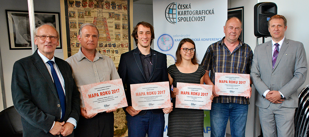
Nominace na ocenění Mapa roku 2020 (TZ)
28.6.2021 8:53 GISportal.czČeská kartografická společnost v roce 2021 uspořádala v pořadí již 23. ročník soutěže Mapa roku. Odborná komise pro soutěž Mapa roku zhodnotila na svém červnovém zasedání přihlášená kartografická díla vydaná na území České republiky v roce 2020 a vyhlásila nominace na ocenění. Uzávěrka pro přihlášení kartografických děl a výsledků studentských prací byla 31. března 2021 a následující období patřilo podrobnému hodnocení produktů jednotlivými členy […]
The post Nominace na ocenění Mapa roku 2020 (TZ) appeared first on GISportal.cz.
Rada/odborný rada – obnova katastrálního operátu
28.6.2021 8:39 ČÚZK - předpisy a opatření Katastrální úřad pro Plzeňský kraj Katastrální pracoviště Klatovyvypisuje výběrové řízení na místo
Rada/odborný rada – obnova katastrálního operátu
Rada/odborný rada – obnova katastrálního operátu
28.6.2021 8:39 ČÚZK /Urady/Katastralni-urady/Katastralni-urady/Katastralni-urad-pro-Plzensky-kraj/Uredni-deska/Oznameni-a-jina-uredni-sdeleni/Volna-mista/DMS/Rada-odborny-rada-–-obnova-katastralniho-operatu-(Rada/odborný rada – obnova katastrálního operátu
28.6.2021 8:39 ČÚZK - volná místa Katastrální úřad pro Plzeňský kraj Katastrální pracoviště Klatovy vypisuje výběrové řízení na místo Rada/odborný rada – obnova katastrálního operátuRada/odborný rada – obnova katastrálního operátu
28.6.2021 8:37 ČÚZK /Urady/Katastralni-urady/Katastralni-urady/Katastralni-urad-pro-Plzensky-kraj/Uredni-deska/Oznameni-a-jina-uredni-sdeleni/Volna-mista/DMS/Rada-odborny-rada-–-obnova-katastralniho-operatuRada/odborný rada – obnova katastrálního operátu
28.6.2021 8:37 ČÚZK - volná místa Katastrální úřad pro Plzeňský kraj Katastrální pracoviště Domažlice vypisuje výběrové řízení na místo Rada/odborný rada – obnova katastrálního operátuRada/odborný rada – obnova katastrálního operátu
28.6.2021 8:37 ČÚZK - předpisy a opatření Katastrální úřad pro Plzeňský kraj Katastrální pracoviště Domažlicevypisuje výběrové řízení na místo
Rada/odborný rada – obnova katastrálního operátu
Harmonogram státních závěrečných zkoušek - magisterské studium (jaro 2021)
28.6.2021 0:00 Geografický ústav MUhttps://is.muni.cz/auth/www/herber/Harmonogram_SZZ_mgr_jaro_2021_rozpis_geografie.pdf
Státní pozemkový úřad eviduje 314 vodních nádrží
28.6.2021 0:00 Státní pozemkový úřad Praha, 28. června 2021 – Státní pozemkový úřad (SPÚ) ku příležitosti Světového dne rybářství, který připadá na 27. června, zrevidoval data týkající se počtu rybníků v příslušnosti hospodařit SPÚ a zároveň v posledních 7 letech zrealizoval 292 prvků vodohospodářských opatřeních.American drone maker Skyfish secures over $20 million in Series Seed funding; appoints Cell Tower Industry Veteran Steven Bernstein to its Board of Directors
26.6.2021 3:17 GISCafe.com Webcasts-Webinars MISSOULA, Mont., June 25, 2021 (GLOBE NEWSWIRE) -- American autonomous drone maker Skyfish has secured over $20 million in a venture-backed Series …Kartografové píší o kartografii. Podívejte se, co je v novém speciálu International Journal of Cartography
25.6.2021 19:37 GeoBusinessDruhé letošní vydání magazínu International Journal of Cartography je k dispozici online. Speciál nese podtitul „Cartographers write about Cartography“. Obsah vydání International Journal of Cartography 2/2021 Editorial: Cartographers Write About Cartography by William Cartwright, Anne Ruas and Kenneth Field The Heart of the Grand Canyon by Tom Patterson OCTOPUS MAPPING one of the MADMAPS: NATO […]
The post Kartografové píší o kartografii. Podívejte se, co je v novém speciálu International Journal of Cartography appeared first on GeoBusiness.
Planetek will provide Eni with satellite data and services for the next three years
25.6.2021 18:18 GISCafe.com Webcasts-Webinars The Italian energy company will use satellite data to gather geoinformation for a wide range of activities, spanning from engineering, to …Horizon Europe Info Days: Seizing EU Space to build #NextGenerationEU
25.6.2021 12:37 European GNSS Agency
With an allocated budget of EUR 95.5 billion for the period 2021-2027, Horizon Europe is the new EU research and innovation funding programme, poised to develop sustainable solutions to tackle climate change, boost competitiveness and create jobs. Targeting public authorities, universities, research institutes, companies and other organizations, the Programme also facilitates collaboration, and strengthens the impact of research and innovation in developing, supporting, and implementing EU policies.
Throughout the years, the EU research and innovation (R&I) funding programmes (FP6, FP7, H2020 to name but a few) have been fueling Europe’s future and growth. As Europe slowly emerges from the pandemic, R&I will become even more crucial to develop much needed solutions to tackle global and societal challenges, and build a more sustainable, secure and resilient European Union.
While the European Commission fully-fledged #NextGenerationEU recovery plan aims to support and stimulate national economies, Horizon Europe targets solutions to turn our continent greener, more digital and more resilient leveraging on the European Union excellence in research and academia, and its innovation and creativity capital among industry, SMEs, and entrepreneurs.
With an allocated budget of EUR 95.5 billion for the period 2021-2027, the enhanced successor of Horizon 2020, is the EU’s vehicle to tackle climate change, boost competitiveness and create jobs. Targeting public authorities, universities, research institutes, companies and other organizations, the new Programme also facilitates the collaboration and strengthens the impact of research and innovation in developing, supporting and implementing EU policies.
EU Space data based on Galileo, Copernicus and EGNOS is enabling the development of next-generation, innovative applications or technologies especially in the downstream sectors such as mobility, smart farming, shared economy, Consumer solutions, surveying, and leisure, among others. Horizon Europe will feature a set of calls to support R&I within the context of the new EU Space Programme.
Add Info Days to your calendar!
The European Commission is organizing the Horizon Europe Info Days 2021 with the objective to inform prospective applicants and other stakeholders, about the main funding instruments and processes, and the novelties of Horizon Europe. The Info-days will address 9 themes, each featuring a programme with discussions and hands-on sessions, and dedicated to individual clusters or parts of the new Programme.
Cluster 4 Digital, Industry and Space focuses on the following six destinations matching the Strategic Plan:
- Climate neutral, circular and digitised production;
- Increased autonomy in key strategic value chains for resilient industry;
- World leading data and computing technologies;
- Digital and emerging technologies for competitiveness and fit for the Green Deal;
- Open strategic autonomy in developing, deploying and using global space-based infrastructures, services, applications and data;
- A human-centred and ethical development of digital and industrial technologies
The destination five will provide first-hand information on EU Space related calls.
This Info-day will take place on 29 June 2021 from 09:00 until 17:00 CET and no prior registration is required. Participants will have the opportunity to first attend a “Welcome and general presentation of the 'Digital, Industry and Space' 2021 Work Programme” while under Destination 5 they will be informed about “Open strategic autonomy in developing, deploying and using global space-based infrastructures, services, applications and data”.
More information can be found here.
There is more
To complement Horizon Europe Info Days 2021, the National Contact Points (NCPs), under Bridge2HE, ID2020 and Cosmos2020, are promoting three different Brokerage events to support the forming of consortia. Interested? Sign up at the links below:
Digital: 24-25th June 2021 https://digital2021.ideal-ist.eu
Industry: 1st July 2021 https://industry2021.b2match.io
Space: 28th June 2021 https://cosmos2020plus-heu-cluster4-space-brokerage.b2match.io
Stipendia na letošní International Cartographic Conference (ICC) ve Florencii
25.6.2021 10:36 GeoBusinessTřicátá mezinárodní kartografická konference se letos koná v italském městě Florencie. Uzávěrka příjmu žádostí na stipendia Mezinárodní kartografické asociace ICA na podporu mladších profesionálů, vědců a vědkyň mají posunutý termín pro přijetí příspěvků a abstraktů do 13. července 2021. Background The International Cartographic Association (ICA) will consider applications for grants to support individuals in advancing […]
The post Stipendia na letošní International Cartographic Conference (ICC) ve Florencii appeared first on GeoBusiness.
Lokalizace ArcGIS Pro 2.8
25.6.2021 10:35 ARCDATAČeská lokalizace ArcGIS Pro 2.8 je k dispozici ke stažení na portálu My Esri.
Pokud ArcGIS Pro 2.8 již používáte v angličtině, můžete si na My Esri stáhnout jen lokalizační balíček. (Moje organizace – Stahování – ArcGIS Pro – Zobrazit stahování – sekce jazykových balíčků je na konci seznamu.)
Earth from Space: Lake Mar Chiquita
25.6.2021 10:00 ESA Observing the Earth
The Copernicus Sentinel-1 mission takes us over Lake Mar Chiquita – an endorheic salt lake in the northeast province of Córdoba, Argentina.
23. setkání uživatelů produktů a služeb společnosti T‑MAPY
25.6.2021 9:46 GeoBusinessFirma T-MAPY ve svém zpravodaji oznámila termín své akce. 23. setkání uživatelů produktů a služeb společnosti T‑MAPY se bude konat ve dnech 13. a 14. září 2021. Poslední léta se akce pravidelně koná v kongresovém hotelu Jezerka v Ústupkách u Seče. Program setkání bude upřesněn v průběhu srpna 2021, zatím je znám rámcový program, tematicky […]
The post 23. setkání uživatelů produktů a služeb společnosti T‑MAPY appeared first on GeoBusiness.
Konference GIS Esri v ČR se letos uskuteční, opět to bude virtuální formou
25.6.2021 9:35 GeoBusinessFirma Arcdata Praha, organizátor konference GIS Esri v ČR, oznámila, že „přesto, že se svět pomalu začíná vracet do běžného režimu, nejsme v tuto chvíli schopni zaručit, že bychom se v listopadu mohli sejít tak, jako dříve. A proto jsme se i letos rozhodli konferenci uspořádat virtuální formou.“ Hlavním důvodem je velikost akce. Konferenci pravidelně […]
The post Konference GIS Esri v ČR se letos uskuteční, opět to bude virtuální formou appeared first on GeoBusiness.
GeoFutures Marks One-Year Anniversary of Release of Strategic Roadmap for St. Louis’ Geospatial Sector
25.6.2021 9:00 GISCafe.com Webcasts-Webinars Local geospatial ecosystem has acted quickly on strategic priorities and initiatives designed to make St. Louis the world’s geospatial hub in …Bluesky MetroVista Models Transform Real Estate Marketing with 3D Visualisations
25.6.2021 9:00 GISCafe.com Webcasts-Webinars Leicestershire, UK, 24 June 2021 - Photorealistic 3D models from aerial mapping specialist Bluesky are being used to create real-world interactive …Urban Air Mobility Division of Hyundai Motor Group and ANRA Technologies Launch Partnership to Develop Advanced Air Mobility Air Traffic Operating Environment
25.6.2021 9:00 GISCafe.com Webcasts-Webinars WASHINGTON, June 23, 2021 — (PRNewswire) — The Urban Air Mobility Division of Hyundai Motor Group announced today a new partnership with …Mauritius deploys first satellite thanks to UNOOSA and JAXA KiboCUBE programme
25.6.2021 9:00 GISCafe.com Webcasts-Webinars VIENNA, 22 June (United Nations Information Service) — Today, the team from the Mauritius Research and Innovation Council (MRIC), winners of …Konference GIS Esri v ČR se i letos uskuteční virtuální formou
25.6.2021 8:54 GISportal.cz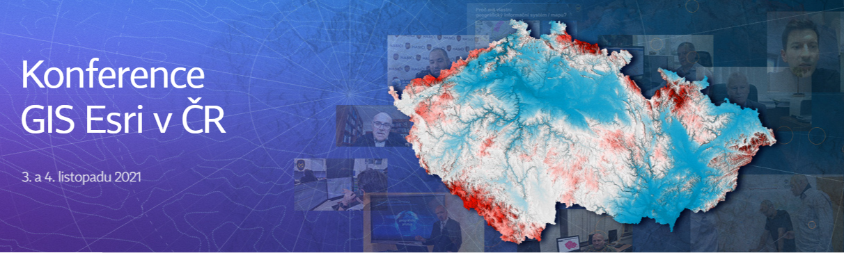
I když je to více než rok, kdy pandemie COVID-19 zásadním způsobem vstoupila do našich životů a svět pomalu začíná vracet do běžného režimu, organizátoři konference GIS Esri v ČR nejsou v tuto chvíli schopni zaručit, že bychom se v listopadu mohli sejít tak, jako dříve. A proto se i letos rozhodli konferenci uspořádat virtuální […]
The post Konference GIS Esri v ČR se i letos uskuteční virtuální formou appeared first on GISportal.cz.
Konference GIS Esri v ČR se i letos uskuteční virtuální formou
25.6.2021 8:54 GISportal.czOtevřené jaro uspořádalo hackathon, který má nyní své vítěze
25.6.2021 8:31 GeoBusinessDvouměsíční INSPIRE hackathon, pořádaný v rámci Otevřeného jara, má své vítěze. The Open Spring INSPIRE Hackathon 2021 focused on developments and innovations in agriculture, the environment, transport, tourism, geospatial applications, remote sensing and GNSS is after two-month hacking over. More than 70 participants have contributed to all 11 very relevant series of challenges and their results […]
The post Otevřené jaro uspořádalo hackathon, který má nyní své vítěze appeared first on GeoBusiness.
Leica představila nové řešení iCON iXE3 3D pro řízení stavebních strojů
25.6.2021 8:26 GeoBusinessLeica Geosystems, součást švédského koncernu Hexagon, představila nové řešení Leica iCON iXE3 3D, zaměřené na řízení stavebních strojů. Konkrétně je toto řešení zaměřeno na kompaktní rypadla a rypadla s otočným výložníkem. Contractors rely on efficient workflows for applications such as trenching for footings, grading ditches or digging out basements. As such, demand for technology enabled […]
The post Leica představila nové řešení iCON iXE3 3D pro řízení stavebních strojů appeared first on GeoBusiness.
Hexagon představil Luciad 2021
25.6.2021 8:14 GeoBusinessFirma Hexagon představila novou verzi svého geoprostorového softwarového balíku Luciad, nově má označení 2021. Hexagon’s Safety, Infrastructure & Geospatial division announced the release of Luciad 2021, a significant update to its platform for building advanced location intelligence and real-time, situational awareness applications. Luciad 2021 delivers enhanced performance, improved development capabilities and more dynamic web applications. With […]
The post Hexagon představil Luciad 2021 appeared first on GeoBusiness.
Co zaznělo na prvním setkání české pobočky buildingSMART, které uspořádala Odborná rada pro BIM
25.6.2021 8:11 BIM NewsOdborná rada pro BIM se na jaře stala členem mezinárodního uskupení buildingSMART a nyní uspořádala představovací setkání.
The post Co zaznělo na prvním setkání české pobočky buildingSMART, které uspořádala Odborná rada pro BIM appeared first on BIM News.
Skyward and Federal Aviation Administration to Test Cellular-Connected Drones
25.6.2021 2:17 GISCafe.com Webcasts-Webinars PORTLAND, Ore., June 24, 2021 (GLOBE NEWSWIRE) -- Skyward, A Verizon company, has signed a Memorandum of Agreement (MOA) with the Federal Aviation …OGC and Topio Networks Announce New Partnership to Share Latest Innovations in the Location and GeoSpatial Ecosystem
25.6.2021 2:17 GISCafe.com Webcasts-Webinars New partnership will provide a newsfeed aimed to help decision-makers, industry analysts, and technology developers keep pace with the accelerating …Státní pozemkový úřad uvolňuje 100 milionů za účelem odstranění následků včerejší bouře s tornádem na jižní Moravě
25.6.2021 0:00 Státní pozemkový úřad Praha, 25. června 2021 – Státní pozemkový úřad (SPÚ) po dohodě s Ministerstvem zemědělství (MZe) uvolní obratem 100 miliónů Kč ze svého letošního rozpočtu. Uvolněné finance budou MZe přesměrovány do programů na pomoc s obnovou infrastruktury v poničených obcích za účelem odstranění následků včerejší přírodní katastrofy především v oblasti Jihomoravského kraje.LeddarTech and Cognata Join Forces to Accelerate the $20B Agriculture Autonomous Vehicle Market
24.6.2021 18:04 GISCafe.com Webcasts-Webinars LeddarTech to Integrate Cognata Solution into LeddarTech's Autonomous Driving Perception Software Platform, Powering Large-Scale AV …Nabídky práce společnosti CEDA Maps a. s.
24.6.2021 17:28 Geografický ústav MUSpolečnost CEDA Maps a. s. hledá kolegy na řadu pozic.
ÚCL spustilo očekávanou registraci do podkategorie A2 provozu
24.6.2021 17:24 UAVA❗A2 registrace spuštěna ❗ Úřad pro civilní letectví dnes zveřejnil dlouho očekávané postupy k způsobilosti pilotů pro provoz v podkategorii provozu A2, včetně možnosti uznání způsobilosti dálkově řídícího pilota, kteří úspěšně absolvovali postup Úřadu pro ověření teoretických znalostí a praktických dovedností pilota a letových vlastností bezpilotního letadla pro odstranění tzv. žákovských omezení před 31. prosincem […]
The post ÚCL spustilo očekávanou registraci do podkategorie A2 provozu appeared first on UAV Aliance pro bezpilotní letecký průmysl.
Official geospatial data proves value during global pandemic
24.6.2021 16:39 GISCafe.com Webcasts-Webinars EuroGeographics Annual Review shows how members provide more than mapsContributing to national Covid-19 responses has significantly raised …
Maxar’s 3D Data Suite and Satellite Imagery to Support National Security Missions for the Australian Department of Defence
24.6.2021 16:37 GISCafe.com Webcasts-Webinars WESTMINSTER, Colo. — (BUSINESS WIRE) — June 24, 2021 —Maxar Technologies (NYSE:MAXR) (TSX:MAXR), a trusted partner and innovator …
Velodyne Lidar Launches India Design Center in Bangalore
24.6.2021 16:37 GISCafe.com Webcasts-Webinars Center Advances Velodyne’s Hyper-Focus on Sensor and Software Innovation to Propel Continued Business GrowthSAN JOSE, Calif. — (BUSINESS …
Proctorio Selected as FAA-Approved Test Administrator of The Recreational UAS Safety Test (TRUST)
24.6.2021 16:37 GISCafe.com Webcasts-Webinars Proctorio has been selected as an FAA-approved Test Administrator (TA) of The Recreational UAS Safety Test (TRUST), along with Embry-Riddle …SpaceJLTZ Selects TerraStream to Manage Hyperspectral Data for Precision Agriculture Application
24.6.2021 16:37 GISCafe.com Webcasts-Webinars The SpaceJLTZ payload will be onboard the D2/Atlacom-1 high-performance nanosatellite, developed by the Hyperactive Consortium, launching on SpaceX's …Kratos Awarded $8.6 Million Task Order to Complete 50shp Class Recuperated Turbine Engine for Future Group 3 UAVs
24.6.2021 16:37 GISCafe.com Webcasts-Webinars SAN DIEGO, June 24, 2021 (GLOBE NEWSWIRE) -- Kratos Defense & Security Solutions, Inc. (Nasdaq: KTOS), a leading National Security Solutions …Esri Releases New 2020 Global Land Cover Map
24.6.2021 16:37 GISCafe.com Webcasts-Webinars Project Joins Startup Impact Observatory and Microsoft to Deliver Map to Worldwide UsersREDLANDS, Calif. — (BUSINESS WIRE) — June 24, …
Major Western Utility Selects NV5 for $9 Million in Surveying, Permitting, and Technical Services
24.6.2021 16:37 GISCafe.com Webcasts-Webinars HOLLYWOOD, Fla., June 24, 2021 (GLOBE NEWSWIRE) -- NV5 Global, Inc. (the “Company” or “NV5”) (Nasdaq: NVEE), a provider of compliance, …ProStar, the World Leader in Developing Precision Mapping Solutions®, Has Been Granted Another Major Canadian Patent
24.6.2021 16:37 GISCafe.com Webcasts-Webinars GRAND JUNCTION, Colo., June 24, 2021 — (PRNewswire) — ProStar Holdings Inc. ("ProStar®" or the "the Company") (TSXV: MAPS) (FSE: 5D00), …
Plánovaná odstávka MK ZBGIS
24.6.2021 15:55
ÚGKK SR
Dňa 29.6.2021 v čase od 16:00 do 22:00 hod. je plánované nasadenie novej verzie aplikácie Mapový klient ZBGIS.
Z dôvodu zmeny údajového modelu dôjde k odstráneniu používateľských nastavení (meranie, kreslenie, identifikácia, vaše miesta, zdieľanie, pripojené súbory/služby,...)!
Za vzniknuté problémy sa ospravedlňujeme.
Tím ZBGIS
Ohrožují nové 5G sítě spolehlivý příjem GPS / GNSS signálů?
24.6.2021 14:55 mensuroPokročilé GPS/GNSS* přijímače se osvědčily i při simulovaném rušení 5G sítě Ligado Od svého schválení v dubnu 2020 vyvolala 5G síť (5G Public Networks) od společnosti Ligado Networsk kontroverzi a vlnu obav, která se odrazila v Kongresu Spojených států, na ministerstvu obrany a v mnoha komerčních segmentech trhu, které jsou závislé na systému GPS pro vysoce přesné určování […]
The post Ohrožují nové 5G sítě spolehlivý příjem GPS / GNSS signálů? appeared first on Mensuro.cz.
Ohrožují nové 5G sítě spolehlivý příjem GPS / GNSS signálů?
24.6.2021 14:55 mensuroRobustní přijímače GPS/GNSS* se osvědčily i při simulovaném rušení 5G sítě Ligado Od svého schválení v dubnu 2020 vyvolala 5G síť (5G Public Networks) od společnosti Ligado Networsk kontroverzi a vlnu obav, která se odrazila v Kongresu Spojených států, na ministerstvu obrany a v mnoha komerčních segmentech trhu, které jsou závislé na systému GPS pro vysoce přesné určování […]
The post Ohrožují nové 5G sítě spolehlivý příjem GPS / GNSS signálů? appeared first on Mensuro.cz.
Unlocking Africa’s full EO potential with EU Space synergies
24.6.2021 13:54 European GNSS Agency
The Europe-Africa Space Earth Observation High-Level Forum held earlier in June examined the evolving roadmap for enhancing EU-Africa cooperation in satellite-based Earth Observation; the European Union Agency for the Space Programme (EUSPA) Executive Director, Rodrigo da Costa was there to highlight the role of the agency in unlocking the full potential of EO in Africa through EU Space synergies.
Africa is a vast continent with a diverse geomorphology, a rapidly growing population and a home to a broad range of ecosystems. Experts have been looking into space-based solutions over the past decades, and in particular Earth Observation (EO) data, enabling solutions that help manage natural resources and better assess the impact of human activities on natural habitats.
Africa’s EO community is blossoming, benefitting from geospatial data (EO and GNSS) deriving from regional space infrastructures but also relying on international cooperation initiatives. It was within this context that EUSPA Executive Director, Rodrigo da Costa, joined the “Europe-Africa Space Earth Observation High-Level Forum” earlier in June, to speak about the role of the Agency and how the EU Space Programme can help Africa unlock its full potential.
Read this: ASECNA provides Africa’s first early SBAS Open Service
EU Space Programme Synergies to the front
While talking about the role of the Agency in fostering applications and the use of EO and navigation data, da Costa emphasized “the need to involve users in the design of sustainable solutions,” to enhance EU-Africa cooperation from a space point of view”, adding that EO combined with satellite navigation and telecommunication offers a huge potential to develop innovative space products based on synergies between these. “Just to give you one example, Copernicus can provide soil moisture and fertility information on a given piece of land. With the accuracy provided by Galileo, farmers everywhere – and of course also in Africa - can seed precisely where the soil is the most fertile, and that contributes to a more sustainable farming”, he concluded.
The session gathered high-level space actors such as Mahama Ouedraogo from the African Union Council who set the tone by saying that Africa-Europe EO cooperation should go further and consider the new paradigm brought by New Space. The European Commission was represented by DG INTPA Director General Koen Doens, Patrick Child Deputy Director General of DG RTD and Augusto Gonzales, Advisor to the DG DEFIS Director General all of which presented the latest developments and work of their respective DGs in the field of EO. The panel was completed by EUMETSAT Director General Phil Evans who noted that EUMETSAT had been collaborating for more than 20 years with the European Commission and multiple African institutions to ensure access to satellite data and strengthen African capacities to exploit these data and provide added-value services to various socio-economic sectors.
And this: Spanish team wins Farming by Satellite Prize 2020
EUSPA successfully linking users’ needs in Africa
As regards the role of EUSPA, he said that the Agency, with the support of the European Commission, could help Africa accelerate its EO downstream industry. “EUSPA has a successful track record of working with stakeholders in Africa and more specifically with the Agency for Air Navigation Safety in Africa and Madagascar (ASECNA). Together we are developing the “SBAS for Africa and Indian Ocean” based on EGNOS technology. This was a first step to make African airports more accessible and create more commercial opportunities for airlines and new flight routes at a regional and international level, with minimum costs for ground infrastructure and its maintenance,” he said.
EU leaders and policy makers are ready to strengthen cooperation between the European EO and Africa, and are looking forward to making use of the infinite opportunities offered by the EU Space Programme, all under the same sky.
Media note: This feature can be republished without charge provided the European Union Agency for the Space Programme (EUSPA) is acknowledged as the source at the top or the bottom of the story. You must request permission before you use any of the photographs on the site. If you republish, we would be grateful if you could link back to the EUSPA website (http://www.euspa.europa.eu).
Aktuální informace k ICC ve Florencii
24.6.2021 13:51 Česká kartografická společnost 30. mezinárodní kartografická konference (ICC) se bude konat v italské Florencii v prezenční formě ve dnech 14. až 18. prosince 2021. Aby bylo co největšímu počtu žadatelů o registraci umožněno účastnit se, bude umožněn vzdálený přístup k velkým částem konference těm, kteří se do Itálie sami nedostanou. ICC se bude konat v nádherném prostředí galerie Galleria delle Carrozze v […]Nominace na ocenění Mapa roku 2020
24.6.2021 13:46 Česká kartografická společnost Česká kartografická společnost v roce 2021 uspořádala v pořadí již 23. ročník soutěže Mapa roku. Odborná komise pro soutěž Mapa roku zhodnotila na svém červnovém zasedání přihlášená kartografická díla vydaná na území České republiky v roce 2020 a vyhlásila nominace na ocenění. Uzávěrka pro přihlášení kartografických děl a výsledků studentských prací byla 31. března 2021 a následující období patřilo […]Neupotřebitelné skladové zásoby autodílů
24.6.2021 11:51 ČÚZK - předpisy a opatřeníKatastrální úřad pro Jihomoravský kraj nabízí nepotřebný majetek k odkupu. Jedná se o
Neupotřebitelné skladové zásoby autodílů
Neupotřebitelné skladové zásoby autodílů
24.6.2021 11:51 ČÚZK /Urady/Katastralni-urady/Katastralni-urady/Katastralni-urad-pro-Jihomoravsky-kraj/Nabidky-majetku/Neupotrebitelne-skladove-zasoby-autodiluUnmanned Aircraft Innovators Complete Functional Drill to Enable Drone Integration into Emergency Response in NJ
24.6.2021 9:00 GISCafe.com Webcasts-Webinars For First Time, Manned Aircraft and Unmanned Drones Used for Potential Emergency ResponseEGG HARBOR TOWNSHIP, N.J., June 23, 2021 — …
Konference Mapy jsou pro každého bude prezenčně!
24.6.2021 8:44 GISportal.cz
Konference Mapy jsou pro každého, která se uskuteční 15. – 16. září 2021 v hotelu Luna, bude na rozdíl od mnoha jiných akcí prezenčně. Můžete se těšit na zajímavé příspěvky. Organizátoři zvou mimo jiné na příspěvek nezapomenutelného řečníka, pana ing. Tomáše Přibyla, s přednáškou “Mapování dalekých světů”. Součástí programu bude seminář k Digitální technické mapě krajů […]
The post Konference Mapy jsou pro každého bude prezenčně! appeared first on GISportal.cz.
Keynote Lineup Announced for Live Edition of Commercial UAV Expo Americas 2021
24.6.2021 1:21 GISCafe.com Webcasts-Webinars Organizers of Commercial UAV Expo Americas, the leading commercial drone event in North America, have announced an impressive list of influential …Pozvánka na konferenci "Geografický výskum krajiny a moderné formy turizmu"
24.6.2021 0:00 Geografický ústav MUBližší informace o konferenci naleznete ZDE.

Omezení provozu Pobočky Znojmo 25. 6. 2021
24.6.2021 0:00 Státní pozemkový úřad Dovolujeme si vás informovat, že dne 25.6.2021 od 8. 00 hod. do 16.30 hod. bude omezen provoz na Pobočce Znojmo z důvodu přerušení dodávky elektrické energie. Provoz podatelny bude zajištěn.Za případné komplikace se omlouváme a děkujeme za pochopení.
SPÚ získal 2. místo v soutěži Má vlast cestami proměn – příběhy domova
24.6.2021 0:00 Státní pozemkový úřad Praha, 24. června 2021 - Státní pozemkový úřad (SPÚ) si 17. června v rámci 12. ročníku národní putovní výstavy Má vlast cestami proměn – příběhy domova odnesl druhé místo v hlasování veřejnosti za proměnu s hlavním cílem dobrého hospodaření s vodou v krajině. Krajinná opatření ve středočeských Choťovicích volilo 17441 hlasujících. Vodní nádrž pomůže oblasti v době sucha i nadměrných srážek, navazující biocentrum a biokoridor mj. zvyšují biodiverzitu krajiny. Upravené místo se stalo oblíbeným cílem vycházek místních obyvatel i výletníků. Ocenění z rukou ředitelky soutěže Ing. Drahomíry Kolmanové, arch. Josefa Pleskota a ředitele NKP Vyšehrad Ing. arch. Petra Kučery převzala tisková mluvčí Petra Kazdová.Pegasus Imagery, Kongsberg Geospatial Sign MOU to Advance the Development of Safe Autonomous Unmanned Aircraft
23.6.2021 22:06 GISCafe.com Webcasts-Webinars Kongsberg Geospatial will be providing IRIS UxS airspace awareness capabilities for Canadian drone manufacturer Pegasus ImageryOTTAWA, Ontario, June …
20210623 - Nová ukázková data VFK
23.6.2021 17:54 ČÚZK - Výměnný formát ISKN Na adrese https://www.cuzk.cz/Katastr-nemovitosti/Poskytovani-udaju-z-KN/Vymenny-format-KN/Vymenny-format-NVF.aspx#k1 byly vystaveny nové ukázkové soubory VFK. Jedná se o všechna katastrální území z katastrálního pracoviště Prachatice.20210623 - Nová ukázková data VFK
23.6.2021 17:54 ČÚZK - Výměnný formát ISKN Na adrese https://www.cuzk.cz/Katastr-nemovitosti/Poskytovani-udaju-z-KN/Vymenny-format-KN/Vymenny-format-NVF.aspx#k1 byly vystaveny nové ukázkové soubory VFK. Jedná se o všechna katastrální území z katastrálního pracoviště Prachatice.20210623 - Nová ukázková data VFK
23.6.2021 17:54 ČÚZK - předpisy a opatření Na adrese https://www.cuzk.cz/Katastr-nemovitosti/Poskytovani-udaju-z-KN/Vymenny-format-KN/Vymenny-format-NVF.aspx#k1 byly vystaveny nové ukázkové soubory VFK. Jedná se o všechna katastrální území z katastrálního pracoviště Prachatice.20210623 - Nová ukázková data VFK
23.6.2021 17:54 ČÚZK - Výměnný formát ISKN Na adrese https://www.cuzk.cz/Katastr-nemovitosti/Poskytovani-udaju-z-KN/Vymenny-format-KN/Vymenny-format-NVF.aspx#k1 byly vystaveny nové ukázkové soubory VFK. Jedná se o všechna katastrální území z katastrálního pracoviště Prachatice.20210623 - Nová ukázková data VFK
23.6.2021 17:54 ČÚZK - Výměnný formát ISKN Na adrese https://www.cuzk.cz/Katastr-nemovitosti/Poskytovani-udaju-z-KN/Vymenny-format-KN/Vymenny-format-NVF.aspx#k1 byly vystaveny nové ukázkové soubory VFK. Jedná se o všechna katastrální území z katastrálního pracoviště Prachatice.20210623 - Nová ukázková data VFK
23.6.2021 17:54 ČÚZK - Výměnný formát ISKN Na adrese https://www.cuzk.cz/Katastr-nemovitosti/Poskytovani-udaju-z-KN/Vymenny-format-KN/Vymenny-format-NVF.aspx#k1 byly vystaveny nové ukázkové soubory VFK. Jedná se o všechna katastrální území z katastrálního pracoviště Prachatice.City of Destin, Florida, Goes Live on Tyler's Civic Services Solution
23.6.2021 17:49 GISCafe.com Webcasts-Webinars Residents and businesses will have easy access to online permitting and supportPLANO, Texas — (BUSINESS WIRE) — June 23, 2021 …