


![]()

zprávy
zdroje zpráv:Nedostupné testovací prostředí ISÚI
2.7.2021 11:40 ČÚZK /ruian/Editacni-agendovy-system-ISUI/Provozni-informace-a-odstavky/Archiv-REF2/Nedostupne-testovaci-prostredi-ISUI-(2)Nedostupné testovací prostředí ISÚI
2.7.2021 11:39 ČÚZK /ruian/Editacni-agendovy-system-ISUI/Provozni-informace-a-odstavky/Archiv-REF2/Nedostupne-testovaci-prostredi-ISUI-(1)Nedostupné testovací prostředí ISÚI
2.7.2021 11:39 ČÚZK /ruian/Editacni-agendovy-system-ISUI/Provozni-informace-a-odstavky/Archiv-REF2/Nedostupne-testovaci-prostredi-ISUINedostupné testovací publikační služby
2.7.2021 11:38 ČÚZK /ruian/Editacni-agendovy-system-ISUI/Provozni-informace-a-odstavky/Archiv-REF2/Nedostupne-testovaci-publikacni-sluzbyNedostupné školící prostředí
2.7.2021 11:31 ČÚZK /ruian/Editacni-agendovy-system-ISUI/Provozni-informace-a-odstavky/Archiv-SKOL/Nedostupne-skolici-prostredi-(4)Nedostupné školící prostředí
2.7.2021 11:31 ČÚZK /ruian/Editacni-agendovy-system-ISUI/Provozni-informace-a-odstavky/Archiv-SKOL/Nedostupne-skolici-prostredi-(3)Nedostupné školící prostředí
2.7.2021 11:30 ČÚZK /ruian/Editacni-agendovy-system-ISUI/Provozni-informace-a-odstavky/Archiv-SKOL/Nedostupne-skolici-prostredi-(2)Nedostupné školící prostředí
2.7.2021 11:30 ČÚZK /ruian/Editacni-agendovy-system-ISUI/Provozni-informace-a-odstavky/Archiv-SKOL/Nedostupne-skolici-prostredi-(1)Nedostupné školící prostředí
2.7.2021 11:28 ČÚZK /ruian/Editacni-agendovy-system-ISUI/Provozni-informace-a-odstavky/Archiv-SKOL/Nedostupne-skolici-prostrediNedostupné testovací prostředí ISÚI
2.7.2021 11:26 ČÚZK /ruian/Editacni-agendovy-system-ISUI/Provozni-informace-a-odstavky/Archiv-REF3/Nedostupne-testovaci-prostredi-ISUI-(7)Nedostupné testovací prostředí ISÚI
2.7.2021 11:26 ČÚZK /ruian/Editacni-agendovy-system-ISUI/Provozni-informace-a-odstavky/Archiv-REF3/Nedostupne-testovaci-prostredi-ISUI-(6)Nedostupné testovací prostředí ISÚI
2.7.2021 11:19 ČÚZK /ruian/Editacni-agendovy-system-ISUI/Provozni-informace-a-odstavky/Archiv-REF3/Nedostupne-testovaci-prostredi-ISUI-(5)Nedostupné testovací prostředí ISÚI
2.7.2021 11:18 ČÚZK /ruian/Editacni-agendovy-system-ISUI/Provozni-informace-a-odstavky/Archiv-REF3/Nedostupne-testovaci-prostredi-ISUI-(4)Nedostupné testovací prostředí ISÚI
2.7.2021 11:18 ČÚZK /ruian/Editacni-agendovy-system-ISUI/Provozni-informace-a-odstavky/Archiv-REF3/Nedostupne-testovaci-prostredi-ISUI-(3)Nedostupné testovací prostředí ISÚI
2.7.2021 11:17 ČÚZK /ruian/Editacni-agendovy-system-ISUI/Provozni-informace-a-odstavky/Archiv-REF3/Nedostupne-testovaci-prostredi-ISUI-(2)Nedostupné testovací prostředí ISÚI
2.7.2021 11:17 ČÚZK /ruian/Editacni-agendovy-system-ISUI/Provozni-informace-a-odstavky/Archiv-REF3/Nedostupne-testovaci-prostredi-ISUI-(1)VR do 22.7. – rada/odborný rada – opravy chyb v KN
2.7.2021 11:11 ČÚZK - předpisy a opatření Katastrální úřad pro hlavní město Prahu - Katastrální pracoviště Praha VR do 22.7. rada/odborný rada – opravy chyb v KN Ředitela úřadu vyhlašuje výběrové řízení na služební místo:rada/odborný rada – opravy chyb v KN
VR do 22.7. – rada/odborný rada – opravy chyb v KN
2.7.2021 11:11 ČÚZK /Urady/Katastralni-urady/Katastralni-urady/Katastralni-urad-pro-hlavni-mesto-Prahu/O-uradu/Aktuality/VYHLASENI-VYBEROVEHO-RIZENI-–-rada-odborny-rad-(1)VR do 22.7. – rada/odborný rada – opravy chyb v KN
2.7.2021 11:11 ČÚZK - předpisy a opatření Katastrální úřad pro hlavní město Prahu - Katastrální pracoviště Praha VR do 22.7. rada/odborný rada – opravy chyb v KN Ředitela úřadu vyhlašuje výběrové řízení na služební místo:rada/odborný rada – opravy chyb v KN
Rada/odborný rada – opravy chyb v KN
2.7.2021 10:44 ČÚZK - volná místa Katastrální úřad pro hlavní město Prahu Katastrální pracoviště Praha vypisuje výběrové řízení na místo Rada/odborný rada – opravy chyb v KNRada/odborný rada – opravy chyb v KN
2.7.2021 10:44 ČÚZK - předpisy a opatření Katastrální úřad pro hlavní město Prahu Katastrální pracoviště Prahavypisuje výběrové řízení na místo
Rada/odborný rada – opravy chyb v KN
Rada/odborný rada – opravy chyb v KN
2.7.2021 10:44 ČÚZK /Urady/Katastralni-urady/Katastralni-urady/Katastralni-urad-pro-hlavni-mesto-Prahu/Uredni-deska/Oznameni-a-jina-uredni-sdeleni/Volna-mista/DMS/Rada-odborny-rada-–-opravy-chyb-v-KNRada/odborný rada – opravy chyb v KN
2.7.2021 10:44 ČÚZK - předpisy a opatření Katastrální úřad pro hlavní město Prahuvypisuje výběrové řízení na místo
Rada/odborný rada – opravy chyb v KN
Rada/odborný rada – opravy chyb v KN
2.7.2021 10:44 ČÚZK - volná místa Katastrální úřad pro hlavní město Prahu vypisuje výběrové řízení na místo Rada/odborný rada – opravy chyb v KNEarth from Space: North Frisian Islands
2.7.2021 10:00 ESA Observing the Earth
Part of the Frisian Islands, a low-lying archipelago just off the coast of northern Europe, is visible in this image captured by the Copernicus Sentinel-2 mission.
Earth from Space: North Frisian Islands
2.7.2021 10:00 ESA Observing the Earth
Part of the Frisian Islands, a low-lying archipelago just off the coast of northern Europe, is visible in this image captured by the Copernicus Sentinel-2 mission.
210702- Seznam úředně oprávněných inženýrů
2.7.2021 9:18 ČÚZK - předpisy a opatření Český úřad zeměměřický a katastrální zveřejnil novou aktualitu: Aktualizovaný seznam úředně oprávněných zeměměřických inženýrů.210702- Seznam úředně oprávněných inženýrů
2.7.2021 9:18 ČÚZK - aktuality v resortu Aktualizovaný seznam úředně oprávněných zeměměřických inženýrů.210702- Seznam úředně oprávněných inženýrů
2.7.2021 9:18 ČÚZK /Aktuality-resort/2021/210702-Seznam-uredne-opravnenych-inzenyruFlexibility, Scalability And Rich Data: sense photonics launches platform for mass production lidar, announces development deal with major oem
2.7.2021 9:00 GISCafe.com Webcasts-Webinars SAN FRANCISCO, June 29, 2021 – Sense Photonics, the leading global flash Lidar solutions provider, unveiled the world’s first flexible, …Introducing the Cedar™ CT8X2 Rugged Tablet from Juniper Systems
2.7.2021 9:00 GISCafe.com Webcasts-Webinars When a consumer tablet just won’t cut itLogan, UT – Juniper Systems is excited to announce the launch of its latest Cedar rugged tablet …
Kleos Polar Vigilance Mission Launch Timing - Update
2.7.2021 9:00 GISCafe.com Webcasts-Webinars Kleos Space S.A (ASX:KSS, Frankfurt:KS1), a space-powered Radio Frequency Reconnaissance data-as-a-service (DaaS) company, has received …FIRST iZ® Named Top 10 Drone Technology Solution Provider for 2021
2.7.2021 0:58 GISCafe.com Webcasts-Webinars As announced in CIOReview Magazine, Drone Tech editionTYLER, Texas, July 1, 2021 — (PRNewswire) — A panel comprised of CEOs, …
OneWeb Completes its 'Five to 50' Mission to Cover Regions North of 50 degrees Latitude including UK, Canada, Alaska and Arctic Region
2.7.2021 0:58 GISCafe.com Webcasts-Webinars LONDON, July 2, 2021 — (PRNewswire) — OneWeb, the Low Earth Orbit (LEO) satellite communications company, today announced the …Elevating American Rank in the International Drone Industry
2.7.2021 0:25 GISCafe.com Webcasts-Webinars Aquiline Drones BUYS 50% of Dutch-BASED AERIALTRONICS, CONTINUES MISSION OF BECOMING FASTEST-GROWING GLOBAL DRONE PROVIDER-(HARTFORD, Conn)- June …
Předběžná tržní konzultace (PTK) k zavedení dynamického nákupního systému k zadávání veřejných zakázek na provádění údržby melioračních staveb
2.7.2021 0:00 Státní pozemkový úřad Praha, 2. července 2021 - Státní pozemkový úřad (SPÚ) se jako zadavatel rozhodl využít institutu PTK dle ust. § 33 zákona č. 134/2016 Sb., ve znění pozdějších předpisů, o zadávání veřejných zakázek, a to jako nástroje:1) k seznámení potenciálních dodavatelů s dynamickým nákupním systémem (dále jen „DNS“), prostřednictvím kterého bude v následujících dvou letech SPÚ zadávat veřejné zakázky na provádění údržby melioračních staveb;
2) ke stanovení zadávacích podmínek veřejných zakázek na údržby melioračních staveb tak, aby byly smysluplné a přiměřené.
ArcGIS Pro: podívejte se na záznamy ze sedmi jarních seminářů, uspořádaných firmou Arcdata Praha
1.7.2021 23:29 GeoBusinessFirma Arcdata Praha letos na jaře uspořádala sedm webových seminářů, na nichž zevrubně představila software ArcGIS Pro. Software firmy Esri byl na seminářích představen od běžných úloh přes možnosti práce s rastrovými daty až po automatizaci nejrůznějších činností. Na posledním semináři byla také ukázána nová verze softwaru ArcGIS Online Map Viewer. Arcdata Praha ve své […]
The post ArcGIS Pro: podívejte se na záznamy ze sedmi jarních seminářů, uspořádaných firmou Arcdata Praha appeared first on GeoBusiness.
Unicorn Systems kupuje divizi TelcoOSS od firmy Intelis, patřící do Hrdlička Group
1.7.2021 23:14 GeoBusinessFirma Unicorn Systems oznámila odkup stoprocentního podílu ve společnosti TelcoOSS. Nová firma, zapsaná v obchodním rejstříku teprve v polovině června, vznikla odštěpením jedné z divizí společnosti Intelis, patřící do skupiny Hrdlička Group. Společníky firmy Intelis jsou Hrdlička Group (65 procent) a Miroslav Burda (35 procent). Server Lupa.cz uvádí, že tržby Intelisu v roce 2020 byly […]
The post Unicorn Systems kupuje divizi TelcoOSS od firmy Intelis, patřící do Hrdlička Group appeared first on GeoBusiness.
Dynabook Tecra A40-G je nový odolný notebook s důsledným zabezpečením dat
1.7.2021 22:05 GeoBusinessDynabook uvedl na náš trh dva modely lehkého a odolného profesionálního notebooku Tecra A40-G, který kombinuje vysoký výkon, precizní a odolné provedení, bohatou konektivitu a propracované funkce k zabezpečení vzdálené práce. Základem přístroje, který nabízí výborný poměr užitných vlastností a ceny, jsou procesory Intel Core 10. generace. Čtrnáctipalcový antireflexní displej představuje pro mnoho uživatelů optimální […]
The post Dynabook Tecra A40-G je nový odolný notebook s důsledným zabezpečením dat appeared first on GeoBusiness.
HawkEye 360 Successfully Launches Next Generation RF Satellites
1.7.2021 17:51 GISCafe.com Webcasts-Webinars Company's third set of satellites will enhance quantity and quality of radio frequency data and insightsHERNDON, Va., June 30, 2021 — …
BigBear.ai Enters into Memorandum of Understanding with UAV Factory to Develop AI/ML Capabilities for Use in Autonomous Operations
1.7.2021 17:51 GISCafe.com Webcasts-Webinars COLUMBIA, Md. — (BUSINESS WIRE) — July 1, 2021 —BigBear.ai, a leading provider of artificial intelligence (“AI”), machine …
Ouster Partners with Danfoss to Accelerate the Adoption of Lidar in Mobile Off-Highway Vehicles
1.7.2021 17:51 GISCafe.com Webcasts-Webinars Danfoss will integrate Ouster’s sensors within its PLUS+1® Development PlatformSAN FRANCISCO — (BUSINESS WIRE) — July 1, 2021 …
Esri Joins with Infutor to Improve Geocoding Services
1.7.2021 17:51 GISCafe.com Webcasts-Webinars US ArcGIS Users Can Now Access Newer and More Precise Address DataREDLANDS, Calif. — (BUSINESS WIRE) — July 1, 2021 —
Esri, the …
Portugal passes space baton to Slovenia
1.7.2021 16:54 European GNSS AgencyThe space topic has been a key focus of the Portuguese Presidency of the European Union Council, with the EU Space Programme regulation publication. Portugal is now handing over the baton to Slovenia, which has already set the space priorities for its Presidency.
Space is playing an increasingly important role in the priorities of the European Council Presidencies, and space featured prominently on the Portuguese Presidency’s agenda. At the New Space Atlantic Summit, which took place on 8 June, the Portuguese Presidency marked the launch of the European Union’s Space Programme and looked at the impact of New Space on European productivity and competitiveness.
New Space
The summit focused on the development of New Space, including the use of space technology and applications in non-space sectors and to support public policies. At the summit opening session, European Union Agency for the Space programme (EUSPA) Executive Director Rodrigo da Costa outlined EUSPA’s role as the key actor in the European Union’s New Space approach.
Read this: EUSPA at the heart of EU’s New Space approach
EUSPA also participated in other Portuguese Presidency space-related events, like the Africa-Europe Earth Observation Forum, where EUSPA representatives gave inputs on how space can boost entrepreneurship in Africa and strengthen European-African cooperation; and the Portugal-Czech Republic Economic Forum, and Aviation Day which, inter alia, looked at the role of space in Europe’s recovery and its green and digital future.
The key areas of focus of the upcoming Slovenian Presidency of the EU Council in the area of space are space traffic management, bringing the benefits of space to everyone, and space-based secure connectivity. With its goal of linking space to user needs and expanded mandate to include the GOVSATCOM secure communications programme and Space Situational Awareness (SSA), EUSPA looks forward to working with the Slovenian Presidency on these topics.
Slovenia and space
EU Member States, including Slovenia, understand the potential of space-enabled services to address challenges, drive innovation and enhance competitiveness. Slovenian start-ups are realizing more and more the added-value EUSpace can bring to their operations. Several of them have benefitted from EUSPA support in getting their space-based applications to the market. For example, the first-prize winner in Track 1 (from idea to prototype) of this year’s MyGalileoSolution competition was the Slovenian project VisionAnchor the world's first video anchor monitoring system for boats.
The Slovenian Presidency of the Council has several EUSpace initiatives in its agenda, including awareness raising-events which will take place either online or physically addressing topics such as “Space for Green and Digital Recovery” and the “Secure Connectivity Initiative”.
“Slovenia believes that also small nations and SMEs can play a very significant role in Space, working hand in hand with big Space faring nations. Our goal during the Slovenian Presidency of the Council of the EU is to bring space closer to everyone, including citizens and SMEs,” commented the Slovenian Ministry of economic development and technology, responsible for Space, Directorate for internationalisation on behalf of the Slovenian Presidency.
And this: CASSINI hackathon leverages space to digitise green spaces
What’s more, Slovenia is set to host the upcoming CASSINI hackathons initiated by the European Commission to tackle global challenges using European space technologies. In the first hackathon in the series, participants will use Copernicus Earth observation data, together with positioning technologies from Galileo and EGNOS, in an effort to digitise Europe’s green spaces.
Supporting EU priorities
The EU Space Programme is a joint effort and asset of all the European Union Member States. EUSPA is working to ensure that the Space Programme delivers the services and applications needed to support key EU policies.
From the European Green Deal to digitisation or an economy that works for people, Galileo, EGNOS and Copernicus are driving innovation and enabling services and applications that support Europe’s economic growth and the EU’s key priorities for Europe. See here for more info on how space is supporting EU policy.
Media note: This feature can be republished without charge provided the European Union Agency for the Space Programme (EUSPA) is acknowledged as the source at the top or the bottom of the story. You must request permission before you use any of the photographs on the site. If you republish, we would be grateful if you could link back to the EUSPA website (http://www.euspa.europa.eu).
Portugal passes space baton to Slovenia
1.7.2021 16:54 European GNSS AgencyThe space topic has been a key focus of the Portuguese Presidency of the European Union Council, with the EU Space Programme regulation publication. Portugal is now handing over the baton to Slovenia, which has already set the space priorities for its Presidency.
Space is playing an increasingly important role in the priorities of the European Council Presidencies, and space featured prominently on the Portuguese Presidency’s agenda. At the New Space Atlantic Summit, which took place on 8 June, the Portuguese Presidency marked the launch of the European Union’s Space Programme and looked at the impact of New Space on European productivity and competitiveness.
New Space
The summit focused on the development of New Space, including the use of space technology and applications in non-space sectors and to support public policies. At the summit opening session, European Union Agency for the Space programme (EUSPA) Executive Director Rodrigo da Costa outlined EUSPA’s role as the key actor in the European Union’s New Space approach.
Read this: EUSPA at the heart of EU’s New Space approach
EUSPA also participated in other Portuguese Presidency space-related events, like the Africa-Europe Earth Observation Forum, where EUSPA representatives gave inputs on how space can boost entrepreneurship in Africa and strengthen European-African cooperation; and the Portugal-Czech Republic Economic Forum, and Aviation Day which, inter alia, looked at the role of space in Europe’s recovery and its green and digital future.
The key areas of focus of the upcoming Slovenian Presidency of the EU Council in the area of space are space traffic management, bringing the benefits of space to everyone, and space-based secure connectivity. With its goal of linking space to user needs and expanded mandate to include the GOVSATCOM secure communications programme and Space Situational Awareness (SSA), EUSPA looks forward to working with the Slovenian Presidency on these topics.
Slovenia and space
EU Member States, including Slovenia, understand the potential of space-enabled services to address challenges, drive innovation and enhance competitiveness. Slovenian start-ups are realizing more and more the added-value EUSpace can bring to their operations. Several of them have benefitted from EUSPA support in getting their space-based applications to the market. For example, the first-prize winner in Track 1 (from idea to prototype) of this year’s MyGalileoSolution competition was the Slovenian project VisionAnchor the world's first video anchor monitoring system for boats.
The Slovenian Presidency of the Council has several EUSpace initiatives in its agenda, including awareness raising-events which will take place either online or physically addressing topics such as “Space for Green and Digital Recovery” and the “Secure Connectivity Initiative”.
“Slovenia believes that also small nations and SMEs can play a very significant role in Space, working hand in hand with big Space faring nations. Our goal during the Slovenian Presidency of the Council of the EU is to bring space closer to everyone, including citizens and SMEs,” commented Tanja Permozer from the Slovenian Ministry of economic development and technology, responsible for Space, Directorate for internationalisation on behalf of the Slovenian Presidency.
And this: CASSINI hackathon leverages space to digitise green spaces
What’s more, Slovenia is set to host the upcoming CASSINI hackathons initiated by the European Commission to tackle global challenges using European space technologies. In the first hackathon in the series, participants will use Copernicus Earth observation data, together with positioning technologies from Galileo and EGNOS, in an effort to digitise Europe’s green spaces.
Supporting EU priorities
The EU Space Programme is a joint effort and asset of all the European Union Member States. EUSPA is working to ensure that the Space Programme delivers the services and applications needed to support key EU policies.
From the European Green Deal to digitisation or an economy that works for people, Galileo, EGNOS and Copernicus are driving innovation and enabling services and applications that support Europe’s economic growth and the EU’s key priorities for Europe. See here for more info on how space is supporting EU policy.
Media note: This feature can be republished without charge provided the European Union Agency for the Space Programme (EUSPA) is acknowledged as the source at the top or the bottom of the story. You must request permission before you use any of the photographs on the site. If you republish, we would be grateful if you could link back to the EUSPA website (http://www.euspa.europa.eu).
Canada–US heatwave
1.7.2021 16:49 ESA Observing the Earth Image:
The heatwave now hitting parts of western Canada and the US has been particularly devastating. This Copernicus Sentinel-3 image shows land surface temperature.
Image:
The heatwave now hitting parts of western Canada and the US has been particularly devastating. This Copernicus Sentinel-3 image shows land surface temperature.
Canada–US heatwave
1.7.2021 16:49 ESA Observing the Earth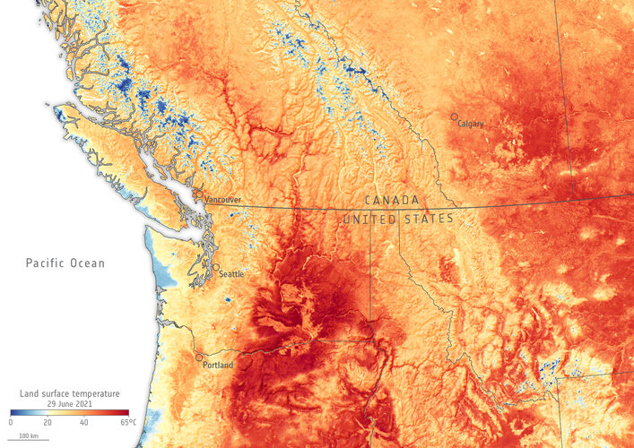 Image:
The heatwave now hitting parts of western Canada and the US has been particularly devastating. This Copernicus Sentinel-3 image shows land surface temperature.
Image:
The heatwave now hitting parts of western Canada and the US has been particularly devastating. This Copernicus Sentinel-3 image shows land surface temperature.
20210628 - odstávka ISÚI a VDP
1.7.2021 16:43 ČÚZK /ruian/Novinky-RUIAN/Archiv-novinek-RUIAN/2021/20210628-odstavka-ISUI-a-VDPNedostupné produkční prostředí ISÚI
1.7.2021 14:15 ČÚZK /ruian/Editacni-agendovy-system-ISUI/Provozni-informace-a-odstavky/Archiv-PROD/Nedostupne-produkcni-prostredi-ISUI-(21)Nedostupný VDP
1.7.2021 14:15 ČÚZK /ruian/Editacni-agendovy-system-ISUI/Provozni-informace-a-odstavky/Archiv-PROD/Nedostupny-VDPNedostupné produkční prostředí ISÚI
1.7.2021 14:14 ČÚZK /ruian/Editacni-agendovy-system-ISUI/Provozni-informace-a-odstavky/Archiv-PROD/Nedostupne-produkcni-prostredi-ISUI-(20)Úprava šifrovacích algoritmů SSL
1.7.2021 14:14 ČÚZK /ruian/Editacni-agendovy-system-ISUI/Provozni-informace-a-odstavky/Archiv-PROD/Uprava-sifrovacich-algoritmu-SSLNedostupné produkční prostředí ISÚI
1.7.2021 14:13 ČÚZK /ruian/Editacni-agendovy-system-ISUI/Provozni-informace-a-odstavky/Archiv-PROD/Nedostupne-produkcni-prostredi-ISUI-(19)Nedostupné produkční prostředí ISÚI
1.7.2021 14:13 ČÚZK /ruian/Editacni-agendovy-system-ISUI/Provozni-informace-a-odstavky/Archiv-PROD/Nedostupne-produkcni-prostredi-ISUI-(18)Nedostupné produkční prostředí ISÚI
1.7.2021 14:12 ČÚZK /ruian/Editacni-agendovy-system-ISUI/Provozni-informace-a-odstavky/Archiv-PROD/Nedostupne-produkcni-prostredi-ISUI-(17)Nedostupné produkční prostředí ISÚI
1.7.2021 14:12 ČÚZK /ruian/Editacni-agendovy-system-ISUI/Provozni-informace-a-odstavky/Archiv-PROD/Nedostupne-produkcni-prostredi-ISUI-(16)Nedostupné produkční prostředí ISÚI
1.7.2021 14:11 ČÚZK /ruian/Editacni-agendovy-system-ISUI/Provozni-informace-a-odstavky/Archiv-PROD/Nedostupne-produkcni-prostredi-ISUI-(15)Nedostupné produkční prostředí ISÚI
1.7.2021 14:11 ČÚZK /ruian/Editacni-agendovy-system-ISUI/Provozni-informace-a-odstavky/Archiv-PROD/Nedostupne-produkcni-prostredi-ISUI-(14)Nedostupné produkční prostředí ISÚI
1.7.2021 14:11 ČÚZK /ruian/Editacni-agendovy-system-ISUI/Provozni-informace-a-odstavky/Archiv-PROD/Nedostupne-produkcni-prostredi-ISUI-(13)Nedostupné produkční prostředí ISÚI
1.7.2021 14:10 ČÚZK /ruian/Editacni-agendovy-system-ISUI/Provozni-informace-a-odstavky/Archiv-PROD/Nedostupne-produkcni-prostredi-ISUI-(12)Nedostupné produkční prostředí ISÚI
1.7.2021 14:10 ČÚZK /ruian/Editacni-agendovy-system-ISUI/Provozni-informace-a-odstavky/Archiv-PROD/Nedostupne-produkcni-prostredi-ISUI-(11)Nedostupné produkční prostředí ISÚI
1.7.2021 14:10 ČÚZK /ruian/Editacni-agendovy-system-ISUI/Provozni-informace-a-odstavky/Archiv-PROD/Nedostupne-produkcni-prostredi-ISUI-(10)Nedostupné produkční prostředí ISÚI
1.7.2021 14:09 ČÚZK /ruian/Editacni-agendovy-system-ISUI/Provozni-informace-a-odstavky/Archiv-PROD/Nedostupne-produkcni-prostredi-ISUI-(9)Nedostupné produkční prostředí ISÚI
1.7.2021 14:09 ČÚZK /ruian/Editacni-agendovy-system-ISUI/Provozni-informace-a-odstavky/Archiv-PROD/Nedostupne-produkcni-prostredi-ISUI-(8)Nedostupné produkční prostředí ISÚI
1.7.2021 14:08 ČÚZK /ruian/Editacni-agendovy-system-ISUI/Provozni-informace-a-odstavky/Archiv-PROD/Nedostupne-produkcni-prostredi-ISUI-(7)Nedostupné produkční prostředí ISÚI
1.7.2021 14:03 ČÚZK /ruian/Editacni-agendovy-system-ISUI/Provozni-informace-a-odstavky/Archiv-PROD/Nedostupne-produkcni-prostredi-ISUI-(6)Nedostupné produkční prostředí ISÚI
1.7.2021 14:03 ČÚZK /ruian/Editacni-agendovy-system-ISUI/Provozni-informace-a-odstavky/Archiv-PROD/Nedostupne-testovaci-prostredi-ISUINedostupné testovací prostředí ISÚI
1.7.2021 14:03 ČÚZK /ruian/Editacni-agendovy-system-ISUI/Provozni-informace-a-odstavky/Archiv-PROD/Nedostupne-testovaci-prostredi-ISUINedostupné produkční prostředí ISÚI
1.7.2021 14:02 ČÚZK /ruian/Editacni-agendovy-system-ISUI/Provozni-informace-a-odstavky/Archiv-PROD/Nedostupne-produkcni-prostredi-ISUI-(5)Nedostupné produkční prostředí ISÚI
1.7.2021 14:02 ČÚZK /ruian/Editacni-agendovy-system-ISUI/Provozni-informace-a-odstavky/Archiv-PROD/Nedostupne-produkcni-prostredi-ISUI-(4)Nedostupné produkční prostředí ISÚI
1.7.2021 14:01 ČÚZK /ruian/Editacni-agendovy-system-ISUI/Provozni-informace-a-odstavky/Archiv-PROD/Nedostupne-produkcni-prostredi-ISUI-(3)Nedostupné testovací prostředí ISÚI
1.7.2021 13:45 ČÚZK /ruian/Editacni-agendovy-system-ISUI/Provozni-informace-a-odstavky/Archiv-REF3/Nedostupne-testovaci-prostredi-ISUINedostupné produkční prostředí ISÚI
1.7.2021 13:43 ČÚZK /ruian/Editacni-agendovy-system-ISUI/Provozni-informace-a-odstavky/Archiv-PROD/Nedostupne-produkcni-prostredi-ISUI-(2)Oznámení o provozu KP TU
1.7.2021 13:16 ČÚZK - předpisy a opatření Katastrální úřad pro Královéhradecký kraj - Katastrální pracoviště Trutnov zveřejnil novou aktualitu: OZNÁMENÍo provozu katastrálního pracoviště
Od 01.07.2021 do 28.02.2023 bude probíhat postupná rekonstrukce interiéru budovy katastrálního pracoviště po dílčích etapách, vždy v rozsahu jednoho nadzemního podlaží. Budova zůstává otevřena pro veřejnost v plném rozsahu, byť při omezení stavbou. Věříme, že po dobu stavebních prací nedojde při provádění stavebního záměru k žádnému nežádoucímu jevu, který by ovlivnil poskytování služeb veřejnosti.
Více informací v příloze.
Oznámení o provozu KP TU
1.7.2021 13:16 ČÚZK /Urady/Katastralni-urady/Katastralni-urady/Katastralni-urad-pro-Kralovehradecky-kraj/Katastralni-pracoviste/KP-Trutnov/O-uradu/Aktuality/Oznameni-o-provozu-KP-TUOmezení provozu WSGP
1.7.2021 10:24 ČÚZK /Zememerictvi/Zememericke-cinnosti/Aktuality-pro-zememerice/2021/Omezeni-provozu-WSGPOmezení provozu WSGP
1.7.2021 10:24 ČÚZK - RSS kanál pro zeměměřiče Upozorňujeme, že od pátku 2.7.2021 14:30 dojde z provozních důvodů k přerušení provozu Webové služby pro vyhotovitele a ověřovatele geometrických plánů (WSGP). Obnovení provozu se předpokládá v průběhu úterý 6.7.2021. Počítejte, prosím, s tímto omezením při přípravě podkladů pro měření. Omlouváme se za komplikace a děkujeme za pochopení.Omezení provozu WSGP
1.7.2021 10:24 ČÚZK - předpisy a opatření Český úřad zeměměřický a katastrálnízveřejnil novou aktualitu: Upozorňujeme, že od pátku 2.7.2021 14:30 dojde z provozních důvodů k přerušení provozu Webové služby pro vyhotovitele a ověřovatele geometrických plánů (WSGP). Obnovení provozu se předpokládá v průběhu úterý 6.7.2021. Počítejte, prosím, s tímto omezením při přípravě podkladů pro měření. Omlouváme se za komplikace a děkujeme za pochopení.
Primis během dvou dnů letecky nasnímkoval Vídeň
1.7.2021 9:59 GeoBusinessFirma Primis oznámila, že v prvních jarních dnech, přesněji během 25. a 26. března 2021, letecky nasnímkovala celé hlavní město Rakouska. Vídeň má rozlohu 586 čtverečních kilometrů, což při velikosti pixelu 6 cm dalo dohromady vytvořilo téměř šest tisíc leteckých snímků. Tyto snímky pak zabírají na datových nosičích celých 22 terabajtů. V tomto případě slouží […]
The post Primis během dvou dnů letecky nasnímkoval Vídeň appeared first on GeoBusiness.
D-Orbit’s ION Satellite Carrier Rides to Space atop SpaceX’s Falcon 9 rocket
1.7.2021 2:50 GISCafe.com Webcasts-Webinars FINO MORNASCO, Italy, June 30, 2021 (GLOBE NEWSWIRE) -- D-Orbit, a leader in the space logistics and orbital transportation industry, announced …Satellogic Launches 4 Additional Satellites on SpaceX Falcon 9 Rocket
1.7.2021 2:50 GISCafe.com Webcasts-Webinars Satellogic’s 10th mission, launching from Cape Canaveral Space Force Station, increases the company’s industry leading capacity for …Parrot unveils ANAFI Ai: The first 4G connected robotic UAV
1.7.2021 0:49 GISCafe.com Webcasts-Webinars ANAFI Ai provides professionals features that really matter.PARIS, June 30, 2021 — (PRNewswire) — Parrot, a leading European drone …
Cyclomedia Awarded RFP for City of Alexandria
30.6.2021 20:51 GISCafe.com Webcasts-Webinars Enabling Citywide Right of Way Asset ManagementSAN RAFAEL, Calif., June 30, 2021 — (PRNewswire) — Cyclomedia, the leading provider …
Více než 200 zeměměřických a astronomických přístrojů na výstavě Jak se měří svět v pražském NTM
30.6.2021 18:26 ZeměměřičV Národním technickém muzeu se koná nová výstava Jak se měří svět. Zhlédnout ji můžete až do konce února 2022. Výstava představuje staré a současné přístroje: dalekohledy, sluneční i astronomické hodiny, teodolity, námořní sextanty, nivelační přístroje, totální stanice, fotogrammetrické komory, pasážníky, délkové etalony, navigační stanice GPS a mnoho dalších. Je vystaveno více jak dvě stě přístrojů a pomůcek z astronomie […]
The post Více než 200 zeměměřických a astronomických přístrojů na výstavě Jak se měří svět v pražském NTM appeared first on Zeměměřič.
OpenStreetMap zvažuje přesun do Evropy
30.6.2021 18:12 GeoBusinessNadace OpenStreetMap, stojící za provozem stejnojmenného mapového webu, zvažuje odchod z Velké Británie. OpenStreetMap, kterou téměř před dvaceti lety založil britský podnikatel Steve Coast, hledá novou základnu své nadace. Britský deník The Guardian cituje nadačního pokladníka Guillaume Rischarda, který říká, že “There is not one reason for moving, but a multitude of paper cuts, most […]
The post OpenStreetMap zvažuje přesun do Evropy appeared first on GeoBusiness.
DarkPulse, Inc. Announces Letter of Intent to Acquire TerraData Unmanned, PLLC, a Drone Based Company Offering Multiple Platforms Including Underwater Capabilities
30.6.2021 17:11 GISCafe.com Webcasts-Webinars NEW YORK, June 30, 2021 (GLOBE NEWSWIRE) -- Dark Pulse, Inc. (OTC Markets: DPLS) (“DarkPulse” and the “Company”), a technology company …EUSPA Administrative Board team completed with the election of the new Deputy Chair
30.6.2021 16:50 European GNSS Agency
On 28 June 2021, EU Member States representatives elected Juan Manuel del Salvador Codosero Bolaños as the new Deputy Chair of the EUSPA Administrative Board. It followed the election of the AB Chair, Václav Kobera, in mid-June.
Representatives from the European Union Member States and the European Commission gathered on 28 June 2021 to elect the new Deputy Chair of the EUSPA Administrative Board.
The new EUSPA AB Deputy Chair, Juan Manuel del Salvador Codosero Bolaños is a Spanish national and aeronautical engineer specialized in jet engines with an extensive experience in both the public and private sector in areas related to aviation and aerospace.
Codosero Bolaños and the newly appointed Chair, Vaclav Kobera reaffirmed their commitment to be working together with all EU Member States to equally spread the benefits of the EU Space Programme across the Union. Transparency in decision making will continue being the cornerstone of the processes of the EUSPA Administrative Board (AB).
Read this: New Chair for the EUSPA Administrative Board
“I am glad to have received the trust of my colleagues to take this role. I want to get EUSPA closer to the Member States. I will use my mandate as a lever to boost the participation of the Member States in EUSPA daily work and leverage the EUSPA activities in the Member States administration,” said Codosero Bolaños.
“I would like to congratulate Mr Codosero Bolaños on his election. There is a lot of work ahead of us and I am happy to have him on board. We need an active approach from all our AB colleagues. Their interest and commitment are essential to implement the EU Space Programme. We will try our best to increase coordination, cooperation and communication and secure openness and transparency as the main values on this EU space journey,” stated Kobera.
“I would also like to salute Mr Codosero Bolaños on his election. With the elections of Mr. Kobera as the Administrative Board Chair and Mr. Codosero as Deputy Chair, our Board’s leadership is now in place, and it will surely be instrumental in the delivery of the EU Space Programme. I look forward to seeing all AB Members participating in this journey of establishing a state-of-the-art, robust space EU Agency for the Space Programme,” concluded Rodrigo da Costa, EUSPA Executive Director.
Read the Czech version here: Tým správní rady EUSPA byl doplněn o nově zvoleného místopředsedu
Read the Spanish version here: El Consejo de Administración de la EUSPA se completa con la elección del nuevo Vicepresidente
Media note: This feature can be republished without charge provided the European Union Agency for the Space Programme (EUSPA) is acknowledged as the source at the top or the bottom of the story. You must request permission before you use any of the photographs on the site. If you republish, we would be grateful if you could link back to the EUSPA website (http://www.euspa.europa.eu).
Rand McNally Names Aaron Dannenbring Chief Executive Officer
30.6.2021 15:53 GISCafe.com Webcasts-Webinars The former HERE Technologies executive brings a track record of innovationCHICAGO, June 30, 2021 – Rand McNally, a leader in mapping, …
Canadian Space Tech Companies Partner to Deliver Next-Generation Earth Observation Data
30.6.2021 15:53 GISCafe.com Webcasts-Webinars WATERLOO, ON, June 30, 2021 — (PRNewswire) — SkyWatch Space Applications Inc. ("SkyWatch"), a Waterloo-based space technology startup, …Dedrone Protects Preakness 146 from Drone Threats
30.6.2021 15:53 GISCafe.com Webcasts-Webinars Return of Live Events Signals New Era in Event Airspace SecuritySAN FRANCISCO, June 30, 2021 — (PRNewswire) — Dedrone, the market …
Volatus Aerospace Acquires ConnexiCore to Expand Drone Services Business into the US
30.6.2021 15:53 GISCafe.com Webcasts-Webinars The acquisition will create the largest and most comprehensive drone services provider in North America, with a pilot network blanketing Canada and …Nedostupné produkční prostředí ISÚI
30.6.2021 15:27 ČÚZK /ruian/Editacni-agendovy-system-ISUI/Provozni-informace-a-odstavky/Archiv-PROD/Nedostupne-produkcni-prostredi-ISUI-(1)Nedostupné produkční prostředí ISÚI
30.6.2021 15:27 ČÚZK /ruian/Editacni-agendovy-system-ISUI/Provozni-informace-a-odstavky/Archiv-PROD/Nedostupne-produkcni-prostredi-ISUIUpozorňujeme naše uživatele, ž
30.6.2021 14:59 GEUSware Upozorňujeme naše uživatele, že ČÚZK od pátku 2.7.2021 od 14:30 přibližně do úterý 6.7.2021 zcela přeruší provoz Webových služeb pro geodety. Z tohoto důvodu budou v GEUSu nefunkční Podklady měření a Odesílání GP.Kartograf/ka
30.6.2021 14:56 ČÚZK - předpisy a opatření Zeměměřický úřadvypisuje výběrové řízení na místo
Kartograf/ka
Kartograf/ka
30.6.2021 14:56 Zeměměřický úřad Zeměměřický úřadvypisuje výběrové řízení na místo
Kartograf/ka
Kartograf/ka
30.6.2021 14:56 ČÚZK - volná místa Zeměměřický úřad vypisuje výběrové řízení na místo Kartograf/kaZáznamy webových seminářů k ArcGIS Pro
30.6.2021 14:16 ARCDATABěhem jara jsme odvysílali celkem sedm webových seminářů, ve kterých jsme se na aplikaci ArcGIS Pro podívali z mnoha různých úhlů – od běžných úloh přes možnosti práce s rastrovými daty až po automatizaci nejrůznějších činností. Vedle toho jsme zde představili i novou generaci aplikace ArcGIS Online Map Viewer.
Na těchto webových seminářích jsme přivítali bezmála 900 účastníků a odpověděli na 160 nejrůznějších dotazů – veškeré otázky a odpovědi, které během jednotlivých seminářů zazněly, naleznete na diskusním fóru Esri Community.
Nestihli jste vše? Podívejte se na záznam
Rada/odborný rada v oddělení právních vztahů k nemovitostem na Katastrálním pracovišti Hustopeče
30.6.2021 14:13 ČÚZK - volná místa Katastrální úřad pro Jihomoravský kraj Katastrální pracoviště Hustopeče vypisuje výběrové řízení na místo Rada/odborný rada v oddělení právních vztahů k nemovitostem na Katastrálním pracovišti HustopečeRada/odborný rada v oddělení právních vztahů k nemovitostem na Katastrálním pracovišti Hustopeče
30.6.2021 14:13 ČÚZK - předpisy a opatření Katastrální úřad pro Jihomoravský kraj Katastrální pracoviště Hustopečevypisuje výběrové řízení na místo
Rada/odborný rada v oddělení právních vztahů k nemovitostem na Katastrálním pracovišti Hustopeče
Rada/odborný rada v oddělení právních vztahů k nemovitostem na Katastrálním pracovišti Hustopeče
30.6.2021 14:13 ČÚZK /Urady/Katastralni-urady/Katastralni-urady/Katastralni-urad-pro-Jihomoravsky-kraj/Volna-mista/DMS/Rada-odborny-rada-v-oddeleni-pravnich-vztahu-k-nemUnicorn nasadil pro CETIN řešení pro plánování výstavby optických sítí
30.6.2021 12:17 Unicorn Společnost Unicorn úspěšně dokončila první etapu implementace softwarového řešení založeného na produktu holandského partnera Geostruct IMS, který se právě zaměřuje na podporu plánování a FTTx sítí. Budování vysokorychlostních přístupových optických sítí je pro telekomunikační společnost CETIN jednou z hlavních priorit z pohledu investic v nejbližších letech. Můžeme se tak těšit na stále rostoucí nabídku služeb založených na optickém vlákně vedoucím přímo do domácností. To ovšem vyžaduje zajistit naplánování a realizaci velkého množství investičních akcí, což se neobjede bez systémové podpory a automatizace projektování.vedení katastrální mapy
30.6.2021 12:06 ČÚZK - předpisy a opatření Katastrální úřad pro Olomoucký kraj - Katastrální pracoviště Šumperkvypisuje výběrové řízení na místo
vedení katastrální mapy
vedení katastrální mapy
30.6.2021 12:06 ČÚZK /Urady/Katastralni-urady/Katastralni-urady/Katastralni-urad-pro-Olomoucky-kraj/Volna-mista/vedeni-katastralni-mapyvedení katastrální mapy
30.6.2021 12:06 ČÚZK - volná místa Katastrální úřad pro Olomoucký kraj - Katastrální pracoviště Šumperk vypisuje výběrové řízení na místo vedení katastrální mapyShoemaker Crater, Australia
30.6.2021 10:30 ESA Observing the Earth Image:
For Asteroid Day, the Copernicus Sentinel-2 mission takes us over the Shoemaker Impact Structure (formerly known as Teague Ring) in Western Australia.
Image:
For Asteroid Day, the Copernicus Sentinel-2 mission takes us over the Shoemaker Impact Structure (formerly known as Teague Ring) in Western Australia.
Odborný referent – vedení katastrální mapy
30.6.2021 9:20 ČÚZK - volná místa Katastrální úřad pro Moravskoslezský kraj Katastrální pracoviště Třinec vypisuje výběrové řízení na místo Odborný referent – vedení katastrální mapyOdborný referent – vedení katastrální mapy
30.6.2021 9:20 ČÚZK - předpisy a opatření Katastrální úřad pro Moravskoslezský kraj Katastrální pracoviště Třinecvypisuje výběrové řízení na místo
Odborný referent – vedení katastrální mapy
Odborný referent – vedení katastrální mapy
30.6.2021 9:20 ČÚZK /Urady/Katastralni-urady/Katastralni-urady/Katastralni-urad-pro-Moravskoslezsky-kraj/Uredni-deska/Oznameni-a-jina-uredni-sdeleni/Volna-mista/DMS/Odborny-referent-–-vedeni-katastralni-mapyVrchní referent/rada – kontrola aktualizace
30.6.2021 9:11 ČÚZK - volná místa Katastrální úřad pro Moravskoslezský kraj Katastrální pracoviště Ostrava vypisuje výběrové řízení na místo Vrchní referent/rada – kontrola aktualizaceVrchní referent/rada – kontrola aktualizace
30.6.2021 9:11 ČÚZK /Urady/Katastralni-urady/Katastralni-urady/Katastralni-urad-pro-Moravskoslezsky-kraj/Uredni-deska/Oznameni-a-jina-uredni-sdeleni/Volna-mista/DMS/Vrchni-referent-rada-–-kontrola-aktualizaceVrchní referent/rada – kontrola aktualizace
30.6.2021 9:11 ČÚZK - předpisy a opatření Katastrální úřad pro Moravskoslezský kraj Katastrální pracoviště Ostravavypisuje výběrové řízení na místo
Vrchní referent/rada – kontrola aktualizace
Odborný referent/vrchní referent – obnova katastrálního operátu
30.6.2021 9:06 ČÚZK - předpisy a opatření Katastrální úřad pro Moravskoslezský kraj Katastrální pracoviště Opavavypisuje výběrové řízení na místo
Odborný referent/vrchní referent – obnova katastrálního operátu
Odborný referent/vrchní referent – obnova katastrálního operátu
30.6.2021 9:06 ČÚZK /Urady/Katastralni-urady/Katastralni-urady/Katastralni-urad-pro-Moravskoslezsky-kraj/Uredni-deska/Oznameni-a-jina-uredni-sdeleni/Volna-mista/DMS/Odborny-referent-vrchni-referent-–-obnova-kata-(1)Odborný referent/vrchní referent – obnova katastrálního operátu
30.6.2021 9:06 ČÚZK - volná místa Katastrální úřad pro Moravskoslezský kraj Katastrální pracoviště Opava vypisuje výběrové řízení na místo Odborný referent/vrchní referent – obnova katastrálního operátuVrchní referent/rada – obnova katastrálního operátu
30.6.2021 9:02 ČÚZK - volná místa Katastrální úřad pro Moravskoslezský kraj Katastrální pracoviště Opava vypisuje výběrové řízení na místo Vrchní referent/rada – obnova katastrálního operátuVrchní referent/rada – obnova katastrálního operátu
30.6.2021 9:02 ČÚZK - předpisy a opatření Katastrální úřad pro Moravskoslezský kraj Katastrální pracoviště Opavavypisuje výběrové řízení na místo
Vrchní referent/rada – obnova katastrálního operátu
Rada/odborný rada – obnova katastrálního operátu
30.6.2021 8:58 ČÚZK - předpisy a opatření Katastrální úřad pro Moravskoslezský kraj Katastrální pracoviště Nový Jičínvypisuje výběrové řízení na místo
Rada/odborný rada – obnova katastrálního operátu