


![]()

zprávy
zdroje zpráv:ICEYE Expands Satellite Offering in Japan, Makoto Higashi Joins as General Manager for Local Business Operations
23.6.2021 16:35 GISCafe.com Webcasts-Webinars HELSINKI, Finland, June 23, 2021 — (PRNewswire) — ICEYE, the global leader in persistent monitoring of the Earth with radar …HSR.health Awarded Funding to Pilot Global Disease Surveillance System
23.6.2021 16:35 GISCafe.com Webcasts-Webinars Funding further validates the firm's innovative AI-based geospatial solutions supporting global health emergency response efforts.ROCKVILLE, Md., …
Luokung Announces Approval of eMapGo's HD Map Standards
23.6.2021 16:35 GISCafe.com Webcasts-Webinars BEIJING, June 23, 2021 — (PRNewswire) — Luokung Technology Corp. (NASDAQ: LKCO) ("Luokung" or the "Company"), a leading …20170306 - Zveřejnění prezentací
23.6.2021 15:45 ČÚZK /ruian/Editacni-agendovy-system-ISUI/Editacni-webove-sluzby-ISUI/Archiv-novinky/20170306-Zverejneni-prezentaci20190102 - Aktualizace dokumentů
23.6.2021 15:45 ČÚZK /ruian/Editacni-agendovy-system-ISUI/Editacni-webove-sluzby-ISUI/Archiv-novinky/20190102-Aktualizace-dokumentu20170131 - Pracovní seminář "Webové služby ISÚI/RÚIAN"
23.6.2021 15:45 ČÚZK /ruian/Editacni-agendovy-system-ISUI/Editacni-webove-sluzby-ISUI/Archiv-novinky/20170131-Pracovni-seminar-Webove-sluzby-ISUI-RUIAN20160429 - Vystavení dokumentace k EWS
23.6.2021 15:45 ČÚZK /ruian/Editacni-agendovy-system-ISUI/Editacni-webove-sluzby-ISUI/Archiv-novinky/15-11-201320161213 - aktualizace XSD k verzi 2.1
23.6.2021 15:45 ČÚZK /ruian/Editacni-agendovy-system-ISUI/Editacni-webove-sluzby-ISUI/Archiv-novinky/20161213-aktualizace-XSD-k-verzi-2-120160907 - Zveřejnění plánovaných XSD, verze RÚIAN 2.0.1
23.6.2021 15:45 ČÚZK /ruian/Editacni-agendovy-system-ISUI/Editacni-webove-sluzby-ISUI/Archiv-novinky/Zverejneni-planovanych-XSD,-verze-RUIAN-2-0-120190531 - Vyhlášení výsledků voleb
23.6.2021 15:43 ČÚZK /ruian/Ucelove-uzemni-prvky/Volebni-okrsky/Archiv-novinky/20190531-Vyhlaseni-vysledku-voleb20190117 - Uzamčení volebních okrsků v ISÚI
23.6.2021 15:43 ČÚZK /ruian/Ucelove-uzemni-prvky/Volebni-okrsky/Archiv-novinky/20190117-Uzamceni-volebnich-okrsku-v-ISUI24.11.2013
23.6.2021 15:43 ČÚZK /ruian/Ucelove-uzemni-prvky/Volebni-okrsky/Archiv-novinky/18-11-201320180202 - Vyhlášení výsledků voleb
23.6.2021 15:43 ČÚZK /ruian/Ucelove-uzemni-prvky/Volebni-okrsky/Archiv-novinky/20180202-Vyhlaseni-vysledku-voleb20200415 - uzamčení volebních okrsků
23.6.2021 15:43 ČÚZK /ruian/Ucelove-uzemni-prvky/Volebni-okrsky/Archiv-novinky/20191016-Odstavka-systemu20180531 - Uzamčení volebních okrsků v ISÚI
23.6.2021 15:43 ČÚZK /ruian/Ucelove-uzemni-prvky/Volebni-okrsky/Archiv-novinky/20180531-Uzamceni-volebnich-okrsku-v-ISUI22.11.2013
23.6.2021 15:43 ČÚZK /ruian/Ucelove-uzemni-prvky/Volebni-okrsky/Archiv-novinky/26-11-201320172510 - Uzamčení volebních okrsků v ISÚI
23.6.2021 15:43 ČÚZK /ruian/Ucelove-uzemni-prvky/Volebni-okrsky/Archiv-novinky/20172510-Uzamceni-volebnich-okrsku-v-ISUI20170502 - Uzamčení VO v ISÚI
23.6.2021 15:43 ČÚZK /ruian/Ucelove-uzemni-prvky/Volebni-okrsky/Archiv-novinky/20170502-Uzamceni-VO-v-ISUI20150625 - Registrace agendy A1281
23.6.2021 15:43 ČÚZK /ruian/Ucelove-uzemni-prvky/Volebni-okrsky/Archiv-novinky/20150625-Registrace-agendy-A128115.11.2013
23.6.2021 15:43 ČÚZK /ruian/Ucelove-uzemni-prvky/Volebni-okrsky/Archiv-novinky/15-11-201320160421 - Uzamčení volebních okrsků Ministerstvem vnitra
23.6.2021 15:43 ČÚZK /ruian/Ucelove-uzemni-prvky/Volebni-okrsky/Archiv-novinky/Uzamceni-volebnich-okrsku-Ministerstvem-vnitra16.11.2013
23.6.2021 15:43 ČÚZK /ruian/Ucelove-uzemni-prvky/Volebni-okrsky/Archiv-novinky/16-11-2013Odborný referent/Vrchní referent – Oddělení aktualizace katastru nemovitostí
23.6.2021 14:23 ČÚZK /Urady/Katastralni-urady/Katastralni-urady/Katastralni-urad-pro-Karlovarsky-kraj/Uredni-deska/Oznameni-a-jina-uredni-sdeleni/Volna-mista/DMS/Odborny-referent-Vrchni-referent-–-Oddeleni-aktualOdborný referent/Vrchní referent – Oddělení aktualizace katastru nemovitostí
23.6.2021 14:23 ČÚZK - volná místa Katastrální úřad pro Karlovarský kraj Katastrální pracoviště Karlovy Vary vypisuje výběrové řízení na místo Odborný referent/Vrchní referent – Oddělení aktualizace katastru nemovitostíOdborný referent/Vrchní referent – Oddělení aktualizace katastru nemovitostí
23.6.2021 14:23 ČÚZK - předpisy a opatření Katastrální úřad pro Karlovarský kraj Katastrální pracoviště Karlovy Varyvypisuje výběrové řízení na místo
Odborný referent/Vrchní referent – Oddělení aktualizace katastru nemovitostí
Odborný referent v oddělení aktualizace a dokumentace Katastrálního pracoviště Děčín - Místo je dle
23.6.2021 14:21 ČÚZK - předpisy a opatření Katastrální úřad pro Ústecký kraj Katastrální pracoviště Děčínvypisuje výběrové řízení na místo
Odborný referent v oddělení aktualizace a dokumentace Katastrálního pracoviště Děčín
Odborný referent v oddělení aktualizace a dokumentace Katastrálního pracoviště Děčín - Místo je dle
23.6.2021 14:21 ČÚZK - volná místa Katastrální úřad pro Ústecký kraj Katastrální pracoviště Ústí nad Labem vypisuje výběrové řízení na místo Odborný referent v oddělení aktualizace a dokumentace Katastrálního pracoviště Děčín - Místo je dleOdborný referent v oddělení aktualizace a dokumentace Katastrálního pracoviště Děčín - Místo je dle
23.6.2021 14:21 ČÚZK - volná místa Katastrální úřad pro Ústecký kraj Katastrální pracoviště Děčín vypisuje výběrové řízení na místo Odborný referent v oddělení aktualizace a dokumentace Katastrálního pracoviště Děčín - Místo je dleOdborný referent v oddělení aktualizace a dokumentace Katastrálního pracoviště Děčín - Místo je dle
23.6.2021 14:21 ČÚZK - předpisy a opatření Katastrální úřad pro Ústecký kraj Katastrální pracoviště Ústí nad Labemvypisuje výběrové řízení na místo
Odborný referent v oddělení aktualizace a dokumentace Katastrálního pracoviště Děčín - Místo je dle zákoníku práce za mateřskou a rodičovskou dovolenou
Odborný referent v oddělení aktualizace a dokumentace Katastrálního pracoviště Děčín - Místo je dle
23.6.2021 14:21 ČÚZK /Urady/Katastralni-urady/Katastralni-urady/Katastralni-urad-pro-Ustecky-kraj/Volna-mista/DMS/Odborny-referent-v-oddeleni-aktualizace-a-dokumentVedoucí oddělení aktualizace a dokumentace katastru nemovitostí Katastrálního pracoviště Ústí nad La
23.6.2021 14:16 ČÚZK - předpisy a opatření Katastrální úřad pro Ústecký kraj Katastrální pracoviště Ústí nad Labemvypisuje výběrové řízení na místo
Vedoucí oddělení aktualizace a dokumentace katastru nemovitostí Katastrálního pracoviště Ústí nad Labem
Odborný referent / vrchní referent v oddělení aktualizace a dokumentace katastru nemovitostí Katast
23.6.2021 14:11 ČÚZK - volná místa Katastrální úřad pro Ústecký kraj Katastrální pracoviště Chomutov vypisuje výběrové řízení na místo Odborný referent / vrchní referent v oddělení aktualizace a dokumentace katastru nemovitostí KatastOdborný referent / vrchní referent v oddělení aktualizace a dokumentace katastru nemovitostí Katast
23.6.2021 14:11 ČÚZK - předpisy a opatření Katastrální úřad pro Ústecký kraj Katastrální pracoviště Chomutovvypisuje výběrové řízení na místo
Odborný referent / vrchní referent v oddělení aktualizace a dokumentace katastru nemovitostí Katastrálního pracoviště Chomutov
Odborný referent / vrchní referent v oddělení právních vztahů k nemovitostem Katastrálního pracovišt
23.6.2021 14:09 ČÚZK - volná místa Katastrální úřad pro Ústecký kraj Katastrální pracoviště Děčín vypisuje výběrové řízení na místo Odborný referent / vrchní referent v oddělení právních vztahů k nemovitostem Katastrálního pracovištOdborný referent / vrchní referent v oddělení právních vztahů k nemovitostem Katastrálního pracovišt
23.6.2021 14:09 ČÚZK - předpisy a opatření Katastrální úřad pro Ústecký kraj Katastrální pracoviště Děčínvypisuje výběrové řízení na místo
Odborný referent / vrchní referent v oddělení právních vztahů k nemovitostem Katastrálního pracoviště Děčín
Konference GIS Esri v ČR 2021 bude virtuální
23.6.2021 12:08 ARCDATAUž je to více než rok, kdy pandemie COVID-19 zásadním způsobem vstoupila do našich životů. I přes to, že se svět pomalu začíná vracet do běžného režimu, nejsme v tuto chvíli schopni zaručit, že bychom se v listopadu mohli na Konferenci GIS Esri v ČR sejít tak, jako dříve. A proto jsme se i letošní konferenci rozhodli uspořádat virtuální formou.
Program konference
Už nyní se ale můžete těšit na zajímavá vystoupení hlavních řečníků, sekce věnované veřejné správě, inženýrským sítím a novinkám v technologiích, workshopy a samozřejmě také uživatelské přednášky či výstavu map a aplikací.
Uživatelské prezentace
Prezentace Vaší práce je nepostradatelnou součástí našich konferencí. Pokud tedy máte nějaký zajímavý projekt, dejte nám o něm určitě vědět a my s ním budeme při přípravě programu počítat. Přihlásit nám takto můžete přednášku, mapové dílo nebo svoji online aplikaci – to vše na adrese konference@arcdata.cz
Aktuální informace o programu a organizaci letošní konference pro vás budou dostupné na webové stránce akce.
The Sanborn Map Company, Inc. Wins Indiana Contract to Collect Statewide Digital Orthoimagery
22.6.2021 21:45 GISCafe.com Webcasts-Webinars The contract allows management of acquisition projects in accordance with Indiana’s Orthoimagery ProgramCOLORADO SPRINGS, Colo. — (BUSINESS …
WISeKey Joins Forces with Seven Leading Drone Technology Companies to Establish DRONES4SEC European Federation
22.6.2021 19:23 GISCafe.com Webcasts-Webinars WISeKey Joins Forces with Seven Leading Drone Technology Companies to Establish DRONES4SEC European Federation With drone use for public safety and …Bezdrátová profi myš CadMouse Pro firmy 3Dconnexion získala ocenění za design
22.6.2021 18:04 GeoBusinessV únoru 2015 uvedla firma 3Dconnexion na trh svoji první počítačovou myš CadMouse. Byla to první myš na světě, navržená speciálně pro projektanty, konstruktéry, architekty a umělce. O kvalitě vypovídá i to, že automobilka Audi zařadila tuto myš do standardní výbavy pracovních stanic v celé firmě. Designéři 3Dconnexion na produktu pracovali několik let a jeho […]
The post Bezdrátová profi myš CadMouse Pro firmy 3Dconnexion získala ocenění za design appeared first on GeoBusiness.
Ocenění za kvalitní design pro Profi myš CadMouse Pro firmy 3Dconnexion
22.6.2021 18:01 BIM NewsV únoru 2015 uvedla firma 3Dconnexion na trh svoji první počítačovou myš CadMouse. Byla to první myš na světě, navržená speciálně pro projektanty, konstruktéry, architekty a umělce. O kvalitě vypovídá i to, že automobilka Audi zařadila tuto myš do standardní výbavy pracovních stanic v celé firmě. Designéři 3Dconnexion na produktu pracovali několik let a jeho […]
The post Ocenění za kvalitní design pro Profi myš CadMouse Pro firmy 3Dconnexion appeared first on BIM News.
Bentley Systems kupuje firmu SPIDA Software
22.6.2021 17:38 GeoBusinessFirma Bentley Systems oznámila 14. června 2021 akvizici americké společnosti SPIDA Software, vývojáře specializovaného softwaru pro návrh, analýzu a správu systémů obslužných sloupů. SPIDA software byla založena v roce 2007 v USA ve státě Ohio, zaměstnává 26 odborníků a nabízí softwarová řešení pro modelování, simulaci a správu dat pro elektrické a komunikační nástroje a jejich […]
The post Bentley Systems kupuje firmu SPIDA Software appeared first on GeoBusiness.
Amentum Awarded $97 Million Federal Aviation Administration Environmental Remediation Support Services Contract
22.6.2021 17:30 GISCafe.com Webcasts-Webinars GERMANTOWN, Md. — (BUSINESS WIRE) — June 22, 2021 —Amentum, a leading contractor of U.S. federal and allied governments, has been …
DroneUp Selected to the FAA's BVLOS Aviation Rule Making Committee to Advance Drone Operations
22.6.2021 17:30 GISCafe.com Webcasts-Webinars VIRGINIA BEACH, Va., June 22, 2021 — (PRNewswire) — Today, DroneUp, announced that they had been selected to sit on The Federal …The new European Union Space Programme a successful European cooperation paradigm
22.6.2021 17:27 European GNSS Agency
With the largest allocated budget ever - €14.88 billion- the new EU Space Programme has now become a reality marking a new era for Europe in space. The signature of the Financial Framework Partnership Agreement (FFPA) today in Brussels anchors the European Union leadership in Space.
Why a European Union Space Programme?
With the creation of the first-ever integrated Space Programme, the European Union is reinforcing its strategy to harness the power of space to re-ignite its post-COVID economy, address climate change, transit to digitalization, and secure its autonomy and sovereignty.
The increase in the budget for the years 2021-2027, underlines the EU expectations for space as an economic enabler with a positive spillover effect across various industries. The new EU Space Programme will generate an even higher return-on-investment through the creation of value-adding, safe and secure space-based services for the EU citizens, business and governments alike. By 2025, space-related jobs across the Union should increase to 400,000.
Space data is an indispensable tool for policy-makers that helps inform policy makers and decision takers to tackle today and tomorrow’s challenges. In particular, Galileo, EGNOS and Copernicus support a wide range of EU policies ranging from the Common Fishery (CSP) to the Common Agricultural Policy (CAP) while underpinning the ambitious EU Green Deal and Europe’s digital transition.
A robust EU Space programme, secured from cyber threats and supported by a range of state-of-the-art ground centres and infrastructure ensures the Union’s autonomy and sovereignty.
European Commission, EUSPA and ESA: pieces the same space puzzle
Effective cooperation between the European Union Agency for the Space Programme (EUSPA), the European Commission and ESA is key to achieve a successful EU Space Programme. It will be measured by the benefits we deliver to the citizens and the growth we ignite in EU economy, innovation and society.
Each of the partners has unique and complementary function and competence.
The European Commission, as project manager, steers the wheel towards pressing societal, economic or environmental challenges where #EUSpace makes a difference.
EUSPA, as the EU market-oriented agency, makes sure that these challenges are addressed through the design and development of new space-based services which meet the needs of the users, while ensuring its market uptake.
ESA ensures the roll-out of new satellite technology and architecture of the systems that provide the services.
“With the signature of the Financial Framework Partnership Agreement today we have confirmed the powerful scheme together with the EC and ESA and to keep the EU Space where it belongs: at the top,” concluded Rodrigo da Costa, EUSPA Executive Director.
Media note: This feature can be republished without charge provided the European Union Agency for the Space Programme (EUSPA) is acknowledged as the source at the top or the bottom of the story. You must request permission before you use any of the photographs on the site. If you republish, we would be grateful if you could link back to the EUSPA website (http://www.euspa.europa.eu).
The new European Union Space Programme a successful European cooperation paradigm
22.6.2021 17:27 European GNSS AgencyWith the largest allocated budget ever - €14.88 billion- the new EU Space Programme has now become a reality marking a new era for Europe in space. The signature of the Financial Framework Partnership Agreement (FFPA) today in Brussels anchors the European Union leadership in Space.
Why a European Union Space Programme?
With the creation of the first-ever integrated Space Programme, the European Union is reinforcing its strategy to harness the power of space to re-ignite its post-COVID economy, address climate change, transit to digitalization, and secure its autonomy and sovereignty.
The increase in the budget for the years 2021-2027, underlines the EU expectations for space as an economic enabler with a positive spillover effect across various industries. The new EU Space Programme will generate an even higher return-on-investment through the creation of value-adding, safe and secure space-based services for the EU citizens, business and governments alike. By 2025, space-related jobs across the Union should increase to 400,000.
Space data is an indispensable tool that helps inform policy makers and decision takers to tackle today's and tomorrow’s challenges. In particular, Galileo, EGNOS and Copernicus support a wide range of EU policies ranging from the Common Fishery (CSP) to the Common Agricultural Policy (CAP) while underpinning the ambitious EU Green Deal and Europe’s digital transition.
A robust EU Space programme, secured from cyber threats and supported by a range of state-of-the-art ground centres and infrastructures ensures the Union’s autonomy and sovereignty.
European Commission, EUSPA and ESA: pieces the same space puzzle
Effective cooperation between the European Union Agency for the Space Programme (EUSPA), the European Commission and ESA is key to achieve a successful EU Space Programme. It will be measured by the benefits we deliver to the citizens and the growth we ignite in EU economy, innovation and society.
Each of the partners has unique and complementary functions and competences.
The European Commission, as project manager, steers the wheel towards pressing societal, economic or environmental challenges where EUSpace makes a difference.
EUSPA, as the EU market-oriented agency, makes sure that these challenges are addressed through the design and development of new space-based services which meet the needs of the users, while ensuring its market uptake.
ESA ensures the roll-out of new satellite technology and architecture of the systems that provide the services.
“With the signature of the Financial Framework Partnership Agreement today we have confirmed the powerful scheme together with the EC and ESA and to keep the EU Space where it belongs: at the top,” concluded Rodrigo da Costa, EUSPA Executive Director.
Media note: This feature can be republished without charge provided the European Union Agency for the Space Programme (EUSPA) is acknowledged as the source at the top or the bottom of the story. You must request permission before you use any of the photographs on the site. If you republish, we would be grateful if you could link back to the EUSPA website (http://www.euspa.europa.eu).
Jaroslav Lískovec: Průmysl 4.0 přináší zcela nové možnosti. Jsme ale teprve na začátku úžasného příběhu
22.6.2021 17:12 BIM NewsJaroslav Lískavec, ředitel Národního centra Průmyslu 4.0 říká, že s novou fází průmyslu, kterou označujeme číslovkou 4.0, „jsme teprve na začátku úžasného příběhu“.
The post Jaroslav Lískovec: Průmysl 4.0 přináší zcela nové možnosti. Jsme ale teprve na začátku úžasného příběhu appeared first on BIM News.
Jaroslav Lískovec: Průmysl 4.0 přináší zcela nové možnosti. Jsme ale teprve na začátku úžasného příběhu
22.6.2021 17:12 BIM NewsThe post Jaroslav Lískovec: Průmysl 4.0 přináší zcela nové možnosti. Jsme ale teprve na začátku úžasného příběhu appeared first on BIM News.
HERE to power global, real-time, location-based innovation for TCS DigiFleet™
22.6.2021 16:06 GISCafe.com Webcasts-Webinars HERE Technologies partners with Tata Consultancy Services to enable location-based innovation for its IoT-enabled fleet management solutionTCS …Quanergy to Publicly List Through a Business Combination With CITIC Capital Acquisition Corp. to Democratize Smart LiDAR Solutions for the Automotive and IoT Markets
22.6.2021 16:06 GISCafe.com Webcasts-Webinars Quanergy, an industry-leading provider of LiDAR sensors and 3D perception software, has entered into a definitive business combination agreement with …Velodyne Lidar, MADD Partner to Advance Understanding of Autonomous Vehicle Technology
22.6.2021 16:06 GISCafe.com Webcasts-Webinars Partnership for Promoting Safe RoadwaysSAN JOSE, Calif. — (BUSINESS WIRE) — June 22, 2021 —
Velodyne Lidar, Inc. (Nasdaq: VLDR, …
SafeGraph Announces Official Partnership with Tyler Technologies
22.6.2021 16:06 GISCafe.com Webcasts-Webinars SafeGraph partners with Tyler Technologies to provide points of interest and foot traffic data in Tyler Recovery Insights solution.DENVER, June 22, …
Ouster Now Offers Buy America and Buy American Certified Digital Lidar
22.6.2021 16:06 GISCafe.com Webcasts-Webinars Buy America(n) sensors will be manufactured in Ouster’s San Francisco facilitySAN FRANCISCO — (BUSINESS WIRE) — June 22, 2021 …
Geo Week Announces Massive Early Support for 2022 Event
22.6.2021 16:06 GISCafe.com Webcasts-Webinars Organizers of Geo Week, the single powerhouse event that champions the coming together of geospatial technologies and the built world, have announced …Překližková družice WISA Woodsat poletí do vesmíru. Koncem roku ji Evropská kosmická agentura vynese na oběžnou dráhu
22.6.2021 14:20 GeoBusinessPrvní družici, která bude vyrobena z překližky od finské firmy UPM Plywood, plánuje do vesmíru koncem roku 2021 vypustit z Nového Zélandu Evropská kosmická agentura ESA. Dodavatelem družice, nazvané WISA Woodsat, bude finská firma Arctic Astronautics. Woodsat je ve skutečnosti nano družice, označovaná také jako CubeSat o rozměrech 10 x 10 x 10 centimetrů. Michelle […]
The post Překližková družice WISA Woodsat poletí do vesmíru. Koncem roku ji Evropská kosmická agentura vynese na oběžnou dráhu appeared first on GeoBusiness.
Pasport veřejného osvětlení umí víc, než jen evidovat lampy a stožáry (2. část)
22.6.2021 12:27 T-MAPYThe post Pasport veřejného osvětlení umí víc, než jen evidovat lampy a stožáry (2. část) appeared first on T-MAPY spol. s r.o..
Pasport veřejného osvětlení umí víc, než jen evidovat lampy a stožáry (2. část)
22.6.2021 12:27 T-MAPYPasport veřejného osvětlení umí víc, než jen evidovat lampy a stožáry (1. část)
22.6.2021 11:14 T-MAPYPasport veřejného osvětlení umí víc, než jen evidovat lampy a stožáry (1. část)
22.6.2021 11:14 T-MAPYThe post Pasport veřejného osvětlení umí víc, než jen evidovat lampy a stožáry (1. část) appeared first on T-MAPY spol. s r.o..
Vychází nová verze ArcČR® 4.0
22.6.2021 10:27 blog ARCDATA Co najdete v nejnovější verzi geodatabáze ArcČR a proč obsahuje to, co obsahuje?ESA and EU celebrate a fresh start for space in Europe
22.6.2021 10:15 ESA Observing the EarthPress Release N° 20–2021
After months of constructive negotiations, ESA and EU signed today a new Financial Framework Partnership Agreement (FFPA) in a ceremony to celebrate the launch of the new EU space programme.
Interview with Kalyn Sims, CTO, Hexagon Safety & Infrastructure
22.6.2021 9:00 GISCafe.com Webcasts-WebinarsUzavření knihovního systému (12. – 31.8.2021) [Knihovna geografie, byTopic]
22.6.2021 0:00 Katedra aplikované geoinformatiky a kartografie Přf UK V rámci přechodu na nový knihovní software Alma a migraci dat bude knihovní systém Aleph mezi 12. až 31. srpnem 2021 zcela uzamčen. V této době v něm nebude možné vůbec pracovat, včetně výpůjčního protokolu. Rovněž nebude funkční jak elektronický katalog knihoven, tak i databáze GEOBIBLINE (ta bude nepřístupná až do konce září). Všechny knihovny UK budou po toto období zcela uzavřeny a nebudou tak moci potvrzovat výstupní listy zaměstnancům.Uzavření knihovního systému (12. – 31.8.2021) [Knihovna geografie, byTopic]
22.6.2021 0:00 Katedra aplikované geoinformatiky a kartografie Přf UK V rámci přechodu na nový knihovní software Alma a migraci dat bude knihovní systém Aleph mezi 12. až 31. srpnem 2021 zcela uzamčen. V této době v něm nebude možné vůbec pracovat, včetně výpůjčního protokolu. Rovněž nebude funkční jak elektronický katalog knihoven, tak i databáze GEOBIBLINE (ta bude nepřístupná až do konce září). Všechny knihovny UK budou po toto období zcela uzavřeny.Harmonogram státních závěrečných zkoušek - bakalářské studium (jaro 2021)
22.6.2021 0:00 Geografický ústav MUhttps://is.muni.cz/auth/www/herber/Harmonogram_SZZ_bc_jaro_2021_rozpis_geografie.pdf
Interview with Baptiste Jouffroy, VP of Global Sales, Aplines about Utilities asset management
21.6.2021 18:09 GISCafe.com Webcasts-WebinarsNew sea-level monitoring satellite goes live
21.6.2021 16:30 ESA Observing the Earth
Following liftoff last November and more than six months spent carefully calibrating the most advanced mission dedicated to measuring sea-level rise, Copernicus Sentinel-6 Michael Freilich is now operational – meaning that its data are available to climate researchers, ocean-weather forecasts and other data users.
NV5 Awarded $6 Million Transportation Infrastructure Contract by City of Fresno
21.6.2021 16:22 GISCafe.com Webcasts-Webinars HOLLYWOOD, Fla., June 21, 2021 (GLOBE NEWSWIRE) -- NV5 Global, Inc. (the “Company” or “NV5”) (Nasdaq: NVEE), a provider of compliance, …účetní Katastrálního úřadu pro Královéhradecký kraj
21.6.2021 14:05 ČÚZK - předpisy a opatření Katastrální úřad pro Královéhradecký kraj kancelář ředitelevypisuje výběrové řízení na místo
účetní Katastrálního úřadu pro Královéhradecký kraj
účetní Katastrálního úřadu pro Královéhradecký kraj
21.6.2021 14:05 ČÚZK - volná místa Katastrální úřad pro Královéhradecký kraj kancelář ředitele vypisuje výběrové řízení na místo účetní Katastrálního úřadu pro Královéhradecký krajúčetní Katastrálního úřadu pro Královéhradecký kraj
21.6.2021 14:05 ČÚZK /Urady/Katastralni-urady/Katastralni-urady/Katastralni-urad-pro-Kralovehradecky-kraj/Volna-mista/DMS/ucetni-Katastralniho-uradu-pro-Kralovehradecky-kraStark reality of Californian drought from space
21.6.2021 10:30 ESA Observing the Earth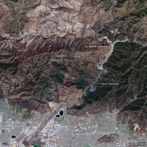 Image:
Stark reality of Californian drought from space
Image:
Stark reality of Californian drought from space
Podcast: Jak se zachraňují lesy pomocí dat z dronu?
21.6.2021 9:20 Unicorn Před třemi lety jsme se v Unicornu spojili s Českou zemědělskou univerzitou v Praze a společně vytvořili aplikaci ForestGuard, která dokáže odhalit škůdce všech smrků - kůrovce. Jak je to možné? Co je podstatou detekce? Může aplikace zachránit české lesy? Poslechněte si naše odborníky na GIS systémy, kteří vám povědí více.Take part in ESA’s Space App Camp
21.6.2021 9:20 ESA Observing the Earth
ESA is inviting up to 25 committed mobile app developers and specialists in artificial and machine learning related to observing Earth from space to join this year’s Space App Camp, which will be a virtual event over eight weeks, from 20 July to 20 September.
odborný rada - inspektor Zeměměřického a katastrálního inspektorátu v Opavě
21.6.2021 9:16 ČÚZK /Urady/Zememericke-a-katastralni-inspektoraty/Zememericke-a-katastralni-inspektoraty/Zememericky-a-katastralni-inspektorat-v-Opave/Uredni-deska/Oznameni-a-jina-uredni-sdeleni/Volna-mista/DMS/odborny-rada-inspektor-Zememerickeho-a-katastralodborný rada - inspektor Zeměměřického a katastrálního inspektorátu v Opavě
21.6.2021 9:16 ČÚZK - volná místa Zeměměřický a katastrální inspektorát v Opavě vypisuje výběrové řízení na místo odborný rada - inspektor Zeměměřického a katastrálního inspektorátu v Opavěodborný rada - inspektor Zeměměřického a katastrálního inspektorátu v Opavě
21.6.2021 9:16 ČÚZK - předpisy a opatření Zeměměřický a katastrální inspektorát v Opavěvypisuje výběrové řízení na místo odborný rada - inspektor
odborný rada - inspektor Zeměměřického a katastrálního inspektorátu v Opavě
APGEO - APG jednala s vedením Státního pozemkového úřadu
21.6.2021 2:00 Asociace podnikatelů v geomatice Vedení APG jednalo se zástupci Státního pozemkového úřadu.2G Robotics announces new name (Voyis) and leadership team
19.6.2021 3:00 GISCafe.com Webcasts-Webinars June 21, 2021 -- Leading subsea laser and imaging provider 2G Robotics has rebranded to Voyis and confirmed a new leadership team.Over the last 10+ …
2G Robotics announces new name (Voyis) and leadership team
19.6.2021 3:00 GISCafe.com Webcasts-Webinars Leading subsea laser and imaging provider 2G Robotics has rebranded to Voyis and confirmed a new leadership team.Over the last 10+ years, 2G …
SCHNEIDER ELECTRIC RELEASES ARCFM DESIGNER 11.3.1
19.6.2021 2:55 GISCafe.com Webcasts-Webinars Purpose-built for Distribution Engineers and Designers, the latest release adds revolutionary functionality for faster work and clearer insight for …Spectra Geospatial Introduces Next Generation of Field Solutions for Survey Professionals
19.6.2021 2:53 GISCafe.com Webcasts-Webinars Westminster, Colo., June 8, 2021—Spectra Geospatial introduced today the Spectra® Geospatial Origin software and the new Ranger 5 …Aplines Hosts Introduction to Risk-Based Asset Management Webinar for Electric Utilities Worldwide
19.6.2021 2:39 GISCafe.com Webcasts-Webinars Paris, France (June 15, 2021) – Aplines, an asset management software company for the electric utilities industry, announced today that it will …Vznikla platforma Stavebnictví 4.0 pro spolupráci mezi firmami a výzkumnými pracovišti
18.6.2021 16:45 BIM NewsNárodní centrum Průmyslu 4.0 založilo novou platformu „Stavebnictví 4.0“. Dohoda o spolupráci mezi výzkumnými pracovišti a stavebními firmami byla podepsána 17. června 2021 na Ministerstvu průmyslu a obchodu. Ambicí je spojit významná výzkumná pracoviště, zejména na technických univerzitách, se stavebními firmami a nabídnout prostor pro spolupráci. Bude se tak dít nejen v prostorách Českého institutu […]
The post Vznikla platforma Stavebnictví 4.0 pro spolupráci mezi firmami a výzkumnými pracovišti appeared first on BIM News.
Rada/odborný rada v oddělení aktualizace KN č.2 na Katastrálním pracovišti Znojmo
18.6.2021 11:50 ČÚZK - volná místa Katastrální úřad pro Jihomoravský kraj Katastrální pracoviště Znojmo vypisuje výběrové řízení na místo Rada/odborný rada v oddělení aktualizace KN č.2 na Katastrálním pracovišti ZnojmoRada/odborný rada v oddělení aktualizace KN č.2 na Katastrálním pracovišti Znojmo
18.6.2021 11:50 ČÚZK - předpisy a opatření Katastrální úřad pro Jihomoravský kraj Katastrální pracoviště Znojmovypisuje výběrové řízení na místo
Rada/odborný rada v oddělení aktualizace KN č.2 na Katastrálním pracovišti Znojmo