


![]()

zprávy
zdroje zpráv:Bentley Systems’ Eduardo Lazzarotto on how construction sites are being elevated by automation, software solutions, and digital twin technology
17.11.2020 18:49 Bentley SystemsPress Coverage
Construction Business News ME, Middle East
Read the articleVega flight VV17 failure: Arianespace and ESA appoint an independent Inquiry Commission
17.11.2020 18:21 ESA Observing the EarthPress Release N° 23–2020
On Tuesday 17 November, Arianespace announced the loss of the Vega VV17 mission, carrying two payloads: SEOSAT-Ingenio for ESA and TARANIS for the French space agency, CNES.
Topcon GNSS and Survey Instruments Headed to Africa to Assist Bridges to Prosperity Efforts
17.11.2020 18:08 GISCafe.com Webcasts-Webinars LIVERMORE, Calif. — (BUSINESS WIRE) — November 17, 2020 —A shipping container with several pieces of key GNSS and survey …
Fortem Technologies Announces Formation of Government Advisory Board
17.11.2020 18:08 GISCafe.com Webcasts-Webinars Pleasant Grove, Utah, Nov. 17, 2020 (GLOBE NEWSWIRE) -- Fortem Technologies, Inc., the leader in airspace security and defense for detecting and …Matternet Launches Drone Delivery Operations at Labor Berlin in Germany
17.11.2020 18:08 GISCafe.com Webcasts-Webinars New operations at Labor Berlin will initiate the first urban BVLOS medical drone delivery network in the largest city of the European Union with the …Iowa Signs Participating Addendum with DroneUp Providing Public Sector Agencies Access to Drone Services
17.11.2020 18:08 GISCafe.com Webcasts-Webinars VIRGINIA BEACH, Va., Nov. 17, 2020 — (PRNewswire) — DroneUp, LLC and the State of Iowa have signed a Participating Addendum for the …Bluesky Launches Online Streaming Service for Panoramic Aerial Images
17.11.2020 16:39 GISCafe.com Webcasts-Webinars Leicestershire, UK, 17 November 2020 – Aerial mapping company Bluesky is releasing its entire catalogue of geographically referenced oblique …KloudGin Joins Esri’s Global Ecosystem as Silver Partner
17.11.2020 16:38 GISCafe.com Webcasts-Webinars Market-Leading KloudGin AI Cloud Software Integrates Real-time Location Mapping That Streamlines Asset Management and Mobile Field Service …Alpine 4 Technologies, Ltd. (ALPP) Enters the Commercial Drone Market With its Acquisition of Impossible Aerospace Corporation
17.11.2020 16:38 GISCafe.com Webcasts-Webinars PHOENIX, Nov. 17, 2020 — (PRNewswire) — Alpine 4 Technologies, Ltd., (OTCQB: ALPP) owner of leading small market businesses, …Teledyne Optech launches new service center in Europe
17.11.2020 16:11 GISCafe.com Webcasts-Webinars Vaughan, CANADA, November 17, 2020 -- Teledyne Optech, a Teledyne Technologies [NYSE:TDY] company and global leader in advanced lidar sensors is …ArcGIS jako platforma – od otevřených dat k mapám a aplikacím (workshop)
17.11.2020 8:59 GISportal.cz
V rámci letošní virtuální Konference GIS Esri v ČR proběhne online také několik workshopů. Třetí se bude konat ve čtvrtek 19 . listopadu v čase 10.00 – 11.00. Workshopem Vás provede Matej Vrtich ze společnosti ARCDATA PRAHA, s.r.o. Abstrakt workshopu: Máte data v otevřeném formátu (JSON, CSV, …) a chtěli byste je využít ve svých […]
The post ArcGIS jako platforma – od otevřených dat k mapám a aplikacím (workshop) appeared first on GISportal.cz.

Intermap Announces Quarterly Results and Provides Business Update
17.11.2020 2:59 GISCafe.com Webcasts-Webinars DENVER, Nov. 16, 2020 — (PRNewswire) — Intermap Technologies ("Intermap" or the "Company"), a global leader in geospatial intelligence …Ten European teams selected from hundreds of proposals advance to the final phase of the Helsinki Energy Challenge
17.11.2020 1:24 GISCafe.com Webcasts-Webinars Ten teams have been selected for the final phase of the Helsinki Energy Challenge. The finalist teams highlight the international and …Úřední hodiny od 18.11.2020
16.11.2020 20:39 ČÚZK /Urady/Katastralni-urady/Katastralni-urady/Katastralni-urad-pro-Moravskoslezsky-kraj/Katastralni-pracoviste/KP-Ostrava/O-uradu/Aktuality/Uredni-hodiny-od-18-11-2020Úřední hodiny od 18.11.2020
16.11.2020 20:39 ČÚZK - předpisy a opatření Katastrální úřad pro Moravskoslezský kraj - Katastrální pracoviště Ostrava zveřejnil novou aktualitu: Od středy 18.11.2020 budou s ohledem na opatření přijatá usnesením vlády ČR č. 1080 omezeny úřední hodiny na Katastrálním pracovišti Ostrava Katastrálního úřadu pro Moravskoslezský kraj na pondělí od 8.00 do 17.00 hodin a středu od 8.00 do 17.00 hodin. I nadále upřednostňujeme bezkontaktní způsob podání (poštou, elektronicky, sběrný box). Při osobním kontaktu Vás žádáme o dodržování hygienických zásad a respektování pokynů našich zaměstnanců.Děkujeme za pochopení.
Úřední hodiny od 18.11.2020
16.11.2020 20:39 ČÚZK - předpisy a opatření Katastrální úřad pro Moravskoslezský kraj - Katastrální pracoviště Ostrava zveřejnil novou aktualitu: Od středy 18.11.2020 s ohledem na opatření přijatá usnesením vlády ČR č. 1080 budou omezeny úřední hodiny na Katastrálním pracovišti Ostrava, Katastrálního úřadu pro Moravskoslezský kraj na pondělí od 8.00 do 17.00 hodin a středu od 8.00 do 17.00 hodin. I nadále upřednostňujeme bezkontaktní způsob podání (poštou, elektronicky, sběrný box). Při osobním kontaktu Vás žádáme o dodržování hygienických zásad a respektování pokynů našich zaměstnanců.Děkujeme za pochopení.
Hexagon solutions support 13 Medellín, Colombia, public safety agencies
16.11.2020 17:14 Hexagon Safety & InfrastructureU.S. Autonomous Drone Maker Skydio Grows Momentum in Japan’s Enterprise Market With High Profile Customers
16.11.2020 16:57 GISCafe.com Webcasts-Webinars Customers include telecommunications giant NTT DOCOMO, NTT West subsidiary Japan Infra Waymark and leading drone services provider FLIGHTSTOKYO …
AgEagle Aerial Systems Reports Record Third Quarter 2020 Financial Results
16.11.2020 16:56 GISCafe.com Webcasts-Webinars WICHITA, Kan., Nov. 16, 2020 (GLOBE NEWSWIRE) -- AgEagle Aerial Systems Inc. (NYSE American: UAVS) (“AgEagle” or the “Company”), an …Enview Gains Unprecedented Momentum Following Release of Enview Explore; Demonstrates Operational Success with U.S. Air Force, Receives Strategic Contract with PACAF
16.11.2020 16:56 GISCafe.com Webcasts-Webinars SAN FRANCISCO, Nov. 16, 2020 (GLOBE NEWSWIRE) -- Enview, a pioneer in the scalable processing of 3D geospatial data, has experienced considerable …aWhere Global Daily Weather Data for Five Commodities Now Available In Bloomberg's Alternative Data Catalog
16.11.2020 16:56 GISCafe.com Webcasts-Webinars DENVER, Nov. 16, 2020 — (PRNewswire) — aWhere, Inc, a leading provider of agricultural weather data and solutions, announced that …Autodesk Kicks Off Autodesk University 2020 Digital Conference
16.11.2020 16:56 GISCafe.com Webcasts-Webinars Multi-day, interactive digital experience invites innovators from around the world to reimagine what's possibleSAN RAFAEL, Calif., Nov. 16, 2020 …
Panzura, Customers and Partners Highlight Successes and Solutions at Autodesk University Live Roundtables
16.11.2020 16:55 GISCafe.com Webcasts-Webinars Provider of World's Fastest Global File System, Panzura, Joined by Microdesk, Applied Software, U.S. CAD, ATG, Microsol and their Customers to Share …Patnácté verze softwarů MISYS včetně pasportů, KOKEŠ, PROLAND a Geoportál GEPRO přinášejí i nadále nové funkce
16.11.2020 16:37 ZeměměřičFirma GEPRO v posledních letech uvádí nové verze svých softwarů vždy na podzim, u příležitosti setkání zákazníků. Tentokrát se setkání z očividných důvodů (covid-19) nekonalo, proto se uvedení nových verzí konalo bez podrobnějšího představení. S verzemi 15 přichází nový způsob kontroly licence. Na přehledu změn v nových verzích MISYS, KOKEŠ, PROLAND i Geoportálu Gepro je vidět, že je neustále možné […]
The post Patnácté verze softwarů MISYS včetně pasportů, KOKEŠ, PROLAND a Geoportál GEPRO přinášejí i nadále nové funkce appeared first on Zeměměřič.
Patnácté verze softwarů MISYS včetně pasportů, KOKEŠ, PROLAND a Geoportál GEPRO přinášejí i nadále nové funkce
16.11.2020 16:37 ZeměměřičFirma GEPRO v posledních letech uvádí nové verze svých softwarů vždy na podzim, u příležitosti setkání zákazníků. Tentokrát se setkání z očividných důvodů (covid-19) nekonalo, proto se uvedení nových verzí konalo bez podrobnějšího představení. S verzemi 15 přichází nový způsob kontroly licence. Na přehledu změn v nových verzích MISYS, KOKEŠ, PROLAND i Geoportálu Gepro je vidět, že je neustále možné […]
The post Patnácté verze softwarů MISYS včetně pasportů, KOKEŠ, PROLAND a Geoportál GEPRO přinášejí i nadále nové funkce appeared first on Zeměměřič.
Moonlight: connecting Earth with the Moon
16.11.2020 16:30 ESA Navigation Video:
00:01:11
Video:
00:01:11
Lunar exploration relies on the extensive expertise that is on hand across ESA. As a new lunar economy emerges, it will create new opportunities involving robots, habitats and transportation. Missions to the Moon share similar communication and navigation needs that could be satisfied using a constellation of lunar satellites.
Under the agency’s "Moonlight" initiative, ESA is exploring with industry the necessary technical solutions along with delivery models for the provision of lunar telecommunication and navigation services.
Read the background article on Moonlight to learn more about the initiative.
Moonlight: connecting Earth with the Moon
16.11.2020 16:30 ESA Navigation
Video:
00:01:11
Lunar exploration relies on the extensive expertise that is on hand across ESA. As a new lunar economy emerges, it will create new opportunities involving robots, habitats and transportation. Missions to the Moon share similar communication and navigation needs that could be satisfied using a constellation of lunar satellites.
Under the agency’s "Moonlight" initiative, ESA is exploring with industry the necessary technical solutions along with delivery models for the provision of lunar telecommunication and navigation services.
Watch live: Launch of the next Earth-observing satellite SEOSAT-Ingenio
16.11.2020 13:50 ESA Observing the Earth
Watch the launch of SEOSAT-Ingenio, the Spanish high-resolution land imaging mission, on ESA Web TV on Tuesday 17 November from 02:30 CET (16 November 22:30 local time in Kourou).
Watch live: Launch of the next Earth-observing satellite SEOSAT-Ingenio
16.11.2020 13:50 ESA Observing the Earth
Update: Trajectory degraded on VV17 after first ignition of the Avum engine. Investigations on the anomaly ongoing. More to come shortly.
Watch the launch of SEOSAT-Ingenio, the Spanish high-resolution land imaging mission, on ESA Web TV on Tuesday 17 November from 02:30 CET (16 November 22:30 local time in Kourou).
Watch live: Launch of the next Earth-observing satellite SEOSAT-Ingenio
16.11.2020 13:50 ESA Observing the Earth
Watch the launch of SEOSAT-Ingenio, the Spanish high-resolution land imaging mission, on ESA Web TV on Tuesday 17 November from 02:30 CET (16 November 22:30 local time in Kourou).
Baltic ferry gathers data for self-aware sailing
16.11.2020 13:20 ESA Navigation
A day of ferry trips between Finland and Estonia became some of the best documented voyages in maritime history. Cameras, sensors, radio and satellite navigation receivers and even microphones recorded every instant of the crossings over the Baltic, gathering raw data for a new ESA-led project applying AI to the situational awareness of shipping – as an important step to full autonomy.
Online Workshop: EGNOS approaches for robust Helicopter Emergency Services
16.11.2020 13:09 European GNSS Agency
The European GNSS Agency, together with the European Helicopter Association (EHA), is organizing a joint workshop on the use of EGNOS for Helicopter Emergency Medical Services (HEMS). The online panel discussion, scheduled for Wednesday 18 November 2020 at 14:00 (CET), is open to private and public health organisations, HEMS operators, pilots, and relevant healthcare stakeholders.
Air medical services are crucial in times of crisis and emergencies,and are an integral part of many healthcare systems across the globe. Oftentimes, adverse weather conditions or other factors such as smoke cause helicopters to divert or abort landings. In addition, many hospitals lack costly ground-based helicopter navigation equipment to provide guidance in bad weather, which may lead to significant delays when time is of the essence.
Today, thanks to EGNOS, the European Satellite-Based Augmentation System, pilots can navigate through the clouds and fog, and land safely. With over 700 EGNOS-based procedures at 367 airports and helipads, the system increases safety, accessibility and efficiency for operators and pilots approaching airport and helipads in Europe.
Read this: EGNOS key for emergency and medical operations in EU COVID-19 response
With a unique lineup of EGNOS and HEMS experts, operators and service providers, the workshop, powered by the GSA and EHA, intends to familiarize attendees with the process of implementing EGNOS-based approaches for HEMS, while promoting the success-stories of EGNOS-aided HEMS operations across Europe. Participants will hear from experienced helicopter pilots explaining how to land with the enhanced vertical precision and integrity provided by the EU SBAS. Stakeholders, ranging from operators to manufacturers and instrument flight procedures designers, will complement the discussion with precious insights on the best practices and benefits deriving from implementing EGNOS procedures for hospital heliports.
This workshop is of particular interest to organisations considering the implementation of new routes or flight procedures based on EGNOS for HEMS. Participants will have the opportunity to interact with the speakers through a Q&A. To join us online, click here!
About EGNOS
EGNOS is Europe's regional satellite-based augmentation system (SBAS) that is used to improve the performance of Global Navigation Satellite Systems (GNSSs), such as GPS and in the future Galileo. EGNOS has been deployed to provide safety of life navigation services to aviation, maritime and land-based users over most of Europe.
Media note: This feature can be republished without charge provided the European GNSS Agency (GSA) is acknowledged as the source at the top or the bottom of the story. You must request permission before you use any of the photographs on the site. If you republish, we would be grateful if you could link back to the GSA website (http://www.gsa.europa.eu).
V souvislosti s vládními opatř
16.11.2020 10:19 GEUSware V souvislosti s vládními opatřeními kvůli COVID-19 je náš obchod otevřen pouze pro výdej zboží objednaného předem telefonicky, mailem či přes e-shop.Telefonní čísla a technická podpora jsou v provozu bez omezení.
Pozvánka na online GIS day na Stavebnej fakulte STU
16.11.2020 10:00 GISportal.cz
Dňa 18. novembra, celosvetovo oslavujeme medzinárodný deň geografických informačných systémov – GIS day. Ide o popularizačnú akciu, ktorej cieľom je priblížiť širokej verejnosti GIS a ich význam v bežnom živote človeka. Po minuloročnej úspešnej akcii si pre nás organizátori GIS day na Stavebnej fakulte STU v Bratislave (Katedra geodetických základov, Katedra vodného hospodárstva krajiny) pripravili online podujatie, ktorého program […]
The post Pozvánka na online GIS day na Stavebnej fakulte STU appeared first on GISportal.cz.
Konal se mezinárodní hackathon Act in Space a Aliance byla partnerem českého kola
16.11.2020 9:01 UAVATento víkend se konal ve 40ti zemích světa mezinárodní hackathon Actinspace, kde Aliance byla partnerem českého kola. V českém kole nechyběly zajímavé nápady a týmy, vše v rámci nabitého Czech Space Week, jehož součástí měla být i konference Aliance pro bezpilotní letecký průmysl. Gratulujeme vítězům. Více zde: https://www.facebook.com/ESABICPrague/posts/1223398828032007
The post Konal se mezinárodní hackathon Act in Space a Aliance byla partnerem českého kola appeared first on UAV Aliance pro bezpilotní letecký průmysl.
2. den s INSPIRE 2020 (pozvánka)
16.11.2020 8:44 GISportal.cz
Ve středu 18.11. proběhne od 10:00 do 12:00 druhý Den s INSPIRE na téma Harmonizace dat. Jak harmonizovat data pomocí programu HALE studio – praktická ukázka včetně představení návodu (CENIA).
The post 2. den s INSPIRE 2020 (pozvánka) appeared first on GISportal.cz.
Dne 14.11.2020 došlo na stránk
16.11.2020 8:14 GEUSware Dne 14.11.2020 došlo na stránkách ČÚZK k předělání aplikace Nahlížení do KN. Tato změna v GEUSu způsobila, že funkce Pomůcky/ Nahlížení do KN zadáním bodu nevrací adresy vlastníků ani v případě, kdy uživatel má nastaveno přihlášení do aplikace pomocí účtu DP. Dále nelze zobrazit přidělené řízení PGP v GP-ISKN/ Odeslání GP - WSGP.../ záložka "Řízení ZPG". Pracujeme na opravě.PhD position in geo-computational exposure assessment modeling
15.11.2020 19:45 PhD student: Developing a model of geo-computational exposure assessment for studying health effects of urban environmental risk factors in Exposome-NL (1.0 FTE) Deadline: 30 October 2020 The environment we live in has a significant impact on our health, explaining an estimated 70% of the non-communicable chronic disease burden. A large number of environmental stressors may […]PhD studentship at the intersection of GIScience and movement ecology
15.11.2020 19:44 Sonar or Magnetism: exploring bat migration using a data science approachWe are looking for a candidate for a fully-funded interdisciplinary PhD studentship at the University of St Andrews, funded by the IAPETUS Doctoral Training Programme: This project is at the intersection of GIScience and movement ecology: student will use data science to explore how migratory […]Specialista IT/programátor
15.11.2020 19:42 https://www.jobs.cz/fp/czechinvest-2684/1527790688/?positionOfAdInAgentEmail=0&searchId=7d74e7ea-4bcc-4ee6-8e24-ef62fb3a1ee2&rps=233Bergen County Adopts Geospatial Analytics® Industry-Leading Real Estate Management Program
14.11.2020 0:20 GISCafe.com Webcasts-Webinars HACKENSACK, N.J., Nov. 13, 2020 — (PRNewswire) — Officials at Bergen County, New Jersey announced that the county purchased and is …Bentley Systems to Present at the RBC Global Technology, Internet, Media & Telecom Conference
13.11.2020 20:25 Bentley SystemsEXTON, PA – November 13, 2020 – Bentley Systems, Incorporated (Nasdaq: BSY), the infrastructure engineering software company, today announced that Greg Bentley, Bentley Systems’ chief executive officer, will present virtually at the RBC Global Technology, Internet, Media & Telecom Conference on Tuesday, November 17, 2020 at approximately 4:00 p.m. Eastern time.
About Bentley Systems
Bentley Systems (Nasdaq: BSY) is the infrastructure engineering software company. We provide innovative software to advance the world’s infrastructure – sustaining both the global economy and environment. Our industry-leading software solutions are used by professionals, and organizations of every size, for the design, construction, and operations of roads and bridges, rail and transit, water and wastewater, public works and utilities, buildings and campuses, and industrial facilities. Our offerings include MicroStation-based applications for modeling and simulation, ProjectWise for project delivery, AssetWise for asset and network performance, and the iTwin platform for infrastructure digital twins. Bentley Systems employs more than 4,000 colleagues and generates annual revenues of more than $700 million in 172 countries. www.bentley.com.
Rand McNally’s DriverConnect Platform Integrated with McLeod Software’s LoadMaster®
13.11.2020 18:05 GISCafe.com Webcasts-Webinars DriverConnect devices now seamlessly integrate with the Transportation Management SystemCHICAGO, Nov. 10, 2020– Rand McNally, a leader …
Statement by Minister Garneau on inaugural National Drone Safety Awareness Day
13.11.2020 17:43 GISCafe.com Webcasts-Webinars OTTAWA, ON, Nov. 13, 2020 — (PRNewswire) —OTTAWA, ON, Nov. 13, 2020 /CNW/ - Today, the Minister of Transport, the Honourable …
Intermap Technologies Completes Private Placement
13.11.2020 17:42 GISCafe.com Webcasts-Webinars DENVER, Nov. 12, 2020 — (PRNewswire) — Intermap Technologies Corporation ("Intermap" or the "Company") today announced that it completed …Velodyne Lidar Unveils Breakthrough Solid State Sensor for Advanced Driver Assistance Systems (ADAS) and Autonomy
13.11.2020 17:42 GISCafe.com Webcasts-Webinars Available in Affordable Mass Quantities, Velarray H800 is the First in a Family of Solid State Sensors to Enhance Automakers’ Safety FeaturesSAN …
Contracts signed for three high-priority environmental missions
13.11.2020 17:30 ESA Observing the Earth
Today, ESA signed contracts with Thales Alenia Space in France and in Italy, and Airbus in Spain to build three of the new high-priority Copernicus satellite missions: CHIME, CIMR and LSTM, respectively. Each mission is set to help address different major environmental challenges such as sustainable agriculture management, food security, the monitoring of polar ice supporting the EU Integrated Policy for the Arctic, and all will be used to understand climate change.
Ways the Czech Republic benefits from the EU Space Programme
13.11.2020 16:07 European GNSS Agency
The GSA Executive Director, Rodrigo da Costa, joined the Czech Space Week to welcome the participants attending this year’s online edition. The Czech Republic is an active member of the EU Space community, and with EU Space technologies growing at an unprecedented pace, the future looks bright.
The Czech Space Week 2020 celebrates space science and technology attracting young professionals, students and space enthusiasts supported by aerospace companies, schools, museums, planetaria across the country.
The contribution of the Czech Republic to Europe’s space achievements is well-known. From Europe’s first cosmonaut -Vladimir Remek- orbiting the Earth, to becoming the hosting country of the European GNSS Agency in 2012, the Czech Republic has a long-standing history in space, leveraging #EUSpace technology to improve infrastructure, stimulate innovation, create jobs and ensure the well-being of citizens.
On the occasion of the Czech Space Week, it is worthwhile to focus on four ways, out of many, the Czech Republic is making great use of Galileo and EGNOS:
- Equipping Prague trams with state-of-the-art Galileo receivers: As part of the modernization of the city´s tram fleet, by the end of 2020, Prague trams will be benefiting from Galileo’s additional accuracy to increase network efficiency and improve user experience.
- Easing the flow of goods across EU borders: Thanks to their expertise, Czech companies have contributed to the development of the ‘’Galileo Green Lane App’’, the mobile application that facilitates the flow of freight and critical goods across the EU borders during COVID.
- Boosting innovation among the youth: Aspiring young students from the Mendel University in Brno, have joined forces with professionals from other EU countries to help develop the H2020 funded GreenPatrol project, which uses Galileo’s robust signals to perform pest detection in crops.
- Rolling out safer and cleaner forms of air travel: Six Czech airports -including Prague Vaclav Havel Airport- are more accessible even under challenging weather conditions thanks to EGNOS, the EU regional satellite navigation system. Accurate guidance by EGNOS satellites reduces the number of go-arounds (aborted landings) resulting in less noise and less emissions.
‘’The GSA’s core mission is to ensure that European citizens make the most of the European Union Space Programme. By having users in the driver seat, the agency has been able to deliver state of the art, secure satellite-based services to respond to user needs’’ says Rodrigo da Costa, GSA Executive Director.
‘’2021 will mark an important evolution for the EU Space Programme with the transformation of the GSA into the European Union Space Programme Agency, bringing new opportunities. I am sure the Czech Republic will continue to fly the EU Space Programme flag high.’’ da Costa concludes.
If you are keen on satellite navigation, Earth Observation, governmental satellite communications or simply are working in a market that can benefit from the EU Space Programme, join the European Space Week 2020. This year, the top EU space event is brought to your screens from 7th until the 11th December 2020.
Media note: This feature can be republished without charge provided the European GNSS Agency (GSA) is acknowledged as the source at the top or the bottom of the story. You must request permission before you use any of the photographs on the site. If you republish, we would be grateful if you could link back to the GSA website (http://www.gsa.europa.eu).
Ways the Czech Republic benefits from the EU Space Programme
13.11.2020 16:07 European GNSS AgencyThe GSA Executive Director, Rodrigo da Costa, joined the Czech Space Week to welcome the participants attending this year’s online edition. The Czech Republic is an active member of the EU Space community, and with EU Space technologies growing at an unprecedented pace, the future looks bright.
The Czech Space Week 2020 celebrates space science and technology attracting young professionals, students and space enthusiasts supported by aerospace companies, schools, museums, planetaria across the country.
The contribution of the Czech Republic to Europe’s space achievements is well-known. From Europe’s first cosmonaut -Vladimir Remek- orbiting the Earth, to becoming the hosting country of the European GNSS Agency in 2012, the Czech Republic has a long-standing history in space, leveraging #EUSpace technology to improve infrastructure, stimulate innovation, create jobs and ensure the well-being of citizens.
On the occasion of the Czech Space Week, it is worthwhile to focus on four ways, out of many, the Czech Republic is making great use of Galileo and EGNOS:
- Equipping Prague trams with state-of-the-art Galileo receivers: As part of the modernization of the city´s tram fleet, by the end of 2020, Prague trams will be benefiting from Galileo’s additional accuracy to increase network efficiency and improve user experience.
- Easing the flow of goods across EU borders: Thanks to their expertise, Czech companies have contributed to the development of the ‘’Galileo Green Lane App’’, the mobile application that facilitates the flow of freight and critical goods across the EU borders during COVID.
- Boosting innovation among the youth: Aspiring young students from the Mendel University in Brno, have joined forces with professionals from other EU countries to help develop the H2020 funded GreenPatrol project, which uses Galileo’s robust signals to perform pest detection in crops.
- Rolling out safer and cleaner forms of air travel: Six Czech airports -including Prague Vaclav Havel Airport- are more accessible even under challenging weather conditions thanks to EGNOS, the EU regional satellite navigation system. Accurate guidance by EGNOS satellites reduces the number of go-arounds (aborted landings) resulting in less noise and less emissions.

‘’The GSA’s core mission is to ensure that European citizens make the most of the European Union Space Programme. By having users in the driver seat, the agency has been able to deliver state of the art, secure satellite-based services to respond to user needs’’ says Rodrigo da Costa, GSA Executive Director.
‘’2021 will mark an important evolution for the EU Space Programme with the transformation of the GSA into the European Union Space Programme Agency, bringing new opportunities. I am sure the Czech Republic will continue to fly the EU Space Programme flag high.’’ da Costa concludes.
You can read here the czech version of the news.
Českou verzi článku si můžete přečíst zde.
If you are keen on satellite navigation, Earth Observation, governmental satellite communications or simply are working in a market that can benefit from the EU Space Programme, join the European Space Week 2020. This year, the top EU space event is brought to your screens from 7th until the 11th December 2020.
Media note: This feature can be republished without charge provided the European GNSS Agency (GSA) is acknowledged as the source at the top or the bottom of the story. You must request permission before you use any of the photographs on the site. If you republish, we would be grateful if you could link back to the GSA website (http://www.gsa.europa.eu).
Ways the Czech Republic benefits from the EU Space Programme
13.11.2020 16:07 European GNSS AgencyThe GSA Executive Director, Rodrigo da Costa, joined the Czech Space Week to welcome the participants attending this year’s online edition. The Czech Republic is an active member of the EU Space community, and with EU Space technologies growing at an unprecedented pace, the future looks bright.
The Czech Space Week 2020 celebrates space science and technology attracting young professionals, students and space enthusiasts supported by aerospace companies, schools, museums, planetaria across the country.
The contribution of the Czech Republic to Europe’s space achievements is well-known. From Europe’s first cosmonaut -Vladimir Remek- orbiting the Earth, to becoming the hosting country of the European GNSS Agency in 2012, the Czech Republic has a long-standing history in space, leveraging #EUSpace technology to improve infrastructure, stimulate innovation, create jobs and ensure the well-being of citizens.
On the occasion of the Czech Space Week, it is worthwhile to focus on four ways, out of many, the Czech Republic is making great use of Galileo and EGNOS:
- Equipping Prague trams with state-of-the-art Galileo receivers: As part of the modernization of the city´s tram fleet, by the end of 2020, Prague trams will be benefiting from Galileo’s additional accuracy to increase network efficiency and improve user experience.
- Easing the flow of goods across EU borders: Thanks to their expertise, Czech companies have contributed to the development of the ‘’Galileo Green Lane App’’, the mobile application that facilitates the flow of freight and critical goods across the EU borders during COVID.
- Boosting innovation among the youth: Aspiring young students from the Mendel University in Brno, have joined forces with professionals from other EU countries to help develop the H2020 funded GreenPatrol project, which uses Galileo’s robust signals to perform pest detection in crops.
- Rolling out safer and cleaner forms of air travel: Six Czech airports -including Prague Vaclav Havel Airport- are more accessible even under challenging weather conditions thanks to EGNOS, the EU regional satellite navigation system. Accurate guidance by EGNOS satellites reduces the number of go-arounds (aborted landings) resulting in less noise and less emissions.
‘’The GSA’s core mission is to ensure that European citizens make the most of the European Union Space Programme. By having users in the driver seat, the agency has been able to deliver state of the art, secure satellite-based services to respond to user needs’’ says Rodrigo da Costa, GSA Executive Director.
‘’2021 will mark an important evolution for the EU Space Programme with the transformation of the GSA into the European Union Space Programme Agency, bringing new opportunities. I am sure the Czech Republic will continue to fly the EU Space Programme flag high.’’ da Costa concludes.
If you are keen on satellite navigation, Earth Observation, governmental satellite communications or simply are working in a market that can benefit from the EU Space Programme, join the European Space Week 2020. This year, the top EU space event is brought to your screens from 7th until the 11th December 2020.
Media note: This feature can be republished without charge provided the European GNSS Agency (GSA) is acknowledged as the source at the top or the bottom of the story. You must request permission before you use any of the photographs on the site. If you republish, we would be grateful if you could link back to the GSA website (http://www.gsa.europa.eu).
Ways the Czech Republic benefits from the EU Space Programme
13.11.2020 16:07 European GNSS AgencyThe GSA Executive Director, Rodrigo da Costa, joined the Czech Space Week to welcome the participants attending this year’s online edition. The Czech Republic is an active member of the EU Space community, and with EU Space technologies growing at an unprecedented pace, the future looks bright.
The Czech Space Week 2020 celebrates space science and technology attracting young professionals, students and space enthusiasts supported by aerospace companies, schools, museums, planetaria across the country.
The contribution of the Czech Republic to Europe’s space achievements is well-known. From Europe’s first cosmonaut -Vladimir Remek- orbiting the Earth, to becoming the hosting country of the European GNSS Agency in 2012, the Czech Republic has a long-standing history in space, leveraging #EUSpace technology to improve infrastructure, stimulate innovation, create jobs and ensure the well-being of citizens.
At the occasion of the Czech Space Week, it is worthwhile to focus on four ways, out of many, the Czech Republic is making great use of Galileo and EGNOS:
- Equipping Prague trams with state-of-the-art Galileo receivers: As part of the modernization of the city´s tram fleet, by the end of 2020, Prague trams will be benefiting from Galileo’s additional accuracy to increase network efficiency and improve user experience.
- Easing the flow of goods across EU borders: Thanks to their expertise, Czech companies have contributed to the development of the ‘’Galileo Green Lane App’’, the mobile application that facilitates the flow of freight and critical goods across the EU borders during COVID.
- Boosting innovation among the youth: Aspiring young students from the Mendel University in Brno, have joined forces with professionals from other EU countries to help develop the H2020 funded GreenPatrol project, which uses Galileo’s robust signals to perform pest detection in crops.
- Rolling out safer and cleaner forms of air travel: Six Czech airports -including Prague Vaclav Havel Airport- are more accessible even under challenging weather conditions thanks to EGNOS, the EU regional satellite navigation system. Accurate guidance by EGNOS satellites reduces the number of go-arounds (aborted landings) resulting in less noise and less emissions.
‘’The GSA’s core mission is to ensure that European citizens make the most of the European Union Space Programme. By having users in the driver seat, the agency has been able to deliver state of the art, secure satellite-based services to respond to user needs’’ says Rodrigo da Costa, GSA Executive Director.
‘’2021 will mark an important evolution for the EU Space Programme with the transformation of the GSA into the European Union Space Programme Agency, bringing new opportunities. I am sure the Czech Republic will continue to fly the EU Space Programme flag high.’’ da Costa concludes.
If you are keen on satellite navigation, Earth Observation, governmental satellite communications or simply are working in a market that can benefit from the EU Space Programme, join the European Space Week 2020. This year, the top EU space event is brought to your screens from 7th until the 11th December 2020.
Media note: This feature can be republished without charge provided the European GNSS Agency (GSA) is acknowledged as the source at the top or the bottom of the story. You must request permission before you use any of the photographs on the site. If you republish, we would be grateful if you could link back to the GSA website (http://www.gsa.europa.eu).
Ways the Czech Republic benefits from the EU Space Programme
13.11.2020 16:07 European GNSS AgencyThe GSA Executive Director, Rodrigo da Costa, joined the Czech Space Week to welcome the participants attending this year’s online edition. The Czech Republic is an active member of the EU Space community, and with EU Space technologies growing at an unprecedented pace, the future looks bright.
The Czech Space Week 2020 celebrates space science and technology attracting young professionals, students and space enthusiasts supported by aerospace companies, schools, museums, planetaria across the country.
The contribution of the Czech Republic to Europe’s space achievements is well-known. From Europe’s first cosmonaut -Vladimir Remek- orbiting the Earth, to becoming the hosting country of the European GNSS Agency in 2012, the Czech Republic has a long-standing history in space, leveraging #EUSpace technology to improve infrastructure, stimulate innovation, create jobs and ensure the well-being of citizens.
On the occasion of the Czech Space Week, it is worthwhile to focus on four ways, out of many, the Czech Republic is making great use of Galileo and EGNOS:
- Equipping Prague trams with state-of-the-art Galileo receivers: As part of the modernization of the city´s tram fleet, by the end of 2020, Prague trams will be benefiting from Galileo’s additional accuracy to increase network efficiency and improve user experience.
- Easing the flow of goods across EU borders: Thanks to their expertise, Czech companies have contributed to the development of the ‘’Galileo Green Lane App’’, the mobile application that facilitates the flow of freight and critical goods across the EU borders during COVID.
- Boosting innovation among the youth: Aspiring young students from the Mendel University in Brno, have joined forces with professionals from other EU countries to help develop the H2020 funded GreenPatrol project, which uses Galileo’s robust signals to perform pest detection in crops.
- Rolling out safer and cleaner forms of air travel: Six Czech airports -including Prague Vaclav Havel Airport- are more accessible even under challenging weather conditions thanks to EGNOS, the EU regional satellite navigation system. Accurate guidance by EGNOS satellites reduces the number of go-arounds (aborted landings) resulting in less noise and less emissions.
‘’The GSA’s core mission is to ensure that European citizens make the most of the European Union Space Programme. By having users in the driver seat, the agency has been able to deliver state of the art, secure satellite-based services to respond to user needs’’ says Rodrigo da Costa, GSA Executive Director.
‘’2021 will mark an important evolution for the EU Space Programme with the transformation of the GSA into the European Union Space Programme Agency, bringing new opportunities. I am sure the Czech Republic will continue to fly the EU Space Programme flag high.’’ da Costa concludes.
You can read here the czech version of the news.
If you are keen on satellite navigation, Earth Observation, governmental satellite communications or simply are working in a market that can benefit from the EU Space Programme, join the European Space Week 2020. This year, the top EU space event is brought to your screens from 7th until the 11th December 2020.
Media note: This feature can be republished without charge provided the European GNSS Agency (GSA) is acknowledged as the source at the top or the bottom of the story. You must request permission before you use any of the photographs on the site. If you republish, we would be grateful if you could link back to the GSA website (http://www.gsa.europa.eu).
Verze 15 je tady
13.11.2020 11:28 GEPROPřipravili jsme pro vás nové verze 15 našich produktů. Výběr z hlavních novinek, které jsme pro vás nachystali, si můžete prohlédnout v následujících odkazech:
Přehled změn:
… >>Verze 15 je tady
13.11.2020 11:28 GEPROPřipravili jsme pro vás nové verze 15 našich produktů. Výběr z hlavních novinek, které jsme pro vás nachystali, si můžete prohlédnout v následujících odkazech:
Přehled změn:
O novou verzi 15 si napište na gepro@gepro.cz… >>
Preparing to fly an Earth-observing genius
13.11.2020 10:37 ESA Observing the Earth
Teams at ESA's mission control centre are getting ready to ensure a new Earth observation mission safely begins its life in space. The SEOSAT-Ingenio mission will provide high-resolution images of Earth’s surface, providing crucial data to better understand our environment and for land, water and risk management and security.
Darmstadt, Germany
13.11.2020 10:00 ESA Observing the Earth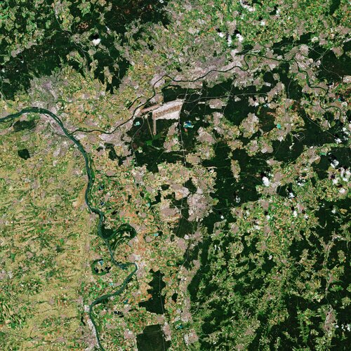 Image:
The Copernicus Sentinel-2 mission takes us over Darmstadt – home to ESA’s European Space Operations Centre.
Image:
The Copernicus Sentinel-2 mission takes us over Darmstadt – home to ESA’s European Space Operations Centre.
Earth from Space: Darmstadt
13.11.2020 10:00 ESA Observing the Earth Video:
00:03:56
Video:
00:03:56
In this week's edition of the Earth from Space programme, the Copernicus Sentinel-2 mission takes us over Darmstadt, Germany, home to ESA’s European Space Operations Centre,
See also Darmstadt, Germany to download the image.
Nové mapy s příběhem v novém
13.11.2020 9:12 blog ARCDATA Od července 2019, kdy Esri vydala novou generaci map s příběhem, která postupně nahrazuje klasické mapy s příběhem, již uplynul více než rok a za tu dobu se dočkaly mnoha změn a vylepšení. Co mapy s příběhem aktuálně nabízejí?SEOSAT-Ingenio hoisted into launch tower
13.11.2020 9:05 ESA Observing the Earth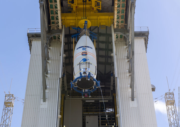
Ahead of its liftoff, scheduled on Tuesday 17 November 2020 at 02:52 CET (16 November 22:52 local time in Kourou), the SEOSAT-Ingenio satellite sealed in the rocket fairing has been hoisted into the Vega launch tower at Europe’s Spaceport in Kourou, French Guiana.
SEOSAT-Ingenio hoisted into launch tower
13.11.2020 9:05 ESA Observing the Earth
Ahead of its liftoff, scheduled for on Tuesday 17 November 2020 at 02:52 CET (16 November 22:52 local time in Kourou), the SEOSAT-Ingenio satellite sealed in the rocket fairing has been hoisted into the Vega launch tower at Europe’s Spaceport in Kourou, French Guiana.
RoadBotics Debuts Proprietary HD-PCI Pavement Rating Index
13.11.2020 9:00 GISCafe.com Webcasts-Webinars PITTSBURGH, PA, November 11, 2020 - RoadBotics is introducing a much-anticipated feature on its automated and objective road assessment …Eos Positioning Systems announces ability to consume Arrow GNSS location data in multiple Esri apps concurrently
13.11.2020 9:00 GISCafe.com Webcasts-Webinars NOVEMBER 2020, MONTREAL, CANADA — Eos Positioning Systems (Eos), the Canadian manufacturer of the leading high-accuracy Arrow …Scottish Government extends viaEuropa web services agreement
13.11.2020 9:00 GISCafe.com Webcasts-Webinars Europa Technologies is pleased to announce that the Scottish Government has extended its agreement for the use of viaEuropa web services for an …Bylo vydáno nové sestavení GEU
13.11.2020 8:47 GEUSwareBylo vydáno nové sestavení GEUS 24.0.6.279, ve kterém byl upraven vzorec pro "výběrovou střední chybu" (Sxy). Všem uživatelům doporučujeme toto sestavení nainstalovat.
GaKO 11/2020
13.11.2020 7:54 GaKO GaKO 11/2020 KUBÍČEK, P.–SNOPKOVÁ, D.–STACHOŇ, Z.–UHLÍK, O.–JUŘÍK, V.–UGWITZ, P.–ŠAŠINKA, Č.–OKŘINOVÁ, P.–APELTAUER, J.–APELTAUER, T.: Využití prostorové syntaxe pro formalizaci pohybu osob CHUDÁ, J.: Ručné mobilné laserové skenovanie a technológia SLAM v lesnom prostredí – posúdenie polohovej presnosti objektov a využiteľnosti technológieBentley Systems Announces Pricing of Public Offering of Common Stock
13.11.2020 2:17 Bentley Systems EXTON, Pa., U.S.A. – November 12, 2020 – Bentley Systems, Incorporated (Nasdaq: BSY) (“Bentley”), the infrastructure engineering software company, today announced the pricing of the public offering of 10,000,000 shares of its Class B common stock, consisting of 8,103,965 shares to be issued and sold by Bentley and 1,896,035 shares to be sold by existing stockholders of Bentley, at a price to the public of $32.00 per share. Bentley granted the underwriters in the offering a 30-day option to purchase from Bentley up to an additional 1,500,000 shares of Class B common stock. The offering is expected to close on November 17, 2020, subject to customary closing conditions.Bentley intends to use the net proceeds from the sale of its shares in the offering to repay existing indebtedness under its credit facilities. Bentley will not receive any proceeds from the sale of shares by the selling stockholders.
Goldman Sachs & Co. LLC and BofA Securities are acting as lead book-running managers and RBC Capital Markets, Baird and KeyBanc Capital Markets are also acting as joint book-running managers for the offering. Mizuho Securities is acting as a co-manager for the offering.
A registration statement on Form S-1 relating to the offering has been filed with, and declared effective by, the SEC. Copies of the registration statement can be accessed through the SEC’s website at www.sec.gov. This press release does not constitute an offer to sell or the solicitation of an offer to buy any securities, and shall not constitute an offer, solicitation, or sale in any jurisdiction in which such offer, solicitation, or sale would be unlawful prior to registration or qualification under the securities laws of that jurisdiction. Any offers, solicitations or offers to buy, or any sales of securities will be made in accordance with the registration requirements of the Securities Act of 1933, as amended.
The offering is being made only by means of a prospectus. Copies of the prospectus related to the offering, when available, may be obtained by contacting Goldman Sachs & Co. LLC, Attention: Prospectus Department at 200 West Street, New York, New York 10282, by telephone at 1-866-471-2526 or by e-mail at prospectus-ny@ny.email.gs.com, or BofA Securities, Attn: Prospectus Department, NC1-004-03-43, 200 North College Street, 3rd floor, Charlotte, North Carolina 28255-0001, by email at dg.prospectus_requests@bofa.com.
About Bentley Systems
Bentley Systems is the infrastructure engineering software company. We provide innovative software to advance the world’s infrastructure – sustaining both the global economy and environment. Our industry-leading software solutions are used by professionals, and organizations of every size, for the design, construction, and operations of roads and bridges, rail and transit, water and wastewater, public works and utilities, buildings and campuses, and industrial facilities. Our offerings include MicroStation-based applications for modeling and simulation, ProjectWise for project delivery, AssetWise for asset and network performance, and the iTwin platform for infrastructure digital twins. Bentley Systems employs more than 4,000 colleagues and generates annual revenues of more than $700 million, in 172 countries.
Forward Looking Statements
This press release contains forward-looking statements. Forward-looking statements include all statements that are not historical facts. The words “believe,” “may,” “will,” “estimate,” “continue,” “anticipate,” “intend,” “expect” and similar expressions are intended to identify forward-looking statements. These forward-looking statements include statements relating to, among other things, risks and uncertainties related to market conditions, the risk that the public offering will not be consummated on the terms or in the amounts contemplated or otherwise, and the satisfaction of customary closing conditions related to the public offering. These forward-looking statements are subject to a number of risks, uncertainties and assumptions, including those described under the “Risk Factors” section of Bentley’s registration statement relating to the offering. Except as required by law, Bentley has no obligation to update any of these forward-looking statements to conform these statements to actual results or revised expectations.
Konference “See the Future” – 17. a 18. listopadu 2020 [Knihovna geografie, byTopic]
13.11.2020 0:00 Katedra aplikované geoinformatiky a kartografie Přf UK Ve dnech 17. a 18. listopadu se koná online konference “See the Future“ společnosti Enago na téma „Budoucnost výzkumu a vysokoškolského vzdělávání.“Mezi vystupujícími uvidíte např. laureáta Nobelovy ceny za medicínu (hlavní projev) nebo osobnosti z top managementu největších světových vydavatelství v oboru STM (Elsevier, Wiley, American Chemical Society) včetně předního vydavatele open access titulů (Hindawi).
GAF AG and BKG intensify their cooperation regarding the provision of multi-source remote sensing data
12.11.2020 23:26 GISCafe.com Webcasts-Webinars ( München, 11.11.20 ) GAF AG, one of the largest European providers of geographic information services with a focus on earth observation, has …Targa Telematics Awards TomTom Multiyear Contract
12.11.2020 16:50 GISCafe.com Webcasts-Webinars AMSTERDAM, The Netherlands, Nov. 12, 2020 (GLOBE NEWSWIRE) -- TomTom (TOM2), the location technology specialist, and Targa Telematics, an …Illinois Institute of Technology to Establish Trimble Technology Lab for Civil, Architectural, and Environmental Engineering
12.11.2020 16:50 GISCafe.com Webcasts-Webinars SUNNYVALE, Calif., and CHICAGO, Nov. 12, 2020 — (PRNewswire) — Illinois Institute of Technology has received a gift from Trimble …Re:Earth, a web service that allows anyone to publish their archives digitally, has been launched!
12.11.2020 16:49 GISCafe.com Webcasts-Webinars TOKYO, JAPAN, Nov. 12, 2020 (GLOBE NEWSWIRE) -- Re:Earth supports a wide variety of visualization techniques and digital archiving for companies, …TravelTime Hosts ArcGIS Network Analysis Workshop For GIS Day
12.11.2020 16:47 GISCafe.com Webcasts-Webinars The TravelTime workshop on 18 November will help ArcGIS users make better business decisions with public transport data London, UK, November …
Kongsberg Geospatial and Unifly partner to provide integrated Urban Situational Awareness for drones
12.11.2020 16:46 GISCafe.com Webcasts-Webinars Kongsberg Geospatial and Unifly enable real-time drone monitoring in urban airspaces over LTE wireless broadband networksOTTAWA, Ontario, Nov. 12, …
Proběhl první seminář (METADATA) v rámci Dne s INSPIRE
12.11.2020 15:09 CENIA - národní geoportál INSPIRE Dne 10. 11. 2020 proběhl první seminář v rámci Dne s INSPIRE organizovaný CENIA, českou informační agenturou životního prostředí. Tento seminář se zaměřil na METADATA. Jednotlivé prezentace, včetně videozáznamů, si můžete prohlédnout zde. Děkujeme Všem účastníkům za zájem a připomínáme, že máte stále možnost se registrovat na další dva připravované termíny: TERMÍN 18. 11. 2020 (10:00–12:00) –...Nové návody na Národním geoportálu INSPIRE
12.11.2020 14:53 CENIA - národní geoportál INSPIRE Na Národním geoportálu INSPIRE v sekci (INSPIRE – Legislativa EU) byly přidány nové šedé rozklikávací záložky s metadatovým profilem ČR, návodem k novému metadatovému editoru a návody na harmonizaci dat pomocí programu Hale studio.Sentinel data enables new system for agricultural monitoring in Poland
12.11.2020 14:00 ESA Observing the Earth
Data from the Copernicus Sentinel satellites are enabling the national monitoring of agricultural activity in Poland – a colossal task that will support the efforts of key national agencies to assess a country’s cropland, productivity, and food security, as well as the implementation of the EU Common Agricultural Policy in years to come.
Coastal observations boosted by new reference satellite
12.11.2020 10:15 ESA Observing the Earth
As global temperatures continue to rise, coastal areas will increasingly bear the brunt of storm surges and more frequent, intense weather events. Sea level is rising at 3.6 centimetres per decade and this trend is accelerating, compounding the threats faced by coastal communities: with every centimetre another three million people are put at risk of annual coastal flooding. Scheduled to be launched on 21 November, the Copernicus Sentinel-6 Michael Freilich satellite is set to continue the long-term record of sea-level measurements that are needed for protect our coasts.
Už víte co koupit geografického pod stromeček?
12.11.2020 9:19 GISportal.cz
Za 42! dní, tedy přesně za 6 týdnů, jsou tu Vánoce 🙂 Pokud přemýšlíte, co byste mohli pořídit milovníkovi/vnici map, tak se můžete inspirovat např. v produktech nové české firmy Mapisimo, která si klade za cíl přiblížit krásu klasických map jejich netradičním zpracováním. Mapisimo je přidružený projekt redaktorů z české firmy Kartografie Praha. Nápad vytvořit Mapisimo se […]
The post Už víte co koupit geografického pod stromeček? appeared first on GISportal.cz.
SESAR publikoval nový report k U-Space
12.11.2020 8:47 UAVASESAR publikoval nový report k U-Space a postupu výzkumných projektů a inovací. Více informací a stažení je možné zde: https://www.sesarju.eu/node/3691
The post SESAR publikoval nový report k U-Space appeared first on UAV Aliance pro bezpilotní letecký průmysl.
NV5 Announces Record Third Quarter Results; Exceeds Analysts' Expectations
12.11.2020 3:15 GISCafe.com Webcasts-Webinars HOLLYWOOD, Fla., Nov. 11, 2020 (GLOBE NEWSWIRE) -- NV5 Global, Inc. (Nasdaq: NVEE) ("NV5" or the "Company"), a leading provider of compliance, …Bentley Systems Announces Pricing of Public Offering of Common Stock
12.11.2020 2:17 Bentley Systems EXTON, Pa., U.S.A. – November 12, 2020 – Bentley Systems, Incorporated (Nasdaq: BSY) (“Bentley”), the infrastructure engineering software company, today announced the pricing of the public offering of 10,000,000 shares of its Class B common stock, consisting of 8,103,965 shares to be issued and sold by Bentley and 1,896,035 shares to be sold by existing stockholders of Bentley, at a price to the public of $32.00 per share. Bentley granted the underwriters in the offering a 30-day option to purchase from Bentley up to an additional 1,500,000 shares of Class B common stock. The offering is expected to close on November 17, 2020, subject to customary closing conditions.Bentley intends to use the net proceeds from the sale of its shares in the offering to repay existing indebtedness under its credit facilities. Bentley will not receive any proceeds from the sale of shares by the selling stockholders.
Goldman Sachs & Co. LLC and BofA Securities are acting as lead book-running managers and RBC Capital Markets, Baird and KeyBanc Capital Markets are also acting as joint book-running managers for the offering. Mizuho Securities is acting as a co-manager for the offering.
A registration statement on Form S-1 relating to the offering has been filed with, and declared effective by, the SEC. Copies of the registration statement can be accessed through the SEC’s website at www.sec.gov. This press release does not constitute an offer to sell or the solicitation of an offer to buy any securities, and shall not constitute an offer, solicitation, or sale in any jurisdiction in which such offer, solicitation, or sale would be unlawful prior to registration or qualification under the securities laws of that jurisdiction. Any offers, solicitations or offers to buy, or any sales of securities will be made in accordance with the registration requirements of the Securities Act of 1933, as amended.
The offering is being made only by means of a prospectus. Copies of the prospectus related to the offering, when available, may be obtained by contacting Goldman Sachs & Co. LLC, Attention: Prospectus Department at 200 West Street, New York, New York 10282, by telephone at 1-866-471-2526 or by e-mail at prospectus-ny@ny.email.gs.com, or BofA Securities, Attn: Prospectus Department, NC1-004-03-43, 200 North College Street, 3rd floor, Charlotte, North Carolina 28255-0001, by email at dg.prospectus_requests@bofa.com.
About Bentley Systems
Bentley Systems is the infrastructure engineering software company. We provide innovative software to advance the world’s infrastructure – sustaining both the global economy and environment. Our industry-leading software solutions are used by professionals, and organizations of every size, for the design, construction, and operations of roads and bridges, rail and transit, water and wastewater, public works and utilities, buildings and campuses, and industrial facilities. Our offerings include MicroStation-based applications for modeling and simulation, ProjectWise for project delivery, AssetWise for asset and network performance, and the iTwin platform for infrastructure digital twins. Bentley Systems employs more than 4,000 colleagues and generates annual revenues of more than $700 million, in 172 countries.
Forward Looking Statements
This press release contains forward-looking statements. Forward-looking statements include all statements that are not historical facts. The words “believe,” “may,” “will,” “estimate,” “continue,” “anticipate,” “intend,” “expect” and similar expressions are intended to identify forward-looking statements. These forward-looking statements include statements relating to, among other things, risks and uncertainties related to market conditions, the risk that the public offering will not be consummated on the terms or in the amounts contemplated or otherwise, and the satisfaction of customary closing conditions related to the public offering. These forward-looking statements are subject to a number of risks, uncertainties and assumptions, including those described under the “Risk Factors” section of Bentley’s registration statement relating to the offering. Except as required by law, Bentley has no obligation to update any of these forward-looking statements to conform these statements to actual results or revised expectations.
Nová funkční rozšíření pro Fusion 360
12.11.2020 1:00 CAD Studio Autodesk upravil a rozšířil svou nabídku funkčních rozšíření (extensions) pro Fusion 360, které vám díky speciální certifikaci CAD Studia můžeme nabídnout. Na první pohled by se mohlo zdát zbytečné doplňovat jakákoli rozšíření, protože Autodesk Fusion ...
Zhlédněte ve dnech 16. až 22.1
12.11.2020 0:00 SolidVision Zhlédněte ve dnech 16. až 22.11. devět video prezentací novinek SOLIDWORKS 2021Knihovna geografie ve dnech 16. a 17.11.2020 [Knihovna geografie, byTopic]
12.11.2020 0:00 Katedra aplikované geoinformatiky a kartografie Přf UK Ve dnech 16. listopadu (na základě rozhodnutí rektorátu UK) a 17. listopadu 2020 (státní svátek ČR) je knihovna zcela uzavřena a neposkytuje své služby ani v omezeném režimu (příprava výpůjček apod.).Zhlédněte ve dnech 16. až 22.1
12.11.2020 0:00 SolidVision Zhlédněte ve dnech 16. až 22.11. devět video prezentací novinek SOLIDWORKS 2021Výzva k podání návrhu - Horní Benešov
12.11.2020 0:00 Státní pozemkový úřad SPÚ vyhlašuje výzvu k podání návrhů na uzavření nájemní smlouvy - Horní BenešovExplore AEC Industry Trends with Microsol Resources at Autodesk University 2020
11.11.2020 23:50 GISCafe.com Webcasts-Webinars NEW YORK, Nov. 11, 2020 — (PRNewswire) — Microsol Resources is exhibiting at Autodesk University (AU) 2020 on November 17-20. …Satellogic successfully launches 10 new satellites expanding European Space Imaging’s satellite access portfolio
11.11.2020 23:26 GISCafe.com Webcasts-Webinars On Friday 6 November, Satellogic, the first company to develop a scalable Earth observation platform with the ability to remap the entire planet at …ISPRS e-Bulletin Issue No 4 – 2020
11.11.2020 22:33 Společnost pro fotogrammetrii a dálkový průzkumISPRS e-bulletin: 2020 – Issue No.1 </obj
The post ISPRS e-Bulletin Issue No 4 – 2020 appeared first on SFDP.
Autonomous Drone Maker Skydio Appoints New VP of Channel and Alliances Adds New Sales Executives to The Federal Sales Team
11.11.2020 15:41 GISCafe.com Webcasts-Webinars Skydio appoints Industry and Military Veterans Trent Hall as VP of Channel & Alliances, and Federal Sales team additions Sai Williams and Ron …Copernicus Sentinel-6 ready for launch
11.11.2020 14:00 ESA Observing the Earth Video:
00:03:00
Video:
00:03:00
Final preparations are underway in California for the launch of Sentinel-6 Michael Freilich, a joint European and US satellite designed to take precise measurements of sea-level change. The satellite forms part of the European Union’s Copernicus Earth Observation programme and will employ a radar altimeter to map sea-surface topography. The satellite will provide fundamental data for climate science and policymaking, helping to protect the 600 million people who live in vulnerable coastal areas. It will also deliver near-realtime information for marine and weather forecasts.
The mission is a collaboration between ESA, the European Commission, EUMETSAT, NASA and NOAA, with support from the French space agency CNES. Scheduled for launch on 21 November on a SpaceX Falcon 9 rocket from the Vandenberg Air Force Base on the California coast, the satellite is named Michael Freilich after NASA’s former Director of Earth Science.
A-roll contains clean room images from Vandenberg and new interviews. B-roll includes clean room, nearby coast and soundbites in English, French and German.
20201111 Rada / odborný rada oddělení aktualizace KN
11.11.2020 13:35 ČÚZK /Urady/Katastralni-urady/Katastralni-urady/Katastralni-urad-pro-Stredocesky-kraj/Katastralni-pracoviste/KP-Kolin/O-uradu/Aktuality/20190828-Odborny-rada-oddeleni-pravnich-vztahu-(1)20201111 Rada / odborný rada oddělení aktualizace KN
11.11.2020 13:35 ČÚZK - předpisy a opatření Katastrální úřad pro Středočeský kraj - Katastrální pracoviště Kolín Vyhlášení výběrového řízení: Rada / odborný rada oddělení aktualizace KN V části "Úřední deska", v sekci "Oznámení a jiná úřední sdělení" bylo vystaveno "Oznámení o vyhlášení výběrového řízení na obsazení služebního místa Rada / odborný rada oddělení aktualizace KN "Rada / odborný rada oddělení aktualizace KN
11.11.2020 13:34 ČÚZK /Urady/Katastralni-urady/Katastralni-urady/Katastralni-urad-pro-Stredocesky-kraj/Uredni-deska/Oznameni-a-jina-uredni-sdeleni/Volna-mista/Rada-odborny-rada-oddeleni-aktualizace-KNRada / odborný rada oddělení aktualizace KN
11.11.2020 13:34 ČÚZK - předpisy a opatření Katastrální úřad pro Středočeský kraj - Katastrální pracoviště Kolínvypisuje výběrové řízení na místo Rada / odborný rada oddělení aktualizace KN
Rada / odborný rada oddělení aktualizace KN
Rada / odborný rada oddělení aktualizace KN
11.11.2020 13:34 ČÚZK - volná místa Katastrální úřad pro Středočeský kraj - Katastrální pracoviště Kolín vypisuje výběrové řízení na místo Rada / odborný rada oddělení aktualizace KNAlstom pioneers the use of Galileo to help measure the location and speed of trains
11.11.2020 12:25 European GNSS Agency
In June 2020, Alstom became the first railway manufacturer to integrate certified data fusion algorithms for fail-safe train localization, using position and speed of trains based on GNSS data coming from multiple constellations including Galileo, the European Union navigation satellite system.
The added-value of Galileo and EGNOS, the European Union Global Navigation Satellite System (EGNSS) in the European railway sector is widely known, especially when it comes to non-safety applications, such asset management and passenger information services. In recent years, however, with multi-constellation becoming the norm and multifrequency receivers being adopted rapidly, rail stakeholders view GNSS-based solutions as game-changers for the future of European Train Control System (ETCS).
A recent example of E-GNSS adoption in rail operations is the innovative odometry solution deployed by Alstom to measure the location and speed of its trains. The French rolling stock manufacturer introduced a new sensor type, with a hybridisation of satellite information and inertial sensors. The solution is primarily using GNSS Doppler information, derived from Galileo, GPS and GLONASS constellations (configurable). Such use allows to improve the overall confidence in the resulting speed, along with specific algorithms to master the resulting location accuracy. The GNSS receiver is an automotive grade receiver manufactured by u-blox. The Inertial Measurement Unit (IMU) used to supplement information in case of GNSS loss is based on enhanced micro-electromechanical systems (MEMS) technology, with temperature compensation. The new odometry system based on data fusion, which Alstom is currently implementing in Norway, is applicable to all types of trains and all environments, including the harshest weather conditions. It is estimated that by 2026, 450 trains will be equipped with this new feature across Norway.
Increased Safety, Lower Costs for rail companies
Wheel slipping and sliding especially during demanding weather conditions can affect the odometer accuracy and the proper functioning of the different sensors involved. By incorporating Galileo signals as an extra layer of accuracy, Alstom managed to create a system that is capable of providing a more robust speed and location estimate. This space data fusion approach -certified by Belgorail- minimizes the need for the costly external radar components for localisation and speed measurement currently used.
“Industry embedding Galileo in their solutions is the proof that we are on the right path to ensure the market uptake of the EU Space Programme technology. This is a recognition of the capability of EGNSS to reduce the need for infrastructure and related cost, while maintaining the operational safety of ETCS.” Declared Rodrigo da Costa, GSA Executive Director.
Media note: This feature can be republished without charge provided the European GNSS Agency (GSA) is acknowledged as the source at the top or the bottom of the story. You must request permission before you use any of the photographs on the site. If you republish, we would be grateful if you could link back to the GSA website (http://www.gsa.europa.eu).
Alstom pioneers the use of Galileo to help measure the location and speed of trains
11.11.2020 12:25 European GNSS AgencyIn June 2020, Alstom became the first railway manufacturer to integrate certified data fusion algorithms for fail-safe train localization, using position and speed of trains based on GNSS data coming from multiple constellations notably Galileo, the European Union navigation satellite system.
The added-value of Galileo and EGNOS, the European Union Global Navigation Satellite System (EGNSS) in the European railway sector when it comes to non-safety applications, such asset management and passenger information services is widely known. In recent years, however, with multi-constellation being the norm and multifrequency receivers being adopted rapidly, rail stakeholders view GNSS-based solutions as game changers for the future of European Train Control System (ETCS).
A recent example of E-GNSS adoption in rail operations is the innovative odometry solution deployed by Alstom to measure the location and speed of its trains. The French rail product manufacturer introduced a new sensor type, with a hybridisation of satellite information and inertial sensors (IMU). The solution is primarily using GNSS Doppler information, derived from Galileo, GPS and GLONASS constellations (configurable). Such use allows to improve the overall confidence in the resulting speed, along with specific algorithms to master the resulting location accuracy. The GNSS receiver is an automotive grade receiver manufactured by Ublox. The IMU used to supplement information in case of GNSS loss is based on enhanced MEMS technology, with temperature compensation. The new odometry system based on data fusion, which Alstom is currently implementing in Norway, is applicable to all types of trains and all environments, including the harshest weather conditions. It is estimated that by 2026, 450 trains will be equipped with this new feature across Norway.
Increased Safety, Lower Costs for rail companies
Wheel slipping and sliding especially during demanding weather conditions can affect the odometer accuracy and the proper functioning of the different sensors involved. By incorporating Galileo signals as an extra layer of accuracy, Alstom managed to create a system that is capable of providing a more robust speed and location estimate. This space data fusion approach -certified by Belgorail- minimizes the need for the costly external radar components for localisation and speed measurement that are used today.
“Industry embedding Galileo in their solutions is the proof that we are on the right path to ensure the market uptake of the EU Space Programme technology. This is a recognition of the capability of EGNSS to reduce the need for infrastructure and related cost, while maintaining the operational safety of ETCS.” Declared Rodrigo da Costa, GSA Executive Director.
Media note: This feature can be republished without charge provided the European GNSS Agency (GSA) is acknowledged as the source at the top or the bottom of the story. You must request permission before you use any of the photographs on the site. If you republish, we would be grateful if you could link back to the GSA website (http://www.gsa.europa.eu).
Výběrové řízení
11.11.2020 12:18 ČÚZK - předpisy a opatření Katastrální úřad pro Plzeňský kraj - Katastrální pracoviště Plzeň-sever zveřejnil novou aktualitu: Ředitelka Katastrálního úřadu pro Plzeňský kraj vyhlašuje výběrové řízení na služební místo rada/odborný rada – kontrola listin určených k záznamu – KL1101, oddělení právních vztahů k nemovitostem, Katastrální úřad pro Plzeňský kraj, Katastrální pracoviště Plzeň-sever.Oznámení o vyhlášení výběrového řízení na služební místo rada/odborný rada – kontrola listin určenýc
11.11.2020 12:13 ČÚZK /Urady/Katastralni-urady/Katastralni-urady/Katastralni-urad-pro-Plzensky-kraj/Uredni-deska/Oznameni-a-jina-uredni-sdeleni/Volna-mista/DMS/Oznameni-o-vyhlaseni-vyberoveho-rizeni-na-sluzebniOznámení o vyhlášení výběrového řízení na služební místo rada/odborný rada – kontrola listin určenýc
11.11.2020 12:13 ČÚZK - předpisy a opatření Katastrální úřad pro Plzeňský kraj Katastrální pracoviště Plzeň-severvypisuje výběrové řízení na místo
Oznámení o vyhlášení výběrového řízení na služební místo rada/odborný rada – kontrola listin určených k záznamu KL1101
Oznámení o vyhlášení výběrového řízení na služební místo rada/odborný rada – kontrola listin určenýc
11.11.2020 12:13 ČÚZK - volná místa Katastrální úřad pro Plzeňský kraj Katastrální pracoviště Plzeň-sever vypisuje výběrové řízení na místo Oznámení o vyhlášení výběrového řízení na služební místo rada/odborný rada – kontrola listin určenýc20201111 Odborný referent oddělení dokumentace KN
11.11.2020 12:00 ČÚZK /Urady/Katastralni-urady/Katastralni-urady/Katastralni-urad-pro-Stredocesky-kraj/Katastralni-pracoviste/KP-Praha-zapad/O-uradu/Aktuality/20190828-Odborny-rada-oddeleni-pravnich-vztahu-(4)20201111 Odborný referent oddělení dokumentace KN
11.11.2020 12:00 ČÚZK - předpisy a opatření Katastrální úřad pro Středočeský kraj - Katastrální pracoviště Praha-západ Vyhlášení výběrového řízení: Odborný referent oddělení dokumentace KN V části "Úřední deska", v sekci "Oznámení a jiná úřední sdělení" bylo vystaveno "Oznámení o vyhlášení výběrového řízení na obsazení služebního místa Odborný referent oddělení dokumentace KN "Odborný referent oddělení dokumentace KN
11.11.2020 11:53 ČÚZK /Urady/Katastralni-urady/Katastralni-urady/Katastralni-urad-pro-Stredocesky-kraj/Uredni-deska/Oznameni-a-jina-uredni-sdeleni/Volna-mista/Odborny-referent-oddeleni-dokumentace-KNOdborný referent oddělení dokumentace KN
11.11.2020 11:53 ČÚZK - volná místa Katastrální úřad pro Středočeský kraj - Katastrální pracoviště Praha-západ vypisuje výběrové řízení na místo Odborný referent oddělení dokumentace KNOdborný referent oddělení dokumentace KN
11.11.2020 11:53 ČÚZK - předpisy a opatření Katastrální úřad pro Středočeský kraj - Katastrální pracoviště Praha-západvypisuje výběrové řízení na místo Odborný referent oddělení dokumentace KN
Odborný referent oddělení dokumentace KN
Současné fungování knihovny [Knihovna geografie, byTopic]
11.11.2020 11:15 Katedra aplikované geoinformatiky a kartografie Přf UK Ačkoliv je Knihovna geografie od 21.10.2020 do odvolání pro veřejnost kvůli pandemické situaci uzavřena (přístup do studovny je zakázán, nelze používat počítače a tiskárny), půjčování a vracení dokumentů v omezeném režimu je stále možné! Zároveň kvůli prodloužení nouzového stavu do 12. prosince 2020 prodlužujeme našim čtenářům výpůjčky, které končí v intervalu 23.11.-1.12.2020, až do 4. ledna 2021!Současné fungování knihovny [Knihovna geografie, byTopic]
11.11.2020 11:15 Katedra aplikované geoinformatiky a kartografie Přf UK Ačkoliv je Knihovna geografie od 21.10.2020 do odvolání pro veřejnost kvůli pandemické situaci uzavřena (přístup do studovny je zakázán, nelze používat počítače a tiskárny), půjčování a vracení dokumentů v omezeném režimu (bezkontaktně) je stále možné! Zároveň kvůli prodloužení nouzového stavu prodlužujeme našim čtenářům výpůjčky až do 21. ledna 2021!Současné fungování knihovny [Knihovna geografie, byTopic]
11.11.2020 11:15 Katedra aplikované geoinformatiky a kartografie Přf UK Ačkoliv je Knihovna geografie od 21.10.2020 do odvolání pro veřejnost kvůli pandemické situaci uzavřena (přístup do studovny je zakázán, nelze používat počítače a tiskárny), půjčování a vracení dokumentů v omezeném režimu je stále možné! Zároveň kvůli prodloužení nouzového stavu prodlužujeme našim čtenářům výpůjčky až do 4. ledna 2021!Současné fungování knihovny [Knihovna geografie, byTopic]
11.11.2020 11:15 Katedra aplikované geoinformatiky a kartografie Přf UK Ačkoliv je Knihovna geografie od 21.10.2020 do odvolání pro veřejnost kvůli pandemické situaci uzavřena (přístup do studovny je zakázán, nelze používat počítače a tiskárny), půjčování a vracení dokumentů v omezeném režimu je stále možné!Současné fungování knihovny [Knihovna geografie, byTopic]
11.11.2020 11:15 Katedra aplikované geoinformatiky a kartografie Přf UK Ačkoliv je Knihovna geografie od 21.10.2020 do odvolání pro veřejnost kvůli pandemické situaci uzavřena (přístup do studovny je zakázán, nelze používat počítače a tiskárny), půjčování a vracení dokumentů v omezeném režimu (bezkontaktně) je stále možné! Zároveň kvůli prodloužení nouzového stavu prodlužujeme našim čtenářům výpůjčky až do 1. března 2021!Conference ENC 2020
11.11.2020 11:07 Satlab GeosolutionsEuropean Navigation Conference (ENC 2020) Event: European Navigation Conference (ENC 2020) Date: 23 – 24 November 2020, ONLINE Organizer : Deutsche Gesellschaft für Ortung und Navigation (DGON) -German Institute of Navigation The European Navigation Conference (ENC) is the scientific conference on navigation in Europe, which is organized by the German Institute of Navigation(DGON). It will take […]
The post Conference ENC 2020 appeared first on SatLab – Global Satellite Positioning Solutions.
ENC Conference 2020
11.11.2020 11:07 Satlab GeosolutionsEuropean Navigation Conference (ENC 2020) Event: Europe […]
The post ENC Conference 2020 appeared first on SatLab – Global Satellite Positioning Solutions.
ENC Conference 2020
11.11.2020 11:07 Satlab GeosolutionsEuropean Navigation Conference (ENC 2020) Event: European Navigation Conference (ENC 2020) Date: 23 – 24 November 2020, ONLINE Organizer : Deutsche Gesellschaft für Ortung und Navigation (DGON) -German Institute of Navigation The European Navigation Conference (ENC) is the scientific conference on navigation in Europe, which is organized by the German Institute of Navigation(DGON). It will take […]
The post ENC Conference 2020 appeared first on SatLab – Global Satellite Positioning Solutions.
Tvorba vlastního widgetu do ArcGIS Experience Builder (workshop)
11.11.2020 8:55 GISportal.czV rámci letošní virtuální Konference GIS Esri v ČR proběhne online také několik workshopů. Druhý se bude konat ve čtvrtek 12. listopadu v čase 10.00 – 11.00. Workshopem Vás provede Jan Šarata ze společnosti ARCDATA PRAHA, s.r.o. Abstrakt workshopu: ArcGIS Experience Builder se neustále rozvíjí a funkcionalita, kterou disponuje, stále roste. Někdy ale přece jen […]
The post Tvorba vlastního widgetu do ArcGIS Experience Builder (workshop) appeared first on GISportal.cz.