


![]()

zprávy
zdroje zpráv:SEOSAT-Ingenio sealed from view
10.11.2020 10:30 ESA Observing the Earth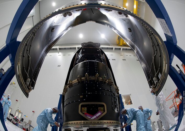
As preparations for the launch of SEOSAT-Ingenio continue on schedule, the team at Europe’s spaceport in Kourou have bid farewell to the satellite as it was sealed inside the rocket fairing over the weekend. The spacecraft is currently scheduled to launch on the evening of Monday 16 November/morning of Tuesday 17 November.
SEOSAT-Ingenio sealed from view
10.11.2020 10:30 ESA Observing the Earth
As preparations for the launch of SEOSAT-Ingenio continue on schedule, the team at Europe’s spaceport in Kourou have bid farewell to the satellite as it was sealed inside the rocket fairing. The spacecraft is currently scheduled to launch on the evening of Monday 16 November/morning of Tuesday 17 November.
Dotazník k INSPIRE
10.11.2020 9:04 GISportal.czVážené kolegyně, vážení kolegové, CENIA si Vás dovoluje požádat o vyplnění dotazníku, zacíleného na budoucí vývoj INSPIRE. Průzkum se zaměřuje na širokou škálu aspektů, které umožňují vyhodnotit INSPIRE na evropské úrovni, příkladem mohou být předpisy EU (na data, technologie a standardy) nebo interakce mezi INSPIRE stakeholdery (např. mezi členskými státy a institucemi EU). Dotazník naleznete […]
The post Dotazník k INSPIRE appeared first on GISportal.cz.
Změny programu Autodesk Subscription a Maintenance (licence na jméno, datum)
10.11.2020 1:00 CAD Studio Autodesk oznámil plán utlumení a ukončení licencí založených na sériovém číslu (včetně síťových) a přechod na licence pro konkrétní uživatele. Tím umožní snazší spolupráci, cílené výukové nástroje, lepší přehled o využití licencí a pohodlnější použití ...Nabídka práce - GIS analytik
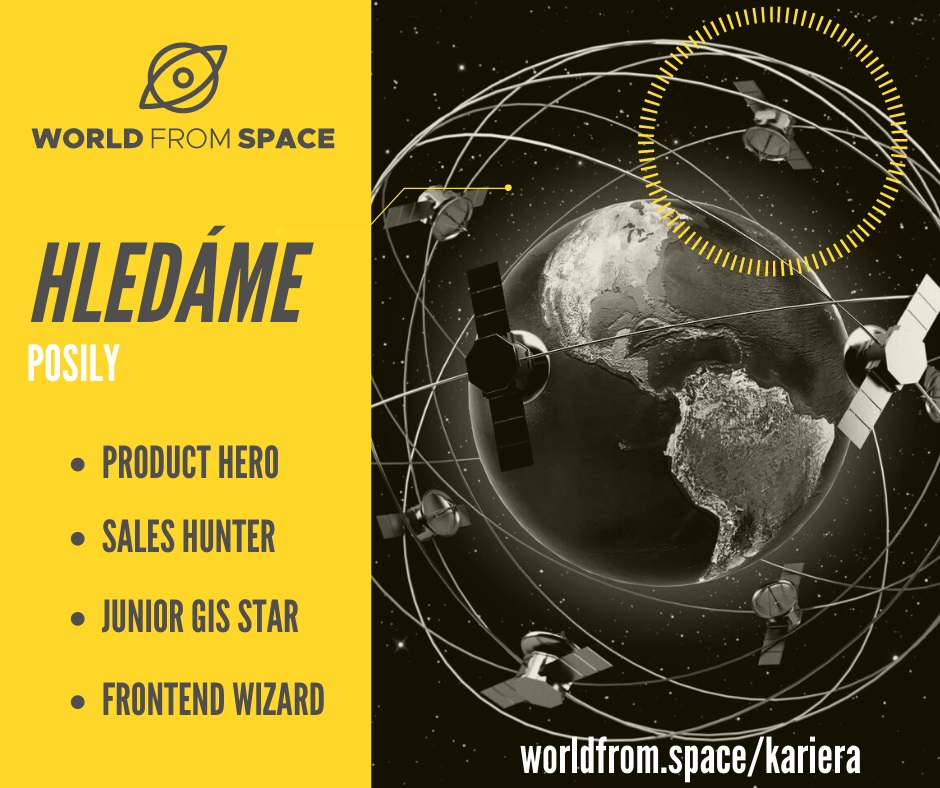
10.11.2020 0:00 Geografický ústav MUAerokosmická společnost World from Space hledá posily do svého týmu na pozici GIS analytika.
Bližší informace: https://worldfrom.space/en/satellite-gis-junior-analyst/
Facebook: https://www.facebook.com/worldfromspace/photos/a.2002819516628249/2771083029801890
Location Intelligence Platform Local Logic Raises $8 Million in Series A Funding to Accelerate Expansion
9.11.2020 17:57 GISCafe.com Webcasts-Webinars Investment will fuel new partnerships to help homebuyers and real estate professionals reimagine the way cities are planned, built, and …Successful launch of Kleos Space Satellites
9.11.2020 17:00 GISCafe.com Webcasts-Webinars Successful launch of Kleos Space Scouting Mission satellites into 37 degree Inclined OrbitKleos’ cluster of four satellites (KSM1) deployed …
Red Cat Completes Fat Shark Acquisition, Expanding Presence in FPV Drone Market
9.11.2020 16:59 GISCafe.com Webcasts-Webinars ORLANDO, Fla., Nov. 9, 2020 — (PRNewswire) — Red Cat Holdings, Inc. (OTC: RCAT) ("Red Cat" or the "Company"), a leading brand in the …Workhorse Group Reports Third Quarter 2020 Results
9.11.2020 16:59 GISCafe.com Webcasts-Webinars CINCINNATI, Nov. 9, 2020 — (PRNewswire) — Workhorse Group Inc. (Nasdaq: WKHS) ("Workhorse" or "the Company"), an American …Esri Announces Launch of ArcGIS Field Maps
9.11.2020 16:58 GISCafe.com Webcasts-Webinars Cutting-Edge App Delivers Multi-Functional Capabilities to Support Field WorkflowsREDLANDS, Calif. — (BUSINESS WIRE) — November 9, 2020 …
New Light Technologies and NoBrainerData Partner to Strengthen Demography Data-Driven innovations
9.11.2020 16:58 GISCafe.com Webcasts-Webinars WASHINGTON, Nov. 9, 2020 — (PRNewswire) — New Light Technologies Inc. (NLT) is partnering with NoBrainerData to develop and …DAEX CUT Optimalizátor 21
9.11.2020 15:54 ŠPINAR - software Vážení zákazníci, dovolujeme si Vám nabídnout program pro truhláře a výrobce nábytku. Na našem trh jsme uvolnili novou verzi programu DAEX CUT Optimalizátor 21 pro správu zakázek a optimalizaci nářezových plánů. DAEX CUT Optimalizátor nabízíme ve verzích Professional a Basic. Chcete zvýšit kvalitu Vašich výstupů a uspořit čas při navrhování? Program DAEX CUT Optimalizátor Vám to umožní! Program DAEX CUT Optimalizátor nabízí: Optimální...Read moreDAEX CUT Optimalizátor 21
9.11.2020 15:54 ŠPINAR - softwareVážení zákazníci, dovolujeme si Vám nabídnout program pro truhláře a výrobce nábytku. Na našem trh jsme uvolnili novou verzi programu DAEX CUT Optimalizátor 21 pro správu zakázek a optimalizaci nářezových plánů. DAEX CUT Optimalizátor nabízíme ve verzích Professional a Basic. Chcete zvýšit kvalitu Vašich výstupů a uspořit čas při navrhování? Program DAEX CUT Optimalizátor Vám to umožní! Program DAEX CUT Optimalizátor nabízí: Optimální...Read more
The post DAEX CUT Optimalizátor 21 appeared first on ŠPINAR – software.
20201109 Odborný referent oddělení právních vztahů k nemovitostem
9.11.2020 13:45 ČÚZK /Urady/Katastralni-urady/Katastralni-urady/Katastralni-urad-pro-Stredocesky-kraj/Katastralni-pracoviste/KP-Mlada-Boleslav/O-uradu/Aktuality/20190828-Odborny-rada-oddeleni-pravnich-vztahu-(3)20201109 Odborný referent oddělení právních vztahů k nemovitostem
9.11.2020 13:45 ČÚZK - předpisy a opatření Katastrální úřad pro Středočeský kraj - Katastrální pracoviště Mladá Boleslav Vyhlášení výběrového řízení: Odborný referent oddělení právních vztahů k nemovitostem V části "Úřední deska", v sekci "Oznámení a jiná úřední sdělení" bylo vystaveno "Oznámení o vyhlášení výběrového řízení na obsazení služebního místa Odborný referent oddělení právních vztahů k nemovitostem "Odborný referent oddělení právních vztahů k nemovitostem
9.11.2020 13:43 ČÚZK - předpisy a opatření Katastrální úřad pro Středočeský kraj - Katastrální pracoviště Mladá Boleslavvypisuje výběrové řízení na místo Odborný referent oddělení právních vztahů k nemovitostem
Odborný referent oddělení právních vztahů k nemovitostem
Odborný referent oddělení právních vztahů k nemovitostem
9.11.2020 13:43 ČÚZK - volná místa Katastrální úřad pro Středočeský kraj - Katastrální pracoviště Mladá Boleslav vypisuje výběrové řízení na místo Odborný referent oddělení právních vztahů k nemovitostem20201109 - Dokončení instalace nové verze ISKN 9.1
9.11.2020 12:20 ČÚZK - Výměnný formát ISKN Instalace ISKN 9.1 byla dokončena 7. 11. 2020. Od tohoto data jsou exporty VF ISKN vydávány ve verzi 5.5.20201109 - Dokončení instalace nové verze ISKN 9.1
9.11.2020 12:20 ČÚZK - Výměnný formát ISKN Instalace ISKN 9.1 byla dokončena 7. 11. 2020. Od tohoto data jsou exporty VF ISKN vydávány ve verzi 5.5.odborný referent – zápisy v řízení V a Z v oddělení právních vztahů k nemovitostem Katastrálního pra
9.11.2020 11:21 ČÚZK /Urady/Katastralni-urady/Katastralni-urady/Katastralni-urad-pro-Jihocesky-kraj/Uredni-deska/Oznameni-a-jina-uredni-sdeleni/Volna-mista/odborny-referent-–-zapisy-v-rizeni-V-a-Z-v-oddelenodborný referent – zápisy v řízení V a Z v oddělení právních vztahů k nemovitostem Katastrálního pra
9.11.2020 11:21 ČÚZK - předpisy a opatření Katastrální úřad pro Jihočeský kraj - Katastrální pracoviště Český Krumlovvypisuje výběrové řízení na místo
odborný referent – zápisy v řízení V a Z v oddělení právních vztahů k nemovitostem Katastrálního pracoviště Český Krumlov
odborný referent – zápisy v řízení V a Z v oddělení právních vztahů k nemovitostem Katastrálního pra
9.11.2020 11:21 ČÚZK - volná místa Katastrální úřad pro Jihočeský kraj - Katastrální pracoviště Český Krumlov vypisuje výběrové řízení na místo odborný referent – zápisy v řízení V a Z v oddělení právních vztahů k nemovitostem Katastrálního praKonference GIS Esri v ČR očima organizátorů (TZ)
9.11.2020 9:15 GISportal.cz
Konference GIS Esri v ČR se letos pořádal již 29. ročník, virtuální formu jsme si však vyzkoušeli úplně poprvé. Velmi si proto ceníme toho, že účast na konferenci byla dokonce vyšší než v předchozích, tradičně pořádaných ročnících – tuto konferenci navštívilo 1152 účastníků z 366 organizací. Hlavní blok přednášek – digitální transformace a GIS Na Konferenci GIS […]
The post Konference GIS Esri v ČR očima organizátorů (TZ) appeared first on GISportal.cz.
Detecting pollution from individual ships from space
9.11.2020 9:15 ESA Observing the Earth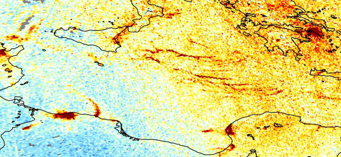
For the first time, scientists, using data from the Copernicus Sentinel-5P satellite, are now able to detect nitrogen dioxide plumes from individual ships from space.
ArcGIS Pro – tipy a triky (workshop)
9.11.2020 8:47 GISportal.cz
V rámci letošní virtuální Konference GIS Esri v ČR proběhne online také několik workshopů. První se bude konat v úterý 10. listopadu v čase 10.00 – 11.00. Workshopem Vás provede Petr Čejka ze společnosti ARCDATA PRAHA, s.r.o. Abstrakt workshopu: V rámci již tradičního workshopu zaměřujícího se zejména na desktopové technologie vás seznámíme se stávající i […]
The post ArcGIS Pro – tipy a triky (workshop) appeared first on GISportal.cz.
OGC simplifies EO data access and analysis through novel, standards-based technique
6.11.2020 21:16 GISCafe.com Webcasts-Webinars Fruitful collaboration between OGC Pilot Sponsors (NRCan and ESA) and Participants has supported the "application-to-the-data" principle by …Through Dedicated Launch Satellogic Expands In-orbit Capacity, Offering Customers Increased Revisit Capabilities and Access to Sub-Meter Imagery
6.11.2020 17:08 GISCafe.com Webcasts-Webinars With the addition of 10 new satellites, Satellogic’s fleet now provides up to four daily revisits of any point of interestBUENOS AIRES, Argentina …
Geodet/ka
6.11.2020 16:35 ČÚZK - volná místa Zeměměřický úřad vypisuje výběrové řízení na místo Geodet/kaGeodet/ka
6.11.2020 16:35 ČÚZK - předpisy a opatření Zeměměřický úřadvypisuje výběrové řízení na místo
Geodet/ka
Geodet/ka
6.11.2020 16:35 ČÚZK /Urady/Zememericky-urad/Uredni-deska/Oznameni-a-jina-uredni-sdeleni/Volna-mista/Geodet-ka-(1)Geodet/ka
6.11.2020 16:35 Zeměměřický úřad Zeměměřický úřadvypisuje výběrové řízení na místo
Geodet/ka
Kolega Michal Šprlák se podílel na jedinečném výzkumu hustoty kůry a gravitačního pole Měsíce
6.11.2020 15:58 Blogující geomatici - FAV ZČUZnámé údaje o nejbližším vesmírném sousedovi planety Země jsou opět o něco přesnější a zásluhu na tom má také vědec Michal Šprlák z katedry geomatiky Fakulty aplikovaných věd Západočeské univerzity v Plzni. On a jeho australští kolegové Shin-Chan Han a Will Featherstone totiž vyvinuli numerickou metodu, pomocí níž lze určit hustotu uvnitř planetárních těles na základě údajů nasbíraných družicemi. Metodu aplikovali právě na Měsíc, a získali tak velmi přesnou představu o hustotě jeho kůry. Údaje i vyvinutá metoda budou nyní sloužit dalším výzkumníkům, které o úspěchu informoval článek Crustal density and global gravitational field estimation of the Moon from GRAIL and LOLA satellite data (Odhad hustoty kůry a globálního gravitačního pole Měsíce z dat družicové mise GRAIL a senzoru LOLA) v mezinárodním vědeckém časopisu Planetary and Space Science.
Více informací na webu INFO ZČU zde: https://info.zcu.cz/clanek.jsp?id=3172
odborný referent – zápisy v řízení V a Z v odboru právních vztahů k nemovitostem Katastrálního praco
6.11.2020 13:25 ČÚZK /Urady/Katastralni-urady/Katastralni-urady/Katastralni-urad-pro-Jihocesky-kraj/Uredni-deska/Oznameni-a-jina-uredni-sdeleni/Volna-mista/odborny-referent-–-zapisy-v-rizeni-V-a-Z-v-odboruodborný referent – zápisy v řízení V a Z v odboru právních vztahů k nemovitostem Katastrálního praco
6.11.2020 13:25 ČÚZK - předpisy a opatření Katastrální úřad pro Jihočeský kraj - Katastrální pracoviště České Budějovicevypisuje výběrové řízení na místo
odborný referent – zápisy v řízení V a Z v odboru právních vztahů k nemovitostem Katastrálního pracoviště České Budějovice
odborný referent – zápisy v řízení V a Z v odboru právních vztahů k nemovitostem Katastrálního praco
6.11.2020 13:25 ČÚZK - volná místa Katastrální úřad pro Jihočeský kraj - Katastrální pracoviště České Budějovice vypisuje výběrové řízení na místo odborný referent – zápisy v řízení V a Z v odboru právních vztahů k nemovitostem Katastrálního pracoOdborný referent/vrchní referent v oddělení dokumentace Katastrálního pracoviště Rychnov n. K.
6.11.2020 11:53 ČÚZK /Urady/Katastralni-urady/Katastralni-urady/Katastralni-urad-pro-Kralovehradecky-kraj/Katastralni-pracoviste/KP-Rychnov-nad-Kneznou/O-uradu/Aktuality/Odborny-referent-vrchni-referent-v-oddeleni-dokumeOdborný referent/vrchní referent v oddělení dokumentace Katastrálního pracoviště Rychnov n. K.
6.11.2020 11:53 ČÚZK - předpisy a opatření Katastrální úřad pro Královéhradecký kraj - Katastrální pracoviště Rychnov nad Kněžnou zveřejnil novou aktualitu: Výběrové řízení na služební místo Odborný referent / vrchní referent v oddělení dokumentace Katastrálního pracoviště Rychnov nad KněžnouOdborný referent/vrchní referent v oddělení dokumentace Katastrálního pracoviště Rychnov n. K.
6.11.2020 11:53 ČÚZK - předpisy a opatření Český úřad zeměměřický a katastrální zveřejnil novou aktualitu: Výběrové řízení na služební místo Odborný referent / vrchní referent v oddělení dokumentace Katastrálního pracoviště Rychnov nad KněžnouOdborný referent / vrchní referent v oddělení dokumentace Katastrálního pracoviště Rychnov nad Kněž
6.11.2020 11:43 ČÚZK - volná místa Katastrální úřad pro Královéhradecký kraj - Katastrální pracoviště Rychnov nad Kněžnou vypisuje výběrové řízení na místo Odborný referent / vrchní referent v oddělení dokumentace Katastrálního pracoviště Rychnov nad KněžOdborný referent / vrchní referent v oddělení dokumentace Katastrálního pracoviště Rychnov nad Kněž
6.11.2020 11:43 ČÚZK - předpisy a opatření Katastrální úřad pro Královéhradecký kraj - Katastrální pracoviště Rychnov nad Kněžnouvypisuje výběrové řízení na místo
Odborný referent / vrchní referent v oddělení dokumentace Katastrálního pracoviště Rychnov nad Kněžnou
Odborný referent / vrchní referent v oddělení dokumentace Katastrálního pracoviště Rychnov nad Kněž
6.11.2020 11:43 ČÚZK /Urady/Katastralni-urady/Katastralni-urady/Katastralni-urad-pro-Kralovehradecky-kraj/Uredni-deska/Oznameni-a-jina-uredni-sdeleni/Volna-mista/Odborny-referent-vrchni-referent-v-oddeleni-dokuThe names of the #MyGalileoDrone semifinalists are in!
6.11.2020 11:27 European GNSS Agency
The European GNSS Agency’s (GSA) #MyGalileoDrone competition has kept the drone and GNSS community on their toes long enough, it is time to reveal the names of the most innovative projects that made it through the first selection.
With 190 submissions, 346 registered teams and 470 registered applicants the first evaluation phase of the #MyGalileoDrone competition has proved to be an interesting journey into Europe’s creativity and innovation capital, as well as a testimony of the potential of this market for EU economy. The 30 shortlisted projects were selected based on their level of innovation, market potential, technical feasibility and the extent to which they leverage Galileo. The projects are targeting applications in all market segments, and integrate Galileo in all the service components, from the drone flying platform itself, to other payload as well as enabler for U-Space services.
To discover the 30 projects, click on the following 4 priority areas:
- Drones for European Green Deal
- Drones for European Digital Strategy
- Drones for Resilience and European Recovery
- Drones to Promote our European way of Life
Galileo igniting UAV innovation in Europe
The drone market is flourishing and it is expected to outstrip any other user base in the aviation market. According to estimations, revenues from drone-based services are expected to exceed 150 million euros by 20231 . The European GNSS is a key enabling technology for drones, robust positioning and precise timing and synchronization capabilities offered by Galileo and EGNOS are real added values that facilitate the integration of drones into non-segregated airspace and the U-space. The #MyGalileoDrone competition is a vehicle for boosting GNSS-based innovative applications, create new business opportunities for EU industry, with focus on SMEs and start-ups, t and ensuring Galileo uptake in the UAV market contributes to the achievement of the European Commission’s priorities in terms of growth, innovation and sustainability.
“The volume and quality of the applications received has made our task arduous but exciting”, said Fiammetta Diani, GSA Head of Market Development, “the competition brought together a community of drone manufacturers, operators and service providers, which looks at EU Space as an enabler of solutions for current and future challenges”, she continued “I hope that even the projects that did not pass this phase, will find other resources to make their project take off. The GSA is working together with the European Commission to enable a series of targeted actions to scale up start-ups and easy the access to finance in a new initiative to support space entrepreneurship”.
Read this: White Paper on EGNSS for drones now available.
What’s next
The 30 selected projects will now have two months to work on the development of their application and service, and send a demo version to show the progress and Galileo use. A maximum of 10 teams will proceed to the next stage of the competition.
We would like to take this opportunity to thank all teams and applicants for their enthusiasm and creativity and wish them best of luck in their future endeavors.
To discover what’s next for the drone market and applications, join the next online EUSpace User Consultation Platform, 1-2 December 2020, where there will be a dedicated session addressing the needs and requirements of the drone and aviation community.
Media note: This feature can be republished without charge provided the European GNSS Agency (GSA) is acknowledged as the source at the top or the bottom of the story. You must request permission before you use any of the photographs on the site. If you republish, we would be grateful if you could link back to the GSA website (http://www.gsa.europa.eu).
- 1. European Global Navigation Satellite Systems (EGNSS) for drones operations, white paper ( 2019)
The names of the #MyGalileoDrone semifinalists are in!
6.11.2020 11:27 European GNSS AgencyThe European GNSS Agency’s (GSA) #MyGalileoDrone competition has kept the drone and GNSS community on their toes long enough, it is time to reveal the names of the most innovative projects that made it through the first selection.
With 190 submissions, 346 registered teams and 470 registered applicants the first evaluation phase of the #MyGalileoDrone competition has proved to be an interesting journey into Europe’s creativity and innovation capital, as well as a testimony of the potential of this market for EU economy. The 30 shortlisted projects were selected based on their level of innovation, market potential, technical feasibility and the extent to which they leverage Galileo. The projects are targeting applications in all market segments, and integrate Galileo in all the service components, from the drone flying platform itself, to other payload as well as enabler for U-Space services.
To discover the 30 projects, click on the following 4 priority areas:
- Drones for European Green Deal
- Drones for European Digital Strategy
- Drones for Resilience and European Recovery
- Drones to Promote our European way of Life
Galileo igniting UAV innovation in Europe
The drone market is flourishing and it is expected to outstrip any other user base in the aviation market. According to estimations, revenues from drone-based services are expected to exceed 150 million euros by 20231 . The European GNSS is a key enabling technology for drones, robust positioning and precise timing and synchronization capabilities offered by Galileo and EGNOS are real added values that facilitate the integration of drones into non-segregated airspace and the U-space. The #MyGalileoDrone competition is a vehicle for boosting GNSS-based innovative applications, create new business opportunities for EU industry, with focus on SMEs and start-ups, t and ensuring Galileo uptake in the UAV market contributes to the achievement of the European Commission’s priorities in terms of growth, innovation and sustainability.
“The volume and quality of the applications received has made our task arduous but exciting”, said Fiammetta Diani, GSA Head of Market Development, “the competition brought together a community of drone manufacturers, operators and service providers, which looks at EU Space as an enabler of solutions for current and future challenges”, she continued “I hope that even the projects that did not pass this phase, will find other resources to make their project take off. The GSA is working together with the European Commission to enable a series of targeted actions to scale up start-ups and easy the access to finance in a new initiative to support space entrepreneurship”.
Read this: White Paper on EGNSS for drones now available.
What’s next
The 30 selected projects will now have two months to work on the development of their application and service, and send a demo version to show the progress and Galileo use. A maximum of 10 teams will proceed to the next stage of the competition.
We would like to take this opportunity to thank all teams and applicants for their enthusiasm and creativity and wish them best of luck in their future endeavors.
To discover what’s next for the drone market and applications, join the next online EUSpace User Consultation Platform, 1-2 December 2020, where there will be a dedicated session addressing the needs and requirements of the drone and aviation community.
Media note: This feature can be republished without charge provided the European GNSS Agency (GSA) is acknowledged as the source at the top or the bottom of the story. You must request permission before you use any of the photographs on the site. If you republish, we would be grateful if you could link back to the GSA website (http://www.gsa.europa.eu).
- 1. European Global Navigation Satellite Systems (EGNSS) for drones operations, white paper ( 2019)