


![]()

zprávy
zdroje zpráv:Firemní teambuilding v Králickým Sněžníku
5.11.2020 14:07 Hrdlička V roce 2020 jsme sice do ciziny nezavítali, ale za to jsme to pořádně rozjeli!BIM model šachty Prameniště Bavory
5.11.2020 14:00 Hrdlička Realizace zakázky v nedostupné lokalitě Prameniště Bavory.BIM model areálu ve Velkém Meziříčí
5.11.2020 13:48 Hrdlička Vytvořili jsme BIM model komplexu budov stavební firmy ve Velkém Meziříčí.Aktualizace dat ÚAP od několika poskytovatelů
5.11.2020 11:25 Plzeňský kraj V datech územně analytických podkladů Plzeňského kraje byla provedena kompletní aktualizace dat ve správě poskytovatelů AOPK, Česká geologická služba, České radiokomunikace, ČEZ Energetické služby s.r.o., Národní památkový ústav, Povodí Vltavy s.p., Státní pozemkový úřad a ÚHÚLVýběrové řízení
5.11.2020 11:02 ČÚZK - předpisy a opatření Katastrální úřad pro Plzeňský kraj - Katastrální pracoviště Plzeň-město zveřejnil novou aktualitu: Katastrální úřad pro Plzeňský kraj vyhlašuje výběrové řízení na služební místo vrchní referent/rada – kontrola aktualizace KA1003, oddělení právních vztahů k nemovitostem na Katastrálním pracovišti Plzeň-město.Výběrové řízení na služební místo vrchní referent/rada – kontrola aktualizace KA1003
5.11.2020 10:53 ČÚZK - volná místa Katastrální úřad pro Plzeňský kraj vypisuje výběrové řízení na místo Výběrové řízení na služební místo vrchní referent/rada – kontrola aktualizace KA1003Výběrové řízení na služební místo vrchní referent/rada – kontrola aktualizace KA1003
5.11.2020 10:53 ČÚZK - předpisy a opatření Katastrální úřad pro Plzeňský krajvypisuje výběrové řízení na místo
Výběrové řízení na služební místo vrchní referent/rada – kontrola aktualizace KA1003
Výběrové řízení
5.11.2020 10:53 ČÚZK /Urady/Katastralni-urady/Katastralni-urady/Katastralni-urad-pro-Plzensky-kraj/Uredni-deska/Oznameni-a-jina-uredni-sdeleni/Volna-mista/DMS/Vyberove-rizeniVýběrové řízení na služební místo vrchní referent/rada – kontrola aktualizace KA1003
5.11.2020 10:53 ČÚZK - volná místa Katastrální úřad pro Plzeňský kraj - Katastrální pracoviště Plzeň-město vypisuje výběrové řízení na místo Výběrové řízení na služební místo vrchní referent/rada – kontrola aktualizace KA1003Výběrové řízení na služební místo vrchní referent/rada – kontrola aktualizace KA1003
5.11.2020 10:53 ČÚZK - předpisy a opatření Katastrální úřad pro Plzeňský kraj - Katastrální pracoviště Plzeň-městovypisuje výběrové řízení na místo
Výběrové řízení na služební místo vrchní referent/rada – kontrola aktualizace KA1003
Výběrové řízení na služební místo vrchní referent/rada – kontrola aktualizace KA1003
5.11.2020 10:53 ČÚZK /Urady/Katastralni-urady/Katastralni-urady/Katastralni-urad-pro-Plzensky-kraj/Uredni-deska/Oznameni-a-jina-uredni-sdeleni/Volna-mista/DMS/Vyberove-rizeniRada/Odborný rada – ředitel Technického odboru
5.11.2020 10:46 ČÚZK - předpisy a opatření Katastrální úřad pro Karlovarský krajvypisuje výběrové řízení na místo
Rada/Odborný rada – ředitel Technického odboru
Rada/Odborný rada – ředitel Technického odboru
5.11.2020 10:46 ČÚZK /Urady/Katastralni-urady/Katastralni-urady/Katastralni-urad-pro-Karlovarsky-kraj/Uredni-deska/Oznameni-a-jina-uredni-sdeleni/Volna-mista/DMS/Rada-Odborny-rada-–-reditel-Technickeho-odboruRada/Odborný rada – ředitel Technického odboru
5.11.2020 10:46 ČÚZK - volná místa Katastrální úřad pro Karlovarský kraj vypisuje výběrové řízení na místo Rada/Odborný rada – ředitel Technického odboruNovinky Trimble X7
5.11.2020 10:41 Geotronics Novinky pro listopad 2020 posouvají limity 3D skenování ještě dál.Novinky Trimble X7
5.11.2020 10:41 GeotronicsNovinky pro listopad 2020 posouvají limity 3D skenování ještě dál.
The post Novinky Trimble X7 first appeared on GEOTRONICS Praha.
Obnovení provozu WSDP na zkoušku.
5.11.2020 10:19 ČÚZK /Aplikace-DP-do-KN/Aplikace-DP-do-KN/Archiv-DP/305925Obnovení provozu WSDP na zkoušku.
5.11.2020 10:19 Dálkový přístup k údajům KN ČR Vážení uživatelé webových služeb,oznamujeme, že se provoz webových služeb na zkoušku je opět obnoven.
Omlouváme se za komplikace a děkujeme za pochopení.
Obnovení provozu WSDP na zkoušku.
5.11.2020 10:19 ČÚZK - předpisy a opatření Vážení uživatelé webových služeb,oznamujeme, že se provoz webových služeb na zkoušku je opět obnoven.
Omlouváme se za komplikace a děkujeme za pochopení.
Workshop Český historický atlas (pozvánka)
5.11.2020 8:25 GISportal.cz
Česká kartografická společnost zve k návštěvě on-line workshopu Český historický atlas ‒ základní a aplikovaný výzkum v historické kartografii. Workshop je pořádán v rámci projektu Český historický atlas, NAKI II DG16P02H010. Představuje spolupráci Historického ústavu AV ČR a Katedry geomatiky FSv ČVUT v oblasti atlasové historické kartografie. S historickými (dějepisnými) mapami a atlasy, tištěnými i elektronickými, v současné době pracuje ve […]
The post Workshop Český historický atlas (pozvánka) appeared first on GISportal.cz.
Vědecký pracovník – expert na video technologie
5.11.2020 8:02 Katedra geoinformatiky UP OlomoucPonuka práce – „Vedecko výskumný pracovník č. 4 Žiadateľa, ktorý sa podieľa na výskume a vývoji HW a SW v oblasti videotechnológie. Rieši oblasť využiteľnosti a dátovej bezpečnosti špecificky v súvislosti s videotechnológiou. Hlavné aktivity: A1 Priemyselný výskum unifikovaného dátového modelu a rozhrania Smart Life IoT platformy / A4 Experimentálny vývoj zameraný na problematiku dátového […]
The post Vědecký pracovník – expert na video technologie appeared first on Katedra geoinformatiky.
Vědecký pracovník – expert na video technologie
5.11.2020 8:02 Katedra geoinformatiky UP OlomoucPonuka práce – “Vedecko výskumný pracovník č. 4 Žiadateľa, ktorý sa podieľa na výskume a vývoji HW a SW v oblasti videotechnológie. Rieši oblasť využiteľnosti a dátovej bezpečnosti špecificky v súvislosti s videotechnológiou. Hlavné aktivity: A1 Priemyselný výskum unifikovaného dátového modelu a rozhrania Smart Life IoT platformy / A4 Experimentálny vývoj zameraný na problematiku dátového […]
The post Vědecký pracovník – expert na video technologie appeared first on Katedra geoinformatiky.
Nabídka na koupi Škoda Fabia
5.11.2020 6:49 ČÚZK /Urady/Katastralni-urady/Katastralni-urady/Katastralni-urad-pro-Kralovehradecky-kraj/O-uradu/Aktuality/Nabidka-na-koupi-Skoda-FabiaNabídka na koupi Škoda Fabia
5.11.2020 6:49 ČÚZK - předpisy a opatření Katastrální úřad pro Královéhradecký kraj zveřejnil novou aktualitu: Nabídka na koupi:Byla zveřejněna nabídka na koupi osobního automobilu ŠKODA Fabia.
Nabídka na koupi osobního automobilu Škoda Fabia
5.11.2020 6:43 ČÚZK /Urady/Katastralni-urady/Katastralni-urady/Katastralni-urad-pro-Kralovehradecky-kraj/Nabidky-majetku/Nabidka-na-koupi-osobniho-automobilu-Skoda-FabiaNabídka na koupi osobního automobilu Škoda Fabia
5.11.2020 6:43 ČÚZK - předpisy a opatřeníKatastrální úřad pro Královéhradecký kraj nabízí nepotřebný majetek k odkupu. Jedná se o
Nabídka na koupi osobního automobilu Škoda Fabia
Esri, UN, and GEO Blue Planet Release Water Health Tool
4.11.2020 22:00 GISCafe.com Webcasts-Webinars Partnership Will Provide Coastal Nations with Data to Help Improve Ocean QualityREDLANDS, Calif. — (BUSINESS WIRE) — November 4, 2020 …
Data z programu Copernicus - VLHKOST V PŮDĚ
4.11.2020 20:53 CENIA - národní geoportál INSPIRE Na stránkách Národního geoportálu INSPIRE nyní najdete ukázku dat z programu Copernicus, která se věnují vlhkosti v půdě. Zobrazit si je můžete na tomto odkazu. Povrchová půdní vlhkost (Surface Soil Moisture – SSM) je relativní obsah vody ve svrchní části půdy (do několika centimetrů). Popisuje míru vlhkosti nebo suchosti nejvyšší vrstvy půdy. Je zásadní pro zdraví vegetace a je velmi citlivá...USGIF Launches Fifth Annual EdGEOcation Giving Campaign
4.11.2020 18:06 GISCafe.com Webcasts-Webinars Foundation aims to raise $70,000 in support of collegiate geospatial intelligence educationHerndon, Virginia (November 4, 2020)—The United …
První den Konference GIS Esri v ČR
4.11.2020 17:58 ARCDATANa Konferenci GIS Esri v ČR dnes zazněly přednášky nejen o GIS a jeho využití v nejrůznějších oborech, ale také o digitální transformaci společnosti a čtvrté průmyslové revoluci, kterou právě prožíváme.
Co jste všechno dnes mohli na konferenci vidět a slyšet? Například představení role Armády ČR při organizaci chytré karantény i to, jak GIS pomáhá při práci Hasičského záchranného sboru. Příspěvky se také týkaly práce, kterou měli pracovníci GIS na úřadech statutárních měst při výjimečném stavu během jarní vlny COVID-19, ale i jejich dalších každodenních agend.
Odpolední blok nás seznámil s novými aplikacemi Zeměměřického úřadu a s nastupující rolí BIM v agendách měst, ale jeho hlavní část se věnovala aktuálnímu stavu projektu Digitální technické mapy, a to včetně následné panelové diskuse.
Účastníci konference si také mohou poslechnout patnáct předtočených uživatelských přednášek a prohlédnout si na dvacet internetových map a aplikací. Součástí konferenčního prostředí je ale i možnost přímé komunikace mezi účastníky.
Zítra, ve čtvrtek, se budou živé přednášky týkat novinek v technologii ArcGIS (od 10.00) a správy inženýrských sítí (od 14.00).

SOR Autonomous Security Drone Collaboration
4.11.2020 16:35 GISCafe.com Webcasts-Webinars PERTH, Australia, Nov. 3, 2020 — (PRNewswire) — Strategic Elements Ltd (ASX:SOR) subsidiary Stealth Technologies has signed an …oznámení o vyhlášení výběrového řízení na služební místo vedoucí oddělení právní
4.11.2020 16:09 ČÚZK /Urady/Katastralni-urady/Katastralni-urady/Katastralni-urad-pro-Vysocinu/O-uradu/Aktuality/oznameni-o-vyhlaseni-vyberoveho-rizeni-na-sluzebnioznámení o vyhlášení výběrového řízení na služební místo vedoucí oddělení právní
4.11.2020 16:09 ČÚZK - předpisy a opatření Katastrální úřad pro Vysočinu zveřejnil novou aktualitu: Oznámení o vyhlášení výběrového řízení na služební místo rada/odborný rada – vedoucí oddělení právní vztahy k nemovitostem Katastrálního pracoviště Havlíčkův Brod na Katastrálním úřadu pro Vysočinu.MawisPhoto podpořila Evropská unie
4.11.2020 15:30 Hrdlička Operační program Podnikání a inovace pro konkurenceschopnost pomohl projektu MawisPhotovedoucí oddělení právní vztahy k nemovitostem KP HB
4.11.2020 14:27 ČÚZK - předpisy a opatření Katastrální úřad pro Vysočinu Katastrální pracoviště Havlíčkův Brodvypisuje výběrové řízení na místo
vedoucí oddělení právní vztahy k nemovitostem KP HB
vedoucí oddělení právní vztahy k nemovitostem KP HB
4.11.2020 14:27 ČÚZK /Urady/Katastralni-urady/Katastralni-urady/Katastralni-urad-pro-Vysocinu/Uredni-deska/Oznameni-a-jina-uredni-sdeleni/Volna-mista/DMS/vedouci-oddeleni-pravni-vztahy-k-nemovitostem-KP-Hvedoucí oddělení právní vztahy k nemovitostem KP HB
4.11.2020 14:27 ČÚZK - volná místa Katastrální úřad pro Vysočinu Katastrální pracoviště Havlíčkův Brod vypisuje výběrové řízení na místo vedoucí oddělení právní vztahy k nemovitostem KP HB5G to help smart factories and masses of drones find their way
4.11.2020 13:24 ESA Navigation
5G will offer more to users than simply ultrafast communications; this better-than-wifi mobile standard should also deliver enhanced positioning to users. Accordingly, it is set to enable a wide range of potential applications from continuously-tracked smart factories to swarms of high-precision drones and assisted or self-driving cars.
Přístup ke službám WFS
4.11.2020 13:00 GEPROČÚZK změnil odkazy na definice souřadných systémů v rámci WFS služeb, takže tyto služby se staly nedostupné.… >>
Přístup ke službám WFS
4.11.2020 13:00 GEPROČÚZK změnil odkazy na definice souřadných systémů v rámci WFS služeb.… >>
20210104_Obchodni_oddeleni
4.11.2020 12:55 ČÚZK /Urady/Zememericky-urad/O-uradu/Aktuality/20201104_Obchodni_oddeleni20201104_Obchodni_oddeleni
4.11.2020 12:55 ČÚZK /Urady/Zememericky-urad/O-uradu/Aktuality/20201104_Obchodni_oddeleni20210104_Obchodni_oddeleni
4.11.2020 12:55 Zeměměřický úřad Zeměměřický úřad zveřejnil novou aktualitu: Informace o provozu ZÚV souladu s krizovým opatřením vlády ČR (naposledy usnesení vlády č. 1379 ze dne 23. prosince 2020) zůstává i nadále uzavřena badatelna Ústředního archivu zeměměřictví a katastru a prodejna map. Je nutné upřednostnit jiné způsoby komunikace, např. e-mail, datová zpráva, popř. telefon. V případě objednání tištěných produktů využijte možnosti zaslání poštou, nevolte prosím osobní odběr v prodejně map. Služby Geoportálu ČÚZK včetně CZEPOS a dalších geodetických aplikací pro potřeby zeměměřičů jsou provozovány bez omezení.
20201104_Obchodni_oddeleni
4.11.2020 12:55 ČÚZK - předpisy a opatření Zeměměřický úřad zveřejnil novou aktualitu: Informace o provozu ZÚNa základě Usnesení Vlády České republiky ze dne 30. října 2020 č. 1108, o prodloužení nouzového stavu, zůstává i nadále uzavřena badatelna Ústředního archivu zeměměřictví a katastru a prodejna map. Je nutné upřednostnit jiné způsoby komunikace, např. e-mail, datová zpráva, popř. telefon. V případě objednání tištěných produktů využijte možnosti zaslání poštou, nevolte prosím osobní odběr v prodejně map. Služby Geoportálu ČÚZK včetně CZEPOS a dalších geodetických aplikací pro potřeby zeměměřičů jsou provozovány bez omezení.
20201104_Obchodni_oddeleni
4.11.2020 12:55 Zeměměřický úřad Zeměměřický úřad zveřejnil novou aktualitu: Informace o provozu ZÚNa základě Usnesení Vlády České republiky ze dne 30. října 2020 č. 1108, o prodloužení nouzového stavu, zůstává i nadále uzavřena badatelna Ústředního archivu zeměměřictví a katastru a prodejna map. Je nutné upřednostnit jiné způsoby komunikace, např. e-mail, datová zpráva, popř. telefon. V případě objednání tištěných produktů využijte možnosti zaslání poštou, nevolte prosím osobní odběr v prodejně map. Služby Geoportálu ČÚZK včetně CZEPOS a dalších geodetických aplikací pro potřeby zeměměřičů jsou provozovány bez omezení.
20210104_Obchodni_oddeleni
4.11.2020 12:55 ČÚZK - předpisy a opatření Zeměměřický úřad zveřejnil novou aktualitu: Informace o provozu ZÚV souladu s krizovým opatřením vlády ČR (naposledy usnesení vlády č. 1379 ze dne 23. prosince 2020) zůstává i nadále uzavřena badatelna Ústředního archivu zeměměřictví a katastru a prodejna map. Je nutné upřednostnit jiné způsoby komunikace, např. e-mail, datová zpráva, popř. telefon. V případě objednání tištěných produktů využijte možnosti zaslání poštou, nevolte prosím osobní odběr v prodejně map. Služby Geoportálu ČÚZK včetně CZEPOS a dalších geodetických aplikací pro potřeby zeměměřičů jsou provozovány bez omezení.
místo vrchní referent / rada v oddělení dokumentace katastru nemovitostí
4.11.2020 12:22 ČÚZK /Urady/Katastralni-urady/Katastralni-urady/Katastralni-urad-pro-Liberecky-kraj/Uredni-deska/Oznameni-a-jina-uredni-sdeleni/Volna-mista/misto-vrchni-referent-rada-v-oddeleni-dokumentamísto vrchní referent / rada v oddělení dokumentace katastru nemovitostí
4.11.2020 12:22 ČÚZK - volná místa Katastrální úřad pro Liberecký kraj - Katastrální pracoviště Liberec vypisuje výběrové řízení na místo místo vrchní referent / rada v oddělení dokumentace katastru nemovitostímísto vrchní referent / rada v oddělení dokumentace katastru nemovitostí
4.11.2020 12:22 ČÚZK - předpisy a opatření Katastrální úřad pro Liberecký kraj - Katastrální pracoviště Liberecvypisuje výběrové řízení na místo
místo vrchní referent / rada v oddělení dokumentace katastru nemovitostí
Pasportizace zeleně na dálnicích ŘSD ČR
4.11.2020 8:59 Hrdlička Jedná se o jeden z nově vznikajících pasportů, které slouží pro podporu provozu na ŘSD.ČÚZK v pátek 6.11.2020 od 14:3
4.11.2020 8:32 GEUSware ČÚZK v pátek 6.11.2020 od 14:30 až do soboty 7.11.2020 do cca 14:00 zcela přeruší provoz Dálkového přístupu (DP) i Webových služeb dálkového přístupu (WSDP). Z tohoto důvodu budou v GEUSu nefunkční Podklady měření a Odesílání GP.Nor East Mapping, Inc. Acquired by Cooper Aerial Surveys Co.
3.11.2020 19:47 GISCafe.com Webcasts-Webinars Cooper Aerial Surveys Co. has acquired Nor East Mapping, Inc., a …
Elévation du niveau de la mer et Copernicus Sentinel-6
3.11.2020 17:00 ESA Observing the Earth Video:
00:01:10
Video:
00:01:10
En amont du lancement imminent du satellite Copernicus EU Sentinel-6 Michael Freilich, rejoignez nos experts pour une discussion en direct à propos de la technologie spatiale qui mesure l’élévation du niveau de la mer et de la manière dont elle contribue à notre compréhension du changement climatique à l’échelle mondiale. Non seulement le niveau de la mer s’élève ces dernières années, mais il s’élève à un rythme qui s‘accélère, mettant en danger les communautés côtières et de nombreuses mégalopoles. Cette discussion, 3 novembre 16:00 CET, sera modérée par Yves-Louis Desnos de l’ESA, avec à ses côtés Marie-Hélène Rio, scientifique des applications océaniques à l’ESA, Benoit Meyssignac, scientifique spécialiste des océans et du climat au CNES et au LEGOS, Marion Semblat, présidente de l’association Time for the Ocean, Jean-Christophe Gros, responsable de programme, European Commission, et Estelle Obligis, responsable des applications marines à EUMETSAT.
WSGP-aktualizace ISKN 9.1
3.11.2020 16:41 ČÚZK - RSS kanál pro zeměměřiče V souvislosti s instalací ISKN v.9.1 budou ke dni 6.11.2020 provedeny i úpravy ve službě WSGP. Více informací naleznete na stránce Webová služba pro vyhotovitele a ověřovatele geometrických plánů (WSGP)WSGP-aktualizace ISKN 9.1
3.11.2020 16:41 ČÚZK - předpisy a opatření Český úřad zeměměřický a katastrální zveřejnil novou aktualitu: V souvislosti s instalací ISKN v.9.1 budou ke dni 6.11.2020 provedeny i úpravy ve službě WSGP. Více informací naleznete na stránce Webová služba pro vyhotovitele a ověřovatele geometrických plánů (WSGP)WSGP-aktualizace ISKN 9.1
3.11.2020 16:41 ČÚZK /Zememerictvi/Zememericke-cinnosti/Aktuality-pro-zememerice/2020/WSGP-aktualizace-ISKN-9-1Powering Up in 2020: Annual U.S. Home Price Appreciation Jumped to Six-Year High in September, CoreLogic Reports
3.11.2020 15:46 GISCafe.com Webcasts-Webinars Up 6.7% in September, U.S. Home Price Index experienced the fastest annual acceleration since May 2014HPI Forecast predicts home price growth will …
Lenovo Delivers Record Results, Fueled by Strong Q2 Growth Across All Business Groups
3.11.2020 15:45 GISCafe.com Webcasts-Webinars Group revenue up by 7% year-on-year to US$14.5 billionQ2 pre-tax income (PTI) of US$470 million, up 52% year-on-year
Net income up 53% …
Germany land motion mapped
3.11.2020 14:00 ESA Observing the Earth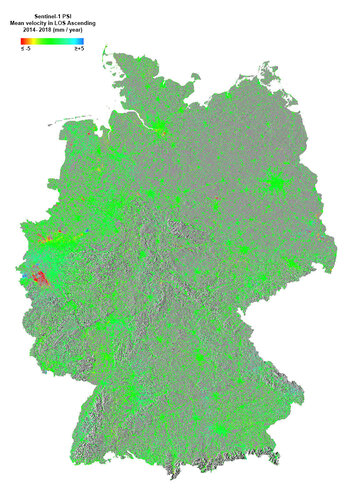
Tiny shifts in the land surface across the whole of Germany have been mapped for the first time, with the help of the Copernicus Sentinel-1 radar mission.
Precise Point Positioning opens up new possibilities for mass market applications
3.11.2020 12:21 European GNSS Agency
Precise Point Positioning is becoming an attractive alternative technique to RTK, removing GNSS system errors to provide global high accuracy positioning, HERE has recently introduced the service HERE HD GNSS Positioning, a cloud-based service that provides sub-meter positioning for devices equipped with GNSS receivers.
Precise Point Positioning (PPP) correction services have been in the market for a long time to either assist vessels maneuver at ports or for measuring instruments for construction and geodesy. Today, highly precise positioning goes beyond industrial use cases and is available to mass market applications and devices.
Precise Point Positioning services remove GNSS system errors to provide higher accuracy positioning using a single receiver. PPP solutions rely on GNSS satellite clock and orbit corrections, generated from a network of global Continuously Operating Reference Stations (CORS). Once the corrections are calculated, they are delivered to the user via satellite or the internet resulting in dm-level or better real-time positioning without the need for a local base station. PPP enables device users to be located within 0.2-1 meter in an open sky environment, instead of the average 3-5 meters to bring higher accuracy. To achieve ambiguity resolution a PPP service might require some time to converge to decimeter accuracy, but it can reach sub meter accuracy in less than a minute. The convergence time required is dependent on the quality of the corrections and how they are applied in the receiver but for many applications is not an issue.
With multi-constellation being the rule rather than the exception, relying on the additional accuracy provided by Galileo and with the use of PPP corrections, businesses can offer decimeter accuracy for safety critical applications such as autonomous or assisted driving.
A recent example of leveraging PPP correction services is HERE HD GNSS Positioning, introduced earlier in 2020 by HERE Technologies. HERE HD GNSS Positioning is a cloud-based service that provides sub-meter positioning for devices equipped with GNSS receivers, so that it can substantially improve positioning accuracy for average mass market devices globally. With HERE HD GNSS Positioning, joggers have a precise location when running in parks, drivers can enjoy accurate lane-level navigation to take the right highway exit, drones can be tracked with greater precision and fleet operators can accurately re-create routes taken by fleets to aid in post-trip analysis. The service works without any expensive equipment and turns regular mobile devices and GNSS-receivers into precise positioning instruments.
As PPP and PPP-RTK providers are already upgrading to Galileo, the introduction of Galileo High Accuracy Service (HAS) in the future will open up a wide variety of opportunities for the creation of new location-based services. HAS will allow users to obtain a positioning error below two decimetres and it will be based on the free transmission of PPP corrections through the Galileo E6-B signal. The corrections will be available over the internet too.
The main specifications of the Galileo E6-B and E6-C codes became available in January 2019 to the Galileo User Community. These codes can be used for accessing the future Galileo High Accuracy Service (HAS) and Galileo Commercial Authentication Service (CAS) and can be downloaded from the Galileo Service Centre (GSC) website under the “Programme Reference Documents” section.
More information about Galileo HAS will be soon available in the High Accuracy Service Information Paper set to be published by the GSA in the coming weeks. The document will offer frequent updates about this new Galileo service.
Media note: This feature can be republished without charge provided the European GNSS Agency (GSA) is acknowledged as the source at the top or the bottom of the story. You must request permission before you use any of the photographs on the site. If you republish, we would be grateful if you could link back to the GSA website (http://www.gsa.europa.eu).
Upozornění
3.11.2020 11:42 ČÚZK - předpisy a opatření Zeměměřický a katastrální inspektorát v Plzni zveřejnil novou aktualitu: Zeměměřický a katastrální inspektorát v Plzni oznamuje, že s ohledem na opatření přijatá usnesením vlády ČR č. 1114 ze dne 30. října 2020 má v době od 4. listopadu 2020 do 20. listopadu 2020 omezený provoz pro veřejnost.Upozornění
3.11.2020 11:42 ČÚZK /Urady/Zememericke-a-katastralni-inspektoraty/Zememericke-a-katastralni-inspektoraty/Zememericky-a-katastralni-inspektorat-v-Plzni/O-uradu/Aktuality/Upozorneni-(3)ESA awards contract to Airbus UK for TRUTHS predevelopment
3.11.2020 11:00 ESA Observing the Earth
ESA and Airbus UK have signed a contract for the TRUTHS satellite mission. Under the contract, Airbus UK will lead the ‘system feasibility and predevelopment’ phase of this new mission. When launched this new mission will establish a climate and calibration observing system to improve confidence in climate-change forecasts.
ČÚZK – krátkodobé přerušení služeb DP a WSDP
3.11.2020 10:38 GEPROČÚZK plánuje přerušit provoz Dálkového přístupu (DP) a Webových služeb dálkového přístupu (WSDP) v pátek 6.… >>
Registrujte se na ONLINE webináře v rámci Dne s INSPIRE
3.11.2020 8:53 CENIA - národní geoportál INSPIRE CENIA, česká informační agentura životního prostředí vás zve na seminář – Den s INSPIRE. Letošní ročník se s ohledem na současné epidemiologické podmínky spojené s COVID-19 uskuteční online, a to ve třech termínech. Připravili jsme pro Vás prezentace zaměřené na INSPIRE metadata 2.0, harmonizaci dat za pomocí programu HALE studio, změny v legislativě a představení katalogu požadavků pro nový...Změna úředních hodin
3.11.2020 8:25 ČÚZK /Urady/Katastralni-urady/Katastralni-urady/Katastralni-urad-pro-Vysocinu/Katastralni-pracoviste/KP-Trebic/O-uradu/Aktuality/Zmena-urednich-hodinZměna úředních hodin
3.11.2020 8:25 ČÚZK - předpisy a opatření Český úřad zeměměřický a katastrální - Katastrální pracoviště Třebíč zveřejnil novou aktualitu:Pozor dočasná změna úředních hodin od 2. 11. 2020:
pondělí 8 - 13 hod
středa 12 - 17 hod
Změna úředních hodin
3.11.2020 8:25 ČÚZK - předpisy a opatření Katastrální úřad pro Vysočinu - Katastrální pracoviště Třebíč zveřejnil novou aktualitu:Pozor dočasná změna úředních hodin od 2. 11. 2020:
pondělí 8 - 13 hod
středa 12 - 17 hod
K dispozici je servicepack SP5
3.11.2020 0:00 SolidVision K dispozici je servicepack SP5 pro SOLIDWORKS 2020. Uživatelé s aktivní předplacenou údržbou si mohou nejaktuálnější servicepack stáhnout na Zákaznickém portále SOLIDWORKS.K dispozici je servicepack SP5
3.11.2020 0:00 SolidVision K dispozici je servicepack SP5 pro SOLIDWORKS 2020. Uživatelé s aktivní předplacenou údržbou si mohou nejaktuálnější servicepack stáhnout na Zákaznickém portále SOLIDWORKS.Informace ke knižním akvizicím [Knihovna geografie, byTopic]
3.11.2020 0:00 Katedra aplikované geoinformatiky a kartografie Přf UK Akvizice, které je možné objednat prostřednictvím Knihovny geografie, se pro tento rok uzavírají k datu 15.11.2020.Prodloužení výpůjček do 1.12.2020 [Knihovna geografie, byTopic]
3.11.2020 0:00 Katedra aplikované geoinformatiky a kartografie Přf UK Vzhledem k prodloužení nouzového stavu a tedy přetrvávajícímu uzavření knihovny byly našim čtenářům prodlouženy výpůjčky do 1. 12. 2020.USGIF Accepting Applications for Annual Scholarship Program
2.11.2020 19:40 GISCafe.com Webcasts-Webinars Herndon, Virginia (November 2, 2020)—The United States Geospatial Intelligence Foundation (USGIF) announces the opening of its 2021 Scholarship …Satellite Remote Sensing Integration With Jain Logic Makes Growers More Productive
2.11.2020 17:15 GISCafe.com Webcasts-Webinars With more than 25,000 global sites, Jain is the only company bringing together satellite imagery with ETc calculations and uniformity, weather, soil …Accela Announces Fall 2020 Product Release to Help Governments Meet Growing Demand for Digital Services Through Modern Citizen Experiences and Analytics
2.11.2020 17:15 GISCafe.com Webcasts-Webinars Govtech veteran delivers extensive mobile, administrative and citizen engagement enhancements; Release includes latest version of Civic Platform, …20201102 - VŘ Metodika KN a zeměměřictví
2.11.2020 17:07 ČÚZK /Aktuality-resort/2020/20201102-VR-Metodika-KN-a-zememerictvi20201102 - VŘ Metodika KN a zeměměřictví
2.11.2020 17:07 ČÚZK - předpisy a opatření Český úřad zeměměřický a katastrální zveřejnil novou aktualitu: Oznámení o vyhlášení výběrového řízení na obsazení služebního místa odborný rada - Metodika KN a zeměměřictví - samostatné projekty.Sea-level rise and Copernicus Sentinel-6
2.11.2020 17:00 ESA Observing the Earth Video:
01:02:31
Video:
01:02:31
Ahead of the impending launch of the Copernicus Sentinel-6 Michael Freilich satellite, join us for live discussions in English, French, German and Italian on the spaceborne technology that measures sea-level rise and how this contributes to our understanding of global climate change. Sea levels have not only been rising over the last years, but accelerating, putting coastal communities and multiple megacities at risk. Sentinel-6 will soon be launched to map, measure and monitor exactly this, so we can understand and mitigate its consequences.
"Starman" - A documentary by Gianluca Cerasola, Morol Srl
"Who we were" - Director, Writer & Producer: Marc Bauder
Production: bauderfilm in coproduction with Hessischen Rundfunk, Rundfunk Berlin-Brandenburg, Südwestrundfunk und arte sowie Hanfgarn& Ufer
Protagonists: Alexander Gerst, Dennis Snower, Matthieu Ricard, Sylvia Earle, Felwine Sarr, Janina Loh
Distributor: X Verleih, Berlin
Sea-level rise and Copernicus Sentinel-6
2.11.2020 17:00 ESA Observing the Earth
Video:
00:01:00
Ahead of the impending launch of the Copernicus Sentinel-6 Michael Freilich satellite, join us for live discussions in English, French, German and Italian on the spaceborne technology that measures sea-level rise and how this contributes to our understanding of global climate change. Sea levels have not only been rising over the last years, but accelerating, putting coastal communities and multiple megacities at risk. Sentinel-6 will soon be launched to map, measure and monitor exactly this, so we can understand and mitigate its consequences.
Director, Writer & Producer: Marc Bauder
Production: bauderfilm in coproduction with Hessischen Rundfunk, Rundfunk Berlin-Brandenburg, Südwestrundfunk und arte sowie Hanfgarn& Ufer
Protagonists: Alexander Gerst, Dennis Snower, Matthieu Ricard, Sylvia Earle, Felwine Sarr, Janina Loh
Distributor: X Verleih, Berlin
Replay: discussing sea-level rise and Sentinel-6
2.11.2020 17:00 ESA Observing the Earth Video:
01:02:31
Video:
01:02:31
Ahead of the impending launch of the Copernicus Sentinel-6 Michael Freilich satellite, join us for live discussions in English, French, German and Italian on the spaceborne technology that measures sea-level rise and how this contributes to our understanding of global climate change. Sea levels have not only been rising over the last years, but accelerating, putting coastal communities and multiple megacities at risk. Sentinel-6 will soon be launched to map, measure and monitor exactly this, so we can understand and mitigate its consequences.
"Starman" - A documentary by Gianluca Cerasola, Morol Srl
"Who we were" - Director, Writer & Producer: Marc Bauder
Production: bauderfilm in coproduction with Hessischen Rundfunk, Rundfunk Berlin-Brandenburg, Südwestrundfunk und arte sowie Hanfgarn& Ufer
Protagonists: Alexander Gerst, Dennis Snower, Matthieu Ricard, Sylvia Earle, Felwine Sarr, Janina Loh
Distributor: X Verleih, Berlin
Přerušení provozu DP a WSDP v pátek 6.11.2020 od 14:30 až do soboty 7.11.2020 do cca 14 hodin
2.11.2020 16:58 ČÚZK /Aplikace-DP-do-KN/Aplikace-DP-do-KN/Archiv-DP/305577Přerušení provozu DP a WSDP v pátek 6.11.2020 od 14:30 až do soboty 7.11.2020 do cca 14 hodin
2.11.2020 16:58 ČÚZK - předpisy a opatření Vážení uživatelé,oznamujeme, že v pátek 6.11.2020 od 14:30 bude z provozních důvodů zcela přerušen provoz Dálkového přístupu i Webových služeb dálkového přístupu. Obnovení provozu předpokládáme v sobotu 7.11.2020 v cca 14:00 hodin.
Za komplikace tímto způsobené se omlouváme a děkujeme za pochopení.
Přerušení provozu DP a WSDP v pátek 6.11.2020 od 14:30 až do soboty 7.11.2020 do cca 14 hodin
2.11.2020 16:58 Dálkový přístup k údajům KN ČR Vážení uživatelé,oznamujeme, že v pátek 6.11.2020 od 14:30 bude z provozních důvodů zcela přerušen provoz Dálkového přístupu i Webových služeb dálkového přístupu. Obnovení provozu předpokládáme v sobotu 7.11.2020 v cca 14:00 hodin.
Za komplikace tímto způsobené se omlouváme a děkujeme za pochopení.
Metodika KN a zeměměřictví - samostatné projekty
2.11.2020 16:55 ČÚZK /Urady/Cesky-urad-zememericky-a-katastralni/Uredni-deska/Oznameni-a-jina-uredni-sdeleni/Volna-mista/DMS/Metodika-KN-a-zememerictvi-samostatne-projektyMetodika KN a zeměměřictví - samostatné projekty
2.11.2020 16:55 ČÚZK - předpisy a opatření Český úřad zeměměřický a katastrálnívypisuje výběrové řízení na místo
Metodika KN a zeměměřictví - samostatné projekty
Metodika KN a zeměměřictví - samostatné projekty
2.11.2020 16:55 ČÚZK - volná místa Český úřad zeměměřický a katastrální vypisuje výběrové řízení na místo Metodika KN a zeměměřictví - samostatné projektyCoreLogic Estimates $2.5 Billion to $4.0 Billion in Insured Losses from Hurricane Zeta Wind and Storm Surge
2.11.2020 15:55 GISCafe.com Webcasts-Webinars Hurricane Zeta is the fifth named storm to strike Louisiana this season, hitting New Orleans head on and causing thousands of power outages.IRVINE, …
Aeva, Maker of the First 4D LiDAR on Chip, to Be Listed on NYSE through Business Combination with InterPrivate Acquisition Corp.
2.11.2020 15:55 GISCafe.com Webcasts-Webinars MOUNTAIN VIEW, Calif., Nov. 2, 2020 — (PRNewswire) —…
New Light Technologies, Dewberry, and National Alliance for Public Safety GIS Foundation Team win FEMA contract to provide Disaster Modeling, Analytics, Systems Development, and Training Services
2.11.2020 15:55 GISCafe.com Webcasts-Webinars WASHINGTON, Nov. 2, 2020 — (PRNewswire) — New Light Technologies Inc. (NLT), a leading provider of integrated cloud, cybersecurity, …20201104 - Omezení z důvodu pandemické situace v ČR od 4.11.2020
2.11.2020 14:17 ČÚZK - předpisy a opatření Český úřad zeměměřický a katastrální zveřejnil novou aktualitu: S ohledem na vývoj pandemické situace v ČR Vás prosíme, abyste katastrální pracoviště navštěvovali jen v nejnutnějších případech a dali přednost zaslání podání elektronicky nebo poštou. Výpis z katastru v elektronické podobě je možno získat v e-shopu Nahlížení do katastru. V souladu s usnesením vlády ČR č. 1114 ze dne 30. října 2020 budou mít všechny katastrální úřady od 4. listopadu 2020 úřední dny pouze v pondělí a ve středu, před návštěvou si prosím ověřte přesný rozsah úředních hodin na www stránkách příslušných katastrálních úřadů. Děkujeme za pochopení20201104 - Omezení z důvodu pandemické situace v ČR od 4.11.2020
2.11.2020 14:17 ČÚZK /Aktuality-resort/2020/Omezeni-z-duvodu-pandemicke-situace-v-CR-od-4-11-2odborný referent v oddělení právních vztahů k nemovitostem
2.11.2020 13:43 ČÚZK /Urady/Katastralni-urady/Katastralni-urady/Katastralni-urad-pro-Liberecky-kraj/Uredni-deska/Oznameni-a-jina-uredni-sdeleni/Volna-mista/odborny-referent-v-oddeleni-pravnich-vztahu-k-(2)odborný referent v oddělení právních vztahů k nemovitostem
2.11.2020 13:43 ČÚZK - volná místa Katastrální úřad pro Liberecký kraj - Katastrální pracoviště Liberec vypisuje výběrové řízení na místo odborný referent v oddělení právních vztahů k nemovitostemodborný referent v oddělení právních vztahů k nemovitostem
2.11.2020 13:43 ČÚZK - předpisy a opatření Katastrální úřad pro Liberecký kraj - Katastrální pracoviště Liberecvypisuje výběrové řízení na místo
odborný referent v oddělení právních vztahů k nemovitostem
Aktuality pracoviště
2.11.2020 13:10 ČÚZK - předpisy a opatření Český úřad zeměměřický a katastrální - Katastrální pracoviště Velké Meziříčí zveřejnil novou aktualitu: Důležité upozornění!S účinností od 2. listopadu 2020 dochází na Katastrálním pracovišti Velké Meziříčí ke změně omezení úředních hodin v období nouzového stavu více na úřední desce
Aktuality pracoviště
2.11.2020 13:10 ČÚZK - předpisy a opatření Katastrální úřad pro Vysočinu - Katastrální pracoviště Velké Meziříčí zveřejnil novou aktualitu: Důležité upozornění!S účinností od 2. listopadu 2020 dochází na Katastrálním pracovišti Velké Meziříčí ke změně omezení úředních hodin v období nouzového stavu více na úřední desce
Aktuality pracoviště
2.11.2020 13:10 ČÚZK /Urady/Katastralni-urady/Katastralni-urady/Katastralni-urad-pro-Vysocinu/Katastralni-pracoviste/KP-Velke-Mezirici/O-uradu/Aktuality/Aktuality-pracoviste-(2)Nedostupnost WSDP na zkoušku od úterý 3.11.2020 do soboty 7.11.2020.
2.11.2020 12:29 Dálkový přístup k údajům KN ČR Vážení uživatelé webových služeb,oznamujeme, že od úterý 3.11.2020 od 7 hodin do soboty 7.11.2020 do cca 18 hodin nebudou dostupné webové služby na zkoušku.
Omlouváme se za komplikace a děkujeme za pochopení.
Nedostupnost WSDP na zkoušku od úterý 3.11.2020 do soboty 7.11.2020.
2.11.2020 12:29 ČÚZK - předpisy a opatření Vážení uživatelé webových služeb,oznamujeme, že od úterý 3.11.2020 od 7 hodin do soboty 7.11.2020 do cca 18 hodin nebudou dostupné webové služby na zkoušku.
Omlouváme se za komplikace a děkujeme za pochopení.
Nedostupnost WSDP na zkoušku od úterý 3.11.2020 do soboty 7.11.2020.
2.11.2020 12:29 ČÚZK /Aplikace-DP-do-KN/Aplikace-DP-do-KN/Archiv-DP/305514Aktuality pracoviště
2.11.2020 12:03 ČÚZK - předpisy a opatření Katastrální úřad pro Vysočinu - Katastrální pracoviště Velké Meziříčí zveřejnil novou aktualitu:Důležité upozornění!
Informace katastrálního úřadu k zjišťování průběhu hranic v katastrálním území Ruda u Velkého Meziříčí více na úřední desce
Aktuality pracoviště
2.11.2020 12:03 ČÚZK /Urady/Katastralni-urady/Katastralni-urady/Katastralni-urad-pro-Vysocinu/Katastralni-pracoviste/KP-Velke-Mezirici/O-uradu/Aktuality/UpozorneniAktuality pracoviště
2.11.2020 12:03 ČÚZK - předpisy a opatření Český úřad zeměměřický a katastrální - Katastrální pracoviště Velké Meziříčí zveřejnil novou aktualitu:Důležité upozornění!
Informace katastrálního úřadu k zjišťování průběhu hranic v katastrálním území Ruda u Velkého Meziříčí více na úřední desce
Aktuality pracoviště
2.11.2020 12:03 ČÚZK - předpisy a opatření Český úřad zeměměřický a katastrální - Katastrální pracoviště Velké Meziříčí zveřejnil novou aktualitu:Důležité upozornění!
Informace katastrálního úřadu k zjišťování průběhu hranic v katastrálním území Ruda u Velkého Meziříčí
Upozornění
2.11.2020 12:03 ČÚZK /Urady/Katastralni-urady/Katastralni-urady/Katastralni-urad-pro-Vysocinu/Katastralni-pracoviste/KP-Velke-Mezirici/O-uradu/Aktuality/UpozorneniAktuality pracoviště
2.11.2020 12:03 ČÚZK - předpisy a opatření Český úřad zeměměřický a katastrální - Katastrální pracoviště Velké Meziříčí zveřejnil novou aktualitu:Důležité upozornění!
Informace katastrálního úřadu k zjišťování průběhu hranic v katastrálním území Ruda u Velkého Meziříčí více na úřední desce
Informace pro klienty
2.11.2020 11:40 ČÚZK - předpisy a opatření Katastrální úřad pro Moravskoslezský kraj - Katastrální pracoviště Ostrava zveřejnil novou aktualitu: Po dobu omezených úředních hodin ode dne 2. 11. 2020 je na Katastrálním pracovišti Ostrava pro příjem podání k dispozici schránka (sběrný box), umístěná na vstupních dveřích do budovy katastrálního úřadu. Tato schránka je v pravidelných intervalech vybírána – v každou celou hodinu v pondělí až čtvrtek od 8:00 do 15:00 hod. a v pátek od 8:00 do 12:00 hod. (okamžik podání je k okamžiku výběru schránky). Přijetí podání bude potvrzeno na e-mail, bude-li v návrhu na vklad nebo na jiném podání uveden.Informace pro klienty
2.11.2020 11:40 ČÚZK - předpisy a opatření Katastrální úřad pro Moravskoslezský kraj - Katastrální pracoviště Ostrava zveřejnil novou aktualitu: Informace pro klienty:Po dobu omezených úředních hodin ode dne 2. 11. 2020 je na Katastrálním pracovišti Ostrava pro příjem podání k dispozici schránka (sběrný box), umístěná na vstupních dveřích do budovy katastrálního úřadu. Tato schránka je v pravidelných intervalech vybírána – v každou celou hodinu v pondělí až čtvrtek od 8:00 do 15:00 hod. a v pátek od 8:00 do 12:00 hod. (okamžik podání je k okamžiku výběru schránky). Přijetí podání bude potvrzeno na e-mail, bude-li v návrhu na vklad nebo na jiném podání uveden.
Informace pro klienty
2.11.2020 11:40 ČÚZK /Urady/Katastralni-urady/Katastralni-urady/Katastralni-urad-pro-Moravskoslezsky-kraj/Katastralni-pracoviste/KP-Ostrava/O-uradu/Aktuality/Informace-pro-klientyInformace pro klienty
2.11.2020 11:40 ČÚZK - předpisy a opatření Katastrální úřad pro Moravskoslezský kraj - Katastrální pracoviště Ostrava zveřejnil novou aktualitu: Informace pro klienty:Po dobu omezených úředních hodin ode dne 2. 11. 2020 je na Katastrálním pracovišti Ostrava pro příjem podání k dispozici schránka (sběrný box), umístěná na vstupních dveřích do budovy katastrálního úřadu. Tato schránka je v pravidelných intervalech vybírána – v každou celou hodinu v pondělí až čtvrtek od 8:00 do 15:00 hod. a v pátek od 8:00 do 12:00 hod. (okamžik podání je k okamžiku výběru schránky). Přijetí podání bude potvrzeno na e-mail, bude-li v návrhu na vklad nebo na jiném podání uveden.
Rada/odborný rada-vedoucí oddělení aktualizace KN na Katastrálním pracoviši Kyjov
2.11.2020 11:38 ČÚZK - předpisy a opatření Katastrální úřad pro Jihomoravský kraj Katastrální pracoviště Kyjovvypisuje výběrové řízení na místo
Rada/odborný rada-vedoucí oddělení aktualizace KN na Katastrálním pracoviši Kyjov
Rada/odborný rada-vedoucí oddělení aktualizace KN na Katastrálním pracoviši Kyjov
2.11.2020 11:38 ČÚZK /Urady/Katastralni-urady/Katastralni-urady/Katastralni-urad-pro-Jihomoravsky-kraj/Uredni-deska/Oznameni-a-jina-uredni-sdeleni/Volna-mista/DMS/Rada-odborny-rada-vedouci-oddeleni-aktualizace-KNRada/odborný rada-vedoucí oddělení aktualizace KN na Katastrálním pracoviši Kyjov
2.11.2020 11:38 ČÚZK - volná místa Katastrální úřad pro Jihomoravský kraj Katastrální pracoviště Kyjov vypisuje výběrové řízení na místo Rada/odborný rada-vedoucí oddělení aktualizace KN na Katastrálním pracoviši KyjovFollow live discussions: Sea-level rise and Sentinel-6
2.11.2020 10:45 ESA Observing the Earth
Ahead of the impending launch of the Copernicus Sentinel-6 Michael Freilich satellite, join us for a live discussion on the spaceborne technology that measures sea-level rise and how this contributes to our understanding of global climate change.