


![]()

zprávy
zdroje zpráv:20201009 - změna úředních hodin od 12.10.2020
9.10.2020 13:37 ČÚZK /Urady/Katastralni-urady/Katastralni-urady/Katastralni-urad-pro-Ustecky-kraj/Katastralni-pracoviste/KP-Decin/O-uradu/Aktuality/20201009-zmena-urednich-hodin-od-12-10-202020201009 - změna úředních hodin od 12.10.2020
9.10.2020 13:37 ČÚZK - předpisy a opatření Katastrální úřad pro Ústecký kraj - Katastrální pracoviště Děčín zveřejnil novou aktualitu: S účinností od 12.10.2020 je provedena změna Úředních hodin na pracovištích Katastrálního úřadu pro Ústecký kraj.Úřední hodiny jsou nově pro všechny agendy:
Pondělí : 8:00 - 17:00
Středa : 8:00 - 17:00
Upozorňujeme na možnost učinit podání bezkontaktně do schránky umístěné v hale budovy! Lze tak podat i návrh na vklad v zalepené obálce. Uveďte v podání Váš mail, budeme Vás informovat o přijetí, případně vyzveme k zaplacení poplatku převodem na účet. Schránka je přístupná ve vstupní hale v pondělí a středu od 8:00 – 17:00, v úterý a čtvrtek od 8:00 – 14:00 a v pátek od 8:00 do 12:00.
20201009 - změna úředních hodin od 12.10.2020
9.10.2020 13:37 ČÚZK - předpisy a opatření Katastrální úřad pro Ústecký kraj - Katastrální pracoviště Děčín zveřejnil novou aktualitu: S účinností od 12.10.2020 je provedena změna Úředních hodin na pracovištích Katastrálního úřadu pro Ústecký kraj.Úřední hodiny jsou nově pro všechny agendy:
Pondělí : 8:00 - 17:00
Středa : 8:00 - 17:00
Upozorňujeme na možnost učinit podání bezkontaktně do schránky umístěné v hale budovy! Lze tak podat i návrh na vklad v zalepené obálce. Uveďte v podání Váš mail, budeme Vás informovat o přijetí, případně vyzveme k zaplacení poplatku převodem na účet. Schránka je přístupná v pondělí a středu od 8:00 – 17:00, v úterý a čtvrtek od 8:00 – 14:00 a v pátek od 8:00 do 12:00.
SBĚRNÝ BOX
9.10.2020 13:35 ČÚZK - předpisy a opatření Katastrální úřad pro Středočeský kraj - Katastrální pracoviště Mladá Boleslav zveřejnil novou aktualitu: SBĚRNÝ BOX pro podání KP MLADÁ BOLESLAVVážení klienti, v budově úřadu byla umístěna schránka pro bezkontaktní příjem podání. Do této schránky můžete vkládat svá písemná podání V UZAVŘENÉ OBÁLCE. Lze tak podat i návrh na vklad. Schránka je pravidelně vybírána.
V podání uveďte Váš e-mail, budeme Vás informovat o přijetí, případně vyzveme k zaplacení poplatku převodem na účet.
Schránka je přístupná v pondělí a ve středu 8 – 17 hod., v úterý a ve čtvrtek 8 – 14 hod., v pátek 8 – 12 hod.
SBĚRNÝ BOX
9.10.2020 13:35 ČÚZK - předpisy a opatření Katastrální úřad pro Středočeský kraj - Katastrální pracoviště Mladá Boleslav zveřejnil novou aktualitu: SBĚRNÝ BOX pro podání KP MLADÁ BOLESLAVVážení klienti, v budově úřadu byla umístěna schránka pro bezkontaktní příjem podání. Do této schránky můžete vkládat svá písemná podání V UZAVŘENÉ OBÁLCE. Lze tak podat i návrh na vklad. Schránka je pravidelně vybírána.
V podání uveďte Váš e-mail, budeme Vás informovat o přijetí, případně vyzveme k zaplacení poplatku převodem na účet.
Schránka je přístupná v pondělí a ve středu 8 – 17 hod., v úterý a ve čtvrtek 8 – 13 hod., v pátek 8 – 12 hod.
SBĚRNÝ BOX
9.10.2020 13:35 ČÚZK /Urady/Katastralni-urady/Katastralni-urady/Katastralni-urad-pro-Stredocesky-kraj/Katastralni-pracoviste/KP-Mlada-Boleslav/O-uradu/Aktuality/SBERNY-BOXSBĚRNÝ BOX
9.10.2020 13:35 ČÚZK - předpisy a opatření Katastrální úřad pro Středočeský kraj - Katastrální pracoviště Mladá Boleslav zveřejnil novou aktualitu: SBĚRNÝ BOX pro podání KP MLADÁ BOLESLAVVážení klienti, v budově úřadu je i nadále k dispozici schránka pro bezkontaktní příjem podání. Do této schránky můžete vkládat svá písemná podání V UZAVŘENÉ OBÁLCE. Lze tak podat i návrh na vklad. Schránka je pravidelně vybírána.
V podání uveďte Váš e-mail, budeme Vás informovat o přijetí, případně vyzveme k zaplacení poplatku převodem na účet.
Schránka je přístupná v pondělí a ve středu 8 – 17 hod., v úterý a ve čtvrtek 8 – 14 hod., v pátek 8 – 12 hod.
Mapová aplikace ÚPD - nové dokumentace
9.10.2020 13:30 Jihočeský kraj V mapové aplikaci Územně plánovací dokumentace obcí byla aktualizována ÚPD obcí ORP České Budějovice – Radošovice, ZáboříUpozornění
9.10.2020 13:16 ČÚZK - předpisy a opatření Katastrální úřad pro Plzeňský kraj zveřejnil novou aktualitu: Katastrální úřad pro Plzeňský kraj od 12. 10. 2020 upravuje úřední hodiny katastrálních pracovišť.Upozornění
9.10.2020 13:16 ČÚZK - předpisy a opatření Český úřad zeměměřický a katastrální zveřejnil novou aktualitu: Katastrální úřad pro Plzeňský kraj od 12. 10. 2020 upravuje úřední hodiny katastrálních pracovišt.Upozornění
9.10.2020 13:16 ČÚZK - předpisy a opatření Katastrální úřad pro Plzeňský kraj zveřejnil novou aktualitu: Katastrální úřad pro Plzeňský kraj od 12. 10. 2020 upravuje úřední hodiny katastrálních pracovišt.Změna úředních hodin
9.10.2020 13:05 ČÚZK - předpisy a opatření Katastrální úřad pro Jihomoravský kraj zveřejnil novou aktualitu: Z důvodu vyhlášených krizových opatření se omezují úřední hodiny katastrálních pracovišť Katastrálního úřadu pro Jihomoravský kraj na pondělí a středu od 8:00 do 17:00Změna úředních hodin
9.10.2020 13:05 ČÚZK /Urady/Katastralni-urady/Katastralni-urady/Katastralni-urad-pro-Jihomoravsky-kraj/O-uradu/Aktuality/Zmena-urednich-hodinZměna úředních hodin
9.10.2020 13:05 ČÚZK - předpisy a opatření Katastrální úřad pro Jihomoravský kraj zveřejnil novou aktualitu: Z důvodu vyhlášených krizových opatření se omezují úřední hodiny katastrálních pracovišť Katastrálního úřadu pro Jihomoravský kraj na pondělí a středu od 8:00 do 17:00Vždy nahoře - Pozor změna úředních hodin. od 09.10 2020 ->...
9.10.2020 12:46 ČÚZK - předpisy a opatření Katastrální úřad pro hlavní město Prahu zveřejnil novou aktualitu: Pozor změna úředních hodin.Vždy nahoře - Pozor změna úředních hodin. od 09.10 2020 ->...
9.10.2020 12:46 ČÚZK /Urady/Katastralni-urady/Katastralni-urady/Katastralni-urad-pro-hlavni-mesto-Prahu/O-uradu/Aktuality/Vzdy-nahore-Pozor-zmena-urednich-hodin-od-09-1Vždy nahoře - Pozor změna úředních hodin. od 09.10 2020 ->...
9.10.2020 12:46 ČÚZK - předpisy a opatření Katastrální úřad pro hlavní město Prahu zveřejnil novou aktualitu: Pozor změna úředních hodin.Vždy nahoře - Pozor změna úředních hodin. od 09.10 2020 ->...
9.10.2020 12:46 ČÚZK - předpisy a opatření Katastrální úřad pro hlavní město Prahu zveřejnil novou aktualitu: Pozor změna úředních hodin.Zástup za mateřskou a rodičovskou dovolenou na služebním místě návrh zápisu v katastru – NZK1302
9.10.2020 12:22 ČÚZK - volná místa Katastrální úřad pro Plzeňský kraj - Katastrální pracoviště Rokycany vypisuje výběrové řízení na místo Zástup za mateřskou a rodičovskou dovolenou na služebním místě návrh zápisu v katastru – NZK1302Zástup za mateřskou a rodičovskou dovolenou na služebním místě návrh zápisu v katastru – NZK1302
9.10.2020 12:22 ČÚZK /Urady/Katastralni-urady/Katastralni-urady/Katastralni-urad-pro-Plzensky-kraj/Volna-mista/DMS/Zastup-za-materskou-a-rodicovskou-dovolenou-na-sluZástup za mateřskou a rodičovskou dovolenou na služebním místě návrh zápisu v katastru – NZK1302
9.10.2020 12:22 ČÚZK - předpisy a opatření Katastrální úřad pro Plzeňský kraj Katastrální pracoviště Rokycanyvypisuje výběrové řízení na místo
Zástup za mateřskou a rodičovskou dovolenou na služebním místě návrh zápisu v katastru – NZK1302
Zástup za mateřskou a rodičovskou dovolenou na služebním místě návrh zápisu v katastru – NZK1302
9.10.2020 12:22 ČÚZK - předpisy a opatření Katastrální úřad pro Plzeňský kraj - Katastrální pracoviště Rokycanyvypisuje výběrové řízení na místo
Zástup za mateřskou a rodičovskou dovolenou na služebním místě návrh zápisu v katastru – NZK1302
omezení úředních hodin
9.10.2020 12:18 ČÚZK /Urady/Katastralni-urady/Katastralni-urady/Katastralni-urad-pro-Moravskoslezsky-kraj/Katastralni-pracoviste/KP-Trinec/O-uradu/Aktuality/omezeni-urednich-hodinomezení úředních hodin
9.10.2020 12:18 ČÚZK - předpisy a opatření Katastrální úřad pro Moravskoslezský kraj - Katastrální pracoviště Třinec zveřejnil novou aktualitu:Při osobním kontaktu Vás žádáme o dodržování hygienických zásad a respektování pokynů našich zaměstnanců.
Děkujeme za pochopení.
omezení úředních hodin
9.10.2020 12:18 ČÚZK - předpisy a opatření Katastrální úřad pro Moravskoslezský kraj - Katastrální pracoviště Třinec zveřejnil novou aktualitu:I nadále upřednostňujeme bezkontaktní způsob podání (poštou, elektronicky).
Při osobním kontaktu Vás žádáme o dodržování hygienických zásad a respektování pokynů našich zaměstnanců.
Děkujeme za pochopení.
omezení úředních hodin
9.10.2020 12:17 ČÚZK /Urady/Katastralni-urady/Katastralni-urady/Katastralni-urad-pro-Moravskoslezsky-kraj/Katastralni-pracoviste/KP-Ostrava/O-uradu/Aktuality/omezeni-urednich-hodinomezení úředních hodin
9.10.2020 12:17 ČÚZK - předpisy a opatření Katastrální úřad pro Moravskoslezský kraj - Katastrální pracoviště Ostrava zveřejnil novou aktualitu:I nadále upřednostňujeme bezkontaktní způsob podání (poštou, elektronicky).
Při osobním kontaktu Vás žádáme o dodržování hygienických zásad a respektování pokynů našich zaměstnanců.
Děkujeme za pochopení.
omezení úředních hodin
9.10.2020 12:17 ČÚZK - předpisy a opatření Katastrální úřad pro Moravskoslezský kraj - Katastrální pracoviště Ostrava zveřejnil novou aktualitu:Při osobním kontaktu Vás žádáme o dodržování hygienických zásad a respektování pokynů našich zaměstnanců.
Děkujeme za pochopení.
omezení úředních hodin
9.10.2020 12:16 ČÚZK - předpisy a opatření Katastrální úřad pro Moravskoslezský kraj - Katastrální pracoviště Opava zveřejnil novou aktualitu:Při osobním kontaktu Vás žádáme o dodržování hygienických zásad a respektování pokynů našich zaměstnanců.
Děkujeme za pochopení.
omezení úředních hodin
9.10.2020 12:16 ČÚZK /Urady/Katastralni-urady/Katastralni-urady/Katastralni-urad-pro-Moravskoslezsky-kraj/Katastralni-pracoviste/KP-Opava/O-uradu/Aktuality/omezeni-urednich-hodinomezení úředních hodin
9.10.2020 12:16 ČÚZK - předpisy a opatření Katastrální úřad pro Moravskoslezský kraj - Katastrální pracoviště Opava zveřejnil novou aktualitu:I nadále upřednostňujeme bezkontaktní způsob podání (poštou, elektronicky).
Při osobním kontaktu Vás žádáme o dodržování hygienických zásad a respektování pokynů našich zaměstnanců.
Děkujeme za pochopení.
Zástup za mateřskou a rodičovskou dovolenou na služebním místě návrh zápisu v katastru – NZK1302
9.10.2020 12:16 ČÚZK - volná místa Katastrální úřad pro Plzeňský kraj Katastrální pracoviště Rokycany vypisuje výběrové řízení na místo Zástup za mateřskou a rodičovskou dovolenou na služebním místě návrh zápisu v katastru – NZK1302omezení úředních hodin
9.10.2020 12:15 ČÚZK - předpisy a opatření Katastrální úřad pro Moravskoslezský kraj - Katastrální pracoviště Nový Jičín zveřejnil novou aktualitu:I nadále upřednostňujeme bezkontaktní způsob podání (poštou, elektronicky).
Při osobním kontaktu Vás žádáme o dodržování hygienických zásad a respektování pokynů našich zaměstnanců.
Děkujeme za pochopení.
omezení úředních hodin
9.10.2020 12:15 ČÚZK /Urady/Katastralni-urady/Katastralni-urady/Katastralni-urad-pro-Moravskoslezsky-kraj/Katastralni-pracoviste/KP-Novy-Jicin/O-uradu/Aktuality/omezeni-urednich-hodinomezení úředních hodin
9.10.2020 12:15 ČÚZK - předpisy a opatření Katastrální úřad pro Moravskoslezský kraj - Katastrální pracoviště Nový Jičín zveřejnil novou aktualitu:Při osobním kontaktu Vás žádáme o dodržování hygienických zásad a respektování pokynů našich zaměstnanců.
Děkujeme za pochopení.
omezení úředních hodin
9.10.2020 12:14 ČÚZK /Urady/Katastralni-urady/Katastralni-urady/Katastralni-urad-pro-Moravskoslezsky-kraj/Katastralni-pracoviste/KP-Krnov/O-uradu/Aktuality/omezeni-urednich-hodinomezení úředních hodin
9.10.2020 12:14 ČÚZK - předpisy a opatření Katastrální úřad pro Moravskoslezský kraj - Katastrální pracoviště Krnov zveřejnil novou aktualitu:Při osobním kontaktu Vás žádáme o dodržování hygienických zásad a respektování pokynů našich zaměstnanců.
Děkujeme za pochopení.
omezení úředních hodin
9.10.2020 12:14 ČÚZK - předpisy a opatření Katastrální úřad pro Moravskoslezský kraj - Katastrální pracoviště Krnov zveřejnil novou aktualitu:I nadále upřednostňujeme bezkontaktní způsob podání (poštou, elektronicky).
Při osobním kontaktu Vás žádáme o dodržování hygienických zásad a respektování pokynů našich zaměstnanců.
Děkujeme za pochopení.
omezení úředních hodin
9.10.2020 12:13 ČÚZK /Urady/Katastralni-urady/Katastralni-urady/Katastralni-urad-pro-Moravskoslezsky-kraj/Katastralni-pracoviste/KP-Karvina/O-uradu/Aktuality/omezeni-urednich-hodinomezení úředních hodin
9.10.2020 12:13 ČÚZK - předpisy a opatření Katastrální úřad pro Moravskoslezský kraj - Katastrální pracoviště Karviná zveřejnil novou aktualitu:I nadále upřednostňujeme bezkontaktní způsob podání (poštou, elektronicky).
Při osobním kontaktu Vás žádáme o dodržování hygienických zásad a respektování pokynů našich zaměstnanců.
Děkujeme za pochopení.
omezení úředních hodin
9.10.2020 12:13 ČÚZK - předpisy a opatření Katastrální úřad pro Moravskoslezský kraj - Katastrální pracoviště Karviná zveřejnil novou aktualitu:Při osobním kontaktu Vás žádáme o dodržování hygienických zásad a respektování pokynů našich zaměstnanců.
Děkujeme za pochopení.
omezení úředních hodin
9.10.2020 12:12 ČÚZK - předpisy a opatření Katastrální úřad pro Moravskoslezský kraj - Katastrální pracoviště Frýdek-Místek zveřejnil novou aktualitu:I nadále upřednostňujeme bezkontaktní způsob podání (poštou, elektronicky).
Při osobním kontaktu Vás žádáme o dodržování hygienických zásad a respektování pokynů našich zaměstnanců.
Děkujeme za pochopení.
omezení úředních hodin
9.10.2020 12:12 ČÚZK /Urady/Katastralni-urady/Katastralni-urady/Katastralni-urad-pro-Moravskoslezsky-kraj/Katastralni-pracoviste/KP-Frydek-Mistek/O-uradu/Aktuality/omezeni-urednich-hodinomezení úředních hodin
9.10.2020 12:12 ČÚZK - předpisy a opatření Katastrální úřad pro Moravskoslezský kraj - Katastrální pracoviště Frýdek-Místek zveřejnil novou aktualitu:Při osobním kontaktu Vás žádáme o dodržování hygienických zásad a respektování pokynů našich zaměstnanců.
Děkujeme za pochopení.
omezení úředních hodin
9.10.2020 12:10 ČÚZK - předpisy a opatření Katastrální úřad pro Moravskoslezský kraj - Katastrální pracoviště Bruntál zveřejnil novou aktualitu:Při osobním kontaktu Vás žádáme o dodržování hygienických zásad a respektování pokynů našich zaměstnanců.
Děkujeme za pochopení.
omezení úředních hodin
9.10.2020 12:10 ČÚZK /Urady/Katastralni-urady/Katastralni-urady/Katastralni-urad-pro-Moravskoslezsky-kraj/Katastralni-pracoviste/KP-Bruntal/O-uradu/Aktuality/omezeni-urednich-hodinomezení úředních hodin
9.10.2020 12:10 ČÚZK - předpisy a opatření Katastrální úřad pro Moravskoslezský kraj - Katastrální pracoviště Bruntál zveřejnil novou aktualitu:I nadále upřednostňujeme bezkontaktní způsob podání (poštou, elektronicky).
Při osobním kontaktu Vás žádáme o dodržování hygienických zásad a respektování pokynů našich zaměstnanců.
Děkujeme za pochopení.
Omezení úředních hodin 12.-25.10.2020
9.10.2020 12:09 ČÚZK /Urady/Zememericke-a-katastralni-inspektoraty/Zememericke-a-katastralni-inspektoraty/Zememericky-a-katastralni-inspektorat-v-Pardubicic/O-uradu/Aktuality/Omezeni-urednich-hodin-12-25-10-2020Omezení úředních hodin 12.-25.10.2020
9.10.2020 12:09 ČÚZK - předpisy a opatření Zeměměřický a katastrální inspektorát v Pardubicích zveřejnil novou aktualitu: Omezení úředních hodinVážení klienti,
s účinností od pondělí 12.10.2020 jsou úřední hodiny podatelny i úřední hodiny pro veřejnost stanoveny takto:
Pondělí: 8:00 - 13:00
Je upřednostňován písemný, elektronický či telefonický kontakt před kontaktem osobním.
Pozor změna úředních hodin. Vždy nahoře od 09.10 2020 ->...
9.10.2020 12:06 ČÚZK - předpisy a opatření Katastrální úřad pro hlavní město Prahu - Katastrální pracoviště Praha zveřejnil novou aktualitu: Pozor změna úředních hodin.Pozor změna úředních hodin. Vždy nahoře od 09.10 2020 ->...
9.10.2020 12:06 ČÚZK - předpisy a opatření Katastrální úřad pro hlavní město Prahu - Katastrální pracoviště Praha zveřejnil novou aktualitu: Pozor změna úředních hodin.Pozor změna úředních hodin. 09.10 2020 ->...
9.10.2020 12:06 ČÚZK /Urady/Katastralni-urady/Katastralni-urady/Katastralni-urad-pro-hlavni-mesto-Prahu/Katastralni-pracoviste/KP-Praha/O-uradu/Aktuality/Pozor-zmena-urednich-hodin-09-10-2020Pozor změna úředních hodin. Vždy nahoře od 09.10 2020 ->...
9.10.2020 12:06 ČÚZK - předpisy a opatření Katastrální úřad pro hlavní město Prahu - Katastrální pracoviště Prahazveřejnil novou aktualitu: Pozor změna úředních hodin.
Pozor změna úředních hodin. 09.10 2020 ->...
9.10.2020 12:06 ČÚZK - předpisy a opatření Katastrální úřad pro hlavní město Prahu - Katastrální pracoviště Praha zveřejnil novou aktualitu: Pozor změna úředních hodin.Pozor změna úředních hodin. Vždy nahoře od 09.10 2020 ->...
9.10.2020 12:06 ČÚZK - předpisy a opatření Katastrální úřad pro hlavní město Prahu - Katastrální pracoviště Praha zveřejnil novou aktualitu: Pozor změna úředních hodin.Pozor změna úředních hodin. Vždy nahoře od 09.10 2020 ->...
9.10.2020 12:06 ČÚZK /Urady/Katastralni-urady/Katastralni-urady/Katastralni-urad-pro-hlavni-mesto-Prahu/Katastralni-pracoviste/KP-Praha/O-uradu/Aktuality/Pozor-zmena-urednich-hodin-09-10-2020omezení úředních hodin
9.10.2020 11:58 ČÚZK /Urady/Katastralni-urady/Katastralni-urady/Katastralni-urad-pro-Moravskoslezsky-kraj/O-uradu/Aktuality/omezeni-urednich-hodinomezení úředních hodin
9.10.2020 11:58 ČÚZK - předpisy a opatření Katastrální úřad pro Moravskoslezský kraj zveřejnil novou aktualitu:Při osobním kontaktu Vás žádáme o dodržování hygienických zásad a respektování pokynů našich zaměstnanců.
Děkujeme za pochopení.
omezení úředních hodin
9.10.2020 11:58 ČÚZK - předpisy a opatření Katastrální úřad pro Moravskoslezský kraj zveřejnil novou aktualitu:I nadále upřednostňujeme bezkontaktní způsob podání (poštou, elektronicky).
Při osobním kontaktu Vás žádáme o dodržování hygienických zásad a respektování pokynů našich zaměstnanců.
Děkujeme za pochopení.
20201009 - omezení chodu úřadu
9.10.2020 11:49 ČÚZK - předpisy a opatření Katastrální úřad pro Karlovarský kraj - Katastrální pracoviště Karlovy Vary zveřejnil novou aktualitu: Upozornění Katastrálního pracoviště!Od 12.10.2020 dochází na Katastrálním pracovišti Karlovy vary k omezení služeb pro veřejnost.
Více informací: Získat podrobnější informace k omezení služeb pro veřejnost (soubor ve formátu PDF)
20201009 - omezení chodu úřadu
9.10.2020 11:49 ČÚZK /Urady/Katastralni-urady/Katastralni-urady/Katastralni-urad-pro-Karlovarsky-kraj/Katastralni-pracoviste/KP-Karlovy-Vary/O-uradu/Aktuality/20201009-omezeni-chodu-uradu20201009 - omezení chodu úřadu
9.10.2020 11:49 ČÚZK - předpisy a opatření Katastrální úřad pro Karlovarský kraj - Katastrální pracoviště Karlovy Vary zveřejnil novou aktualitu: Upozornění Katastrálního pracoviště!Od 12.10.2020 dochází na Katastrálním pracovišti Karlovy vary k omezení služeb pro veřejnost.
Více informací: ODKAZ
Omezení úředních hodin 12.-25.10.2020
9.10.2020 11:45 ČÚZK - předpisy a opatření Katastrální úřad pro Pardubický kraj zveřejnil novou aktualitu: Omezení úředních hodin Vážení klienti,na základě usnesení vlády ČR budou úření hodiny
pouze PONDĚLÍ a STŘEDA v době od 8:00 do 17:00 hodin.
S účiností od 12.10.2020 do 25.10.2020.
Děkujeme za pochopení.
Omezení úředních hodin 12.-25.10.2020
9.10.2020 11:45 ČÚZK /Urady/Katastralni-urady/Katastralni-urady/Katastralni-urad-pro-Pardubicky-kraj/O-uradu/Aktuality/Omezeni-urednich-hodin-12-25-10-202020201009 - omezení chodu úřadu
9.10.2020 11:18 ČÚZK /Urady/Katastralni-urady/Katastralni-urady/Katastralni-urad-pro-Karlovarsky-kraj/O-uradu/Aktuality/20201009-omezeni-chodu-uradu20201009 - omezení chodu úřadu
9.10.2020 11:18 ČÚZK - předpisy a opatření Katastrální úřad pro Karlovarský kraj zveřejnil novou aktualitu: Upozornění Katastrálního úřadu!Od 12.10.2020 dochází na Katastrálním úřadu pro Karlovarský kraj k omezení služeb pro veřejnost.
Více informací: Získat podrobnější informace k omezení služeb pro veřejnost (soubor ve formátu PDF)
Děkujeme za pochopení.
20201009 - omezení chodu úřadu
9.10.2020 11:18 ČÚZK - předpisy a opatření Katastrální úřad pro Karlovarský kraj zveřejnil novou aktualitu: Upozornění Katastrálního úřadu!Od 12.10.2020 dochází na Katastrálním úřadu pro Karlovarský kraj k omezení služeb pro veřejnost.
Více informací: ODKAZ
Děkujeme za pochopení.
upozorneni_OH
9.10.2020 11:13 ČÚZK - předpisy a opatření Zeměměřický úřad zveřejnil novou aktualitu: Důležité upozornění!S ohledem na opatření přijatá usnesením vlády ČR č. 994 ze dne 8. října 2020 je v době od pondělí 12. října 2020 do pátku 23. října 2020 omezený provoz pro veřejnost, a to následovně:
pondělí: 8:00 - 17:00
středa: 8:00 - 17:00
Děkujeme za pochopení.
upozorneni_OH
9.10.2020 11:13 Zeměměřický úřad Zeměměřický úřad zveřejnil novou aktualitu: Důležité upozornění!S ohledem na opatření přijatá usnesením vlády ČR č. 994 ze dne 8. října 2020 je v době od pondělí 12. října 2020 do pátku 23. října 2020 omezený provoz pro veřejnost, a to následovně:
pondělí: 8:00 - 17:00
středa: 8:00 - 17:00
Děkujeme za pochopení.
20201009 - omezení chodu úřadu
9.10.2020 11:00 ČÚZK - předpisy a opatření Katastrální úřad pro Karlovarský kraj - Katastrální pracoviště Cheb zveřejnil novou aktualitu: Upozornění Katastrálního pracoviště!Od 12.10.2020 dochází na Katastrálním pracovišti Cheb k omezení služeb pro veřejnost.
Více informací: ODKAZ
20201009 - omezení chodu úřadu
9.10.2020 11:00 ČÚZK /Urady/Katastralni-urady/Katastralni-urady/Katastralni-urad-pro-Karlovarsky-kraj/Katastralni-pracoviste/KP-Cheb/O-uradu/Aktuality/20201009-omezeni-chodu-uradu20201009 - omezení chodu úřadu
9.10.2020 11:00 ČÚZK - předpisy a opatření Katastrální úřad pro Karlovarský kraj - Katastrální pracoviště Cheb zveřejnil novou aktualitu: Upozornění Katastrálního pracoviště!Od 12.10.2020 dochází na Katastrálním pracovišti Cheb k omezení služeb pro veřejnost.
Více informací: Získat podrobnější informace k omezení služeb pro veřejnost (soubor ve formátu PDF)
referent KN – vedení DKM, vedení katastrální mapy (*2)
9.10.2020 10:35 ČÚZK /Urady/Katastralni-urady/Katastralni-urady/Katastralni-urad-pro-hlavni-mesto-Prahu/Uredni-deska/Oznameni-a-jina-uredni-sdeleni/Volna-mista/DMS/referent-KN-–-vedeni-DKM,-vedeni-katastralni-m-(1)referent KN – vedení DKM, vedení katastrální mapy (11. plat. třída)
9.10.2020 10:35 ČÚZK /Urady/Katastralni-urady/Katastralni-urady/Katastralni-urad-pro-hlavni-mesto-Prahu/Uredni-deska/Oznameni-a-jina-uredni-sdeleni/Volna-mista/DMS/referent-KN-–-vedeni-DKM,-vedeni-katastralni-m-(1)referent KN – vedení DKM, vedení katastrální mapy (stejnojmenný název)
9.10.2020 10:35 ČÚZK - volná místa Katastrální úřad pro hlavní město Prahu vypisuje výběrové řízení na místo referent KN – vedení DKM, vedení katastrální mapy (stejnojmenný název)referent KN – vedení DKM, vedení katastrální mapy (*2)
9.10.2020 10:35 ČÚZK - předpisy a opatření Katastrální úřad pro hlavní město Prahuvypisuje výběrové řízení na místo
referent KN – vedení DKM, vedení katastrální mapy (*2)
referent KN – vedení DKM, vedení katastrální mapy (stejnojmenný název)
9.10.2020 10:35 ČÚZK - předpisy a opatření Katastrální úřad pro hlavní město Prahuvypisuje výběrové řízení na místo
referent KN – vedení DKM, vedení katastrální mapy (stejnojmenný název)
referent KN – vedení DKM, vedení katastrální mapy (*2)
9.10.2020 10:35 ČÚZK - volná místa Katastrální úřad pro hlavní město Prahu vypisuje výběrové řízení na místo referent KN – vedení DKM, vedení katastrální mapy (*2)referent KN – vedení DKM, vedení katastrální mapy (stejnojmenný název)
9.10.2020 10:35 ČÚZK /Urady/Katastralni-urady/Katastralni-urady/Katastralni-urad-pro-hlavni-mesto-Prahu/Uredni-deska/Oznameni-a-jina-uredni-sdeleni/Volna-mista/DMS/referent-KN-–-vedeni-DKM,-vedeni-katastralni-m-(1)referent KN – vedení DKM, vedení katastrální mapy (11. plat. třída)
9.10.2020 10:35 ČÚZK - volná místa Katastrální úřad pro hlavní město Prahu vypisuje výběrové řízení na místo referent KN – vedení DKM, vedení katastrální mapy (11. plat. třída)referent KN – vedení DKM, vedení katastrální mapy (11. plat. třída)
9.10.2020 10:35 ČÚZK - předpisy a opatření Katastrální úřad pro hlavní město Prahuvypisuje výběrové řízení na místo
referent KN – vedení DKM, vedení katastrální mapy (11. plat. třída)
20201009 - Seznam oprávněných zeměměřických inženrů
9.10.2020 10:19 ČÚZK - aktuality v resortu Aktualizovaný seznam úředně oprávněných zeměměřických inženýrů.referent KN – vedení DKM, vedení katastrální mapy
9.10.2020 10:15 ČÚZK - předpisy a opatření Katastrální úřad pro hlavní město Prahuvypisuje výběrové řízení na místo
referent KN – vedení DKM, vedení katastrální mapy
referent KN – vedení DKM, vedení katastrální mapy
9.10.2020 10:15 ČÚZK - volná místa Katastrální úřad pro hlavní město Prahu vypisuje výběrové řízení na místo referent KN – vedení DKM, vedení katastrální mapy20201009 - Upozornění Covid
9.10.2020 10:13 ČÚZK - aktuality v resortu Důležité upozornění!20201009 - Upozornění Covid
9.10.2020 10:13 ČÚZK - předpisy a opatření Český úřad zeměměřický a katastrální zveřejnil novou aktualitu: Důležité upozornění!ESA call to demonstrate positioning and timing capabilities of coming 5G networks
9.10.2020 10:05 ESA Navigation
ESA has launched a call for proposals to demonstrate the capabilities of new 5G cellular networks to support positioning and timing applications to complement satellite navigation, just as today’s smartphones harness cellular data to support their positioning services.
Úřední hodiny od 12.10.2020
9.10.2020 10:01 ČÚZK - předpisy a opatření Katastrální úřad pro Královéhradecký kraj zveřejnil novou aktualitu:pro Královéhradecký kraj
v návaznosti na Usnesení vlády ČR ze dne 8. 10. 2020 o přijetí krizového opatření oznamuje:
Všechna katastrální pracoviště v územní působnosti Katastrálního úřadu pro Královéhradecký kraj mají nadále omezeny služby vyžadující přímý kontakt s veřejností.
Na Katastrálních pracovištích Hradec Králové, Náchod, Rychnov nad Kněžnou a Trutnov jsou úřední hodiny od 12. 10. 2020 stanoveny takto: pondělí a středa od 8:00 do 13:00, na Katastrálním pracovišti Jičín: pondělí od 9:00 do 14:00 a středa od 10:00 do 15:00.
Úřední hodiny od 12.10.2020
9.10.2020 10:01 ČÚZK /Urady/Katastralni-urady/Katastralni-urady/Katastralni-urad-pro-Kralovehradecky-kraj/O-uradu/Aktuality/Uredni-hodiny-od-12-10-2020Úřední hodiny od 12.10.2020
9.10.2020 10:01 ČÚZK - předpisy a opatření Katastrální úřad pro Královéhradecký kraj zveřejnil novou aktualitu:pro Královéhradecký kraj
v návaznosti na Usnesení vlády ČR ze dne 8. 10. 2020 o přijetí krizového opatření oznamuje:
Všechna katastrální pracoviště v územní působnosti Katastrálního úřadu pro Královéhradecký kraj mají nadále omezeny služby vyžadující přímý kontakt s veřejností.
Na Katastrálních pracovištích Hradec Králové, Náchod, Rychnov nad Kněžnou a Trutnov jsou úřední hodiny od 12. 10. 2020 stanoveny takto: pondělí a středa od 8:00 do 17:00, na Katastrálním pracovišti Jičín: pondělí od 9:00 do 14:00 a středa od 10:00 do 15:00.
Earth from Space: Laguna San Rafael National Park, Chile
9.10.2020 10:00 ESA Observing the Earth Video:
00:03:49
Video:
00:03:49
In this week's edition of the Earth from Space programme, we explore part of the Laguna San Rafael National Park, Chile, with Copernicus Sentinel-2.
See also Laguna San Rafael National Park, Chile to download the image.
Laguna San Rafael National Park, Chile
9.10.2020 10:00 ESA Observing the Earth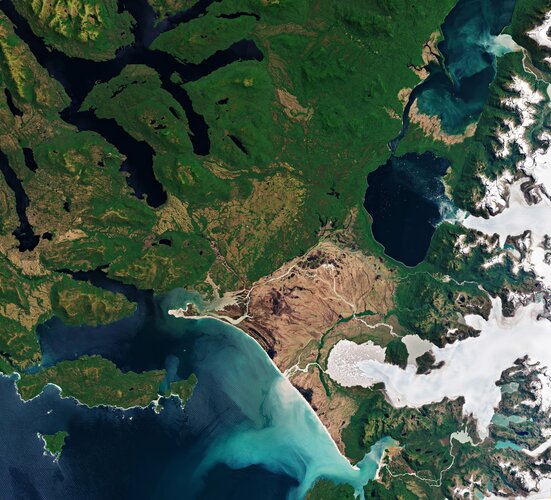 Image:
Part of the Laguna San Rafael National Park, located on the Pacific coast of southern Chile, is pictured in this image captured by Copernicus Sentinel-2.
Image:
Part of the Laguna San Rafael National Park, located on the Pacific coast of southern Chile, is pictured in this image captured by Copernicus Sentinel-2.
20201009 - Seznam oprávněných zeměměřických inženrů
9.10.2020 9:11 ČÚZK /Aktuality-resort/2020/20201009-Seznam-opravnenych-zememerickych-inzenr20201009 - Seznam oprávněných zeměměřických inženrů
9.10.2020 9:11 ČÚZK - předpisy a opatření Český úřad zeměměřický a katastrální zveřejnil novou aktualitu: Aktualizovaný seznam úředně oprávněných zeměměřických inženýrů.Omezení služeb pro veřejnost od 04.11.2020
9.10.2020 9:05 ČÚZK - předpisy a opatření Katastrální úřad pro Karlovarský kraj - Katastrální pracoviště Sokolov zveřejnil novou aktualitu: Upozornění Katastrálního pracoviště!Od 04.11.2020 dochází na Katastrálním pracovišti Sokolov k omezení služeb pro veřejnost.
Více informací: Získat podrobnější informace k omezení služeb pro veřejnost (soubor ve formátu PDF)
Omezení služeb pro veřejnost od 12.10.2020
9.10.2020 9:05 ČÚZK - předpisy a opatření Katastrální úřad pro Karlovarský kraj - Katastrální pracoviště Sokolov zveřejnil novou aktualitu: Upozornění Katastrálního pracoviště!Od 12.10.2020 dochází na Katastrálním pracovišti Sokolov k omezení služeb pro veřejnost.
Více informací: Získat podrobnější informace k omezení služeb pro veřejnost (soubor ve formátu PDF)
Omezení služeb pro veřejnost od 12.10.2020
9.10.2020 9:05 ČÚZK - předpisy a opatření Katastrální úřad pro Karlovarský kraj - Katastrální pracoviště Sokolov zveřejnil novou aktualitu: Upozornění Katastrálního pracoviště!Od 26.10.2020 dochází na Katastrálním pracovišti Sokolov k omezení služeb pro veřejnost.
Více informací: Získat podrobnější informace k omezení služeb pro veřejnost (soubor ve formátu PDF)
Omezení služeb pro veřejnost od 04.11.2020
9.10.2020 9:05 ČÚZK /Urady/Katastralni-urady/Katastralni-urady/Katastralni-urad-pro-Karlovarsky-kraj/Katastralni-pracoviste/KP-Sokolov/O-uradu/Aktuality/Omezeni-sluzeb-pro-verejnost-od-12-10-2020Omezení služeb pro veřejnost od 04.11.2020
9.10.2020 9:05 ČÚZK - předpisy a opatření Katastrální úřad pro Karlovarský kraj - Katastrální pracoviště Sokolov zveřejnil novou aktualitu: Upozornění Katastrálního pracoviště!Od 04.11.2020 dochází na Katastrálním pracovišti Sokolov k omezení služeb pro veřejnost.
Více informací: Získat podrobnější informace k omezení služeb pro veřejnost (soubor ve formátu PDF)
Omezení služeb pro veřejnost od 12.10.2020
9.10.2020 9:05 ČÚZK /Urady/Katastralni-urady/Katastralni-urady/Katastralni-urad-pro-Karlovarsky-kraj/Katastralni-pracoviste/KP-Sokolov/O-uradu/Aktuality/Omezeni-sluzeb-pro-verejnost-od-12-10-2020Omezení služeb pro veřejnost od 12.10.2020
9.10.2020 9:05 ČÚZK - předpisy a opatření Český úřad zeměměřický a katastrální - Katastrální pracoviště Sokolov zveřejnil novou aktualitu: Omezení služeb pro veřejnost od 12.10.2020.ODKAZ NA DOKUMENT
Omezení služeb pro veřejnost od 10.12.2020
9.10.2020 9:05 ČÚZK /Urady/Katastralni-urady/Katastralni-urady/Katastralni-urad-pro-Karlovarsky-kraj/Katastralni-pracoviste/KP-Sokolov/O-uradu/Aktuality/Omezeni-sluzeb-pro-verejnost-od-12-10-2020Omezení služeb pro veřejnost od 04.11.2020
9.10.2020 9:05 ČÚZK - předpisy a opatření Katastrální úřad pro Karlovarský kraj - Katastrální pracoviště Sokolov zveřejnil novou aktualitu: Upozornění Katastrálního pracoviště!Od 23.11.2020 dochází na Katastrálním pracovišti Sokolov k omezení služeb pro veřejnost.
Více informací: Získat podrobnější informace k omezení služeb pro veřejnost (soubor ve formátu PDF)
Omezení služeb pro veřejnost od 12.10.2020
9.10.2020 9:05 ČÚZK - předpisy a opatření Katastrální úřad pro Karlovarský kraj - Katastrální pracoviště Sokolov zveřejnil novou aktualitu: Upozornění Katastrálního pracoviště!Od 26.10.2020 dochází na Katastrálním pracovišti Sokolov k omezení služeb pro veřejnost.
Více informací: Získat podrobnější informace k omezení služeb pro veřejnost (soubor ve formátu PDF)
Omezení služeb pro veřejnost od 10.12.2020
9.10.2020 9:05 ČÚZK - předpisy a opatření Katastrální úřad pro Karlovarský kraj - Katastrální pracoviště Sokolov zveřejnil novou aktualitu: Upozornění Katastrálního pracoviště!Do 23.12.2020 dochází na Katastrálním pracovišti Sokolov k omezení služeb pro veřejnost.
Více informací: Získat podrobnější informace k omezení služeb pro veřejnost (soubor ve formátu PDF)
Omezení služeb pro veřejnost od 12.10.2020
9.10.2020 9:05 ČÚZK - předpisy a opatření Český úřad zeměměřický a katastrální - Katastrální pracoviště Sokolov zveřejnil novou aktualitu: Upozornění Katastrálního pracoviště!Od 12.10.2020 dochází na Katastrálním pracovišti Sokolov k omezení služeb pro veřejnost.
Více informací: Získat podrobnější informace k omezení služeb pro veřejnost (soubor ve formátu PDF)
vyhlášení výběrového řízení na služební místo ředitel/ředitelka Katastrálního pracoviště Pelhřimov
9.10.2020 6:22 ČÚZK /Urady/Katastralni-urady/Katastralni-urady/Katastralni-urad-pro-Vysocinu/O-uradu/Aktuality/vyhlaseni-vyberoveho-rizeni-na-sluzebni-misto-redivyhlášení výběrového řízení na služební místo ředitel/ředitelka Katastrálního pracoviště Pelhřimov
9.10.2020 6:22 ČÚZK - předpisy a opatření Katastrální úřad pro Vysočinu zveřejnil novou aktualitu: Oznámení o vyhlášení výběrového řízení na služební místo rada/odborný rada – ředitel/ředitelka Katastrálního pracoviště Pelhřimov na Katastrálním úřadu pro Vysočinu, místo výkonu služby Pelhřimov.General Dynamics at AUSA 2020: Enabling the Army Now to Deploy, Fight and Win
9.10.2020 0:21 GISCafe.com Webcasts-Webinars RESTON, Va., Oct. 8, 2020 — (PRNewswire) — Four business units of General Dynamics (NYSE:GD) will participate in the Association of the …Dálkový průzkum Země pro sledování výkyvů v zemědělské produkci. Výzva #11 v Covid-19 INSPIRE hackathonu
9.10.2020 0:13 GeoBusinessPandemie covid-19 a hlavně následná omezení byla a jsou i nadále zkouškou potravinového dodavatelského řetězce s cílem poskytnout dostatek potravin na trh koncovým zákazníkům. Zejména v krizových situacích lze dobré rozhodnutí učinit pouze s dostatečným množstvím informací. V předchozích INSPIRE hackatonech byly vytvořeny mapy výnosového potenciálu. Tyto potenciální výnosy jsou velmi náchylné k sezónním vlivům, […]
The post Dálkový průzkum Země pro sledování výkyvů v zemědělské produkci. Výzva #11 v Covid-19 INSPIRE hackathonu appeared first on GeoBusiness.
Nové úřední hodiny po dobu trvání Usnesení vlády
9.10.2020 0:00 Státní pozemkový úřad V souladu s Usnesením vlády ČR ze dne 8. října 2020 č. 994, o přijetí krizového opatření upravujeme od pondělí 12. října 2020 úřední hodiny! Zároveň doporučujeme přednostně využívat elektronické formy komunikace. Více informací naleznete v příloze "Nové úřední hodiny a způsoby komunikace". Děkujeme za pochopení.Vizualizace atraktivity venkova. Výzva #4 hackathonu Covid-19 INSPIRE Hackathon 2020
8.10.2020 22:31 GeoBusinessV pondělí 12. října se uskuteční webinář (registrace) ke čtvrté výzvě Covid-19 INSPIRE Hackathonu, tentokrát se týkající projektu PoliRural. Projekt PoliRural pro tuto výzvu číslo 4 (celkem je v hackathonu výzev třináct) připravil datový soubor, popisující atraktivitu venkova v Evropě z různých perspektiv, například z pohledu demografie, přírodního kapitálu, sociálního kapitálu, ekonomického pohledu, zemědělství či […]
The post Vizualizace atraktivity venkova. Výzva #4 hackathonu Covid-19 INSPIRE Hackathon 2020 appeared first on GeoBusiness.
Geospatial World Forum 2021 set to be held physically in Amsterdam
8.10.2020 16:09 GISCafe.com Webcasts-Webinars October 8, 2020: Geospatial World Forum, the premier annual gathering of geospatial professionals, is set to be held physically in Amsterdam, The …CoreLogic Risk Analysis Shows Hurricane Delta Threatens 293,685 Homes with Storm Surge Damage
8.10.2020 16:08 GISCafe.com Webcasts-Webinars —With striking similarities to Hurricane Laura, Hurricane Delta threatens the same coastal towns already struggling to recover—IRVINE, Calif. …