


![]()

zprávy
zdroje zpráv:Roter Kamm impact crater
30.6.2020 10:00 ESA Observing the Earth Image:
On Asteroid Day, the Copernicus Sentinel-2 mission takes us over the Roter Kamm impact crater in Namibia.
Image:
On Asteroid Day, the Copernicus Sentinel-2 mission takes us over the Roter Kamm impact crater in Namibia.
20200630-Seznam úředně oprávněných inženýrů
30.6.2020 8:37 ČÚZK /Aktuality-resort/2020/20200630-Seznam-uredne-opravnenych-inzenyru20200630-Seznam úředně oprávněných inženýrů
30.6.2020 8:37 ČÚZK - předpisy a opatření Český úřad zeměměřický a katastrální zveřejnil novou aktualitu: Aktualizovaný seznam úředně oprávněných zeměměřických inženýrů.Výběrové řízení - Inspektor/ka – právník Zeměměřického a katastrálního inspektorátu v Praze
30.6.2020 8:02 ČÚZK - předpisy a opatření Zeměměřický a katastrální inspektorát v Praze zveřejnil novou aktualitu: Oznámení o vyhlášení výběrového řízení na obsazení služebního místa Inspektor/ka – právník Zeměměřického a katastrálního inspektorátu v Praze (obor služby 55.)Map of the Month: Retail share of private consumption, Europe 2019
30.6.2020 1:14 GISCafe.com Webcasts-Webinars GfK’s Map of the Month for June illustrates the brick-and-mortar retail turnover share of private consumption in Europe in 2019.According to …
Call for Sponsors of Testbed-17: Collaborate and Innovate to Advance the Power of Location
30.6.2020 1:13 GISCafe.com Webcasts-Webinars Join with geospatial experts to solve your organization’s technology challenges and shape the future of location technologies
29 …
Harmonogram státních závěrečných zkoušek - magisterské studium
30.6.2020 0:00 Geografický ústav MUByl zvěřejněn harmonogram státních závěrečných zkoušek Mgr. studia.
New Esri ArcGIS Field Maps beta supports Eos Arrow GNSS location and metadata!
29.6.2020 20:48 GISCafe.com Webcasts-Webinars June 29, 2020 -- We have exciting news for our joint customers of Esri and Eos Positioning Systems. Last week, our business partner Esri announced a …"Pix4D Releases Pix4Dcloud and Pix4Dcloud Advanced Mapping Platforms" by Susan Smith
29.6.2020 19:32 GISCafe.com Webcasts-WebinarsIndustrial Internet Consortium Publishes White Paper Detailing Smart Factory Web Testbed Standards
29.6.2020 16:46 GISCafe.com Webcasts-Webinars Standards-based testbed enables factories to develop new business models, win partnersNEEDHAM, Mass., June 29, 2020 — (PRNewswire) — …
ODOT Selects Woolpert for 2-Year Statewide Safety Design Contract
29.6.2020 16:46 GISCafe.com Webcasts-Webinars The firm will provide multidisciplinary services to reduce traffic crashes throughout Ohio.COLUMBUS, Ohio, June 29, 2020 — (PRNewswire) …
Volná místa - 29.06.2020
29.6.2020 14:54 ČÚZK /Urady/Katastralni-urady/Katastralni-urady/Katastralni-urad-pro-hlavni-mesto-Prahu/O-uradu/Aktuality/Volna-mista-29-06-2020Volná místa - 29.06.2020
29.6.2020 14:54 ČÚZK - předpisy a opatření Katastrální úřad pro Jihočeský kraj - Katastrální pracoviště Praha-východ zveřejnil novou aktualitu: Volná místa:* odborný referent/vrchní referent – zápis do protokolu řízení V a Z
Podrobnosti zde
A “Cerealist’s Diary”, the testimony of a wheat farmer
29.6.2020 14:52 European GNSS Agency
A cereal farmer in Salamanca, Spain, explains how satellite navigation systems help farmers to reduce CO2 emissions and save time and money, and demonstrates how EGNOS currently plays an important role in European agriculture, helping farms to improve crop yields while reducing their environmental footprint.
We met with Fernando Benito, a cereal farmer in Spain, who spoke to us about how EGNOS supports the entire wheat production cycle by facilitating various tasks such as ploughing, fertilizing, sowing and spraying.
EGNOS, the preferred entry technology for precision farming
EGNOS, with its sub-metre level accuracy (20-30 cm pass-to-pass), offers an affordable solution for some of the field work required by precision agriculture. EGNOS allows farmers to better monitor their harvest yields, perform effective in-field data collection and use guidance in cultivation. It also increases their efficiency, allowing them to work in poor visibility or bad weather conditions, while increasing productivity, lowering costs and minimising environmental impact - all with minimal investment.
In the words of Fernando: “EGNOS allows me to save time and money across all my tasks. Thanks to its precision guidance it enables the correct dissemination of fertilizer and phytosanitary products, thus avoiding overlaps and errors. EGNOS is very easy to use and to configure, it saves me resources and time.”
To benefit from the EGNOS service, all you need is an SBAS-enabled antenna and a receiver properly configured to receive the signal. For those interested in equipment configuration details, guidelines can be downloaded through this link. You can also download GEAR, an interactive (and free) virtual demonstrator that allows you to have fun experiencing various farming tasks under different weather conditions, while showcasing the benefits of EGNOS for machinery guidance. If you want to calculate how much money you can save by using EGNOS on your farm, try the EASE tool. This software provides a cost-benefit analysis by comparing the results achieved through EGNOS+GPS guidance versus GPS alone.
Fernando added: “I can say that EGNOS is a tool that meets the requirements of my crops at low cost. It provides me with the precision I need at all times throughout the season, so I would recommend it to other cereal farmers.”
The agriculture sector has been one of the fastest to adopt satellite navigation services. This is confirmed by the fact the vast majority of agricultural GNSS devices on board farming machinery today are EGNOS-enabled and EGNOS is fast becoming the preferred entry-level technology for sustainable precision agriculture in Europe.
Watch the video here.
A “Cerealist’s Diary”, the testimony of a farmer working in his wheat harvest
29.6.2020 14:52 European GNSS AgencyA European cereal farmer in Salamanca, Spain, is explaining how satellite navigation systems help farmers to reduce CO2 emissions, as well as save time and money, demonstrating how EGNOS today plays an important role in European agriculture, helping farmers to increase their productivity while being more sustainable for the environment.
Meeting Fernando Benito, a cereal farmer in Spain, we have listened to him presenting how EGNOS supports him during a crop harvest by facilitating various tasks such as ploughing, fertilizing, sowing and spraying.
EGNOS, the preferred entry technology for precision farming
EGNOS, with its sub-metre level accuracy (20-30 cm pass-to-pass), offers an affordable solution for some of the field works required today by precision agriculture. EGNOS allows farmers to better monitor their harvest yields, perform effective in-field data collection, use guidance in cultivation, increase efficiency (allowing to work in poor visibility/weather conditions), increase productiveness, lower costs and minimise environmental impact - all with minimal investment.
As Fernando Benito, the cereal producer and protagonist of our video stated: “EGNOS allows me to save time and money during all the tasks carried out as it is very precise in the guidance, therefore it allows a correct dissemination of fertilizer and phytosanitary products, thus avoiding overlaps and faults. It is very easy to use and to configure, therefore it helps me save time”
To benefit from EGNOS service, all you need is an SBAS-enabled antenna and a receiver properly configured to receive the signal. For those interested in equipment configuration details, guidelines can be downloaded through this link. You can also download GEAR, an interactive (and free) virtual demonstrator which, in a friendly way, allows you to experience in an entertaining way some farming tasks under different weather conditions while showcasing the benefits of EGNOS for machinery guidance. If you want to calculate how much money you save thanks to using EGNOS in your farm, try the “EASE tool“. This software provides cost-benefit analysis by comparing the results achieved through an EGNOS+GPS guidance versus a “GPS alone” one.
That is why Fernando Benito, the cereal producer, also added: “I can say that EGNOS is the tool that meets the requirements of my crops at low cost. It provides me with the precision I need at all times throughout the season, so I would recommend it to other cereal farmers.”
The agriculture sector has been one of the fastest to use satellite navigation services in recent years. This is confirmed by the fact the vast majority of agricultural GNSS devices, on board farming machinery on the market today, are EGNOS enabled and it is becoming the preferred entry level technology for a sustainable precision agriculture in Europe.
Watch the video here.
odborný referent/vrchní referent – zápis do protokolu řízení V a Z
29.6.2020 14:52 ČÚZK - volná místa Katastrální úřad pro hlavní město Prahu Katastrální pracoviště Praha vypisuje výběrové řízení na místo odborný referent/vrchní referent – zápis do protokolu řízení V a Zodborný referent/vrchní referent – zápis do protokolu řízení V a Z
29.6.2020 14:52 ČÚZK - předpisy a opatření Katastrální úřad pro hlavní město Prahu Katastrální pracoviště Prahavypisuje výběrové řízení na místo
odborný referent/vrchní referent – zápis do protokolu řízení V a Z
20200629 - Novinky ve verzi 3.0
29.6.2020 14:05 ČÚZK - předpisy a opatření Instalace nové verze ISÚI do produkčního prostředí proběhla 25. 6. 2020. V sekci 1. Editační agendový systém ISÚI byl publikován nový dokument "Novinky ve verzi 3.0" a aktualizován "ISÚI - přiručka pro uživatele". V sekci Uživatelské postupy v ISÚI byl publikován nový dokument "Statistiky chyb v ISÚI" a aktualizován "Řešení reklamací".20200629 - Novinky ve verzi 3.0
29.6.2020 14:05 ČÚZK - předpisy a opatření Instalace nové verze ISÚI do produkčního prostředí proběhla 25. 6. 2020. V sekci 1. Editační agendový systém ISÚI byl publikován nový dokument "Novinky ve verzi 3.0" a aktualizován "ISÚI - přiručka pro uživatele". V sekci Uživatelské postupy v ISÚI byl publikován nový dokument "Statistiky chyb v ISÚI" a aktualizován "Řešení reklamací".20200629 - Novinky ve verzi 3.0
29.6.2020 14:05 ČÚZK - předpisy a opatření20200629 - Novinky ve verzi 3.0
29.6.2020 14:05 ČÚZK /Uvod/Produkty-a-sluzby/RUIAN/RUIAN-novinky/2020/20200629-Novinky-ve-verzi-3-020200629 - Novinky ve verzi 3.0
29.6.2020 14:05 ČÚZK - předpisy a opatření Instalace nové verze ISÚI do produkčního prostředí proběhla 25. 6. 2020. V sekci 1. Editační agendový systém ISÚI byl publikován nový dokument "Novinky ve verzi 3.0" a aktualizován "ISÚI - přiručka pro uživatele". V sekci Uživatelské postupy v ISÚI byl publikován nový dokument "Statistiky chyb v ISÚI" a aktualizován "Řešení reklamací".Nominace na ocenění Mapa roku 2019
29.6.2020 13:50 Česká kartografická společnost Česká kartografická společnost v letošním roce uspořádala 22. ročník soutěže Mapa roku. Odborná komise na svém červnovém zasedání zhodnotila přihlášená kartografická díla vydaná na území České republiky v roce 2019 a určila nominace a vítěze v jednotlivých kategoriích. Z důvodu protipandemických opatření byl termín pro hodnocení produktů i pro vyhlášení výsledků soutěže oproti předchozím ročníkům posunut. Slavnostní vyhlášení výsledků […]Výběrové řízení na služební místo odborný referent/vrchní referent v oddělení aktualizace PI KN č.2
29.6.2020 11:23 ČÚZK - předpisy a opatření Katastrální úřad pro Jihomoravský kraj Katastrální pracoviště Brno-venkovvypisuje výběrové řízení na místo
Výběrové řízení na služební místo odborný referent/vrchní referent v oddělení aktualizace PI KN č.2 na Katastrálním pracovišti Brno - venkov
Výběrové řízení na služební místo odborný referent/vrchní referent v oddělení aktualizace PI KN č.2
29.6.2020 11:23 ČÚZK /Urady/Katastralni-urady/Katastralni-urady/Katastralni-urad-pro-Jihomoravsky-kraj/Uredni-deska/Oznameni-a-jina-uredni-sdeleni/Volna-mista/DMS/Vyberove-rizeni-na-sluzebni-misto-odborny-referentVýběrové řízení na služební místo odborný referent/vrchní referent v oddělení aktualizace PI KN č.2
29.6.2020 11:23 ČÚZK - volná místa Katastrální úřad pro Jihomoravský kraj Katastrální pracoviště Brno-venkov vypisuje výběrové řízení na místo Výběrové řízení na služební místo odborný referent/vrchní referent v oddělení aktualizace PI KN č.2Výběrové řízení na služební místo rada/odborný rada - ředitel/ka Katastrálního pracoviště Vyškov
29.6.2020 11:17 ČÚZK - volná místa Katastrální úřad pro Jihomoravský kraj Katastrální pracoviště Vyškov vypisuje výběrové řízení na místo Výběrové řízení na služební místo rada/odborný rada - ředitel/ka Katastrálního pracoviště VyškovVýběrové řízení na služební místo rada/odborný rada - ředitel/ka Katastrálního pracoviště Vyškov
29.6.2020 11:17 ČÚZK /Urady/Katastralni-urady/Katastralni-urady/Katastralni-urad-pro-Jihomoravsky-kraj/Uredni-deska/Oznameni-a-jina-uredni-sdeleni/Volna-mista/DMS/Vyberove-rizeni-na-sluzebni-misto-rada-odborny-radVýběrové řízení na služební místo rada/odborný rada - ředitel/ka Katastrálního pracoviště Vyškov
29.6.2020 11:17 ČÚZK - předpisy a opatření Katastrální úřad pro Jihomoravský kraj Katastrální pracoviště Vyškovvypisuje výběrové řízení na místo
Výběrové řízení na služební místo rada/odborný rada - ředitel/ka Katastrálního pracoviště Vyškov
Revize katastru nemovitostí. Přehled práv a povinností, které máte při revizi KN
29.6.2020 10:55 Asociace podnikatelů v geomatice Asociace podnikatelů v geomatice a její pracovní skupina pro vzdělávání vydala přehledný návod, zaměřený na revize katastru. Dokument, vysvětlující různé situace v souvislosti s revizemi, je k dispozici ve formátu PDF.Revize katastru nemovitostí. Přehled práv a povinností, které máte při revizi KN
29.6.2020 10:55 Asociace podnikatelů v geomatice Asociace podnikatelů v geomatice a její pracovní skupina pro vzdělávání vydala přehledný návod, zaměřený na revize katastru. Dokument, vysvětlující různé situace v souvislosti s revizemi, je k dispozici online a ve formátu PDF.Prohlížecí služba Esri ArcGIS Server - Historická jména
29.6.2020 2:00 Cenia - Katalog metadat ČR - INSPIRE Prohlížecí služba AGS - Historická jména je poskytována jako veřejná prohlížecí služba nad aktuálními daty produktu Databáze geografických jmen České republiky (Geonames) a archivními mapami a ortofoty. Službu lze využít prostřednictvím přístupových rozhraní REST, SOAP a WMS.Prohlížecí služba WMS- Historická jména
29.6.2020 2:00 Cenia - Katalog metadat ČR - INSPIRE Prohlížecí služba WMS - Historická jména je poskytována jako veřejná prohlížecí služba nad aktuálními daty produktu Databáze geografických jmen České republiky (Geonames) a archivními mapami a ortofoty.APGEO - Revize katastru nemovitostí. Přehled práv a povinností, které máte při revizi KN
29.6.2020 2:00 Asociace podnikatelů v geomatice Asociace podnikatelů v geomatice a její pracovní skupina pro vzdělávání vydala přehledný návod, zaměřený na revize ...Omezení provozu pobočky Brno, Oddělení půdní služby Brno, Oddělení správy dat, Oddělení vodohospodářských staveb - omezení provozu
29.6.2020 0:00 Státní pozemkový úřadLaunch of Kleos Development Technology beginning of July
26.6.2020 17:19 GISCafe.com Webcasts-Webinars Launch of Kleos Development Technology beginning of JulyKleos Space to launch new data collecting technology as a ‘hosted …
CoreLogic Raises Second Quarter 2020 Financial Guidance
26.6.2020 16:21 GISCafe.com Webcasts-Webinars Significant Increases in Revenue and Profitability Driven by Top Line Growth, Market Share Gains, Favorable Mix, and Margin ExpansionIRVINE, Calif. …
Trimble Opens Registration for a Virtual Edition of its Annual in.sight user conference + expo
26.6.2020 16:21 GISCafe.com Webcasts-Webinars This Year's Transportation Virtual Event Will Be Held in AugustSUNNYVALE, Calif., June 26, 2020 — (PRNewswire) — Trimble (NASDAQ: TRMB) …
Jsme součástí dvou mezinárodních konsorcií na Urban Air Mobility v H2020 a SESAR výzvách
26.6.2020 13:46 UpVisionKarenténu jsme naplno využili desítkami konferenčních hovorů se zástupci takových společností jako je Airbus, DLR, Honeywell, Lilium, Hexagon, Airmap a dalšími téměř 40-ti evropskými společnostmi, univerzitami a městy jako účastník v rámci dvou podaných návrhů projektů do výzev SESARu a H2020 na Urban Air Mobility. Kromě těchto projektů je Jakub zastoupen v dalších dvou návrzích projektů na […]
The post Jsme součástí dvou mezinárodních konsorcií na Urban Air Mobility v H2020 a SESAR výzvách appeared first on Upvision.
Zpráva společnosti Forrester: Esri je leader v oblasti location intelligence
26.6.2020 13:00 ARCDATANezávislá analytická společnost Forrester ve své zprávě Forrester Wave: Location Intelligence Platforms Q2 2020 hodnotí firmy zabývající se oblastí location intelligence. Společnost Esri se v této zprávě umístila na předním místě s titulem leader.
Hodnocena byla celá řada parametrů týkajících se aktuální nabídky systému (práce s prostorovými daty, možnosti jejich analýzy, komplexnost softwarové platformy atd.) i dlouhodobé strategie firmy (vize vývoje, rozsah služeb, prostředí pro partnery, …).
U Esri analytici společnosti Forrester ocenili především ucelený soubor nástrojů pro zpracování a analýzu prostorových dat a zaznamenali, že si uživatelé váží její společenské odpovědnosti.
Zprávu společnosti Forrester si můžete přečíst na webové stránce Esri.

First Galileo Performance Reports of 2020 now available
26.6.2020 10:49 European GNSS Agency
Galileo Initial Services Open Service and SAR/Galileo Enhanced Services Performance Reports covering the first quarter of 2020 are available in the Electronic Library of the European GNSS Service Centre web portal.
The Galileo Open Service (OS) and SAR/Galileo Service Public Performance Reports for the first quarter of 2020 are available in the Performance Reports section of the Electronic Library, providing the status of the Galileo constellation and the achieved performance over the reported period (January, February and March 2020).
These quarterly reports provide the public with the latest information on the Galileo OS and SAR/Galileo Services measured performance statistics with respect to their Minimum Performance Levels (MPLs) (as declared in their respective Galileo Service Definition Documents: OS-SDD and SAR-SDD). Both SDDs can be found in the Programme Reference Documents section of the GSC web portal. It should be noted that this SAR/Galileo Service Performance Report is the first one following the declaration of the SAR/Galileo Enhanced Services and the publication of the updated SDD last January.
Quarterly reports provide information to users on parameters such as:
- For Galileo Initial Services Open Service (IS OS): Initial ranging performance, Galileo to GPS Time Offset (GGTO) determination performance, Galileo positioning performance, the timely publication of NAGUs, etc.;
- For SAR/Galileo Enhanced Services: Availability of FLS and RLS, performance of location probability and accuracy, RLS service latency etc.
Highlights from Q1-2020 Public Performance Reports
As in previous periods, Galileo measured OS and SAR Service performance figures comfortably exceed their MPL thresholds, specified in the OS-SDD and SAR-SDD (except for the SAR transponder availability for GSAT-214 and GSAT-103 during February and March respectively).
Some highlights from the Q1-2020 performance reports:
Initial Service OS:
- Galileo Initial Open Service Ranging Performance: This is measured based on the Availability of the Galileo SF/DF Ranging Service [between 96.29% (all signals, March) and 96.42% (SIS E5a and Dual Frequency combination E1-E5a, February)], Per-slot Availability of Healthy Signal in Space for each Galileo operational satellite [low values were observed for GSAT-209 (86.71% in February) and GSAT-103 (with F/NAV and I/NAV SIS availability of respectively 45.34% and 51.52% during March)] and the Galileo Signal in Space Ranging Accuracy [for individual space vehicles: worst case value of 0.41 [m] for DF in February and 0.68 [m] for SF in February and March; best case values of 0.15 [m] for DF in January and 0.22 [m] for SF in February and March].
- Galileo UTC and GGTO Dissemination and Determination Performance: The Galileo UTC Determination Service Availability reached a monthly value of 100% during the entire quarter, exceeding the MPL target of 87%. Moreover, the GGTO Determination Availability exceeds the MPL target of 80% over the reported months, reaching 100% in January and March.
- Galileo Positioning Performance: This is measured based on the Availability of the Galileo Position Dilution of Precision and the Positioning Service, and the Galileo measured Positioning Performance.
- Timely Publication of NAGUs (Notice Advisory to Galileo Users): The timeliness requirements for NAGU publication were met both for Planned and Unplanned events (NAGUs related to planned events need to be published at least 24 hours before the event starts, and those related to unplanned events with a delay of up to 72 hours from the detection of the unplanned event). A total number of 8 NAGUs have been published on the GSC web portal in the reported period.
Enhanced SAR/GALILEO Service:
- Availability of SAR/Galileo:
- Forward Link Service: 99.9% for the reported period (above defined MPLs of 99%).
- MEOLUT facilities in “Nominal” and “Nominal + Degraded” modes: remain at excellent levels, always above the MPL targets of 95% in “Nominal” and 97.5% in “Nominal + Degraded” modes.
- Return Link Service: 100% all over the period (MPL set to 95%).
- SAR Transponders: achieved excellent levels of performance reaching monthly satellite transponder availability of 100% for almost all space vehicles (except for GSAT-214 in February, and for GSAT-103 in March).
- Performance of:
- Detection Service: monthly values of a valid message detection probability after a single transmitted burst over 99.7%, where the MPL target is 99%.
- Location Probability: excellent values were achieved, with monthly values higher than 99.3% for a single burst, where the MPL target is 90%, and 99.7% after 12 transmitted bursts (multi-burst), where the MPL target is 98%.
- Location Accuracy: surpassed the targets with monthly values higher than 98.6% for a single burst and 99.1% for multi-burst transmissions with accuracy better than 5 km, while the MPLs are 90% and 95% respectively.
- Return Link Service:
- Delivery Latency within 15 min: 99.94% on average over the reported period for an MPL set to 99%.
- Reception Probability: 99.76% in average over the reported period for an MPL set to 99%.
For the most up-to-date information on the Galileo system and constellation, visit the European GNSS Service Centre (GSC) website, in particular, the Galileo constellation status section. For an exhaustive description of the Minimum Performance Levels (MPLs), refer to the SDDs (Programme Reference documents).
For more details on Galileo performance and its Services, do not hesitate to contact the Galileo Help Desk. Moreover, if you wish to receive NAGUs automatically, please register to the GSC web portal.
Media note: This feature can be republished without charge provided the European GNSS Agency (GSA) is acknowledged as the source at the top or the bottom of the story. You must request permission before you use any of the photographs on the site. If you republish, we would be grateful if you could link back to the GSA website (http://www.gsa.europa.eu).
20200629 – volné místo - Rada/odborný rada v odd. právních vztahů k nem. KP Teplice na KÚ pro ÚK
26.6.2020 10:41 ČÚZK /Urady/Katastralni-urady/Katastralni-urady/Katastralni-urad-pro-Ustecky-kraj/Katastralni-pracoviste/KP-Teplice/O-uradu/Aktuality/20200629-–-volne-misto-Rada-odborny-rada-v-odd20200629 – volné místo - Rada/odborný rada v odd. právních vztahů k nem. KP Teplice na KÚ pro ÚK
26.6.2020 10:41 ČÚZK - předpisy a opatření Katastrální úřad pro Ústecký kraj - Katastrální pracoviště Teplice zveřejnil novou aktualitu: Nabídka volného pracovního místa - Rada / odborný rada v oddělení právních vztahů k nemovitostem Katastrálního pracoviště Teplice na Katastrálním úřadu pro Ústecký kraj20200629 – volné místo - Rada/odborný rada v odd. právních vztahů k nem. KP Teplice na KÚ pro ÚK
26.6.2020 10:41 ČÚZK /Urady/Katastralni-urady/Katastralni-urady/Katastralni-urad-pro-Ustecky-kraj/O-uradu/Aktuality/20200629-–-volne-misto-Rada-odborny-rada-v-odd20200629 – volné místo - Rada/odborný rada v odd. právních vztahů k nem. KP Teplice na KÚ pro ÚK
26.6.2020 10:41 ČÚZK - předpisy a opatření Katastrální úřad pro Ústecký kraj - Katastrální pracoviště Teplice zveřejnil novou aktualitu: Nabídka volného pracovního místa - Rada / odborný rada v oddělení právních vztahů k nemovitostem Katastrálního pracoviště Teplice na Katastrálním úřadu pro Ústecký krajRada / odborný rada v oddělení právních vztahů k nemovitostem Katastrálního pracoviště Teplice na Ka
26.6.2020 10:37 ČÚZK /Urady/Katastralni-urady/Katastralni-urady/Katastralni-urad-pro-Ustecky-kraj/Uredni-deska/Oznameni-a-jina-uredni-sdeleni/Volna-mista/DMS/Rada-odborny-rada-v-oddeleni-pravnich-vztahu-k-nRada / odborný rada v oddělení právních vztahů k nemovitostem Katastrálního pracoviště Teplice na Ka
26.6.2020 10:37 ČÚZK - volná místa Katastrální úřad pro Ústecký kraj Katastrální pracoviště Teplice vypisuje výběrové řízení na místo Rada / odborný rada v oddělení právních vztahů k nemovitostem Katastrálního pracoviště Teplice na KaRada / odborný rada v oddělení právních vztahů k nemovitostem Katastrálního pracoviště Teplice na Ka
26.6.2020 10:37 ČÚZK - předpisy a opatření Katastrální úřad pro Ústecký kraj Katastrální pracoviště Teplicevypisuje výběrové řízení na místo
Rada / odborný rada v oddělení právních vztahů k nemovitostem Katastrálního pracoviště Teplice na Katastrálním úřadu pro Ústecký kraj
Earth from Space: Peruvian Andes
26.6.2020 10:00 ESA Observing the Earth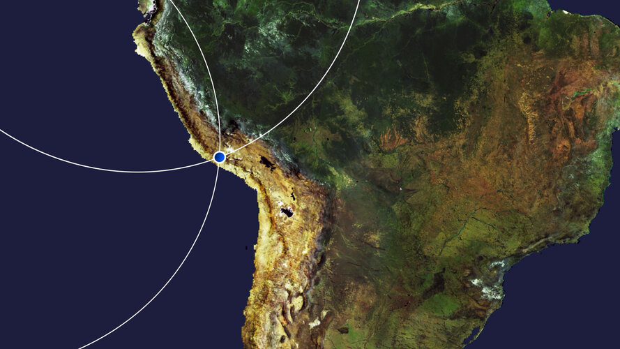 Video:
00:03:47
Video:
00:03:47
In this week's edition of the Earth from Space programme, the Andes mountains, in southern Peru, are featured in this false-colour image captured by the Copernicus Sentinel-2 mission
Peruvian Andes
26.6.2020 10:00 ESA Observing the Earth Image:
The Andes mountains, in southern Peru, are featured in this false-colour image captured by the Copernicus Sentinel-2 mission.
Image:
The Andes mountains, in southern Peru, are featured in this false-colour image captured by the Copernicus Sentinel-2 mission.
Earth from Space: Peruvian Andes
26.6.2020 10:00 ESA Observing the Earth Video:
00:03:47
Video:
00:03:47
In this week's edition of the Earth from Space programme, the Andes mountains, in southern Peru, are featured in this false-colour image captured by the Copernicus Sentinel-2 mission
HxGN Content Program updates 3 million square kilometres of aerial data in U.S., Europe in 2020
26.6.2020 9:00 GISCafe.com Webcasts-Webinars WASHINGTON, D.C., USA (23 June 2020) — Hexagon’s Geosystems division announced today the HxGN Content Program, the largest library of …Take part in citizen science for food security
26.6.2020 9:00 ESA Observing the Earth
The International Institute for Applied System Analysis (IIASA) and ESA, in partnership with the Wilson Center, the Earth Day Network and the US State Department, are giving citizens the opportunity to get involved in one of the world’s most challenging problems: ensuring a nutritious food supply to meet the needs of the growing global population.
Take part in citizen science for food security
26.6.2020 9:00 ESA Observing the Earth
The International Institute for Applied System Analysis (IIASA) and ESA, in partnership with the Wilson Center, the Earth Day Network and the US State Department, are giving citizens the opportunity to get involved in one of the world’s most challenging problems: ensuring a nutritious food supply to meet the needs of the growing global population.
1Spatial: Environment Agency Application Build and Managed Service Win
26.6.2020 9:00 GISCafe.com Webcasts-Webinars Cambridge, UK, 25th June 2020, (www.1spatial.com) 1Spatial, the global spatial software and solutions company is pleased to announce it has been …Mapy.cz na Slovensku v tichosti přecházejí na OSM data
26.6.2020 8:32 GISportal.cz
V záři novinek, jako je zobrazení intenzity dopravy v mobilní aplikaci, se bez větší pozornosti odehrává také změna, která pravděpodobně nepotěší uživatele ze Slovenska (nebo ty, co s mapami na Slovensko vyjíždějí). Z vlastních podrobných datových podkladů tu totiž populární mapový portál přechází na data z OpenStreetMap stejně jako u ostatních států. Jen při letmém […]
The post Mapy.cz na Slovensku v tichosti přecházejí na OSM data appeared first on GISportal.cz.
GIS v plánování měst a regionů 2020 (pozvánka)
26.6.2020 8:20 GISportal.cz
Česká asociace pro geoinformace (CAGI) a Vysoká škola regionální rozvoje a Bankovní institut – AMBIS, a.s. Vás srdečně zvou k účasti na 6. ročníku konference která se uskuteční v Praze v termínu 24. 9. 2020. Téma konference: Bezpečný a udržitelný turismus Tématické okruhy: Církevní památky jako fenomén cestovního ruchu Limity cestovního ruchu Téma pravidelného workshopu: Vyhodnocení zdravotního stavu stromů […]
The post GIS v plánování měst a regionů 2020 (pozvánka) appeared first on GISportal.cz.
Upozornění
26.6.2020 8:13 ČÚZK /Urady/Katastralni-urady/Katastralni-urady/Katastralni-urad-pro-Ustecky-kraj/Katastralni-pracoviste/KP-Decin/O-uradu/Aktuality/UpozorneniUpozornění
26.6.2020 8:13 ČÚZK - předpisy a opatření Katastrální úřad pro Ústecký kraj - Katastrální pracoviště Děčín zveřejnil novou aktualitu: UpozorněníVážení klienti,
Z důvodu přerušení dodávky elektrické energie bude dne 2.7.2020 od 8:00 do 11:00 Katastrální pracoviště Děčín uzavřeno pro veřejnost.
Děkujeme za pochopení
Ing. Ivo Apfelbeck, ředitel pracoviště
Zveřejnění obsahu informací poskytnutých na žádost dle zákona č. 106/1999 Sb. za rok 20
26.6.2020 6:39 ČÚZK /Urady/Zememericke-a-katastralni-inspektoraty/Zememericke-a-katastralni-inspektoraty/Zememericky-a-katastralni-inspektorat-v-Brne/Casto-hledane-informace/Poskytovani-informaci-106-1999-Sb/Zverejneni-obsahu-informaci-poskytnutych-na-za-(1)/Zverejneni-obsahu-informaci-poskytnutych-na-za-(4)Zveřejnění obsahu informací poskytnutých na žádost dle zákona č. 106/1999 Sb. za rok 20
26.6.2020 6:39 ČÚZK - předpisy a opatření Zeměměřický a katastrální inspektorát v Brnězveřejňuje obsah informace poskytnutých na žádost dle zákona č. 106/1999 Sb. za rok
2020
Katastrální mapa v rastrové podobě poskytovaná v e-shopu
26.6.2020 2:00 Cenia - Katalog metadat ČR - INSPIRE Katastrální mapa v rastrové podobě je poskytována za úplatu a obsahuje analogovou mapu s kompletní kresbou. Analogová mapa pokrývá 2,98 % území České republiky, což je 2 346,67km2. Více katastrální vyhláška č.357/2013 Sb. v platném znění.INSPIRE téma Parcely (CP)
26.6.2020 2:00 Cenia - Katalog metadat ČR - INSPIRE Data odpovídají směrnici INSPIRE pro téma katastrální parcely (CP). Vychází z katastrální mapy, která je závazným státním mapovým dílem velkého měřítka, obsahuje body polohového bodového pole, polohopis a popis a může mít formu digitální mapy, analogové mapy nebo digitalizované mapy. Data publikovaná v rámci INSPIRE obsahují pouze katastrální území (pro celou Českou Republiku) a parcely a jejich hranice z území, kde je digitální mapa (k 22. 06. 2020 je to 96,81% území České republiky, t.j. 76 350,93km2). Více katastrální zákon 344/1992 SB., katastrální vyhláška č.26/2007 Sb. v platném znění a INSPIRE Data Specification on Cadastral Parcels v 3.0.1. Data ve formátu GML 3.2.1 jsou validní proti schématu XML pro INSPIRE téma Parcely ve verzi 4.0 a proti schématu pro prostorová data ELF ve verzi 1.0.INSPIRE téma Rozšířené Parcely (CPX)
26.6.2020 2:00 Cenia - Katalog metadat ČR - INSPIRE Rozšíření má za cíl poskytovat katastrální mapu s obsahem podle vyhlášky ve vektorové podobě ve struktuře plně v souladu se strukturou danou směrnicí INSPIRE. Data rozšiřují směrnici INSPIRE pro téma katastrální parcely (CP) o věcná břemena, geodetické body, další prvky mapy, původní obloukovou geometrii a o parcely určené definičním bodem (ty pouze v oblastech s analogovou mapou). Vychází z katastrální mapy, která je závazným státním mapovým dílem velkého měřítka, obsahuje body polohového bodového pole, polohopis a popis a může mít formu digitální mapy, analogové mapy nebo digitalizované mapy. Publikovaná data obsahují katastrální území pro celou Českou Republiku, parcely a jejich hranice, věcná břemena, další prvky mapy a původní obloukovou geometrii z území, kde je digitální mapa (k 22. 06. 2020 je to 96,81% území České republiky, t.j. 76 350,93km2) a ve zbytku území katastrální parcely určené pouze definičním bodem (tedy bez hranic a polygonu). Katastrální parcely a hranice obsahují oproti datové sadě INSPIRE některé atributy navíc. Jedná se o typ hranice, způsob využití území, druh pozemku, vazbu na budovu a o mapové značky. Více katastrální zákon 344/1992 SB., katastrální vyhláška č.26/2007 Sb. v platném znění a INSPIRE Data Specification on Cadastral Parcels v 3.0.1. Data ve formátu GML 3.2.1 jsou validní proti schématu XML pro Rozšířené Parcely (CPX) ve verzi 4.0.INSPIRE téma Budovy (BU)
26.6.2020 2:00 Cenia - Katalog metadat ČR - INSPIRE Data odpovídají směrnici INSPIRE pro téma budovy (BU). Data pochází částečně z projektu RÚIAN (Registr územní identifikace, adres a nemovitostí), který je součástí základních registrů České Republiky a obsahuje informace o územní identifikaci, adresách a nemovitostech, a částečně z ISKN (Informační systém katastru nemovistostí). Zdrojem informací o budovách v ISKN je objekt Stavba, v RÚIAN je to Stavební objekt. Většina Staveb je zároveň Stavebními objekty, ale jsou případy, kdy tomu tak není. Kromě Budov datová sada obsahuje i části budov, které jsou pro potřeby INSPIRE vyjádřeny vchody z RÚIAN. Vchody obsahují informace o počtu podlaží, technickoekonomických atributech apod. Datová sada pokrývá celé území české republiky. V datové sadě není uvedeno 1,14%, t.j. 48357 budov (k 22. 06. 2020), protože neobsahují definiční bod ani polygon. Více v zákoně č. 111/2009 Sb., o základních registrech, ve vyhlášce č. 359/2011 Sb., o základním registru územní identifikace, adres a nemovitostí v platných zněních, v zákoně 256/2013 Sb., o katastru nemovitostí, v katastrální vyhlášce č. 357/2013 Sb. v platném znění a INSPIRE Data Specification on Buildings v 3.0 z 13.12.2013. Data ve formátu GML 3.2.1 jsou validní proti schématu XML pro INSPIRE téma Budovy ve verzi 4.0 a proti schématu pro prostorová data ELF ve verzi 1.0.INSPIRE téma Adresy (AD)
26.6.2020 2:00 Cenia - Katalog metadat ČR - INSPIRE Data odpovídají směrnici INSPIRE pro téma adresy (AD). Vychází především z projektu RÚIAN (Registr územní identifikace, adres a nemovitostí), který je součástí základních registrů České Republiky a obsahuje informace o územní identifikaci, adresách a nemovitostech. Data publikovaná v rámci INSPIRE obsahují pouze adresní místa a jejich komponenty, kterými jsou stát, obec, část obce, městský obvod v Praze (MOP), městký obvod/městská část (MO/MČ), ulice a pošta a to na území celé České Republiky. Obsahují rozvněž geometrii, která určuje definiční bod adresního místa. V datové sadě nění uvedeno 1,14%, t.j. 33472 adresních míst (k 22. 06. 2020), protože neobsahují definiční bod, podle kterého by je bylo možné prostorově určit. Více v zákoně č. 111/2009 Sb., o základních registrech a ve vyhlášce č. 359/2011 Sb., o základním registru územní identifikace, adres a nemovitostí v platných zněních a INSPIRE Data Specification on Addresses v 3.0.1 z 26.4.2010. Data ve formátu GML 3.2.1 jsou validní proti schématu XML pro INSPIRE téma Adresy ve verzi 4.0 a proti schématu pro prostorová data ELF ve verzi 1.0.Katastrální mapa ve formátech DGN a DXF poskytovaná v e-shopu
26.6.2020 2:00 Cenia - Katalog metadat ČR - INSPIRE Katastrální mapa je závazným státním mapovým dílem velkého měřítka, obsahuje body polohového bodového pole, polohopis a popis. Katastrální mapa ve vektorové podobě je poskytována zdarma ve formátu DGN a DXF a obsahuje prvky Digitální katastrální mapy (DKM) a Katastrální mapy digitalizované (KMD), tedy bodová pole, budovy, další prvky mapy, hranice parcel, katastrální hranice, parcely katastru nemovitostí, prvky orientační mapy a hranice věcného břemene. Z důvodu použití formátu DGN produkt neobsahuje značky na liniích a oblouky jsou nahrazeny lomenými čárami. Katastrální mapa ve vektorové podobě k 22. 06. 2020 pokrývá 96,81% území České republiky, t.j. 76 350,93km2. Více katastrální vyhláška č.357/2013 Sb. v platném znění.Airbus and ESA sign agreement to continue ISS operations
26.6.2020 0:44 GISCafe.com Webcasts-Webinars Comprehensive services contract for 2020, worth around €16 million, ensures operation and use of European ISS componentsResearch has been …ROK Technologies is the First Esri Silver Partner Awarded ArcGIS Cloud Services Specialty Designation
25.6.2020 23:49 GISCafe.com Webcasts-Webinars This designation is exclusively reserved for those who have expertise in deploying and managing ArcGIS in cloud environments; providing services for …Worldwide Services Market Growth Disrupted by Economic Impact of COVID-19, According to IDC
25.6.2020 20:43 GISCafe.com Webcasts-Webinars FRAMINGHAM, Mass. — (BUSINESS WIRE) — June 25, 2020 —In April, International Data Corporation (IDC) forecast worldwide IT …
Cartegraph Acquires PenBay Solutions, Combines Best-of-breed Infrastructure Management Tech
25.6.2020 20:43 GISCafe.com Webcasts-Webinars Esri Partners Join Forces to Help Organizations Seamlessly Manage Every Infrastructure Asset: Indoors, Outdoors, Above and Below GroundDUBUQUE, …
Concerns About Chinese Made Drones Could Drive the Commercial Drone Industry to New Heights
25.6.2020 20:43 GISCafe.com Webcasts-Webinars LOS ANGELES, June 25, 2020 — (PRNewswire) — USA News Group – U.S. government agencies have instituted policy bans on DJI and …Maxar Technologies Announces Exercise of Call Option to Acquire Vricon, Inc.
25.6.2020 20:43 GISCafe.com Webcasts-Webinars WESTMINSTER, Colo. — (BUSINESS WIRE) — June 25, 2020 —Maxar Technologies (NYSE:MAXR) (TSX:MAXR), a trusted partner and innovator …
Topcon Announces the European Launch of MYAH
25.6.2020 16:26 GISCafe.com Webcasts-Webinars Company Introduces Comprehensive Management Tool for Myopia and Dry EyeCAPELLE A/D IJSSEL, Netherlands — (BUSINESS WIRE) — June 24, 2020 …
National Geospatial-Intelligence Agency Signs CRADA with Capella Space
25.6.2020 16:26 GISCafe.com Webcasts-Webinars Capella Space becomes first U.S. commercial SAR satellite company to sign agreement with the NGA to support research effortsSAN FRANCISCO, June 25, …
Firefighters Support Alliance Launches Interactive Map, Tracking Economic Impact of Firefighters
25.6.2020 16:26 GISCafe.com Webcasts-Webinars ARLINGTON,Va., June 25, 2020 — (PRNewswire) — Firefighters Support Alliance has launched an initiative to help voters understand …Oznámení o plánované výluce telekomunikačních služeb dne 16.07.2020
25.6.2020 14:46 ČÚZK - předpisy a opatření Katastrální úřad pro Jihomoravský kraj - Katastrální pracoviště Znojmo zveřejnil novou aktualitu: Oznámení o plánované výluce telekomunikačních služeb dne 16.07.2020.Podrobnosti zde
Oznámení o plánované výluce telekomunikačních služeb dne 16.07.2020
25.6.2020 14:46 ČÚZK - předpisy a opatření Katastrální úřad pro Moravskoslezský kraj - Katastrální pracoviště Znojmo zveřejnil novou aktualitu: Oznámení o plánované výluce telekomunikačních služeb dne 16.07.2020.Podrobnosti zde
Space agencies join forces to produce global view of COVID-19 impacts
25.6.2020 14:00 ESA Observing the Earth
In an unprecedented collaboration, ESA, NASA and JAXA (Japan Aerospace Exploration Agency) have created a new tool that combines a wealth of data from Earth-observing satellites to monitor the worldwide impacts of COVID-19. This new online platform is now available to the public.
Na serverech ČÚZK dochází od 2
25.6.2020 12:59 GEUSware Na serverech ČÚZK dochází od 20.1.2020 postupně k vypínání protokolů TLS 1.0 a 1.1 a běží pouze protokol 1.2. Tato změna nemá vliv na aktuální verzi GEUS 24.0. V programu GEUS 23.0 a nižších verzích nyní přestaly fungovat funkce využívající data ze serveru services.cuzk.cz.Výstava: Dědictví zmizelých krajin Česka [Katedra aplikované geoinformatiky a kartografie, byTopic]
25.6.2020 11:25 Katedra aplikované geoinformatiky a kartografie Přf UK Srdečně Vás zveme na výstavu Dědictví zmizelých krajin Česka, která je k zhlédnutí od 22.6. do 31.8. 2020 v předsálí Mapové sbírky, Albertov 6, Praha 2. Výstava představuje výstupy projektu „Dědictví zaniklých krajin: identifikace, rekonstrukce a zpřístupnění“ vytvořené v letech 2018 a 2019. Vstup volný.Odstávka Geoportálu Jihočeského kraje
25.6.2020 7:35 Jihočeský kraj V pondělí 29.6.2020 bude prováděna údržba na serverových komponentách Geoportálu od 12:00 do večerních hodin. Během odstávky nebudou k dispozici evidenční a mapové aplikace a zároveň nebude možné vydávat prostřednictvím Geoportálu data. Děkujeme za pochopení.Odstávka Geoportálu Jihočeského kraje
25.6.2020 7:35 Jihočeský kraj V pondělí 29.6.2020 bude prováděna údržba na serverových komponentách Geoportálu od 12:00 do večerních hodin. Během odstávky nebudou k dispozici evidenční a mapové aplikace a zároveň nebude možné vydávat prostřednictvím Geoportálu data. Děkujeme za pochopení.Výluka telefonního spojení
25.6.2020 7:23 ČÚZK - předpisy a opatření Katastrální úřad pro Středočeský kraj - Katastrální pracoviště Příbram zveřejnil novou aktualitu: Dne 25. 6. 2020 nebude dostupné telefonické spojení s pracovištěm. Oprava telefonní ústředny. Za komplikace se omlouváme.Výluka telefonního spojení
25.6.2020 7:23 ČÚZK /Urady/Katastralni-urady/Katastralni-urady/Katastralni-urad-pro-Stredocesky-kraj/Katastralni-pracoviste/KP-Pribram/O-uradu/Aktuality/Vyluka-telefonniho-spojeni Ohlášený konec měsíčních pronájmů licencí Autodesk
Nefunkční telefony v budově ústředí
25.6.2020 0:00 Státní pozemkový úřad Praha, 25. června 2020: Upozornění! V budově ústředí v Husinecké ulici 1024/11a , Praha 3 - Žižkov jsou aktuálně zcela nefunkční telefony. Nelze volat ani přijímat hovory. Na odstranění poruchy pracuje telefonní operátor. Pro kontakt s pracovišti využijte e-mailové adresy pracovišť, jejich seznam naleznete zde: https://www.spucr.cz/kontakty/seznam-kontaktu. Velmi se omlouváme za případné problémy spojené s výpadkem telefonického spojení. Děkujeme za pochopení.Nefunkční telefony v budově ústředí
25.6.2020 0:00 Státní pozemkový úřad Praha, 25. června 2020: Upozornění! V budově ústředí v Husinecké ulici 1024/11a , Praha 3 - Žižkov jsou aktuálně zcela nefunkční telefony. Nelze volat ani přijímat hovory. Na odstranění poruchy pracuje telefonní operátor. Pro kontakt s pracovišti využijte e-mailové adresy pracovišť, jejich seznam naleznete zde: https://www.spucr.cz/kontakty/seznam-kontaktu. Velmi se omlouváme za případné problémy spojené s výpadkem telefonického spojení. Děkujeme za pochopení.Seequent launches contaminated site solution to aid environmental sustainability
24.6.2020 23:27 GISCafe.com Webcasts-Webinars CHRISTCHURCH, NZ, 23 June 2020 – Global geoscience software company Seequent has released a Contaminants extension for its 3D modelling and …L3Harris Technologies Wins Four NOAA Study Contracts for Future Satellite Constellation
24.6.2020 22:50 GISCafe.com Webcasts-Webinars Highlights:Uses high-performance solutions to deliver specific mission requirements
Provides a low-risk solution to meet NOAA’s future …
HERE Technologies promotes Stephen Patak to Senior Vice President and General Manager of the Americas region
24.6.2020 20:34 GISCafe.com Webcasts-Webinars June 24, 2020 Chicago, IL – HERE Technologies, a location data and platform company, today announced that Stephen Patak has been named Senior Vice …Kespry Announces Summer 2020 Aerial Intelligence Platform Release
24.6.2020 20:34 GISCafe.com Webcasts-Webinars Kespry drone analytics platform update delivers new Haul Roads feature, DJI Phantom 4 RTK integration, enhanced hail detection, and seamless …AgEagle Aerial Systems Announces Pricing of $7 Million Registered Direct Offering
24.6.2020 17:12 GISCafe.com Webcasts-Webinars NEODESHA, Kan., June 24, 2020 (GLOBE NEWSWIRE) -- AgEagle Aerial Systems Inc. (NYSE American: UAVS), an industry leading provider of unmanned …Omdia Index ranks HERE as top global location platform for enterprises
24.6.2020 15:22 GISCafe.com Webcasts-Webinars “HERE is once again in pole position, widening the gap with Google” - OmdiaMitsubishi Corporation and NTT’s investment in HERE highlight …Quantum Spatial Names Cherie Jarvis Director of eGIS Group
24.6.2020 15:22 GISCafe.com Webcasts-Webinars eGIS Team Manages Complex GIS Projects for Federal Government Clients, Leveraging Agile MethodologiesHOLLYWOOD, Fla., June 24, 2020 — …
Unacast Unveils Unacast Neighborhood Insights for Real Estate and Retail Industries
24.6.2020 15:22 GISCafe.com Webcasts-Webinars First of its kind tool provides actionable human mobility insights for business planning amid COVID-19 recoveryNEW YORK, June 24, 2020 — …
Woolpert to Provide Information Technology Archives and Information Management (AIM) Support Services for DOE Office of Legacy Management
24.6.2020 15:22 GISCafe.com Webcasts-Webinars The IDIQ contract will help the Legacy Management Support team deliver long-term sustainment of Department of Energy post-closure sites across the …Pozvánka na GIS Express 2020 on-line
24.6.2020 11:01 Geotronics GIS - Dovolujeme si Vás pozvat na říjnový GIS Express, letos netradičně on-line.Eos Positioning Systems Releases Eos Tools Pro for Windows
24.6.2020 9:00 GISCafe.com Webcasts-Webinars Eos’s new GNSS app for Windows 10 devices is loaded with new, powerful features and a colorful user interface. For developers, integrating …UPDATE: QGIS 3.14 Pí je ke stažení
24.6.2020 8:12 GISportal.cz
UPDATE: dodáno video s přehledem změn (viz níže). Oblíbeny open-source QGIS vychází v nové verzi a to QGIS 3.14 π (Pí). Tradiční changelog s popisem je dostupný na webu, nás však zaujala například možnost otvírání více atributových tabulek formou záložek.
The post UPDATE: QGIS 3.14 Pí je ke stažení appeared first on GISportal.cz.
QGIS 3.14 Pí je ke stažení
24.6.2020 8:12 GISportal.czOblíbeny open-source QGIS vychází v nové verzi a to QGIS 3.14 π (Pí). Tradiční changelog s popisem je dostupný na webu, nás však zaujala například možnost otvírání více atributových tabulek formou záložek.
The post QGIS 3.14 Pí je ke stažení appeared first on GISportal.cz.
USGIF Announces 11 New Board Members For 2020-2021
24.6.2020 2:26 GISCafe.com Webcasts-Webinars USGIF elects new members to its board of directors; including a new chairman of the boardHerndon, VA (June 23, 2020) --- The United States …
E-on Software Announces the Availability of its R5 Release for VUE, PlantFactory and PlantCatalog Solutions
24.6.2020 1:01 GISCafe.com Webcasts-Webinars e-on software's R5 release adds Machine-Learning-based interactive and offline path-tracing denoising, vastly improved displacement, SatMaps …Happy birthday Sentinel-2A: Five Years of Environmental Insights
24.6.2020 0:53 GISCafe.com Webcasts-Webinars Friedrichshafen, 23 June 2020 – Sentinel-2A has orbited Earth more than 26,000 times – and travelled nearly 1.2 billion kilometers in its …Maxar Technologies Announces its Intention to Acquire Vricon, Inc. to Accelerate Growth in Emerging Markets for 3D Technology and Extend its Lead in Earth Intelligence
24.6.2020 0:31 GISCafe.com Webcasts-Webinars WESTMINSTER, Colo. — (BUSINESS WIRE) — June 23, 2020 —Maxar Technologies (NYSE:MAXR) (TSX:MAXR), a trusted partner and innovator …
SkyWatch and AgIntegrated to Work Together to Bring Earth Observation Satellite Data to the Agriculture Industry
24.6.2020 0:31 GISCafe.com Webcasts-Webinars AgIntegrated's customers will now have access to satellite imagery ranging from 15m to 45cm resolution, thanks to a new integration with SkyWatch …Esri Named a Leader in Location Intelligence Platforms Report by Independent Market Research Firm
24.6.2020 0:31 GISCafe.com Webcasts-Webinars REDLANDS, Calif. — (BUSINESS WIRE) — June 23, 2020 —Esri, the global leader in GIS, location intelligence, and mapping …
SkyWatch and AgIntegrated to Work Together to Bring Earth Observation Satellite Data to the Agriculture Industry
23.6.2020 16:58 GISCafe.com Webcasts-Webinars June 23, 2020 -- With the ever-increasing need for remotely sensed imagery data in agriculture, SkyWatch Space Applications Inc. (SkyWatch) has …3D at Depth Launches Remote Sensing and Remote Data Control Technology
23.6.2020 16:30 GISCafe.com Webcasts-Webinars LONGMONT, Colo., June 23, 2020 (GLOBE NEWSWIRE) -- 3D at Depth Inc., the world’s leading expert in subsea laser (SL) LIDAR technology, survey …Unique collaboration releases updated official boundary and geospatial data for Europe
23.6.2020 16:30 GISCafe.com Webcasts-Webinars June 23, 2020 -- National Mapping, Cadastral and Land Registration authorities across Europe have provided official data for the latest seamless …SMOS monitoring droughts
23.6.2020 16:19 ESA Observing the Earth Video:
00:03:00
Video:
00:03:00
In orbit for more than a decade, ESA’s Earth Explorer satellite SMOS has not only exceeded its planned lifespan, but also surpassed its original scientific goals. Built to demonstrate new technology in space and address gaps in our scientific understanding of how Earth works as a system, this remarkable mission is now also being used for a number of practical applications. With drought seemingly more commonplace, entrepreneurs are using information on soil moisture from SMOS and data from other satellites to generate commercial data products for the insurance market, ultimately bringing benefits to farmers.
This video includes interviews of :
Klaus Scipal: SMOS Mission Manager, ESA, Soundbites in English & German
Thijs van Leeuwen: CEO of VanderSat – Soundbites in English & Dutch
Marcel Andriesse: Senior underwriter agri-culture Swiss Re - Soundbites in English & Dutch
rada/odborný rada – kontrola listin určených k záznamu
23.6.2020 15:35 ČÚZK - předpisy a opatření Katastrální úřad pro hlavní město Prahu - Katastrální pracoviště Prahavypisuje výběrové řízení na místo
rada/odborný rada – kontrola listin určených k záznamu