


![]()

zprávy
zdroje zpráv:20200409 Odborný referent oddělení právních vztahů k nemovitostem
9.4.2020 11:27 ČÚZK /Urady/Katastralni-urady/Katastralni-urady/Katastralni-urad-pro-Stredocesky-kraj/Katastralni-pracoviste/KP-Melnik/O-uradu/Aktuality/20190828-Odborny-rada-oddeleni-pravnich-vztahu-(5)20200409 Odborný referent oddělení právních vztahů k nemovitostem
9.4.2020 11:27 ČÚZK - předpisy a opatření Katastrální úřad pro Středočeský kraj - Katastrální pracoviště Mělník Vyhlášení výběrového řízení: Odborný referent oddělení právních vztahů k nemovitostem V části "Úřední deska", v sekci "Oznámení a jiná úřední sdělení" bylo vystaveno "Oznámení o vyhlášení výběrového řízení na obsazení služebního místa Odborný referent oddělení právních vztahů k nemovitostem"Odborný referent oddělení právních vztahů k nemovitostem
9.4.2020 11:26 ČÚZK - volná místa Katastrální úřad pro Středočeský kraj - Katastrální pracoviště Mělník vypisuje výběrové řízení na místo Odborný referent oddělení právních vztahů k nemovitostemOdborný referent oddělení právních vztahů k nemovitostem
9.4.2020 11:26 ČÚZK - předpisy a opatření Katastrální úřad pro Středočeský kraj - Katastrální pracoviště Mělníkvypisuje výběrové řízení na místo Odborný referent oddělení právních vztahů k nemovitostem
Odborný referent oddělení právních vztahů k nemovitostem
Odborný referent oddělení právních vztahů k nemovitostem
9.4.2020 11:26 ČÚZK /Urady/Katastralni-urady/Katastralni-urady/Katastralni-urad-pro-Stredocesky-kraj/Uredni-deska/Oznameni-a-jina-uredni-sdeleni/Volna-mista/Odborny-referent-oddeleni-pravnich-vztahu-k-ne-(2)Co přináší nová verze Map s příběhem?
9.4.2020 9:50 ARCDATAOd čtvrtka 9. dubna je k dispozici nová verze Map s příběhem, která s sebou přináší celou řadu dílčích vylepšení i úplně nových funkcí, které se vám v následujícím přehledu pokusíme krátce představit.
Navigační lišta příběhu
Vytvořením navigační lišty, nebo chcete-li „panelu záložek“, se ke všem blokům formátovaným jako nadpis automaticky vytvoří odkazy, jejichž prostřednictvím může čtenář přejít na konkrétní místo v příběhu.
Tuto funkci zapnete v panelu Návrh:

Z nadpisů se pak vytvoří navigační lišta.

Je-li panel záložek širší, než se vejde na obrazovku, lze se v něm posouvat pomocí šipek.

Maximum zobrazených nadpisů je 10. Pokud je název delší než 30 znaků, je automaticky zkrácen použitím výpustky „…“. Navigační lišta se zobrazuje stále nahoře, tedy i během rolování.
Vlastní úpravy navigační lišty
Lištu je dále možné upravovat. Zobrazit můžete například jen vybrané záložky (nadpisy), nebo upravit texty záložek. Tato nastavení můžete provést v nástrojích lišty na kartě Nastavení.

Nové možnosti bočního bloku: plovoucí panel
Při použití panelu „boční blok“ si můžete vybrat mezi dvěma typy zobrazení textové části: ukotveným a plovoucím, který se pohybuje zároveň s rolováním stránky.
Stejně jako do ukotveného verze, i do plovoucí je kromě textu možné přidávat i mapy, fotografie či jiný multimédiální obsah, oddělovače a tlačítka. Můžete si nastavit také jeho velikost a umístění.

Rozvržení bočního bloku snadno změníte v nastavení. Po změně panelu na ukotvenou verzi se tyto dílčí úpravy plovoucího bloku vrátí na výchozí nastavení.
Nová podoba sbírek
Sbírky (aktuálně v beta verzi) byly na základě zpětné vazby od autorů přepracovány. Úpravy se dotkly jak vlastního nástroje pro tvorbu sbírek, tak i stránky s přehledem sbírek. V náhledovém okně můžete zkontrolovat, jak budou vaše sbírky vypadat na počítači, telefonu či tabletu.

Na přehled sbírky se dostanete pomocí postranní lišty na úvodní stránce vpravo. Je na ní uveden název sbírky a položky, kterou si právě prohlížíte. Dále jsou k dispozici tlačítka, kterými se dostanete na předchozí či následující obrázek. Kliknutím na název sbírky se pak dostanete do jejího přehledu.

Duplikování expresních map v bočním bloku či prezentaci
V předchozí verzi bylo možné v bočním bloku či prezentaci duplikovat snímky, které obsahovaly obrázky, videa, webové mapy či scény. Nová verze podporuje i duplikování expresních map. Duplikovanou mapu je možné dále upravovat na panelu nástrojů v kartě úprav.
Zjednodušení tvorby expresních map
V editoru mapy se dá přepínat viditelnost různých vrstev mapy, uložit aktuální přiblížení a zobrazovanou oblast mapy. Tyto změny se vážou k aktuálnímu snímku. Pro úpravy zdrojové expresní mapy (jako je změna podkladové mapy, zákres nových prvků a podobně) použijte tlačítko Upravit mapu.

Nové motivy
Přibyly dva nové motivy: Tidal (modrý) a Slate (šedý). Přibyly také dvě dvojice fontů: Pax + Neue Swift a Ocean Sans + Mahsuri Sans.

V nových motivech jsou pro expresní mapy k dispozici tyto podkladové mapy:
Slate
- Newspaper (základní)
- Human geography dark (alternativní)
Tidal
- Ocean (základní)
- Streets dark (alternativní)
A pro oba ještě také družicové snímky.
Sjednocení nástrojů pro přidávání obrázků a videí
Nová verze sjednotila nástroje pro přidávání obrázků a videí. Soubor nyní můžete buď nahrát přímo z počítače, nebo jej vložit pomocí URL (kromě úvodního obrázku).

Skrytí snímku
Uživatelé mohou snímky nejen duplikovat, ale také skrývat, a to jak v bočním bloku, v prezentaci, tak i v prohlídce s průvodcem.

Skrytý snímek je automaticky přeskakován a při rolování stránkou se nezobrazuje. Skrytím snímku dojde také ke skrytí bodu na mapě, ke kterému snímek odkazoval. Další snímky v pořadí budou automaticky přečíslovány tak, aby na sebe navazovaly.
Vylepšené prohlídky s průvodcem
Do okna lze přidat video nebo obrázek pomocí URL.

Ke každému bodu mohou uživatelé i nadále přidat až 5 obrázků či videí. Jejich pořadí je možné měnit přímo v panelu médií.

Vylepšení se dočkaly také mapy
Uživatelé si mohou vybrat z následujících volitelných doplňků pro expresní či webové mapy a scény:
Vyhledávání

Lokalizace

Vypnutí mapové navigace (skryje tlačítka pro přibližování a posun mapy)

Nový vzhled anotací u expresních map
Panel nástrojů pro úpravu expresních map nabízí možnosti úprav vzhledu anotací a šipek.
Anotace a vodicí čáry

Jednosměrné a obousměrné šipky

Další vylepšení
- K vyhledávání map lze využít všechny kategorie z Living Atlas.
- Zlepšená podpora tisku složitějších bloků.
- Přechody mezi duplikovanými scénami používají stejnou animaci, jako se používá v Prohlížeči scén a v ArcGIS JavaScript API.
- Přetahovat myší se dají i bloky s tlačítky a s oddělovači.
Hromadné prodloužení výpůjček [Knihovna geografie, byTopic]
9.4.2020 9:50 Katedra aplikované geoinformatiky a kartografie Přf UK V souvislosti s prodloužením stavu nouze byly všechny výpůjčky opět prodlouženy, aktuální datum pro vrácení je do 15. 5. 2020.Maps-For-Free představují možnost zobrazení reliéfu po celém světě
9.4.2020 8:07 GISportal.cz
Německý projekt Maps-For-Free je jednoduchá prohlížečka mapových podkladů s relativně základními funkcemi. Co však stojí za pozornost je jejich zobrazení reliéfu celého světa. Pro tvorbu reliéfu používají datové sady USGS (geologická služba USA) a to konkrétně SRTM (Shuttle Radar Topography Mission) a GTOPO30. Mimo tyto vrstvy jsou k dispozici data z VMap0 od GIS.labu. Na mapě je také k […]
The post Maps-For-Free představují možnost zobrazení reliéfu po celém světě appeared first on GISportal.cz.
KGItalk online
9.4.2020 7:33 Katedra geoinformatiky UP OlomoucKGItalk bude pokračovat online ❗️ Díky aktuální situaci jsme se stali experty na online výuku 🖥 Proto padlo rozhodnutí, že od příští středy opět rozběhneme #kgitalk 🥳 Těšit se opět můžete na cestovatelské přednášky ale i na speciály představující, co se skrývá za aktuálními projekty chytré karantény, 3D tisku ochranných pomůcek nebo Corona vizualizací 🤓 […]
The post KGItalk online appeared first on Katedra geoinformatiky.
Pobočka Vyškov dokončila realizaci protierozního opatření v k.ú. Drnovice u Vyškova
9.4.2020 0:00 Státní pozemkový úřad Pobočka Vyškov během podzimu 2019 zabezpečila výsadbu krajinných prvků, sloužících především jako protierozní opatření nad zastavěnou částí obce Drnovice.Obec Drnovice se nachází asi 4 km západním směrem od obce Vyškov. Potřeba vybudovat zde tento prvek společných zařízení vzešla z návrhu komplexních pozemkových úprav (zapsaných do katastru nemovitostí v roce 2013) a z potřeby obce ochránit území před prvním přívalem vody z přilehlých polí, která leží na poměrně svažitých a dlouhých pozemcích. Protože se jedná o plochu v silně návětrném území, bude opatření sloužit také k ochraně před větrnou erozí.
Oh Man…
8.4.2020 23:13 Carlson Software Oh man, oh man, oh man…. Just what the heck is going on? Well, a few weeks ago I had all this stuff going on: getting ready to travel from one coast to another for conferences, preparing class presentations, renewing my passport just in case. Now, even though I’ve spent twice as much on groceries […]Map Into the Void
8.4.2020 23:05 Carlson Software For many mine sites around the world, the juxtaposition of a modern, open pit site with historic underground workings raises concerns of a potentially catastrophic hazard such as ground instability caused by the presence of old cavities underneath current mining operations. It is often the case that very little reliable mapping data survives from historic […]Esri Partners with MCH Strategic Data to Provide School Closure, Reopening, and Instructional Plan Data
8.4.2020 21:46 GISCafe.com Webcasts-Webinars Information on US Education Affected by COVID-19 Available on New DashboardREDLANDS, Calif. — (BUSINESS WIRE) — April 8, 2020 …
Kin Insurance Partners with Cape Analytics to Improve the Insurance Experience with Geospatial, Predictive Property Insights
8.4.2020 20:14 GISCafe.com Webcasts-Webinars MOUNTAIN VIEW, Calif. — (BUSINESS WIRE) — April 8, 2020 —Today, Cape Analytics is announcing that Kin Insurance – a fully …
Happy birthday to a cool satellite
8.4.2020 19:37 GISCafe.com Webcasts-Webinars Airbus-built CryoSat-2 gathering snow and ice data for a decade@AirbusSpace @esa_cryosat @ESA_EO #CryoSat #seaice
Friedrichshafen, 08 April 2020 …
20200408 - Negenerování změnových VFR
8.4.2020 19:35 ČÚZK /Uvod/Produkty-a-sluzby/RUIAN/2-Poskytovani-udaju-RUIAN-ISUI-VDP/Vymenny-format-RUIAN/Archiv-novinek-VFR/20200408-Negenerovani-zmenovych-VFR20200408 - Negenerování změnových VFR
8.4.2020 19:35 ČÚZK - předpisy a opatření Oznámení pro uživatele změnových VFR:Z technických důvodů bylo dočasně pozastaveno generování změnových VFR. V důsledku tohoto stavu bude do spuštění generování změnových VFR existovat nekonzistentní stav dat RÚIAN a VFR. O nápravě současného stavu vás budeme informovat. Omlouváme se za komplikace.
Zveřejněno 8. 4. 2020
20200408 - Negenerování změnových VFR
8.4.2020 19:35 ČÚZK - předpisy a opatření Oznámení pro uživatele změnových VFR:Z technických důvodů bylo dočasně pozastaveno generování změnových VFR. V důsledku tohoto stavu bude do spuštění generování změnových VFR existovat nekonzistentní stav dat RÚIAN a VFR. O nápravě současného stavu vás budeme informovat. Omlouváme se za komplikace.
Zveřejněno 8. 4. 2020
OGC members create new ‘OGC API - Styles’ Standards Working Group
8.4.2020 19:07 GISCafe.com Webcasts-Webinars Working Group aims to develop a new OGC API that will allow creators to publish and share styles to be used by different users, systems, and datasets …New Indoor Drone Uses UVC Lights for Disinfection of Essential Businesses
8.4.2020 17:55 GISCafe.com Webcasts-Webinars Digital Aerolus, the creators of the Aertos® drone are using its patented artificial intelligence (A.I.) system and mathematical framework for …HERE continues to lead as Counterpoint Research’s top location & mapping platform, ahead of Google and TomTom
8.4.2020 17:55 GISCafe.com Webcasts-Webinars Amsterdam – For the third time in a row, HERE Technologies was named by Counterpoint Research as the world’s number one location platform. The …New Indoor Drone Uses UVC Lights for Disinfection of Essential Businesses
8.4.2020 17:55 GISCafe.com Webcasts-Webinars Digital Aerolus, the creators of the Aertos® drone are using its patented artificial intelligence (A.I.) system and mathematical framework for …20200409 – volné místo – Ředitel/ka kanceláře ředitele katastrálního úřadu na KÚ pro Ústecký kraj
8.4.2020 13:47 ČÚZK - předpisy a opatření Katastrální úřad pro Ústecký kraj zveřejnil novou aktualitu: Nabídka volného pracovního místa - na služební místo představeného – Ředitel / ředitelka kanceláře ředitele katastrálního úřadu na Katastrálním úřadu pro Ústecký kraj20200409 – volné místo – Ředitel/ka kanceláře ředitele katastrálního úřadu na KÚ pro Ústecký kraj
8.4.2020 13:47 ČÚZK /Urady/Katastralni-urady/Katastralni-urady/Katastralni-urad-pro-Ustecky-kraj/O-uradu/Aktuality/20200409-–-volne-misto-–-Reditel-ka-kancelare-rediMaintaining EGNSS operations and security in challenging times: the GSA response
8.4.2020 12:34 European GNSS Agency
The coronavirus pandemic has had an impact on organisations, businesses, individuals and their families. As one of the few European Agencies delivering services 24/7, and with centres spread across Europe, the European GNSS Agency (GSA) has put various measures into place to ensure continuity of services and the security of EGNSS infrastructure, while at the same time prioritising the health and safety of staff and contractors.
The GSA is responsible for ensuring business continuity and keeping Galileo and EGNOS secure and operational, and this can only be done by protecting the health and safety of its staff and partners, which remains the Agency’s top priority.
The GSA is helped in this by the fact that, from its Prague headquarters, it is used to working remotely with the different Galileo and EGNOS sites across Europe. At the same time, special measures are being taken to protect the various operators working around the clock, seven days a week. The Agency is currently responding to the different scenarios in each country in order to manage security and operations, while putting measures in place to protect its people.
“These are very challenging times for all of us, requiring us to be flexible and resourceful. I am proud of how the GSA teams across our different sites have quickly adapted to the new situation,” said GSA Acting Executive Director Pascal Claudel. “The spirit of solidarity and cooperation I experience every day has shown me that the GSA’s team is its core asset and a strong foundation upon which to build the future of the Agency,” he said. “The entire European GNSS family has pulled together, and the GSA can rely on the support and commitment of all our partners, including Member States, industry, and SMEs.”
Read this: Are you aware? Beacons save lives!
GSA staff and contractors are learning new ways to work online to continue providing location, navigation and timing services to the user community. This applies equally at GSA headquarters and at the various sites. The Agency is also working with the European Commission, Member States and industry to find new solutions to emerging issues. “With the support of the Member States and industry, the GSA has demonstrated its leadership in this time of crisis, ensuring the continuity of the Galileo and EGNOS services. This is evidence that Europe is stronger together,” said GSA Administrative Board Chair Jean Yves Le Gall.
The GSA’s commitment to helping European industry benefit from EGNOS and Galileo remains as strong as ever, and the Agency is continuing its work on activities that are already underway.
Horizon 2020
The 21 ongoing projects remain on track (with the option of contractual adjustments to help partners impacted by the crisis). The new call with 44 project proposals is in the evaluation phase, for the first time taking place remotely via video conference.
Fundamental Elements
There are 19 projects ongoing and on track (also with contractual flexibility to help partners impacted by the crisis). For later in 2020, 13 more projects are already published or are under evaluation.
Industrial contracts
During the COVID-19 crisis, the GSA is ensuring full support to the EU space industry by agreeing contractual adjustments to be implemented as needed throughout the entire supply chain, from Primes to SMEs.
And this: eCall: 2 years of saving lives
GNSS and the response to COVID-19
Since the outbreak of the coronavirus earlier this year, many apps have been developed that use GNSS precise location to monitor the global spread of the virus and to map outbreaks of the COVID-19 disease. GNSS-apps are also proving their usefulness by helping people to implement social distancing in queues and other public spaces.
To support the EU response to COVID-19, the EC and GSA are also working on the “Galileo Green Lane” app, to facilitate the movement of goods and freight within the EU. The objective of the “Galileo Green Lane” is to relieve borders from the pressure of handling goods and to manage more efficiently the transit of critical goods. At the same time, this Galileo app will provide Member States with a tool to report to the EU on the Green Lanes initiative. A first version of the app is expected in mid-April.
The GSA is compiling a repository of these apps as a knowledge bank of solutions and toolbox that are being used to fight the pandemic and to help authorities, emergency response services, citizens and app developers to understand current needs and available resources.
If you have developed an app that is already working and being used to map the spread of the coronavirus, to monitor incidences of the disease, or to alert users about possible risky contacts, tell us about it and we will include it in our database. We are looking for apps that are already working and available. Submit some information on your solutions in writing to market@gsa.europa.eu and we will feature them on the GNSS4Crisis page.
Media note: This feature can be republished without charge provided the European GNSS Agency (GSA) is acknowledged as the source at the top or the bottom of the story. You must request permission before you use any of the photographs on the site. If you republish, we would be grateful if you could link back to the GSA website (http://www.gsa.europa.eu).
Maintaining EGNSS operations and security in challenging times: the GSA response
8.4.2020 12:34 European GNSS AgencyThe coronavirus pandemic has had an impact on organisations, businesses, individuals and their families. As one of the few European Agencies delivering services 24/7, and with centres spread across Europe, the European GNSS Agency (GSA) has put various measures into place to ensure continuity of services and the security of EGNSS infrastructure, while at the same time prioritising the health and safety of staff and contractors.
The GSA is responsible for ensuring business continuity and keeping Galileo and EGNOS secure and operational, and this can only be done by protecting the health and safety of its staff and partners, which remains the Agency’s top priority.
The GSA is helped in this by the fact that, from its Prague headquarters, it is used to working remotely with the different Galileo and EGNOS sites across Europe. At the same time, special measures are being taken to protect the various operators working around the clock, seven days a week. The Agency is currently responding to the different scenarios in each country in order to manage security and operations, while putting measures in place to protect its people.
“These are very challenging times for all of us, requiring us to be flexible and resourceful. I am proud of how the GSA teams across our different sites have quickly adapted to the new situation,” said GSA Acting Executive Director Pascal Claudel. “The spirit of solidarity and cooperation I experience every day has shown me that the GSA’s team is its core asset and a strong foundation upon which to build the future of the Agency,” he said. “The entire European GNSS family has pulled together, and the GSA can rely on the support and commitment of all our partners, including Member States, industry, and SMEs.”
Read this: Are you aware? Beacons save lives!
GSA staff and contractors are learning new ways to work online to continue providing location, navigation and timing services to the user community. This applies equally at GSA headquarters and at the various sites. The Agency is also working with the European Commission, Member States and industry to find new solutions to emerging issues. “With the support of the Member States and industry, the GSA has demonstrated its leadership in this time of crisis, ensuring the continuity of the Galileo and EGNOS services. This is evidence that Europe is stronger together,” said GSA Administrative Board Chair Jean Yves Le Gall.
The GSA’s commitment to helping European industry benefit from EGNOS and Galileo remains as strong as ever, and the Agency is continuing its work on activities that are already underway.
Horizon 2020
The 21 ongoing projects remain on track (with the option of contractual adjustments to help partners impacted by the crisis). The new call with 44 project proposals is in the evaluation phase, for the first time taking place remotely via video conference.
Fundamental Elements
There are 19 projects ongoing and on track (also with contractual flexibility to help partners impacted by the crisis). For later in 2020, 13 more projects are already published or are under evaluation.
Industrial contracts
During the COVID-19 crisis, the GSA is ensuring full support to the EU space industry by agreeing contractual adjustments to be implemented as needed throughout the entire supply chain, from Primes to SMEs.
And this: eCall: 2 years of saving lives
GNSS and the response to COVID-19
Since the outbreak of the coronavirus earlier this year, many apps have been developed that use GNSS precise location to monitor the global spread of the virus and to map outbreaks of the COVID-19 disease. GNSS-apps are also proving their usefulness by helping people to implement social distancing in queues and other public spaces.
To support the EU response to COVID-19, the EC and GSA are also working on the “Galileo Green Lane” app, to facilitate the movement of goods and freight within the EU. The objective of the “Galileo Green Lane” is to relieve borders from the pressure of handling goods and to manage more efficiently the transit of critical goods. At the same time, this Galileo app will provide Member States with a tool to report to the EU on the Green Lanes initiative. A first version of the app is expected in mid-April.
The GSA is compiling a repository of these apps as a knowledge bank of solutions and toolbox that are being used to fight the pandemic and to help authorities, emergency response services, citizens and app developers to understand current needs and available resources.
If you have developed an app that is already working and being used to map the spread of the coronavirus, to monitor incidences of the disease, or to alert users about possible risky contacts, tell us about it and we will include it in our database. We are looking for apps that are already working and available. Submit some information on your solutions in writing to market@gsa.europa.eu and we will feature them on the GNSS4Crisis page.
Media note: This feature can be republished without charge provided the European GNSS Agency (GSA) is acknowledged as the source at the top or the bottom of the story. You must request permission before you use any of the photographs on the site. If you republish, we would be grateful if you could link back to the GSA website (http://www.gsa.europa.eu).
Odborný referent – budování podrobných bodových polí v oddělení obnovy katastrálního operátu Katastr
8.4.2020 11:26 ČÚZK - předpisy a opatření Katastrální úřad pro Zlínský krajvypisuje výběrové řízení na místo
Odborný referent – budování podrobných bodových polí v oddělení obnovy katastrálního operátu Katastrálního úřadu pro Zlínský kraj
Odborný referent – budování podrobných bodových polí v oddělení obnovy katastrálního operátu Katastr
8.4.2020 11:26 ČÚZK - volná místa Katastrální úřad pro Zlínský kraj vypisuje výběrové řízení na místo Odborný referent – budování podrobných bodových polí v oddělení obnovy katastrálního operátu KatastrOdborný referent – budování podrobných bodových polí v oddělení obnovy katastrálního operátu Katastr
8.4.2020 11:26 ČÚZK /Urady/Katastralni-urady/Katastralni-urady/Katastralni-urad-pro-Zlinsky-kraj/Uredni-deska/Oznameni-a-jina-uredni-sdeleni/Volna-mista/DMS/Odborny-referent-–-budovani-podrobnych-bodovych-poCEEPUS ve 2020/2021
8.4.2020 11:04 Katedra geoinformatiky UP OlomoucBylo potvrzeno, že mobility skrz CEEPUS budou realizovány! V online platformě jsou dostupné informace výměnných pobytech a podrobnostech.
The post CEEPUS ve 2020/2021 appeared first on Katedra geoinformatiky.
CryoSat still cool at 10
8.4.2020 11:00 ESA Observing the Earth
Today marks 10 years since a Dnepr rocket blasted off from an underground silo in the remote desert steppe of Kazakhstan, launching one of ESA’s most remarkable Earth-observing satellites into orbit. Tucked safely within the rocket fairing, CryoSat had a tough job ahead: to measure variations in the height of Earth’s ice and reveal how climate change is affecting the polar regions. Carrying novel technology, this extraordinary mission has led to a wealth of scientific discoveries that go far beyond its primary objectives to measure polar ice. And, even at 10 years old, this incredible mission continues to surpass expectations.
Možnost brigády - anotování české lokalizace pro Natural Language Processing engine firmy D-Tag
8.4.2020 10:43 Blogující geomatici - FAV ZČU Švýcarská firma D-Tag Europe Ltd. poptává česky mluvící studenty pro překlad z ENG do CZE za 2000 HUF/hodinu (cca. 6EUR/hod).Popis nabídky:
"D-Tag Europe Ltd. is involved to deliver tasks for query building tasks of different language
contract with external experts who will act as individual consultants (also hereby known as
“Service Providers”) to deliver the tasks by the deadline.
- Translate and localize (using local expressions and language) master source queries
V případě zájmu kontaktujte prosím přímo paní Kinga Dancsházy na "kinga.dancshazy@ditag.eu" s předmětem emailu " CZ annotator student".
Možnost brigády - anotování české lokalizace pro Natural Language Processing engine firmy D-Tag
8.4.2020 10:43 Blogující geomatici - FAV ZČU Maďarská firma D-Tag Europe Ltd. poptává česky mluvící studenty pro překlad z ENG do CZE za 2000 HUF/hodinu (cca. 6EUR/hod).Popis nabídky:
"D-Tag Europe Ltd. is involved to deliver tasks for query building tasks of different language
contract with external experts who will act as individual consultants (also hereby known as
“Service Providers”) to deliver the tasks by the deadline.
- Translate and localize (using local expressions and language) master source queries
V případě zájmu kontaktujte prosím přímo paní Kinga Dancsházy na "kinga.dancshazy@ditag.eu" s předmětem emailu " CZ annotator student".
Zrušení setkání Český Těšín
8.4.2020 9:29 ČÚZK /Urady/Katastralni-urady/Katastralni-urady/Katastralni-urad-pro-Moravskoslezsky-kraj/Katastralni-pracoviste/KP-Karvina/O-uradu/Aktuality/Zruseni-setkani-Cesky-TesinZrušení setkání Český Těšín
8.4.2020 9:29 ČÚZK - předpisy a opatření Katastrální úřad pro Moravskoslezský kraj - Katastrální pracoviště Karviná zveřejnil novou aktualitu: Důležité upozornění!Setkání pracovníků Katastrálního pracoviště Karviná s vlastníky nemovitostí dotčených revizí údajů katastru nemovitostí v k. ú. Český Těšín, které se mělo konat ve velké zasedací místnosti v budově Městského úřadu Český Těšín dne 20. 4. 2020, se s ohledem na opatření přijatá vládou ČR v souvislosti s novým typem koronaviru Sars-CoV-2 ruší.
Druhý termín stanovený na 22. 6. 2020 zatím zůstává v platnosti.
Maxar Announces Close of MDA Divestiture and Provides Update on Ongoing Support of Critical Customer Missions
8.4.2020 9:00 GISCafe.com Webcasts-Webinars WESTMINSTER, Colo. — (BUSINESS WIRE) — April 8, 2020 —Maxar Technologies (NYSE:MAXR) (TSX:MAXR), a trusted partner and innovator …
Cenová mapa nemovitostí celé ČR – Atlas cen
8.4.2020 8:01 GISportal.cz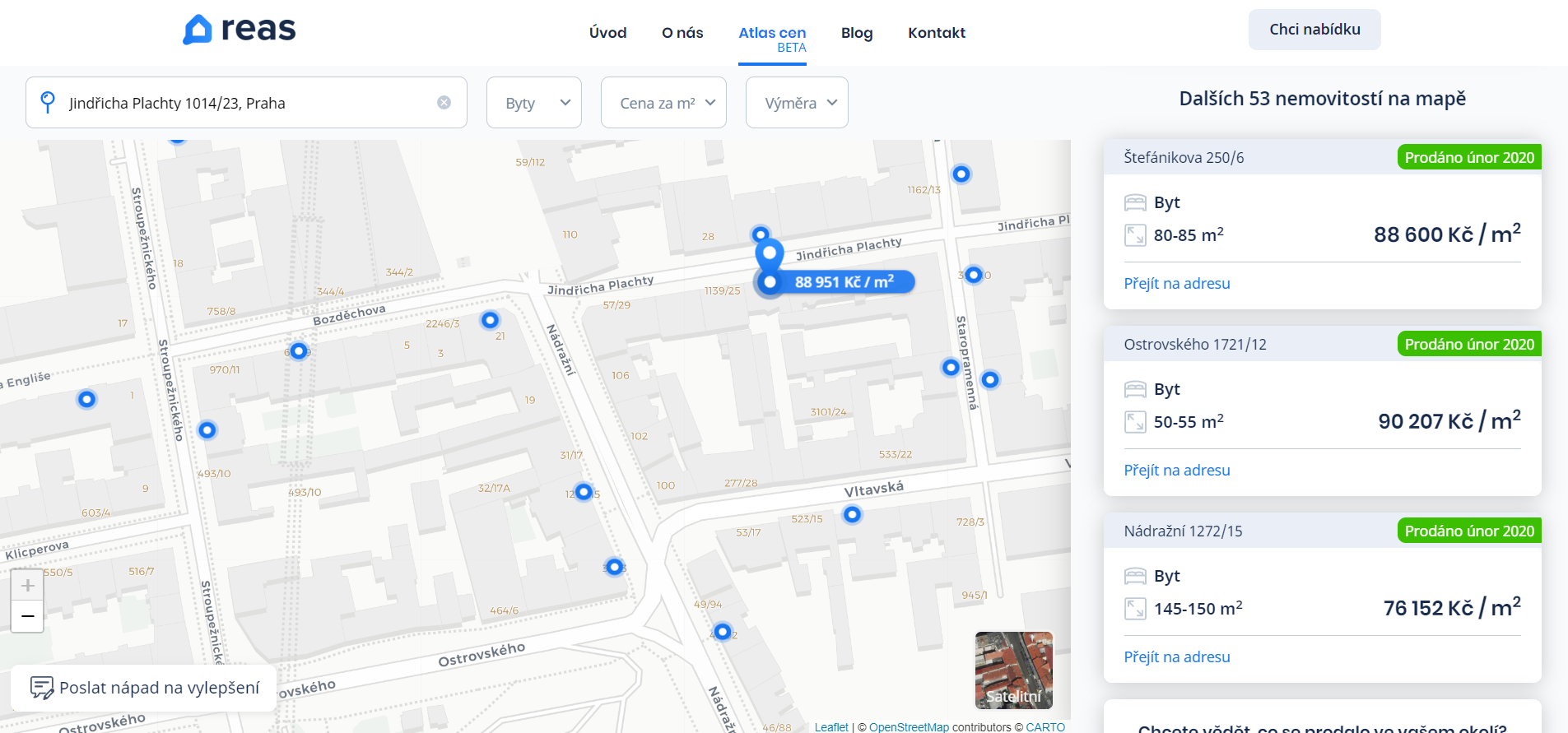
Před několika týdny se objevila první verze Atlasu cen, která ještě obsahovala reálné prodejní ceny, metráž jednotlivých bytů, apod., čímž podle Katastru nemovitostí porušil zákon – více o tom psali např. na CzechCrunch. Nová (7. 4. 2020) publikovaná verze Atlasu cen již obsahuje pouze ceny přepočtené na m2 a údaje o obytné ploše jsou rozděleny […]
The post Cenová mapa nemovitostí celé ČR – Atlas cen appeared first on GISportal.cz.
Esri and United Nations Team to Provide Countries with COVID-19 Data Resources
8.4.2020 2:11 GISCafe.com Webcasts-Webinars UN to Offer Free Access to Smart Mapping Software During Global PandemicREDLANDS, Calif. — (BUSINESS WIRE) — April 7, 2020 …
Quantum-Systems offers the MicaSense Dual Camera System for the Trinity F90+ fixed-wing UAV
7.4.2020 21:43 GISCafe.com Webcasts-Webinars 8th of April 2020: Gilching / Germany: As a manufacturer of advanced VTOL UAV systems for high-precision surveying tasks in the professional field it …Going Digital helped the Government of Malaysia leverage digital twins to deliver trusted information for better project and asset management
7.4.2020 18:58 Bentley SystemsPress Coverage
World Highways, UK
Read the articleDigital Twins in Utilities
7.4.2020 18:50 Bentley SystemsPress Coverage
PowerGrid Intl, USA
Read the articleCoreLogic Reports February Home Prices Increased by 4.1% Year Over Year
7.4.2020 18:37 GISCafe.com Webcasts-Webinars Annual home price increases in February 2020 reached their highest level in more than a yearAs of February 2020, and prior to the coronavirus …
ConnexiCore Is Supporting Construction Project Safety by Utilizing Drones for Social Distancing
7.4.2020 18:37 GISCafe.com Webcasts-Webinars Construction companies across the US are using drones to safely conduct inspections, gather data, and more, all while protecting workers.MILFORD, …
INDOT Selects Woolpert to Integrate UAS into Operations
7.4.2020 18:37 GISCafe.com Webcasts-Webinars Woolpert will work with INDOT officials to safely and effectively integrate UAS and related technologies into the business operations of multiple …Lemur Pro Esri-based GIS App from Critigen Now Available on SAP® App Center
7.4.2020 18:37 GISCafe.com Webcasts-Webinars Critigen delivers intuitive mobility solution to field workers by integrating Geographic Information System (GIS) with SAP® Asset Manager and SAP® …OMI Announces Drone Disinfection System for Large Indoor Spaces to Kill the Coronavirus
7.4.2020 18:37 GISCafe.com Webcasts-Webinars BELLE CHASSE, La., April 7, 2020 — (PRNewswire) — OMI Environmental Solutions, a K-Solv Group Company, announces Drone …Mikuláš Klaudyán v Dolním Bousově [Knihovna geografie, byTopic]
7.4.2020 18:35 Katedra aplikované geoinformatiky a kartografie Přf UK V období 17. 2. - 31. 3. 2020 byla výstava Mikuláš Klaudyán: první mapa Čech zapůjčena Infocentru Dolní Bousov.Why Utilities Need Digital Twins
7.4.2020 18:29 Bentley SystemsPress Coverage
PowerGrid Intl, USA
Read the articleHow Going Digital Can Reverse Your Engineering Challenges
7.4.2020 18:08 Bentley SystemsPress Coverage
Geo4Construction.com, France/Benelux
Read the articleNa Lupa.cz vyšel Jakubův článek o využití dronů po světě v probíhající pandemii
7.4.2020 10:33 UpVisionDnes vyšel Jakubův článek na Lupě, jak drony pomáhají po světě v probíhající pandemii a jak by mohli více pomoci i v České republice. Více zde: https://www.lupa.cz/clanky/od-sledovani-narusitelu-po-dopravu-leku-jak-se-pri-epidemii-vyuzivaji-drony/
The post Na Lupa.cz vyšel Jakubův článek o využití dronů po světě v probíhající pandemii appeared first on Upvision.
Na Lupa.cz vyšel Jakubův článek o využití dronů po světě v probíhající pandemii
7.4.2020 10:33 UpVisionDnes vyšel Jakubův článek na Lupě, jak drony pomáhají po světě v probíhající pandemii a jak by mohli více pomoci i v České republice. Více zde: https://www.lupa.cz/clanky/od-sledovani-narusitelu-po-dopravu-leku-jak-se-pri-epidemii-vyuzivaji-drony/
The post Na Lupa.cz vyšel Jakubův článek o využití dronů po světě v probíhající pandemii appeared first on Upvision.
Ministryně financí ČR ve Ville Hrdlička
7.4.2020 9:13 Hrdlička Město Česká Lípa pozvalo paní Schillerovou, která strávila celý den s představiteli města.3. díl služby UtilityReport je na světě
7.4.2020 9:12 Hrdlička V 3. díle Vám ukážeme, jaké náležitosti jsou potřeba při vyřízení žádosti o stavební povolení.Ministyně financí ČR ve Ville Hrdlička
7.4.2020 9:08 Hrdlička Město Česká Lípa pozvalo paní Schillerovou, která strávila celý den s představiteli města.Atlas rozvoje venkova
7.4.2020 7:00 Česká asociace pro geoinformace ATLAS Rozvoje venkovaBudoucnost venkova v České republice: Výzvy, vize, rozvojové scénáře a adaptační strategie
Před několika dny byl představen výsledek společného projektu TAČR pracovníků Západočeské univerzity v Plzni a Ostravské univerzity, který řeší přípravu českého venkova na budoucnost. Klíčovou pozornost věnuje otázkám ekonomického rozvoje a
INSPIRE Protected sites - other
7.4.2020 2:00 Cenia - Katalog metadat ČR - INSPIRE This data set contains spatial data for Buffer Zones of Specially Protected Areas. Buffer Zones of Specially Protected Areas are proclaimed in accordance with Section 37 of the Act No. 114/1992 Coll., on nature and landscape protection and preservation (Collection of Laws of the Czech Republic) to safeguard selected Specially Protected Areas in the Czech Republic against disturbing influences of the surroundings; © NCA CR (AOPK ČR), 2020ATOM INSPIRE Protected sites
7.4.2020 2:00 Cenia - Katalog metadat ČR - INSPIRE The download service provides spatial data for all protected sites according to the theme No. 9 mentioned in Annex I of the INSPIRE Directive (2007/2/EC) that are gathered by Nature Conservation Agency of the Czech Republic. Namely the service displays Natura 2000 sites, IUCN protected areas, UNESCO biosphere reserves, ramsar sites and other nationally protected areas (buffer zones of specially protected areas); © NCA CR (AOPK ČR), 2013 - 2020INSPIRE Protected sites - IUCN
7.4.2020 2:00 Cenia - Katalog metadat ČR - INSPIRE This data set contains spatial data for protected sites of the Czech Republic that match any of IUCN Protected Area Category. It includes both National Specially Protected Areas and Contract Protected Areas. The protected sites in this data set are divided into IUCN categories according to the INSPIRE registry codelist (http://inspire.ec.europa.eu/codelist/IUCNDesignationValue). Not all categories must be filled at a specific time; © NCA CR (AOPK ČR), 2020Iris Automation announces Casia 360, the first onboard detect-and-avoid system for drones with 360-degree capability
6.4.2020 17:48 GISCafe.com Webcasts-Webinars SAN FRANCISCO, April 6, 2020 — (PRNewswire) — Iris Automation today announced the launch of Casia 360 – the first onboard …Spatial Networks Announces Additional Funding from CIBC Innovation Banking
6.4.2020 17:48 GISCafe.com Webcasts-Webinars New Capital Brings 2020 Fundraising Total to $47M.ST. PETERSBURG, Fla., April 6, 2020 — (PRNewswire) —
ST. PETERSBURG, Fla., April 6, …
Maptycs Selected as Hot 100 InsureTech Company
6.4.2020 17:48 GISCafe.com Webcasts-Webinars Intelligent Insurer Names Maptycs as an InsurTech Company Making Tangible and Positive Difference in the Insurance IndustryNEW YORK, April 6, 2020 …
Woolpert Wins Google Cloud Location-Based Services Partner of the Year Award
6.4.2020 17:48 GISCafe.com Webcasts-Webinars Woolpert was recognized for the company's achievements in the Google Cloud ecosystem, helping joint customers deploy and optimize their …ANRA Technologies Launches SmartSkies Drone Airspace Authorization Platform for Airport Control Zones and Sensitive Areas
6.4.2020 17:48 GISCafe.com Webcasts-Webinars Building upon years of successful international experience, ANRA's best in class UTM software technology is ready to deploy at airports and sensitive …Podání učiněná formou sběrného boxu
6.4.2020 16:39 ČÚZK - předpisy a opatření Katastrální úřad pro Jihomoravský kraj - Katastrální pracoviště Znojmo zveřejnil novou aktualitu: Možnost bezkontaktního podáníPřestože jsou v souladu s usnesením vlády č. 399 ze dne 9.4. 2020 úřední hodiny pro veřejnost pouze v pondělí a středu od 8,00 do 17,00 hod., je možné i mimo tyto úřední hodiny vhodit podání v zalepené obálce do uzavřeného sběrného boxu, který je umístěn vždy u vstupu do budovy příslušného katastrálního pracoviště. Box je zpřístupněn v běžných úředních hodinách. Pokud bude v podání uvedena e-mailová adresa, bude na ní zasláno potvrzení o přijetí podání. Za okamžik podání návrhu na vklad se považuje okamžik výběru sběrného boxu. V případě, že je s podáním spojena poplatková povinnost, bude účastníkům zaslána i výzva k úhradě správního poplatku převodem na účet. Děkujeme, že budete v co největší míře využívat této zcela bezkontaktní možnosti.
Podrobnosti zde
Podání učiněná formou sběrného boxu
6.4.2020 16:39 ČÚZK - předpisy a opatření Katastrální úřad pro Jihomoravský kraj - Katastrální pracoviště Znojmo zveřejnil novou aktualitu: Podání učiněná formou sběrného boxuV úřední hodiny je možné do
uzavřeného boxu, který je
umístěn u vstupu do budovy
katastrálního pracoviště, vhodit
podání, nebo žádost o informace
z katastru nemovitostí.
Podrobnosti zde
Podání učiněná formou sběrného boxu
6.4.2020 16:39 ČÚZK - předpisy a opatření Katastrální úřad pro Jihomoravský kraj - Katastrální pracoviště Znojmo zveřejnil novou aktualitu: Možnost bezkontaktního podáníPřestože jsou v souladu s usnesením vlády č. 399 ze dne 9.4. 2020 úřední hodiny pro veřejnost pouze v pondělí a středu od 8,00 do 17,00 hod., je možné i mimo tyto úřední hodiny vhodit podání v zalepené obálce do uzavřeného sběrného boxu, který je umístěn vždy u vstupu do budovy příslušného katastrálního pracoviště. Box je zpřístupněn v běžných úředních hodinách. Pokud bude v podání uvedena e-mailová adresa, bude na ní zasláno potvrzení o přijetí podání. Za okamžik podání návrhu na vklad se považuje okamžik výběru sběrného boxu. V případě, že je s podáním spojena poplatková povinnost, bude účastníkům zaslána i výzva k úhradě správního poplatku převodem na účet. Děkujeme, že budete v co největší míře využívat této zcela bezkontaktní možnosti.
Podrobnosti zde
Podání učiněná formou sběrného boxu
6.4.2020 16:39 ČÚZK - předpisy a opatření Katastrální úřad pro Jihomoravský kraj - Katastrální pracoviště Znojmo zveřejnil novou aktualitu: Možnost bezkontaktního podáníPřestože jsou v souladu s usnesením vlády č. 399 ze dne 9.4. 2020 úřední hodiny pro veřejnost pouze v pondělí a středu od 8,00 do 17,00 hod., je možné i mimo tyto úřední hodiny vhodit podání v zalepené obálce do uzavřeného sběrného boxu, který je umístěn vždy u vstupu do budovy příslušného katastrálního pracoviště. Box je zpřístupněn v běžných úředních hodinách. Pokud bude v podání uvedena e-mailová adresa, bude na ní zasláno potvrzení o přijetí podání. Za okamžik podání návrhu na vklad se považuje okamžik výběru sběrného boxu. V případě, že je s podáním spojena poplatková povinnost, bude účastníkům zaslána i výzva k úhradě správního poplatku převodem na účet. Děkujeme, že budete v co největší míře využívat této zcela bezkontaktní možnosti.
Podrobnosti zde
Sběrný box - podrobnosti zde
Podání učiněná formou sběrného boxu
6.4.2020 16:39 ČÚZK - předpisy a opatření Katastrální úřad pro Jihomoravský kraj - Katastrální pracoviště Znojmo zveřejnil novou aktualitu: Možnost bezkontaktního podáníPřestože jsou v souladu s usnesením vlády č. 399 ze dne 9.4. 2020 úřední hodiny pro veřejnost pouze v pondělí a středu od 8,00 do 17,00 hod., je možné i mimo tyto úřední hodiny vhodit podání v zalepené obálce do uzavřeného sběrného boxu, který je umístěn vždy u vstupu do budovy příslušného katastrálního pracoviště. Box je zpřístupněn v běžných úředních hodinách. Pokud bude v podání uvedena e-mailová adresa, bude na ní zasláno potvrzení o přijetí podání. Za okamžik podání návrhu na vklad se považuje okamžik výběru sběrného boxu. V případě, že je s podáním spojena poplatková povinnost, bude účastníkům zaslána i výzva k úhradě správního poplatku převodem na účet. Děkujeme, že budete v co největší míře využívat této zcela bezkontaktní možnosti.
Podrobnosti zde
Podání učiněná formou sběrného boxu
6.4.2020 16:39 ČÚZK /Urady/Katastralni-urady/Katastralni-urady/Katastralni-urad-pro-Jihomoravsky-kraj/Katastralni-pracoviste/KP-Znojmo/O-uradu/Aktuality/Podani-ucinena-formou-sberneho-boxuPodání učiněná formou sběrného boxu
6.4.2020 16:39 ČÚZK - předpisy a opatření Katastrální úřad pro Jihomoravský kraj - Katastrální pracoviště Znojmo zveřejnil novou aktualitu: Možnost bezkontaktního podáníPřestože jsou v souladu s usnesením vlády č. 399 ze dne 9.4. 2020 úřední hodiny pro veřejnost pouze v pondělí a středu od 8,00 do 17,00 hod., je možné i mimo tyto úřední hodiny vhodit podání v zalepené obálce do uzavřeného sběrného boxu, který je umístěn vždy u vstupu do budovy příslušného katastrálního pracoviště. Box je zpřístupněn v běžných úředních hodinách. Pokud bude v podání uvedena e-mailová adresa, bude na ní zasláno potvrzení o přijetí podání. Za okamžik podání návrhu na vklad se považuje okamžik výběru sběrného boxu. V případě, že je s podáním spojena poplatková povinnost, bude účastníkům zaslána i výzva k úhradě správního poplatku převodem na účet. Děkujeme, že budete v co největší míře využívat této zcela bezkontaktní možnosti.
Podrobnosti zde
Podání učiněná formou sběrného boxu
6.4.2020 16:39 ČÚZK - předpisy a opatření Katastrální úřad pro Jihomoravský kraj - Katastrální pracoviště Znojmo zveřejnil novou aktualitu: Podání učiněná formousběrného boxu
V úřední hodiny je možné do
uzavřeného boxu, který je
umístěn u vstupu do budovy
katastrálního pracoviště, vhodit
podání, nebo žádost o informace
z katastru nemovitostí.
Podrobnosti zde
Oznámení o omezení provozu od 06.04.2020
6.4.2020 16:23 ČÚZK /Urady/Katastralni-urady/Katastralni-urady/Katastralni-urad-pro-Jihomoravsky-kraj/Katastralni-pracoviste/KP-Znojmo/Oznameni-o-omezeni-provozu-od-06-04-2020Oznámení o omezení provozu od 06.04.2020
6.4.2020 16:23 ČÚZK - předpisy a opatření Katastrální úřad pro Jihomoravský kraj - Katastrální pracoviště Znojmo zveřejnil novou aktualitu: Důležité upozornění 2V souladu s usnesením vlády ČR ze
dne 30.03.2020 č. 348 o vydání
mimořádných opatření Ministerstva
zdravotnictví a v souvislosti s vývojem
epidemiologické situace v okrese
Znojmo je od 06.04.2020 do odvolání
nahrazen osobní kontakt klientů
v budově katastrálního pracoviště
za možnost učinit podání
pouze formou sběrného boxu.
Děkujeme za pochopení.
Podrobnosti zde
Oznámení o omezení provozu od 06.04.2020
6.4.2020 16:23 ČÚZK - předpisy a opatření Katastrální úřad pro Jihomoravský kraj - Katastrální pracoviště Znojmo zveřejnil novou aktualitu: Důležité upozorněníV souladu s usnesením vlády ČR ze
dne 30.03.2020 č. 348 o vydání
mimořádných opatření Ministerstva
zdravotnictví a v souvislosti s vývojem
epidemiologické situace v okrese
Znojmo je od 06.04.2020 do odvolání
nahrazen osobní kontakt klientů
v budově katastrálního pracoviště
za možnost učinit podání
pouze formou sběrného boxu.
Děkujeme za pochopení.
Podrobnosti zde
Vrchní referent/rada – správce informačních a komunikačních technologií v oddělení podpory ICT techn
6.4.2020 13:14 ČÚZK /Urady/Katastralni-urady/Katastralni-urady/Katastralni-urad-pro-Kralovehradecky-kraj/Uredni-deska/Oznameni-a-jina-uredni-sdeleni/Volna-mista/Vrchni-referent-rada-–-spravce-informacnich-a-(1)Vrchní referent/rada – správce informačních a komunikačních technologií v oddělení podpory ICT techn
6.4.2020 13:14 ČÚZK - předpisy a opatření Katastrální úřad pro Královéhradecký krajvypisuje výběrové řízení na místo
Vrchní referent/rada – správce informačních a komunikačních technologií v oddělení podpory ICT technického útvaru Katastrálního úřadu pro Královéhradecký kraj
Vrchní referent/rada – správce informačních a komunikačních technologií v oddělení podpory ICT techn
6.4.2020 13:14 ČÚZK - volná místa Katastrální úřad pro Královéhradecký kraj vypisuje výběrové řízení na místo Vrchní referent/rada – správce informačních a komunikačních technologií v oddělení podpory ICT technAre you aware? Beacons save lives!
6.4.2020 12:11 European GNSS AgencyThe GNSS world marks Beacon Awareness Day (406 Day) on 6 April. But this celebration also has a more serious purpose - serving as a reminder to the owners of Search and Rescue 406MHz beacons to test them, check their batteries and update their Cospas-Sarsat or National Oceanic and Atmospheric Administration (NOAA) registration.
406 Day was started in 2013 by US beacon manufacturer ACR Electronics. Since then, the day has become an opportunity to raise public awareness of the benefits and responsibilities of owning 406 MHz beacons such as Emergency Position Indicating Radio Beacons (EPIRBs) and Personal Locator Beacons (PLBs). It is also an opportunity to let people know that beacons save lives, and to encourage people to #getabeacon.
“We can’t stress it enough – beacons save lives. If you work at sea, carrying a beacon with you will enable search and rescue services to find you quickly in an emergency – it can literally mean the difference between life and death,” said Manuel Lopez, Technology Officer at the European GNSS Agency (GSA).
Watch this: MEOSAR – Reaching you faster when every minute counts
If you already own a beacon, you can register it on the Cospas-Sarsat database. For contact details for beacon registration in your country, click here. To register your beacon with the U.S. National Oceanic and Atmospheric Administration (NOAA), click here.
Galileo helping to save lives
The GSA officially launched the Galileo's SAR service to coincide with 406 Day back in 2017, and this service has recently received a significant upgrade, with the launch earlier this year of the Galileo Return Link Service (RLS), which allows people in distress to receive automatic acknowledgement that their alert has been received and is being processed. The RLS, currently offered uniquely by Galileo, is a free-of-charge global service available to Cospas-Sarsat RLS compatible beacons.
The first performance evaluation of the Galileo RLS, published last month, showed excellent service provision that exceeded targets. The evaluation showed that the RLS was available 100% of the time, above the target value of 95%. On average, the system took 37 seconds to deliver automatic acknowledgement to the beacon, significantly better than the target value of 15 minutes. For more information, see the updated SAR/Galileo Service Definition Document.
Read this: Operation Shark Bait: Galileo SAR will save lives!
The Galileo SAR service, Europe’s contribution to the international satellite-based Cospas-Sarsat system, is comprised of two components: an automatic forward link distress alert and the RLS. This combination, along with the increased positioning accuracy provided by Galileo, has reduced the time it takes to detect a person lost at sea or in the mountains from three hours to just 10 minutes after the distress beacon is activated. Localisation of the distress beacon has also improved - from 10 km to less than 5 km.
To learn more of Galileo Search and Rescue service click here.
Media note: This feature can be republished without charge provided the European GNSS Agency (GSA) is acknowledged as the source at the top or the bottom of the story. You must request permission before you use any of the photographs on the site. If you republish, we would be grateful if you could link back to the GSA website (http://www.gsa.europa.eu).
Are you aware? Beacons save lives!
6.4.2020 12:11 European GNSS Agency 
Image:
Steering drones for power generation
Are you aware? Beacons save lives!
6.4.2020 12:11 European GNSS AgencyThe GNSS world marks Beacon Awareness Day (406 Day) on 6 April. But this celebration also has a more serious purpose - serving as a reminder to the owners of Search and Rescue 406MHz beacons to test them, check their batteries and update their Cospas-Sarsat or National Oceanic and Atmospheric Administration (NOAA) registration.
406 Day was started in 2013 by US beacon manufacturer ACR Electronics. Since then, the day has become an opportunity to raise public awareness of the benefits and responsibilities of owning 406 MHz beacons such as Emergency Position Indicating Radio Beacons (EPIRBs) and Personal Locator Beacons (PLBs). It is also an opportunity to let people know that beacons save lives, and to encourage people to #getabeacon.
“We can’t stress it enough – beacons save lives. If you work at sea, carrying a beacon with you will enable search and rescue services to find you quickly in an emergency – it can literally mean the difference between life and death,” said Manuel Lopez, Technology Officer at the European GNSS Agency (GSA).
Watch this: MEOSAR – Reaching you faster when every minute counts
If you already own a beacon, you can register it on the Cospas-Sarsat database. For contact details for beacon registration in your country, click here. To register your beacon with the U.S. National Oceanic and Atmospheric Administration (NOAA), click here.
Galileo helping to save lives
The GSA officially launched the Galileo's SAR service to coincide with 406 Day back in 2017, and this service has recently received a significant upgrade, with the launch earlier this year of the Galileo Return Link Service (RLS), which allows people in distress to receive automatic acknowledgement that their alert has been received and is being processed. The RLS, currently offered uniquely by Galileo, is a free-of-charge global service available to Cospas-Sarsat RLS compatible beacons.
The first performance evaluation of the Galileo RLS, published last month, showed excellent service provision that exceeded targets. The evaluation showed that the RLS was available 100% of the time, above the target value of 95%. On average, the system took 37 seconds to deliver automatic acknowledgement to the beacon, significantly better than the target value of 15 minutes. For more information, see the updated SAR/Galileo Service Definition Document.
Read this: Operation Shark Bait: Galileo SAR will save lives!
The Galileo SAR service, Europe’s contribution to the international satellite-based Cospas-Sarsat system, is comprised of two components: an automatic forward link distress alert and the RLS. This combination, along with the increased positioning accuracy provided by Galileo, has reduced the time it takes to detect a person lost at sea or in the mountains from three hours to just 10 minutes after the distress beacon is activated. Localisation of the distress beacon has also improved - from 10 km to less than 5 km.
To learn more of Galileo Search and Rescue service click here.
Media note: This feature can be republished without charge provided the European GNSS Agency (GSA) is acknowledged as the source at the top or the bottom of the story. You must request permission before you use any of the photographs on the site. If you republish, we would be grateful if you could link back to the GSA website (http://www.gsa.europa.eu).
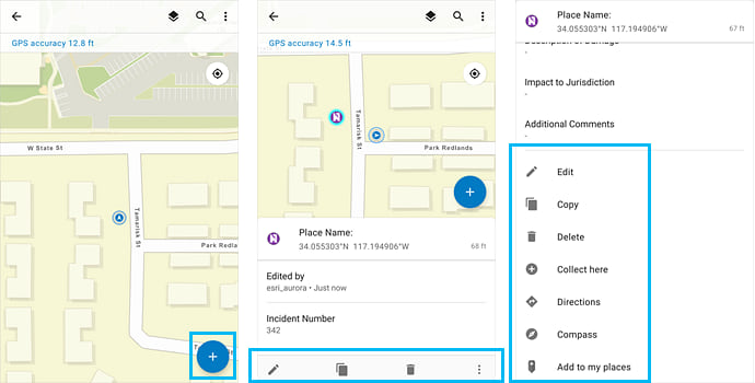
Nový Collector for ArcGIS pro Android
6.4.2020 11:29 ARCDATANová generace aplikace Collector for ArcGIS pro Android přešla z beta verze do oficiálního vydání. Proti své předchozí verzi přináší podporu nových webových map, upravené uživatelské prostředí, vylepšenou editaci formulářů, usnadnění offline práce, nové nástroje a podporu pro sběr 3D dat.
Podpora nových webových map
Collector for ArcGIS umí pracovat s vektorovými podkladovými mapami, což ocení zejména uživatelé s tablety a telefony s vysokým rozlišením. Znamená to také, že s mapou lze např. otáčet. Aplikace také umí pracovat se složitější symbolikou včetně grafických efektů a dokáže zobrazovat i popisky vytvořené pomocí jazyka Arcade.
Uživatelské prostředí
Na základě návrhů od uživatelů starší verze byly přepracovány některé části aplikace. Při editaci atributů prvku se využívá vysouvacího panelu a mapa tak může být stále viditelná. Upraveno je také samotné zadávání bodu – nový zaměřovací kříž umožní lépe určit přesnou polohu sbíraného prvku. Zrychlil se i přístup ke kameře a uživatelé ocení novou nástrojovou lištu.
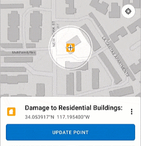
Usnadnění offline práce
Collector dokáže pracovat nejen s jednou offline oblastí (podobně jako jeho předchůdce), ale také existuje možnost vytvořit několik offline oblastí v jedné webové mapě a uživatelé si mohou stáhnout pouze některé z nich. Synchronizaci je možné provádět přímo z prostředí mapy.
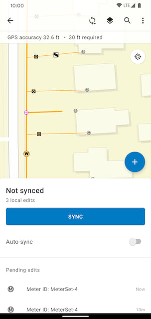
Nové nástroje
V aplikaci lze zobrazit legendu mapy. Nástroj Compass pomůže uživateli s navigací k prvku, který je poblíž, a nástroj Directions mu k němu najde cestu prostřednictvím Google Maps nebo Navigator for ArcGIS.
Sběr 3D dat
Nový Collector for ArcGIS podporuje sběr souřadnice z z GPS přijímačů, včetně možnosti úpravy o parametr MSL.
Přechod mezi aplikacemi
Stará verze aplikace Collector se v obchodě Google Play přejmenovala na Collector Classic a je možné mít obě aplikace v zařízení nainstalované najednou. Postupný přechod z jedné aplikace na druhou by tak pro pracovníky neměl být problém.

Stanovisko KPÚ SR
6.4.2020 11:07 Komora pozemkových úprav SR
Stanovisko KPÚ SR k situácii v akej sa nachádza usporiadanie pozemkového vlastníctva pomocou pozemkových úprav v SR
Půjčování knih diplomantům a bakalariantům od 6. 4. 2020 [Knihovna geografie, byTopic]
6.4.2020 10:35 Katedra aplikované geoinformatiky a kartografie Přf UKPůjčování knih diplomantům a bakalariantům od 6. 4. 2020 [Knihovna geografie, byTopic]
6.4.2020 10:35 Katedra aplikované geoinformatiky a kartografie Přf UK Z důvodu preventivních opatření v souvislosti s šířením onemocnění novým typem coronaviru COVID-19 bylo rozhodnuto o uzavření Knihovny geografie od 11. 3. 2020 do odvolání. Knihovna však může vypůjčit diplomantům a bakalariantům tituly potřebné k jejich práci po předchozí komunikaci e-mailem v domluveném termínu.Půjčování knih diplomantům a bakalariantům od 6. 4. 2020 [Knihovna geografie, byTopic]
6.4.2020 10:35 Katedra aplikované geoinformatiky a kartografie Přf UK Knihovna může vypůjčit diplomantům a bakalariantům tituly potřebné k jejich práci po předchozí komunikaci e-mailem v domluveném termínu.Unusual ozone hole opens over the Arctic
6.4.2020 9:40 ESA Observing the Earth
Scientists using data from the Copernicus Sentinel-5P satellite have noticed a strong reduction of ozone concentrations over the Arctic. Unusual atmospheric conditions, including freezing temperatures in the stratosphere, have led ozone levels to plummet – causing a ‘mini-hole’ in the ozone layer.
Unusual ozone hole opens over the Arctic
6.4.2020 9:40 ESA Observing the Earth
Scientists using data from the Copernicus Sentinel-5P satellite have noticed a strong reduction of ozone concentrations over the Arctic. Unusual atmospheric conditions, including freezing temperatures in the stratosphere, have led ozone levels to plummet – causing a ‘mini-hole’ in the ozone layer.
Nefunkční telefonické spojení
6.4.2020 8:46 ČÚZK - předpisy a opatření Katastrální úřad pro Moravskoslezský kraj - Katastrální pracoviště Ostravazveřejnil novou aktualitu: Na KP Ostrava není v současné době plně funkční telefonické spojení. Na vyřešení tohoto problému pracujeme.
Nefunkční telefonické spojení
6.4.2020 8:46 ČÚZK /Urady/Katastralni-urady/Katastralni-urady/Katastralni-urad-pro-Moravskoslezsky-kraj/Katastralni-pracoviste/KP-Ostrava/O-uradu/Aktuality/Nefunkcni-telefonicke-spojeniOznámení o omezení provozu od 06.04.2020
5.4.2020 17:10 ČÚZK - předpisy a opatření Katastrální úřad pro Jihomoravský kraj - Katastrální pracoviště Znojmo zveřejnil novou aktualitu: Úřední hodiny pouze formou sběrného boxuPodrobnosti zde
Oznámení o omezení provozu od 06.04.2020
5.4.2020 17:10 ČÚZK - předpisy a opatření Katastrální úřad pro Jihomoravský kraj - Katastrální pracoviště Znojmo zveřejnil novou aktualitu: Úřední hodiny pouze formou sběrného boxu.Podrobnosti zde
Oznámení o omezení provozu od 06.04.2020
5.4.2020 17:10 ČÚZK - předpisy a opatření Katastrální úřad pro Jihomoravský kraj - Katastrální pracoviště Znojmo zveřejnil novou aktualitu: Úřední doba se po dobu mimořádných opatření mění na pondělí a středu od 8 - 11 hodinPodrobnosti zde
Oznámení o omezení provozu od 06.04.2020
5.4.2020 17:10 ČÚZK - předpisy a opatření Katastrální úřad pro Jihomoravský kraj - Katastrální pracoviště Znojmo zveřejnil novou aktualitu: Důležité upozorněníV souladu s usnesením vlády ČR ze
dne 30.03.2020 č. 348 o vydání
mimořádných opatření Ministerstva
zdravotnictví a v souvislosti s vývojem
epidemiologické situace v okrese
Znojmo je od 06.04.2020 do odvolání
nahrazen osobní kontakt klientů
v budově katastrálního pracoviště
za možnost učinit podání
pouze formou sběrného boxu.
Děkujeme za pochopení.
Podrobnosti zde
Oznámení o omezení provozu od 06.04.2020
5.4.2020 17:10 ČÚZK /Urady/Katastralni-urady/Katastralni-urady/Katastralni-urad-pro-Jihomoravsky-kraj/Katastralni-pracoviste/KP-Znojmo/O-uradu/Aktuality/Oznameni-o-omezeni-provozu-od-06-04-2020Oznámení o omezení provozu od 06.04.2020
5.4.2020 17:10 ČÚZK - předpisy a opatření Katastrální úřad pro Jihomoravský kraj - Katastrální pracoviště Znojmo zveřejnil novou aktualitu: Důležité upozorněníV souladu s usnesením vlády ČR
ze dne 30.03.2020 č. 348 o vydání
mimořádných opatření Ministerstva
zdravotnictví a v souvislosti
s vývojem epidemiologické situace
v okrese Znojmo je od 06.04.2020
do odvolání nahrazen osobní
kontakt klientů v budově
katastrálního pracoviště za
možnost učinit podání
pouze formou sběrného boxu.
Děkujeme za pochopení.
Podrobnosti zde
Oznámení o omezení provozu od 06.04.2020
5.4.2020 17:10 ČÚZK - předpisy a opatření Katastrální úřad pro Jihomoravský kraj - Katastrální pracoviště Znojmo zveřejnil novou aktualitu: Důležité upozorněníV souladu s usnesením vlády ČR ze
dne 30.03.2020 č. 348 o vydání
mimořádných opatření Ministerstva
zdravotnictví a v souvislosti s vývojem
epidemiologické situace v okrese
Znojmo je od 06.04.2020 do odvolání
nahrazen osobní kontakt klientů
v budově katastrálního pracoviště
za možnost učinit podání
pouze formou sběrného boxu.
Děkujeme za pochopení.
Podrobnosti zde
Nezastaví vás ani koronavirus
5.4.2020 14:22 GEPROPřipravili jsme pro vás nové verze 14.52 našich produktů, které používáte nejčastěji. Stahovat je můžete z obvyklého umístění na našem download serveru.… >>
Nezastaví vás ani koronavirus
5.4.2020 14:22 GEPROPřipravili jsme pro vás nové verze 14.52 našich produktů, které používáte nejčastěji..
Stahovat je můžete z obvyklého umístění na našem download serveru.… >>
Čisté tržby Hexagonu meziročně rostly o 4 procenta
4.4.2020 11:07 GeoBusinessŠvédský koncern Hexagon, pod jehož křídla spadá například Leica Geosystems nebo Melown Technologies, publikoval počátkem dubna své hospodářské výsledky ve výroční zprávě za rok 2019. Hexagon zaměstnává přibližně 21 000 zaměstnanců v 50 zemích světa. Net sales increased by 4 per cent to 3,907.7 MEUR (3,760.7). Using fixed exchange rates and a comparable group structure […]
The post Čisté tržby Hexagonu meziročně rostly o 4 procenta appeared first on GeoBusiness.
New Coronavirus Risk Assessment Toolkit Released to the Public
4.4.2020 3:19 GISCafe.com Webcasts-Webinars BestPlaces.net, a small firm in Portland Oregon, has released several data sets to help health professionals and policy makers gain insights into how …Woolpert, Esri Develop Free Airport FEMA Reimbursement Application
4.4.2020 3:19 GISCafe.com Webcasts-Webinars The application will help airports submit forms to expedite FEMA reimbursements.DAYTON, Ohio, April 3, 2020 — (PRNewswire) —
DAYTON, …
A North American Coronavirus Map Reminds Us Why To #StayHome
3.4.2020 21:34 GISCafe.com Webcasts-Webinars CartoVista shares an informative coronavirus map of North America to inform people on the effects of COVID-19 at the local levelCanada's cases of …
Say hello – wave goodbye to BepiColombo
3.4.2020 19:50 GISCafe.com Webcasts-Webinars 03 April 2020 – The Airbus built BepiColombo mission will make a fly-by past Earth on 10th April 2020 as it continues on its epic journey to …Hexagon Publishes the Annual Report and Sustainability Report 2019
3.4.2020 17:35 GISCafe.com Webcasts-Webinars NACKA STRAND, Sweden, April 3, 2020 — (PRNewswire) — Hexagon's Annual Report 2019 and separate Sustainability Report is now available at …The National Self-Reporting System is Live: Residents Can Now Help First Responders be Better Prepared by Reporting COVID-19 & High-Risk Occupant Information in Minutes
3.4.2020 17:35 GISCafe.com Webcasts-Webinars Community Connect bridges the data and communication gap between First Responders and the communities they serve by allowing residents to create …Dedrone Welcomes Aaditya Devarakonda as President & Chief Business Officer
3.4.2020 17:34 GISCafe.com Webcasts-Webinars Devarakonda to oversee global sales, business development and product to scale the organization amidst a rapidly evolving counter-drone technology …How JPW is using Bentley’s OpenBuildings Designer GenerativeComponents to Push the Edge of Practice with Technology
3.4.2020 17:23 Bentley SystemsPress Coverage
Architosh, USA
Read the articleIntroducing 90-day Carlson Software Subscription Options
3.4.2020 17:23 Carlson Software Carlson Software has announced a new option to help ease the transition to working remotely. The COVID-19 situation has necessitated remote working for many across the world, and in response, Carlson is now offering 90-day software licenses on our most popular software. This 90-day subscription option for Carlson’s office software includes Survey, Civil, GIS, CADnet, […]Introducing a Deferred Payment Option on Carlson Hardware and Software
3.4.2020 17:23 Carlson Software Carlson Software has announced a new option to help ease the economic uncertainty introduced by the COVID-19 situation. Carlson is now offering low-rate financing plans including 90-day deferred payments for purchases of software and hardware. Any combination of Carlson products equaling at least $4,000 is eligible for the program, which offers flexible repayment options after […]4D Construction Planning Saves Tideway East GBP 1 Million on UK’s Largest-ever Water Infrastructure Project
3.4.2020 17:17 Bentley SystemsPress Coverage
Geo4Construction.com, France/Benelux
Read the articleBentley ups the ante on BIM CDEs, acquires UK’s GroupBC
3.4.2020 17:00 Bentley SystemsPress Coverage
Schnitger Group, USA
Read the articleWorking With Cloud Data and Surfaces
3.4.2020 16:53 Carlson Software Everyone who has worked with a drone or scanner has come to realize the difficulties that are often presented with that method of mapping. The final output, beyond just an image file, usually comes in the form of a point cloud, a LAS or a similar format. These clouds contain a tremendous amount of data […]KORONAVIRUS - Aktuální informace
3.4.2020 14:00 Středočeský kraj Interaktivní mapa KORONAVIRUS - Odběrová místa a zásobování ochranných pomůcek ve Středočeském kraji byla přejmenována na KORONAVIRUS - Aktuální informace. Do interaktivní mapy byly přidány dvě nové vrstvy. První vrstva zobrazuje Sociální služby Středočeského kraje. Jedná se o 60 subjektů (převážně o domovy seniorů), které jsou ve správě Středočeského kraje. Druhou vrstvou je Výskyt potvrzených případů. Jedná se o sdílenou službu, kterou pravidelně aktualizuje Krajská hygienická stanice Středočeského kraje, ZDE. Vrstva Zásobování ochranných pomůcek byla dočasně odstraněna z důvodu neaktuálních zdrojových dat.osobní automobil ŠKODA FABIA COMBI
3.4.2020 13:49 ČÚZK - předpisy a opatřeníKatastrální úřad pro Vysočinu nabízí nepotřebný majetek k odkupu. Jedná se o
osobní automobil ŠKODA FABIA COMBI
osobní automobil ŠKODA FABIA COMBI
3.4.2020 13:49 ČÚZK /Urady/Katastralni-urady/Katastralni-urady/Katastralni-urad-pro-Vysocinu/Nabidky-majetku/osobni-automobil-SKODA-FABIA-COMBI-(1)Rada / odborný rada – vedoucí ekonomicko – správního oddělení Kanceláře ředitele Katastrálního úřadu
3.4.2020 11:44 ČÚZK - předpisy a opatření Katastrální úřad pro Zlínský kraj kancelář ředitelevypisuje výběrové řízení na místo
Rada / odborný rada – vedoucí ekonomicko – správního oddělení Kanceláře ředitele Katastrálního úřadu pro Zlínský kraj