


![]()

zprávy
zdroje zpráv:Results of OGC’s biggest Innovation Initiative in 2019, Testbed-15, are now available
1.4.2020 19:54 GISCafe.com Webcasts-Webinars The latest advances in Geospatial Data Processing, Analysis, and Visualization have been documented in Testbed-15’s Sixteen Engineering …NEARMAP TO PROVIDE FREE HIGH-RESOLUTION AERIAL IMAGERY TO HEALTH OFFICIALS AND GOVERNMENT AGENCIES FOR COVID-19 RELIEF EFFORTS
1.4.2020 17:31 GISCafe.com Webcasts-Webinars SALT LAKE CITY, April 01, 2020 (GLOBE NEWSWIRE) -- Leading aerial imagery company Nearmap announced today that it is making its high-resolution …Nearmap to provide free high-resolution aerial imagery to health officials and government agencies for covid-19 relief efforts
1.4.2020 17:31 GISCafe.com Webcasts-Webinars SALT LAKE CITY, April 01, 2020 (GLOBE NEWSWIRE) -- Leading aerial imagery company Nearmap announced today that it is making its high-resolution …Draganfly to Webcast Live at VirtualInvestorConferences.com April 2nd
1.4.2020 17:31 GISCafe.com Webcasts-Webinars Draganfly invites individual and institutional investors, as well as advisors and analysts, to attend real-time, interactive presentations on …Submissions open for Copernicus Masters 2020
1.4.2020 17:00 ESA Observing the Earth
Awarding innovative solutions, developments and ideas that use Earth observation data to tackle challenges faced by business and society, the Copernicus Masters 2020 competition is now open for submissions.
City of Burbank Improves Address Accuracy with Melissa Data Quality Tools
1.4.2020 16:41 GISCafe.com Webcasts-Webinars RANCHO SANTA MARGARITA, Calif., April 01, 2020 (GLOBE NEWSWIRE) -- Melissa, a leading provider of global address, name, email, phone, and identity …Bentley digitises the Pan Borneo Highway
1.4.2020 16:14 Bentley SystemsPress Coverage
Roads & Infrastructure, Australia/New Zealand
Read the articleDigital Twin Rises in Construction
1.4.2020 16:06 Bentley SystemsPress Coverage
ConstrucTech TV, USA
Read the article4D/5D Construction – Now for Heavy Civil Projects Too!
1.4.2020 16:02 Bentley SystemsPress Coverage
BuiltWorld, USA
Read the articleMicrosoft rolls out digital twin for Singapore office
1.4.2020 15:59 Bentley SystemsPress Coverage
BIM+, UK
Read the articleBentley acquires SaaS provider GroupBC
1.4.2020 15:53 Bentley SystemsPress Coverage
BIM+, UK
Read the articleLet's Hrdlička - Podcast s Lukášem Opatem
1.4.2020 13:40 Hrdlička Přinášíme Vám Podcast s Lukášem Opatem, ředitelem marketingu a komunikaceHRDLIČKA spol. s r.o. - Let's Hrdlička - Podcast s Lukášem Opatem
1.4.2020 13:40 Hrdlička Přinášíme Vám Podcast s Lukášem Opatem, ředitelem marketingu a komunikaceJak na práci s mapou v T-MAPY aplikacích?
1.4.2020 13:22 T-MAPYThe post Jak na práci s mapou v T-MAPY aplikacích? appeared first on T-MAPY spol. s r.o..
Pozvánka na webinář "HERE Technologies a (městská) mobilita"
1.4.2020 12:29 Blogující geomatici - FAV ZČUPozvánka na webinář "HERE Technologies a (městská) mobilita" ve čtvrtek 2. 4. 2020 od 15:45
1.4.2020 12:29 Blogující geomatici - FAV ZČUDatum konání: čtvrtek 2. 4. 2020 od 15:45
Czech GIS
1.4.2020 11:59 ARCDATAVytvořili jsme český prostor Czech GIS na fóru GeoNet. Přijďte se přidat i vy!
Co je GeoNet?
GeoNet je rozsáhlé internetové fórum, které založila a spravuje společnost Esri. Naleznete na něm informace a blogy k jednotlivým produktům a aplikacím, uživatelé zde sdílejí svoje zkušenosti a řeší otázky, se kterými jim pomáhají ostatní uživatelé i odborníci z Esri.
A co je Czech GIS?
Na fóru GeoNet jsme vytvořili stránku, kde se mohou potkávat čeští uživatelé. Můžete na ní komunikovat v češtině, probírat zde specificky českou GIS problematiku nebo se prostě jen na něco zeptat a podělit se o novinku či zajímavost.
Na fórum GeoNet se přihlásíte prostřednictvím svého uživatelského účtu ArcGIS.
Těšíme se s vámi na viděnou.

GeoCzech
1.4.2020 11:59 ARCDATAVytvořili jsme český prostor GeoCzech na fóru GeoNet. Přijďte se přidat i vy!
Co je GeoNet?
GeoNet je rozsáhlé internetové fórum, které založila a spravuje společnost Esri. Naleznete na něm informace a blogy k jednotlivým produktům a aplikacím, uživatelé zde sdílejí svoje zkušenosti a řeší otázky, se kterými jim pomáhají ostatní uživatelé i odborníci z Esri.
A co je GeoCzech?
Na fóru GeoNet jsme vytvořili stránku, kde se mohou potkávat čeští uživatelé. Můžete na ní komunikovat v češtině, probírat zde specificky českou GIS problematiku nebo se prostě jen na něco zeptat a podělit se o novinku či zajímavost.
Na fórum GeoNet se přihlásíte prostřednictvím svého uživatelského účtu ArcGIS.
Těšíme se s vámi na viděnou.
Apríl bez mapových vtípků?
1.4.2020 8:56 GISportal.cz
Google Maps pravidelně publikují nějaký mapový vtípek právě na Apríla, například hraní hada (2019) nebo pac-man (2017) patřily mezi legendární vtípky, ale letos se s ohledem na COVID-19 rozhodli žádný vtípek nepublikovat. Podobně tomu je asi i u české jedničky Mapy.cz, která v minulých letech publikovala například textovou mapu. Pokud narazíte na nějaký aprílový vtípek […]
The post Apríl bez mapových vtípků? appeared first on GISportal.cz.
Omezení
1.4.2020 8:09 ČÚZK /Urady/Katastralni-urady/Katastralni-urady/Katastralni-urad-pro-Stredocesky-kraj/Katastralni-pracoviste/KP-Melnik/O-uradu/Aktuality/OmezeniOmezení
1.4.2020 8:09 ČÚZK - předpisy a opatření Katastrální úřad pro Středočeský kraj - Katastrální pracoviště Mělník zveřejnil novou aktualitu:Katastrální úřad pro Středočeský kraj v návaznosti na
USNESENÍ VLÁDY ČESKÉ REPUBLIKY
ze dne 15. března 2020 č. 215
o přijetí krizového opatření
oznamuje
S účinností ode dne 16. března 2020 mají všechna katastrální pracoviště v územní působnosti Katastrálního úřadu pro Středočeský kraj výrazně omezeny služby vyžadující přímý kontakt s veřejností. V neodkladných případech bude možné učinit návrh na vklad práv či jiné podání osobně pouze v pondělí a ve středu v době od 8 do 11 hodin.
Po dobu omezení bude možné návrh na vklad práv i ostatní podání katastrálním úřadům činit prostřednictvím provozovatele poštovních služeb nebo elektronicky (e-mailem nebo prostřednictvím datových schránek). Účastníci řízení o vkladu budou v těchto případech vyzváni k úhradě správního poplatku, který lze uhradit převodem na účet. Podrobnosti o elektronických podáních a parametrech přijímaných datových zpráv zde: https://www.cuzk.cz/Katastr-nemovitosti/Zapisy-do-KN/Informace-o-elektronickem-podani.aspx .
Základní informace z katastru nemovitostí je možné získat rovněž elektronicky prostřednictvím aplikace Nahlížení do katastru nemovitostí https://nahlizenidokn.cuzk.cz/ .
V této aplikaci je možné prostřednictvím e-shopu získat i úplný výpis z katastru nemovitostí v elektronické podobě bez nutnosti návštěvy katastrálního pracoviště.
Naplánovaná ústní jednání budou přesunuta na období po ukončení krizového opatření. Prosíme o pochopení, že nebudeme až do odvolání provádět ústní jednání v terénu (např. v souvislosti s revizemi nebo zjišťování průběhu hranic) ani v budově katastrálního pracoviště.
V případě dotazů k probíhajícím řízením nebo neodkladným záležitostem se obracejte na telefon:315636311
ředitel úřadu
Mgr. Ing. Štěpán Hudec
V Praze dne 16. 3. 2020
Omezení provozu KPÚ pro Královéhradecký kraj
1.4.2020 0:00 Státní pozemkový úřad Z důvodu přerušení dodávky elektrického proudu bude dne 3. 4. 2020 omezen provoz pracoviště KPÚ pro Královéhradecký kraj. Zachován bude pouze provoz podatelny.V době nouzového stavu platí i čerstvě propadlé osobní doklady
1.4.2020 0:00 Státní pozemkový úřad V době nouzového stavu se občané mohou nadále prokazovat občanským průkazem nebo cestovním pasem, jehož platnost skončila po 1. březnu 2020.Po tuto dobu neplatí dočasně ani povinnost požádat do 15 pracovních dnů o vydání nového občanského průkazu z důvodu skončení jeho platnosti, a to ani z dalších zákonem stanovených důvodů jako je ztráta, odcizení, změna či zrušení trvalého pobytu, po obdržení oddacího listu nebo dokladu o partnerství, po nabytí právní moci rozhodnutí o rozvodu manželství atd.
V době nouzového stavu platí i čerstvě propadlé osobní doklady
1.4.2020 0:00 Státní pozemkový úřad V době nouzového stavu se občané mohou nadále prokazovat občanským průkazem nebo cestovním pasem, jehož platnost skončila po 1. březnu 2020.Po tuto dobu neplatí dočasně ani povinnost požádat do 15 pracovních dnů o vydání nového občanského průkazu z důvodu skončení jeho platnosti, a to ani z dalších zákonem stanovených důvodů jako je ztráta, odcizení, změna či zrušení trvalého pobytu, po obdržení oddacího listu nebo dokladu o partnerství, po nabytí právní moci rozhodnutí o rozvodu manželství atd.
MGISS Appoints Dave George as Head of Professional Services Division
31.3.2020 20:43 GISCafe.com Webcasts-Webinars Liverpool, UK, 31 March 2020 –MGISS has appointed Dave George as Technical Lead within its Professional Services division. Working …OGC and Natural Resources Canada issue a Request For Information concerning the modernization of spatial data infrastructures
31.3.2020 20:18 GISCafe.com Webcasts-Webinars RFI will feed into a study to help modernize spatial data infrastructures by integrating new tools, standards, and techniques (such as machine …New survey: Expectations for infrastructure investment plummet globally, as COVID-19 outbreak shakes confidence
31.3.2020 20:15 GISCafe.com Webcasts-Webinars Expectations for infrastructure investment plummet globally, as COVID-19 outbreak shakes confidenceAccording to a new survey taken before and after …
Leica Geosystems announces new 3D laser scanning bundle
31.3.2020 20:13 GISCafe.com Webcasts-Webinars Leica Cyclone is a purpose-built solution for reality capture(HEERBRUGG, Switzerland, 31 March 2020) – Leica Geosystems, a Hexagon company, …
Hexagon's Nomination Committee Proposes Board of Directors
31.3.2020 19:30 GISCafe.com Webcasts-Webinars NACKA STRAND, Sweden, March 31, 2020 — (PRNewswire) — Hexagon AB's Nomination Committee proposes the election of Patrick Söderlund as a …S&P CoreLogic Case-Shiller Index Shows Continued Growth in Annual Home Price Gains to Start 2020
31.3.2020 17:59 GISCafe.com Webcasts-Webinars NEW YORK, March 31, 2020 — (PRNewswire) — S&P Dow Jones Indices today released the latest results for the S&P CoreLogic …Bentley Institute Press Announces Availability of “Inside MicroStation” CONNECT Edition Book Series
31.3.2020 16:05 Bentley Systems EXTON, Pa. March 31, 2020 – Bentley Institute Press, publisher of cutting-edge textbooks and professional reference works for the advancement of the engineering, architectural, construction, operations, geospatial, and educational communities, has announced the availability of a new publication series titled Inside MicroStation CONNECT Edition, now available in print at www.bentley.com/books and as an e-book at www.ebook.bentley.com.The three-volume set focusses on developing a strong understanding of the basics of MicroStation and follows a step-by-step approach that includes exercises and real-world example complete with illustrations. The publications instruct readers on how to use the 2D design fundamentals of MicroStation and lay a foundation for advanced learning. The series can be found on Amazon Kindle (volumes I, II, III) and Apple books (volumes I,II, III). The book series serves as a powerful learning tool and a quick reference guide for students, beginners, and practicing professionals.
The book series reflects the benefits of using the CONNECT Edition and discusses the features of MicroStation CONNECT Edition, including new CAD capabilities and its power and versatility to precisely view, model, document, and visualize information-rich designs of all types and scales. MicroStation CONNECT Edition is for professionals working in every discipline on infrastructure projects of every type.
Vinayak Trivedi, vice president, and global head of Bentley Institute, said, “We are pleased to offer this much-awaited title from Bentley Institute Press, which will help engineers take a massive leap forward in their productivity, while working with MicroStation. Bentley experts Samir Haque, Smrutirekha Mahapatra, and Shaylesh Lunawat have brought together their years of experience and lessons learned to write these three volumes. I anticipate that all readers of this series will be able to increase their mastery of MicroStation CONNECT Edition and enhance their careers with this book set.”
Volume I is geared to users who need to know the basics of the software, and it explains how to set up the drawing environment. Volume II guides readers through the process of creating elements and modifying elements using various capabilities. Volume III introduces advanced workflows such as creating and placing cells, annotating drawings, attaching references, composing sheets, and printing.
To find out more information about Inside MicroStation CONNECT Edition, please contact Monica Jedhe at monica.jedhe@bentley.com.
Image:
https://www.bentley.com/-/media/Images/Press Release Images/2020/covers_Inside MicroStation CE
Caption: The three-volume set of Inside MicroStation CONNECT Edition is available now at bentley.com or ebook.bentley.com.
VIDEO:
Brightcove Link:
https://players.brightcove.net/5209582030001/default_default/index.html?videoId=6144674611001
Caption: Two minutes with Keith Bentley on “Inside MicroStation” CONNECT Edition.
About the authors
Samir Haque
Samir Haque is an engineer and scientist with degrees in biology, biochemistry, electrical engineering and physics. He started in CAD as a researcher at UCLA where he used MicroStation to design 3D parts for experiments in space flight for the study of muscle physics and muscle re-enervation. Haque also used the software to map the brain in 3D at the Brain Research Institute. During the past 23 years with Bentley, Haque has trained thousands of users on MicroStation and has written several manuals on the software. Currently, Haque leads oversees the development of PowerPlatform, leading the product management and quality assurance teams.
Shaylesh Lunawat
Shaylesh Lunawat earned a degree in engineering from the University of Pune. Began a career manufacturing defense equipment, before working at Bentley from 2008 to 2019 as a technical writing manager. In this position, Lunawat was responsible for producing several manuals on MicroStation and other Bentley applications.
Smrutirekha Mahapatra
Smrutirekha joined Bentley in 2016 as a technical writer and leads the PowerPlatform Documentation team. Before joining Bentley, Mahapatra was an architect with various firms in designing industrial complexes, commercial buildings, and hospitals. Throughout her architectural career, she used various CAD tools for project delivery. Mahapatra earned an AA degree in energy management from the Kirsch Center for Environmental Studies.
About Bentley Systems
Bentley Systems is a leading global provider of software solutions to engineers, architects, geospatial professionals, constructors, and owner-operators for the design, construction, and operations of infrastructure. Bentley’s MicroStation-based engineering and BIM applications, and its digital twin cloud services, advance the project delivery (ProjectWise) and the asset performance (AssetWise) of transportation and other public works, utilities, industrial and resources plants, and commercial and institutional facilities.
Bentley Systems employs more than 3,500 colleagues and generates annual revenues of more than $700 million in 172 countries. From inception in 1984, the company has remained majority-owned by its five founding Bentley brothers. www.bentley.com
Informace o možnosti bezkontaktního podání
31.3.2020 13:55 ČÚZK - předpisy a opatření Katastrální úřad pro Středočeský kraj zveřejnil novou aktualitu: Informace o možnosti bezkontaktního podání Informace o možnosti bezkontaktního podáníNa všech katastrálních pracovištích Katastrálního úřadu pro Středočeský kraj je možné i mimo upravené úřední hodiny vhodit podání v zalepené obálce do uzavřené sběrné schránky, která je umístěna v blízkosti vstupu do budovy příslušného katastrálního pracoviště. Dobu, po kterou je zpřístupněna, naleznete na stránkách jednotlivých katastrálních pracovišť. Pokud bude v podání uvedena e-mailová adresa, bude na ní zasláno potvrzení o přijetí podání. Za okamžik podání návrhu na vklad se považuje okamžik výběru sběrné schránky. V případě, že je s podáním spojena poplatková povinnost, bude účastníkům zaslána i výzva k úhradě správního poplatku převodem na účet. Děkujeme, že budete v co největší míře využívat této zcela bezkontaktní možnosti podání vůči katastrálnímu úřadu.
Informace o možnosti bezkontaktního podání
31.3.2020 13:55 ČÚZK /Urady/Katastralni-urady/Katastralni-urady/Katastralni-urad-pro-Stredocesky-kraj/O-uradu/Aktuality/Informace-o-moznosti-bezkontaktniho-podaniOznámení o omezeném provozu katastrálních pracovišť
31.3.2020 13:51 ČÚZK - předpisy a opatření Katastrální úřad pro Středočeský kraj zveřejnil novou aktualitu: Omezení provozu Oznámení o omezeném provozu katastrálních pracovišť:S účinností ode dne 16. března 2020 platí pro všechna katastrální pracoviště v územní působnosti Katastrálního úřadu pro Středočeský kraj omezení všech úředních hodin:
pondělí 8.00 – 11.00 hodin
středa 8.00 – 11.00 hodin
V rámci těchto úředních hodin budou pouze přijímána podání včetně návrhů na vklad do katastru. Platbu za podání návrhu na vklad bude možno učinit pouze platební kartou nebo bezhotovostně převodem z účtu.
Obecné informace : tel. 284 041 111
KP Benešov - tel. 317 716 488
KP Beroun - tel. 311 625 147
KP Kladno - tel. 312 610 307
KP Kolín - tel. 321 737 011
KP Kutná Hora - tel. 327 551 254, 327 551 253
KP Mělník - tel. 315 636 311
KP Mladá Boleslav - tel. 326 722 771
KP Nymburk - tel. 325 501 001
KP Praha-východ - tel. 284 043 377, 284 043 378, 284 043 379, 284 043 381
KP Praha-západ - tel. 284 044 161, 284 044 140, 284 044 139
KP Příbram - tel. 318 401 611
KP Rakovník - tel. 313 521 611
KP Slaný - tel. 312 574 211, 312 522 312
Oznámení o omezeném provozu katastrálních pracovišť
31.3.2020 13:51 ČÚZK - předpisy a opatření Katastrální úřad pro Středočeský kraj zveřejnil novou aktualitu: Omezení provozu Oznámení o omezeném provozu katastrálních pracovišť:S účinností ode dne 16. března 2020 platí pro všechna katastrální pracoviště v územní působnosti Katastrálního úřadu pro Středočeský kraj omezení všech úředních hodin:
pondělí 8.00 – 11.00 hodin
středa 8.00 – 11.00 hodin
V rámci těchto úředních hodin budou pouze přijímána podání včetně návrhů na vklad do katastru. Platbu za podání návrhu na vklad bude možno učinit pouze platební kartou nebo bezhotovostně převodem z účtu.
Obecné informace : tel. 284 041 111
KP Benešov - tel. 317 716 488
KP Beroun - tel. 311 625 147
KP Kladno - tel. 312 610 307
KP Kolín - tel. 321 737 011
KP Kutná Hora - tel. 327 551 254, 327 551 253
KP Mělník - tel. 315 636 311
KP Mladá Boleslav - tel. 326 722 771
KP Nymburk - tel. 325 501 001
KP Praha-východ - tel. 284 041 111
KP Praha-západ - tel. 284 044 161, 284 044 140, 284 044 139
KP Příbram - tel. 318 401 611
KP Rakovník - tel. 313 521 611
KP Slaný - tel. 312 574 211, 312 522 312
Oznámení o omezeném provozu katastrálních pracovišť
31.3.2020 13:51 ČÚZK /Urady/Katastralni-urady/Katastralni-urady/Katastralni-urad-pro-Stredocesky-kraj/O-uradu/Aktuality/Oznameni-o-omezenem-provozu-katastralnich-pracovisKoronavirus 2
31.3.2020 13:47 ČÚZK /Urady/Katastralni-urady/Katastralni-urady/Katastralni-urad-pro-Moravskoslezsky-kraj/O-uradu/Aktuality/Koronavirus-2Koronavirus 2
31.3.2020 13:47 ČÚZK - předpisy a opatření Katastrální úřad pro Moravskoslezský kraj zveřejnil novou aktualitu: V souvislosti s vydáním usnesení vlády ČR č. 348 ze dne 30. března 2020 o vydání některých mimořádných opatřeních Ministerstva zdravotnictví na další období s účinností od 1. 4. 2020 od 6:00 hod. do 11. 4. 2020 do 6:00 hod. platí na všech pracovištích katastrálních úřadů nadále omezený provoz pro veřejnost. Katastrální úřady přijímají bez omezení elektronická podání ve stanovené formě a poštovní zásilky. K získání informací z katastru nemovitostí využijte aplikaci Nahlížení do katastru, která umožňuje vyřízení úplného výpisu z katastru přes e-shop. Neodkladné záležitosti bude možné vyřídit v omezených úředních hodinách v pondělí a ve středu od 8 do 11 hodin. Prosíme, abyste se před případnou návštěvou řídili pokyny uvedenými na webových stránkách příslušných katastrálních pracovišť.Děkujeme za pochopení.
eCall: 2 years of saving lives
31.3.2020 10:38 European GNSS Agency
In the two years since the launch of the EU’s eCall emergency response system, which automatically calls emergency services in the event of a road accident, manufacturers have been quick to implement the life-saving technology, with around 3 million eCall-enabled vehicles already sold in Europe.
The EU launched its eCall emergency response system with the publication, on 31 March 2018, of the European eCall regulation, requiring all new car and light van types sold in the EU to be fitted with the system. Manufacturers were quick to respond, with Volvo Cars being the first to certify the system for use in its vehicles and the first to launch an eCall-equipped model to the market – presenting the V60 at the ITS World Congress 2018 in Copenhagen in September 2018.
GSA helps pave the way
European Commission services – specifically the Joint Research Centre – and the GSA helped pave the way for a quick and smooth uptake by the automobile industry, publishing a set of guidelines to help the eCall industry value chain to pre-test the accuracy of their new devices and understand how to reap the benefits of Galileo.
Other manufacturers were quick to follow Volvo’s lead and currently there are 27 car brands offering over 65 models that are equipped with the system, with around 3 million vehicles sold on the EU market to date. To see which car models are currently available, check the UseGalileo site.
Watch this: eCall - Emergency Positioning
“eCall is a true success story for Europe,” said GSA Head of Market Development Fiammetta Diani. “The system leverages EU technology – specifically Galileo precise positioning – to save our citizens lives.” she said.
According to European Commission figures, 25,300 people were killed and 135,000 people were seriously injured in road accidents in the EU in 2017. While new automotive technologies have resulted in a sharp drop in the number of fatalities – which have fallen by 57.5% since 2001, the numbers are still high. By speeding up emergency response times by 40% in urban areas and 50% in the countryside, it is estimated that eCall could help prevent 2,500 road deaths and save EUR 26 billion every year.
How does it work?
eCall is activated automatically as soon as in-vehicle sensors detect a serious crash. Once activated, the system dials the European emergency number 112 and establishes a telephone link to the appropriate emergency call centre.
Leveraging EGNSS (Galileo and EGNOS), the system sends the accurate position of the crashed vehicle and the direction of travel to the emergency services, enabling the emergency responders to get to the accident site faster. An eCall can also be triggered manually by pushing a button in the car, for example by a witness to a serious accident.
Media note: This feature can be republished without charge provided the European GNSS Agency (GSA) is acknowledged as the source at the top or the bottom of the story. You must request permission before you use any of the photographs on the site. If you republish, we would be grateful if you could link back to the GSA website (http://www.gsa.europa.eu).
eCall: 2 years of saving lives
31.3.2020 10:38 European GNSS AgencyIn the two years since the launch of the EU’s eCall emergency response system, which automatically calls emergency services in the event of a road accident, manufacturers have been quick to implement the life-saving technology, with around 3 million eCall-enabled vehicles already sold in Europe.
The EU launched its eCall emergency response system with the publication, on 31 March 2018, of the European eCall regulation, requiring all new car and light van types sold in the EU to be fitted with the system. Manufacturers were quick to respond, with Volvo Cars being the first to certify the system for use in its vehicles and the first to launch an eCall-equipped model to the market – presenting the V60 at the ITS World Congress 2018 in Copenhagen in September 2018.
GSA helps pave the way
European Commission services – specifically the Joint Research Centre – and the GSA helped pave the way for a quick and smooth uptake by the automobile industry, publishing a set of guidelines to help the eCall industry value chain to pre-test the accuracy of their new devices and understand how to reap the benefits of Galileo.
Other manufacturers were quick to follow Volvo’s lead and currently there are 27 car brands offering over 65 models that are equipped with the system, with around 3 million vehicles sold on the EU market to date. To see which car models are currently available, check the UseGalileo site.
Watch this: eCall - Emergency Positioning
“eCall is a true success story for Europe,” said GSA Head of Market Development Fiammetta Diani. “The system leverages EU technology – specifically Galileo precise positioning – to save our citizens lives.” she said.
According to European Commission figures, 25,300 people were killed and 135,000 people were seriously injured in road accidents in the EU in 2017. While new automotive technologies have resulted in a sharp drop in the number of fatalities – which have fallen by 57.5% since 2001, the numbers are still high. By speeding up emergency response times by 40% in urban areas and 50% in the countryside, it is estimated that eCall could help prevent 2,500 road deaths and save EUR 26 billion every year.
How does it work?
eCall is activated automatically as soon as in-vehicle sensors detect a serious crash. Once activated, the system dials the European emergency number 112 and establishes a telephone link to the appropriate emergency call centre.
Leveraging EGNSS (Galileo and EGNOS), the system sends the accurate position of the crashed vehicle and the direction of travel to the emergency services, enabling the emergency responders to get to the accident site faster. An eCall can also be triggered manually by pushing a button in the car, for example by a witness to a serious accident.
Media note: This feature can be republished without charge provided the European GNSS Agency (GSA) is acknowledged as the source at the top or the bottom of the story. You must request permission before you use any of the photographs on the site. If you republish, we would be grateful if you could link back to the GSA website (http://www.gsa.europa.eu).
Mobilní crowdsourcingová aplikace Stop Corona! i v české mutaci
31.3.2020 9:26 GISportal.cz
“Nahlašte Vaše zdravotní příznaky a zastavte coronavirus!”, takto láká mobilní aplikace Stop Corona! uživatele do sběru informací o symptomech a poloze pozitivně testovaných pacientů. Cílem je sestavit největší světovou databázi symptomů a na základě ní vytvořit předpovědní mapu s nejvyšším výskytem nemoci a poskytneme přehled potencionálního šíření coronaviru (tedy další z mnoha aplikací využívajících heatmapy či […]
The post Mobilní crowdsourcingová aplikace Stop Corona! i v české mutaci appeared first on GISportal.cz.
Důležité upozornění
31.3.2020 9:23 ČÚZK - předpisy a opatření Katastrální úřad pro Středočeský kraj - Katastrální pracoviště Příbram zveřejnil novou aktualitu: Upozorňujeme na možnost učinit podání Katastrálnímu pracovišti Příbram bezkontaktně do sběrného boxu umístěného u vchodu do budovy (vstupní mezidveří)! Lze tak podat i návrh na vklad v zalepené obálce. Pokud uvedete v podání Váš mail, budeme Vás informovat o přijetí, případně vyzveme k zaplacení poplatku převodem na účet.Schránka je přístupná v pondělí a středu od 11:00 do 17:00 a v úterý a čtvrtek od 7:30 do 11:00 a od 11:30 do 15:00 a v pátek od 7:30 do 11:00 a od 11:30 do 13:00.
Důležité upozornění
31.3.2020 9:23 ČÚZK /Urady/Katastralni-urady/Katastralni-urady/Katastralni-urad-pro-Stredocesky-kraj/Katastralni-pracoviste/KP-Pribram/O-uradu/Aktuality/Dulezite-upozorneni-(1)SOLV3D Embraces Market and Client Requirements in Their Latest Product Release
31.3.2020 9:00 GISCafe.com Webcasts-Webinars CALGARY, AB – March 31, 2020 – SOLV3D, a leading provider of 3D processing, geospatial data visualization and collaboration solutions, is …Atlas rozvoje venkova
31.3.2020 8:20 GISportal.cz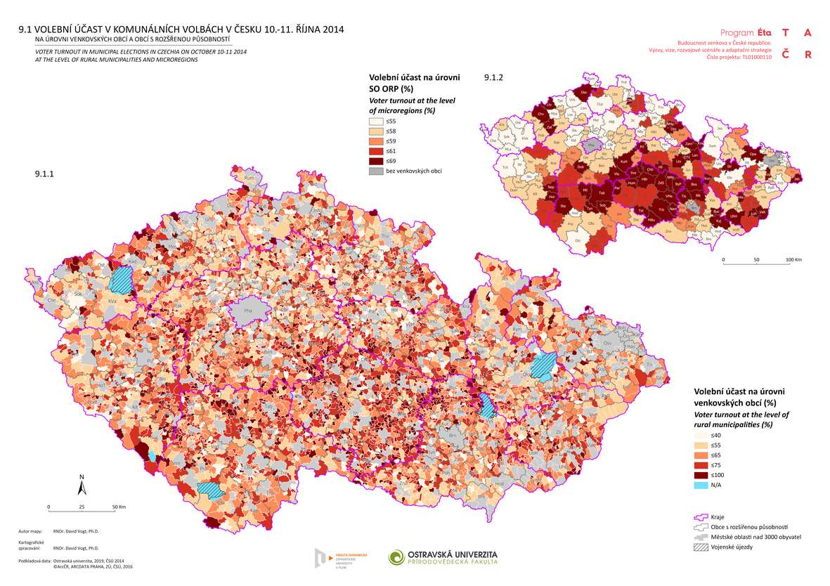
Atlas rozvoje venkova je společný projekt (TAČR) pracovníků Západočeské univerzity v Plzni a Ostravské univerzity, který se zabývá přípravou českého venkova na budoucnost. Klíčovou pozornost věnuje otázkám ekonomického rozvoje a možnostem jeho veřejné podpory (pracovní a podnikatelské příležitosti, základní občanská vybavenost). Cílem projektu je během tří let (2018-2020): analyzovat problémy, rozvojové příležitosti a investiční potřeby venkova, […]
The post Atlas rozvoje venkova appeared first on GISportal.cz.
OneWeb Files for Chapter 11 Restructuring to Execute Sale Process
31.3.2020 0:04 GISCafe.com Webcasts-Webinars Negotiating Debtor-in-Possession Financing to Support its Ongoing Business and a Sale Process
LONDON, UK, March 27, 2020 – …
Omezení provozu Pobočky Kolín
31.3.2020 0:00 Státní pozemkový úřad Z důvodu přerušení dodávky elektrického proudu bude dne 2. 4. 2020 provoz Pobočky Kolín od 8 do 16.30 omezen. Děkujeme za pochopení.Uzavření Pobočky Kolín
31.3.2020 0:00 Státní pozemkový úřad Z důvodu přerušení dodávky elektrického proudu bude dne 2. 4. 2020 uzavřena Pobočka Kolín. Děkujeme za pochopení.Microsoft creates digital twin of Singapore HQ
30.3.2020 21:19 Bentley SystemsPress Coverage
The Record, UK
Read the articleBentley helps build ‘digital twin’ of Microsoft regional HQ
30.3.2020 21:12 Bentley SystemsPress Coverage
The Construction Index, UK
Read the articleDigital twin creates blueprint for future smart buildings
30.3.2020 21:03 Bentley SystemsPress Coverage
BIM Today, UK
Read the articleBentley Systems acquires GroupBC
30.3.2020 20:59 Bentley SystemsPress Coverage
BIM Ireland, UK
Read the articleEsri Offers Students Free Access to Software for Continued Education Through Coronavirus Closures
30.3.2020 20:13 GISCafe.com Webcasts-Webinars Complimentary Technology and Lessons Support Remote Learning during COVID-19 OutbreakREDLANDS, Calif. — (BUSINESS WIRE) — March 30, 2020 …
Transcend Spatial Solutions to Rebrand as Rizing, Expanding Geospatial Services to the SAP Marketplace
30.3.2020 20:13 GISCafe.com Webcasts-Webinars Rizing Geospatial brings location intelligence experience to the transportation industry and SAP customersSTAMFORD, Conn., March 30, 2020 — …
"Covid Near You – Participate in a Harvard Medical School Citizen Science Project" by Sanjay Gangal
30.3.2020 16:19 GISCafe.com Webcasts-WebinarsOmezení ZPH
30.3.2020 13:11 ČÚZK - předpisy a opatření Katastrální úřad pro Jihočeský kraj - Katastrální pracoviště Tábor zveřejnil novou aktualitu: Oznámení o přerušení jednání s vlastníky při zjišťování hranic v terénu:V souvislosti s aktuální situací v ČR bylo rozhodnuto, že nebudeme až do odvolání provádět ústní jednání s vlastníky v terénu - zjišťování průběhu hranic v lokalitách, kde byla tato činnost již zahájena a nebo naplánována a pozvánky vlastníkům nemovitostí byly již rozeslány.
Naplánovaná ústní jednání budou přesunuta na období po ukončení krizového opatření.
Omezení ZPH
30.3.2020 13:11 ČÚZK /Urady/Katastralni-urady/Katastralni-urady/Katastralni-urad-pro-Jihocesky-kraj/Katastralni-pracoviste/KP-Tabor/O-uradu/Aktuality/Omezeni-ZPHOmezení ZPH
30.3.2020 13:08 ČÚZK - předpisy a opatření Katastrální úřad pro Jihočeský kraj - Katastrální pracoviště Strakonice zveřejnil novou aktualitu: Oznámení o přerušení jednání s vlastníky při zjišťování hranic v terénu:V souvislosti s aktuální situací v ČR bylo rozhodnuto, že nebudeme až do odvolání provádět ústní jednání s vlastníky v terénu - zjišťování průběhu hranic v lokalitách, kde byla tato činnost již zahájena a nebo naplánována a pozvánky vlastníkům nemovitostí byly již rozeslány.
Naplánovaná ústní jednání budou přesunuta na období po ukončení krizového opatření.
Omezení ZPH
30.3.2020 13:08 ČÚZK /Urady/Katastralni-urady/Katastralni-urady/Katastralni-urad-pro-Jihocesky-kraj/Katastralni-pracoviste/KP-Strakonice/O-uradu/Aktuality/Omezeni-ZPHOmezení ZPH
30.3.2020 13:02 ČÚZK /Urady/Katastralni-urady/Katastralni-urady/Katastralni-urad-pro-Jihocesky-kraj/Katastralni-pracoviste/KP-Prachatice/O-uradu/Aktuality/Omezeni-ZPHOmezení ZPH
30.3.2020 13:02 ČÚZK - předpisy a opatření Katastrální úřad pro Jihočeský kraj - Katastrální pracoviště Prachatice zveřejnil novou aktualitu: Oznámení o přerušení jednání s vlastníky při zjišťování hranic v terénu:V souvislosti s aktuální situací v ČR bylo rozhodnuto, že nebudeme až do odvolání provádět ústní jednání s vlastníky v terénu - zjišťování průběhu hranic v lokalitách, kde byla tato činnost již zahájena a nebo naplánována a pozvánky vlastníkům nemovitostí byly již rozeslány.
Naplánovaná ústní jednání budou přesunuta na období po ukončení krizového opatření.
Omezení ZPH
30.3.2020 12:57 ČÚZK - předpisy a opatření Katastrální úřad pro Jihočeský kraj - Katastrální pracoviště Písek zveřejnil novou aktualitu: Oznámení o přerušení jednání s vlastníky při zjišťování hranic v terénu:V souvislosti s aktuální situací v ČR bylo rozhodnuto, že nebudeme až do odvolání provádět ústní jednání s vlastníky v terénu - zjišťování průběhu hranic v lokalitách, kde byla tato činnost již zahájena a nebo naplánována a pozvánky vlastníkům nemovitostí byly již rozeslány.
Naplánovaná ústní jednání budou přesunuta na období po ukončení krizového opatření.
Omezení ZPH
30.3.2020 12:57 ČÚZK /Urady/Katastralni-urady/Katastralni-urady/Katastralni-urad-pro-Jihocesky-kraj/Katastralni-pracoviste/KP-Pisek/O-uradu/Aktuality/Omezeni-ZPHOmezení ZPH
30.3.2020 12:53 ČÚZK /Urady/Katastralni-urady/Katastralni-urady/Katastralni-urad-pro-Jihocesky-kraj/Katastralni-pracoviste/KP-Jindrichuv-Hradec/O-uradu/Aktuality/Omezeni-ZPHOmezení ZPH
30.3.2020 12:53 ČÚZK - předpisy a opatření Katastrální úřad pro Jihočeský kraj - Katastrální pracoviště Jindřichův Hradec zveřejnil novou aktualitu: Oznámení o přerušení jednání s vlastníky při zjišťování hranic v terénu:V souvislosti s aktuální situací v ČR bylo rozhodnuto, že nebudeme až do odvolání provádět ústní jednání s vlastníky v terénu - zjišťování průběhu hranic v lokalitách, kde byla tato činnost již zahájena a nebo naplánována a pozvánky vlastníkům nemovitostí byly již rozeslány.
Naplánovaná ústní jednání budou přesunuta na období po ukončení krizového opatření.
Omezení ZPH
30.3.2020 12:50 ČÚZK - předpisy a opatření Katastrální úřad pro Jihočeský kraj - Katastrální pracoviště Český Krumlov zveřejnil novou aktualitu: Oznámení o přerušení jednání s vlastníky při zjišťování hranic v terénu:V souvislosti s aktuální situací v ČR bylo rozhodnuto, že nebudeme až do odvolání provádět ústní jednání s vlastníky v terénu - zjišťování průběhu hranic v lokalitách, kde byla tato činnost již zahájena a nebo naplánována a pozvánky vlastníkům nemovitostí byly již rozeslány.
Naplánovaná ústní jednání budou přesunuta na období po ukončení krizového opatření.
Omezení ZPH
30.3.2020 12:50 ČÚZK /Urady/Katastralni-urady/Katastralni-urady/Katastralni-urad-pro-Jihocesky-kraj/Katastralni-pracoviste/KP-Cesky-Krumlov/O-uradu/Aktuality/Omezeni-ZPHOmezení ZPH
30.3.2020 12:47 ČÚZK /Urady/Katastralni-urady/Katastralni-urady/Katastralni-urad-pro-Jihocesky-kraj/Katastralni-pracoviste/KP-Ceske-Budejovice/O-uradu/Aktuality/Omezeni-ZPHOmezení ZPH
30.3.2020 12:47 ČÚZK - předpisy a opatření Katastrální úřad pro Jihočeský kraj - Katastrální pracoviště České Budějovice zveřejnil novou aktualitu: Oznámení o přerušení jednání s vlastníky při zjišťování hranic v terénu:V souvislosti s aktuální situací v ČR bylo rozhodnuto, že nebudeme až do odvolání provádět ústní jednání s vlastníky v terénu - zjišťování průběhu hranic v lokalitách, kde byla tato činnost již zahájena a nebo naplánována a pozvánky vlastníkům nemovitostí byly již rozeslány.
Naplánovaná ústní jednání budou přesunuta na období po ukončení krizového opatření.
HRDLIČKA spol. s r.o. - Ing. Miroslav Hrdlička oslavil 90. narozeniny
30.3.2020 9:55 Hrdlička Spoluzakladatel naší společnosti oslavil v nedávné době svoje narozeniny..Ing. Miroslav Hrdlička oslavil 90. narozeniny
30.3.2020 9:55 Hrdlička Spoluzakladatel naší společnosti oslavil v nedávné době svoje narozeniny..ESA’s Navigation Directorate supporting EGNOS and Galileo services continuity
30.3.2020 9:35 ESA Navigation
In response to the ongoing Coronavirus pandemic, ESA’s Directorate of Navigation has shifted to teleworking while also ensuring the continuity of essential tasks, in particular the continued delivery of positioning, navigation, and timing services of the European satellite navigation system Galileo and the augmentation system EGNOS.
ESA’s Navigation Directorate supporting EGNOS and Galileo services continuity
30.3.2020 9:35 ESA Navigation
In response to the ongoing Coronavirus pandemic, ESA’s Directorate of Navigation has shifted to teleworking while also ensuring the continuity of essential tasks, in particular the continued delivery of positioning, navigation, and timing services of the European satellite navigation system Galileo and the augmentation system EGNOS.
Vychází tištěný GeoBusiness
30.3.2020 8:17 GISportal.cz
Ne, toto opravdu není aprílová zpráva! Některým z nás/vás již přišel do schránky první tištěný GeoBusiness po opravdu dlouhé době. Šéfredaktor Josef Hnojil hned v úvodníku píše, že tištěný GeoBusiness nevyšel již osm let, a přestože se mi to ani nechce věřit, nebudu mu to rozporovat, protože si to prostě už nepamatuji. Vzhledem k tomu, […]
The post Vychází tištěný GeoBusiness appeared first on GISportal.cz.
Výběrové řízení - ředitel/ka KP Hustopeče
30.3.2020 7:28 ČÚZK - předpisy a opatření Katastrální úřad pro Jihomoravský kraj - Katastrální pracoviště Hustopeče zveřejnil novou aktualitu: Výběrové řízení na služební místo rada/odborný rada - ředitel/ka Katastrálního pracoviště HustopečeVýběrové řízení - ředitel/ka KP Hustopeče
30.3.2020 7:28 ČÚZK /Urady/Katastralni-urady/Katastralni-urady/Katastralni-urad-pro-Jihomoravsky-kraj/Katastralni-pracoviste/KP-Hustopece/O-uradu/Aktuality/Vyberove-rizeni-reditel-ka-KP-HustopeceVýběrové řízení - ředitel/ka KP Hustopeče
30.3.2020 7:18 ČÚZK - předpisy a opatření Katastrální úřad pro Jihomoravský kraj - Katastrální pracoviště Hustopeče zveřejnil novou aktualitu: Výběrové řízení na služební místo rada/odborný rada - ředitel/ka Katastrálního pracoviště HustopečeVýběrové řízení - ředitel/ka KP Hustopeče
30.3.2020 7:18 ČÚZK /Urady/Katastralni-urady/Katastralni-urady/Katastralni-urad-pro-Jihomoravsky-kraj/O-uradu/Aktuality/Vyberove-rizeni-reditel-ka-KP-HustopeceKniha Řízení a správa města
30.3.2020 7:00 Česká asociace pro geoinformace Řízení a správa města - Tomáš HudečekTomáš Hudeček, bývalý primátor Prahy, aktuálně vedoucí oddělení veřejné správy a regionálních studií (ČVUT) a zaměstnanec katedry městského inženýrství (VŠB-TU Ostrava) vydal volně dostupnou knihu Řízení a správa města.
Kniha má tři díly:
Kniha
Nové veřejné nabídky pozemků pro oprávněné osoby podle zákona č. 229/1991 Sb.
30.3.2020 0:00 Státní pozemkový úřad 7. 9. 2020 - Vyhlášení dalšího kola veřejných nabídek pozemků pro oprávněné osoby podle zákona č. 229/1991 Sb.Nové veřejné nabídky pozemků pro oprávněné osoby podle zákona č. 229/1991 Sb.
30.3.2020 0:00 Státní pozemkový úřad 29. 5. 2020 - Vyhlášení dalšího kola veřejných nabídek pozemků pro oprávněné osoby podle zákona č. 229/1991 Sb.Nové veřejné nabídky pozemků pro oprávněné osoby podle zákona č. 229/1991 Sb.
30.3.2020 0:00 Státní pozemkový úřad 16. 11. 2020 - Vyhlášení dalšího kola veřejných nabídek pozemků pro oprávněné osoby podle zákona č. 229/1991 Sb.Vyhledávání koronaviru na Google: Časosběrná mapa, grafy a data
29.3.2020 23:59 Různé Časosběrná mapa související se šířením koronaviru v Evropě a doprovodná data za vybrané státyXXIV Kongres ISPRS odložen
29.3.2020 21:18 Společnost pro fotogrammetrii a dálkový průzkumMezinárodní společnost pro fotogrammetrii a dálkový průzkum (ISPRS) oficiálně oznámila, že v důsledku pandemie nemoci COVID-19 byl XXIV. Kongres ISPRS odložen na rok 2021. Podrobnější informace jsou uvedeny na webových stránkách ISPRS https://www.isprs.org/news/announcements/details.aspx?ID=215
The post XXIV Kongres ISPRS odložen appeared first on SFDP.
Termíny státních závěrečných zkoušek [Katedra aplikované geoinformatiky a kartografie, byTopic]
29.3.2020 17:30 Katedra aplikované geoinformatiky a kartografie Přf UK Jarní a podzimní termíny obhajob bakalářských a diplomových prací a státních závěrečných zkoušek na katedře aplikované geoinformatiky a kartografie v roce 2020.Nové termíny státních závěrečných zkoušek [Katedra aplikované geoinformatiky a kartografie, byTopic]
29.3.2020 17:30 Katedra aplikované geoinformatiky a kartografie Přf UK Pozor! Opatřením děkana č. 06/2020 došlo k úpravě harmonogramu akademického roku 2019/2020.Upraveny byly jarní a podzimní termíny obhajob bakalářských a diplomových prací a státních závěrečných zkoušek na katedře aplikované geoinformatiky a kartografie v roce 2020.
Termíny státních závěrečných zkoušek [Katedra aplikované geoinformatiky a kartografie, byTopic]
29.3.2020 17:30 Katedra aplikované geoinformatiky a kartografie Přf UK Jarní a podzimní termíny obhajob bakalářských a diplomových prací a státních závěrečných zkoušek na katedře aplikované geoinformatiky a kartografie v roce 2020.Pozor! Opatřením děkana č. 06/2020 došlo k úpravě harmonogramu akademického roku 2019/2020.
Termíny státních závěrečných zkoušek [Katedra aplikované geoinformatiky a kartografie, byTopic]
29.3.2020 17:30 Katedra aplikované geoinformatiky a kartografie Přf UK Jarní a podzimní termíny obhajob bakalářských a diplomových prací a státních závěrečných zkoušek na katedře aplikované geoinformatiky a kartografie v roce 2020.Pozor! Z rozhodnutí krizového štábu PřF UK ze dne 6. 4. 2020 budou zde uvedené termíny upraveny.
Termíny státních závěrečných zkoušek [Katedra aplikované geoinformatiky a kartografie, byTopic]
29.3.2020 17:30 Katedra aplikované geoinformatiky a kartografie Přf UK Jarní a podzimní termíny bakalářských a magisterských obhajob a státních závěrečných zkoušek na katedře aplikované geoinformatiky a kartografie v roce 2020.Březnová Online Mapping Party
29.3.2020 8:36 GISportal.cz
Lékaři bez hranic místo tradičního mapathonu pořádají Online Mapping Party, která jak již název napovídá, bude online 🙂 . V čem se bude tato akce lišit a jak se na ni vlastně připravit? online mapathon chat CO VÁS ČEKÁ 18:10 – přivítání na zoomu a úvod k Missing Maps – Zoom Meeting ID: 318 984 018 […]
The post Březnová Online Mapping Party appeared first on GISportal.cz.
Řízení a správa města (kniha zdrama)
29.3.2020 8:28 GISportal.cz
Tomáš Hudeček, bývalý primátor Prahy a v současné době vedoucí oddělení veřejné správy a regionálních studií (ČVUT) a pracovník katedry městského inženýrství (VŠB-TU Ostrava) vydal třídílnou knihu Řízení a správa měst. Knihy jsou zdarma ke stažení na webu IPR Praha (první díl, druhý díl, třetí díl). Kniha Řízení a správa města ve třech dílech (knihách) popisuje […]
The post Řízení a správa města (kniha zdrama) appeared first on GISportal.cz.
Kolik případů koronaviru připadá na 100 tis obyvatel?
28.3.2020 8:19 GISportal.cz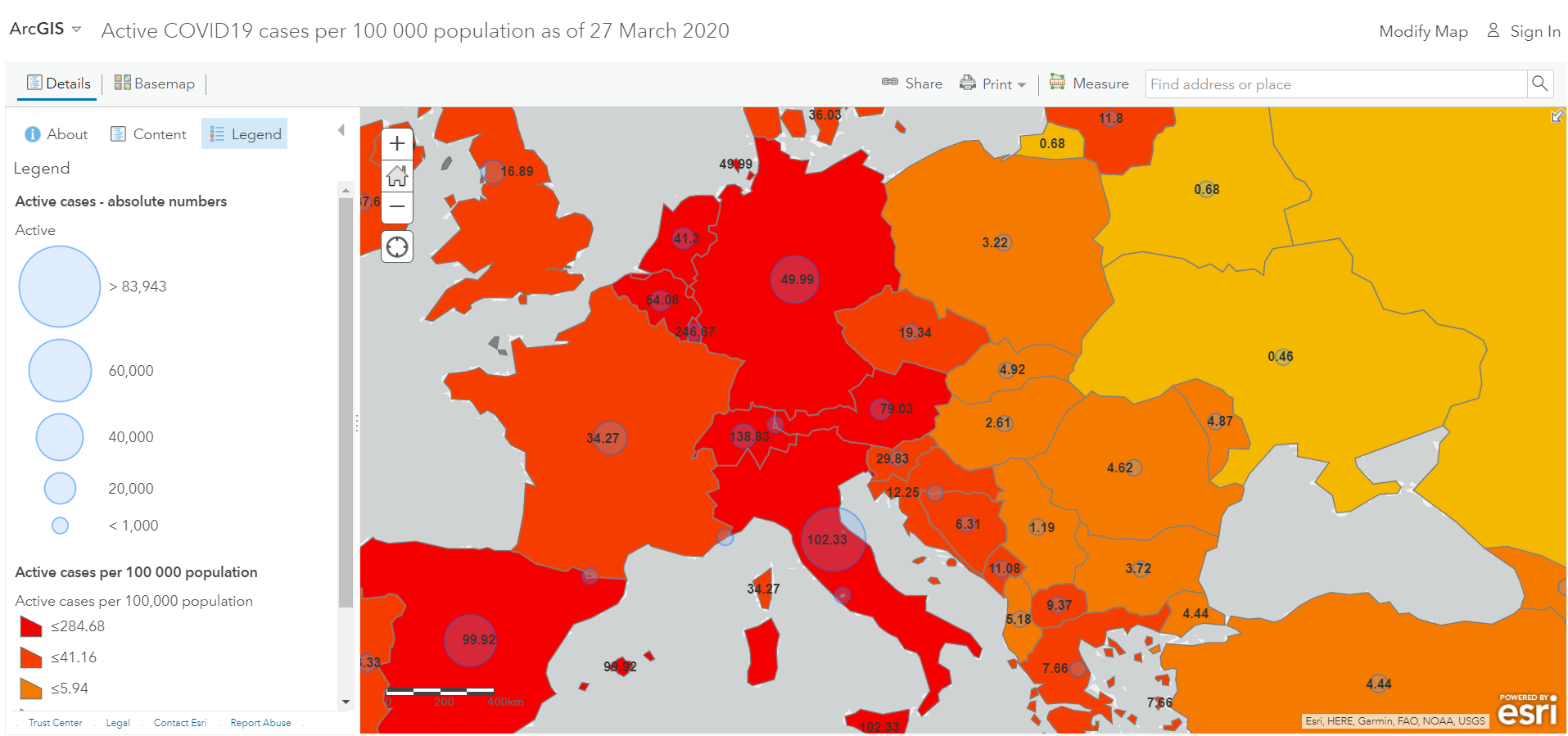
Luděk Krtička z Ostravské univerzity vytvořil další koronavirovou mapu, která ale od většiny ostatních ukazuje poměr nakažených (počet nakažených na 100 tis obyvatel). Mapa konečně umožňuje srovnávat míru nakažení mezi jednotlivými zeměmi. Na druhou stranu je důležité zmínit, že počet nakažených závisí na počtu testů a metodice testování – více o tom píší např. na […]
The post Kolik případů koronaviru připadá na 100 tis obyvatel? appeared first on GISportal.cz.
Suntuity AirWorks Mobilizing Drone Technologies To Help US Cities Fight COVID-19
28.3.2020 2:48 GISCafe.com Webcasts-Webinars By leveraging their DJI Enterprise level Matrice and Agras drones, Suntuity AirWorks is mobilizing their drone equipment and services divisions for …Coronavirus map of the US: latest cases state by state - The Guardian (Google Maps)
28.3.2020 2:48 GISCafe.com Webcasts-WebinarsCovid Near You - Participate in a Harvard Medical School Citizen Science Project
28.3.2020 2:47 GISCafe.com Webcasts-WebinarsUA student creates NWA Resources Map for COVID-19 - Fayetteville Flyer (Google Maps)
27.3.2020 21:06 GISCafe.com Webcasts-WebinarsThis map shows the location of confirmed and potential COVID-19 cases across Canada - blogTO (Google Maps)
27.3.2020 21:06 GISCafe.com Webcasts-WebinarsUnacast Launches Pro Bono Social Distancing Scoreboard As Part of COVID-19 Toolkit
27.3.2020 16:54 GISCafe.com Webcasts-Webinars The Real World Graph® data engine provides valuable insights on social distancing patterns at county and state level for public agencies and …Worldwide Server and Enterprise Storage Systems Markets Will Decline in 2020, Impacted by the COVID-19 Pandemic, According to IDC
27.3.2020 16:54 GISCafe.com Webcasts-Webinars FRAMINGHAM, Mass. — (BUSINESS WIRE) — March 27, 2020 —End user spending on IT infrastructure (server and enterprise storage …
Microsoft creates digital twin of regional HQ
27.3.2020 15:32 Bentley SystemsPress Coverage
Smart Cities World, UK
Read the articleMicrosoft rolls out digital twin using sensors, IoT and AI
27.3.2020 15:26 Bentley SystemsPress Coverage
Gigabit Magazine, UK
Read the articleBentley Systems acquires GroupBC
27.3.2020 15:20 Bentley SystemsPress Coverage
Construction Computing, UK
Read the articleBentley Systems acquires GroupBC to advance collaborative BIM
27.3.2020 15:10 Bentley SystemsPress Coverage
BIM Today, UK
Read the articleBentley Systems Announces the Acquisition of GroupBC
27.3.2020 15:08 Bentley SystemsPress Coverage
GeoConnexion, UK
Read the articleInformace o možnosti bezkontaktního podání
27.3.2020 14:51 ČÚZK - předpisy a opatření Katastrální úřad pro Jihočeský kraj zveřejnil novou aktualitu: Informace o možnosti bezkontaktního podáníNa všech katastrálních pracovištích Katastrálního úřadu pro Jihočeský kraj je možné i mimo omezené úřední hodiny vhodit podání v zalepené obálce do uzavřené sběrné schránky, která je umístěna v blízkosti vstupu do budovy příslušného katastrálního pracoviště (v případě KP Písek ve 3. patře budovy). Je zpřístupněna ve standardních úředních hodinách. Pokud bude v podání uvedena e-mailová adresa, bude na ní zasláno potvrzení o přijetí podání. Za okamžik podání návrhu na vklad se považuje okamžik výběru sběrné schránky. V případě, že je s podáním spojena poplatková povinnost, bude účastníkům zaslána i výzva k úhradě správního poplatku převodem na účet. Děkujeme, že budete v co největší míře využívat této zcela bezkontaktní možnosti podání vůči katastrálnímu úřadu.
Informace o možnosti bezkontaktního podání
27.3.2020 14:51 ČÚZK /Urady/Katastralni-urady/Katastralni-urady/Katastralni-urad-pro-Jihocesky-kraj/O-uradu/Aktuality/Informace-o-moznosti-bezkontaktniho-podaniOznámení 24.3.2020
27.3.2020 12:18 ČÚZK - předpisy a opatření Katastrální úřad pro Středočeský kraj - Katastrální pracoviště Praha-východ zveřejnil novou aktualitu: V části "Úřední deska", v sekci https://www.cuzk.cz/Urady/Katastralni-urady/Katastralni-urady/Katastralni-urad-pro-Stredocesky-kraj/Katastralni-pracoviste/KP-Praha-vychod/Uredni-deska.aspx bylo vystaveno oznámění 24.3.2020Oznámení 24.3.2020
27.3.2020 12:18 ČÚZK /Urady/Katastralni-urady/Katastralni-urady/Katastralni-urad-pro-Stredocesky-kraj/Katastralni-pracoviste/KP-Praha-vychod/O-uradu/Aktuality/Oznameni-24-3-2020Schránka
27.3.2020 11:57 ČÚZK - předpisy a opatření Katastrální úřad pro Vysočinu - Katastrální pracoviště Pelhřimov zveřejnil novou aktualitu: Přestože jsou v souladu s usnesením vlády č.217 ze dne 15.března 2020 úřední hodiny pro veřejnost pouze v pondělí a středu od 8,00 do 11,00 hod., je možné i mimo tyto úřední hodiny vhodit podání v zalepené obálce do uzavřené schránky, která je umístěna ve 2.patře vedle podatelny katastrálního pracoviště.Schránka je zpřístupněna každý den, a to ve dnech pondělí a středa od 8:00 do 15:00, úterý, čtvrtek a pátek od 8:00 do 14:00 hodin. Pokud bude v podání uvedena e-mailová adresa, bude na ní zasláno potvrzení o přijetí podání. V případě, že je s podáním spojena poplatková povinnost, bude účastníkům zaslána i výzva k úhradě správního poplatku převodem na účet.
Děkujeme, že budete v co největší míře využívat této bezkontaktní možnosti.
Schránka
27.3.2020 11:57 ČÚZK /Urady/Katastralni-urady/Katastralni-urady/Katastralni-urad-pro-Vysocinu/Katastralni-pracoviste/KP-Pelhrimov/O-uradu/Aktuality/SchrankaCalling for GNSS apps supporting authorities and citizens in the COVID-19 emergency response and recovery
27.3.2020 11:29 European GNSS Agency
Location is a key requirement when attempting to monitor and map the spread of a disease and GNSS is one of the main tools supporting this. Galileo, currently embedded in over 1.3 billion smartphones and devices worldwide, is helping to increase GNSS accuracy and availability, especially in urban areas. Since the outbreak of the coronavirus earlier this year, many apps have been developed that use GNSS location to monitor the global spread of the virus and to map outbreaks of the COVID-19 disease. GNSS-apps are also proving their usefulness by helping people to implement social distancing in queues and other public spaces.
The European GNSS Agency (GSA)1 is compiling a repository of these apps as a knowledge bank of solutions that are being used to fight the pandemic. If you have developed an app that is already working and being used to map the spread of the coronavirus, to monitor incidences of the disease, or to alert users about possible risky contacts, tell us about it and we will include it in our database. We are also looking for practical apps that facilitate the daily lives of citizens, such as by helping them to manage queues in supermarkets, pharmacies and public spaces or by facilitating the logistics of goods, which has become more complicated in the current situation.
We are looking for apps that are already working and available in app stores. Submit details of your solutions in writing to market@gsa.europa.eu and we will feature them on www.useGalileo.eu/GNSS4Crisis. The goal is for this page to become a toolbox to help authorities, emergency response services, citizens and app developers to understand what resources are currently available and what needs remain unmet.
Watch this: European GNSS Agency: Linking space to user needs
“The coronavirus pandemic is one of the greatest challenges that we are facing as a global society and any effective response will require the use of all available tools. GNSS and apps that leverage GNSS positioning, including Galileo, our ‘made in Europe’ global navigation system, have a key role to play,” said GSA Head of Market Development Fiammetta Diani. “It has always been a core function of the GSA to connect space applications to innovative ideas for the benefit of society. The database we are building now will become a resource for everybody to use, from citizens to organisations and authorities,” she said.
Watch also this: Will Galileo satellites track my phone?
Risk alert
Some examples of apps currently in use include Mapy.cz, a mapping application that has been updated to alert citizens to potential risky encounters through location sharing. User location data is anonymous and the developers are also working to obtain anonymous data about people who tested positive and compare it with the location of users. Advanced algorithms will then make it possible to identify cases of probable contacts with an infected person.
Read this: Space is an enabler of security and defence
Helping people deal with the constraints of lockdown, the Filaindiana (Italian for “single file) web app, which is currently operating only in Lombardy, allows users to check the length of queues in local supermarkets by using real-time crowd-sourced location data from users waiting to enter the supermarkets. This information allows citizens to plan their shopping responsibly and to avoid creating crowds and traffic bottlenecks in certain areas of the city.
Positioning is key
The requirement for reliable and robust positioning in these and in similar apps is clear. Various approaches can be used to increase the robustness and precision of the solution. Dual frequency capability, a key Galileo differentiator, enables GNSS receivers to receive two GNSS signals at different frequencies from a satellite. This provides increased reliability to users – if one of the frequency bands fails, the other can be used as backup. Other benefits include a reduced signal acquisition time, increased resistance to multipath interference, and improved accuracy of positioning and timing.
Developers working in Android also have access to GNSS raw measurements. With the release of Android 7 (Nougat) in 2016, Google made GNSS raw measurements available to users and these raw measurements can be used by developers to improve the positioning accuracy of their solutions.
Share with us your apps and services that leverage these and other benefits of GNSS to provide the positioning needed to map, track, cope with and, hopefully, help halt the spread of this disease.
Media note: This feature can be republished without charge provided the European GNSS Agency (GSA) is acknowledged as the source at the top or the bottom of the story. You must request permission before you use any of the photographs on the site. If you republish, we would be grateful if you could link back to the GSA website (http://www.gsa.europa.eu).
- 1. The GSA disclaims any responsibility concerning: the completeness of the list, possible omissions, the actual fitness for use of the listed applications, the possible breach of third parties’ rights arising from the use of the listed applications.
Calling for GNSS apps supporting authorities and citizens in the COVID-19 emergency response and recovery
27.3.2020 11:29 European GNSS AgencyLocation is a key requirement when attempting to monitor and map the spread of a disease and GNSS is one of the main tools supporting this. Galileo, currently embedded in over 1.3 billion smartphones and devices worldwide, is helping to increase GNSS accuracy and availability, especially in urban areas. Since the outbreak of the coronavirus earlier this year, many apps have been developed that use GNSS location to monitor the global spread of the virus and to map outbreaks of the COVID-19 disease. GNSS-apps are also proving their usefulness by helping people to implement social distancing in queues and other public spaces.
The European GNSS Agency (GSA)1 is compiling a repository of these apps as a knowledge bank of solutions that are being used to fight the pandemic. If you have developed an app that is already working and being used to map the spread of the coronavirus, to monitor incidences of the disease, or to alert users about possible risky contacts, tell us about it and we will include it in our database. We are also looking for practical apps that facilitate the daily lives of citizens, such as by helping them to manage queues in supermarkets, pharmacies and public spaces or by facilitating the logistics of goods, which has become more complicated in the current situation.
We are looking for apps that are already working and available in app stores. Submit details of your solutions in writing to market@gsa.europa.eu and we will feature them on www.useGalileo.eu/GNSS4Crisis. The goal is for this page to become a toolbox to help authorities, emergency response services, citizens and app developers to understand what resources are currently available and what needs remain unmet.
Watch this: European GNSS Agency: Linking space to user needs
“The coronavirus pandemic is one of the greatest challenges that we are facing as a global society and any effective response will require the use of all available tools. GNSS and apps that leverage GNSS positioning, including Galileo, our ‘made in Europe’ global navigation system, have a key role to play,” said GSA Head of Market Development Fiammetta Diani. “It has always been a core function of the GSA to connect space applications to innovative ideas for the benefit of society. The database we are building now will become a resource for everybody to use, from citizens to organisations and authorities,” she said.
Watch also this: Will Galileo satellites track my phone?
Risk alert
Some examples of apps currently in use include Mapy.cz, a mapping application that has been updated to alert citizens to potential risky encounters through location sharing. User location data is anonymous and the developers are also working to obtain anonymous data about people who tested positive and compare it with the location of users. Advanced algorithms will then make it possible to identify cases of probable contacts with an infected person.
Read this: Space is an enabler of security and defence
Helping people deal with the constraints of lockdown, the Filaindiana (Italian for “single file) web app, which is currently operating only in Lombardy, allows users to check the length of queues in local supermarkets by using real-time crowd-sourced location data from users waiting to enter the supermarkets. This information allows citizens to plan their shopping responsibly and to avoid creating crowds and traffic bottlenecks in certain areas of the city.
Positioning is key
The requirement for reliable and robust positioning in these and in similar apps is clear. Various approaches can be used to increase the robustness and precision of the solution. Dual frequency capability, a key Galileo differentiator, enables GNSS receivers to receive two GNSS signals at different frequencies from a satellite. This provides increased reliability to users – if one of the frequency bands fails, the other can be used as backup. Other benefits include a reduced signal acquisition time, increased resistance to multipath interference, and improved accuracy of positioning and timing.
Developers working in Android also have access to GNSS raw measurements. With the release of Android 7 (Nougat) in 2016, Google made GNSS raw measurements available to users and these raw measurements can be used by developers to improve the positioning accuracy of their solutions.
Share with us your apps and services that leverage these and other benefits of GNSS to provide the positioning needed to map, track, cope with and, hopefully, help halt the spread of this disease.
Media note: This feature can be republished without charge provided the European GNSS Agency (GSA) is acknowledged as the source at the top or the bottom of the story. You must request permission before you use any of the photographs on the site. If you republish, we would be grateful if you could link back to the GSA website (http://www.gsa.europa.eu).
- 1. The GSA disclaims any responsibility concerning: the completeness of the list, possible omissions, the actual fitness for use of the listed applications, the possible breach of third parties’ rights arising from the use of the listed applications.