


![]()

zprávy
zdroje zpráv:20200313 - volné místo - Odborný/vrchní referent v oddělení aktualizace katastru nemovitostí KP LT
13.3.2020 11:19 ČÚZK /Urady/Katastralni-urady/Katastralni-urady/Katastralni-urad-pro-Ustecky-kraj/O-uradu/Aktuality/20200313-volne-misto-Odborny-vrchni-referent-v20200313 - volné místo - Odborný/vrchní referent v oddělení aktualizace katastru nemovitostí KP LT
13.3.2020 11:19 ČÚZK - předpisy a opatření Katastrální úřad pro Ústecký kraj - Katastrální pracoviště Litoměřice zveřejnil novou aktualitu: Nabídka volného pracovního místa - Odborný referent / vrchní referent v oddělení aktualizace katastru nemovitostí Katastrálního pracoviště Litoměřice na Katastrálním úřadu pro Ústecký krajOdborný referent / vrchní referent v oddělení aktualizace katastru nemovitostí Katastrálního pracovi
13.3.2020 11:07 ČÚZK - předpisy a opatření Katastrální úřad pro Ústecký kraj Katastrální pracoviště Litoměřicevypisuje výběrové řízení na místo
Odborný referent / vrchní referent v oddělení aktualizace katastru nemovitostí Katastrálního pracoviště Litoměřice na Katastrálním úřadu pro Ústecký kraj
Odborný referent / vrchní referent v oddělení aktualizace katastru nemovitostí Katastrálního pracovi
13.3.2020 11:07 ČÚZK - volná místa Katastrální úřad pro Ústecký kraj Katastrální pracoviště Litoměřice vypisuje výběrové řízení na místo Odborný referent / vrchní referent v oddělení aktualizace katastru nemovitostí Katastrálního pracoviOdborný referent / vrchní referent v oddělení aktualizace katastru nemovitostí Katastrálního pracovi
13.3.2020 11:07 ČÚZK /Urady/Katastralni-urady/Katastralni-urady/Katastralni-urad-pro-Ustecky-kraj/Uredni-deska/Oznameni-a-jina-uredni-sdeleni/Volna-mista/DMS/Odborny-referent-vrchni-referent-v-oddeleni-aktuKoronavirus
13.3.2020 11:02 ČÚZK - předpisy a opatření Katastrální úřad pro Moravskoslezský kraj - Katastrální pracoviště Třinec zveřejnil novou aktualitu: Vážení klienti,žádáme vás, abyste se v zájmu svém i v zájmu zaměstnanců Katastrálního úřadu pro Moravskoslezský kraj v souvislosti s šířením nemoci COVID-19 (Coronavirus) v prostorách budovy Katastrálního úřadu pro Moravskoslezský kraj, Katastrálního pracoviště Třinec, chovali v souladu s doporučeními Ministerstva zdravotnictví ČR, zejména udržovali požadovaný osobní odstup osob přibližně 2 m, nepodávali si ruce, dbali na přísnou hygienu rukou, dodržovali pravidla respirační hygieny a nezdržovali se v prostorách katastrálního pracoviště v případě, že máte respirační obtíže.
Dále vás žádáme, abyste osobní návštěvu katastrálního úřadu v době „stavu nouze“ vyhlášeného vládou ČR zvážili a využívali pouze v neodkladných záležitostech. Ostatní záležitosti vám velmi rádi a co nejrychleji pomůžeme vyřídit po odeznění této situace. K přístupu k údajům katastru nemovitostí lze využít také stránky www.cuzk.cz v sekci nahlížení do katastru nemovitostí, na kterých si také můžete některé výstupy z KN, např. výpis z katastru nemovitostí, elektronicky zakoupit.
Děkujeme vám za pochopení.
Koronavirus
13.3.2020 11:02 ČÚZK /Urady/Katastralni-urady/Katastralni-urady/Katastralni-urad-pro-Moravskoslezsky-kraj/Katastralni-pracoviste/KP-Trinec/O-uradu/Aktuality/KoronavirusKoronavirus
13.3.2020 11:01 ČÚZK - předpisy a opatření Katastrální úřad pro Moravskoslezský kraj - Katastrální pracoviště Opava zveřejnil novou aktualitu: Vážení klienti,žádáme vás, abyste se v zájmu svém i v zájmu zaměstnanců Katastrálního úřadu pro Moravskoslezský kraj v souvislosti s šířením nemoci COVID-19 (Coronavirus) v prostorách budovy Katastrálního úřadu pro Moravskoslezský kraj, Katastrálního pracoviště Opava, chovali v souladu s doporučeními Ministerstva zdravotnictví ČR, zejména udržovali požadovaný osobní odstup osob přibližně 2 m, nepodávali si ruce, dbali na přísnou hygienu rukou, dodržovali pravidla respirační hygieny a nezdržovali se v prostorách katastrálního pracoviště v případě, že máte respirační obtíže.
Dále vás žádáme, abyste osobní návštěvu katastrálního úřadu v době „stavu nouze“ vyhlášeného vládou ČR zvážili a využívali pouze v neodkladných záležitostech. Ostatní záležitosti vám velmi rádi a co nejrychleji pomůžeme vyřídit po odeznění této situace. K přístupu k údajům katastru nemovitostí lze využít také stránky www.cuzk.cz v sekci nahlížení do katastru nemovitostí, na kterých si také můžete některé výstupy z KN, např. výpis z katastru nemovitostí, elektronicky zakoupit.
Děkujeme vám za pochopení.
Koronavirus
13.3.2020 11:01 ČÚZK /Urady/Katastralni-urady/Katastralni-urady/Katastralni-urad-pro-Moravskoslezsky-kraj/Katastralni-pracoviste/KP-Opava/O-uradu/Aktuality/KoronavirusKoronavirus
13.3.2020 11:00 ČÚZK - předpisy a opatření Katastrální úřad pro Moravskoslezský kraj - Katastrální pracoviště Nový Jičín zveřejnil novou aktualitu: Vážení klienti,žádáme vás, abyste se v zájmu svém i v zájmu zaměstnanců Katastrálního úřadu pro Moravskoslezský kraj v souvislosti s šířením nemoci COVID-19 (Coronavirus) v prostorách budovy Katastrálního úřadu pro Moravskoslezský kraj, Katastrálního pracoviště Nový Jičín, chovali v souladu s doporučeními Ministerstva zdravotnictví ČR, zejména udržovali požadovaný osobní odstup osob přibližně 2 m, nepodávali si ruce, dbali na přísnou hygienu rukou, dodržovali pravidla respirační hygieny a nezdržovali se v prostorách katastrálního pracoviště v případě, že máte respirační obtíže.
Dále vás žádáme, abyste osobní návštěvu katastrálního úřadu v době „stavu nouze“ vyhlášeného vládou ČR zvážili a využívali pouze v neodkladných záležitostech. Ostatní záležitosti vám velmi rádi a co nejrychleji pomůžeme vyřídit po odeznění této situace. K přístupu k údajům katastru nemovitostí lze využít také stránky www.cuzk.cz v sekci nahlížení do katastru nemovitostí, na kterých si také můžete některé výstupy z KN, např. výpis z katastru nemovitostí, elektronicky zakoupit.
Děkujeme vám za pochopení.
Koronavirus
13.3.2020 11:00 ČÚZK /Urady/Katastralni-urady/Katastralni-urady/Katastralni-urad-pro-Moravskoslezsky-kraj/Katastralni-pracoviste/KP-Novy-Jicin/O-uradu/Aktuality/KoronavirusKoronavirus
13.3.2020 11:00 ČÚZK /Urady/Katastralni-urady/Katastralni-urady/Katastralni-urad-pro-Moravskoslezsky-kraj/Katastralni-pracoviste/KP-Krnov/O-uradu/Aktuality/KoronavirusKoronavirus
13.3.2020 11:00 ČÚZK - předpisy a opatření Katastrální úřad pro Moravskoslezský kraj - Katastrální pracoviště Krnov zveřejnil novou aktualitu: Vážení klienti,žádáme vás, abyste se v zájmu svém i v zájmu zaměstnanců Katastrálního úřadu pro Moravskoslezský kraj v souvislosti s šířením nemoci COVID-19 (Coronavirus) v prostorách budovy Katastrálního úřadu pro Moravskoslezský kraj, Katastrálního pracoviště Krnov, chovali v souladu s doporučeními Ministerstva zdravotnictví ČR, zejména udržovali požadovaný osobní odstup osob přibližně 2 m, nepodávali si ruce, dbali na přísnou hygienu rukou, dodržovali pravidla respirační hygieny a nezdržovali se v prostorách katastrálního pracoviště v případě, že máte respirační obtíže.
Dále vás žádáme, abyste osobní návštěvu katastrálního úřadu v době „stavu nouze“ vyhlášeného vládou ČR zvážili a využívali pouze v neodkladných záležitostech. Ostatní záležitosti vám velmi rádi a co nejrychleji pomůžeme vyřídit po odeznění této situace. K přístupu k údajům katastru nemovitostí lze využít také stránky www.cuzk.cz v sekci nahlížení do katastru nemovitostí, na kterých si také můžete některé výstupy z KN, např. výpis z katastru nemovitostí, elektronicky zakoupit.
Děkujeme vám za pochopení.
Koronavirus
13.3.2020 10:59 ČÚZK /Urady/Katastralni-urady/Katastralni-urady/Katastralni-urad-pro-Moravskoslezsky-kraj/Katastralni-pracoviste/KP-Frydek-Mistek/O-uradu/Aktuality/KoronavirusKoronavirus
13.3.2020 10:59 ČÚZK - předpisy a opatření Katastrální úřad pro Moravskoslezský kraj - Katastrální pracoviště Frýdek-Místek zveřejnil novou aktualitu: Vážení klienti,žádáme vás, abyste se v zájmu svém i v zájmu zaměstnanců Katastrálního úřadu pro Moravskoslezský kraj v souvislosti s šířením nemoci COVID-19 (Coronavirus) v prostorách budovy Katastrálního úřadu pro Moravskoslezský kraj, Katastrálního pracoviště Frýdek-Místek, chovali v souladu s doporučeními Ministerstva zdravotnictví ČR, zejména udržovali požadovaný osobní odstup osob přibližně 2 m, nepodávali si ruce, dbali na přísnou hygienu rukou, dodržovali pravidla respirační hygieny a nezdržovali se v prostorách katastrálního pracoviště v případě, že máte respirační obtíže.
Dále vás žádáme, abyste osobní návštěvu katastrálního úřadu v době „stavu nouze“ vyhlášeného vládou ČR zvážili a využívali pouze v neodkladných záležitostech. Ostatní záležitosti vám velmi rádi a co nejrychleji pomůžeme vyřídit po odeznění této situace. K přístupu k údajům katastru nemovitostí lze využít také stránky www.cuzk.cz v sekci nahlížení do katastru nemovitostí, na kterých si také můžete některé výstupy z KN, např. výpis z katastru nemovitostí, elektronicky zakoupit.
Děkujeme vám za pochopení.
Koronavirus
13.3.2020 10:58 ČÚZK /Urady/Katastralni-urady/Katastralni-urady/Katastralni-urad-pro-Moravskoslezsky-kraj/Katastralni-pracoviste/KP-Bruntal/O-uradu/Aktuality/KoronavirusKoronavirus
13.3.2020 10:58 ČÚZK - předpisy a opatření Katastrální úřad pro Moravskoslezský kraj - Katastrální pracoviště Bruntál zveřejnil novou aktualitu: Vážení klienti,žádáme vás, abyste se v zájmu svém i v zájmu zaměstnanců Katastrálního úřadu pro Moravskoslezský kraj v souvislosti s šířením nemoci COVID-19 (Coronavirus) v prostorách budovy Katastrálního úřadu pro Moravskoslezský kraj, Katastrálního pracoviště Bruntál, chovali v souladu s doporučeními Ministerstva zdravotnictví ČR, zejména udržovali požadovaný osobní odstup osob přibližně 2 m, nepodávali si ruce, dbali na přísnou hygienu rukou, dodržovali pravidla respirační hygieny a nezdržovali se v prostorách katastrálního pracoviště v případě, že máte respirační obtíže.
Dále vás žádáme, abyste osobní návštěvu katastrálního úřadu v době „stavu nouze“ vyhlášeného vládou ČR zvážili a využívali pouze v neodkladných záležitostech. Ostatní záležitosti vám velmi rádi a co nejrychleji pomůžeme vyřídit po odeznění této situace. K přístupu k údajům katastru nemovitostí lze využít také stránky www.cuzk.cz v sekci nahlížení do katastru nemovitostí, na kterých si také můžete některé výstupy z KN, např. výpis z katastru nemovitostí, elektronicky zakoupit.
Děkujeme vám za pochopení.
Oznámení PD-7514/2020-209 Sibřina
13.3.2020 10:58 ČÚZK - předpisy a opatření Český úřad zeměměřický a katastrální zveřejnil novou aktualitu: Oznámení - PD-7514/2020-209 SibřinaOznámení PD-7514/2020-209 Sibřina
13.3.2020 10:58 ČÚZK /Urady/Katastralni-urady/Katastralni-urady/Katastralni-urad-pro-Stredocesky-kraj/Katastralni-pracoviste/KP-Praha-vychod/O-uradu/Aktuality/Oznameni-PD-7514-2020-209-SibrinaOznámení PD-7514/2020-209 Sibřina
13.3.2020 10:58 ČÚZK - předpisy a opatření Český úřad zeměměřický a katastrálnízveřejnil novou aktualitu: Oznámení - PD-7514/2020-209 Sibřina
Oznámení PD-7514/2020-209 Sibřina
13.3.2020 10:58 ČÚZK - předpisy a opatření Katastrální úřad pro Středočeský kraj - Katastrální pracoviště Praha-východ zveřejnil novou aktualitu: Oznámení - PD-7514/2020-209 SibřinaKoronavirus
13.3.2020 10:57 ČÚZK /Urady/Katastralni-urady/Katastralni-urady/Katastralni-urad-pro-Moravskoslezsky-kraj/Katastralni-pracoviste/KP-Karvina/O-uradu/Aktuality/KoronavirusKoronavirus
13.3.2020 10:57 ČÚZK - předpisy a opatření Katastrální úřad pro Moravskoslezský kraj - Katastrální pracoviště Karviná zveřejnil novou aktualitu: Vážení klienti,žádáme vás, abyste se v zájmu svém i v zájmu zaměstnanců Katastrálního úřadu pro Moravskoslezský kraj v souvislosti s šířením nemoci COVID-19 (Coronavirus) v prostorách budovy Katastrálního úřadu pro Moravskoslezský kraj, Katastrálního pracoviště Karviná, chovali v souladu s doporučeními Ministerstva zdravotnictví ČR, zejména udržovali požadovaný osobní odstup osob přibližně 2 m, nepodávali si ruce, dbali na přísnou hygienu rukou, dodržovali pravidla respirační hygieny a nezdržovali se v prostorách katastrálního pracoviště v případě, že máte respirační obtíže.
Dále vás žádáme, abyste osobní návštěvu katastrálního úřadu v době „stavu nouze“ vyhlášeného vládou ČR zvážili a využívali pouze v neodkladných záležitostech. Ostatní záležitosti vám velmi rádi a co nejrychleji pomůžeme vyřídit po odeznění této situace. K přístupu k údajům katastru nemovitostí lze využít také stránky www.cuzk.cz v sekci nahlížení do katastru nemovitostí, na kterých si také můžete některé výstupy z KN, např. výpis z katastru nemovitostí, elektronicky zakoupit.
Děkujeme vám za pochopení.
Koronavirus
13.3.2020 10:56 ČÚZK - předpisy a opatření Katastrální úřad pro Moravskoslezský kraj - Katastrální pracoviště Ostrava zveřejnil novou aktualitu: Vážení klienti,žádáme vás, abyste se v zájmu svém i v zájmu zaměstnanců Katastrálního úřadu pro Moravskoslezský kraj v souvislosti s šířením nemoci COVID-19 (Coronavirus) v prostorách budovy Katastrálního úřadu pro Moravskoslezský kraj, Katastrálního pracoviště Ostrava, chovali v souladu s doporučeními Ministerstva zdravotnictví ČR, zejména udržovali požadovaný osobní odstup osob přibližně 2 m, nepodávali si ruce, dbali na přísnou hygienu rukou, dodržovali pravidla respirační hygieny a nezdržovali se v prostorách katastrálního pracoviště v případě, že máte respirační obtíže.
Dále vás žádáme, abyste osobní návštěvu katastrálního úřadu v době „stavu nouze“ vyhlášeného vládou ČR zvážili a využívali pouze v neodkladných záležitostech. Ostatní záležitosti vám velmi rádi a co nejrychleji pomůžeme vyřídit po odeznění této situace. K přístupu k údajům katastru nemovitostí lze využít také stránky www.cuzk.cz v sekci nahlížení do katastru nemovitostí, na kterých si také můžete některé výstupy z KN, např. výpis z katastru nemovitostí, elektronicky zakoupit.
Děkujeme vám za pochopení.
Koronavirus
13.3.2020 10:56 ČÚZK /Urady/Katastralni-urady/Katastralni-urady/Katastralni-urad-pro-Moravskoslezsky-kraj/Katastralni-pracoviste/KP-Ostrava/O-uradu/Aktuality/KoronavirusOznámení PD-7514/2020-209 Mukařov
13.3.2020 10:54 ČÚZK - předpisy a opatření Katastrální úřad pro Středočeský kraj - Katastrální pracoviště Praha-východ zveřejnil novou aktualitu: Oznámení - PD-7514/2020-209 MukařovOznámení PD-7514/2020-209 Mukařov
13.3.2020 10:54 ČÚZK - předpisy a opatření Český úřad zeměměřický a katastrální zveřejnil novou aktualitu: Oznámení - PD-7514/2020-209 MukařovOznámení PD-7514/2020-209 Mukařov
13.3.2020 10:54 ČÚZK /Urady/Katastralni-urady/Katastralni-urady/Katastralni-urad-pro-Stredocesky-kraj/Katastralni-pracoviste/KP-Praha-vychod/O-uradu/Aktuality/Oznameni-PD-7514-2020-209-MukarovOznámení PD-7514/2020-209 Mukařov
13.3.2020 10:54 ČÚZK - předpisy a opatření Český úřad zeměměřický a katastrálnízveřejnil novou aktualitu: Oznámení - PD-7514/2020-209 Mukařov
Informace k omezení některých služeb
13.3.2020 10:44 ČÚZK - předpisy a opatření Český úřad zeměměřický a katastrální zveřejnil novou aktualitu:Vážení klienti,
s ohledem na aktuální situaci, související s šířením koronaviru SARS CoV‐2 způsobujícím onemocnění COVID‐19, se snažíme omezit osobní kontakt s veřejností na nezbytné minimum. Základní provoz katastrálního pracoviště pro veřejnost je tedy zachován (podatelna a poskytování údajů z katastru), nicméně až do odvolání omezíme některé naše služby v následujícím rozsahu:
1. Služby, spojené se zápisy do katastru řízeními „Z“ (posuzování záznamových listin, asistence s vyplňováním ohlášení např. pro zápisy staveb, změny druhů pozemků apod.), budou omezeny jen na PONDĚLÍ a STŘEDY. Je nicméně možné, že časem budou tyto služby omezeny úplně. Pro komunikaci v těchto záležitostech prosím upřednostněte telefonickou domluvu nebo písemný styk (ať již poštou, nebo prostřednictvím elektronické pošty či pomocí datových schránek).
2. Naplánovaná ústní jednání budou dle možností zrušena nebo přesunuta na období po ukončení nouzového stavu. Prosíme o pochopení, že až na nezbytně nutné případy nebudeme až do odvolání provádět ústní jednání, a to jak v terénu (např. v souvislosti s revizemi), tak v budově katastrálního pracoviště.
3. Doporučujeme všem našim klientům, aby pro jednání s katastrálním pracovištěm využili přednostně způsoby, které nevyžadují osobní kontakt, např.:
Poštou: Katastrální pracoviště Sokolov, Boženy Němcové 1932, 35601 Sokolov
e‐mailem: kp.sokolov@cuzk.cz
datová schránka: av8iedb
telefonicky: 352 357 711 (podatelna)
Další informace, např. i o alternativních způsobech podání, najdete na stránkách www.cuzk.cz nebo na naší úřední desce.
Děkuji za pochopení a vstřícný přístup.
Ing. Martin Raška, Ph.D.
ředitel Katastrálního pracoviště Sokolov
Informace k omezení některých služeb
13.3.2020 10:44 ČÚZK /Urady/Katastralni-urady/Katastralni-urady/Katastralni-urad-pro-Karlovarsky-kraj/Katastralni-pracoviste/KP-Sokolov/O-uradu/Aktuality/Informace k omezeni nekterych sluzebInformace k omezení některých služeb
13.3.2020 10:44 ČÚZK - předpisy a opatření Katastrální úřad pro Karlovarský kraj - Katastrální pracoviště Sokolov zveřejnil novou aktualitu:Vážení klienti,
s ohledem na aktuální situaci, související s šířením koronaviru SARS CoV‐2 způsobujícím onemocnění COVID‐19, se snažíme omezit osobní kontakt s veřejností na nezbytné minimum. Základní provoz katastrálního pracoviště pro veřejnost je tedy zachován (podatelna a poskytování údajů z katastru), nicméně až do odvolání omezíme některé naše služby v následujícím rozsahu:
1. Služby, spojené se zápisy do katastru řízeními „Z“ (posuzování záznamových listin, asistence s vyplňováním ohlášení např. pro zápisy staveb, změny druhů pozemků apod.), budou omezeny jen na PONDĚLÍ a STŘEDY. Je nicméně možné, že časem budou tyto služby omezeny úplně. Pro komunikaci v těchto záležitostech prosím upřednostněte telefonickou domluvu nebo písemný styk (ať již poštou, nebo prostřednictvím elektronické pošty či pomocí datových schránek).
2. Naplánovaná ústní jednání budou dle možností zrušena nebo přesunuta na období po ukončení nouzového stavu. Prosíme o pochopení, že až na nezbytně nutné případy nebudeme až do odvolání provádět ústní jednání, a to jak v terénu (např. v souvislosti s revizemi), tak v budově katastrálního pracoviště.
3. Doporučujeme všem našim klientům, aby pro jednání s katastrálním pracovištěm využili přednostně způsoby, které nevyžadují osobní kontakt, např.:
Poštou: Katastrální pracoviště Sokolov, Boženy Němcové 1932, 35601 Sokolov
e‐mailem: kp.sokolov@cuzk.cz
datová schránka: av8iedb
telefonicky: 352 357 711 (podatelna)
Další informace, např. i o alternativních způsobech podání, najdete na stránkách www.cuzk.cz nebo na naší úřední desce.
Děkuji za pochopení a vstřícný přístup.
Ing. Martin Raška, Ph.D.
ředitel Katastrálního pracoviště Sokolov
20200313-odpověď na četné dotazy k návrhům na vklad
13.3.2020 10:18 ČÚZK - předpisy a opatření Český úřad zeměměřický a katastrální zveřejnil novou aktualitu: odpověď na četné dotazy k návrhům na vklad Vzhledem k četným dotazům sdělujeme, že návrh na vklad práv i ostatní podání katastrálním úřadům lze činit prostřednictvím provozovatele poštovních služeb nebo elektronicky (e-mailem nebo prostřednictvím datových schránek). Účastníci řízení o vkladu budou v těchto případech vyzváni k úhradě správního poplatku, který lze uhradit převodem na účet. Podrobnosti o elektronických podáních a parametrech přijímaných datových zpráv zde. Základní informace z katastru nemovitostí je možné získat rovněž elektronicky prostřednictvím aplikace Nahlížení do katastru nemovitostí. V této aplikaci je možné prostřednictvím e-shopu získat i úplný výpis z katastru nemovitostí v elektronické podobě bez nutnosti návštěvy katastrálního pracoviště.20200313-odpověď na četné dotazy k návrhům na vklad
13.3.2020 10:18 ČÚZK - předpisy a opatření Český úřad zeměměřický a katastrální zveřejnil novou aktualitu: odpověď na četné dotazy k návrhům na vklad Vzhledem k četným dotazům sdělujeme, že návrh na vklad práv i ostatní podání katastrálním úřadům lze činit prostřednictvím provozovatele poštovních služeb nebo elektronicky (e-mailem nebo prostřednictvím datových schránek). Účastníci řízení o vkladu budou v těchto případech vyzváni k úhradě správního poplatku, který lze uhradit převodem na účet. Podrobnosti o elektronických podáních a parametrech přijímaných datových zpráv zde. Základní informace z katastru nemovitostí je možné získat rovněž elektronicky prostřednictvím aplikace Nahlížení do katastru nemovitostí. V této aplikaci je možné prostřednictvím e-shopu získat i úplný výpis z katastru nemovitostí v elektronické podobě bez nutnosti návštěvy katastrálního pracoviště.20200313-odpověď na četné dotazy k návrhům na vklad
13.3.2020 10:18 ČÚZK /Aktuality-resort/2020/20200313-odpoved-na-cetne-dotazy-k-navrhum-na-vkla20200313-odpověď na četné dotazy k návrhům na vklad
13.3.2020 10:18 ČÚZK - předpisy a opatření Český úřad zeměměřický a katastrální zveřejnil novou aktualitu: odpověď na četné dotazy k návrhům na vklad Vzhledem k četným dotazům sdělujeme, že návrh na vklad práv i ostatní podání katastrálním úřadům lze činit prostřednictvím provozovatele poštovních služeb nebo elektronicky (e-mailem nebo prostřednictvím datových schránek). Účastníci řízení o vkladu budou v těchto případech vyzváni k úhradě správního poplatku, který lze uhradit převodem na účet. Podrobnosti o elektronických podáních a parametrech přijímaných datových zpráv zde. Základní informace z katastru nemovitostí je možné získat rovněž elektronicky prostřednictvím aplikace Náhlížení do katastru nemovitostí. V této aplikaci je možné prostřednictvím e-shopu získat i úplný výpis z katastru nemovitostí v elektronické podobě bez nutnosti návštěvy katastrálního pracoviště. Image:
Victoria Falls
Image:
Victoria Falls
Earth from Space: Victoria Falls
13.3.2020 10:00 ESA Observing the Earth Video:
00:02:43
Video:
00:02:43
In this week's edition of the Earth from Space programme, the Copernicus Sentinel-2 mission takes us over Victoria Falls, one of the world’s greatest natural wonders, which lies along the course of the Zambezi River.
See also Victoria Falls to download the image.
Earth from Space: Victoria Falls
13.3.2020 10:00 ESA Observing the Earth
Video:
00:02:43
In this week's edition of the Earth from Space programme, the Copernicus Sentinel-2 mission takes us over Victoria Falls, one of the world’s greatest natural wonders, which lies along the course of the Zambezi River.
See also Victoria Falls to download the image.
In this week's edition of the Earth from Space programme, the Copernicus Sentinel-2 mission takes us over Victoria Falls, one of the world’s greatest natural wonders, which lies along the course of the Zambezi River.
See also Victoria Falls to download the image.
Farming by Satellite 2020: on your marks, get set, applications open on 16 March
13.3.2020 9:57 European GNSS Agency
Registration for the 5th Farming by Satellite Prize, which aims to promote the use of EGNSS and Earth observation in European and African agriculture, will open on 16 March. If you are a young innovator with an idea for using satellite technologies to enable sustainable farming practices, improve efficiency in agriculture and reduce its environmental impact, this is your chance to win some great prizes!
Innovation is crucial if the agricultural sector is to grow sustainably and meet emerging global challenges such as feeding a growing population and adapting to and mitigating the impacts of climate change. With these challenges in mind, the Farming by Satellite Prize encourages young professionals, farmers and students in Europe to create new, sustainable, and environmentally friendly solutions using Copernicus, EGNOS and Galileo.
Special Africa Prize
The 2020 edition of the Farming by Satellite Prize includes a Special Africa Prize, which aims to encourage young Africans to develop satellite-based solutions that cater to the specific needs and resources of communities and lands in Africa. The Farming by Satellite Prize is a joint initiative between the European GNSS Agency (GSA) and the European Environmental Agency (EEA).
“Agriculture has been an enthusiastic early adopter of satellite technologies to improve performance in the sector. The Farming by Satellite prize aims to tap into this thirst for innovation and support young innovators in delivering applications and services based on Galileo, EGNOS and Copernicus that will contribute to the evolution of agriculture and to meeting some of the critical challenges facing the global community,” said GSA Acting Executive Director Pascal Claudel.
Watch this: European Satellites for Agriculture
“It is clear that we need to make food production much more sustainable and lessen its impact on the environment and climate. Satellite data, technology and innovation can support this change, which is why partnering with this initiative aligns well with the EEA’s commitment to protecting our nature, climate and human health,” said EEA Executive Director Hans Bruyninckx.
An amazing experience
Applicants can take part as individuals or as a team and are invited to register online between March 16 and June 15, 2020. The top teams selected as finalists will enter the competition’s deep dive phase. A total prize purse of EUR 10,000 will be distributed among the top four teams (three in Europe and one in Africa).
First prize in the 2018 edition of the competition went to Teagasc, the Irish Agriculture and Food Development Authority, for FODDERApp a mobile app for grass and grazing management. Commenting at the time, Teagasc team member Gabriela Afrasinei said: “This was an amazing experience; we really enjoyed brainstorming and developing the idea back in Ireland, and meeting all the other finalists and judges was fantastic! We hope to keep these connections in the years to come.”
The 2020 edition of the Farming by Satellite Prize is supported by industry partners such as the agricultural engineering company CLAAS. For more information on the competition, click here.
Media note: This feature can be republished without charge provided the European GNSS Agency (GSA) is acknowledged as the source at the top or the bottom of the story. You must request permission before you use any of the photographs on the site. If you republish, we would be grateful if you could link back to the GSA website (http://www.gsa.europa.eu).
Farming by Satellite 2020: on your marks, get set, applications open on 16 March
13.3.2020 9:57 European GNSS AgencyRegistration for the 5th Farming by Satellite Prize, which aims to promote the use of EGNSS and Earth observation in European and African agriculture, will open on 16 March. If you are a young innovator with an idea for using satellite technologies to enable sustainable farming practices, improve efficiency in agriculture and reduce its environmental impact, this is your chance to win some great prizes!
Innovation is crucial if the agricultural sector is to grow sustainably and meet emerging global challenges such as feeding a growing population and adapting to and mitigating the impacts of climate change. With these challenges in mind, the Farming by Satellite Prize encourages young professionals, farmers and students in Europe to create new, sustainable, and environmentally friendly solutions using Copernicus, EGNOS and Galileo.
Special Africa Prize
The 2020 edition of the Farming by Satellite Prize includes a Special Africa Prize, which aims to encourage young Africans to develop satellite-based solutions that cater to the specific needs and resources of communities and lands in Africa. The Farming by Satellite Prize is a joint initiative between the European GNSS Agency (GSA) and the European Environmental Agency (EEA).
“Agriculture has been an enthusiastic early adopter of satellite technologies to improve performance in the sector. The Farming by Satellite prize aims to tap into this thirst for innovation and support young innovators in delivering applications and services based on Galileo, EGNOS and Copernicus that will contribute to the evolution of agriculture and to meeting some of the critical challenges facing the global community,” said GSA Acting Executive Director Pascal Claudel.
Watch this: European Satellites for Agriculture
“It is clear that we need to make food production much more sustainable and lessen its impact on the environment and climate. Satellite data, technology and innovation can support this change, which is why partnering with this initiative aligns well with the EEA’s commitment to protecting our nature, climate and human health,” said EEA Executive Director Hans Bruyninckx.
An amazing experience
Applicants can take part as individuals or as a team and are invited to register online between March 16 and June 14, 2020. The top teams selected as finalists will enter the competition’s deep dive phase. A total prize purse of EUR 10,000 will be distributed among the top four teams (three in Europe and one in Africa).
First prize in the 2018 edition of the competition went to Teagasc, the Irish Agriculture and Food Development Authority, for FODDERApp a mobile app for grass and grazing management. Commenting at the time, Teagasc team member Gabriela Afrasinei said: “This was an amazing experience; we really enjoyed brainstorming and developing the idea back in Ireland, and meeting all the other finalists and judges was fantastic! We hope to keep these connections in the years to come.”
The 2020 edition of the Farming by Satellite Prize is supported by industry partners such as the agricultural engineering company CLAAS. For more information on the competition, click here.
Media note: This feature can be republished without charge provided the European GNSS Agency (GSA) is acknowledged as the source at the top or the bottom of the story. You must request permission before you use any of the photographs on the site. If you republish, we would be grateful if you could link back to the GSA website (http://www.gsa.europa.eu).
COVID-19
13.3.2020 9:31 ČÚZK /Urady/Zememericke-a-katastralni-inspektoraty/Zememericke-a-katastralni-inspektoraty/Zememericky-a-katastralni-inspektorat-v-CB/O-uradu/Aktuality/COVID-19COVID-19
13.3.2020 9:31 ČÚZK - předpisy a opatření Zeměměřický a katastrální inspektorát v Českých Budějovicích zveřejnil novou aktualitu: Vážení klienti, v souvislosti s aktuálním výskytem epidemie COVID-19 Vás žádáme, abyste přednostně využívali možnosti elektronické komunikace (e-mail, datová schránka) nebo telefonickou komunikaci.Michelin Joins the Avenza Map Store to Digitalize Its Iconic Maps
13.3.2020 8:00 GISCafe.com Webcasts-Webinars GREENVILLE, S.C., March 12, 2020 — (PRNewswire) — As a map publisher and leading mobility company, Michelin has joined the Avenza Map …GIS Ostrava 2020 se mění na videokonferenci
13.3.2020 7:00 Česká asociace pro geoinformace Vzhledem k současné situaci se šířením COVID-19 se GIS Ostrava 2020 s podtitulem Prostorová data pro Smart City a Smart Region uskuteční ve formě videokonference! Platí přibližný časový rámec konání akce, program bude upraven. Všechny potřebné informace pro autory i posluchače jsou dostupné naInternational Lidar Mapping Forum/Geo Week 2020 Postponed
12.3.2020 18:46 GISCafe.com Webcasts-Webinars Diversified Communications, producers of International Lidar Mapping Forum/Geo Week, announced on Tuesday, March 10 that it is postponing the event …Velodyne Lidar Announces Sales Agreement with NAVYA
12.3.2020 18:46 GISCafe.com Webcasts-Webinars Velodyne Lidar Sensors Power NAVYA’s Autonomous, Driverless and Electric ShuttlesSAN JOSE, Calif. — (BUSINESS WIRE) — March 12, 2020 …
Gefos pozastavuje Leica Tour
12.3.2020 17:57 ZeměměřičSpolečnost GEFOS, pořadatel české Leica Tour, oznámila, že vzhledem k vážnému vývoji situace ohledně koronaviru ruší plánování setkání v Pardubicích, Ostravě, Olomouci a Brně. Akce bude dle slov firmy na facebookové stránce nejspíš nahrazena webinářem nebo jinou formou online prezentace. ❗️❗️ DOJELI JSME ❗️❗️ Vážení příznivci Leica Geosystems, vzhledem k vážnému vývoji situace ohledně koronaviru rušíme příští týden […]
The post Gefos pozastavuje Leica Tour appeared first on Zeměměřič.
Bentley Systems, Microsoft and Schneider Electric re-imagine future workplaces with sensors, sustainability, IoT and AI
12.3.2020 17:11 Bentley SystemsPress Coverage
Microsoft, Global
Read the articleCoreLogic Reports 96,000 Homeowners Regained Positive Equity in the Fourth Quarter of 2019
12.3.2020 16:16 GISCafe.com Webcasts-Webinars Continued home price growth drove average home equity gains of $7,300, or 5.4%, per homeowner compared to the fourth quarter of 2018Negative …
Koronavirus COVID-19 a ekonomické ukazatele na analytické mapě Clevermaps.io
12.3.2020 16:01 GeoBusinessFirma CleverMaps připravila vizualizaci šíření koronaviru Covid-19 v jednotlivých zemích světa. Zeptali jsme se šéfa firmy Ondřeje Tomase na detaily, jak aplikace vznikala. Jak dlouho vám trvala příprava vizualizace? Připravovali jsme ji přibližně 3 dny, spolupracovali jsme na ní s Petrem Bartoněm, hlavním ekonomem firmy Natland, který připravoval metriky, jaký ekonomický dopad bude nákaza mít. […]
The post Koronavirus COVID-19 a ekonomické ukazatele na analytické mapě Clevermaps.io appeared first on GeoBusiness.
Koronavirus COVID-19 a ekonomické ukazatele na analytické mapě Clevermaps.io
12.3.2020 16:01 GeoBusinessFirma CleverMaps připravila vizualizaci šíření koronaviru Covid-19 v jednotlivých zemích světa. Zeptali jsme se šéfa firmy Ondřeje Tomase na detaily, jak aplikace vznikla. Jak dlouho vám trvala příprava vizualizace? Připravovali jsme ji přibližně 3 dny, spolupracovali jsme na ní s Petrem Bartoněm, hlavním ekonomem firmy Natland, který připravoval metriky, jaký ekonomický dopad bude nákaza mít. […]
The post Koronavirus COVID-19 a ekonomické ukazatele na analytické mapě Clevermaps.io appeared first on GeoBusiness.
The Promise of a Digital Twin
12.3.2020 14:37 Bentley SystemsPress Coverage
Plant Engineering and Control Engineering, USA
Read the articleInterconnection correction: Meeting the DER challenge
12.3.2020 14:34 Bentley SystemsPress Coverage
Power International and Electric Light & Power, USA
Read the articleChina Railway Sets Benchmark for Full-lifecycle BIM on Beijing-Zhangjiakou Rail Project
12.3.2020 14:26 Bentley SystemsPress Coverage
Railway Age, USA
Read the articleLeadership Required: Civil Engineers and Resilient Infrastructure
12.3.2020 14:20 Bentley SystemsPress Coverage
Civil Engineer, USA
Read the articleInfrastructure digital twins: From vision to reality, from idea to action
12.3.2020 14:14 Bentley SystemsPress Coverage
BIM Today, UK
Read the articleAltereo’s Artificial Intelligence Water Network Asset Management system HpO® wins the French National Grand Prize for Engineering
12.3.2020 12:32 GISCafe.com Webcasts-Webinars March 12, 2020 -- The French National Grand Prize for Engineering is awarded every year to teams having conceived either an outstanding product …Leica Geosystems updates the Leica ConX cloud-based collaboration tool with new functionalities
12.3.2020 12:16 GISCafe.com Webcasts-Webinars Leica Captivate survey field software now integrated(HEERBRUGG, Switzerland, 11 March 2020) – Leica Geosystems, a Hexagon …
Harnessing Galileo to shape the future of IoT
12.3.2020 12:15 European GNSS Agency
Point.IoT, an exciting new programme designed to empower innovation using Galileo and IoT technologies, is offering 10 teams of ambitious entrepreneurs the chance to tackle relevant industry challenges while showcasing the use of European positioning technologies in IoT. The winning team stands to win a cash prize of EUR 20,000. Interested? Apply here!
The Point.IoT competition is centred on two challenges, which were reached following a careful study of where Galileo can make a positive impact on IoT. The first of the challenges asks the teams to design and develop the next generation of asset tracking and management solutions for industries with large-scale infrastructure, such as airports, construction sites and power stations.
As part of the second challenge, the teams are tasked with designing and developing a real-time risk and location monitoring device that can be worn on or around the body to improve personal safety in the workplace. This solution will increase safety because, when site managers can better understand the movements of their personnel, they can create a safer environment for everyone on site.
Essential tools
The Point.IoT programme kicks off with a two-day, action-packed boot camp in Paris, France, where the teams will acquire some essential tools for their work ahead. The teams will also have the opportunity to meet with industry experts who will become their lead, business and technical mentors to guide them on their solution development journey.
Read this: Looking for funding? The EIC may have something for you!
Then the teams will return home for a three-month virtual sprint, during which they will receive one-on-one coaching from industry experts to ensure their solutions are both technically robust and strategically positioned for market success.
Exciting opportunities
Point.IoT culminates in a demo day, where the teams will have the opportunity to showcase their developments. All the teams will pitch their solutions to the jury, which will evaluate each team’s solution and decide on the overall winner and the EUR 20,000 cash prize recipient.
Watch This: #MyGalileoApp Final
It’s not only money that’s on offer however. The jury will also select five teams to take part in a leading investor roadshow. The programme also offers excellent networking, with the teams being introduced to the programme’s corporate partners and maybe even to their first customers. So, if you have an idea for an IoT solution that harnesses Galileo, don’t miss out on this exciting opportunity and sign up before 24 May 2020.
Harnessing Galileo to shape the future of IoT
12.3.2020 12:15 European GNSS AgencyPoint.IoT, an exciting new programme designed to empower innovation using Galileo and IoT technologies, is offering 10 teams of ambitious entrepreneurs the chance to tackle relevant industry challenges while showcasing the use of European positioning technologies in IoT. The winning team stands to win a cash prize of EUR 20,000. Interested? Apply here!
The Point.IoT competition is centred on two challenges, which were reached following a careful study of where Galileo can make a positive impact on IoT. The first of the challenges asks the teams to design and develop the next generation of asset tracking and management solutions for industries with large-scale infrastructure, such as airports, construction sites and power stations.
As part of the second challenge, the teams are tasked with designing and developing a real-time risk and location monitoring device that can be worn on or around the body to improve personal safety in the workplace. This solution will increase safety because, when site managers can better understand the movements of their personnel, they can create a safer environment for everyone on site.
Essential tools
The Point.IoT programme kicks off with a two-day, action-packed boot camp in Paris, France, where the teams will acquire some essential tools for their work ahead. The teams will also have the opportunity to meet with industry experts who will become their lead, business and technical mentors to guide them on their solution development journey.
Read this: Looking for funding? The EIC may have something for you!
Then the teams will return home for a three-month virtual sprint, during which they will receive one-on-one coaching from industry experts to ensure their solutions are both technically robust and strategically positioned for market success.
Exciting opportunities
Point.IoT culminates in a demo day, where the teams will have the opportunity to showcase their developments. All the teams will pitch their solutions to the jury, which will evaluate each team’s solution and decide on the overall winner and the EUR 20,000 cash prize recipient.
Watch This: #MyGalileoApp Final
It’s not only money that’s on offer however. The jury will also select five teams to take part in a leading investor roadshow. The programme also offers excellent networking, with the teams being introduced to the programme’s corporate partners and maybe even to their first customers. So, if you have an idea for an IoT solution that harnesses Galileo, don’t miss out on this exciting opportunity and sign up before 24 May 2020.
Leica Geosystems updates the Leica iCON site solution for better construction positioning
12.3.2020 12:01 GISCafe.com Webcasts-Webinars Efficiently connecting different tasks, machines and teams on construction sites(HEERBRUGG, Switzerland, 11 March 2020) – Leica …
Výpadek - mapové služby
12.3.2020 9:53 CENIA - národní geoportál INSPIRE Vzhledem k výpadku ArcGIS serveru neběží námi poskytované mapové služby. Předběžný termín obnovení provozu je pondělí 16. 3. 2020. Děkujeme za pochopení.Coronavirus v grafech, mapách a dashboardech
12.3.2020 8:57 GISportal.cz
Aniž bychom se chtěli nějak přiživovat na hysterii okolo coronaviru – COVID-19, rádi bychom na jednom místě shrnuli několik zajímavých vizualizací a prezentací šíření této nemoci. Přestože jednotlivé stránky udávají rozdílné počty nakažených – v jednu chvíli mohou být rozdíly až 12 tisíc nakažených (počítáno v době psaní článku), mohou minimálně posloužit pro upřesnění či […]
The post Coronavirus v grafech, mapách a dashboardech appeared first on GISportal.cz.
ZRUŠENO! Den otevřených dveří v Pobočce Žďár nad sázavou
12.3.2020 0:00 Státní pozemkový úřad AKTUALIZACE!Z důvodu opatření proti šíření epidemie koronaviru SARS-CoV-2 a nepříznivého vývoje ve výskytu onemocnění COVID-19 se Den otevřených dveří ruší.
Pozvánka na přednášku "Geovisualization with Immersive Virtual Environments"
12.3.2020 0:00 Geografický ústav MUZveme Vás na přednášku dr. Floriana Hrubeho (Department of Geomatics, Tlalpan, Mexico) na téma
Geovisualization with Immersive Virtual Environments,
která proběhne ve čtvrtek 12. března ve 12:00 hodin v mapovně GÚ.
Dr. Hruby je předním odborníkem v oblasti virtuální reality a zejména v oblasti propojení reálných geografických prostředí a VR.
Den otevřených dveří v Pobočce Žďár nad sázavou
12.3.2020 0:00 Státní pozemkový úřad AKTUALIZACE!Z důvodu opatření proti šíření epidemie koronaviru SARS-CoV-2 a nepříznivého vývoje ve výskytu onemocnění COVID-19 se Den otevřených dveří ruší.
Den otevřených dveří v Pobočce Žďár nad sázavou
12.3.2020 0:00 Státní pozemkový úřad Zaměstnanci Pobočky Žďár nad Sázavou vás zvou ve středu 25. března od 9 do 16 hodin na Den otevřených dveří s názvem „Pozemkové úpravy a koordinace postupu s dotčenými orgány ve státní správě“.ZRUŠENO! Den otevřených dveří v Pobočce Žďár nad sázavou
12.3.2020 0:00 Státní pozemkový úřad AKTUALIZACE!Z důvodu opatření proti šíření epidemie koronaviru SARS-CoV-2 a nepříznivého vývoje ve výskytu onemocnění COVID-19 se Den otevřených dveří ruší.
Den otevřených dveří v Pobočce Žďár nad sázavou
12.3.2020 0:00 Státní pozemkový úřad AKTUALIZACE!Z důvodu opatření proti šíření epidemie koronaviru SARS-CoV-2 a nepříznivého vývoje ve výskytu onemocnění COVID-19 se Den otevřených dveří ruší.
Den otevřených dveří v Pobočce Žďár nad sázavou
12.3.2020 0:00 Státní pozemkový úřad Zaměstnanci Pobočky Žďár nad Sázavou vás zvou ve středu 25. března od 9 do 16 hodin na Den otevřených dveří s názvem „Pozemkové úpravy a koordinace postupu s dotčenými orgány ve státní správě“.Zrušení valné hromady APG & konference GEOMATIKA 2020
11.3.2020 22:18 Asociace podnikatelů v geomatice Vážené dámy, vážení pánové, v návaznosti na nařízení vlády, které nedovoluje pořádat akce nad 100 osob, si Vás dovolujeme informovat, že jsme nuceni zrušit konání valné hromady APG a konference GEOMATIKA 2020 v termínu 17. – 18. 3. 2020. Mrzí nás to, nicméně zdraví je v tuto chvíli přednější a nechceme nikoho vystavovat zbytečnému riziku. O novém termínu akce Vás budeme informovat. Děkujeme […]Zrušení valné hromady APG & konference GEOMATIKA 2020
11.3.2020 22:18 Asociace podnikatelů v geomatice Vážené dámy, vážení pánové, v návaznosti na nařízení vlády, které nedovoluje pořádat akce nad 100 osob, si Vás dovolujeme informovat, že jsme nuceni zrušit konání valné hromady APG a konference GEOMATIKA 2020 v termínu 17. – 18. 3. 2020. Mrzí nás to, nicméně zdraví je v tuto chvíli přednější a nechceme nikoho vystavovat zbytečnému riziku. O novém termínu akce Vás budeme informovat. […]Bluesky 3D Model Supports Glasgow’s Plans for Regeneration
11.3.2020 18:24 GISCafe.com Webcasts-Webinars Leicestershire, UK, 11 March 2020 – A detailed 3D model of Glasgow is helping shape the future of the city centre. Created by aerial mapping …Maxar Statement on COVID-19
11.3.2020 18:23 GISCafe.com Webcasts-Webinars No material impact to date to delivery of backlog, revenue, supply chain; all facilities operationalWESTMINSTER, Colo. — (BUSINESS WIRE) …
XAG Resumes Work and Drone Production to Aid Spring Planting, as China Steadily Recovers from Coronavirus Outbreak
11.3.2020 18:23 GISCafe.com Webcasts-Webinars GUANGZHOU, China, March 11, 2020 — (PRNewswire) — As the spread of coronavirus (COVID-19) slows in China, the country has seen an …U.S. Census Bureau Powers Its First Digital Census With Splunk’s Data-to-Everything Platform
11.3.2020 18:23 GISCafe.com Webcasts-Webinars Splunk Increases Data Collection Quality, Improves Respondent Convenience, Reduces Costs and Strengthens Security for 2020 CensusSAN FRANCISCO …
New Functionality and Options in Topcon Machine Control Provide Contractors With Full Portfolio for All Earthmoving Projects
11.3.2020 18:23 GISCafe.com Webcasts-Webinars Tilt rotation support for automatic excavation, bring-your-own device, mobile apps includedLAS VEGAS — (BUSINESS WIRE) — March 11, 2020 …
Digital Construction Works Announces New Services and Solutions to Accelerate Digital Adoption in Construction
11.3.2020 18:23 GISCafe.com Webcasts-Webinars Improves Operational Workflows and EfficienciesLAS VEGAS — (BUSINESS WIRE) — March 11, 2020 —
The CONEXPO-CON/AGG Conference — …
Greenland and Antarctica losing ice six times faster than expected
11.3.2020 17:00 ESA Observing the Earth
According to a new report, Greenland and Antarctica are losing ice six times faster than in the 1990s – currently on track with the Intergovernmental Panel on Climate Change’s worst-case climate warming scenario.
Bentley Systems Announces the Acquisition of GroupBC, UK Leader in Cloud Services for Construction Information Management
11.3.2020 16:59 Bentley SystemsAdvancing Project and Asset Common Data Environments (CDEs) through Digital Twins
LONDON, UK – March 11, 2020 – Bentley Systems, Incorporated, a leading global provider of comprehensive software and digital twins services for advancing the design, construction, and operations of infrastructure, today announced the acquisition of GroupBC, a leading UK SaaS software innovator. For over twenty years, GroupBC’s and Bentley’s software solutions have been deployed for complementary purposes to improve project and asset information management. The transaction results from GroupBC’s expansion agenda, and Bentley’s investment appetite, for international growth opportunities stemming from the UK’s national initiatives for major infrastructure investment and towards infrastructure digital twins.
GroupBC’s CDE solutions, BC Projects and BC Enterprise+, have been widely applied in the UK for information management respectively across construction and asset estates. Largely due to the UK’s substantiated ROI experience and its global thought leadership, CDEs have become increasingly availed globally in “going digital” for capital projects and resulting assets. In 2019, the UK’s (BS 1192) construction project information management guidelines were largely adopted within the global standard ISO 19650.
Also in 2019, in its inaugural study of the overall market for Collaborative BIM, ARC Advisory Group ranked Bentley’s ProjectWise system as #1 worldwide. The new opportunity is to build on ISO 19650, and GroupBC’s UK information management experience, to advance collaborative BIM, through “evergreen” digital twins, to span infrastructure lifecycles. In combination, Bentley’s iTwin Services will now be leveraged to uniquely connect GroupBC CDEs and ProjectWise CDEs. Through semantic alignment and change synchronization, the resulting digital twins cloud services will securely federate – fully enabling 4D mixed reality and analytics visibility – previously separate CDEs for construction and engineering.
Keith Bentley, Chief Technology Officer for Bentley Systems, said, “Our iTwin cloud services, taking advantage of iModel-based solutions for interoperability, are ideal for federating CDEs. This enables us to assure that the users of our BC SaaS services will benefit from further extending the value of their project and asset information through digital twins. With the help of our new GroupBC colleagues, we will now be able to better serve engineers, contractors, and owners by bringing together their collective IT (information management), OT (operational technologies including reality modeling), and ET (engineering models). I am confident that the resulting improvements in project and asset performance will be consistent with the UK’s demanding but welcome expectations for new ROI breakthroughs from digital twins.”
Simon Horsley, UK regional executive for Bentley Systems, said, “Our many UK users, projects, and owners in common with GroupBC will gain a lot from our joining forces to advance CDEs through digital twins. I have been tasked by Bentley management to help the UK to continue to lead the world in going digital for infrastructure advancement, and our new offerings and colleagues from GroupBC bring essential momentum as we pool resources to meet our market’s expanded ‘infrastructure revolution’ requirements. I particularly welcome to Bentley Systems GroupBC’s co-founders Sanjeev Shah and Stephen Crompton, and CEO Wes Simmons.”
Sanjeev Shah, co-founder of GroupBC, said, “This is a hugely exciting day for our shared accounts and for both our workforces moving forward. The opportunities which arise from bringing our two companies and their respective product portfolios together are enormous, as is the global reach which Bentley can now add for us. Working together we will be even better able to support, through ‘going digital,’ construction and asset lifecycles.”
Stephen Crompton, CPO and co-founder of GroupBC, added, “Bentley is going to provide a great new home for our products to thrive in. GroupBC have always promoted an integrated, best-of-breed approach, and being able to complement our leading software solutions with existing best-of-breed products from Bentley presents a uniquely exciting opportunity for us and our user organizations, opening the door for unparalleled integration between our solutions and bridging the gaps between design, construction and ongoing asset information management.”
Wes Simmons, CEO of GroupBC, said, “Our founders and I would like to thank our equity partner YFM for their visionary support over the last five years. For our GroupBC team, customers, and partners, joining Bentley Systems ensures a future of continued growth, including beyond construction information management through broadly federated digital twins, and international expansion. Here’s to BC CDE and digital twins advancement!”
Image: https://www.bentley.com/-/media/Images/Press Release Images/2020/Group_BC_v2_Screens_1920x1080
Caption: GroupBC offers a highly secure, yet flexible common data environment (CDE), providing powerful document and information management in the cloud for construction projects and built assets.
##
About GroupBC
GroupBC has been developing enterprise-scale information management solutions for construction-related projects and asset owners since 1998. GroupBC’s extensible, UK hosted Common Data Environment (CDE) makes it easy for teams to collaborate, manage and share documents data and spatial information from a central, secure cloud-based platform.
GroupBC is renowned for pushing the boundaries of technology, integrating project and asset data with external systems and datasets in order to provide rich and valuable insights which enable timelier and better decision making. Customers include Balfour Beatty, Costain, Nationwide Building Society, Sainsbury’s and Thames Water.
www.groupbc.com
About Bentley Systems
Bentley Systems is a leading global provider of software solutions to engineers, architects, geospatial professionals, constructors, and owner-operators for the design, construction, and operations of infrastructure. Bentley’s MicroStation-based engineering and BIM applications, and its digital twin cloud services, advance the project delivery (ProjectWise) and the asset performance (AssetWise) of transportation and other public works, utilities, industrial and resources plants, and commercial and institutional facilities.
Bentley Systems employs more than 3,500 colleagues and generates annual revenues of more than $700 million in 172 countries. From inception in 1984, the company has remained majority-owned by its five founding Bentley brothers. www.bentley.com
Bentley, the Bentley logo, AssetWise, iTwin, MicroStation, and ProjectWise are either registered or unregistered trademarks or service marks of Bentley Systems, Incorporated or one of its direct or indirect wholly owned subsidiaries. All other brands and product names are trademarks of their respective owners.
GIS Ostrava 2020 se kvůli koronaviru uskuteční jako videokonference
11.3.2020 16:48 GeoBusinessOrganizátoři sympozia GIS Ostrava 2020 oznámili, že z důvodu současného zákazu shromažďování většího počtu lidí z akce udělají videokonferenci. Na webu je uvedeno Konference se mění na videokonferenci. Platí přibližný časový rámec konání akce, program bude upraven. Připravíme podrobné instrukce jak pro autory tak pro účastníky konference. Snížíme ceny vložného, upravíme podmínky účasti i storna. […]
The post GIS Ostrava 2020 se kvůli koronaviru uskuteční jako videokonference appeared first on GeoBusiness.
GIS Ostrava se kvůli koronaviru uskuteční jako videokonference
11.3.2020 16:48 GeoBusinessOrganizátoři sympozia GIS Ostrava 2020 oznámili, že z důvodu současného zákazu shromažďování většího počtu lidí z akce udělají videokonferenci. Na webu je uvedeno Konference se mění na videokonferenci. Platí přibližný časový rámec konání akce, program bude upraven. Připravíme podrobné instrukce jak pro autory tak pro účastníky konference. Snížíme ceny vložného, upravíme podmínky účasti i storna. […]
The post GIS Ostrava se kvůli koronaviru uskuteční jako videokonference appeared first on GeoBusiness.
Valná hromada i konference APG se přesouvá na jiný termín
11.3.2020 16:43 ZeměměřičAsociace podnikatelů v geomatice oznámila vzhledem k situaci s koronavirem v ČR přesunutí své valné hromady a konference Geomatika 2020 na pozdější termín. Nové datum bude oznámeno ihned, jakmile to bude možné.
The post Valná hromada i konference APG se přesouvá na jiný termín appeared first on Zeměměřič.
Successful launch for Airbus’ Bartolomeo
11.3.2020 11:34 GISCafe.com Webcasts-Webinars Cape Canaveral, 09 March 2020 – The Airbus built Bartolomeo platform has been successfully launched on 06 March from Cape Canaveral, Florida, …Pracovní nabídka "Koordinace rozvoje a aktualizace ZABAGED"
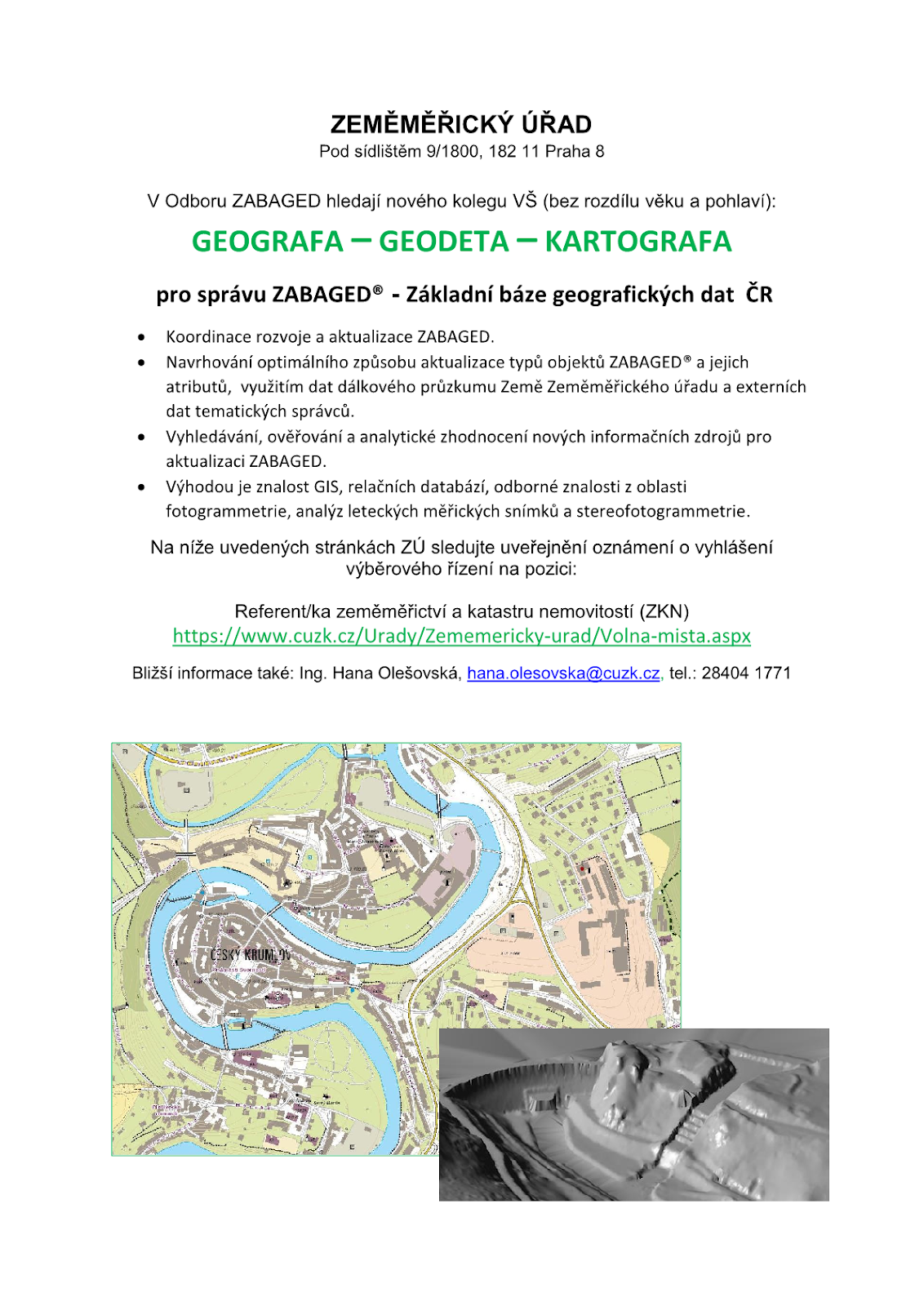
11.3.2020 11:23 Blogující geomatici - FAV ZČU Zeměměřiský úřad hledá nového kolegu VŠ (bez rozdílu věku a pohlaví) v Odboru ZABAGED.Konkrétně pro správu ZABAGED® - Základní báze geografických dat ČR
Náplň práce:
- Koordinace rozvoje a aktualizace ZABAGED.
- Navrhování optimálního způsobu aktualizace typů objektů ZABAGED® a jejich atributů, využitím dat dálkového průzkumu Země Zeměměřického úřadu a externích dat tematických správců.
- Vyhledávání, ověřování a analytické zhodnocení nových informačních zdrojů pro aktualizaci ZABAGED.
Na níže uvedených stránkách ZÚ sledujte uveřejnění oznámení o vyhlášení výběrového řízení také na pozici Referent/ka zeměměřictví a katastru nemovitostí (ZKN).
Stránky: https://www.cuzk.cz/Urady/Zememericky-urad/Volna-mista.aspx
Bližší informace poskytne: Ing. Hana Olešovská, hana.olesovska@cuzk.cz, tel.: 28404 1771
Leica Geosystems introduces the Leica iCON grade solutions for dozers and motor graders on the one-for-all MC1 software platform
11.3.2020 11:11 GISCafe.com Webcasts-Webinars New Leica iCON offering becomes latest addition to one-for-all MC1 software platform(HEERBRUGG, Switzerland, 10 March 2020) – Leica …
ČÚZK v pátek 13.3.2020 od 14:3
11.3.2020 11:03 GEUSware ČÚZK v pátek 13.3.2020 od 14:30 až do 20:00 zcela přeruší provoz Dálkového přístupu (DP) i Webových služeb dálkového přístupu (WSDP). Z tohoto důvodu budou v GEUSu nefunkční Podklady měření a Odesílání GP.Leica Geosystems introduces stringless paving on the one-for-all Leica MC1 software platform
11.3.2020 10:29 GISCafe.com Webcasts-Webinars New Leica iCON offering becomes latest addition to one-for-all MC1 software platform(HEERBRUGG, Switzerland, 10 March 2020) – Leica …
PhD position in Visual analytics of mobile behaviour data in digital cities @ University of Zurich
11.3.2020 10:26 We have an open PhD position in the GIScience center, Department of Geography, University of Zurich on Visual analytics of mobile behaviour data in digital citiesFor detailed information and online application, see https://apply.mnf.uzh.ch/positiondetails/3997698, https://apply.mnf.uzh.ch/position/3997698Please feel free to pass this notification on to potentially interested candidates. Best regards, Tumasch Reichenbacher, PhDSenior LecturerGroup Leader Geovisual analytics and digital transformation Department of GeographyUniversity of ZurichWinterthurerstr. 190CH-8057 Zurich, […]Curator, Geospatial Cultural Heritage (British Library)
11.3.2020 10:24 Please consider applying for the role of Curator, Geospatial Cultural Heritage at the British Library. Further details and information on how to apply are available here: https://britishlibrary.recruitment.zellis.com/birl/pages/vacancy.jsf?latest=01002198 Closing date: 22 March 2020 This full-time role, fixed-term for 18 months offers a unique opportunity to shape strategy in using geospatial data to connect cultural heritage collections and […]Leica Geosystems now offers semi-automatic functionality for the iXE3 3D excavator machine control solution
11.3.2020 10:18 GISCafe.com Webcasts-Webinars Automatic control of boom, bucket, tilt and tilt rotator bucket(HEERBRUGG, Switzerland, 10 March 2020) – Leica Geosystems, a Hexagon …
Galileo Return Link Service delivers excellent performance
11.3.2020 10:02 European GNSS Agency
The first performance evaluation of the Galileo Return Link Service (RLS) following its launch has revealed excellent service provision that exceeds set targets. The Galileo RLS, which allows people in distress to receive automatic acknowledgement that their signal has been received, was declared operational at the 12th European Space Conference on January 21.
The Galileo Search and Rescue (SAR) Service locates people in distress and makes their position known to Rescue Coordination Centres worldwide. At the same time as the launch of the RLS, new targets were also set in January for the SAR/Galileo Forward Link Service, which was declared operational in December 2016.
Excellent performance
For the Galileo Forward Link Service, the new targets aim for 99% service availability and 95% location accuracy within 5 km. Over the first month under the new regime, both parameters were comfortably exceeded reaching 99.9% and 99.8% respectively.
Read this: Successful Galileo Return Link demonstration with market-ready beacon
During the same period, the Galileo Return Link Service was available 100% of the time, above the target value of 95%. On average, the Galileo system took 37 seconds to deliver automatic acknowledgement to the beacon. This is significantly better than the target value of 15 minutes, which was achieved 99.61% of the time.
Global service
The Galileo Return Link Service (RLS) is a free-of-charge global service available to Cospas-Sarsat RLS compatible beacons. The new functionality, currently offered uniquely by Galileo, enables a communication link that relays Return Link Messages (RLM) back to the originating beacon through the Galileo Navigation Signal in Space (I/NAV E1) – for more information, see the updated SAR/Galileo Service Definition Document. The GSA in its role as service provider is continuously monitoring the services provided by the Galileo system, including the Galileo SAR service.
Galileo SAR users that would like to receive more information about the service can send their inquiries to the European GNSS Service Centre Help Desk at: https://www.gsc-europa.eu/.
Media note: This feature can be republished without charge provided the European GNSS Agency (GSA) is acknowledged as the source at the top or the bottom of the story. You must request permission before you use any of the photographs on the site. If you republish, we would be grateful if you could link back to the GSA website (http://www.gsa.europa.eu).
rada/odborný rada - vedoucí oddělení dokumentace KN na Katastrálním pracovišti Nový Jičín
11.3.2020 9:48 ČÚZK - předpisy a opatření Katastrální úřad pro Moravskoslezský kraj - Katastrální pracoviště Nový Jičín zveřejnil novou aktualitu: Oznámení o vyhlášení výběrového řízení na služební místo:rada/odborný rada - vedoucí oddělení dokumentace KN na Katastrálním pracovišti Nový Jičín
rada/odborný rada - vedoucí oddělení dokumentace KN na Katastrálním pracovišti Nový Jičín
11.3.2020 9:48 ČÚZK /Urady/Katastralni-urady/Katastralni-urady/Katastralni-urad-pro-Moravskoslezsky-kraj/O-uradu/Aktuality/rada-odborny-rada-vedouci-oddeleni-dokumentace-KRada/odborný rada - vedoucí oddělení dokumentace KN na Katastrálním pracovišti Nový Jičín
11.3.2020 9:36 ČÚZK /Urady/Katastralni-urady/Katastralni-urady/Katastralni-urad-pro-Moravskoslezsky-kraj/Uredni-deska/Oznameni-a-jina-uredni-sdeleni/Volna-mista/DMS/Rada-odborny-rada-vedouci-oddeleni-dokumentace-KRada/odborný rada - vedoucí oddělení dokumentace KN na Katastrálním pracovišti Nový Jičín
11.3.2020 9:36 ČÚZK - volná místa Katastrální úřad pro Moravskoslezský kraj Katastrální pracoviště Nový Jičín vypisuje výběrové řízení na místo Rada/odborný rada - vedoucí oddělení dokumentace KN na Katastrálním pracovišti Nový JičínRada/odborný rada - vedoucí oddělení dokumentace KN na Katastrálním pracovišti Nový Jičín
11.3.2020 9:36 ČÚZK - předpisy a opatření Katastrální úřad pro Moravskoslezský kraj Katastrální pracoviště Nový Jičínvypisuje výběrové řízení na místo
Rada/odborný rada - vedoucí oddělení dokumentace KN na Katastrálním pracovišti Nový Jičín
Česká Leica Tour pokračuje, oznamuje pořadatelská firma Gefos
11.3.2020 8:10 ZeměměřičSpolečnost GEFOS, jenž v těchto dnech pořádá českou Leica Tour, oznámila, že představovací akce pokračuje. Na jejich facebookové stránce bylo v úterý 10. 3. odpoledne zveřejněno následující oznámení. 🚕🚕! ! LEICA TOUR JEDEME DÁL ! !🚗🚗 Váženi přátelé a podporovatelé Leica Geosystems, vzhledem k mimořádně situaci kvůli koronaviru v České republice a právě probíhající Leica Tour Vám přinášíme několik důležitých informací. 👉Všechny naše […]
The post Česká Leica Tour pokračuje, oznamuje pořadatelská firma Gefos appeared first on Zeměměřič.
A.G.K. 2020 – prípravný kurz pre autorizovaných geodetov a kartografov
11.3.2020 7:17 ZeměměřičKatedra geodézie na Stavebné fakulte STU v Bratislave v spolupráci s Komorou geodetov a kartografov poriada seminár A. G. K. 2020 – Inžinierska geodézia, prípravný kurz pre autorizovaných geodetov a kartografov. Seminár ponúka uchádzačom o získanie odbornej spôsobilosti, ako aj autorizovaným geodetom a kartografom (členom KGK), súbor vybraných prednášok v oblasti inžinierskej geodézie s cieľom aktualizácie úrovne poznania v danej tematike. Vytvára súčasne priestor na […]
The post A.G.K. 2020 – prípravný kurz pre autorizovaných geodetov a kartografov appeared first on Zeměměřič.
APGEO - ZRUŠENÍ VALNÉ HROMADY APG & KONFERENCE GEOMATIKA 2020
11.3.2020 1:00 Asociace podnikatelů v geomatice Vážené dámy, vážení pánové, v návaznosti na nařízení vlády, které nedovoluje pořádat akce nad 100 osob, si Vás ..GeoKARTO 2020
10.3.2020 22:22 GeoBusinessKonferencia je organizovaná každé dva roky Kartografickou spoločnosťou SR v spolupráci s významnými akademickými inštitúciami a je zameraná na aktuálne otázky a trendy z oblasti kartografie, geoinformatiky, geodézie a geografie a ich aplikačnej praxi. V roku 2020 sa konferencia GeoKARTO 2020 bude organizovať v Košiciach v spolupráci s Ústavom geografie Prírodovedeckej fakulty Univerzity Pavla Jozefa […]
The post GeoKARTO 2020 appeared first on GeoBusiness.
Topcon Expands Intelligent Paving Portfolio With Thermal Mapper System
10.3.2020 20:41 GISCafe.com Webcasts-Webinars Temperature quality control to accelerate asphalt paving outcomesLAS VEGAS — (BUSINESS WIRE) — March 10, 2020 —
Topcon …
Netafim Integrates FluroSat's Remote Sensing Technology Into Its Digital Irrigation Management Platform NetBeat™
10.3.2020 20:41 GISCafe.com Webcasts-Webinars TEL-AVIV, Israel, March 10, 2020 — (PRNewswire) — Netafim, the global leader in precision irrigation, and FluroSat, a leading …Bentley Offers Digital Twins for Utility Infrastructure
10.3.2020 19:33 Bentley SystemsOpenFlows SewerOPS CONNECT Edition (Version: 10.03.00.76) Now Available
Bentley is proud to announce the general availability of OpenFlows SewerOPS, a complete predictive solution for wastewater and stormwater networks. The application provides utilities with key advancements for operating a safe and sustainable wastewater collection system.
OpenFlows SewerOPS enables engineers and operators to quickly predict the effects of various events such as high flows, blockages, and power outages to determine the best response. Its easy-to-use interface provides real-time insights for system performance and enables utilities to accurately predict what is about to happen, and how to respond to achieve the best possible outcome.
With OpenFlows SewerOPS, operational departments can prepare for inclement weather. Be ready when storm events exceed the capacity of the collection system by using integrated OpenFlows FLOOD models to calculate the extent of sewer overflows.
Key Capabilities
With these capabilities in OpenFlows SewerOPS, you can quickly visualize what’s happening between monitored locations and predict future system performance instead of waiting for your SCADA system to alert you.
- Analyze combined sewer overflows
- Analyze wastewater network hydraulics
- Manage emergency response
- Predict treatment plant inflows
Leica Tour 2020 na Slovensku pod taktovkou Geotech Bratislava
10.3.2020 18:59 ZeměměřičSpolečnost Geotech Bratislava s. r. o., oficiální obchodní zastoupení značky Leica Geosystems na Slovensku, pořádá v dubnu svoji Leica Tour 2020. Představení geodetické techniky Leica Geosystems se uskuteční v Košicích, Martině a Senci. Program Leica Tour 2020 bude stejný ve všech městech. Košice – 1. 4. 2020 Martin – 2. 4. 2020 Senec – 3. 4. 2020 Program Leica Tour 2020 08:30 – 09:00 […]
The post Leica Tour 2020 na Slovensku pod taktovkou Geotech Bratislava appeared first on Zeměměřič.
Uzavření knihovny pro studenty a veřejnost [Knihovna geografie, byTopic]
10.3.2020 16:50 Katedra aplikované geoinformatiky a kartografie Přf UK Od 11. 3. bude knihovna pro studenty a veřejnost uzavřena.Půjčování knih pro zaměstnance [Knihovna geografie, byTopic]
10.3.2020 16:50 Katedra aplikované geoinformatiky a kartografie Přf UK Z důvodu preventivních opatření v souvislosti s šířením onemocnění novým typem coronaviru COVID-19 bylo rozhodnuto o uzavření Knihovny geografie od 11. 3. 2020 do odvolání.Zaměstnanci mají možnost výpůjček knih po dohodě e-mailem.
Uzavření knihovny pro studenty [Knihovna geografie, byTopic]
10.3.2020 16:50 Katedra aplikované geoinformatiky a kartografie Přf UK Od 11. 3. bude knihovna pro studenty uzavřena.Půjčování knih pro zaměstnance [Knihovna geografie, byTopic]
10.3.2020 16:50 Katedra aplikované geoinformatiky a kartografie Přf UK Od 11. 3. bude knihovna pro studenty a veřejnost uzavřena. Zaměstnanci mají možnost výpůjček knih po dohodě e-mailem.CoreLogic Reports U.S. Overall Delinquency Rate Lowest for a December in at Least 20 Years
10.3.2020 16:33 GISCafe.com Webcasts-Webinars The U.S. serious delinquency rate reached its lowest level since June 2000North Carolina and Mississippi posted the largest annual declines in …
VideoProc Issues New Video Editing Workflow Affecting Millions of DJI Users
10.3.2020 16:33 GISCafe.com Webcasts-Webinars CHENGDU, China — (BUSINESS WIRE) — March 10, 2020 —Digiarty Software is working on the most expecting multimedia software in …
CARMERA and TRI-AD Demonstrate Further Progress on Urban and Highway Mapping in Japan and the US
10.3.2020 16:33 GISCafe.com Webcasts-Webinars CARMERA and Toyota Research Institute-Advanced Development leverage low-cost, widely distributed technology to demonstrate accuracy levels required …Best Drone Fleet Management DJI FlightHub Offered by AirWorks
10.3.2020 16:33 GISCafe.com Webcasts-Webinars DUBAI, Arab Emirates, March 10, 2020 — (PRNewswire) — DJI FlightHub is the ultimate solution to manage all drone operations: …Bluestone Investment Partners Announces Investment in Continental Mapping Consultants, LLC
10.3.2020 16:33 GISCafe.com Webcasts-Webinars Continental Mapping marks Bluestone's seventh investment in the Defense, Government, and National Security MarketMCLEAN, Va., March 10, 2020 — …