


![]()

zprávy
zdroje zpráv:20191211 Odborný / vrchní referent oddělení aktualizace PI KN I.
11.12.2019 15:47 ČÚZK - předpisy a opatření Katastrální úřad pro Středočeský kraj - Katastrální pracoviště Praha-východ Vyhlášení výběrového řízení: Odborný / vrchní referent oddělení aktualizace PI KN I. V části "Úřední deska", v sekci "Oznámení a jiná úřední sdělení" bylo vystaveno "Oznámení o vyhlášení výběrového řízení na obsazení služebního místa Odborný / vrchní referent oddělení aktualizace PI KN I."20191213 Rada / odborný rada právního oddělení
11.12.2019 15:47 ČÚZK /Urady/Katastralni-urady/Katastralni-urady/Katastralni-urad-pro-Stredocesky-kraj/Katastralni-pracoviste/KP-Praha-vychod/O-uradu/Aktuality/20190828-Odborny-rada-oddeleni-pravnich-vztahu-(3)Odborný / vrchní referent oddělení aktualizace PI KN I.
11.12.2019 15:47 ČÚZK - volná místa Katastrální úřad pro Středočeský kraj - Katastrální pracoviště Praha-východ vypisuje výběrové řízení na místo Odborný / vrchní referent oddělení aktualizace PI KN I.Odborný / vrchní referent oddělení aktualizace PI KN I.
11.12.2019 15:47 ČÚZK - předpisy a opatření Katastrální úřad pro Středočeský kraj - Katastrální pracoviště Praha-východvypisuje výběrové řízení na místo Odborný / vrchní referent oddělení aktualizace PI KN I.
Odborný / vrchní referent oddělení aktualizace PI KN I.
Odborný / vrchní referent oddělení aktualizace PI KN I.
11.12.2019 15:47 ČÚZK /Urady/Katastralni-urady/Katastralni-urady/Katastralni-urad-pro-Stredocesky-kraj/Uredni-deska/Oznameni-a-jina-uredni-sdeleni/Volna-mista/Odborny-vrchni-referent-oddeleni-aktualizace-PIVýstava Pavel Aretin z Ehrenfeldu v Teplicích [Knihovna geografie, byTopic]
11.12.2019 12:50 Katedra aplikované geoinformatiky a kartografie Přf UK Výstava Pavel Aretin z Ehrenfeldu: mapa mezi defenestrací a Bílou horou byla v období 14.10.-14.12.2019 k vidění v Gymnáziu Teplice.Put your project in the spotlight at MWC Barcelona
11.12.2019 12:49 European GNSS Agency
Interested in presenting your solution at the world’s largest mobile event? Then read on! The European GNSS Agency (GSA) is looking for innovative solutions to showcase at the Galileo stand at Mobile World Congress in Barcelona on 24-27 February 2020. Every year MWC brings together leading mobile technology developers, manufacturers, service providers and app developers from across the globe. With over 107,000 visitors expected in 2020, next year’s event will be a perfect opportunity to showcase the latest EGNSS-based innovations.
MWC Barcelona will host the latest cutting-edge technologies from more than 2,400 of the world’s leading mobile technology companies. With a programme featuring leading visionaries and investors, the Congress is a not-to-be-missed opportunity to present and promote innovative new ideas, technologies and applications and bring them to the attention of key decision-makers.
With the goal of exploring the hottest trends influencing the mobile industry, MWC Barcelona is an ideal platform to showcase and promote innovative EGNSS-based solutions and applications, such as those being developed within Horizon 2020. The congress also shows how European space research is enhancing EU industrial competitiveness and playing a pivotal role in tackling the various societal challenges facing Europe.
Read this: The GSA and Galileo at MWC Barcelona
“MWC is an ideal chance to present your EGNSS-based solutions and bring your applications to the attention of a large audience of your peers, investors and the public at large. If you have an EGNSS-based solution with the potential to improve the lives of European citizens, then we would like to hear from you,” said GSA Head of Market Development Fiammetta Diani.
Expression of Interest
With this in mind, ahead of next year’s MWC the GSA is launching a call for expressions of interest among its Horizon 2020 and Fundamental Elements partners and other EU companies. The idea is to provide a space at the GSA stand to showcase our partners’ Galileo-enabled mobile solutions. For this edition of the congress, the theme of the GSA stand will be: “Leisure, fitness and sports applications” so priority will be given to solutions that address these markets. If you have an EGNSS-based solution or product that you would like to demonstrate at MWC Barcelona, please submit your application to market@gsa.europa.eu by 3 January 2020. Put “Interested in showcasing our project at MWC 2020” in the subject line of your email. For more information on how to apply read the Rules and Conditions.
This will be an unmissable opportunity to present your solutions to a potential investors and beneficiaries. Join us in Barcelona in February 2020 at MWC, where innovation is celebrated, connections are made, insights are gained, products are launched and business gets done!
EGNSS-based innovation
By matching ideas with opportunities and talent with available resources, MWC Barcelona helps support the GSA in its mission of linking space to user needs. In fact, from dual frequency chipsets to new smartphones, EGNSS was behind many of the technology announcements made during the Mobile World Congress 2019.
And this: Ubiscale: low-power GNSS processing for tracking devices
What’s more, at the MWC 2019, the GSA stand featured displays and presentations on a number of EU projects, including the GSA-managed Horizon 2020 and Fundamental Elements projects Flamingo and ESCAPE, along with solutions from Lycie, Ubiscale, GEO++, Navisoc and Galileo for Mobility. Among the showcased products there was a new solution developed by Ubiscale enabling low-power GNSS sensing and position determination for IoT and a high-accuracy positioning application developed by GEO++, leveraging RTK technology in the backend to apply generated GNSS corrections to smartphone measurements.
Places at the Galileo stand will be limited, so get in touch with us as soon as possible to take advantage of this exciting opportunity!
Media note: This feature can be republished without charge provided the European GNSS Agency (GSA) is acknowledged as the source at the top or the bottom of the story. You must request permission before you use any of the photographs on the site. If you republish, we would be grateful if you could link back to the GSA website (http://www.gsa.europa.eu).
Put your project in the spotlight at MWC Barcelona
11.12.2019 12:49 European GNSS AgencyInterested in presenting your solution at the world’s largest mobile event? Then read on! The European GNSS Agency (GSA) is looking for innovative solutions to showcase at the Galileo stand at Mobile World Congress in Barcelona on 24-27 February 2020. Every year MWC brings together leading mobile technology developers, manufacturers, service providers and app developers from across the globe. With over 107,000 visitors expected in 2020, next year’s event will be a perfect opportunity to showcase the latest EGNSS-based innovations.
MWC Barcelona will host the latest cutting-edge technologies from more than 2,400 of the world’s leading mobile technology companies. With a programme featuring leading visionaries and investors, the Congress is a not-to-be-missed opportunity to present and promote innovative new ideas, technologies and applications and bring them to the attention of key decision-makers.
With the goal of exploring the hottest trends influencing the mobile industry, MWC Barcelona is an ideal platform to showcase and promote innovative EGNSS-based solutions and applications, such as those being developed within Horizon 2020. The congress also shows how European space research is enhancing EU industrial competitiveness and playing a pivotal role in tackling the various societal challenges facing Europe.
Read this: The GSA and Galileo at MWC Barcelona
“MWC is an ideal chance to present your EGNSS-based solutions and bring your applications to the attention of a large audience of your peers, investors and the public at large. If you have an EGNSS-based solution with the potential to improve the lives of European citizens, then we would like to hear from you,” said GSA Head of Market Development Fiammetta Diani.
Expression of Interest
With this in mind, ahead of next year’s MWC the GSA is launching a call for expressions of interest among its Horizon 2020 and Fundamental Elements partners and other EU companies. The idea is to provide a space at the GSA stand to showcase our partners’ Galileo-enabled mobile solutions. For this edition of the congress, the theme of the GSA stand will be: “Leisure, fitness and sports applications” so priority will be given to solutions that address these markets. If you have an EGNSS-based solution or product that you would like to demonstrate at MWC Barcelona, please submit your application to market@gsa.europa.eu by 3 January 2020. Put “Interested in showcasing our project at MWC 2020” in the subject line of your email. For more information on how to apply read the Rules and Conditions.
This will be an unmissable opportunity to present your solutions to a potential investors and beneficiaries. Join us in Barcelona in February 2020 at MWC, where innovation is celebrated, connections are made, insights are gained, products are launched and business gets done!
EGNSS-based innovation
By matching ideas with opportunities and talent with available resources, MWC Barcelona helps support the GSA in its mission of linking space to user needs. In fact, from dual frequency chipsets to new smartphones, EGNSS was behind many of the technology announcements made during the Mobile World Congress 2019.
And this: Ubiscale: low-power GNSS processing for tracking devices
What’s more, at the MWC 2019, the GSA stand featured displays and presentations on a number of EU projects, including the GSA-managed Horizon 2020 and Fundamental Elements projects Flamingo and ESCAPE, along with solutions from Lycie, Ubiscale, GEO++, Navisoc and Galileo for Mobility. Among the showcased products there was a new solution developed by Ubiscale enabling low-power GNSS sensing and position determination for IoT and a high-accuracy positioning application developed by GEO++, leveraging RTK technology in the backend to apply generated GNSS corrections to smartphone measurements.
Places at the Galileo stand will be limited, so get in touch with us as soon as possible to take advantage of this exciting opportunity!
Media note: This feature can be republished without charge provided the European GNSS Agency (GSA) is acknowledged as the source at the top or the bottom of the story. You must request permission before you use any of the photographs on the site. If you republish, we would be grateful if you could link back to the GSA website (http://www.gsa.europa.eu).
Momentum gathers ahead of the inaugural Geo Connect Asia 2020
11.12.2019 11:59 GISCafe.com Webcasts-Webinars Montgomery Asia is excited to announce the first wave of speakers and exhibitors at the March 2020 event, which will be a focal point for the …Prováděli jsme laserové skenování Pravčické brány a okolí v Národním parku České Švýcarsko z dronu
11.12.2019 11:29 UpVisionProváděli jsme laserové skenování Pravčické brány a blízkého okolí v Národním parku České Švýcarsko z dronu pro výzkumný projekt Univerzity Karlovy. Prováděli jsme laserové skenování Pravčické brány a blízkého okolí v Národním parku České Švýcarsko z dronu pro výzkumný projekt Univerzity Karlovy. Zveřejnil(a) UpVision dne Úterý 10. prosince 2019
The post Prováděli jsme laserové skenování Pravčické brány a okolí v Národním parku České Švýcarsko z dronu appeared first on Upvision.
Začínáme se Solid Edge: Modelování dříku křížového šroubováku
11.12.2019 11:22 Konstruktér V dnešním postupu si ukážeme, jak vymodelovat dřík křížového šroubováku. Dřík je jednou částí sestavy celého [...]The UAS community created ‘a new transport ecosystem’ at Amsterdam Drone Week
11.12.2019 11:22 GISCafe.com Webcasts-Webinars Just like the drone industry itself, the Amsterdam Drone Week is rapidly outgrowing its infancy. Together with the High Level Conference on Drones, …GEOTALKS 03 – Rosťa Nétek
11.12.2019 10:25 Katedra geoinformatiky UP OlomoucDalší podcast #GeoTalks je tady🎙️❗️ Rosťa Nétek představí jak se dostal ke geoinformatice a kde geoinformatika dostala jeho 😎 Poslouchejte 🎧 na: ❤️ YouTube: https://youtu.be/O6k29bTqp1U 🖤 Mixcloudu: https://www.mixcloud.com/GeoinformatikaUPOL/geotalks-03-rosťa-nétek/ #bettermapsbetterworld #geoinformaticsupol #upol #upsolvent #podcast
The post GEOTALKS 03 – Rosťa Nétek appeared first on Katedra geoinformatiky.
Earth observation at Space, Security and Defence event
11.12.2019 10:15 ESA Observing the Earth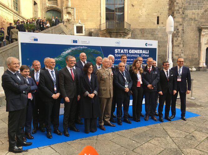
On 6 December, representatives from ESA, the European Parliament, the European Commission and the Italian Space Agency met at the States General for Space, Security and Defence event in Naples, Italy, to discuss upcoming challenges for European industry.
NeQuick G code available for download!
11.12.2019 9:56 European GNSS Agency
A version of the NeQuick G algorithm using a new coding approach is now available for download on the GSC website. This version is the result of intensive recoding by engineers at the EU’s Joint Research Centre.
GNSS signals travelling through the ionosphere can be significantly delayed by the electrical charges in this atmospheric layer before reaching the users’ terminal. To compensate for this delay in the signal, Galileo receivers integrate a dynamic model of the ionosphere composition known as the NeQuick G model. Receiver manufacturers will now be able to benefit from a version of the NeQuick G correction algorithm that implements a new coding approach.
Rigorous testing
The JRC concluded its work recently after successful rigorous testing in the framework of the gLAB tool (GNSS software suite from the Universitat Politecnica de Catalunya). This version of the code has been designed to be highly modular, rendering it more legible for a potential programmer with no specific knowledge about signal propagation in the ionosphere. A library has been also developed to enable its quick integration into existing applications.
Read this: Have your say on the future of Galileo and EGNOS
This software will be released as free and open source software under the terms of the European Union Public Licence (EUPL), version 1.2. The open-source code is now ready to be implemented on single-frequency platforms and can be used on a global scale without limitation under the EUPL. This freedom should contribute to a wider adoption of the NeQuick G model at user level.
This version of the NeQuick G code is available for download on the GSC website. You can register on the site here, and then download the software here.
Media note: This feature can be republished without charge provided the European GNSS Agency (GSA) is acknowledged as the source at the top or the bottom of the story. You must request permission before you use any of the photographs on the site. If you republish, we would be grateful if you could link back to the GSA website (http://www.gsa.europa.eu).
NeQuick G code available for download!
11.12.2019 9:56 European GNSS Agency.")
A version of the NeQuick G algorithm using a new coding approach is now available for download on the GSC website. This version is the result of intensive recoding by engineers at the EU’s Joint Research Centre.
GNSS signals travelling through the ionosphere can be significantly delayed by the electrical charges in this atmospheric layer before reaching the users’ terminal. To compensate for this delay in the signal, Galileo receivers integrate a dynamic model of the ionosphere composition known as the NeQuick G model. Receiver manufacturers will now be able to benefit from a version of the NeQuick G correction algorithm that implements a new coding approach.
Rigorous testing
The JRC concluded its work recently after successful rigorous testing in the framework of the gLAB tool (GNSS software suite from the Universitat Politecnica de Catalunya). This version of the code has been designed to be highly modular, rendering it more legible for a potential programmer with no specific knowledge about signal propagation in the ionosphere. A library has been also developed to enable its quick integration into existing applications.
Read this: Have your say on the future of Galileo and EGNOS
This software will be released as free and open source software under the terms of the European Union Public Licence (EUPL), version 1.2. The open-source code is now ready to be implemented on single-frequency platforms and can be used on a global scale without limitation under the EUPL. This freedom should contribute to a wider adoption of the NeQuick G model at user level.
This version of the NeQuick G code is available for download on the GSC website. You can register on the site here, and then download the software here.
Media note: This feature can be republished without charge provided the European GNSS Agency (GSA) is acknowledged as the source at the top or the bottom of the story. You must request permission before you use any of the photographs on the site. If you republish, we would be grateful if you could link back to the GSA website (http://www.gsa.europa.eu).
Pole koncentrací znečišťujících látek / Air quality model areas (ATOM)
11.12.2019 1:00 Cenia - Katalog metadat ČR - INSPIRE Stahovací služba (ATOM) byla vytvořena na základě dat ČHMÚ a obsahuje vrstvu koncentrace látek znečišťujících ovzduší v gridu 1x1 km.Měřící síť automatických meteorologických, klimatologických a srážkoměrných stanic ČHMÚ
11.12.2019 1:00 Cenia - Katalog metadat ČR - INSPIRE Služba zobrazuje vrstvu automatických meteorologických, klimatologických a srážkoměrech stanic pozorujících k 29.10. 2019 a stanice v síti RBSN (Regional Basic Synoptic Network).Pole koncentrací znečišťujících látek / Air quality model areas (WFS)
11.12.2019 1:00 Cenia - Katalog metadat ČR - INSPIRE Služba byla vytvořena na základě dat ČHMÚ a obsahuje vrstvu imisních charakteristik v gridu 1x1 km.Omezení provozní doby podatelny v budově ústředí
11.12.2019 0:00 Státní pozemkový úřad Z provozně-technických důvodů bude v pátek 13. 12. 2019 provoz podatelny v budově ústředí v Husinecké ulici 1024/11a, v Praze 3 omezen pouze do 11 hodin. Od pondělí 16. 12. 2019 bude podatelna dočasně přemístěna do místnosti č. A220. Děkujeme za pochopení.LeddarTech Partners with First Sensor to Accelerate LiDAR Deployment for Advanced Driver Assistance Systems and Autonomous Driving Applications
10.12.2019 19:42 GISCafe.com Webcasts-Webinars QUEBEC CITY, Dec. 10, 2019 (GLOBE NEWSWIRE) -- LeddarTech®, an industry leader in providing the most versatile and scalable auto and mobility …CoreLogic Reports U.S. Overall Delinquency Rate Lowest for a September in at Least 20 Years
10.12.2019 19:40 GISCafe.com Webcasts-Webinars No states posted an annual gain in overall delinquency rate in SeptemberMississippi, North Carolina, Louisiana, New Jersey and South Carolina …
Kespry Announces Midsouth Aggregates, a Division of CRH, Transforms Mine Planning and Inventory Management with Kespry Drone-Based Aerial Intelligence Platform
10.12.2019 19:40 GISCafe.com Webcasts-Webinars Leading aggregates material provider streamlines mining operations with Kespry, making it more accurate, cost-effective and productiveMENLO PARK, …
Crunchy Certified PostGIS Achieves Open Geospatial Consortium Compliance
10.12.2019 19:40 GISCafe.com Webcasts-Webinars PostGIS, a robust, open source geospatial database layer built on top of PostgreSQL, enables systems to become spatially aware with advanced GIS …Cherre and SafeGraph Partner to Integrate Geospatial Data into Cherre's Award Winning AI Platform
10.12.2019 19:40 GISCafe.com Webcasts-Webinars Adding SafeGraph's Point-of-Interest and Store Location Geofences will provide unique insights for mutual customers to support real estate …Frame.io Makes Its Debut on the iPad
10.12.2019 19:40 GISCafe.com Webcasts-Webinars Frame.io for iPad transforms and enhances the mobile workflow.NEW YORK, Dec. 10, 2019 — (PRNewswire) —
NEW YORK, Dec. 10, 2019 …
UAV Turbines, Inc. Expands Its Microturbine Capabilities to Electrically Powered UAVs
10.12.2019 19:40 GISCafe.com Webcasts-Webinars The Monarch Hybrid Range Extender (HREX) will provide unmatched onboard power and flight time to commercial and military UAVs.MIAMI — …
Edgybees Wins Multiple AFWERX Contracts to Enhance US Air Force Situational Awareness
10.12.2019 19:40 GISCafe.com Webcasts-Webinars Visual intelligence company will provide an augmented reality-enabled software platform to improve situational awareness in complex operational …International Lidar Mapping Forum Announces 2020 Conference Program
10.12.2019 19:40 GISCafe.com Webcasts-Webinars Lineup features dozens of geospatial experts set to discuss pressing issues and emerging technologies in remote sensing.WASHINGTON, Dec. 10, 2019 …
Greenland ice loss much faster than expected
10.12.2019 19:35 ESA Observing the Earth
The Greenland ice sheet is losing mass seven times faster than in the 1990s, according to new research.
Aktuální témata a výzvy v oblasti veřejné dopravy a podpory činnosti složek IZS
10.12.2019 16:45 T-MAPYThe post Aktuální témata a výzvy v oblasti veřejné dopravy a podpory činnosti složek IZS appeared first on T-MAPY spol. s r.o..
HRDLIČKA spol. s r.o. - Získali jsme speciální ocenění
10.12.2019 15:38 Hrdlička Společně s Krajem Vysočina jsme vyhráli speciální ocenění v soutěži Egovernment..Získali jsme speciální ocenění
10.12.2019 15:38 Hrdlička Společně s Krajem Vysočina jsme vyhráli speciální ocenění v soutěži Egovernment..Seven ways cities benefit from digital twins
10.12.2019 15:32 Bentley SystemsPress Coverage
Cities Today, UK
Read the articleAdvancing cities with Digital Twins
10.12.2019 15:30 Bentley SystemsPress Coverage
Geospatial Engineering, UK
Read the articleUnlocking the benefits of going digital in construction
10.12.2019 15:26 Bentley SystemsPress Coverage
Civil Engineering Surveyor, UK
Read the article“BIM is not big data”
10.12.2019 15:23 Bentley SystemsPress Coverage
Extranet Evolution, UK
Read the articleFinalists announced for Year in Infrastructure 2019 awards
10.12.2019 15:21 Bentley SystemsPress Coverage
Infrastructure Intelligence, UK
Read the articleHRDLIČKA spol. s r.o. - Proběhl tradiční golfový turnaj Geotrain Cup 2019
10.12.2019 15:06 Hrdlička Tradiční golfový turnaj pořádaný společnostmi HRDLIČKA spol. s r.o. a AŽD s.r.o. proběhl letos až ke konci září.Proběhl tradiční golfový turnaj Geotrain Cup 2019
10.12.2019 15:06 Hrdlička Tradiční golfový turnaj pořádaný společnostmi HRDLIČKA spol. s r.o. a AŽD s.r.o. proběhl letos až ke konci září.HRDLIČKA spol. s r.o. - Začali jsme zaměřovat vysokorychlostní tratě na Moravě
10.12.2019 15:00 Hrdlička Správa železniční dopravní cesty (SŽDC) v minulých dnech uzavřela smlouvy na geodetická zaměření železničních úseků.Začali jsme zaměřovat vysokorychlostní tratě na Moravě
10.12.2019 15:00 Hrdlička Správa železniční dopravní cesty (SŽDC) v minulých dnech uzavřela smlouvy na geodetická zaměření železničních úseků.HRDLIČKA spol. s r.o. - Studenti z VŠE na exkurzi v sídle společnosti HRDLIČKA
10.12.2019 14:39 Hrdlička Poslední listopadový týden jsme v sídle společnosti HRDLIČKA přivítali studenty..Studenti z VŠE na exkurzi v sídle společnosti HRDLIČKA
10.12.2019 14:39 Hrdlička Poslední listopadový týden jsme v sídle společnosti HRDLIČKA přivítali studenty..Omezení úředních hodin 31.12.2019 ZKI v Praze
10.12.2019 14:27 ČÚZK - předpisy a opatření Zeměměřický a katastrální inspektorát v Praze zveřejnil novou aktualitu: Omezení úředních hodinDne 31.12.2019 budou úřední hodiny na Zeměměřickém a katastrálním inspektorátu v Praze 8,00 – 12,00 hodin.
Děkujeme za pochopení.
Omezení úředních hodin 31.12.2019 ZKI v Praze
10.12.2019 14:27 ČÚZK /Urady/Zememericke-a-katastralni-inspektoraty/Zememericke-a-katastralni-inspektoraty/Zememericky-a-katastralni-inspektorat-v-Praze/O-uradu/Aktuality/Omezeni-urednich-hodin-ZKI-v-PrazePRoPART demonstrates highly accurate automotive positioning solution
10.12.2019 14:15 European GNSS Agency
The Horizon 2020-funded PRoPART project successfully tested a Galileo-based positioning solution enhanced with Real Time Kinematic (RTK) technique for automated trucks and advanced driver assistance systems at the AstaZero Proving Ground in Sandhult, near Borås, Sweden, at the end of November. Combining Galileo’s differentiators with other positioning and sensor technologies, the solution offers reliable cm-level accuracy using correction data from reference stations.
Autonomous vehicles/trucks and advanced driver assistance systems need robust and precise positioning to enhance safety and efficiency and enable reliable operations. This is especially important in the early transition phase when not all vehicles will be automated.
PRoPART has achieved this goal by exploiting the distinguishing features of Galileo in combination with other positioning sensors and technologies, which it shares using V2X technology. The innovative solution developed during the project has the potential to be a game changer for autonomous transport in the future.
A game changer
The solution was demonstrated in a recreated highway situation, with a connected autonomous truck and two unconnected manned cars. As part of the test, a Scania self-driving truck executed a safe and efficient lane change managed by the PRoPART system, relying on centimetre-level positioning combined with collaborative perception sensor data.
Watch this: PRoPART - Precise and Robust Positioning for Automated Road Transport
“Galileo is a key component of the PRoPART platform, and contributes to maintaining the integrity of the information which is essential,” said GSA Head of Market Development Fiammetta Diani.
PRoPART is an important project, in the sense that it delivers robust positioning and timing for future autonomous road transport that fulfils the various needs of vehicle OEMs. It uses object detection sensors as well as PVT information from the GNSS engine along with similar information from road side detection units. This allows it to remotely sense non-connected vehicles, offering a reliable solution for the transition period when both automated and non-automated vehicles will be using the roads.
A truly European venture
The project combines RTK positioning software from Waysure (Sweden) with satellite measurements, in particular advanced and wide band Galileo signals for improved accuracy and enabled with authentication, as developed by Fraunhofer IIS (Germany). The satellite positioning is augmented with an Ultra-Wideband (UWB) ranging solution from Spanish research institution Ceit-IK4.
Read this: First Galileo-enabled autonomous vehicle successfully demonstrated
The self-driving truck was supplied by Scania, with Hungary-based V2X company Commsignia providing the C-ITS technology. Baselabs from Germany provided fusion of sensor data from on-board and road-side sensors and developed a situational assessment for the automated lane change manoeuvre. The project was coordinated by the Research Institute of Sweden (RISE) and received funding from the GSA under the European Union’s Horizon 2020 innovation programme (grant agreement No 776307).
Media note: This feature can be republished without charge provided the European GNSS Agency (GSA) is acknowledged as the source at the top or the bottom of the story. You must request permission before you use any of the photographs on the site. If you republish, we would be grateful if you could link back to the GSA website (http://www.gsa.europa.eu).
PRoPART demonstrates highly accurate automotive positioning solution
10.12.2019 14:15 European GNSS AgencyThe Horizon 2020-funded PRoPART project successfully tested a Galileo-based positioning solution enhanced with Real Time Kinematic (RTK) technique for automated trucks and advanced driver assistance systems at the AstaZero Proving Ground in Sandhult, near Borås, Sweden, at the end of November. Combining Galileo’s differentiators with other positioning and sensor technologies, the solution offers reliable cm-level accuracy using correction data from reference stations.
Autonomous vehicles/trucks and advanced driver assistance systems need robust and precise positioning to enhance safety and efficiency and enable reliable operations. This is especially important in the early transition phase when not all vehicles will be automated.
PRoPART has achieved this goal by exploiting the distinguishing features of Galileo in combination with other positioning sensors and technologies, which it shares using V2X technology. The innovative solution developed during the project has the potential to be a game changer for autonomous transport in the future.
A game changer
The solution was demonstrated in a recreated highway situation, with a connected autonomous truck and two unconnected manned cars. As part of the test, a Scania self-driving truck executed a safe and efficient lane change managed by the PRoPART system, relying on centimetre-level positioning combined with collaborative perception sensor data.
Watch this:PRoPART Project - Precise and Robust Positioning for Automated Road Transports
“Galileo is a key component of the PRoPART platform, and contributes to maintaining the integrity of the information which is essential,” said GSA Head of Market Development Fiammetta Diani.
PRoPART is an important project, in the sense that it delivers robust positioning and timing for future autonomous road transport that fulfils the various needs of vehicle OEMs. It uses object detection sensors as well as PVT information from the GNSS engine along with similar information from road side detection units. This allows it to remotely sense non-connected vehicles, offering a reliable solution for the transition period when both automated and non-automated vehicles will be using the roads.
A truly European venture
The project combines RTK positioning software from Waysure (Sweden) with satellite measurements, in particular advanced and wide band Galileo signals for improved accuracy and enabled with authentication, as developed by Fraunhofer IIS (Germany). The satellite positioning is augmented with an Ultra-Wideband (UWB) ranging solution from Spanish research institution Ceit-IK4.
And this: First Galileo-enabled autonomous vehicle successfully demonstrated
The self-driving truck was supplied by Scania, with Hungary-based V2X company Commsignia providing the C-ITS technology. Baselabs from Germany provided fusion of sensor data from on-board and road-side sensors and developed a situational assessment for the automated lane change manoeuvre. The project was coordinated by the Research Institute of Sweden (RISE) and received funding from the GSA under the European Union’s Horizon 2020 innovation programme (grant agreement No 776307).
Media note: This feature can be republished without charge provided the European GNSS Agency (GSA) is acknowledged as the source at the top or the bottom of the story. You must request permission before you use any of the photographs on the site. If you republish, we would be grateful if you could link back to the GSA website (http://www.gsa.europa.eu).
odborný/vrchní referent - poskytování informací KN a PK, poskytování podkladů, nahlížení do KN v odd
10.12.2019 11:55 ČÚZK /Urady/Katastralni-urady/Katastralni-urady/Katastralni-urad-pro-Jihocesky-kraj/Uredni-deska/Oznameni-a-jina-uredni-sdeleni/Volna-mista/DMS/odborny-vrchni-referent-poskytovani-informaci-KNodborný/vrchní referent - poskytování informací KN a PK, poskytování podkladů, nahlížení do KN v odd
10.12.2019 11:55 ČÚZK - předpisy a opatření Katastrální úřad pro Jihočeský kraj Katastrální pracoviště Jindřichův Hradecvypisuje výběrové řízení na místo
odborný/vrchní referent - poskytování informací KN a PK, poskytování podkladů, nahlížení do KN v oddělení dokumentace KN Katastrálního pracoviště Jindřichův Hradec (ID SM 30000368/30089254)
odborný/vrchní referent - poskytování informací KN a PK, poskytování podkladů, nahlížení do KN v odd
10.12.2019 11:55 ČÚZK - volná místa Katastrální úřad pro Jihočeský kraj Katastrální pracoviště Jindřichův Hradec vypisuje výběrové řízení na místo odborný/vrchní referent - poskytování informací KN a PK, poskytování podkladů, nahlížení do KN v odd20191210 Rada / odborný rada oddělení právních vztahů k nemovitostem
10.12.2019 11:49 ČÚZK /Urady/Katastralni-urady/Katastralni-urady/Katastralni-urad-pro-Stredocesky-kraj/Katastralni-pracoviste/KP-Melnik/O-uradu/Aktuality/20190828-Odborny-rada-oddeleni-pravnich-vztahu-(3)20191210 Rada / odborný rada oddělení právních vztahů k nemovitostem
10.12.2019 11:49 ČÚZK - předpisy a opatření Katastrální úřad pro Středočeský kraj - Katastrální pracoviště Kladno Vyhlášení výběrového řízení: Rada / odborný rada oddělení právních vztahů k nemovitostem V části "Úřední deska", v sekci "Oznámení a jiná úřední sdělení" bylo vystaveno "Oznámení o vyhlášení výběrového řízení na obsazení služebního místa Rada / odborný rada oddělení právních vztahů k nemovitostem"Rada / odborný rada oddělení právních vztahů k nemovitostem
10.12.2019 11:47 ČÚZK /Urady/Katastralni-urady/Katastralni-urady/Katastralni-urad-pro-Stredocesky-kraj/Uredni-deska/Oznameni-a-jina-uredni-sdeleni/Volna-mista/Rada-odborny-rada-oddeleni-pravnich-vztahu-k-n-(5)Rada / odborný rada oddělení právních vztahů k nemovitostem
10.12.2019 11:47 ČÚZK - volná místa Katastrální úřad pro Středočeský kraj - Katastrální pracoviště Mělník vypisuje výběrové řízení na místo Rada / odborný rada oddělení právních vztahů k nemovitostemRada / odborný rada oddělení právních vztahů k nemovitostem
10.12.2019 11:47 ČÚZK - předpisy a opatření Katastrální úřad pro Středočeský kraj - Katastrální pracoviště Mělníkvypisuje výběrové řízení na místo Rada / odborný rada oddělení právních vztahů k nemovitostem
Rada / odborný rada oddělení právních vztahů k nemovitostem
Termíny Leica Tour 2020
10.12.2019 10:15 ZeměměřičSpolečnost Gefos zve na svoji každoroční Leica Tour, tentokrát s číslovkou 2020. V pořadí již 21. ročník Leica Tour 2020 se bude konat v sedmi městech. Určitě si vyberete místo, které vám bude nejblíže. Ústí nad Labem: pondělí 9.3.2020, Clarion Congress Hotel, Špitálské nám. 3517 Karlovy Vary: úterý 10.3.2020, Hotel Dvorana, Chebská 44 České Budějovice: středa 11.3.2020, Clarion […]
The post Termíny Leica Tour 2020 appeared first on Zeměměřič.
PF 2020
10.12.2019 9:02 TopGis Příjemné prožití vánočních svátků a šťastný nový rok vám přeje tým TopGis.Corelogic Integrates Hover Property Measurement and 3D Technology into Underwriting Platform
10.12.2019 9:00 GISCafe.com Webcasts-Webinars The collaboration will increase customer satisfaction in the property underwriting process and allow carriers to better manage inspection …Setkání geodetů ve Zlínském kraji
10.12.2019 8:34 Asociace podnikatelů v geomatice Na konci listopadu se ve Zlíně uskutečnil již 3. ročník Setkání zeměměřičů Zlínského kraje. Akce se zúčastnilo 47 geodetů převážně ze Zlínského kraje, ale pozvání přijali i hosté z dalších částí republiky. Zaznělo celkem osm kvalitních příspěvků, APG byla mezi přednášejícími zastoupena Ing. Jiřím Bradáčem („Aktuálně DTM“) a Ing. Jaroslavem Cibulkou („Zprávy z dění APG“). Prestiž celé akci dodala i osobní […]APGEO - SETKÁNÍ GEODETŮ VE ZLÍNSKÉM KRAJI
10.12.2019 1:00 Asociace podnikatelů v geomatice Na konci listopadu se ve Zlíně uskutečnil již 3. ročník Setkání zeměměřičů Zlínského kraje. Akce se zúčastnilo 47 ...Rekordní sbírka pro Moment Charity Shops
10.12.2019 0:00 Státní pozemkový úřad Praha, 10. prosince 2019: Do letošní tradiční dobročinné sbírky, kterou pořádáme ve spolupráci s Moment Charity Shops se zapojili zaměstnanci našeho úřadu doslova s nadšením. Pro někoho nepotřebné věci MOMENT vrací zpět do života a výtěžek putuje na další dobročinné projekty. Jejich přehled naleznete na stránkách charity http://www.moment-ops.cz/komu-pomahame.html. Při předání sbírky si pracovníci Kanceláře ústředního ředitele trochu zaposilovali, ale stálo to za to. Ohodnoťte výsledek sami z přiložených fotografií. Děkujeme, jste skvělí!SkyWatch Selected to Build Advanced Autonomous Space Systems Using Artificial Intelligence and Big Data Analytics for the Canadian Space Agency
9.12.2019 21:46 GISCafe.com Webcasts-Webinars December 9, 2019 -- SkyWatch is excited to announce that the company was selected by the Canadian Space Agency (CSA) to complete Phase I of the …Fortem Technologies Selected by NATO For Defence Against Terrorism Program To Premiere Counter-UAV Solutions
9.12.2019 19:39 GISCafe.com Webcasts-Webinars Pleasant Grove, UT, Dec. 09, 2019 (GLOBE NEWSWIRE) -- Fortem Technologies, the leading provider of airspace defense solutions for a drone world, …Schmidt Ocean Institute Maps One Million Square Kilometers of Seafloor and Joins Monumental Mapping Initiative
9.12.2019 19:39 GISCafe.com Webcasts-Webinars Schmidt Ocean Institute, a non-profit dedicated to advancing the world's understanding of the ocean with cutting-edge science, reached a major …Radiant Earth Foundation Releases World’s First Open Repository for Geospatial Training Data
9.12.2019 16:51 GISCafe.com Webcasts-Webinars WASHINGTON, Dec. 09, 2019 (GLOBE NEWSWIRE) -- To make geospatial information more accessible to data scientists who are working on global …Bentley Systems Wins Downstream Award for Digitalization
9.12.2019 16:43 Bentley Systems
Software Provider Helps Dow Chemical Company Implement AWP Best Practices Across the Organization
HOUSTON – Downstream Awards – 19 November 2019 – Bentley Systems, Incorporated, the leading global provider of comprehensive software and digital twin cloud services for advancing the design, construction, and operations of infrastructure, and Digital Construction Works (DCW), a Bentley Systems and Topcon Positioning Group joint venture providing digital automation, integration, and “twinning” services, around fit-for-purpose software and cloud services, announced that Bentley Systems was named a winner at the Downstream Awards. Bentley won in the Innovation in Downstream Digitalization category for Dow Chemical Company’s (Dow) use of its ConstructSim application.
The awards celebrate the best of the downstream industry and are organized by Petrochemical Update, a division of Reuters Events. Awards were announced in 11 categories, with winners chosen by a panel of 10 judges representing the industry.
Anne-Marie Walters, industry marketing director, oil and gas and manufacturing at Bentley Systems, said, “We are honored to have received this award, which recognizes Bentley as a provider of digital construction workflows, for the advancement of infrastructure projects, and specifically for Dow’s outstanding work of integrating advanced work packaging (AWP) into its global project methodology.”
“Dow is applying AWP as a program on capital projects of all sizes,” said Susan Brandt, vice president, business development at DCW. “After evaluating several other software packages, Dow selected Bentley’s ConstructSim to automate AWP on a programmatic basis. The team architected its methodology to make AWP via ConstructSim scalable, targeting its implementation on any project valued at more than USD 10 million.”
The implementation of AWP methods with ConstructSim helped Dow achieve amazing tool time results for piping and structural steel. Structural steel wrench time performance improved to 70% and piping wrench time performance rose to 63%, while the industry average wrench time is 37%. Other non-quantifiable benefits were the transparency of construction progress, as Dow was able to use the ConstructSim model in weekly construction status meetings.
“This award demonstrates how Bentley Systems is leading the way in the downstream industry. The entire team at Bentley Systems should be so proud to be acknowledged for their great success in 2019, and we are already looking forward to seeing how Bentley Systems, and all the other winners and finalists, continue to build on their success in 2020,” said Jonathan Witherspoon, sector head of Petrochemical Update.
About Digital Construction Works
Digital Construction Works: Company Launch Video
Founded in 2019, Digital Construction Works (DCW) provides digital automation, integration, and “twinning” services, around fit-for-purpose software and cloud services from Topcon Positioning Group, Bentley Systems, and other software vendors, to realize the breakthrough potential of constructioneering for industrializing construction. DCW is transforming the construction industry from its legacy document-centric paradigm and simplifying and enabling digital automated workflows and processes, technology integration, and digital twinning services for infrastructure. company. DCW is a Bentley Systems and Topcon Positioning Group joint venture www.digitalconstructionworks.com
About Bentley Systems
Bentley Systems is the leading global provider of software solutions to engineers, architects, geospatial professionals, constructors, and owner-operators for the design, construction, and operations of infrastructure, including public works, utilities, industrial plants, and digital cities. Bentley’s MicroStation-based open modeling applications, and its open simulation applications, accelerate design integration; its ProjectWise and SYNCHRO offerings accelerate project delivery; and its AssetWise offerings accelerate asset and network performance. Spanning infrastructure engineering, Bentley’s iTwin Services are fundamentally advancing BIM and GIS to 4D digital twins.
Bentley Systems employs more than 3,500 colleagues, generates annual revenues of $700 million in 170 countries, and has invested more than $1 billion in research, development, and acquisitions since 2014. From inception in 1984, the company has remained majority-owned by its five founding Bentley brothers. www.bentley.com
--
Bentley, the Bentley logo, Digital Construction Works (DCW), and ConstructSim are either registered or unregistered trademarks or service marks of Bentley Systems, Incorporated or one of its direct or indirect wholly owned subsidiaries. All other brands and product names are trademarks of their respective owners.

Pracovní nabídka [Knihovna geografie, byTopic]
9.12.2019 14:25 Katedra aplikované geoinformatiky a kartografie Přf UK Knihovna geografie Přírodovědecké fakulty Univerzity Karlovypřijme pracovnici/pracovníka
na pozici knihovnice/knihovník-bibliograf.
ODSTÁVKA VÝDEJE A PŘÍJMU DAT ÚAP
9.12.2019 14:10 Plzeňský kraj Od středy 11.12.2019 do pátku 3.1.2020 dojde k odstávce systému Výdeje a příjmu dat ÚAP z tohoto Geoportálu. Důvodem bude přechod na novou verzi datového modelu dat ÚAP a úprava navazujících systémů.ODSTÁVKA VÝDEJE A PŘÍJMU DAT ÚAP
9.12.2019 14:10 Plzeňský kraj Od středy 11.12.2019 do pátku 13.11.2019 dojde k odstávce systému Výdeje a příjmu dat tohoto Geoportálu. Důvodem bude přechod na novou verzi datového modelu dat ÚAP a úprava navazujících systémů.Aktualizace dat ÚAP poskytovatelů České radiokomunikace a.s., ČEZ Distribuce a.s. a data vodovodů a kanalizací z aplikace PRVaK
9.12.2019 14:05 Plzeňský kraj V datech územně analytických podkladů Plzeňského kraje byla provedena kompletní aktualizace dat ve správě poskytovatelů České radiokomunikace a.s., ČEZ Distribuce a.s. a data aplikace Plán rozvoje vodovodů a kanalizací.Shaping the future of EGNSS research and innovation
9.12.2019 13:13 European GNSS Agency
Together with the European Commission, the European GNSS Agency (GSA) has been consulting with GNSS user communities to take their input into consideration when defining EGNSS downstream funding priorities in the new financial perspective. A recent report from the GSA summarises the results of these consultations and outlines future R&I priorities.
EGNSS downstream R&I should build on the positive momentum achieved in Horizon 2020, Fundamental Elements and earlier framework programmes by leveraging space data to build applications, receivers that integrate the various EU space programme services and stimulate entrepreneurship and job creation in Europe.
The GSA’s consultation with the GNSS user community during its User Consultation Platforms in 2017 and 2018 revealed that, to make the space sector competitive, R&I investment should be focused on the downstream domain, increasing the use of space signals and data, and leveraging the differentiators of the EU space programmes to improve the worldwide market share of EU industry and SMEs.
Read this: Horizon 2020 key to international cooperation for Galileo & EGNOS
After 2020, when the Galileo system is fully operational and the new version of EGNOS will start to be deployed, the primary goal will be to establish European GNSS as the leader in those markets and sectors that best exploit the unique differentiators of the systems. Steps should also be taken to complete market uptake in longer-term regulated market segments (e.g. rail, aviation and maritime). Also new funding tools should be introduced in order to cope with the new needs.
Key recommendations
The report makes a number of key recommendations, including on the need to secure the budget and scope related to EGNSS downstream in the Space Regulation and Horizon Europe. What’s more, to achieve the goals outlined above, the report recommends that the Horizon Europe budget be significantly increased compared to Horizon 2020. This increase will also allow for larger pilot projects and operational implementations of Galileo differentiators.
It is also recommended that the Fundamental Elements funding mechanism should fill the gaps in the development of EGNSS-enabled receivers and antennas and target the emerging Galileo differentiators as they become operational, so as to facilitate market readiness.
Finally, the report recommends the introduction of new funding tools to cope with new needs that cannot be covered by the Horizon 2020 and Fundamental Elements tools as used until now:
- Innovation Procurement for the public sector as a customer of Galileo;
- Centres of Excellence to leverage regional and national competences as examples and supporters for others;
- Space-based entrepreneurship to provide a dedicated funding tool for start-ups and SMEs (e.g. in the area of mass market);
- Venture Capital to scale-up our start-ups.
Next steps
In April 2019 the European Parliament and the Council reached a political agreement on key elements of the Horizon Europe proposal. According to this agreement, Horizon Europe will be structured in three Pillars: 1. Excellent Science; 2. Global Challenges and European Industrial Competitiveness; and 3. Innovative Europe.
And this: Latest updates to Reports on User Needs and Requirements released
Early involvement and exchanges with Member States and consultation with stakeholders and the public at large took place during the summer of 2019, to stimulate a co-design process towards the first Strategic Plan for the framework programme. This included a workshop held at GSA headquarters in Prague.
This Strategic Planning process will prepare the Strategic Plan for Horizon Europe for 2021-2024. The plan will facilitate the implementation of Horizon Europe, focusing on Pillar II, by setting out key strategic orientations for support to research and innovation. Drafting of the first Horizon Europe Work Programme on the basis of the Strategic Plan will take place during 2020, after which Horizon Europe will come into effect in 2021.
Media note: This feature can be republished without charge provided the European GNSS Agency (GSA) is acknowledged as the source at the top or the bottom of the story. You must request permission before you use any of the photographs on the site. If you republish, we would be grateful if you could link back to the GSA website (http://www.gsa.europa.eu).
Shaping the future of EGNSS research and innovation
9.12.2019 13:13 European GNSS AgencyTogether with the European Commission, the European GNSS Agency (GSA) has been consulting with GNSS user communities to take their input into consideration when defining EGNSS downstream funding priorities in the new financial perspective. A recent report from the GSA summarises the results of these consultations and outlines future R&I priorities.
EGNSS downstream R&I should build on the positive momentum achieved in Horizon 2020, Fundamental Elements and earlier framework programmes by leveraging space data to build applications, receivers that integrate the various EU space programme services and stimulate entrepreneurship and job creation in Europe.
The GSA’s consultation with the GNSS user community during its User Consultation Platforms in 2017 and 2018 revealed that, to make the space sector competitive, R&I investment should be focused on the downstream domain, increasing the use of space signals and data, and leveraging the differentiators of the EU space programmes to improve the worldwide market share of EU industry and SMEs.
Read this: Horizon 2020 key to international cooperation for Galileo & EGNOS
After 2020, when the Galileo system is fully operational and the new version of EGNOS will start to be deployed, the primary goal will be to establish European GNSS as the leader in those markets and sectors that best exploit the unique differentiators of the systems. Steps should also be taken to complete market uptake in longer-term regulated market segments (e.g. rail, aviation and maritime). Also new funding tools should be introduced in order to cope with the new needs.
Key recommendations
The report makes a number of key recommendations, including on the need to secure the budget and scope related to EGNSS downstream in the Space Regulation and Horizon Europe. What’s more, to achieve the goals outlined above, the report recommends that the Horizon Europe budget be significantly increased compared to Horizon 2020. This increase will also allow for larger pilot projects and operational implementations of Galileo differentiators.
It is also recommended that the Fundamental Elements funding mechanism should fill the gaps in the development of EGNSS-enabled receivers and antennas and target the emerging Galileo differentiators as they become operational, so as to facilitate market readiness.
Finally, the report recommends the introduction of new funding tools to cope with new needs that cannot be covered by the Horizon 2020 and Fundamental Elements tools as used until now:
- Innovation Procurement for the public sector as a customer of Galileo;
- Centres of Excellence to leverage regional and national competences as examples and supporters for others;
- Space-based entrepreneurship to provide a dedicated funding tool for start-ups and SMEs (e.g. in the area of mass market);
- Venture Capital to scale-up our start-ups.
Next steps
In April 2019 the European Parliament and the Council reached a political agreement on key elements of the Horizon Europe proposal. According to this agreement, Horizon Europe will be structured in three Pillars: 1. Excellent Science; 2. Global Challenges and European Industrial Competitiveness; and 3. Innovative Europe.
And this: Latest updates to Reports on User Needs and Requirements released
Early involvement and exchanges with Member States and consultation with stakeholders and the public at large took place during the summer of 2019, to stimulate a co-design process towards the first Strategic Plan for the framework programme. This included a workshop held at GSA headquarters in Prague.
This Strategic Planning process will prepare the Strategic Plan for Horizon Europe for 2021-2024. The plan will facilitate the implementation of Horizon Europe, focusing on Pillar II, by setting out key strategic orientations for support to research and innovation. Drafting of the first Horizon Europe Work Programme on the basis of the Strategic Plan will take place during 2020, after which Horizon Europe will come into effect in 2021.
Media note: This feature can be republished without charge provided the European GNSS Agency (GSA) is acknowledged as the source at the top or the bottom of the story. You must request permission before you use any of the photographs on the site. If you republish, we would be grateful if you could link back to the GSA website (http://www.gsa.europa.eu).
Doktorské studium ve Španělsku
9.12.2019 12:44 Katedra geoinformatiky UP OlomoucPokud by někoho lákalo rozjet akademickou kariéru v nějakém klimaticky teplejším regionu, je tady nabídka PhD studia ve Španělsku: Universitat Oberta de Catalunya, fully accredited online university with headquarters in Barcelona (Spain), is looking for PhD candidates for Network and Information Technologies Doctoral Programme (see thesis proposal below) to start September 2020. Potential candidates may […]
The post Doktorské studium ve Španělsku appeared first on Katedra geoinformatiky.
Přihlašujte se na Spationomy 2.0
9.12.2019 12:39 Katedra geoinformatiky UP OlomoucJak jste se mohli dočíst v hromadném emailu, katedra pokračuje ve Spationomy, tentokrát máme upgrade na Spationomy 2.0, kde se zaměříme na „playful/serious learning/gamification“ aspekty spojující geoinformatiku se socioekonomickými tématy, konkrétně na tvorbu simulační hry. Deadline je v pátek 13.12. Tak do toho, ať při hraní simulačních her nedopadnete takto:
The post Přihlašujte se na Spationomy 2.0 appeared first on Katedra geoinformatiky.
20191209 Vrchní referent / rada oddělení dokumentace KN
9.12.2019 12:36 ČÚZK - předpisy a opatření Katastrální úřad pro Středočeský kraj - Katastrální pracoviště Kladno Vyhlášení výběrového řízení: Vrchní referent / rada oddělení dokumentace KN V části "Úřední deska", v sekci "Oznámení a jiná úřední sdělení" bylo vystaveno "Oznámení o vyhlášení výběrového řízení na obsazení služebního místa Vrchní referent / rada oddělení dokumentace KN"20191209 Vrchní referent / rada oddělení dokumentace KN
9.12.2019 12:36 ČÚZK /Urady/Katastralni-urady/Katastralni-urady/Katastralni-urad-pro-Stredocesky-kraj/Katastralni-pracoviste/KP-Kladno/O-uradu/Aktuality/20190828-Odborny-rada-oddeleni-pravnich-vztahu-(4)Vrchní referent / rada oddělení dokumentace KN
9.12.2019 12:34 ČÚZK - předpisy a opatření Katastrální úřad pro Středočeský kraj - Katastrální pracoviště Kladnovypisuje výběrové řízení na místo Vrchní referent / rada oddělení dokumentace KN
Vrchní referent / rada oddělení dokumentace KN
Vrchní referent / rada oddělení dokumentace KN
9.12.2019 12:34 ČÚZK - volná místa Katastrální úřad pro Středočeský kraj - Katastrální pracoviště Kladno vypisuje výběrové řízení na místo Vrchní referent / rada oddělení dokumentace KNVrchní referent / rada oddělení dokumentace KN
9.12.2019 12:34 ČÚZK /Urady/Katastralni-urady/Katastralni-urady/Katastralni-urad-pro-Stredocesky-kraj/Uredni-deska/Oznameni-a-jina-uredni-sdeleni/Volna-mista/Vrchni-referent-rada-oddeleni-dokumentace-KN-(2)20191209 Rada / odborný rada oddělení právních vztahů k nemovitostem
9.12.2019 12:06 ČÚZK - předpisy a opatření Katastrální úřad pro Středočeský kraj - Katastrální pracoviště Kladno Vyhlášení výběrového řízení: Rada / odborný rada oddělení právních vztahů k nemovitostem V části "Úřední deska", v sekci "Oznámení a jiná úřední sdělení" bylo vystaveno "Oznámení o vyhlášení výběrového řízení na obsazení služebního místa Rada / odborný rada oddělení právních vztahů k nemovitostem"20191209 Rada / odborný rada oddělení právních vztahů k nemovitostem
9.12.2019 12:06 ČÚZK /Urady/Katastralni-urady/Katastralni-urady/Katastralni-urad-pro-Stredocesky-kraj/Katastralni-pracoviste/KP-Kladno/O-uradu/Aktuality/20190828-Odborny-rada-oddeleni-pravnich-vztahu-(3)Rada / odborný rada oddělení právních vztahů k nemovitostem
9.12.2019 12:04 ČÚZK - předpisy a opatření Katastrální úřad pro Středočeský kraj - Katastrální pracoviště Kladnovypisuje výběrové řízení na místo Rada / odborný rada oddělení právních vztahů k nemovitostem
Rada / odborný rada oddělení právních vztahů k nemovitostem
Rada / odborný rada oddělení právních vztahů k nemovitostem
9.12.2019 12:04 ČÚZK - volná místa Katastrální úřad pro Středočeský kraj - Katastrální pracoviště Kladno vypisuje výběrové řízení na místo Rada / odborný rada oddělení právních vztahů k nemovitostemRada / odborný rada oddělení právních vztahů k nemovitostem
9.12.2019 12:04 ČÚZK /Urady/Katastralni-urady/Katastralni-urady/Katastralni-urad-pro-Stredocesky-kraj/Uredni-deska/Oznameni-a-jina-uredni-sdeleni/Volna-mista/Rada-odborny-rada-oddeleni-pravnich-vztahu-k-n-(4)Gratulujeme Dronetagu k vítězství v Galileo Masters 2019, firmě kterou mentoroval Jakub a s kterou spolupracujeme na e-identifikaci
9.12.2019 11:23 UpVisionGratulujeme Dronetagu k vítězství v Galileo Masters. 🙂 Je to už více než rok, kdy Jakub vymyslel challenge do Space hackathonu 2018 a mentoroval tým, který vyhrál a tvoří dnešní úspěšný Dronetag. Společně testujeme e-identifikaci pro drony a přístup do naší aplikace Maia. Vycházející hvězda kosmické scény. ⭐⭐⭐Před pár dny se na European Space Weeku ve finských […]
The post Gratulujeme Dronetagu k vítězství v Galileo Masters 2019, firmě kterou mentoroval Jakub a s kterou spolupracujeme na e-identifikaci appeared first on Upvision.
Ph.D. and Postdoctoral research positions at the UCSB Geography Department
9.12.2019 9:42 Two postdoctoral research fellow positions at the University of California Santa BarbaraThe MOVE Laboratory (http://move.geog.ucsb.edu) at the Geography Department at UC Santa Barbara is seeking applications for two postdoctoral research fellowswith an anticipated start date as early as 15 January 2020. Candidates are expected to hold a Ph.D. in GIScience, Geography, Cartography, Computer Science, or Data Science. The successful […]Tenure Track Faculty Position at University of Wyoming: Assistant Professor in Geospatial Data Science and Computation
9.12.2019 9:41 Tenure Track Faculty Position: Assistant Professor in Geospatial Data Science and Computation To Apply:https://uwyo.taleo.net/careersection/00_ex/jobdetail.ftl?job=19004680&lang=en The Wyoming Geographic Information Science Center (WyGISC) at the University of Wyoming (UW) invites applications for a tenure track Assistant Professor position in Geospatial Data Science and Computation with expertise in Geospatial Informatics and an anticipated start date of August 2020. […]Lecturer/Senior Lecturer in Geospatial Science at the University of Canterbury, New Zealand
9.12.2019 9:40 https://jobs.canterbury.ac.nz/jobdetails?jobmc=1676UCGIS Lecturer/ Senior Lecturer in Geospatial ScienceSchool of Earth and Environment – Te Kura AronukurangiCollege of Science – Te Rāngai PūtaiaoUniversity of Canterbury – Te Whare Wānanga o WaitahaChristchurch, New Zealand Full-time at 37.5 hours per week (1.0 FTE) Continuing (i.e. permanent) position What You Will Do We invite applications for a Lecturer/ Senior Lecturer […]Tenure track Faculty Position in Remote Sensing and Geospatial Image Processing at the Wyoming Geographic Information Science Center, University of Wyoming
9.12.2019 9:38 Tenure track Faculty Position in Remote Sensing and Geospatial Image Processing at the Wyoming Geographic Information Science Center, University of Wyoming. To apply and for more details, visit: https://uwyo.taleo.net/careersection/00_ex/jobdetail.ftl?job=19004679&lang=en The Wyoming Geographic Information Science Center (WyGISC) at the University of Wyoming invites applications for a tenure track faculty position in remote sensing and geospatial image […]Odborný referent v oddělení právních vztahů k nemovitostem Katastrálního pracoviště Děčín na Katastr
9.12.2019 8:17 ČÚZK /Urady/Katastralni-urady/Katastralni-urady/Katastralni-urad-pro-Ustecky-kraj/Uredni-deska/Oznameni-a-jina-uredni-sdeleni/Volna-mista/DMS/Odborny-referent-v-oddeleni-pravnich-vztahu-k-nemoOdborný referent v oddělení právních vztahů k nemovitostem Katastrálního pracoviště Děčín na Katastr
9.12.2019 8:17 ČÚZK - volná místa Katastrální úřad pro Ústecký kraj Katastrální pracoviště Děčín vypisuje výběrové řízení na místo Odborný referent v oddělení právních vztahů k nemovitostem Katastrálního pracoviště Děčín na KatastrOdborný referent v oddělení právních vztahů k nemovitostem Katastrálního pracoviště Děčín na Katastr
9.12.2019 8:17 ČÚZK - předpisy a opatření Katastrální úřad pro Ústecký kraj Katastrální pracoviště Děčínvypisuje výběrové řízení na místo
Odborný referent v oddělení právních vztahů k nemovitostem Katastrálního pracoviště Děčín na Katastrálním úřadu pro Ústecký kraj
VÚV TGM - OpenGIS WFS - ISVS
9.12.2019 1:00 Cenia - Katalog metadat ČR - INSPIRE Výzkumný ústav vodohospodářský TGM, v.v.i., poskytuje přístup k prostorovým datům vybraných evidencí ISVS voda prostřednictvím stahovací služby (WFS).Studijní pobyty v Indii
9.12.2019 0:00 Geografický ústav MUČást studia můžete strávit nejen v Číně, ale i v Indii. V tomto případě jde o program meziuniverzitní mobility, který je administrovaný přímo na Geografickém ústavu, a výběrové řízení vyžaduje méně formalit a je kratší. Jde o prestižní státní univerzitu s netradičním jménem Tata Institute of Social Sciences v Mumbaí (známé též pod koloniálním názvem Bombaj). Více informací naleznete zde.
Termín uzávěrky přihlášek: 10. únor 2020
IWCE announces agenda and opens registration for its 44th annual conference for critical communications industry
6.12.2019 20:27 GISCafe.com Webcasts-Webinars ATLANTA, Dec 3rd, 2019, IWCE the leading annual event for critical communications technology professionals, today unveiled its full program for its …Satellites key to '10 Insights in Climate Science' report
6.12.2019 16:04 ESA Observing the Earth
A new easy-to-read guide, ‘10 New Insights in Climate Science’ has been presented to the United Nations Framework Convention on Climate Change’s Executive Secretary, Patricia Espinosa, at the COP25 climate conference.
New biomass map to take stock of the world’s carbon
6.12.2019 15:30 ESA Observing the Earth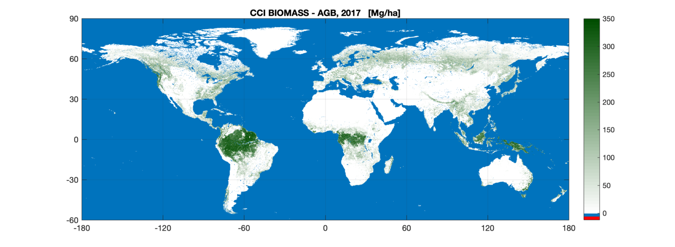
The first of a series of global maps aimed at quantifying change in carbon stored as biomass across the world’s forests and shrublands has been released today by ESA’s Climate Change Initiative at COP25 – the United Nation Climate Change Conference currently taking place in Madrid.
Nové číslo GaKO
6.12.2019 14:00
ÚGKK SR
Nové číslo časopisu Geodetického a Kartografického Obzoru 12/2019
20191206-GaKO-12-2019
6.12.2019 13:58 ČÚZK - předpisy a opatření Český úřad zeměměřický a katastrální zveřejnil novou aktualitu: Aktuální číslo Geodetického a kartografického obzoru (12/2019) je k dispozici ke stažení.GaKO 12/2019
6.12.2019 12:42 GaKO GaKO 12/2019 RADĚJ, K.–LECHNER, J.–DRBAL, A.: Výzkumný ústav geodetický, topografický a kartografický, v. v. i. – 65 let jeho existence IMRIŠEK, M.: Implementácia navigačného družicového systému Galileo do spracovania Európskej permanentnej sieteGaKO 12/2019
6.12.2019 12:42 GaKO GaKO 12/2019 RADĚJ, K.–LECHNER, J.–DRBAL, A.: Výzkumný ústav geodetický, topografický a kartografický, v. v. i. – 65 let jeho existence IMRIŠEK, M.: Implementácia navigačného družicového systému Galileo do spracovania Európskej permanentnej sieteGaKO 12/2019
6.12.2019 12:42 GaKO GaKO 12/2019 RADĚJ, K.–LECHNER, J.–DRBAL, A.: Výzkumný ústav geodetický, topografický a kartografický, v. v. i. – 65 let jeho existence IMRIŠEK, M.: Implementácia navigačného družicového systému Galileo do spracovania Európskej permanentnej sieteGaKO 12/2019
6.12.2019 12:38 GaKO GaKO 12/2019 RADĚJ, K.–LECHNER, J.–DRBAL, A.: Výzkumný ústav geodetický, topografický a kartografický, v. v. i. – 65 let jeho existence IMRIŠEK, M.: Implementácia navigačného družicového systému Galileo do spracovania Európskej permanentnej sietePerformance Cockpit takes overall prize at Galileo Masters 2019
6.12.2019 12:23 European GNSS Agency
The Aeroficial Intelligence system leverages Galileo positioning and EGNOS augmentation in data-driven solutions that increase operational efficiency and considerably reduce fuel consumption in the aviation industry. In this way, it addresses a pressing challenge in an industry that is set to see the world’s aircraft fleet more than double in the next 20 years.
Galileo-Copernicus Synergy Challenge
In addition to the overall prize, 26 more prizes were awarded at this year’s Galileo Masters, including the Galileo-Copernicus Synergy Challenge. This award went to Xylene, an app that revolutionises the way timber is supplied to the market. The concept behind the Xylene app is to document every step of the timber supply chain, from the forest to the final product. This unique Source-2-Store process not only enables supply chain tracking, but also validates the origin of the wood as certified or not.
Read this: uMaze takes Accuracy Matters prize in Galileo Innovation Challenge
By automatically registering GNSS position and consignment volume data, matching this with the individual process steps and generating real-time reports in the event of violations, the app prevents illegal wood from entering the supply chain and reduces fraud. The end customer, in addition to each partner along the supply chain, can visualise the entire supply chain using QR codes. Leveraging Galileo positioning and Copernicus imagery, the app offers the best combination of reliability, feasibility and cost.
Promoting innovation
“Promoting innovation has always been a key goal for the GSA. During our 11 years of partnership with the Galileo Masters, the competition has been an important generator of new market-driven applications and services based on Galileo’s differentiators, and this year has been no different,” said GSA Executive Director Carlo des Dorides. “I would like to congratulate all of the participants in this year’s competition and particularly the winners for their innovative use of Galileo,” he said.
Idea of the year
In the ‘Idea of the Year’ category, the winner was CX-GEODRON – a radar-based drone payload for underground detection. The CX-Geodron project is developing a drone payload based on radar equipment and post-processing techniques for geo-referenced data to complement, and sometimes replace, LiDAR laser technologies and take the next step in underground detection applications.
And this: First Galileo-enabled autonomous vehicle successfully demonstrated
The use of drones in non-destructive inspection applications has proven feasible and effective, making this a field with very important growth potential. The accuracy, stability, and flight time of drone platforms have significantly improved and the feasibility of using Synthetic Aperture Radar (SAR) systems in different applications related to terrestrial observation has been demonstrated. What’s more, the detection of buried objects is also continuing to improve with regard to resolution and depth.
Start-up of the Year
The winner in the ‘Start-up of the Year’ category - PODIS (POst DIstress Signal) - is a client-server IoT solution-as-a-service for automatic crash notification (ACN). The solution’s unique selling point is its patented underlying methodology for filtering out false alarms. Other ACN systems try to filter out false alarms on the client side, which is difficult due to varying vehicle behaviour, while PODIS does this on the server side.
In this way, PODIS maximises the use of the “golden hour”. This is a trauma term that refers to the first hour from the moment a car accident occurs. The goal of trauma professionals is to get injured people to a hospital within one hour to increase their chances of survival.
The Galileo Masters annually awards the best services, products, and business ideas using satellite navigation in everyday life, fostering the development of market-driven applications and identifying the most outstanding business cases related to GNSS, in line with the EU Space Strategy.
Media note: This feature can be republished without charge provided the European GNSS Agency (GSA) is acknowledged as the source at the top or the bottom of the story. You must request permission before you use any of the photographs on the site. If you republish, we would be grateful if you could link back to the GSA website (http://www.gsa.europa.eu).
Performance Cockpit takes overall prize at Galileo Masters 2019
6.12.2019 12:23 European GNSS AgencyThe Aeroficial Intelligence system leverages Galileo positioning and EGNOS augmentation in data-driven solutions that increase operational efficiency and considerably reduce fuel consumption in the aviation industry. In this way, it addresses a pressing challenge in an industry that is set to see the world’s aircraft fleet more than double in the next 20 years.
Galileo-Copernicus Synergy Challenge
In addition to the overall prize, 26 more prizes were awarded at this year’s Galileo Masters, including the Galileo-Copernicus Synergy Challenge. This award went to Xylene, an app that revolutionises the way timber is supplied to the market. The concept behind the Xylene app is to document every step of the timber supply chain, from the forest to the final product. This unique Source-2-Store process not only enables supply chain tracking, but also validates the origin of the wood as certified or not.
Read this: uMaze takes Accuracy Matters prize in Galileo Innovation Challenge
By automatically registering GNSS position and consignment volume data, matching this with the individual process steps and generating real-time reports in the event of violations, the app prevents illegal wood from entering the supply chain and reduces fraud. The end customer, in addition to each partner along the supply chain, can visualise the entire supply chain using QR codes. Leveraging Galileo positioning and Copernicus imagery, the app offers the best combination of reliability, feasibility and cost.
Promoting innovation
“Promoting innovation has always been a key goal for the GSA. During our 11 years of partnership with the Galileo Masters, the competition has been an important generator of new market-driven applications and services based on Galileo’s differentiators, and this year has been no different,” said GSA Executive Director Carlo des Dorides. “I would like to congratulate all of the participants in this year’s competition and particularly the winners for their innovative use of Galileo,” he said.
Idea of the year
In the ‘Idea of the Year’ category, the winner was CX-GEODRON – a radar-based drone payload for underground detection. The CX-Geodron project is developing a drone payload based on radar equipment and post-processing techniques for geo-referenced data to complement, and sometimes replace, LiDAR laser technologies and take the next step in underground detection applications.
And this: First Galileo-enabled autonomous vehicle successfully demonstrated
The use of drones in non-destructive inspection applications has proven feasible and effective, making this a field with very important growth potential. The accuracy, stability, and flight time of drone platforms have significantly improved and the feasibility of using Synthetic Aperture Radar (SAR) systems in different applications related to terrestrial observation has been demonstrated. What’s more, the detection of buried objects is also continuing to improve with regard to resolution and depth.
Start-up of the Year
The winner in the ‘Start-up of the Year’ category - PODIS (POst DIstress Signal) - is a client-server IoT solution-as-a-service for automatic crash notification (ACN). The solution’s unique selling point is its patented underlying methodology for filtering out false alarms. Other ACN systems try to filter out false alarms on the client side, which is difficult due to varying vehicle behaviour, while PODIS does this on the server side.
In this way, PODIS maximises the use of the “golden hour”. This is a trauma term that refers to the first hour from the moment a car accident occurs. The goal of trauma professionals is to get injured people to a hospital within one hour to increase their chances of survival.
The Galileo Masters annually awards the best services, products, and business ideas using satellite navigation in everyday life, fostering the development of market-driven applications and identifying the most outstanding business cases related to GNSS, in line with the EU Space Strategy.
Media note: This feature can be republished without charge provided the European GNSS Agency (GSA) is acknowledged as the source at the top or the bottom of the story. You must request permission before you use any of the photographs on the site. If you republish, we would be grateful if you could link back to the GSA website (http://www.gsa.europa.eu).
Performance Cockpit takes overall prize at Galileo Masters 2019
6.12.2019 12:23 European GNSS AgencyPerformance Cockpit, a business intelligence system from the start-up Aeroficial Intelligence, was named the 2019 Overall Winner of the Galileo Masters international innovation competition during its awards ceremony, held as part of European Space Week on 4 December in Helsinki, Finland.
The Aeroficial Intelligence system leverages Galileo positioning and EGNOS augmentation in data-driven solutions that increase operational efficiency and considerably reduce fuel consumption in the aviation industry. In this way, it addresses a pressing challenge in an industry that is set to see the world’s aircraft fleet more than double in the next 20 years.
Galileo-Copernicus Synergy Challenge
In addition to the overall prize, 26 more prizes were awarded at this year’s Galileo Masters, including the Galileo-Copernicus Synergy Challenge. This award went to Xylene, an app that revolutionises the way timber is supplied to the market. The concept behind the Xylene app is to document every step of the timber supply chain, from the forest to the final product. This unique Source-2-Store process not only enables supply chain tracking, but also validates the origin of the wood as certified or not.
Read this: uMaze takes Accuracy Matters prize in Galileo Innovation Challenge
By automatically registering GNSS position and consignment volume data, matching this with the individual process steps and generating real-time reports in the event of violations, the app prevents illegal wood from entering the supply chain and reduces fraud. The end customer, in addition to each partner along the supply chain, can visualise the entire supply chain using QR codes. Leveraging Galileo positioning and Copernicus imagery, the app offers the best combination of reliability, feasibility and cost.
Promoting innovation
“Promoting innovation has always been a key goal for the GSA. During our 11 years of partnership with the Galileo Masters, the competition has been an important generator of new market-driven applications and services based on Galileo’s differentiators, and this year has been no different,” said GSA Executive Director Carlo des Dorides. “I would like to congratulate all of the participants in this year’s competition and particularly the winners for their innovative use of Galileo,” he said.
Idea of the year
In the ‘Idea of the Year’ category, the winner was CX-GEODRON – a radar-based drone payload for underground detection. The CX-Geodron project is developing a drone payload based on radar equipment and post-processing techniques for geo-referenced data to complement, and sometimes replace, LiDAR laser technologies and take the next step in underground detection applications.
And this: First Galileo-enabled autonomous vehicle successfully demonstrated
The use of drones in non-destructive inspection applications has proven feasible and effective, making this a field with very important growth potential. The accuracy, stability, and flight time of drone platforms have significantly improved and the feasibility of using Synthetic Aperture Radar (SAR) systems in different applications related to terrestrial observation has been demonstrated. What’s more, the detection of buried objects is also continuing to improve with regard to resolution and depth.
Start-up of the Year
The winner in the ‘Start-up of the Year’ category - PODIS (POst DIstress Signal) - is a client-server IoT solution-as-a-service for automatic crash notification (ACN). The solution’s unique selling point is its patented underlying methodology for filtering out false alarms. Other ACN systems try to filter out false alarms on the client side, which is difficult due to varying vehicle behaviour, while PODIS does this on the server side.
In this way, PODIS maximises the use of the “golden hour”. This is a trauma term that refers to the first hour from the moment a car accident occurs. The goal of trauma professionals is to get injured people to a hospital within one hour to increase their chances of survival.
The Galileo Masters annually awards the best services, products, and business ideas using satellite navigation in everyday life, fostering the development of market-driven applications and identifying the most outstanding business cases related to GNSS, in line with the EU Space Strategy.
Media note: This feature can be republished without charge provided the European GNSS Agency (GSA) is acknowledged as the source at the top or the bottom of the story. You must request permission before you use any of the photographs on the site. If you republish, we would be grateful if you could link back to the GSA website (http://www.gsa.europa.eu).
Omezení provozu 31.12.2019
6.12.2019 11:56 ČÚZK - předpisy a opatření Katastrální úřad pro Jihočeský kraj zveřejnil novou aktualitu: Dovolujeme si upozornit, že v úterý dne 31.12.2019 budou všechna katastrální pracoviště Katastrálního úřadu pro Jihočeský kraj otevřena pro veřejnost pouze v době od 8:00 do 13:00 hodin.Děkujeme za pochopení.
Ing. Jiří Vrána
ředitel úřadu
Omezení provozu 31.12.2019
6.12.2019 11:56 ČÚZK /Urady/Katastralni-urady/Katastralni-urady/Katastralni-urad-pro-Jihocesky-kraj/O-uradu/Aktuality/Omezeni-provozu-31-12-2019Účastnili jsme se Amsterdam Drone Week a hlavně EASA High Level Conference on Drones 2019
6.12.2019 11:19 UpVisionNáročný týden v Amsterdamu je u konce. 🙂 Účastnili jsme se ještě Amsterdam Drone Week a hlavně EASA High Level Conference on Drones 2019. Na fotce je Jakub s projektovým manažerem EASA, který má na starost novou U-Space regulaci, kterou společně dlouhodobě konzultujeme. Náročný týden v Amsterdamu je u konce. 🙂 Účastnili jsme se ještě Amsterdam Drone Week […]
The post Účastnili jsme se Amsterdam Drone Week a hlavně EASA High Level Conference on Drones 2019 appeared first on Upvision.
Referent v oddělení aktualizace KN
6.12.2019 10:40 ČÚZK - volná místa Katastrální úřad pro Liberecký kraj - Katastrální pracoviště Liberec vypisuje výběrové řízení na místo Referent v oddělení aktualizace KNReferent v oddělení aktualizace KN
6.12.2019 10:40 ČÚZK /Urady/Katastralni-urady/Katastralni-urady/Katastralni-urad-pro-Liberecky-kraj/Uredni-deska/Oznameni-a-jina-uredni-sdeleni/Volna-mista/Referent-v-oddeleni-aktualizace-KNReferent v oddělení aktualizace KN
6.12.2019 10:40 ČÚZK - předpisy a opatření Katastrální úřad pro Liberecký kraj - Katastrální pracoviště Liberecvypisuje výběrové řízení na místo
Referent v oddělení aktualizace KN