


![]()

zprávy
zdroje zpráv:Satlab Geosolutions AB Participated at Intergeo 2019 in Stuttgart, Germany
11.10.2019 10:14 Satlab GeosolutionsSweden, 9 October 2019 SatLab Geosolutions AB participated in the three-day Intergeo exhibition and conference. This year, Intergeo is held in Stuttgart, a city famous for its automotive industry. SatLab Geosolutions showcased new technology and solutions such as Machine Control, Monitoring, Indoor Positioning and UAV Solutions along with other traditional products at the 25th […]
The post Satlab Geosolutions AB Participated at <br>Intergeo 2019 in Stuttgart, Germany appeared first on Satlab – Global Satellite Positioning Solutions.
Satlab Geosolutions AB Participated at Intergeo 2019 in Stuttgart, Germany
11.10.2019 10:14 Satlab GeosolutionsSweden, 9 October 2019 SatLab Geosolutions AB participa […]
The post Satlab Geosolutions AB Participated at <br>Intergeo 2019 in Stuttgart, Germany appeared first on Satlab – Global Satellite Positioning Solutions.
Satlab Geosolutions AB Participated at Intergeo 2019 in Stuttgart, Germany
11.10.2019 10:14 Satlab GeosolutionsSweden, 9 October 2019 Satlab Geosolutions AB participated in the three-day Intergeo exhibition and conference. This year, Intergeo is held in Stuttgart, a city famous for its automotive industry. Satlab Geosolutions showcased new technology and solutions such as Machine Control, Monitoring, Indoor Positioning and UAV Solutions along with other traditional products at […]
The post Satlab Geosolutions AB Participated at Intergeo 2019 in Stuttgart, Germany appeared first on Satlab – Global Satellite Positioning Solutions.
Satlab Geosolutions AB Participated at Intergeo 2019 in Stuttgart, Germany
11.10.2019 10:14 Satlab GeosolutionsSweden, 9 October 2019 Satlab Geosolutions AB participated in the three-day Intergeo exhibition and conference. This year, Intergeo is held in Stuttgart, a city famous for its automotive industry. Satlab Geosolutions showcased new technology and solutions such as Machine Control, Monitoring, Indoor Positioning and UAV Solutions along with other traditional products at the […]
The post Satlab Geosolutions AB Participated at Intergeo 2019 in Stuttgart, Germany appeared first on Satlab – Global Satellite Positioning Solutions.
Lake Natron
11.10.2019 10:05 ESA Observing the Earth
Earth observation image of the week: Copernicus Sentinel-2 takes us over two saline lakes in East Africa
Earth from Space
11.10.2019 10:05 ESA Observing the Earth
In this edition, we explore two saline lakes in East Africa with Copernicus Sentinel-2
Earth from Space: Lake Natron
11.10.2019 10:00 ESA Observing the Earth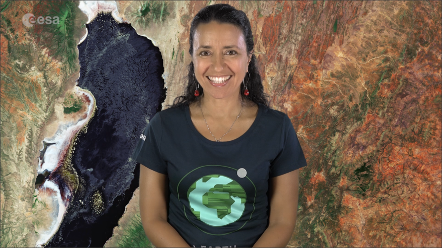 Video:
00:02:18
Video:
00:02:18
In this week's edition of the Earth from Space programme, the Copernicus Sentinel-2 mission takes us over two saline lakes in East Africa.
See also Lake Natron, Tanzania to download the image.
Lake Natron, Tanzania
11.10.2019 10:00 ESA Observing the Earth Image:
The Copernicus Sentinel-2 mission takes us over two saline lakes in East Africa: the larger Lake Natron in northern Tanzania and the smaller Lake Magadi, just over the border in Kenya.
Lake Natron is around 60 km long and is fed mainly by the Ewaso Ng'iro River. Despite its dark colour in this image, Lake Natron is often bright red owing to the presence of microorganisms that feed on the salts of the water.
The saline waters make the lake inhospitable for many plants and animals, yet the surrounding salt water marshes are a surprising habitat for flamingos. In fact, the lake is home to the highest concentrations of lesser and greater flamingos in East Africa, where they feed on spirulina – a green algae with red pigments.
The extinct Gelai Volcano, standing at 2942 m tall, is visible southeast of the lake.
The pink-coloured waters of Lake Magadi can also be seen at the top of the image. The lake is over 30 km long and has a notably high salt content, and in some places the salt is up to 40 metres thick. The mineral trona can also be found in the lake’s waters. This mineral is collected and used for glass manufacturing, fabric dyeing and paper production.
Copernicus Sentinel-2 is a two-satellite mission to supply the coverage and data delivery needed for Europe’s Copernicus programme. The mission’s frequent revisits over the same area and high spatial resolution allow changes in inland water bodies to be closely monitored.
This image, which was captured on 3 February 2019, is also featured on the Earth from Space video programme.
Earth from Space: Lake Natron
11.10.2019 10:00 ESA Observing the Earth
Video:
00:02:18
In this week's edition of the Earth from Space programme, the Copernicus Sentinel-2 mission takes us over two saline lakes in East Africa.
See also Lake Natron, Tanzania to download the image.
Podzimní Olomouc (POOL) 2019
11.10.2019 9:53 Katedra geoinformatiky UP OlomoucTaké letos se uskuteční tradiční týden výuky expertů z praxe – Podzimní Olomouc, a to ve dnech 21. – 25. 10. 2019. Více informací zde.
The post Podzimní Olomouc (POOL) 2019 appeared first on Katedra geoinformatiky.
služební místo rada/odborný rada - právník
11.10.2019 9:23 ČÚZK - předpisy a opatření Katastrální úřad pro hlavní město Prahu - Katastrální pracoviště Praha zveřejnil novou aktualitu: Ředitel úřadu vyhlašuje výběrové řízení na služební místo:rada/odborný rada - právník
služební místo rada/odborný rada - právník
11.10.2019 9:23 ČÚZK /Urady/Katastralni-urady/Katastralni-urady/Katastralni-urad-pro-hlavni-mesto-Prahu/O-uradu/Aktuality/sluzebni-misto-rada-odborny-rada-pravnikodborný referent – poskytování informací KN
11.10.2019 9:23 ČÚZK /Urady/Katastralni-urady/Katastralni-urady/Katastralni-urad-pro-hlavni-mesto-Prahu/O-uradu/Aktuality/sluzebni-misto-rada-odborny-rada-pravnikodborný referent – poskytování informací KN
11.10.2019 9:23 ČÚZK - předpisy a opatření Katastrální úřad pro hlavní město Prahu - Katastrální pracoviště Praha zveřejnil novou aktualitu: Ředitel úřadu vyhlašuje výběrové řízení na služební místo:odborný referent – poskytování informací KN
služební místo rada/odborný rada - právník
11.10.2019 9:23 ČÚZK - předpisy a opatření Katastrální úřad pro hlavní město Prahu - Katastrální pracoviště Praha zveřejnil novou aktualitu: Ředitel úřadu vyhlašuje výběrové řízení na služební místo:rada/odborný rada - právník
služební místo rada/odborný rada - právník
11.10.2019 9:20 ČÚZK /Urady/Katastralni-urady/Katastralni-urady/Katastralni-urad-pro-hlavni-mesto-Prahu/Uredni-deska/Oznameni-a-jina-uredni-sdeleni/Volna-mista/sluzebni-misto-rada-odborny-rada-pravnikslužební místo rada/odborný rada - právník
11.10.2019 9:20 ČÚZK - volná místa Katastrální úřad pro hlavní město Prahu - Katastrální pracoviště Praha vypisuje výběrové řízení na místo služební místo rada/odborný rada - právníkslužební místo rada/odborný rada - právník
11.10.2019 9:20 ČÚZK - předpisy a opatření Katastrální úřad pro hlavní město Prahu - Katastrální pracoviště Prahavypisuje výběrové řízení na služební místo
služební místo rada/odborný rada - právník
odborný referent – poskytování informací KN
11.10.2019 9:20 ČÚZK - volná místa Katastrální úřad pro hlavní město Prahu - Katastrální pracoviště Praha vypisuje výběrové řízení na místo odborný referent – poskytování informací KNslužební místo rada/odborný rada - právník
11.10.2019 9:20 ČÚZK - předpisy a opatření Katastrální úřad pro hlavní město Prahu - Katastrální pracoviště Prahavypisuje výběrové řízení na místo
služební místo rada/odborný rada - právník
odborný referent – poskytování informací KN
11.10.2019 9:20 ČÚZK /Urady/Katastralni-urady/Katastralni-urady/Katastralni-urad-pro-hlavni-mesto-Prahu/Uredni-deska/Oznameni-a-jina-uredni-sdeleni/Volna-mista/sluzebni-misto-rada-odborny-rada-pravnikodborný referent – poskytování informací KN
11.10.2019 9:20 ČÚZK - předpisy a opatření Katastrální úřad pro hlavní město Prahu - Katastrální pracoviště Prahavypisuje výběrové řízení na služební místo
odborný referent – poskytování informací KN
Share Your Data with the Esri GIS Community (ArcNews Online)
11.10.2019 9:00 GISCafe.com Webcasts-WebinarsThe Race to Make a High-Resolution Map of the World’s Oceans (ArcUser Online)
11.10.2019 9:00 GISCafe.com Webcasts-WebinarsPasadena Tournament of Roses Manages Real-Time Situational Awareness (ArcNews Online)
11.10.2019 9:00 GISCafe.com Webcasts-WebinarsSanjay Gangal interviews Oleg Ponfilenok from COEX at Intergeo 2019 CONFERENCE
11.10.2019 9:00 GISCafe.com Webcasts-WebinarsRESPEC Releases GeoSequel® 2.15 With LabTools
10.10.2019 22:41 GISCafe.com Webcasts-Webinars Software Makes Smart Mines Even SmarterRAPID CITY, S.D., Oct. 10, 2019 — (PRNewswire) —
RAPID CITY, S.D., Oct. 10, 2019 …
SAM, LLC First in North America to Deploy Advanced Aerial Scanning Technology
10.10.2019 22:41 GISCafe.com Webcasts-Webinars SAM, LLC, a leader in providing geospatial data solutions, will be the first company in North America to acquire and deploy the most recent major …Beyond Limits CEO AJ Abdallat Joins Board of Advisors for the Center for Autonomous Systems and Technologies (CAST) at Caltech
10.10.2019 17:15 GISCafe.com Webcasts-Webinars Advisory relationship with Caltech/JPL includes working at the cutting edge of AI technologyGLENDALE, Calif., Oct. 10, 2019 — (PRNewswire) …
Typhoon Hagibis
10.10.2019 16:45 ESA Observing the Earth
Japan braces for strong winds and torrential rain as Typhoon Hagibis approaches
Typhoon Hagibis
10.10.2019 16:45 ESA Observing the Earth
Japan braces for strong winds and torrential rain as Typhoon Hagibis approaches
Typhoon Hagibis
10.10.2019 16:45 ESA Observing the Earth
Japan braces for strong winds and torrential rain as Typhoon Hagibis approaches
URISA Leaders Recognized at GIS-Pro 2019
10.10.2019 15:35 GISCafe.com Webcasts-Webinars Des Plaines, IL (October 9, 2019) Nearly 500 GIS professionals - from 42 states (plus Puerto Rico and the District of …20191010-VŘ Metodik/metodička bezpečnosti
10.10.2019 15:02 ČÚZK - předpisy a opatření Český úřad zeměměřický a katastrální zveřejnil novou aktualitu: Oznámení o vyhlášení výběrového řízení na obsazení služebního místa Metodik/metodička bezpečnosti.20191010-VŘ Metodik/metodička bezpečnosti
10.10.2019 15:02 ČÚZK /Aktuality-resort/2019/20191010-VR-Metodik-metodicka-bezpecnostiLuca Parmitano se chystá na kosmickou vycházku
10.10.2019 13:14 Český Kosmický PortálKosmonaut ESA Luca Parmitano se připravuje na první výstup do otevřeného prostoru ve skafandru v rámci své mise Beyond.
Získali jsme certifikát společensky odpovědné firmy
10.10.2019 11:26 HrdličkaTento projekt můžete podpořit také Vaše firma. Více se dozvíte na stránkách www.remobil.cz
The post Získali jsme certifikát společensky odpovědné firmy appeared first on HRDLIČKA spol. s r.o. - komplexní služby v oblasti geodézie.
Mapová aplikace ÚAP - aktualizace
10.10.2019 10:15 Jihočeský kraj Mapová aplikace Územně analytické podklady byla aktualizována k 7.10.2019.EUTELSAT 5 West B successfully launched with EGNOS payload
10.10.2019 9:59 European GNSS Agency
The EUTELSAT 5 West B satellite was successfully launched on a Proton M/Breeze M launch vehicle from Pad 39 at Baikonur Cosmodrome, Kazakhstan, at 12.17 CET on Wednesday 9 October. Hosting the GEO-3 payload of the European Geostationary Navigation Overlay System (EGNOS), the satellite will support EGNOS V3 - the next generation of the EGNOS programme.
The satellite separated from the launch vehicle 15 hours 36 minutes after the launch and testing of the EGNOS GEO-3 payload should start within 2 weeks after separation.
EGNOS V3 will augment both GPS and Galileo in the L1 and L5 bands. Furthermore, it will provide additional satellite-based augmentation system (SBAS) service capabilities through a new SBAS channel on L5 and will deliver increased EGNOS service availability within and beyond the EU Member States, supporting a growing number of users.
“This new EGNOS payload will be key in developing and testing EGNOS V3 - the latest evolution of the system. This launch is also a first decisive step in the implementation of the EGNOS Space Segment roadmap defined by the GSA. Together with the next GEO-4 payload, which is under procurement, it will allow the programme to ensure a smooth transition to EGNOS V3 operations, with swaps between GEOs ensuring that the programme provides adequate service robustness to its increasing user base,” said EGNOS Services Programme Manager Jean-Marc Piéplu.
Read this: Airbus awarded EGNOS V3 contract
Reinforced security
The next generation of the EGNOS programme will also benefit from reinforced security, which will increase the robustness of EGNOS services against potential threats. EGNOS V3 will be made available in 2024 and will augment Galileo signals from 2025.
“This successful launch is an important milestone for the EU space programmes EGNOS and Galileo. It is carrying to orbit the foundation stone of the next generation of EGNOS, which will improve and expand EGNOS service provision and enable the programme to augment signals from Galileo satellites, bringing EGNSS full circle,” European GNSS Agency (GSA) Executive Director Carlo des Dorides said.
Supporting economic growth
The current EGNOS generation – EGNOS V2 – is already improving positioning accuracy and supporting applications in a range of sectors – from precision agriculture and shipping to the aviation sector. To learn more about the role of EGNOS in aviation, watch our new EGNOS for Aviation video here.
And this: Europe’s economy is increasingly dependent on space - ITRE committee hears
“Space plays an increasingly important role in the lives of Europeans, with about 10% of Europe’s economy and large numbers of jobs in various sectors dependent on space services. This launch implemented by EUTELSAT through their 5 West B satellite, and the subsequent evolution of EGNOS, will ensure that the European programmes Galileo and EGNOS continue to support economic growth in Europe and deliver services to European citizens,” said GSA Chief Operating Officer Pascal Claudel.
About EGNOS
EGNOS is Europe's regional satellite-based augmentation system (SBAS). It is currently used to improve the performance of GPS and will augment Galileo from 2025 onwards. EGNOS was deployed to provide safety of life navigation services to aviation, maritime and land-based users.
EGNOS uses GNSS measurements taken by reference stations deployed mainly across Europe and North Africa. These measurements are transferred to a central computing centre where differential corrections and integrity messages are calculated. These calculations are then broadcast over the covered area using geostationary satellites that serve as an augmentation, or overlay, to the original GNSS message.
The information provided by EGNOS improves the accuracy and reliability of GNSS positioning information while also providing a crucial integrity message. In addition, EGNOS also transmits an accurate time signal.
Media note: This feature can be republished without charge provided the European GNSS Agency (GSA) is acknowledged as the source at the top or the bottom of the story. You must request permission before you use any of the photographs on the site. If you republish, we would be grateful if you could link back to the GSA website (http://www.gsa.europa.eu).
EUTELSAT 5 West B successfully launched with EGNOS payload
10.10.2019 9:59 European GNSS AgencyThe EUTELSAT 5 West B satellite was successfully launched on a Proton M/Breeze M launch vehicle from Pad 39 at Baikonur Cosmodrome, Kazakhstan, at 12.17 CET on Wednesday 9 October. Hosting the GEO-3 payload of the European Geostationary Navigation Overlay System (EGNOS), the satellite will support EGNOS V3 - the next generation of the EGNOS programme.
The satellite separated from the launch vehicle 15 hours 36 minutes after the launch and testing of the EGNOS GEO-3 payload should start within 2 weeks after separation.
EGNOS V3 will augment both GPS and Galileo in the L1 and L5 bands. Furthermore, it will provide additional satellite-based augmentation system (SBAS) service capabilities through a new SBAS channel on L5 and will deliver increased EGNOS service availability within and beyond the EU Member States, supporting a growing number of users.
“This new EGNOS payload will be key in developing and testing EGNOS V3 - the latest evolution of the system. This launch is also a first decisive step in the implementation of the EGNOS Space Segment roadmap defined by the GSA. Together with the next GEO-4 payload, which is under procurement, it will allow the programme to ensure a smooth transition to EGNOS V3 operations, with swaps between GEOs ensuring that the programme provides adequate service robustness to its increasing user base,” said EGNOS Services Programme Manager Jean-Marc Piéplu.
Read this: Airbus awarded EGNOS V3 contract
Reinforced security
The next generation of the EGNOS programme will also benefit from reinforced security, which will increase the robustness of EGNOS services against potential threats. EGNOS V3 will be made available in 2024 and will augment Galileo signals from 2025.
“This successful launch is an important milestone for the EU space programmes EGNOS and Galileo. It is carrying to orbit the foundation stone of the next generation of EGNOS, which will improve and expand EGNOS service provision and enable the programme to augment signals from Galileo satellites, bringing EGNSS full circle,” European GNSS Agency (GSA) Executive Director Carlo des Dorides said.
Supporting economic growth
The current EGNOS generation – EGNOS V2 – is already improving positioning accuracy and supporting applications in a range of sectors – from precision agriculture and shipping to the aviation sector. To learn more about the role of EGNOS in aviation, watch our new EGNOS for Aviation video here.
And this: Europe’s economy is increasingly dependent on space - ITRE committee hears
“Space plays an increasingly important role in the lives of Europeans, with about 10% of Europe’s economy and large numbers of jobs in various sectors dependent on space services. This launch implemented by EUTELSAT through their 5 West B satellite, and the subsequent evolution of EGNOS, will ensure that the European programmes Galileo and EGNOS continue to support economic growth in Europe and deliver services to European citizens,” said GSA Chief Operating Officer Pascal Claudel.
About EGNOS
EGNOS is Europe's regional satellite-based augmentation system (SBAS). It is currently used to improve the performance of GPS and will augment Galileo from 2025 onwards. EGNOS was deployed to provide safety of life navigation services to aviation, maritime and land-based users.
EGNOS uses GNSS measurements taken by reference stations deployed mainly across Europe and North Africa. These measurements are transferred to a central computing centre where differential corrections and integrity messages are calculated. These calculations are then broadcast over the covered area using geostationary satellites that serve as an augmentation, or overlay, to the original GNSS message.
The information provided by EGNOS improves the accuracy and reliability of GNSS positioning information while also providing a crucial integrity message. In addition, EGNOS also transmits an accurate time signal.
Media note: This feature can be republished without charge provided the European GNSS Agency (GSA) is acknowledged as the source at the top or the bottom of the story. You must request permission before you use any of the photographs on the site. If you republish, we would be grateful if you could link back to the GSA website (http://www.gsa.europa.eu).
Geotrain Cup 2019
10.10.2019 9:45 HrdličkaLetošní 5. ročník byl unikátní díky počáteční mlze, která zahalila hřiště do bílé peřiny a start turnaje byl nejistý. Sluníčko však přeci jen mělo snahu vystoupat a mlha se postupně ztratila. Hřiště v České Lípě je proslulé pohodovou atmosférou, a i tentokráte tomu nebylo jinak. Letošní výsledky nebyly tak ohromující jako loni, ale i přesto spousta... View Article
The post Geotrain Cup 2019 appeared first on HRDLIČKA spol. s r.o. - komplexní služby v oblasti geodézie.
Sanjay Gangal interviews Pascal Schichor, Sales Director from European Space Imaging at Intergeo 2019 CONFERENCE
10.10.2019 9:00 GISCafe.com Webcasts-WebinarsFourth of July Fireworks Patrols Get New Spark from GIS (ArcNews Online)
10.10.2019 9:00 GISCafe.com Webcasts-WebinarsLead'Air Inc. has announced innovative new aerial survey multi-focal lenses at the 2019 INTERGEO in Stuttgart, Germany.
10.10.2019 1:28 GISCafe.com Webcasts-Webinars October 09, 2019 -- The GSD, Ground Sample Distance (or resolution), is the key specification of any digital aerial photo mapping project. For a …Maxar Opens New Facility in St. Louis to Support Growth in U.S. National Geospatial-Intelligence Agency Programs
10.10.2019 1:28 GISCafe.com Webcasts-Webinars WESTMINSTER, Colo. — (BUSINESS WIRE) — October 9, 2019 —Maxar Technologies (NYSE:MAXR) (TSX:MAXR), a trusted partner and …
BIM Day 2019
9.10.2019 22:22 Asociace podnikatelů v geomatice Dne 8. října se v Praze uskutečnila konference BIM Day 2019, kterou každoročně pořádá Odborná rada pro BIM. APG na konferenci reprezentoval Jan Floriánek, vedoucí pracovní skupiny BIM, s přednáškou „BIM &Geomatika – na co se zapomíná“. Více informací naleznete na www.bimday.cz.Open doctoral position on Visual Analytics of mobile behaviour data – Department of Geography – University of Zurich
9.10.2019 19:47 The Geographic Information Visualization & Analysis group in the Departement of Geography, University of Zurichis recruiting for a doctoral position in the field of Visual Analytics of mobile behaviour data.More information can be found here: Doctoral research assistant position: Visual analytics of mobile behaviour dataPlease distribute among your network. Apologies for any cross-postings.Kind regards,Tumasch—————————————–Dr. Tumasch ReichenbacherSenior Lecturer Geographic […]HERE launches AI-based Live Sense SDK to keep drivers informed of unexpected road hazards
9.10.2019 18:21 GISCafe.com Webcasts-Webinars HERE Live Sense SDK turns devices with a front-facing camera into an intelligent vehicle sensor, benefitting drivers with little or no safety …Teranet & Nearmap Announce Partnership
9.10.2019 18:21 GISCafe.com Webcasts-Webinars TORONTO, Oct. 9, 2019 — (PRNewswire) —TORONTO, Oct. 9, 2019 /CNW/ - Teranet Inc., Canada's leader in the delivery and transformation …
Echodyne to Present on Countering Drones at APSA Public Safety Drone Expo
9.10.2019 18:21 GISCafe.com Webcasts-Webinars Leaders in High-Performance Radars for 3D Security to Speak at Important Industry EventCOLUMBUS, Ohio — (BUSINESS WIRE) — October 9, …
Dreyev Chooses HERE to Improve Driver Safety
9.10.2019 17:06 GISCafe.com Webcasts-Webinars New HERE Live Sense SDK Provides a More Complete Driver Safety Solution for Fleet Managers and Insurance Carriers Chicago, IL – HERE …Autodesk Unveils Robust New Features for BIM 360
9.10.2019 17:06 GISCafe.com Webcasts-Webinars Enhanced BIM 360 Layout app empowers construction teams to speed up layout workflows, and additional feature advancements aim to simplify daily …SSC increases capacity at Florida ground station – eight new antennas to support OneWeb's global satellite network
9.10.2019 12:43 GISCafe.com Webcasts-Webinars Swedish Space Corporation (SSC) has completed assembly and installation of eight new antennas in Clewiston, Florida. The antennas will be used for …Pozvánka na seminář Kartografická výročí 2019 [Knihovna geografie, byTopic]
9.10.2019 12:00 Katedra aplikované geoinformatiky a kartografie Přf UK Seminář se uskuteční 9. 10. 2019 v Brně.Účast na semináři Kartografická výročí 2019 [Knihovna geografie, byTopic]
9.10.2019 12:00 Katedra aplikované geoinformatiky a kartografie Přf UK Seminář se uskutečnil 9. 10. 2019 v Brně.Osobní automobil AUDI sedan A6 - 2.kolo
9.10.2019 10:47 ČÚZK /Urady/Katastralni-urady/Katastralni-urady/Katastralni-urad-pro-Karlovarsky-kraj/Nabidky-majetku/Osobni-automobil-AUDI-sedan-A6-2-koloOsobní automobil AUDI sedan A6 - 2.kolo
9.10.2019 10:47 ČÚZK - předpisy a opatřeníKatastrální úřad pro Karlovarský kraj nabízí nepotřebný majetek k odkupu. Jedná se o
Osobní automobil AUDI sedan A6 - 2.kolo
Osobní automobil AUDI A6 - 2.kolo
9.10.2019 10:45 ČÚZK - předpisy a opatřeníKatastrální úřad pro Karlovarský kraj nabízí nepotřebný majetek k odkupu. Jedná se o
Osobní automobil AUDI A6 - 2.kolo
Osobní automobil AUDI A6 - 2.kolo
9.10.2019 10:45 ČÚZK /Urady/Katastralni-urady/Katastralni-urady/Katastralni-urad-pro-Karlovarsky-kraj/Nabidky-majetku/Osobni-automobil-AUDI-A6-2-koloKartografická výročí 2019 - Odborný seminář ku příležitosti 450 let Fabriciovy mapy Moravy a 400 let Aretinovy mapy Čech
9.10.2019 10:00 Geografický ústav MUTermín konání: 9.10.2019 (10:00 - 15:30)
Místo konání: Moravský zemský archiv v Brně, Palachovo náměstí 723/1, 625 00 Brno
Pořádá: Česká kartografická společnost, Moravský zemský archiv v Brně, Geografický ústav PřF MU a Mapová sbírka PřF UK.
Přihlášky: zde
V letošním roce uplyne 450 let od vydání tzv. Fabriciovy mapy Moravy (1569), prvního samostatného zachycení území Moravy a také 400 let od vydání třetí nejstarší mapy Čech - Aretinovy (1619). U příležitosti se uskuteční odborný seminář v prostorách Moravského zemského archivu v Brně. V rámci semináře vystoupí odborníci na problematiku dějin kartografie a budou zpřístupněny originální tisky obou map. Unikátní zpřístupněné materiály pochází z depozitu Moravské galerie, Moravského zemského archivu a Mapové sbírky PřF UK. Pro účast na semináři je nutná registrace. Kapacita sálu je omezena.
Pavel Fabricius (1519, Lubaň, Horní Lužice - 1589, Vídeň)
Císařský lékař, dvorní falckrabí, astronom, profesor matematiky vídeňské univerzity a botanik zřejmě na objednávku moravských stavů pořídil první mapu Moravy s názvem Moravia marchionatus / Das Marggrafftumb Mähren. Jako první z map Českého území obsahuje geografickou síť na rámu a také značkový klíč.
Pavel Aretin z Ehrenfeldu (okolo 1570, Uherský Brod - okolo 1640)
Pražský měšťan vytvořil mapu Čech, která se později dočkala mnoha vydání v nizozemských a anglických atlasech.Tato mapa se také používala jako vojenská mapa během třicetileté války. Mapa nese název Regni Bohemia nova et exacta descriptio (Nový a přesný popis Království českého) vyšla v roce 1619 a také v roce 1632.
Kartografická výročí 2019
9.10.2019 10:00 Geografický ústav MUOdborný seminář ku příležitosti 450 let Fabriciovy mapy Moravy a 400 let Aretinovy mapy Čech
Termín konání: 9.10.2019 (10:00 - 15:30)
Místo konání: Moravský zemský archiv v Brně, Palachovo náměstí 723/1, 625 00 Brno
Pořádá: Česká kartografická společnost, Moravský zemský archiv v Brně, Geografický ústav PřF MU a Mapová sbírka PřF, UK.
Přihlášky:
https://docs.google.com/forms/d/e/1FAIpQLSec7jc7A4GriudiZDMdTJCpTSa1EC9m20QEHL6FuUGjMsKLbA/viewform?vc=0&c=0&w=1
Anotace:
V letošním roce uplyne 450 let od vydání tzv. Fabriciovy mapy Moravy (1569), prvního samostatného zachycení území Moravy a také 400 let od vydání třetí nejstarší mapy Čech - Aretinovy (1619). U příležitosti se uskuteční odborný seminář v prostorách Moravského zemského archivu v Brně. V rámci semináře vystoupí odborníci na problematiku dějin kartografie a budou zpřístupněny originální tisky obou map. Unikátní zpřístupněné materiály pochází z depozitu Moravské galerie, Moravského zemského archivu a Mapové sbírky PřF UK. Pro účast na semináři je nutná registrace. Kapacita sálu je omezena.
Pavel Fabricius (1519, Lubaň, Horní Lužice - 1589, Vídeň)
Císařský lékař, dvorní falckrabí, astronom, profesor matematiky vídeňské univerzity a botanik zřejmě na objednávku moravských stavů pořídil první mapu Moravy s názvem Moravia marchionatus / Das Marggrafftumb Mähren. Jako první z map Českého území obsahuje geografickou síť na rámu a také značkový klíč.
Pavel Aretin z Ehrenfeldu (okolo 1570 Uherský Brod - okolo 1640)
Pražský měšťan vytvořil mapu Čech, která se později dočkala mnoha vydání v nizozemských a anglických atlasech.Tato mapa se také používala jako vojenská mapa během třicetileté války. Mapa nese název Regni Bohemia nova et exacta descriptio (Nový a přesný popis Království českého) vyšla v roce 1619 a také v roce 1632.
Vedoucí oddělení právních vztahů k nemovitostem KP Teplice na Katastrálním úřadu pro Ústecký kraj
9.10.2019 9:52 ČÚZK - volná místa Katastrální úřad pro Ústecký kraj - Katastrální pracoviště Teplice vypisuje výběrové řízení na místo Vedoucí oddělení právních vztahů k nemovitostem KP Teplice na Katastrálním úřadu pro Ústecký krajVedoucí oddělení právních vztahů k nemovitostem KP Teplice na Katastrálním úřadu pro Ústecký kraj
9.10.2019 9:52 ČÚZK - předpisy a opatření Katastrální úřad pro Ústecký kraj - Katastrální pracoviště Teplicevypisuje výběrové řízení na místo
Vedoucí oddělení právních vztahů k nemovitostem KP Teplice na Katastrálním úřadu pro Ústecký kraj
Vedoucí oddělení právních vztahů k nemovitostem KP Teplice na Katastrálním úřadu pro Ústecký kraj
9.10.2019 9:52 ČÚZK /Urady/Katastralni-urady/Katastralni-urady/Katastralni-urad-pro-Ustecky-kraj/Uredni-deska/Oznameni-a-jina-uredni-sdeleni/Volna-mista/Vedouci-oddeleni-pravnich-vztahu-k-nemovitostem-KPRada/odborný rada – řízení o opravě chyby v SPI na Katastrálním pracovišti Nový Jičín Katastrálního
9.10.2019 9:25 ČÚZK /Urady/Katastralni-urady/Katastralni-urady/Katastralni-urad-pro-Moravskoslezsky-kraj/Uredni-deska/Oznameni-a-jina-uredni-sdeleni/Volna-mista/Rada-odborny-rada-–-rizeni-o-oprave-chyby-v-SPI-naRada/odborný rada – řízení o opravě chyby v SPI na Katastrálním pracovišti Nový Jičín Katastrálního
9.10.2019 9:25 ČÚZK - volná místa Katastrální úřad pro Moravskoslezský kraj - Katastrální pracoviště Nový Jičín vypisuje výběrové řízení na místo Rada/odborný rada – řízení o opravě chyby v SPI na Katastrálním pracovišti Nový Jičín KatastrálníhoRada/odborný rada – řízení o opravě chyby v SPI na Katastrálním pracovišti Nový Jičín Katastrálního
9.10.2019 9:25 ČÚZK - předpisy a opatření Katastrální úřad pro Moravskoslezský kraj - Katastrální pracoviště Nový Jičínvypisuje výběrové řízení na místo
Rada/odborný rada – řízení o opravě chyby v SPI na Katastrálním pracovišti Nový Jičín Katastrálního úřadu pro Moravskoslezský kraj
Vrchní referent/rada – obnova katastrálního operátu na Katastrálním pracovišti Třinec Katastrálního
9.10.2019 9:22 ČÚZK - volná místa Katastrální úřad pro Moravskoslezský kraj - Katastrální pracoviště Třinec vypisuje výběrové řízení na místo Vrchní referent/rada – obnova katastrálního operátu na Katastrálním pracovišti Třinec KatastrálníhoVrchní referent/rada – obnova katastrálního operátu na Katastrálním pracovišti Třinec Katastrálního
9.10.2019 9:22 ČÚZK - předpisy a opatření Katastrální úřad pro Moravskoslezský kraj - Katastrální pracoviště Třinecvypisuje výběrové řízení na místo
Vrchní referent/rada – obnova katastrálního operátu na Katastrálním pracovišti Třinec Katastrálního úřadu pro Moravskoslezský kraj
Vrchní referent/rada – obnova katastrálního operátu na Katastrálním pracovišti Třinec Katastrálního
9.10.2019 9:22 ČÚZK /Urady/Katastralni-urady/Katastralni-urady/Katastralni-urad-pro-Moravskoslezsky-kraj/Uredni-deska/Oznameni-a-jina-uredni-sdeleni/Volna-mista/Vrchni-referent-rada-–-obnova-katastralniho-operatRemote beacon activation with Galileo return link successfully tested
9.10.2019 9:20 European GNSS Agency
The European GNSS Agency (GSA) together with Orolia, CNES, Enaire, Spanish Mission Coordination Centre (MCC), Spanish Rescue Coordination Center (RCC) and French MCC, have successfully performed end-to-end test tests with the airlines Iberia and Air France on remote beacon activation using the Galileo Return Link Service (RLS). The tests helped to assess and validate the operational concept for a potential new use of Galileo to support fast response in distress situations.
The goal of the end-to-end test with Iberia and Air France, which was conducted on 16 and 19 September respectively, was to validate the operational concept for remote aviation beacon activation being developed by Eurocae Working Group-98 SG-1 RLS, as well as to test the usability of the end user interfaces. This is relevant for airspace users in specific confirmed distress situations when aircraft are no longer tracked by Air Traffic Service Units (ATSUs) and no contact can be established. This includes the case of non-cooperative crew when other means have failed.
A very positive outcome
The pilot case was performed in the framework of the Horizon 2020 HELIOS project, led by beacon manufacturer Orolia, which provided its ELT-DT prototype, the first Galileo model to hit the market. The pilot case simulated a real aircraft distress scenario: the Operational Control Center at Iberia confirmed the loss of information from a flight in the Atlantic and, following the standard procedures, performed the necessary operations with the Air Traffic Control at Enaire and the responsible Spanish Rescue Coordination Centre (RCC).

Read this: World’s first Galileo-enabled PLB launched
Then, the participants declared a distress situation and agreed to activate the beacon. The interface with the airlines and the beacon activation with the Galileo RLS were implemented by the Galileo Service Centre and the French National Centre for Space Studies (CNES), which enabled the remote beacon activation by the Return Link Service Provider.
“We are extremely happy with the successful tests of the Galileo Return Link Service for this potential new use, which is a very positive outcome and one that bodes well for the future implementation of the service. The Return Link Service, whereby the sender of a distress signal is informed that their message has been received and successfully processed, is a key differentiator of Galileo and one that will result in many more lives saved,” said Pascal Claudel, GSA Chief Operating Officer.
Watch this: Galileo Search and Rescue
Efficient management of distress situations meeting users’ needs
The user interfaces were successfully tested, deriving additional requirements and feedback from the airline as the final user of the service. “This is a new functionality with high value that can support mitigation and efficient management of potential emergency situations,” said Jaime del Moral, Flight Watch & ATFM manager at Iberia.
The beacon was successfully activated within two minutes, enabling the efficient management of the distress situation. Remote deactivation was also tested, following a simulation of recovery of normal flight conditions. “The possibility for remote beacon activation is a positive innovation and would be very useful for all stakeholders involved in distress management, with a positive impact on safety,” said Montserrat Redondo, Air Traffic Control Centre Manager at Enaire.
From the rescue centre perspective, Lieutenant Colonel Molina, Head of RCC Madrid highlighted “the great benefits of remote activation of ELT-DTs by Galileo to react in aircraft distress situations when it is not possible to locate the aircraft by other means”.
Media note: This feature can be republished without charge provided the European GNSS Agency (GSA) is acknowledged as the source at the top or the bottom of the story. You must request permission before you use any of the photographs on the site. If you republish, we would be grateful if you could link back to the GSA website (http://www.gsa.europa.eu).
Remote beacon activation with Galileo return link successfully tested
9.10.2019 9:20 European GNSS AgencyThe European GNSS Agency (GSA) together with Orolia, CNES, Enaire, Spanish Mission Coordination Centre (MCC), Spanish Rescue Coordination Center (RCC) and French MCC, have successfully performed end-to-end test tests with the airlines Iberia and Air France on remote beacon activation using the Galileo Return Link Service (RLS). The tests helped to assess and validate the operational concept for a potential new use of Galileo to support fast response in distress situations.
The goal of the end-to-end test with Iberia and Air France, which was conducted on 16 and 19 September respectively, was to validate the operational concept for remote aviation beacon activation being developed by Eurocae Working Group-98 SG-1 RLS, as well as to test the usability of the end user interfaces. This is relevant for airspace users in specific confirmed distress situations when aircraft are no longer tracked by Air Traffic Service Units (ATSUs) and no contact can be established. This includes the case of non-cooperative crew when other means have failed.
A very positive outcome
The pilot case was performed in the framework of the Horizon 2020 HELIOS project, led by beacon manufacturer Orolia, which provided its ELT-DT prototype, the first Galileo model to hit the market. The pilot case simulated a real aircraft distress scenario: the Operational Control Center at Iberia confirmed the loss of information from a flight in the Atlantic and, following the standard procedures, performed the necessary operations with the Air Traffic Control at Enaire and the responsible Spanish Rescue Coordination Centre (RCC).

The team that took part in the successful testing of the remote beacon activation with Galileo return link.
Read this: World’s first Galileo-enabled PLB launched
Then, the participants declared a distress situation and agreed to activate the beacon. The interface with the airlines and the beacon activation with the Galileo RLS were implemented by the Galileo Service Centre and the French National Centre for Space Studies (CNES), which enabled the remote beacon activation by the Return Link Service Provider.
“We are extremely happy with the successful tests of the Galileo Return Link Service for this potential new use, which is a very positive outcome and one that bodes well for the future implementation of the service. The Return Link Service, whereby the sender of a distress signal is informed that their message has been received and successfully processed, is a key differentiator of Galileo and one that will result in many more lives saved,” said Pascal Claudel, GSA Chief Operating Officer.
Watch this: Galileo Search and Rescue
Efficient management of distress situations meeting users’ needs
The user interfaces were successfully tested, deriving additional requirements and feedback from the airline as the final user of the service. “This is a new functionality with high value that can support mitigation and efficient management of potential emergency situations,” said Jaime del Moral, Flight Watch & ATFM manager at Iberia.
The beacon was successfully activated within two minutes, enabling the efficient management of the distress situation. Remote deactivation was also tested, following a simulation of recovery of normal flight conditions. “The possibility for remote beacon activation is a positive innovation and would be very useful for all stakeholders involved in distress management, with a positive impact on safety,” said Montserrat Redondo, Air Traffic Control Centre Manager at Enaire.
From the rescue centre perspective, Lieutenant Colonel Molina, Head of RCC Madrid highlighted “the great benefits of remote activation of ELT-DTs by Galileo to react in aircraft distress situations when it is not possible to locate the aircraft by other means”.
Media note: This feature can be republished without charge provided the European GNSS Agency (GSA) is acknowledged as the source at the top or the bottom of the story. You must request permission before you use any of the photographs on the site. If you republish, we would be grateful if you could link back to the GSA website (http://www.gsa.europa.eu).
Remote beacon activation with Galileo return link successfully tested
9.10.2019 9:20 European GNSS Agency
The European GNSS Agency (GSA) together with Orolia, CNES, Enaire, Spanish Mission Coordination Centre (MCC), Spanish Rescue Coordination Center (RCC) and French MCC, have successfully performed end-to-end test tests with the airlines Iberia and Air France on remote beacon activation using the Galileo Return Link Service (RLS). The tests helped to assess and validate the operational concept for a potential new use of Galileo to support fast response in distress situations.
The goal of the end-to-end test with Iberia and Air France, which was conducted on 16 and 19 September respectively, was to validate the operational concept for remote aviation beacon activation being developed by Eurocae Working Group-98 SG-1 RLS, as well as to test the usability of the end user interfaces. This is relevant for airspace users in specific confirmed distress situations when aircraft are no longer tracked by Air Traffic Service Units (ATSUs) and no contact can be established. This includes the case of non-cooperative crew when other means have failed.
A very positive outcome
The pilot case was performed in the framework of the Horizon 2020 HELIOS project, led by beacon manufacturer Orolia, which provided its ELT-DT prototype, the first Galileo model to hit the market. The pilot case simulated a real aircraft distress scenario: the Operational Control Center at Iberia confirmed the loss of information from a flight in the Atlantic and, following the standard procedures, performed the necessary operations with the Air Traffic Control at Enaire and the responsible Spanish Rescue Coordination Centre (RCC).
Read this: World’s first Galileo-enabled PLB launched
Then, the participants declared a distress situation and agreed to activate the beacon. The interface with the airlines and the beacon activation with the Galileo RLS were implemented by the Galileo Service Centre and the French National Centre for Space Studies (CNES), which enabled the remote beacon activation by the Return Link Service Provider.
“We are extremely happy with the successful tests of the Galileo Return Link Service for this potential new use, which is a very positive outcome and one that bodes well for the future implementation of the service. The Return Link Service, whereby the sender of a distress signal is informed that their message has been received and successfully processed, is a key differentiator of Galileo and one that will result in many more lives saved,” said Pascal Claudel, GSA Chief Operating Officer.
Watch this: Galileo Search and Rescue
Efficient management of distress situations meeting users’ needs
The user interfaces were successfully tested, deriving additional requirements and feedback from the airline as the final user of the service. “This is a new functionality with high value that can support mitigation and efficient management of potential emergency situations,” said Jaime del Moral, Flight Watch & ATFM manager at Iberia.
The beacon was successfully activated within two minutes, enabling the efficient management of the distress situation. Remote deactivation was also tested, following a simulation of recovery of normal flight conditions. “The possibility for remote beacon activation is a positive innovation and would be very useful for all stakeholders involved in distress management, with a positive impact on safety,” said Montserrat Redondo, Air Traffic Control Centre Manager at Enaire.
From the rescue centre perspective, Lieutenant Colonel Molina, Head of RCC Madrid highlighted “the great benefits of remote activation of ELT-DTs by Galileo to react in aircraft distress situations when it is not possible to locate the aircraft by other means”.
Media note: This feature can be republished without charge provided the European GNSS Agency (GSA) is acknowledged as the source at the top or the bottom of the story. You must request permission before you use any of the photographs on the site. If you republish, we would be grateful if you could link back to the GSA website (http://www.gsa.europa.eu).
Remote beacon activation with Galileo return link successfully tested
9.10.2019 9:20 European GNSS AgencyThe European GNSS Agency (GSA) together with Orolia, CNES, Enaire, Spanish Mission Coordination Centre (MCC), Spanish Rescue Coordination Center (RCC) and French MCC, have successfully performed end-to-end test tests with the airlines Iberia and Air France on remote beacon activation using the Galileo Return Link Service (RLS). The tests helped to assess and validate the operational concept for a potential new use of Galileo to support fast response in distress situations.
The goal of the end-to-end test with Iberia and Air France, which was conducted on 16 and 19 September respectively, was to validate the operational concept for remote aviation beacon activation being developed by Eurocae Working Group-98 SG-1 RLS, as well as to test the usability of the end user interfaces. This is relevant for airspace users in specific confirmed distress situations when aircraft are no longer tracked by Air Traffic Service Units (ATSUs) and no contact can be established. This includes the case of non-cooperative crew when other means have failed.
A very positive outcome
The pilot case was performed in the framework of the Horizon 2020 HELIOS project, led by beacon manufacturer Orolia, which provided its ELT-DT prototype, the first Galileo model to hit the market. The pilot case simulated a real aircraft distress scenario: the Operational Control Center at Iberia confirmed the loss of information from a flight in the Atlantic and, following the standard procedures, performed the necessary operations with the Air Traffic Control at Enaire and the responsible Spanish Rescue Coordination Centre (RCC).
Read this: World’s first Galileo-enabled PLB launched
Then, the participants declared a distress situation and agreed to activate the beacon. The interface with the airlines and the beacon activation with the Galileo RLS were implemented by the Galileo Service Centre and the French National Centre for Space Studies (CNES), which enabled the remote beacon activation by the Return Link Service Provider.
“We are extremely happy with the successful tests of the Galileo Return Link Service for this potential new use, which is a very positive outcome and one that bodes well for the future implementation of the service. The Return Link Service, whereby the sender of a distress signal is informed that their message has been received and successfully processed, is a key differentiator of Galileo and one that will result in many more lives saved,” said Pascal Claudel, GSA Chief Operating Officer.
Watch this: Galileo Search and Rescue
Efficient management of distress situations meeting users’ needs
The user interfaces were successfully tested, deriving additional requirements and feedback from the airline as the final user of the service. “This is a new functionality with high value that can support mitigation and efficient management of potential emergency situations,” said Jaime del Moral, Flight Watch & ATFM manager at Iberia.
The beacon was successfully activated within two minutes, enabling the efficient management of the distress situation. Remote deactivation was also tested, following a simulation of recovery of normal flight conditions. “The possibility for remote beacon activation is a positive innovation and would be very useful for all stakeholders involved in distress management, with a positive impact on safety,” said Montserrat Redondo, Air Traffic Control Centre Manager at Enaire.
From the rescue centre perspective, Lieutenant Colonel Molina, Head of RCC Madrid highlighted “the great benefits of remote activation of ELT-DTs by Galileo to react in aircraft distress situations when it is not possible to locate the aircraft by other means”.
Media note: This feature can be republished without charge provided the European GNSS Agency (GSA) is acknowledged as the source at the top or the bottom of the story. You must request permission before you use any of the photographs on the site. If you republish, we would be grateful if you could link back to the GSA website (http://www.gsa.europa.eu).
Remote beacon activation with Galileo return link successfully tested
9.10.2019 9:20 European GNSS Agency
The European GNSS Agency (GSA) together with Orolia, CNES, Enaire, Spanish Mission Coordination Centre (MCC), Spanish Rescue Coordination Center (RCC) and French MCC, have successfully performed end-to-end test tests with the airlines Iberia and Air France on remote beacon activation using the Galileo Return Link Service (RLS). The tests helped to assess and validate the operational concept for a potential new use of Galileo to support fast response in distress situations.
The goal of the end-to-end test with Iberia and Air France, which was conducted on 16 and 19 September respectively, was to validate the operational concept for remote aviation beacon activation being developed by Eurocae Working Group-98 SG-1 RLS, as well as to test the usability of the end user interfaces. This is relevant for airspace users in specific confirmed distress situations when aircraft are no longer tracked by Air Traffic Service Units (ATSUs) and no contact can be established. This includes the case of non-cooperative crew when other means have failed.

The team that took part in the successful testing of the remote beacon activation with Galileo return link.
A very positive outcome
The pilot case was performed in the framework of the Horizon 2020 HELIOS project, led by beacon manufacturer Orolia, which provided its ELT-DT prototype, the first Galileo model to hit the market. The pilot case simulated a real aircraft distress scenario: the Operational Control Center at Iberia confirmed the loss of information from a flight in the Atlantic and, following the standard procedures, performed the necessary operations with the Air Traffic Control at Enaire and the responsible Spanish Rescue Coordination Centre (RCC).
Read this: World’s first Galileo-enabled PLB launched
Then, the participants declared a distress situation and agreed to activate the beacon. The interface with the airlines and the beacon activation with the Galileo RLS were implemented by the Galileo Service Centre and the French National Centre for Space Studies (CNES), which enabled the remote beacon activation by the Return Link Service Provider.
“We are extremely happy with the successful tests of the Galileo Return Link Service for this potential new use, which is a very positive outcome and one that bodes well for the future implementation of the service. The Return Link Service, whereby the sender of a distress signal is informed that their message has been received and successfully processed, is a key differentiator of Galileo and one that will result in many more lives saved,” said Pascal Claudel, GSA Chief Operating Officer.
Watch this: Galileo Search and Rescue
Efficient management of distress situations meeting users’ needs
The user interfaces were successfully tested, deriving additional requirements and feedback from the airline as the final user of the service. “This is a new functionality with high value that can support mitigation and efficient management of potential emergency situations,” said Jaime del Moral, Flight Watch & ATFM manager at Iberia.
The beacon was successfully activated within two minutes, enabling the efficient management of the distress situation. Remote deactivation was also tested, following a simulation of recovery of normal flight conditions. “The possibility for remote beacon activation is a positive innovation and would be very useful for all stakeholders involved in distress management, with a positive impact on safety,” said Montserrat Redondo, Air Traffic Control Centre Manager at Enaire.
From the rescue centre perspective, Lieutenant Colonel Molina, Head of RCC Madrid highlighted “the great benefits of remote activation of ELT-DTs by Galileo to react in aircraft distress situations when it is not possible to locate the aircraft by other means”.
Media note: This feature can be republished without charge provided the European GNSS Agency (GSA) is acknowledged as the source at the top or the bottom of the story. You must request permission before you use any of the photographs on the site. If you republish, we would be grateful if you could link back to the GSA website (http://www.gsa.europa.eu).
Odborný referent/vrchní referent – obnova katastrálního operátu 73 v technickém odboru Katastrálního
9.10.2019 9:20 ČÚZK /Urady/Katastralni-urady/Katastralni-urady/Katastralni-urad-pro-Moravskoslezsky-kraj/Uredni-deska/Oznameni-a-jina-uredni-sdeleni/Volna-mista/Odborny-referent-vrchni-referent-–-obnova-kata-(3)Odborný referent/vrchní referent – obnova katastrálního operátu 73 v technickém odboru Katastrálního
9.10.2019 9:20 ČÚZK - předpisy a opatření Katastrální úřad pro Moravskoslezský kraj - technický odborvypisuje výběrové řízení na místo
Odborný referent/vrchní referent – obnova katastrálního operátu 73 v technickém odboru Katastrálního úřadu pro Moravskoslezský kraj
Odborný referent/vrchní referent – obnova katastrálního operátu 73 v technickém odboru Katastrálního
9.10.2019 9:20 ČÚZK - volná místa Katastrální úřad pro Moravskoslezský kraj - technický odbor vypisuje výběrové řízení na místo Odborný referent/vrchní referent – obnova katastrálního operátu 73 v technickém odboru KatastrálníhoOdborný referent/vrchní referent – obnova katastrálního operátu 74 v technickém odboru Katastrálního
9.10.2019 9:17 ČÚZK - předpisy a opatření Katastrální úřad pro Moravskoslezský kraj - technický odborvypisuje výběrové řízení na místo
Odborný referent/vrchní referent – obnova katastrálního operátu 74 v technickém odboru Katastrálního úřadu pro Moravskoslezský kraj
Odborný referent/vrchní referent – obnova katastrálního operátu 74 v technickém odboru Katastrálního
9.10.2019 9:17 ČÚZK /Urady/Katastralni-urady/Katastralni-urady/Katastralni-urad-pro-Moravskoslezsky-kraj/Uredni-deska/Oznameni-a-jina-uredni-sdeleni/Volna-mista/Odborny-referent-vrchni-referent-–-obnova-kata-(2)Odborný referent/vrchní referent – obnova katastrálního operátu 74 v technickém odboru Katastrálního
9.10.2019 9:17 ČÚZK - volná místa Katastrální úřad pro Moravskoslezský kraj - technický odbor vypisuje výběrové řízení na místo Odborný referent/vrchní referent – obnova katastrálního operátu 74 v technickém odboru KatastrálníhoOdborný referent – obnova katastrálního operátu 75 v technickém odboru Katastrálního úřadu pro Morav
9.10.2019 9:13 ČÚZK - volná místa Katastrální úřad pro Moravskoslezský kraj - technický odbor vypisuje výběrové řízení na místo Odborný referent – obnova katastrálního operátu 75 v technickém odboru Katastrálního úřadu pro MoravOdborný referent – obnova katastrálního operátu 75 v technickém odboru Katastrálního úřadu pro Morav
9.10.2019 9:13 ČÚZK - předpisy a opatření Katastrální úřad pro Moravskoslezský kraj - technický odborvypisuje výběrové řízení na místo
Odborný referent – obnova katastrálního operátu 75 v technickém odboru Katastrálního úřadu pro Moravskoslezský kraj
Odborný referent – obnova katastrálního operátu 75 v technickém odboru Katastrálního úřadu pro Morav
9.10.2019 9:13 ČÚZK /Urady/Katastralni-urady/Katastralni-urady/Katastralni-urad-pro-Moravskoslezsky-kraj/Uredni-deska/Oznameni-a-jina-uredni-sdeleni/Volna-mista/Odborny-referent-–-obnova-katastralniho-operatu-75Rada/odborný rada – správce informačních a komunikačních technologií v technickém odboru Katastrální
9.10.2019 9:11 ČÚZK - volná místa Katastrální úřad pro Moravskoslezský kraj - technický odbor vypisuje výběrové řízení na místo Rada/odborný rada – správce informačních a komunikačních technologií v technickém odboru KatastrálníRada/odborný rada – správce informačních a komunikačních technologií v technickém odboru Katastrální
9.10.2019 9:11 ČÚZK - předpisy a opatření Katastrální úřad pro Moravskoslezský kraj - technický odborvypisuje výběrové řízení na místo
Rada/odborný rada – správce informačních a komunikačních technologií v technickém odboru Katastrálního úřadu pro Moravskoslezský kraj
Rada/odborný rada – správce informačních a komunikačních technologií v technickém odboru Katastrální
9.10.2019 9:11 ČÚZK /Urady/Katastralni-urady/Katastralni-urady/Katastralni-urad-pro-Moravskoslezsky-kraj/Uredni-deska/Oznameni-a-jina-uredni-sdeleni/Volna-mista/Rada-odborny-rada-–-spravce-informacnich-a-kom-(1)HLEDÁME: Operátor/ka GIS s ArcGIS QGIS (HPP)
9.10.2019 9:06 TopGis Hledáme novou posilu do našeho týmu. Jsme společnost s dlouholetou praxí v oboru geoinformačních technologií. Provozujeme vlastní datové centrum s jedinečnými mapovými podklady ČR a mapovou aplikaci GisOnline.cz. Co musíte umět: Co Vám nabízíme: V případě Vašeho zájmu nám pošlete Váš strukturovaný životopis na emailovou adresu kariera@topgis.cz. Pro umožnění výběrového řízení na danou pracovní poziciPasportizace sportovišť - průběžné výsledky
9.10.2019 9:00 Středočeský kraj 01. 07. 2019 byla spuštěna Pasportizace sportovišť Středočeského kraje, která probíhá formou prostorového dotazníku, více ZDE. Na podnět respondentů zveřejňujeme průběžné výsledky s vybranými atributy prostřednictvím interaktivní webové mapy. Důvodem zveřejnění je, aby respondenti měli možnost zkontrolovat si vlastní záznamy již v průběhu sběru dat. Sběr dat je naplánován do konce letošního roku. V současné době databáze obsahuje již přes 700 záznamů. Zdrojem informací v mapě je databáze prostorového dotazníku. Prakticky se jedná o online mapu, tzn. pokud je správně vyplněn a odeslán dotazníkový formulář, červený symbol (záznam s vybranými atributy) se objeví v mapě. Pasportizace sportovišť Středočeského kraje navazuje na první strategický dokument Plán rozvoje sportu ve Středočeském kraji – Koncepce sportovní politiky Středočeského kraje 2018 – 2025. Cílem dotazníku je zjistit počet, umístění a aktuální stav sportovišť na území Středočeského kraje. Respondenty dotazníku jsou zástupci měst a obcí, předsedové sportovních svazů, sportovních klubů a tělovýchovných jednot. Děkujeme všem, kteří se aktivně zapojili do sběru těchto dat.ArcGIS StoryMaps: Revolutionize the Way You Tell Stories (ArcUser Online)
9.10.2019 9:00 GISCafe.com Webcasts-WebinarsSanjay Gangal interviews Itay Segev from Datumate at Intergeo 2019 CONFERENCE
9.10.2019 9:00 GISCafe.com Webcasts-WebinarsJednotná evidence speleologických objektů
9.10.2019 2:00 Cenia - Katalog metadat ČR - INSPIRE Informace o speleologických objektech na celém území ČR. Databáze obsahuje informace o krasových a pseudokrasových jeskyních (přirozených podzemních prostorách), závrtech, vývěrech a ponorech. Rozsah shromažďovaných informací odpovídá vyhlášce MŽP č. 667/2004 Sb., kterou se stanoví obsah a rozsah dokumentace jeskyní. V databázi je uvedena lokalizace bodových objektů - vstupů do jeskyní, ponorů, vývěrů, centroidů závrtů. Podrobné informace o JESO byly uveřejněny např. v časopise Ochrana přírody – 2010, 65, č. 4.Informace jsou zejména od členů České speleologické společnosti, z publikované literatury i nepublikovaných zdrojů. Na zpřesňování a doplňování informací spolupracuje AOPK ČR zejména se Správou jeskyní ČR a Českou speleologickou společností. © AOPK ČR, 2019APGEO - BIM DAY 2019
9.10.2019 2:00 Asociace podnikatelů v geomatice Dne 8. října se v Praze uskutečnila konference BIM Day 2019, kterou každoročně pořádá Odborná rada pro BIM. APG na ...OGC 3D streaming Community Standard, I3S, receives update: public comment sought before approval
9.10.2019 0:45 GISCafe.com Webcasts-Webinars Latest version of I3S standard, used for streaming large 3D datasets, adds Point Cloud Scene Layer type, improved performance, and more.
8 …
Hoverfly Awarded $10MM U.S. Government Contract for Tethered Drones
9.10.2019 0:13 GISCafe.com Webcasts-Webinars ORLANDO, Fla., Oct. 8, 2019 — (PRNewswire) — Hoverfly Technologies Inc. ("Hoverfly"), the manufacturer of the LiveSky tethered drone, …Kartografická výročí 2019
9.10.2019 0:00 Geografický ústav MUSrdečně zveme na odborný seminář Kartografická výročí 2019.
Termín konání: 9.10.2019 (10:00 - 15:30)
Místo konání: Moravský zemský archiv v Brně, Palachovo náměstí 723/1, 625 00 Brno
Pořádá: Geografický ústav PřF MU a Mapová sbírka PřF, UK, Česká kartografická společnost, Moravský zemský archiv v Brně.
Formulář pro přihlášky
V letošním roce uplyne 450 let od vydání tzv. Fabriciovy mapy Moravy (1569), prvního samostatného zachycení území Moravy a také 400 let od vydání třetí nejstarší mapy Čech - Aretinovy (1619). U příležitosti se uskuteční odborný seminář v prostorách Moravského zemského archivu v Brně. V rámci semináře vystoupí odborníci na problematiku dějin kartografie a budou zpřístupněny originální tisky obou map. Unikátní zpřístupněné materiály pochází z depozitu Moravské galerie, Moravského zemského archivu a Mapové sbírky PřF UK. Pro účast na semináři je nutná registrace. Kapacita sálu je omezena.
Pavel Fabricius (ca 1528, Lubaň, Horní Lužice - 1589, Vídeň)
Císařský lékař, dvorní falckrabí, astronom, profesor matematiky vídeňské univerzity a botanik zřejmě na objednávku moravských stavů pořídil první mapu Moravy s názvem Moravia marchionatus / Das Marggrafftumb Mähren. Díky mnoha vydáním v předních nizozemských atlasech napomohla k zpřesnění kartografického obrazu Moravy na soudobých mapách. Již bez kresby Dolních Rakous vyšla ve zmenšeném vydání v roce 1575 ve Vídni.
Pavel Aretin z Ehrenfeldu (činný v letech 1619 - 1632)
Pražský měšťan vydal a možná i vytvořil mapu Čech, která se později dočkala mnoha vydání v nizozemských a anglických atlasech.Tato mapa se také používala jako vojenská mapa během třicetileté války. Mapa nese název Regni Bohemia nova et exacta descriptio (Nový a přesný popis Království českého) vyšla v roce 1619 (dále 1632, 1665 a kolem roku 1700).
Kartografická výročí 2019
9.10.2019 0:00 Geografický ústav MUSrdečně zveme na odborný seminář Kartografická výročí 2019.
Termín konání: 9.10.2019 (10:00 - 15:30)
Místo konání: Moravský zemský archiv v Brně, Palachovo náměstí 723/1, 625 00 Brno
Pořádá: Geografický ústav PřF MU a Mapová sbírka PřF, UK, Česká kartografická společnost, Moravský zemský archiv v Brně.
Formulář pro přihlášky
V letošním roce uplyne 450 let od vydání tzv. Fabriciovy mapy Moravy (1569), prvního samostatného zachycení území Moravy a také 400 let od vydání třetí nejstarší mapy Čech - Aretinovy (1619). U příležitosti se uskuteční odborný seminář v prostorách Moravského zemského archivu v Brně. V rámci semináře vystoupí odborníci na problematiku dějin kartografie a budou zpřístupněny originální tisky obou map. Unikátní zpřístupněné materiály pochází z depozitu Moravské galerie, Moravského zemského archivu a Mapové sbírky PřF UK. Pro účast na semináři je nutná registrace. Kapacita sálu je omezena.
Pavel Fabricius (cca 1528, Lubaň, Horní Lužice - 1589, Vídeň)
Císařský matematik a dvorský falckrabě Pavel Fabricius (cca 1528, Lubáň, Horní Lužice – 1589, Vídeň), profesor medicíny vídeňské univerzity, astronom, botanik a básník zřejmě na objednávku moravských stavů pořídil první mapu Moravy s dvojjazyčným názvem Marchionatvs Moraviæ / Das Marggrafftumb Mähren. Díky mnoha vydáním v předních nizozemských atlasech napomohla k zpřesnění kartografického obrazu Moravy na soudobých mapách. Již bez kresby Dolních Rakous vyšla ve zmenšeném vydání v roce 1575 ve Vídni.
Pavel Aretin z Ehrenfeldu (činný v letech 1619 - 1632)
Pražský měšťan vydal a možná i vytvořil mapu Čech, která se později dočkala mnoha vydání v nizozemských a anglických atlasech.Tato mapa se také používala jako vojenská mapa během třicetileté války. Mapa nese název Regni Bohemia nova et exacta descriptio (Nový a přesný popis Království českého) vyšla v roce 1619 (dále 1632, 1665 a kolem roku 1700).
Kartografická výročí 2019
9.10.2019 0:00 Geografický ústav MUSrdečně zveme na odborný seminář Kartografická výročí 2019.
Termín konání: 9.10.2019 (10:00 - 15:30)
Místo konání: Moravský zemský archiv v Brně, Palachovo náměstí 723/1, 625 00 Brno
Pořádá: Geografický ústav PřF MU a Mapová sbírka PřF, UK, Česká kartografická společnost, Moravský zemský archiv v Brně.
Formulář pro přihlášky
V letošním roce uplyne 450 let od vydání tzv. Fabriciovy mapy Moravy (1569), prvního samostatného zachycení území Moravy a také 400 let od vydání třetí nejstarší mapy Čech - Aretinovy (1619). U příležitosti se uskuteční odborný seminář v prostorách Moravského zemského archivu v Brně. V rámci semináře vystoupí odborníci na problematiku dějin kartografie a budou zpřístupněny originální tisky obou map. Unikátní zpřístupněné materiály pochází z depozitu Moravské galerie, Moravského zemského archivu a Mapové sbírky PřF UK. Pro účast na semináři je nutná registrace. Kapacita sálu je omezena.
Pavel Fabricius (ca 1528, Lubaň, Horní Lužice - 1589, Vídeň)
Císařský matematik a dvorský falckrabě Pavel Fabricius (cca 1528, Lubáň, Horní Lužice – 1589, Vídeň), profesor medicíny vídeňské univerzity, astronom, botanik a básník zřejmě na objednávku moravských stavů pořídil první mapu Moravy s dvojjazyčným názvem Marchionatvs Moraviæ / Das Marggrafftumb Mähren. Díky mnoha vydáním v předních nizozemských atlasech napomohla k zpřesnění kartografického obrazu Moravy na soudobých mapách. Již bez kresby Dolních Rakous vyšla ve zmenšeném vydání v roce 1575 ve Vídni.
Pavel Aretin z Ehrenfeldu (činný v letech 1619 - 1632)
Pražský měšťan vydal a možná i vytvořil mapu Čech, která se později dočkala mnoha vydání v nizozemských a anglických atlasech.Tato mapa se také používala jako vojenská mapa během třicetileté války. Mapa nese název Regni Bohemia nova et exacta descriptio (Nový a přesný popis Království českého) vyšla v roce 1619 (dále 1632, 1665 a kolem roku 1700).
CoreLogic Reports U.S. Overall Delinquency Rate Lowest for a July in at Least 20 Years but Four States Post Annual Gains
8.10.2019 19:53 GISCafe.com Webcasts-Webinars Vermont, New Hampshire, Iowa and Minnesota posted small annual gains in their July overall delinquency ratesThe nation's serious delinquency rate …
Dedrone Acquires DroneDefender™ Defeat Technology from Battelle
8.10.2019 19:53 GISCafe.com Webcasts-Webinars Airspace security technology company launches consultancy, Dedrone Defense, providing authorized customers a complete detect and defeat system to …Flowfinity and Leica Geosystems Collaborate to Streamline High-Precision GNSS Data Collection Workflows
8.10.2019 19:53 GISCafe.com Webcasts-Webinars VANCOUVER, British Columbia, Oct. 8, 2019 — (PRNewswire) — Flowfinity Wireless Inc. has today released new functionality that allows …Kratos Receives $3.6 Million Sole-Source Contract for Tactical Jet Drone Capability Expansion, Mission System Integration, and Test Work
8.10.2019 19:53 GISCafe.com Webcasts-Webinars SAN DIEGO, Oct. 08, 2019 (GLOBE NEWSWIRE) -- Kratos Defense & Security Solutions, Inc. (Nasdaq:KTOS), a leading National Security Solutions …Kratos Receives $3.6 Million Sole-Source Contract for Tactical Jet Drone Capability Expansion, Mission System Integration, and Test Work
8.10.2019 19:53 GISCafe.com Webcasts-Webinars SAN DIEGO, Oct. 08, 2019 (GLOBE NEWSWIRE) -- Kratos Defense & Security Solutions, Inc. (Nasdaq:KTOS), a leading National Security Solutions …Nevada holds Top Rating in Unmanned Aerial Systems (UAS) for Second Consecutive Year
8.10.2019 19:53 GISCafe.com Webcasts-Webinars Nevada continues to lead with selection for NASA UAM Grand Challenge Series StudyRENO, Nev., Oct. 8, 2019 — (PRNewswire) — According to …
Nevada holds Top Rating in Unmanned Aerial Systems (UAS) for Second Consecutive Year
8.10.2019 19:53 GISCafe.com Webcasts-Webinars Nevada continues to lead with selection for NASA UAM Grand Challenge Series StudyRENO, Nev., Oct. 8, 2019 — (PRNewswire) — According …
Airbus and Sobloo announce finalists of Multi-Data Challenge within Copernicus Masters 2019
8.10.2019 19:19 GISCafe.com Webcasts-Webinars Toulouse, 08 October 2019 – Airbus has unveiled the names of the three finalists for the “Airbus - Sobloo Multi-Data Challenge” …Can oceans turn the tide on the climate crisis?
8.10.2019 14:37 ESA Observing the Earth
As we pump more greenhouse gases into the atmosphere, the world is warming at an alarming rate, with devastating consequences. While our vast oceans are helping to take the heat out of climate change, new research shows that they are absorbing a lot more atmospheric carbon dioxide than previously thought – but these positives may be outweighed by the downsides.
Can oceans turn the tide on the climate crisis?
8.10.2019 14:37 ESA Observing the Earth
As we pump more greenhouse gases into the atmosphere, the world is warming at an alarming rate, with devastating consequences. While our vast oceans are helping to take the heat out of climate change, new research shows that they are absorbing a lot more atmospheric carbon dioxide than previously thought – but these positives may be outweighed by the downsides.
služební místo rada/odborný rada na Katastrálním pracovišti Moravské Budějovice
8.10.2019 14:00 ČÚZK - předpisy a opatření Katastrální úřad pro Vysočinu - Katastrální pracoviště Moravské Budějovice zveřejnil novou aktualitu: Oznámení o vyhlášení výběrového řízení na služební místo rada/odborný rada na Katastrálním pracovišti Moravské Budějoviceslužební místo rada/odborný rada na Katastrálním pracovišti Moravské Budějovice
8.10.2019 14:00 ČÚZK /Urady/Katastralni-urady/Katastralni-urady/Katastralni-urad-pro-Vysocinu/O-uradu/Aktuality/sluzebni-misto-rada-odborny-rada-na-Katastralnim-prada/odborný rada na Katastrálním pracovišti Moravské Budějovice
8.10.2019 13:57 ČÚZK - předpisy a opatření Katastrální úřad pro Vysočinu - Katastrální pracoviště Moravské Budějovice zveřejnil novou aktualitu: Oznámení o vyhlášení výběrového řízení na služební místo rada/odborný rada na Katastrálním pracovišti Moravské Budějovicerada/odborný rada na Katastrálním pracovišti Moravské Budějovice
8.10.2019 13:57 ČÚZK /Urady/Katastralni-urady/Katastralni-urady/Katastralni-urad-pro-Vysocinu/Katastralni-pracoviste/KP-Moravske-Budejovice/O-uradu/Aktuality/rada-odborny-rada-na-Katastralnim-pracovisti-Moravrada/odborný rada na Katastrálním pracovišti Moravské Budějovice
8.10.2019 13:50 ČÚZK /Urady/Katastralni-urady/Katastralni-urady/Katastralni-urad-pro-Vysocinu/Uredni-deska/Oznameni-a-jina-uredni-sdeleni/Volna-mista/rada-odborny-rada-na-Katastralnim-pracovisti-Moravrada/odborný rada na Katastrálním pracovišti Moravské Budějovice
8.10.2019 13:50 ČÚZK - předpisy a opatření Katastrální úřad pro Vysočinu - Katastrální pracoviště Moravské Budějovicevypisuje výběrové řízení na místo rada/odborný rada na Katastrálním pracovišti Moravské Budějovice
rada/odborný rada na Katastrálním pracovišti Moravské Budějovice
rada/odborný rada na Katastrálním pracovišti Moravské Budějovice
8.10.2019 13:50 ČÚZK - volná místa Katastrální úřad pro Vysočinu - Katastrální pracoviště Moravské Budějovice vypisuje výběrové řízení na místo rada/odborný rada na Katastrálním pracovišti Moravské BudějovicePřihlaste se na konferenci se slevou
8.10.2019 13:40 ARCDATAPokud jste se ještě nepřihlásili na letošní Konferenci GIS Esri v ČR, neměli byste svoji registraci příliš odkládat – slevu na vstupném lze totiž uplatnit pouze do konce tohoto týdne.
Konference opět nabídne bohatý program, ve kterém nebudou chybět novinky ze světa GIS, workshopy ani uživatelské přednášky. Mimo to se můžete těšit na:

- dva předkonferenční semináře,
- stánek technické podpory,
- krátké tematické minisemináře,
- výstavu Voda a civilizace,
- soutěžní postery a poznávání družicových snímků
- nebo přednášku o Rhätské dráze.
Přihlášku se slevou z registračního poplatku a přihlášku na předkonferenční seminář můžete poslat nejpozději do pátku 11. října 2019.