


![]()

zprávy
zdroje zpráv:20180509 Odborný referent/vrchní referent oddělení právních vztahů k nemovitostem
9.5.2018 13:12 ČÚZK - předpisy a opatření Katastrální úřad pro Středočeský kraj - Katastrální pracoviště Příbram Vyhlášení výběrového řízení: Odborný referent/vrchní referent oddělení právních vztahů k nemovitostem V části "Úřední deska", v sekci "Oznámení a jiná úřední sdělení" bylo vystaveno "Oznámení o vyhlášení výběrového řízení na obsazení služebního místa Odborný referent/vrchní referent oddělení právních vztahů k nemovitostem"Odborný referent/vrchní referent oddělení právních vztahů k nemovitostem
9.5.2018 13:10 ČÚZK - volná místa Katastrální úřad pro Středočeský kraj - Katastrální pracoviště Příbram vypisuje výběrové řízení na místo Odborný referent/vrchní referent oddělení právních vztahů k nemovitostemOdborný referent/vrchní referent oddělení právních vztahů k nemovitostem
9.5.2018 13:10 ČÚZK /Urady/Katastralni-urady/Katastralni-urady/Katastralni-urad-pro-Stredocesky-kraj/Uredni-deska/Oznameni-a-jina-uredni-sdeleni/Volna-mista/Odborny-referent-vrchni-referent-oddeleni-prav-(1)Odborný referent/vrchní referent oddělení právních vztahů k nemovitostem
9.5.2018 13:10 ČÚZK - předpisy a opatření Katastrální úřad pro Středočeský kraj - Katastrální pracoviště Příbramvypisuje výběrové řízení na místo Odborný referent/vrchní referent oddělení právních vztahů k nemovitostem
Odborný referent/vrchní referent oddělení právních vztahů k nemovitostem
Odborný referent – poskytování informací KN na Katastrálním pracovišti Třinec Katastrálního úřadu pr
9.5.2018 12:46 ČÚZK - volná místa Katastrální úřad pro Moravskoslezský kraj - Katastrální pracoviště Třinec vypisuje výběrové řízení na místo Odborný referent – poskytování informací KN na Katastrálním pracovišti Třinec Katastrálního úřadu prOdborný referent – poskytování informací KN na Katastrálním pracovišti Třinec Katastrálního úřadu pr
9.5.2018 12:46 ČÚZK - předpisy a opatření Katastrální úřad pro Moravskoslezský kraj - Katastrální pracoviště Třinecvypisuje výběrové řízení na místo odborný referent – poskytování informací KN na Katastrálním pracovišti Třinec Katastrálního úřadu pro Moravskoslezský kraj
Odborný referent – poskytování informací KN na Katastrálním pracovišti Třinec Katastrálního úřadu pro Moravskoslezský kraj
Odborný referent – poskytování informací KN na Katastrálním pracovišti Třinec Katastrálního úřadu pr
9.5.2018 12:46 ČÚZK /Urady/Katastralni-urady/Katastralni-urady/Katastralni-urad-pro-Moravskoslezsky-kraj/Uredni-deska/Oznameni-a-jina-uredni-sdeleni/Volna-mista/Odborny-referent-–-poskytovani-informaci-KN-na-(2)Vrchní referent/rada – řízení o opravě chyby v SPI na Katastrálním pracovišti Krnov Katastrálního úř
9.5.2018 12:43 ČÚZK /Urady/Katastralni-urady/Katastralni-urady/Katastralni-urad-pro-Moravskoslezsky-kraj/Uredni-deska/Oznameni-a-jina-uredni-sdeleni/Volna-mista/Vrchni-referent-rada-–-rizeni-o-oprave-chyby-v-SPIVrchní referent/rada – řízení o opravě chyby v SPI na Katastrálním pracovišti Krnov Katastrálního úř
9.5.2018 12:43 ČÚZK - předpisy a opatření Katastrální úřad pro Moravskoslezský kraj - Katastrální pracoviště Krnovvypisuje výběrové řízení na místo vrchní referent/rada – řízení o opravě chyby v SPI na Katastrálním pracovišti Krnov Katastrálního úřadu pro Moravskoslezský kraj
Vrchní referent/rada – řízení o opravě chyby v SPI na Katastrálním pracovišti Krnov Katastrálního úřadu pro Moravskoslezský kraj
Vrchní referent/rada – řízení o opravě chyby v SPI na Katastrálním pracovišti Krnov Katastrálního úř
9.5.2018 12:43 ČÚZK - volná místa Katastrální úřad pro Moravskoslezský kraj - Katastrální pracoviště Krnov vypisuje výběrové řízení na místo Vrchní referent/rada – řízení o opravě chyby v SPI na Katastrálním pracovišti Krnov Katastrálního úřOdborný referent – obnova katastrálního operátu v technickém odboru Katastrálního úřadu pro Moravsko
9.5.2018 12:41 ČÚZK - předpisy a opatření Katastrální úřad pro Moravskoslezský kraj - technický odborvypisuje výběrové řízení na místo odborný referent – obnova katastrálního operátu v technickém odboru Katastrálního úřadu pro Moravskoslezský kraj
Odborný referent – obnova katastrálního operátu v technickém odboru Katastrálního úřadu pro Moravskoslezský kraj
Odborný referent – obnova katastrálního operátu v technickém odboru Katastrálního úřadu pro Moravsko
9.5.2018 12:41 ČÚZK /Urady/Katastralni-urady/Katastralni-urady/Katastralni-urad-pro-Moravskoslezsky-kraj/Uredni-deska/Oznameni-a-jina-uredni-sdeleni/Volna-mista/Odborny-referent-–-obnova-katastralniho-operatu-vOdborný referent – obnova katastrálního operátu v technickém odboru Katastrálního úřadu pro Moravsko
9.5.2018 12:41 ČÚZK - volná místa Katastrální úřad pro Moravskoslezský kraj - technický odbor vypisuje výběrové řízení na místo Odborný referent – obnova katastrálního operátu v technickém odboru Katastrálního úřadu pro Moravsko48_vrchní referent/rada – obnova katastrálního operátu v technickém odboru Katastrálního úřadu pro M
9.5.2018 12:37 ČÚZK - volná místa Katastrální úřad pro Moravskoslezský kraj - technický odbor vypisuje výběrové řízení na místo 48_vrchní referent/rada – obnova katastrálního operátu v technickém odboru Katastrálního úřadu pro M48_vrchní referent/rada – obnova katastrálního operátu v technickém odboru Katastrálního úřadu pro M
9.5.2018 12:37 ČÚZK - předpisy a opatření Katastrální úřad pro Moravskoslezský kraj - technický odborvypisuje výběrové řízení na místo 48_vrchní referent/rada – obnova katastrálního operátu v technickém odboru Katastrálního úřadu pro Moravskoslezský kraj
48_vrchní referent/rada – obnova katastrálního operátu v technickém odboru Katastrálního úřadu pro Moravskoslezský kraj
48_vrchní referent/rada – obnova katastrálního operátu v technickém odboru Katastrálního úřadu pro M
9.5.2018 12:37 ČÚZK /Urady/Katastralni-urady/Katastralni-urady/Katastralni-urad-pro-Moravskoslezsky-kraj/Uredni-deska/Oznameni-a-jina-uredni-sdeleni/Volna-mista/48_vrchni-referent-rada-–-obnova-katastralniho-(1)51_vrchní referent/rada – obnova katastrálního operátu v technickém odboru Katastrálního úřadu pro M
9.5.2018 12:36 ČÚZK - předpisy a opatření Katastrální úřad pro Moravskoslezský kraj - technický odborvypisuje výběrové řízení na místo 51_vrchní referent/rada – obnova katastrálního operátu v technickém odboru Katastrálního úřadu pro Moravskoslezský kraj
51_vrchní referent/rada – obnova katastrálního operátu v technickém odboru Katastrálního úřadu pro Moravskoslezský kraj
51_vrchní referent/rada – obnova katastrálního operátu v technickém odboru Katastrálního úřadu pro M
9.5.2018 12:36 ČÚZK /Urady/Katastralni-urady/Katastralni-urady/Katastralni-urad-pro-Moravskoslezsky-kraj/Uredni-deska/Oznameni-a-jina-uredni-sdeleni/Volna-mista/51_vrchni-referent-rada-–-obnova-katastralniho-(1)51_vrchní referent/rada – obnova katastrálního operátu v technickém odboru Katastrálního úřadu pro M
9.5.2018 12:36 ČÚZK - volná místa Katastrální úřad pro Moravskoslezský kraj - technický odbor vypisuje výběrové řízení na místo 51_vrchní referent/rada – obnova katastrálního operátu v technickém odboru Katastrálního úřadu pro MOdborný referent/vrchní referent – zápisy v řízení V a Z na Katastrálním pracovišti Třinec Katastrál
9.5.2018 12:34 ČÚZK /Urady/Katastralni-urady/Katastralni-urady/Katastralni-urad-pro-Moravskoslezsky-kraj/Uredni-deska/Oznameni-a-jina-uredni-sdeleni/Volna-mista/Odborny-referent-vrchni-referent-–-zapisy-v-ri-(2)Odborný referent/vrchní referent – zápisy v řízení V a Z na Katastrálním pracovišti Třinec Katastrál
9.5.2018 12:34 ČÚZK - předpisy a opatření Katastrální úřad pro Moravskoslezský kraj - Katastrální pracoviště Třinecvypisuje výběrové řízení na místo odborný referent/vrchní referent – zápisy v řízení V a Z na Katastrálním pracovišti Třinec Katastrálního úřadu pro Moravskoslezský kraj
Odborný referent/vrchní referent – zápisy v řízení V a Z na Katastrálním pracovišti Třinec Katastrálního úřadu pro Moravskoslezský kraj
Odborný referent/vrchní referent – zápisy v řízení V a Z na Katastrálním pracovišti Třinec Katastrál
9.5.2018 12:34 ČÚZK - volná místa Katastrální úřad pro Moravskoslezský kraj - Katastrální pracoviště Třinec vypisuje výběrové řízení na místo Odborný referent/vrchní referent – zápisy v řízení V a Z na Katastrálním pracovišti Třinec KatastrálVrchní referent/rada – obnova katastrálního operátu na Katastrálním pracovišti Ostrava Katastrálního
9.5.2018 12:32 ČÚZK - volná místa Katastrální úřad pro Moravskoslezský kraj - Katastrální pracoviště Ostrava vypisuje výběrové řízení na místo Vrchní referent/rada – obnova katastrálního operátu na Katastrálním pracovišti Ostrava KatastrálníhoVrchní referent/rada – obnova katastrálního operátu na Katastrálním pracovišti Ostrava Katastrálního
9.5.2018 12:32 ČÚZK /Urady/Katastralni-urady/Katastralni-urady/Katastralni-urad-pro-Moravskoslezsky-kraj/Uredni-deska/Oznameni-a-jina-uredni-sdeleni/Volna-mista/Vrchni-referent-rada-–-obnova-katastralniho-op-(8)Vrchní referent/rada – obnova katastrálního operátu na Katastrálním pracovišti Ostrava Katastrálního
9.5.2018 12:32 ČÚZK - předpisy a opatření Katastrální úřad pro Moravskoslezský kraj - Katastrální pracoviště Ostravavypisuje výběrové řízení na místo vrchní referent/rada – obnova katastrálního operátu na Katastrálním pracovišti Ostrava Katastrálního úřadu pro Moravskoslezský kraj
Vrchní referent/rada – obnova katastrálního operátu na Katastrálním pracovišti Ostrava Katastrálního úřadu pro Moravskoslezský kraj
Odborný referent/vrchní referent – zápisy v řízení V a Z na Katastrálním pracovišti Ostrava Katastrá
9.5.2018 12:30 ČÚZK - volná místa Katastrální úřad pro Moravskoslezský kraj - Katastrální pracoviště Ostrava vypisuje výběrové řízení na místo Odborný referent/vrchní referent – zápisy v řízení V a Z na Katastrálním pracovišti Ostrava KatastráOdborný referent/vrchní referent – zápisy v řízení V a Z na Katastrálním pracovišti Ostrava Katastrá
9.5.2018 12:30 ČÚZK - předpisy a opatření Katastrální úřad pro Moravskoslezský kraj - Katastrální pracoviště Opavavypisuje výběrové řízení na místo odborný referent/vrchní referent – zápisy v řízení V a Z na Katastrálním pracovišti Ostrava Katastrálního úřadu pro Moravskoslezský kraj
Odborný referent/vrchní referent – zápisy v řízení V a Z na Katastrálním pracovišti Ostrava Katastrálního úřadu pro Moravskoslezský kraj
Odborný referent/vrchní referent – zápisy v řízení V a Z na Katastrálním pracovišti Ostrava Katastrá
9.5.2018 12:30 ČÚZK /Urady/Katastralni-urady/Katastralni-urady/Katastralni-urad-pro-Moravskoslezsky-kraj/Uredni-deska/Oznameni-a-jina-uredni-sdeleni/Volna-mista/Odborny-referent-vrchni-referent-–-zapisy-v-ri-(1)Odborný referent/vrchní referent – zápisy v řízení V a Z na Katastrálním pracovišti Ostrava Katastrá
9.5.2018 12:30 ČÚZK - volná místa Katastrální úřad pro Moravskoslezský kraj - Katastrální pracoviště Opava vypisuje výběrové řízení na místo Odborný referent/vrchní referent – zápisy v řízení V a Z na Katastrálním pracovišti Ostrava KatastráOdborný referent/vrchní referent – zápisy v řízení V a Z na Katastrálním pracovišti Ostrava Katastrá
9.5.2018 12:30 ČÚZK - předpisy a opatření Katastrální úřad pro Moravskoslezský kraj - Katastrální pracoviště Ostravavypisuje výběrové řízení na místo odborný referent/vrchní referent – zápisy v řízení V a Z na Katastrálním pracovišti Ostrava Katastrálního úřadu pro Moravskoslezský kraj
Odborný referent/vrchní referent – zápisy v řízení V a Z na Katastrálním pracovišti Ostrava Katastrálního úřadu pro Moravskoslezský kraj
Vrchní referent/rada – obnova katastrálního operátu na Katastrálním pracovišti Opava Katastrálního ú
9.5.2018 12:28 ČÚZK /Urady/Katastralni-urady/Katastralni-urady/Katastralni-urad-pro-Moravskoslezsky-kraj/Uredni-deska/Oznameni-a-jina-uredni-sdeleni/Volna-mista/Vrchni-referent-rada-–-obnova-katastralniho-op-(7)Vrchní referent/rada – obnova katastrálního operátu na Katastrálním pracovišti Opava Katastrálního ú
9.5.2018 12:28 ČÚZK - volná místa Katastrální úřad pro Moravskoslezský kraj - Katastrální pracoviště Opava vypisuje výběrové řízení na místo Vrchní referent/rada – obnova katastrálního operátu na Katastrálním pracovišti Opava Katastrálního úVrchní referent/rada – obnova katastrálního operátu na Katastrálním pracovišti Opava Katastrálního ú
9.5.2018 12:28 ČÚZK - předpisy a opatření Katastrální úřad pro Moravskoslezský kraj - Katastrální pracoviště Opavavypisuje výběrové řízení na místo vrchní referent/rada – obnova katastrálního operátu na Katastrálním pracovišti Opava Katastrálního úřadu pro Moravskoslezský kraj
Vrchní referent/rada – obnova katastrálního operátu na Katastrálním pracovišti Opava Katastrálního úřadu pro Moravskoslezský kraj
Rada/odborný rada – řízení o údajích SGI na Katastrálním pracovišti Nový Jičín
9.5.2018 12:26 ČÚZK - volná místa Katastrální úřad pro Moravskoslezský kraj - Katastrální pracoviště Nový Jičín vypisuje výběrové řízení na místo Rada/odborný rada – řízení o údajích SGI na Katastrálním pracovišti Nový JičínRada/odborný rada – řízení o údajích SGI na Katastrálním pracovišti Nový Jičín
9.5.2018 12:26 ČÚZK /Urady/Katastralni-urady/Katastralni-urady/Katastralni-urad-pro-Moravskoslezsky-kraj/Uredni-deska/Oznameni-a-jina-uredni-sdeleni/Volna-mista/Rada-odborny-rada-–-rizeni-o-udajich-SGI-na-Ka-(2)Rada/odborný rada – řízení o údajích SGI na Katastrálním pracovišti Nový Jičín
9.5.2018 12:26 ČÚZK - předpisy a opatření Katastrální úřad pro Moravskoslezský kraj - Katastrální pracoviště Nový Jičínvypisuje výběrové řízení na místo rada/odborný rada – řízení o údajích SGI na Katastrálním pracovišti Nový Jičín
Rada/odborný rada – řízení o údajích SGI na Katastrálním pracovišti Nový Jičín
Rada/odborný rada – obnova katastrálního operátu na Katastrálním pracovišti Frýdek-Místek, Katastrál
9.5.2018 12:24 ČÚZK - volná místa Katastrální úřad pro Moravskoslezský kraj - Katastrální pracoviště Frýdek-Místek vypisuje výběrové řízení na místo Rada/odborný rada – obnova katastrálního operátu na Katastrálním pracovišti Frýdek-Místek, KatastrálRada/odborný rada – obnova katastrálního operátu na Katastrálním pracovišti Frýdek-Místek, Katastrál
9.5.2018 12:24 ČÚZK - předpisy a opatření Katastrální úřad pro Moravskoslezský kraj - Katastrální pracoviště Frýdek-Místekvypisuje výběrové řízení na místo rada/odborný rada – obnova katastrálního operátu na Katastrálním pracovišti Frýdek-Místek, Katastrálního úřadu pro Moravskoslezský kraj
Rada/odborný rada – obnova katastrálního operátu na Katastrálním pracovišti Frýdek-Místek, Katastrálního úřadu pro Moravskoslezský kraj
Rada/odborný rada – obnova katastrálního operátu na Katastrálním pracovišti Frýdek-Místek, Katastrál
9.5.2018 12:24 ČÚZK /Urady/Katastralni-urady/Katastralni-urady/Katastralni-urad-pro-Moravskoslezsky-kraj/Uredni-deska/Oznameni-a-jina-uredni-sdeleni/Volna-mista/Rada-odborny-rada-–-obnova-katastralniho-opera-(2)Odborný rada - ředitel odboru právních vztahů k nemovitostem na Katastrálním pracovišti Ostrava Kata
9.5.2018 12:19 ČÚZK - předpisy a opatření Katastrální úřad pro Moravskoslezský kraj - Katastrální pracoviště Ostravavypisuje výběrové řízení na místo odborný rada - ředitel odboru právních vztahů k nemovitostem na Katastrálním pracovišti Ostrava Katastrálního úřadu pro Moravskoslezský kraj
Odborný rada - ředitel odboru právních vztahů k nemovitostem na Katastrálním pracovišti Ostrava Katastrálního úřadu pro Moravskoslezský kraj
Odborný rada - ředitel odboru právních vztahů k nemovitostem na Katastrálním pracovišti Ostrava Kata
9.5.2018 12:19 ČÚZK - volná místa Katastrální úřad pro Moravskoslezský kraj - Katastrální pracoviště Ostrava vypisuje výběrové řízení na místo Odborný rada - ředitel odboru právních vztahů k nemovitostem na Katastrálním pracovišti Ostrava KataOdborný rada - ředitel odboru právních vztahů k nemovitostem na Katastrálním pracovišti Ostrava Kata
9.5.2018 12:19 ČÚZK /Urady/Katastralni-urady/Katastralni-urady/Katastralni-urad-pro-Moravskoslezsky-kraj/Uredni-deska/Oznameni-a-jina-uredni-sdeleni/Volna-mista/odborny-rada-reditel-odboru-pravnich-vztahu-k-(3)odborný rada - ředitel odboru právních vztahů k nemovitostem na Katastrálním pracovišti Ostrava Kata
9.5.2018 12:19 ČÚZK - předpisy a opatření Katastrální úřad pro Moravskoslezský kraj - Katastrální pracoviště Ostravavypisuje výběrové řízení na místo odborný rada - ředitel odboru právních vztahů k nemovitostem na Katastrálním pracovišti Ostrava Katastrálního úřadu pro Moravskoslezský kraj
odborný rada - ředitel odboru právních vztahů k nemovitostem na Katastrálním pracovišti Ostrava Katastrálního úřadu pro Moravskoslezský kraj
Copernicus Sentinel-3B delivers first images
9.5.2018 10:00 ESA Observing the Earth
Less than two weeks after it was launched, the Copernicus Sentinel-3B satellite has delivered its first images of Earth. Exceeding expectations, this first set of images include the sunset over Antarctica, sea ice in the Arctic and a view of northern Europe.
Satellite pair arrive for Galileo’s next rumble in the jungle
9.5.2018 9:37 ESA Navigation
The next two satellites in Europe’s Galileo satellite navigation system have arrived at Europe’s Spaceport in Kourou, French Guiana, ahead of their planned launch from the jungle space base in July.
Interview with Breal Madison Regional Director at Rubrik at GeoINT 2018
9.5.2018 9:00 GISCafe.com Webcasts-WebinarsPozvánka na vyhlášení výsledků soutěže Mapa roku 2017
9.5.2018 8:11 GISportal.cz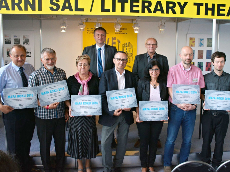
Slavnostní vyhlášení jubilejního 20. ročníku soutěže Mapa roku 2017 proběhne ve čtvrtek 10. května 2018 od 13 hodin v Literárním sále Průmyslového paláce na Výstavišti Praha v rámci veletrhu Svět knihy 2018. Soutěž každoročně pořádá Česká kartografická společnost. Odborná komise již letos zhodnotila přihlášená kartografická díla vydaná na území České republiky za uplynulý rok a určila nominace […]
The post Pozvánka na vyhlášení výsledků soutěže Mapa roku 2017 appeared first on GISportal.cz.
Kóduj pro Česko
9.5.2018 7:00 Česká asociace pro geoinformaceFond Otakara Motejla pořádá ve dnech 25. - 27. května 2018 (Attacama software, Praha - Invalidovna) pátý ročník opendatového hackathonu Kóduj pro Česko. Cílem akce je vývoj a úprava nástrojů a scriptů, které mají konkrétním městům a obcím pomoci s přípravou dat na jejich otevření a publikaci, případně s využíváním otevřených technologií obecně.
Vítáni
Collaborative BIM Approach Delivers Lifecycle Data
9.5.2018 2:00 Bentley SystemsPress Coverage
Civil + Structural Engineer, USA
Read the articlePrůzkumná území
9.5.2018 2:00 Cenia - Katalog metadat ČR - INSPIRE ArcGIS Server služba zpřístupňuje údaje z povolení k provádění geologických prací pro vyhledávání a průzkum ložisek vyhrazených nerostů.Vrtná prozkoumanost
9.5.2018 2:00 Cenia - Katalog metadat ČR - INSPIRE ArcGIS Server služba zpřístupňuje základní informace o vrtech a dalších dílech evidovaných v databázi geologicky dokumentovaných objektů.Lokalizace opatření krajinotvorných programů
9.5.2018 2:00 Cenia - Katalog metadat ČR - INSPIRE Prostorová informace ke smlouvě uzavřené na realizaci opatření krajinotvorného programu; vrstva obsahuje jednoduché prvky (Singlepart Features); AOPK ČR, 2018eWater
9.5.2018 2:00 Cenia - Katalog metadat ČR - INSPIRE ArcGIS Server služba zpřístupňuje základní (signální) informace o hydrogeologických objektech z vrtné databáze.Smart cities: build them up or build them out?
9.5.2018 2:00 Bentley SystemsPress Coverage
TechInvest, ANZ
Read the articleIntegrated Linear Asset Management
9.5.2018 2:00 Bentley SystemsPress Coverage
Civil + Structural Engineer, USA
Read the articlePůdní mapa 1 : 50 000
9.5.2018 2:00 Cenia - Katalog metadat ČR - INSPIRE ArcGIS Server služba zpřístupňuje půdní mapy v měřítku 1 : 50 000 z nové digitální edice ČGS od roku 2012.Půdní mapa 1 : 1 000 000
9.5.2018 2:00 Cenia - Katalog metadat ČR - INSPIRE ArcGIS Server služba zpřístupňuje půdní mapu v měřítku 1:1 000 000, která byla sestavena Milanem Tomáškem a vydána v rámci publikace Půdy České republiky (3.vydání, Česká geologická služba, 2003). Součástí mapové služby je vrstva půdní zrnitosti.Chráněná území pro zvláštní zásahy do zemské kůry
9.5.2018 2:00 Cenia - Katalog metadat ČR - INSPIRE ArcGIS Server služba zobrazuje údaje o chráněných lokalitách zvláštních zásahů do zemské kůry, tedy (§34 zákona 44/1988 Sb.) podzemní zásobníky plynů nebo kapalin, místa ukládání radioaktivních a jiných odpadů v podzemí či objekty průmyslového využívání tepelné energie Země.Microdrones launches three exciting, new product demonstration videos for its professional drone mapping packages
8.5.2018 20:50 GISCafe.com Webcasts-Webinars Rome, NY, May 08, 2018 (GLOBE NEWSWIRE) -- Microdrones has made it easy to learn all about the benefits and solutions provided by the mdMapper1000, …Trimble Adds Crop Health Imagery and Works Orders to its Agriculture Software
8.5.2018 16:28 GISCafe.com Webcasts-Webinars Two New Features Drive Farm ProductivitySUNNYVALE, Calif., May 8, 2018 — (PRNewswire) — Trimble (NASDAQ: TRMB) announced today that it …
CoreLogic Reports Declining Foreclosure Rates in February, Signaling a Strong Economy
8.5.2018 16:28 GISCafe.com Webcasts-Webinars Despite 2017 Hurricanes, National Mortgage Delinquency Rate FellYear Over Year
February Foreclosure Rate Declined 0.2 …
Esri Announces Online Data Portal for Africa
8.5.2018 16:28 GISCafe.com Webcasts-Webinars One-Stop Shop Provides Location Data and Smart Mapping for aSustainable, Progressive Africa
REDLANDS, Calif. — (BUSINESS WIRE) …
Interview with Richard Schgallis, VP Technical Strategy and Solutions, Airbus at GeoINT 2018
8.5.2018 9:00 GISCafe.com Webcasts-WebinarsGeoINT Keynote: The Honorable Sue Gordon, Principal Deputy Director of National Intelligence
8.5.2018 9:00 GISCafe.com Webcasts-WebinarsMapujeme drony v Mongolsku největší asijský důl na měděnou rudu v náročném terénu
8.5.2018 8:53 UpVision Aktuálně mapujeme bezpilotním letadlem v Mongolsku největší asijský důl na měděnou rudu v náročném terénu a proměnlivém počasí (sníh/vítr/vysoké teploty) a děláme podporu českým geologům.Fotky zde:
https://www.facebook.com/permalink.php?story_fbid=737431839778719&id=199025016952740
Carlson PhotoCapture to be presented at GEO Business 2018
7.5.2018 21:18 Carlson Software MAYSVILLE, Kentucky, U.S.A. (May 2018) — Carlson Software will be debuting its photogrammetry solution, Carlson PhotoCapture, during GEO Business 2018, which is being held in London, United Kingdom, May 22-23. The workshop presentation will be held in Room F on Tuesday, May 22, at 1:15 p.m. GMT+1. GEO Business is the initial show for Carlson […]DJI And Microsoft Partner To Bring Advanced Drone Technology To The Enterprise
7.5.2018 20:06 GISCafe.com Webcasts-Webinars REDMOND, Wash., May 7, 2018 — (PRNewswire) — DJI, the world's leader in civilian drones and aerial imaging technology, and Microsoft …OGC seeks public comment on new Interoperable Simulation and Gaming Domain Working Group
7.5.2018 20:03 GISCafe.com Webcasts-Webinars New OGC Working Group has the goal of evaluating how standards will enable the modeling, simulation, and gaming communities to mutually …
Acting FAA Administrator Daniel K. Elwell to Deliver Grand Opening Keynote Address at InterDrone 2018
7.5.2018 20:03 GISCafe.com Webcasts-Webinars Marking the Third Federal Aviation Administration Grand Keynote at the Show
NEW YORK – May 7, 2018 — Emerald Expositions …
National Geospatial-Intelligence Agency Awards Leidos $250 Million Task Orders
7.5.2018 16:27 GISCafe.com Webcasts-Webinars RESTON, Va., May 7, 2018 — (PRNewswire) — Leidos (NYSE: LDOS), a FORTUNE 500® science, information technology, and engineering leader, …Zveřejnění návrhu Metropolitního plánu Prahy
7.5.2018 14:05 ARCDATAMetropolitní plán Prahy komplexním způsobem vyjadřuje vizi rozvoje města v příštích desetiletích. Zpracovává koncepci celého města, včetně rozvoje infrastruktury nebo ploch pro novou bytovou výstavbu. Řídit se jím bude veřejná správa, investoři i občané. Odbor územního rozvoje Magistrátu hl. m. Prahy zveřejnil návrh Metropolitního plánu, jehož jednotlivé části (texty i výkresy) lze prohlížet v aplikaci Institutu plánování a rozvoje hl. m. Prahy.
Jednotlivé vrstvy a výkresy lze také nalézt na ArcGIS Online a přímo si je tak připojit do ArcGIS Desktop nebo do své webové aplikace.

Zveřejnění Metropolitního plánu Prahy
7.5.2018 14:05 ARCDATAMetropolitní plán Prahy komplexním způsobem vyjadřuje vizi rozvoje města v příštích desetiletích. Zpracovává koncepci celého města, včetně rozvoje infrastruktury nebo ploch pro novou bytovou výstavbu. Řídit se jím bude veřejná správa, investoři i občané. Odbor územního rozvoje Magistrátu hl. m. Prahy zveřejnil návrh Metropolitního plánu, jehož jednotlivé části (texty i výkresy) lze prohlížet v aplikaci Institutu plánování a rozvoje hl. m. Prahy.
Jednotlivé vrstvy a výkresy lze také nalézt na ArcGIS Online a přímo si je tak připojit do ArcGIS Desktop nebo do své webové aplikace.
Zveřejnění návrhu Metropolitního plánu Prahy
7.5.2018 14:05 ARCDATAMetropolitní plán Prahy komplexním způsobem vyjadřuje vizi rozvoje města v příštích desetiletích. Zpracovává koncepci celého města, včetně rozvoje infrastruktury nebo ploch pro novou bytovou výstavbu. Řídit se jím bude veřejná správa, investoři i občané. Odbor územního rozvoje Magistrátu hl. m. Prahy zveřejnil návrh Metropolitního plánu, jehož jednotlivé části (texty i výkresy) lze prohlížet v aplikaci Institutu plánování a rozvoje hl. m. Prahy.
GPS and Galileo working together will make the world more precise
7.5.2018 9:58 European GNSS Agency.")
Keynote address at the 34th Space Symposium, the premier space event in the world, reviewed the achievements of the European Union’s (EU) flagship space programmes– Galileo, EGNOS and Copernicus – and outlined the three paradigms driving future EU space policies.
European Commission Head of Cabinet Tomasz Husak outlined the achievements of the European Union’s (EU) flagship space programmes while emphasising the three major paradigm shifts driving future European space policies during his keynote address at the 34th Space Symposium April 17, 2018, in Colorado Springs, Colorado. U.S.A.
The four-day conference is the premier international event for the space sector, and annually attracts thousands of participants, hundreds of exhibits and big-name speakers.
“Our three operational programmes, Galileo, EGNOS and Copernicus are on track and on budget,” reported Husak. “Over the past three years, with Copernicus, the EU has become one of the biggest data providers in the world. The quality of Copernicus Sentinels data and products are setting a global standard in Earth observation. Our services are offering the most accurate climate and environmental data 24/7.”

The EU Space Programmes stand team present Galileo, EGNSOS and Copernicus at the 34th Space Symposium
He also noted that a little over one year after the declaration of “initial services,” Galileo, the European satellite navigation infrastructure, is experiencing significant market adoption.
“We estimate that some 75 million Galileo-enabled smartphones have been sold globally,” said Husak. “The benefits of Galileo will only increase as we are moving toward completion of the constellation and full operational capabilities.”
Galileo currently consists of 22 spacecraft with four more satellites launching this year. Major manufacturers, such as Apple, Google, Samsung and Sony now offer Galileo-enabled products. And due to the combined signals between the United States’ Global Positioning System (GPS) and Galileo, global users will enjoy much better geo-positioning.
“Thanks to the GPS and Galileo working together, the world can expect more precise navigation,” explained Husak. “The use of data provided by these two systems will deliver improved emergency services, safer aviation and numerous other applications that will drive new business innovation, such as automated cars and the Internet of Things.”
Husak added that while Europe’s civilian-led satellite technology programmes were designed to achieve autonomy and depart in mission somewhat from the dual military/civil GPS programme of the United States, it doesn’t mean that the EU excludes collaboration with others – far from it.
No one is powerful enough to boldly go alone
His remarks reinforced the position set forth by EU Commissioner Elżbieta Bieńkowska in a recent commentary piece featured in the Space Symposium issue of Space News.
“In space, no one is powerful enough to boldly go alone,” proclaimed Bieńkowska. “Space matters in Europe and it is a top political priority. But the European Union’s efforts to achieve autonomy in space don’t mean we act in isolation. Europe wants to make itself an attractive place for public and private investors, including Americans, who want to invest in space startups and other businesses. Venture capital investment will be incentivised in Europe. As free marketers, we obviously trust that innovation and free competition will [drive] new ideas [on] how to use combined GPS and Galileo [to] drive business on both sides of the Atlantic. ”
Beyond free enterprise, Bieńkowska cited space research and exploration as two other great societal benefits of space collaboration.
“On space exploration and satellite navigation the European Space Agency [ESA] cooperates with NASA on the International Space Station, telescopes and robotic space missions,” she wrote. “ESA provides the service modules for the future Orion capsule and will launch the James Webb Space Telescope. And a Belgian Michael Gillon, funded by EU money, led the international team that discovered the planetary system TRAPPIST-1 in February 2018. The discovery came from cooperation between Americans and Europeans.”
No resting on laurels. Looking ahead to future EU space policies
Noting that Europe will not rest on its laurels, Husak in his Symposium address went on to underscore the three major changes occurring within the space sector that will influence the future of EU space policies.
“First, space has become truly important for our economy and society, so we will continue to put users at the centre of our space programmes,” he said. “Second, space is the enabler of security and defence, two top concerns among our citizens. Third, the role of the private sector is changing as an initiator of space projects. Public programmes need to work hand-in-hand with these new dynamics.”
Media note: This feature can be republished without charge provided the European GNSS Agency (GSA) is acknowledged as the source at the top or the bottom of the story. You must request permission before you use any of the photographs on the site. If you republish, we would be grateful if you could link back to the GSA website (http://www.gsa.europa.eu).
ESA a NASA řeší, kterak dostat horninu z Marsu na Zemi
7.5.2018 9:04 Český Kosmický PortálESA a NASA podepsaly dohodu o společném zájmu studovat možnosti mise, která by přivezla vzorky horninu z Marsu na Zemi.
GeoINT Keynote: Scott Hartley-Venture Capitalist & Author,The Fuzzy and the Techie: Why the Liberal Arts Will Rule the Digital World
7.5.2018 9:00 GISCafe.com Webcasts-WebinarsInterview with Daryl Madden, Senior Vice President, Textron Systems at 2018 GeoINT
7.5.2018 9:00 GISCafe.com Webcasts-WebinarsFotili jsme dronem jarní rozkvetlé sady na kraji Českého ráje
7.5.2018 8:53 UpVision Fotili jsme dronem jarní rozkvetlé sady na okraji Českého ráje.Zde je několik fotografií:
https://www.facebook.com/permalink.php?story_fbid=733520496836520&id=199025016952740
"Calling All Geospatial Data Providers for Upcoming GISCafe Special Coverage" by Susan Smith
6.5.2018 10:40 GISCafe.com Webcasts-WebinarsStomegapixelový středoformát Phase One iMX 100MP pro letecké snímkování
5.5.2018 7:02 GeoBusiness Společnost Phase One představila nový středoformátový fotoaparát iMX 100MP, který je určen například pro letecké snímkování z dronů. Fotoaparát má velký středoformátový CMOS BSI ... PřečístRFP: Long Range/Ultra-Long Endurance UAS Technology Demonstration
4.5.2018 19:17 GISCafe.com Webcasts-Webinars May 4, 2018 -- The United States Coast Guard Research and Development Center (RDC) has a requirement for a technology demonstration of Long Range, …ESA and Vatican work to preserve heritage data
4.5.2018 18:00 ESA Observing the Earth
Following an agreement signed in 2016, ESA and the Vatican Apostolic Library have presented the preliminary results on how they are using the same method to manage their respective long-term data preservation projects and how this can create new initiatives.
Sonda mise ExoMars odeslala první snímky z nové oběžné dráhy
4.5.2018 17:03 Český Kosmický PortálSonda TGO (Trace Gas Orbiter) mise ExoMars dodala z nově dosažené oběžné dráhy první snímky planety Mars.
Hexagon Interim Report 1 January - 31 March 2018
4.5.2018 16:20 GISCafe.com Webcasts-Webinars NACKA STRAND, Sweden, May 4, 2018 — (PRNewswire) — First Quarter 2018Net sales increased by 7 per cent to 834.7 MEUR (779.2). …
Odborný referent – zápisy v řízení V a Z v oddělení právních vztahů k nemovitostem Katastrálního pra
4.5.2018 14:32 ČÚZK /Urady/Katastralni-urady/Katastralni-urady/Katastralni-urad-pro-Zlinsky-kraj/Uredni-deska/Oznameni-a-jina-uredni-sdeleni/Volna-mista/Odborny-referent-–-zapisy-v-rizeni-V-a-Z-v-oddelenOdborný referent – zápisy v řízení V a Z v oddělení právních vztahů k nemovitostem Katastrálního pra
4.5.2018 14:32 ČÚZK - předpisy a opatření Katastrální úřad pro Zlínský kraj - Katastrální pracoviště Uherské Hradištěvypisuje výběrové řízení na místo
Odborný referent – zápisy v řízení V a Z v oddělení právních vztahů k nemovitostem Katastrálního pracoviště Uherské Hradiště
Odborný referent – zápisy v řízení V a Z v oddělení právních vztahů k nemovitostem Katastrálního pra
4.5.2018 14:32 ČÚZK - volná místa Katastrální úřad pro Zlínský kraj - Katastrální pracoviště Uherské Hradiště vypisuje výběrové řízení na místo Odborný referent – zápisy v řízení V a Z v oddělení právních vztahů k nemovitostem Katastrálního praOGC announced as official partner of Earth Challenge 2020, a Citizen Science Initiative
4.5.2018 11:09 GISCafe.com Webcasts-Webinars Largest ever coordinated citizen science data collection campaign will collect one billion data points on air and water quality, pollution, human …odborný referent/vrchní referent – správce informačních
4.5.2018 10:59 ČÚZK /Urady/Katastralni-urady/Katastralni-urady/Katastralni-urad-pro-Vysocinu/O-uradu/Aktuality/odborny-referent-vrchni-referent-–-spravce-informaodborný referent/vrchní referent – správce informačních
4.5.2018 10:59 ČÚZK - předpisy a opatření Katastrální úřad pro Vysočinu zveřejnil novou aktualitu: Oznámení o vyhlášení výběrového řízení na služební místo odborný referent/vrchní referent – správce informačních a komunikačních technologií v oddělení podpory ICT. Oznámení o vyhlášení výběrového řízení na služební místo odborný referent/vrchní referent – správce informačních a komunikačních technologií v oddělení podpory ICT Technického odboru na Katastrálním úřadu pro Vysočinu, místo výkonu služby Jihlava, více zde.odborný referent/vrchní referent – správce informačních a komunikačních technologií v oddělení podpo
4.5.2018 10:56 ČÚZK - předpisy a opatření Katastrální úřad pro Vysočinuvypisuje výběrové řízení na místo odborný referent/vrchní referent – správce informačních a komunikačních technologií v oddělení podpory ICT Technického odboru na Katastrálním úřadu pro Vysočinu.
odborný referent/vrchní referent – správce informačních a komunikačních technologií v oddělení podpory ICT Technického odboru na Katastrálním úřadu pro Vysočinu.
odborný referent/vrchní referent – správce informačních a komunikačních technologií v oddělení podpo
4.5.2018 10:56 ČÚZK - volná místa Katastrální úřad pro Vysočinu vypisuje výběrové řízení na místo odborný referent/vrchní referent – správce informačních a komunikačních technologií v oddělení podpoodborný referent/vrchní referent – správce informačních a komunikačních technologií v oddělení podpo
4.5.2018 10:56 ČÚZK /Urady/Katastralni-urady/Katastralni-urady/Katastralni-urad-pro-Vysocinu/Uredni-deska/Oznameni-a-jina-uredni-sdeleni/Volna-mista/odborny-referent-vrchni-referent-–-spravce-informaodborný referent – zápisy v řízení V a Z
4.5.2018 10:21 ČÚZK - volná místa Katastrální úřad pro Olomoucký kraj - Katastrální pracoviště Olomouc vypisuje výběrové řízení na místo odborný referent – zápisy v řízení V a Zodborný referent – zápisy v řízení V a Z
4.5.2018 10:21 ČÚZK - předpisy a opatření Katastrální úřad pro Olomoucký kraj - Katastrální pracoviště Olomoucvypisuje výběrové řízení na místo
odborný referent – zápisy v řízení V a Z
odborný referent – zápisy v řízení V a Z
4.5.2018 10:21 ČÚZK /Urady/Katastralni-urady/Katastralni-urady/Katastralni-urad-pro-Olomoucky-kraj/Uredni-deska/Oznameni-a-jina-uredni-sdeleni/Volna-mista/odborny-referent-–-zapisy-v-rizeni-V-a-Zodborný referent – poskytování informací KN a PK, poskytování podkladů, nahlížení do KN
4.5.2018 10:08 ČÚZK /Urady/Katastralni-urady/Katastralni-urady/Katastralni-urad-pro-Olomoucky-kraj/Uredni-deska/Oznameni-a-jina-uredni-sdeleni/Volna-mista/odborny-referent-–-poskytovani-informaci-KN-a-(1)odborný referent – poskytování informací KN a PK, poskytování podkladů, nahlížení do KN
4.5.2018 10:08 ČÚZK - volná místa Katastrální úřad pro Olomoucký kraj - Katastrální pracoviště Olomouc vypisuje výběrové řízení na místo odborný referent – poskytování informací KN a PK, poskytování podkladů, nahlížení do KNodborný referent – poskytování informací KN a PK, poskytování podkladů, nahlížení do KN
4.5.2018 10:08 ČÚZK - předpisy a opatření Katastrální úřad pro Olomoucký kraj - Katastrální pracoviště Olomoucvypisuje výběrové řízení na místo
odborný referent – poskytování informací KN a PK, poskytování podkladů, nahlížení do KN
Earth from space
4.5.2018 10:05 ESA Observing the Earth
In this week's edition, explore the Emi Koussi volcano in northern Chad with Sentinel-2B
Emi Koussi
4.5.2018 10:05 ESA Observing the Earth
Earth observation image of the week: Sentinel-2B takes us over the Emi Koussi volcano in northern Chad
Precise and robust positioning for automated road transportation
4.5.2018 9:54 European GNSS Agency
The Horizon 2020 funded PRoPART project is developing an enhanced Real Time Kinematic (RTK) software solution for automated vehicles and advanced driver assistance systems. To do this, project researchers are combining some of Galileo’s distinguishing features with other positioning and sensor technologies.
‘Vision Zero’ is a point in the future that is free of deadly and catastrophic motor vehicle accidents. Thanks to the development of automated vehicles and other advanced driver assistance systems, which are predicted to reduce traffic density and increase travel efficiency, this vision is quickly becoming a reality.
However, before we can reach Vision Zero, we first need to develop the precise and robust positioning technology that these automated vehicles and advanced driver assistance systems demand – which is exactly what the GSA-funded Horizon 2020 PRoPART project has set out to do.
Today’s autonomous vehicles use a variety of sensors, starting from GNSS but also including cameras, laser scanners, ultrasonic and radar. The connected and automated vehicle applications currently being developed depend on these systems being able to cooperate in order to determine the vehicle’s absolute position relative to any obstacles.
“No single technology is capable of providing the required absolute positioning in all situations, and when we combine different technologies, it becomes vital that we understand the integrity of the available information,” explains Project Coordinator Stefan Nord. “The PRoPART project aims to develop and enhance an existing GNSS RTK (Real Time Kinematic) software solution by exploiting the distinguished features of Galileo signals, as well as combining it with other positioning and sensor technologies.”
The GNSS benefit
To provide this required integrity, PRoPART proposes an RTK technique that is already widely used for precise GNSS positioning based on the use of code and carrier phase measurements coming from the main GNSS constellations (i.e., GPS, Galileo). Although the use of carrier phase measurements allows for centimetre level accuracies, it also means one must confirm the integrity of such signals – which is a complex and time-consuming process.
“One limitation with the RTK technique is that it requires reference data from a location relatively close to the user in order to mitigate against signal errors caused by, for example, satellite position error,” explains Nord. “Similar to all satellite positioning technologies there can also be areas with poor coverage or signal interference, such as in tunnels or urban canyons.”
Luckily, Galileo ensures higher multipath mitigation and a substantial improvement on the reliability of the carrier phase’s ambiguity resolution. “By including Galileo, the PRoPART project will provide users with a deeply integrated, multi-constellation, multi-channel navigation system that fulfils the requirements on availability and precision for an automated driving function,” adds Nord. The PRoPART project will also augment road infrastructure to provide the reference data required for high accuracy positioning.
Transition period
Nord notes that because there will be a transition period where a lot of vehicles are neither connected nor fully automated, there is a market need for solutions offering high impact during low penetration. PRoPART meets this market need by implementing a Road Side Unit, or RSU, with high precision positioning and that uses both UWB and a traffic monitoring sensor to supply ranging, object perception and EGNSS RTK correction data to the connected automated vehicle. “This allows the vehicle to make safe decisions based on robust data,” he says.
PRoPART will demonstrate its positioning solution using a truck capable of automated driving on motorway conditions.
The project is a consortium of seven partners: RISE, AstaZero, Scania, Waysure, Fraunhofer IIS, Ceit-IK4, Baselabs and Commsignia.
Media note: This feature can be republished without charge provided the European GNSS Agency (GSA) is acknowledged as the source at the top or the bottom of the story. You must request permission before you use any of the photographs on the site. If you republish, we would be grateful if you could link back to the GSA website (http://www.gsa.europa.eu).
OGC se stává oficiálním partnerem iniciativy Earth Challenge 2020
4.5.2018 9:48 GISportal.cz
V rámci 50. Dne země, který připadá na 22. dubna 2020, byla vyvinuta iniciativa Earth Challenge 2020. Jejím cílem je posbírat celkem jednu miliardu bodů s informacemi o znečištění vzduchu a vody či stavu životního prostředí. Do sběru dat by se za asistence vědců měly zapojit miliony uživatelů, kteří budou školení na hackathonech. Ty se […]
The post OGC se stává oficiálním partnerem iniciativy Earth Challenge 2020 appeared first on GISportal.cz.
Maxar Technologies to Present at RBC Capital Markets Canadian Automotive, Industrials & Transportation Conference on May 15
4.5.2018 9:00 GISCafe.com Webcasts-Webinars WESTMINSTER, Colo. — (BUSINESS WIRE) — May 2, 2018 — Maxar Technologies (formerly MacDonald, Dettwiler and Associates Ltd.) (NYSE: …Interview with Richard Blain, CEO from Earth-i at GeoINT 2018
4.5.2018 9:00 GISCafe.com Webcasts-WebinarsAUTO terénní UAZ Patriot
4.5.2018 8:52 ČÚZK /Urady/Zememericky-urad/Nabidka-majetku/AUTO-terenni-UAZ-PatriotAUTO terénní UAZ Patriot
4.5.2018 8:52 ČÚZK - předpisy a opatřeníZeměměřický úřad nabízí nepotřebný majetek k odkupu. Jedná se o
AUTO terénní UAZ Patriot
AUTO terénní UAZ Patriot
4.5.2018 8:52 Zeměměřický úřadZeměměřický úřad nabízí nepotřebný majetek k odkupu. Jedná se o
AUTO terénní UAZ Patriot
Odborný referent v oddělení obnovy katastrálního operátu (03020) technického útvaru Katastrálního úř
4.5.2018 8:25 ČÚZK - volná místa Katastrální úřad pro Královéhradecký kraj vypisuje výběrové řízení na místo Odborný referent v oddělení obnovy katastrálního operátu (03020) technického útvaru Katastrálního úřOdborný referent v oddělení obnovy katastrálního operátu (03020) technického útvaru Katastrálního úř
4.5.2018 8:25 ČÚZK /Urady/Katastralni-urady/Katastralni-urady/Katastralni-urad-pro-Kralovehradecky-kraj/Volna-mista/Odborny-referent-v-oddeleni-obnovy-katastralni-(2)Odborný referent v oddělení obnovy katastrálního operátu (03020) technického útvaru Katastrálního úř
4.5.2018 8:25 ČÚZK - předpisy a opatření Katastrální úřad pro Královéhradecký krajvypisuje výběrové řízení na místo
Odborný referent v oddělení obnovy katastrálního operátu (03020) technického útvaru Katastrálního úřadu pro Královéhradecký kraj
uzavření KP
4.5.2018 8:24 ČÚZK - předpisy a opatření Katastrální úřad pro Vysočinu - Katastrální pracoviště Jihlava zveřejnil novou aktualitu: V pátek dne 18.5.2018 bude z technických důvodů spojených s výměnou komponentů počítačové sítě uzavřeno pro veřejnost Katastrální pracoviště Jihlava. V pátek dne 18.5.2018 bude z technických důvodů spojených s výměnou komponentů počítačové sítě uzavřeno pro veřejnost Katastrální pracoviště Jihlava Katastrálního úřadu pro Vysočinu, více zde.uzavření KP
4.5.2018 8:24 ČÚZK /Urady/Katastralni-urady/Katastralni-urady/Katastralni-urad-pro-Vysocinu/Katastralni-pracoviste/KP-Jihlava/O-uradu/Aktuality/uzavreni-KPVrchní referent/rada – správce informačních a komunikačních technologií v oddělení podpory ICT techn
4.5.2018 8:17 ČÚZK /Urady/Katastralni-urady/Katastralni-urady/Katastralni-urad-pro-Kralovehradecky-kraj/Uredni-deska/Oznameni-a-jina-uredni-sdeleni/Volna-mista/Vrchni-referent-rada-–-spravce-informacnich-a-(1)Vrchní referent/rada – správce informačních a komunikačních technologií v oddělení podpory ICT techn
4.5.2018 8:17 ČÚZK - předpisy a opatření Katastrální úřad pro Královéhradecký krajvypisuje výběrové řízení na místo
Vrchní referent/rada – správce informačních a komunikačních technologií v oddělení podpory ICT technického útvaru Katastrálního úřadu pro Královéhradecký kraj