


![]()

zprávy
zdroje zpráv:
Víťaz ceny ITAPA 2017
21.11.2017 7:00
ÚGKK SR
Absolútnym víťazom 16. ročníka súťaže o najlepší projekt digitalizácie spoločnosti - Ceny ITAPA 2017 sa stal spomedzi 25 prihlásených projektov projekt Úradu geodézie, kartografie a katastra s názvom Mapový klient ZBGIS.
Mapový klient ZBGIS získal aj Cenu Rádia Slovensko, ktorú udeľujú priamo poslucháči RTVS.
Odborný rada – metodik v oddělení metodiky a kontroly v kanceláři ředitele Katastrálního úřadu pro K
21.11.2017 6:57 ČÚZK - volná místa Katastrální úřad pro Královéhradecký kraj vypisuje výběrové řízení na místo Odborný rada – metodik v oddělení metodiky a kontroly v kanceláři ředitele Katastrálního úřadu pro KOdborný rada – metodik v oddělení metodiky a kontroly v kanceláři ředitele Katastrálního úřadu pro K
21.11.2017 6:57 ČÚZK - předpisy a opatření Katastrální úřad pro Královéhradecký krajvypisuje výběrové řízení na místo
Odborný rada – metodik v oddělení metodiky a kontroly v kanceláři ředitele Katastrálního úřadu pro Královéhradecký kraj
Odborný rada – metodik v oddělení metodiky a kontroly v kanceláři ředitele Katastrálního úřadu pro K
21.11.2017 6:57 ČÚZK /Urady/Katastralni-urady/Katastralni-urady/Katastralni-urad-pro-Kralovehradecky-kraj/Uredni-deska/Oznameni-a-jina-uredni-sdeleni/Volna-mista/Odborny-rada-–-metodik-v-oddeleni-metodiky-a-kontrJaká byla konference GIS Esri v ČR
21.11.2017 6:27 GISportal.cz Již tradičně se v listopadu koná konference GIS Esri v ČR, kdy letošní ročník a jeho hlavní program proběhl minulou středu a čtvrtek (8. až 9. listopadu 2017) opět v Kongresovém Centru Praha. Téměř tisícovka ...Geotech Joins Forces with Microdrones® to Bring Drones to Surveyors and Construction Pros in Greece
21.11.2017 1:20 GISCafe.com Webcasts-Webinars Athens, Greece, Nov. 20, 2017 (GLOBE NEWSWIRE) -- Microdrones is pleased to announce that Geotech, a leading geospatial equipment provider in …WMS INSPIRE Habitats and Biotopes
21.11.2017 1:00 Cenia - Katalog metadat ČR - INSPIRE The map service displays the grid distribution of natural habitat types of community interest (EEA reference grid 1 x 1 km) on the territory of the Czechia. The natural habitat types are grouped. The distribution had been compiled from data of habitat reports 2013. © NCA CR (AOPK ČR), 2013INSPIRE Natural habitat types of community interest distribution
21.11.2017 1:00 Cenia - Katalog metadat ČR - INSPIRE Distribution of natural habitat types of community interest is a product of species and biotopes surveillance under the obligations of Article 17 of EU Habitats Directive (92/43/ EEC). The grid distribution (EEA reference grid 1 x 1 km) from data of habitat reports 2013 is presented. For detailed description and commentary see CHOBOT K. (2016). Druhy a přírodní stanoviště. Hodnotící zprávy o stavu v České republice 2013. Agentura ochrany přírody a krajiny ČR & Ministerstvo životního prostředí, Praha. 226 str., ISBN 978-80-8076-20-9. Habitat classification and national interpretation manual see CHYTRÝ, M.; KUČERA, T.; KOČÍ, M. (eds.) et al. (2010). Katalog biotopů České republiky. 2.upr. a rozš. vyd. Praha: Agentura ochrany přírody a krajiny ČR. 445 s. ISBN 978-80-87457-03-0. © NCA CR (AOPK ČR), 2013Oznámení o vyhlášení výběrového řízení na služební místo vrchní referent/rada, Pobočka Nymburk
21.11.2017 0:00 Státní pozemkový úřad Ústřední ředitelka Státního pozemkového úřadu, jako služební orgán příslušný podle § 10 odst. 1 písm. f) zákona č. 234/2014 Sb., o státní službě (dále jen „zákon“), vyhlašuje výběrové řízení na služební místo vrchní referent/rada, Pobočka Nymburk.Oznámení o vyhlášení výběrového řízení na služební místo odborný rada oddělení řízení lidských zdrojů, odbor personální
21.11.2017 0:00 Státní pozemkový úřad Ústřední ředitelka Státního pozemkového úřadu, jako služební orgán příslušný podle § 10 odst. 1 písm. f) zákona č. 234/2014 Sb., o státní službě (dále jen „zákon“), vyhlašuje výběrové řízení na služební místo odborný rada oddělení řízení lidských zdrojů, odbor personální.Oznámení o vyhlášení výběrového řízení na služební místo vedoucí oddělení správy majetku státu, Krajský pozemkový úřad pro Středočeský kraj a hl. m. Prahu
21.11.2017 0:00 Státní pozemkový úřad Ústřední ředitelka Státního pozemkového úřadu, jako služební orgán příslušný podle § 10 odst. 1 písm. f) zákona č. 234/2014 Sb., o státní službě (dále jen „zákon“), vyhlašuje výběrové řízení na služební místo vedoucí oddělení správy majetku státu, Krajský pozemkový úřad pro Středočeský kraj a hl. m. Prahu.OnTerra Systems Introduces New Version of MapSavvy Web Map Service
20.11.2017 20:56 GISCafe.com Webcasts-Webinars DENVER, Nov. 20, 2017 (GLOBE NEWSWIRE) -- OnTerra Systems today introduced a new version of its MapSavvy aerial imagery service and a corresponding …SpaceKnow hires Jeremy Fand as VP of Product Development
20.11.2017 20:54 GISCafe.com Webcasts-Webinars SAN FRANCISCO, Nov. 20, 2017 — (PRNewswire) — SpaceKnow, a leading provider of geospatial analytics, is pleased to announce the …Novela stavebního zákona 225/2017 Sb.
20.11.2017 20:20 Asociace poskytovatelů služeb v pozemkových úpravách Novela č. 225/2017 Sb., která kromě stavebního zákona mění také dalších 44 souvisejících zákonů včetně zákona o ochraně ZPF (č. 334/1192 Sb.), lesního zákona (č. 289/1995 Sb.), zákona o pozemkových úpravách a pozemkových úřadech (č. 139/2002 Sb.) nebo zákona o Státním pozemkovém úřadu (č. 503/2012 Sb.), nabude účinnosti prvním dnem šestého kalendářního měsíce následujícího po jejím vyhlášení, tedy 1. ledna 2018. Text…NASA Launches NOAA Weather Satellite Aboard United Launch Alliance Rocket to Improve Forecasts
20.11.2017 17:45 GISCafe.com Webcasts-Webinars WASHINGTON, Nov. 18, 2017 — (PRNewswire) — NASA has successfully launched for the National Oceanic and Atmospheric Administration …Informace o chystaných akcích
20.11.2017 16:41 GISportal.cz O dvou chystaných akcích informoval nedávno web ČAGI. 16. května 2018 se u příležitosti výročí vydání Klaudyánovy mapy bude konat slavnostní zasedání s konferencí pod názvem Mikuláš Klaudyán 1518/2018, 500 let od vydání první tištěné ...O dvou chystaných akcích infor
20.11.2017 16:38 GISportal.cz O dvou chystaných akcích informoval nedávno web ČAGI. 16. května 2018 se u příležitosti výročí vydání Klaudyánovy mapy bude konat slavnostní zasedání s konferencí pod názvem Mikuláš Klaudyán 1518/2018, 500 let od vydání první tištěné ...Vzhůru na Měsíc
20.11.2017 16:23 Česká kosmická kancelář
Česká kosmická kancelář navázala spolupráci s americkou společností Astrobotic Technology, která našim pracovištím nabízí dopravu malého vědeckého zařízení na povrch Měsíce. Bližší informace o technických i finančních aspektech budou poskytnuty na připravovaném workshopu, který se uskuteční 23. listopadu 2017 v kanceláři CSO.
Vzhůru na Měsíc
20.11.2017 16:23 Česká kosmická kancelář
Česká kosmická kancelář navázala spolupráci s americkou společností Astrobotic Technology, která našim pracovištím nabízí dopravu malého vědeckého zařízení na povrch Měsíce. Bližší informace o technických i finančních aspektech budou poskytnuty na připravovaném workshopu, který se uskuteční 23. listopadu 2017 v kanceláři CSO.
vedoucí oddělení obnovy katastrálního operátu (3010) Katastrálního úřadu pro Pardubický kraj
20.11.2017 13:55 ČÚZK - předpisy a opatření Katastrální úřad pro Pardubický krajvypisuje výběrové řízení na místo
vedoucí oddělení obnovy katastrálního operátu (3010) Katastrálního úřadu pro Pardubický kraj
vedoucí oddělení obnovy katastrálního operátu (3010) Katastrálního úřadu pro Pardubický kraj
20.11.2017 13:55 ČÚZK - volná místa Katastrální úřad pro Pardubický kraj vypisuje výběrové řízení na místo vedoucí oddělení obnovy katastrálního operátu (3010) Katastrálního úřadu pro Pardubický krajV mapové aplikaci byla aktual
20.11.2017 12:00 Jihočeský kraj V mapové aplikaci byla aktualizována územně plánovací dokumentace obcí Doubravice, Horní Pěna, Vráto a Volyně. Nově pak byla přidána územně plánovací dokumentace obcí Strašice, Střelské Hoštice, Štěchovice, Štěkeň a Třebohostice.V mapové aplikaci Územně pláno
20.11.2017 12:00 Jihočeský kraj V mapové aplikaci Územně plánovací dokumentace obcí byla aktualizována územně plánovací dokumentace obcí Doubravice, Horní Pěna, Vráto a Volyně. Nově pak byla přidána územně plánovací dokumentace obcí Strašice, Střelské Hoštice, Štěchovice, Štěkeň a Třebohostice.20171120 - Odborný referent v oddělení podpory ICT v technickém odboru na KÚ pro Ústecký kraj
20.11.2017 11:21 ČÚZK /Urady/Katastralni-urady/Katastralni-urady/Katastralni-urad-pro-Ustecky-kraj/O-uradu/Aktuality/20171120-Odborny-referent-v-oddeleni-podpory-ICT20171120 - Odborný referent v oddělení podpory ICT v technickém odboru na KÚ pro Ústecký kraj
20.11.2017 11:21 ČÚZK - předpisy a opatření Katastrální úřad pro Ústecký kraj zveřejnil novou aktualitu: Nabídka volného pracovního místa - Odborný referent v oddělení podpory ICT v technickém odboru na Katastrálním úřadu pro Ústecký krajGSA management systems better than ever
20.11.2017 11:20 European GNSS AgencyThe European GNSS Agency (GSA) has successfully qualified its ISO 9001: 2015-compliant management system as part of this year's re-certification audit. The audit revealed that quality management processes at the agency have improved as a result of being adapted and developed since the previous audit.
In this year’s recertification audit, the Lloyds Register (LRQA) auditors paid particular attention to the effectiveness of the GSA quality management system, and found that there were no deviations from the requirements of the standard.
Commenting on the audit results, GSA Executive Director Carlo Des Dorides said that ISO certification, complemented by ECSS (European Cooperation for Space Standardisation) and ITIL best practices for IT service management, was not only important proof of the agency’s services, processes and customer orientation, but also evidence that the GSA is ready to implement operations in a sustainable manner. “In this respect, we are very happy about the confirmation of the certificate, also against the background of GSA now being the Galileo service provider," he said.
Appreciation of new tools and processes
During the re-certification, the GSA performed well and fulfilled all the criteria. As a special strength, it was emphasised that that GSA had been able to further improve its definition of operational processes. The audit also found that the GSA implements risk management at best practice levels and has developed an agency-wide work breakdown structure.
"The successful ISO 9001 re-certification is good news for GSA, as we have worked hard in the past few months to adapt our quality management to the role of being a service operator," said Patrick Hamilton, Head of the Project Control Department. "The fact that the audit has confirmed this so positively confirms our efforts and is also an incentive to continually evaluate and optimise our services and processes."
About ISO 9001
The International Standards Organisation (ISO) is a worldwide federation of national standards bodies (ISO member bodies). The work of preparing International Standards is carried out through ISO technical committees, in liaison with international organisations, governmental and non-governmental bodies.
The ISO 9001 certification is the most widely used and most important standard in quality management at national and international level. It sets standards that ensure transparency of operational procedures and increase customer satisfaction, as well as ensuring optimal operational structures. After a re-certification, the certification is valid for three years, but is checked annually in the context of so-called monitoring audits.
Media note: This feature can be republished without charge provided the European GNSS Agency (GSA) is acknowledged as the source at the top or the bottom of the story. You must request permission before you use any of the photographs on the site. If you republish, we would be grateful if you could link back to the GSA website (http://www.gsa.europa.eu).
GSA management systems better than ever
20.11.2017 11:20 European GNSS Agency
The European GNSS Agency (GSA) has successfully qualified its ISO 9001: 2015-compliant management system as part of this year's re-certification audit. The audit revealed that quality management processes at the agency have improved as a result of being adapted and developed since the previous audit.
In this year’s recertification audit, the Lloyds Register (LRQA) auditors paid particular attention to the effectiveness of the GSA quality management system, and found that there were no deviations from the requirements of the standard.
Commenting on the audit results, GSA Executive Director Carlo Des Dorides said that ISO certification, complemented by ECSS (European Cooperation for Space Standardisation) and ITIL best practices for IT service management, was not only important proof of the agency’s services, processes and customer orientation, but also evidence that the GSA is ready to implement operations in a sustainable manner. “In this respect, we are very happy about the confirmation of the certificate, also against the background of GSA now being the Galileo service provider," he said.
Appreciation of new tools and processes
During the re-certification, the GSA performed well and fulfilled all the criteria. As a special strength, it was emphasised that that GSA had been able to further improve its definition of operational processes. The audit also found that the GSA implements risk management at best practice levels and has developed an agency-wide work breakdown structure.
"The successful ISO 9001 re-certification is good news for GSA, as we have worked hard in the past few months to adapt our quality management to the role of being a service operator," said Patrick Hamilton, Head of the Project Control Department. "The fact that the audit has confirmed this so positively confirms our efforts and is also an incentive to continually evaluate and optimise our services and processes."
About ISO 9001
The International Standards Organisation (ISO) is a worldwide federation of national standards bodies (ISO member bodies). The work of preparing International Standards is carried out through ISO technical committees, in liaison with international organisations, governmental and non-governmental bodies.
The ISO 9001 certification is the most widely used and most important standard in quality management at national and international level. It sets standards that ensure transparency of operational procedures and increase customer satisfaction, as well as ensuring optimal operational structures. After a re-certification, the certification is valid for three years, but is checked annually in the context of so-called monitoring audits.
Media note: This feature can be republished without charge provided the European GNSS Agency (GSA) is acknowledged as the source at the top or the bottom of the story. You must request permission before you use any of the photographs on the site. If you republish, we would be grateful if you could link back to the GSA website (http://www.gsa.europa.eu).
Poruchy a odstávky zveřejňuje Severočeská teplárenská prostřednictvím mapové aplikace
20.11.2017 10:52 GIS Fórum Společnost Severočeská teplárenská, a.s. informuje své zákazníky o aktuálních poruchách a pravidelných odstávkách prostřednictvím mapové aplikace vytvořené na míru od společnosti CAD Studio. Mapová aplikace je přímo napojena na provozovaný systém GIS, který je zdrojem pro zadávání aktuálních provozních informací. Po zadání poruchy či odstávky dispečerem do systému GIS se změna okamžitě projeví v mapové aplikaci, která je volně dostupná na stránkách společnosti.
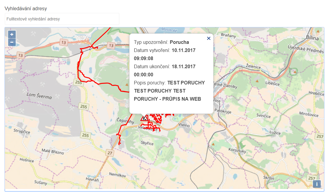
Společně s Vyjadřovacím portálem, který byl ve společnosti implementován za účelem elektronizace a automatizace procesu vyřizování žádostí o vyjádření k existenci sítí, je mapová aplikace poruch a odstávek dalším prostředkem, díky kterému má občan možnost dostat se jednoduše a rychle k požadovaným informacím.
Poruchy a odstávky zveřejňuje Severočeská teplárenská prostřednictvím mapové aplikace
20.11.2017 10:52 GIS FórumPoruchy a odstávky zveřejňuje Severočeská teplárenská prostřednictvím mapové aplikace
20.11.2017 10:52 GIS FórumOmezení provozu 24.11.2017
20.11.2017 9:23 ČÚZK - předpisy a opatření Český úřad zeměměřický a katastrální - Katastrální pracoviště Jindřichův Hradeczveřejnil novou aktualitu: Dne 24.11.2017 v době od 07:30 - 10:30 hod. bude omezen provoz z důvodu přerušení dodávky elektrické energie. V této době nebude možno poskytovat informace z katastru nemovitostí na počkání, žádosti o informace budou přijímány ve formě objednávek. Podání budou přijímána bez přidělení čísla jednacího. Správní poplatek bude možno uhradit pouze formou kolkové známky. Děkujeme za pochopení.
Omezení provozu 24.11.2017
20.11.2017 9:23 ČÚZK - předpisy a opatření Katastrální úřad pro Jihočeský kraj - Katastrální pracoviště Jindřichův Hradeczveřejnil novou aktualitu: Dne 24.11.2017 v době od 07:30 - 10:30 hod. bude omezen provoz z důvodu přerušení dodávky elektrické energie. V této době nebude možno poskytovat informace z katastru nemovitostí na počkání, žádosti o informace budou přijímány ve formě objednávek. Podání budou přijímána bez přidělení čísla jednacího. Správní poplatek bude možno uhradit pouze formou kolkové známky. Děkujeme za pochopení.
Omezení provozu 24.11.2017
20.11.2017 9:23 ČÚZK /Urady/Katastralni-urady/Katastralni-urady/Katastralni-urad-pro-Jihocesky-kraj/Katastralni-pracoviste/KP-Jindrichuv-Hradec/O-uradu/Aktuality/Omezeni-provozu-24-11-2017Co dokážou otevřená data, aneb několik skvělých vizualizací budov v New Yorku
20.11.2017 8:02 GISportal.cz V roce 2013 uvolnila (do té doby se jednalo o placená data) New Yorská radnice datovou sadu PLUTO (Primary Land Use Tax Lot Output), která obsahuje detailní informace o každé parcele v největším americkém městě. ...Carlson Precision 3D Topo 2018 is Here
20.11.2017 4:44 Carlson Software MAYSVILLE, Kentucky, U.S.A. (November 2017) — Carlson Software’s Precision 3D Topo 2018 featuring enhanced visual photographic background, point cloud loading and editing, polyline best fit alignment, and much more has just been released. New 2018 features include enhanced visual Google Maps photographic background, automated Google surface creation, 3D Model editing, polyline editing tools, additional snap modes, and […]INSPIRE Distribution of species of community interest
20.11.2017 1:00 Cenia - Katalog metadat ČR - INSPIRE Distribution of species of community interest is a product of species and habitat surveillance under the obligations of Article 17 of EU Habitats Directive (92/43/ EEC). The species grid distribution (EEA reference grid 1 x 1 km) from data of species reports 2013 is presented. For detailed description and commentary see CHOBOT, K. (ed.) (2016). Druhy a přírodní stanoviště: Hodnotící zprávy o stavu v České republice. Praha: Agentura ochrany přírody a krajiny ČR a Ministerstvo životního prostředí. 226 s. ISBN 978-80-88076-20-9; NCA CR (AOPK ČR), 2013WMS INSPIRE Species distribution (1) Species of community interest
20.11.2017 1:00 Cenia - Katalog metadat ČR - INSPIRE The map service displays - (1) distribution of species of community interest in equal area grid (EEA reference grid, 1 x 1 km grid cell) on the territory of Czechia. The distribution had been compiled from data of Species Reports 2013. © NCA CR (AOPK ČR), 2013Malé družice vyhrály velkou cenu v klání GMES/Copernicus Masters
20.11.2017 0:11 Český Kosmický PortálKonstelace malých družic poskytujících data o ledovcích a vlhkosti v půdě, která by mohla doplnit flotilu satelitů Sentinel, získala nejvyšší cenu v letošním ročníku klání GMES/Copernicus Masters Competition.
Trimble's 3D laser scanning and modeling offers a new way to conduct storage tank inspection in the oil and gas industry
18.11.2017 0:52 GISCafe.com Webcasts-Webinars AUSTIN, Texas, Nov. 17, 2017 — (PRNewswire) — To ensure the most accurate representation of their tank assets and to detect tilt, …TC Technology Hosts Annual Product Advisory Group Meeting
17.11.2017 21:14 GISCafe.com Webcasts-Webinars Carlsbad, CA – November 17, 2017 – TC Technology hosted the 9th annual 2017 PAG on November 8th and 9th in Carlsbad, California. …Thailand Board of Investment (BOI) Introduces New Measures Aimed at Modernizing Agricultural Sector, Enhancing Thailand Competitiveness
17.11.2017 18:06 GISCafe.com Webcasts-Webinars BANGKOK, Nov. 17, 2017 — (PRNewswire) — Agriculture has long been the backbone of Thai economy and remains so today. Looking ahead while …Topcon Agriculture announces TAP, a connected agriculture ecosystem
17.11.2017 18:05 GISCafe.com Webcasts-Webinars TURIN, Italy, Nov. 17, 2017 (GLOBE NEWSWIRE) -- Topcon Agriculture introduces TAP, the Topcon Agriculture Platform, a cloud-based agricultural …Deset let zkoumání hypergravitace s centrifugou ESA
17.11.2017 14:27 Český Kosmický PortálPo čtrnácti miliónech otočkách slaví centrifuga ESA LDC (Large Diameter Centrifuge) své desáté narozeniny. Centrifuga o průměru 8 m a se čteřicí ramen nabízí výzkumníkům přístup k širokému rozsahu hypergravitace až do dvacetinásobku běžné pozemské. A to po dobu týdnů či dokonce měsíců.
Central role for robust GNSS in autonomous driving
17.11.2017 10:31 European GNSS Agency
Scientists and researchers participating at the final event of the EU-funded SaPPART COST Action ('Satellite Positioning Performance Assessment for Road Transport') discussed the potential of GNSS to deliver necessary high-integrity and high-precision positioning capabilities for autonomous road vehicles. A robust centralised on-board GNSS unit could deliver the requisite levels of performance for a variety of in-vehicle applications.
Ifsttar's François Peyret, who served as Chairman of SaPPART, opened the event organised jointly with ERTICO, laying out a core emerging premise for autonomous road transport: "These automatic driving cars will definitely need absolute positioning. They will need a kind of 'box', a GNSS technology, that will provide you with your positioning, with all the required performances. And this will then be hybridised with other kinds of sensors."
SaPPART has been described by organisers as a framework for trans-national cooperation among European researchers, engineers and scholars working in the GNSS and ITS domains, with the common goal of defining requirements for positioning integrity in the road sector. Key areas of interest have included the standardisation and certification of vehicle positioning technologies, the attainment of which is expected to accelerate the uptake of GNSS-based ITS and mobility applications.
SaPPART Science officer Pierre-Yves Gilliéron said, "Positioning is playing a key role for many road and ITS applications such as road user charging. "Our COST Action has been a fantastic tool," he added, "a framework that has been very useful in gathering together researchers and scientists. With SaPPART we have created an international network where we can share knowledge and ideas."
The real challenge, Gilliéron said, was to get the diverse GNSS and ITS communities on the same page, all speaking the same language and understanding each other’s needs. "We received funding for four years and in that time we were able to come closer together and develop a number of clear ideas for common research."
In terms of concrete deliverables, SaPPART has already issued some key reference documents, including a White Paper outlining the basics of GNSS for the ITS audience, as well as a more technically detailed SaPPART Handbook.
"We collected real data sets, carried out testing on-board vehicles, including different GNSS receivers and high-end equipment," said Gilliéron. "In addition to our other publications, the White Paper and the Handbook, a set of Guidelines is now also under preparation on how to assess the quality of positioning in different contexts and for different applications. Those Guidelines will be available by the end of this year."
One thing all seem to be in agreement about – the deployment of autonomous vehicles will soon become a reality on European road networks, and most driving-related decisions will be based, one way or another, on the location of the vehicle and of other vehicles and objects in its vicinity. So vehicle location and positioning will be a critical component for the effective transportation of people and goods by self-driving road vehicles. That positioning will be enabled mainly by GNSS technologies, including Europe’s Galileo, which is expected to offer significant benefits in terms of accuracy and authentication compared to the other satellite-based navigation systems.
View of the European GNSS Agency
"We believe that GNSS is a core technology," said GSA officer Alberto Fernández-Wyttenbach. "It will have to be complimented with other technologies in order to get to the integrity level that we need in 100% of environmental situations, but we also believe GNSS can do more than just navigation. We expect to use it in a very robust way to enable or compliment many other applications."
Fernández said the GSA sees GNSS as an 'engine' for a range of uses within a vehicle: "In commercial vehicles, for example, today there are many applications for which the use of GNSS is particularly relevant."
He also referenced the GNSS-driven smart tachograph, with its enhanced security features, which allows users to pinpoint the geographic location of the vehicle, making compliance easier for operators and facilitating targeted enforcement by authorities throughout the EU.
"We see the convergence with road tolling and fleet management systems that are designed to control the deployment of trucks," Fernández said. "Now instead of having a separate GNSS unit for each of these applications, we understand that you could have one single on-board GNSS monitoring system that could provide positioning for all of them. And you would thereby save on costs."
There are barriers, he said, including the fact that commercial GNSS equipment manufacturers are not necessarily using the best quality chipsets at this time. "That means we may need to rely on more expensive sensor technologies to give us the required precision and integrity," Fernández said. "On the other hand, if we can push for a more advanced, more precise GNSS receiver, such as a multi-constellation and multi-frequency receiver, we could save some of the money that would otherwise go to other types of sensors."
Regardless of what kind of GNSS device finds its way into autonomous vehicles, there will always be some inherent weaknesses associated with satellite-based navigation, Fernández acknowledged. GNSS signals are comparatively weak and do not penetrate buildings such as multi-story car parks or inside tunnels, and there are issues of reflectivity and satellite visibility in built-up urban areas. Other potential problems include vulnerability to intentional and unintentional signal interferences.
These potential problems can be overcome, as already suggested, by hybridization with other positioning sensors and highly accurate digital maps. These techniques, it is hoped, will ultimately provide a seamless position fixing capability while moving between outdoor and indoor environments.
"Ubiquitous positioning is a serious challenge if you want to be able to work in different environments and keep the same level of integrity," said Fernández. "But the combination of GNSS with other technologies, such as simultaneous localization and mapping (SLAM) and also inertial systems will allow us to overcome these problems."
And there will be more high-accuracy GNSS services, he said. "We have in front of us the Galileo Commercial Service that is going to provide, starting at the beginning, high accuracy positioning. Then, in a second phase, the CS will provide an extra authentication feature that will tell you whether the signal is actually coming from a satellite or from some other source."
Cyber security is also being addressed, he said: "The basic message is if you want to go for the use of GNSS, in a regulated way, in autonomous driving, we need to think about the cyber security aspects and the industry will demand solutions that are providing authentication of the satellite signal."
Seeking more input
In an important announcement, Fernández said the European Commission, along with the GSA, has decided to create a new European consultation platform for GNSS applications. "In the United States you have the so-called Civil GPS Service Interface Committee that basically is providing the opinion of the different communities. So in this same way we have designed the concept of the 'European GNSS User Consultation Platform', which will systematically gather opinions, not just from the transport modes but also in the professional market."
The platform, he said, will be divided into subgroups represent the mass market, the professional market and other segments, with a plenary to bring them all together. "There will of course be a panel for transport, including a section on road transport," said Fernandez.
"We need and want to know what the user's needs in the market are, in order to improve our services and develop our thinking about future evolutions. And really that’s the aim of this group, to contribute on the future of GNSS and the Galileo system."
The first meeting of the new European GNSS User Consultation Platform is set to take place on 28 November in Madrid, and the GSA says it is hoping to hear much more from, among others, the participants who worked with so much energy under the SaPPART initiative.
Media note: This feature can be republished without charge provided the European GNSS Agency (GSA) is acknowledged as the source at the top or the bottom of the story. You must request permission before you use any of the photographs on the site. If you republish, we would be grateful if you could link back to the GSA website (http://www.gsa.europa.eu).
Panzura and Frame Partner to Accelerate Global, Real-Time Collaboration for Virtual Workspaces
17.11.2017 3:46 GISCafe.com Webcasts-Webinars Customers dramatically improve productivity, getting multi-million dollar design projects out on time and on budget while reducing storage costs up …Esri Supports American Association of Geographers’ Successful Introduction of Geospatial Data Act
17.11.2017 3:45 GISCafe.com Webcasts-Webinars Legislation Provides Significant Step toward National Collaborationamong the GIS Community
REDLANDS, Calif. — (BUSINESS WIRE) …
Global Mapper SDK Now Available on Amazon Web Services
17.11.2017 1:35 GISCafe.com Webcasts-Webinars Hallowell, Maine - November 16, 2017 - Blue Marble Geographics (bluemarblegeo.com) is pleased to announce that the Global Mapper Software …Konala se vernisáž výstavy Okem dronu na Krajském úřadě Libereckého kraje
16.11.2017 20:23 UpVision Minulý týden se konala na Krajském úřadě Libereckého kraje vernisáž k výstavě Okem dronu s našimi leteckými fotografiemi z celého Česka za velké účasti. Děkujeme moc za spolupráci Ireně Koškové.Několik fotografií zde:
https://plus.google.com/u/0/b/115833877689730865211/+UpvisionCz1/posts/Y3sKYR6qKeD
KOKEŠ a PROLAND verze 13.22
16.11.2017 16:33 GEPROZveřejnili jsme verzi 13.22 našich produktů KOKEŠ a PROLAND.
Stahovat ji můžete z obvyklého umístění na našem download serveru:
Podrobný výčet novinek naleznete v přehledech změn u jednotlivých produktů:
… >>20171116 Odborný referent/vrchní referent oddělení aktualizace popisných informací katastru nemovito
16.11.2017 14:56 ČÚZK /Urady/Katastralni-urady/Katastralni-urady/Katastralni-urad-pro-Stredocesky-kraj/Katastralni-pracoviste/KP-Praha-vychod/O-uradu/Aktuality/20161013Rada-odborny-rada-–-informatik-(3)20171116 Odborný referent/vrchní referent oddělení aktualizace popisných informací katastru nemovito
16.11.2017 14:56 ČÚZK - předpisy a opatření Katastrální úřad pro Středočeský kraj - Katastrální pracoviště Praha-východ Vyhlášení výběrového řízení: Odborný referent/vrchní referent oddělení aktualizace popisných informací katastru nemovitostí I. V části "Úřední deska", v sekci "Oznámení a jiná úřední sdělení" bylo vystaveno "Oznámení o vyhlášení výběrového řízení na obsazení služebního místa Odborný referent/vrchní referent oddělení aktualizace popisných informací katastru nemovitostí I."Odborný referent/vrchní referent oddělení aktualizace popisných informací katastru nemovitostí I.
16.11.2017 14:50 ČÚZK /Urady/Katastralni-urady/Katastralni-urady/Katastralni-urad-pro-Stredocesky-kraj/Uredni-deska/Oznameni-a-jina-uredni-sdeleni/Volna-mista/Odborny-referent-vrchni-referent-oddeleni-aktu-(1)Odborný referent/vrchní referent oddělení aktualizace popisných informací katastru nemovitostí I.
16.11.2017 14:50 ČÚZK - volná místa Katastrální úřad pro Ústecký kraj - Katastrální pracoviště Praha-východ vypisuje výběrové řízení na místo Odborný referent/vrchní referent oddělení aktualizace popisných informací katastru nemovitostí I.Odborný referent/vrchní referent oddělení aktualizace popisných informací katastru nemovitostí I.
16.11.2017 14:50 ČÚZK - předpisy a opatření Katastrální úřad pro Středočeský kraj - Katastrální pracoviště Praha-východvypisuje výběrové řízení na místo Odborný referent/vrchní referent oddělení aktualizace popisných informací katastru nemovitostí I.
Odborný referent/vrchní referent oddělení aktualizace popisných informací katastru nemovitostí I.
Odborný referent/vrchní referent oddělení aktualizace popisných informací katastru nemovitostí I.
16.11.2017 14:50 ČÚZK - předpisy a opatření Katastrální úřad pro Ústecký kraj - Katastrální pracoviště Praha-východvypisuje výběrové řízení na místo Odborný referent/vrchní referent oddělení aktualizace popisných informací katastru nemovitostí I.
Odborný referent/vrchní referent oddělení aktualizace popisných informací katastru nemovitostí I.
Odborný referent/vrchní referent oddělení aktualizace popisných informací katastru nemovitostí I.
16.11.2017 14:50 ČÚZK - volná místa Katastrální úřad pro Středočeský kraj - Katastrální pracoviště Praha-východ vypisuje výběrové řízení na místo Odborný referent/vrchní referent oddělení aktualizace popisných informací katastru nemovitostí I.Stakeholder Consultation GSA/SC/30/17 on Galileo Commercial Service High Accuracy Provision
16.11.2017 14:41 European GNSS Agency
Ongoing discussions between stakeholders of the Galileo Programme have outlined the opportunity to consider offering the High Accuracy Commercial Service (HA CS) to all interested users on a free of charge basis, with content and format of data publicly and openly available on a global scale. This approach would increase the public benefit delivered by Galileo, contributing to its positioning in the market as the first GNSS system offering high accuracy services on a free of charge basis. At the same time, since departing from the scheme originally foreseen by Implementing Decision (EU) 2017/2243 of 8 February 2017, the possibility to provide HA CS on a free of charge and global basis needs to be carefully assessed in many respects. The results of the consultation may be used to support the change of the Implementing Decision. On this basis, preparation and conduct of a procurement procedure for Commercial Service provision may be initiated by the GSA. For the avoidance of doubt this stakeholder consultation shall not create any obligation on the GSA as to possible follow-up procurements.
All organisations, economic operators and members of the public with a personal or professional interest in Galileo Commercial Service, are invited to express their opinion, experience and expectations with the various aspects of the Galileo Commercial Service provision.
Further information on the Consultation is provided here.
Deadline for submission : 30 November 2017
Media note: This feature can be republished without charge provided the European GNSS Agency (GSA) is acknowledged as the source at the top or the bottom of the story. You must request permission before you use any of the photographs on the site. If you republish, we would be grateful if you could link back to the GSA website (http://www.gsa.europa.eu).
Stakeholder Consultation GSA/SC/30/17 on Galileo Commercial Service High Accuracy Provision
16.11.2017 14:41 European GNSS AgencyOngoing discussions between stakeholders of the Galileo Programme have outlined the opportunity to consider offering the High Accuracy Commercial Service (HA CS) to all interested users on a free of charge basis, with content and format of data publicly and openly available on a global scale.
This approach would increase the public benefit delivered by Galileo, contributing to its positioning in the market as the first GNSS system offering high accuracy services on a free of charge basis. At the same time, since departing from the scheme originally foreseen by Implementing Decision (EU) 2017/2243 of 8 February 2017, the possibility to provide HA CS on a free of charge and global basis needs to be carefully assessed in many respects. The results of the consultation may be used to support the change of the Implementing Decision. On this basis, preparation and conduct of a procurement procedure for Commercial Service provision may be initiated by the GSA. For the avoidance of doubt this stakeholder consultation shall not create any obligation on the GSA as to possible follow-up procurements.
All organisations, economic operators and members of the public with a personal or professional interest in Galileo Commercial Service, are invited to express their opinion, experience and expectations with the various aspects of the Galileo Commercial Service provision.
Further information on the Consultation is provided here.
Deadline for submission : 7 December 2017
Media note: This feature can be republished without charge provided the European GNSS Agency (GSA) is acknowledged as the source at the top or the bottom of the story. You must request permission before you use any of the photographs on the site. If you republish, we would be grateful if you could link back to the GSA website (http://www.gsa.europa.eu).
Stakeholder Consultation GSA/SC/30/17 on Galileo Commercial Service High Accuracy Provision
16.11.2017 14:41 European GNSS AgencyOngoing discussions between stakeholders of the Galileo Programme have outlined the opportunity to consider offering the High Accuracy Commercial Service (HA CS) to all interested users on a free of charge basis, with content and format of data publicly and openly available on a global scale. This approach would increase the public benefit delivered by Galileo, contributing to its positioning in the market as the first GNSS system offering high accuracy services on a free of charge basis. At the same time, since departing from the scheme originally foreseen by Implementing Decision (EU) 2017/2243 of 8 February 2017, the possibility to provide HA CS on a free of charge and global basis needs to be carefully assessed in many respects. The results of the consultation may be used to support the change of the Implementing Decision. On this basis, preparation and conduct of a procurement procedure for Commercial Service provision may be initiated by the GSA. For the avoidance of doubt this stakeholder consultation shall not create any obligation on the GSA as to possible follow-up procurements.
All organisations, economic operators and members of the public with a personal or professional interest in Galileo Commercial Service, are invited to express their opinion, experience and expectations with the various aspects of the Galileo Commercial Service provision.
Further information on the Consultation is provided here.
Deadline for submission : 30 November 2017
Media note: This feature can be republished without charge provided the European GNSS Agency (GSA) is acknowledged as the source at the top or the bottom of the story. You must request permission before you use any of the photographs on the site. If you republish, we would be grateful if you could link back to the GSA website (http://www.gsa.europa.eu).
Družice navigují lodě v ledových vodách i skrze oblačnost
16.11.2017 14:25 Český Kosmický PortálKoncem srpna dokončil šedesát metrů dlouhý kutr americké pobřežní stráže Maple svoji navigaci skrze arktickou ledem pokrytou severní cestu. Nešlo o první využití této cesty lodní dopravou, ale bylo to poprvé, co mezinárodní ledová hlídka IIP (International Ice Patrol) poskytovala lodi informace o ledovcích, které byly založené výhradně na družicovém snímkování.
Panzura and Frame Partner to Accelerate Global, Real-Time Collaboration for Virtual Workspaces
16.11.2017 12:46 GISCafe.com Webcasts-Webinars Customers dramatically improve productivity, getting multi-million dollar design projects out on time and on budget while reducing storage costs up …Odborný referent – obnova katastrálního operátu na Katastrálním pracovišti Třinec Katastrálního úřad
16.11.2017 12:38 ČÚZK /Urady/Katastralni-urady/Katastralni-urady/Katastralni-urad-pro-Moravskoslezsky-kraj/Uredni-deska/Oznameni-a-jina-uredni-sdeleni/Volna-mista/Odborny-referent-–-obnova-katastralniho-operatu-naOdborný referent – obnova katastrálního operátu na Katastrálním pracovišti Třinec Katastrálního úřad
16.11.2017 12:38 ČÚZK - volná místa Katastrální úřad pro Moravskoslezský kraj - Katastrální pracoviště Třinec vypisuje výběrové řízení na místo Odborný referent – obnova katastrálního operátu na Katastrálním pracovišti Třinec Katastrálního úřadOdborný referent – obnova katastrálního operátu na Katastrálním pracovišti Třinec Katastrálního úřad
16.11.2017 12:38 ČÚZK - předpisy a opatření Katastrální úřad pro Moravskoslezský kraj - Katastrální pracoviště Třinecvypisuje výběrové řízení na místo odborný referent – obnova katastrálního operátu na Katastrálním pracovišti Třinec Katastrálního úřadu pro Moravskoslezský kraj
Odborný referent – obnova katastrálního operátu na Katastrálním pracovišti Třinec Katastrálního úřadu pro Moravskoslezský kraj
Odborný referent – zápisy v řízení V a Z na Katastrálním pracovišti Krnov Katastrálního úřadu pro Mo
16.11.2017 12:35 ČÚZK /Urady/Katastralni-urady/Katastralni-urady/Katastralni-urad-pro-Moravskoslezsky-kraj/Uredni-deska/Oznameni-a-jina-uredni-sdeleni/Volna-mista/Odborny-referent-–-zapisy-v-rizeni-V-a-Z-na-KatastOdborný referent – zápisy v řízení V a Z na Katastrálním pracovišti Krnov Katastrálního úřadu pro Mo
16.11.2017 12:35 ČÚZK - předpisy a opatření Katastrální úřad pro Moravskoslezský kraj - Katastrální pracoviště Krnovvypisuje výběrové řízení na místo odborný referent – zápisy v řízení V a Z na Katastrálním pracovišti Krnov Katastrálního úřadu pro Moravskoslezský kraj
Odborný referent – zápisy v řízení V a Z na Katastrálním pracovišti Krnov Katastrálního úřadu pro Moravskoslezský kraj
Odborný referent – zápisy v řízení V a Z na Katastrálním pracovišti Krnov Katastrálního úřadu pro Mo
16.11.2017 12:35 ČÚZK - volná místa Katastrální úřad pro Moravskoslezský kraj - Katastrální pracoviště Krnov vypisuje výběrové řízení na místo Odborný referent – zápisy v řízení V a Z na Katastrálním pracovišti Krnov Katastrálního úřadu pro MoVrchní referent/rada – obnova katastrálního operátu na Katastrálním pracovišti Frýdek – Místek Katas
16.11.2017 12:32 ČÚZK - předpisy a opatření Katastrální úřad pro Moravskoslezský kraj - Katastrální pracoviště Frýdek-Místekvypisuje výběrové řízení na místo vrchní referent/rada – obnova katastrálního operátu na Katastrálním pracovišti Frýdek – Místek Katastrálního úřadu pro Moravskoslezský kraj
Vrchní referent/rada – obnova katastrálního operátu na Katastrálním pracovišti Frýdek – Místek Katastrálního úřadu pro Moravskoslezský kraj
Vrchní referent/rada – obnova katastrálního operátu na Katastrálním pracovišti Frýdek – Místek Katas
16.11.2017 12:32 ČÚZK /Urady/Katastralni-urady/Katastralni-urady/Katastralni-urad-pro-Moravskoslezsky-kraj/Uredni-deska/Oznameni-a-jina-uredni-sdeleni/Volna-mista/Vrchni-referent-rada-–-obnova-katastralniho-op-(1)Vrchní referent/rada – obnova katastrálního operátu na Katastrálním pracovišti Frýdek – Místek Katas
16.11.2017 12:32 ČÚZK - volná místa Katastrální úřad pro Moravskoslezský kraj - Katastrální pracoviště Frýdek-Místek vypisuje výběrové řízení na místo Vrchní referent/rada – obnova katastrálního operátu na Katastrálním pracovišti Frýdek – Místek KatasOdborný referent/vrchní referent – zápisy v řízení V a Z na Katastrálním pracovišti Frýdek – Místek
16.11.2017 12:31 ČÚZK - volná místa Katastrální úřad pro Moravskoslezský kraj - Katastrální pracoviště Frýdek-Místek vypisuje výběrové řízení na místo Odborný referent/vrchní referent – zápisy v řízení V a Z na Katastrálním pracovišti Frýdek – MístekOdborný referent/vrchní referent – zápisy v řízení V a Z na Katastrálním pracovišti Frýdek – Místek
16.11.2017 12:31 ČÚZK /Urady/Katastralni-urady/Katastralni-urady/Katastralni-urad-pro-Moravskoslezsky-kraj/Uredni-deska/Oznameni-a-jina-uredni-sdeleni/Volna-mista/Odborny-referent-vrchni-referent-–-zapisy-v-rizeniOdborný referent/vrchní referent – zápisy v řízení V a Z na Katastrálním pracovišti Frýdek – Místek
16.11.2017 12:31 ČÚZK - předpisy a opatření Katastrální úřad pro Moravskoslezský kraj - Katastrální pracoviště Frýdek-Místekvypisuje výběrové řízení na místo odborný referent/vrchní referent – zápisy v řízení V a Z na Katastrálním pracovišti Frýdek – Místek Katastrálního úřadu pro Moravskoslezský kraj
Odborný referent/vrchní referent – zápisy v řízení V a Z na Katastrálním pracovišti Frýdek – Místek Katastrálního úřadu pro Moravskoslezský kraj
Salar de Atacama
16.11.2017 12:31 ESA Observing the Earth
Earth observation image of the week: Sentinel-2 takes us over part of the Atacama Desert in northern Chile
Earth from Space
16.11.2017 12:29 ESA Observing the Earth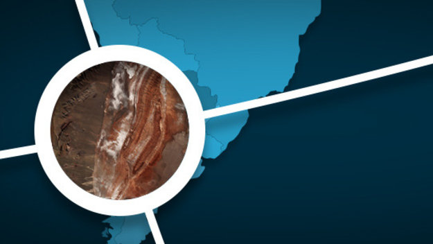
In the 248th edition, discover Chile’s largest salt flat in the Atacama Desert
vrchní referent/rada – správa dokumentace katastru na Katastrálním pracovišti Frýdek – Místek Katast
16.11.2017 11:32 ČÚZK /Urady/Katastralni-urady/Katastralni-urady/Katastralni-urad-pro-Moravskoslezsky-kraj/Uredni-deska/Oznameni-a-jina-uredni-sdeleni/Volna-mista/vrchni-referent-rada-–-sprava-dokumentace-katastruVrchní referent/rada – správa dokumentace katastru na Katastrálním pracovišti Frýdek – Místek Katast
16.11.2017 11:32 ČÚZK /Urady/Katastralni-urady/Katastralni-urady/Katastralni-urad-pro-Moravskoslezsky-kraj/Uredni-deska/Oznameni-a-jina-uredni-sdeleni/Volna-mista/vrchni-referent-rada-–-sprava-dokumentace-katastruVrchní referent/rada – správa dokumentace katastru na Katastrálním pracovišti Frýdek – Místek Katast
16.11.2017 11:32 ČÚZK - předpisy a opatření Katastrální úřad pro Moravskoslezský kraj - Katastrální pracoviště Frýdek-Místekvypisuje výběrové řízení na místo vrchní referent/rada – správa dokumentace katastru na Katastrálním pracovišti Frýdek – Místek Katastrálního úřadu pro Moravskoslezský kraj
Vrchní referent/rada – správa dokumentace katastru na Katastrálním pracovišti Frýdek – Místek Katastrálního úřadu pro Moravskoslezský kraj
vrchní referent/rada – správa dokumentace katastru na Katastrálním pracovišti Frýdek – Místek Katast
16.11.2017 11:32 ČÚZK - předpisy a opatření Katastrální úřad pro Moravskoslezský kraj - Katastrální pracoviště Frýdek-Místekvypisuje výběrové řízení na místo vrchní referent/rada – správa dokumentace katastru na Katastrálním pracovišti Frýdek – Místek Katastrálního úřadu pro Moravskoslezský kraj
vrchní referent/rada – správa dokumentace katastru na Katastrálním pracovišti Frýdek – Místek Katastrálního úřadu pro Moravskoslezský kraj
Vrchní referent/rada – správa dokumentace katastru na Katastrálním pracovišti Frýdek – Místek Katast
16.11.2017 11:32 ČÚZK - volná místa Katastrální úřad pro Moravskoslezský kraj - Katastrální pracoviště Frýdek-Místek vypisuje výběrové řízení na místo Vrchní referent/rada – správa dokumentace katastru na Katastrálním pracovišti Frýdek – Místek Katastvrchní referent/rada – správa dokumentace katastru na Katastrálním pracovišti Frýdek – Místek Katast
16.11.2017 11:32 ČÚZK - volná místa Katastrální úřad pro Moravskoslezský kraj - Katastrální pracoviště Frýdek-Místek vypisuje výběrové řízení na místo vrchní referent/rada – správa dokumentace katastru na Katastrálním pracovišti Frýdek – Místek KatastRada/odborný rada – projekty a výstupní kontrola v technickém odboru
16.11.2017 11:29 ČÚZK - předpisy a opatření Katastrální úřad pro Moravskoslezský krajvypisuje výběrové řízení na místo rada/odborný rada – projekty a výstupní kontrola v technickém odboru
Rada/odborný rada – projekty a výstupní kontrola v technickém odboru
Rada/odborný rada – projekty a výstupní kontrola v technickém odboru Katastrálního úřadu pro Moravsk
16.11.2017 11:29 ČÚZK /Urady/Katastralni-urady/Katastralni-urady/Katastralni-urad-pro-Moravskoslezsky-kraj/Uredni-deska/Oznameni-a-jina-uredni-sdeleni/Volna-mista/Rada-odborny-rada-–-projekty-a-vystupni-kontrola-vRada/odborný rada – projekty a výstupní kontrola v technickém odboru
16.11.2017 11:29 ČÚZK /Urady/Katastralni-urady/Katastralni-urady/Katastralni-urad-pro-Moravskoslezsky-kraj/Uredni-deska/Oznameni-a-jina-uredni-sdeleni/Volna-mista/Rada-odborny-rada-–-projekty-a-vystupni-kontrola-vRada/odborný rada – projekty a výstupní kontrola v technickém odboru
16.11.2017 11:29 ČÚZK - volná místa Katastrální úřad pro Moravskoslezský kraj vypisuje výběrové řízení na místo Rada/odborný rada – projekty a výstupní kontrola v technickém odboruRada/odborný rada – projekty a výstupní kontrola v technickém odboru Katastrálního úřadu pro Moravsk
16.11.2017 11:29 ČÚZK - předpisy a opatření Katastrální úřad pro Moravskoslezský krajvypisuje výběrové řízení na místo rada/odborný rada – projekty a výstupní kontrola v technickém odboru
Rada/odborný rada – projekty a výstupní kontrola v technickém odboru Katastrálního úřadu pro Moravskoslezský kraj
Rada/odborný rada – projekty a výstupní kontrola v technickém odboru Katastrálního úřadu pro Moravsk
16.11.2017 11:29 ČÚZK - volná místa Katastrální úřad pro Moravskoslezský kraj vypisuje výběrové řízení na místo Rada/odborný rada – projekty a výstupní kontrola v technickém odboru Katastrálního úřadu pro MoravskVrchní referent/rada – obnova katastrálního operátu v technickém odboru Katastrálního úřadu pro Mora
16.11.2017 11:23 ČÚZK - volná místa Katastrální úřad pro Moravskoslezský kraj vypisuje výběrové řízení na místo Vrchní referent/rada – obnova katastrálního operátu v technickém odboru Katastrálního úřadu pro MoraVrchní referent/rada – obnova katastrálního operátu v technickém odboru Katastrálního úřadu pro Mora
16.11.2017 11:23 ČÚZK - předpisy a opatření Katastrální úřad pro Moravskoslezský krajvypisuje výběrové řízení na místo vrchní referent/rada – obnova katastrálního operátu v technickém odboru Katastrálního úřadu pro Moravskoslezský kraj
Vrchní referent/rada – obnova katastrálního operátu v technickém odboru Katastrálního úřadu pro Moravskoslezský kraj
Vrchní referent/rada – obnova katastrálního operátu v technickém odboru Katastrálního úřadu pro Mora
16.11.2017 11:23 ČÚZK /Urady/Katastralni-urady/Katastralni-urady/Katastralni-urad-pro-Moravskoslezsky-kraj/Uredni-deska/Oznameni-a-jina-uredni-sdeleni/Volna-mista/Vrchni-referent-rada-–-obnova-katastralniho-operatDaily Planet Imagery Now Available in SpyMeSat Mobile App
16.11.2017 11:20 GISCafe.com Webcasts-Webinars GREENBELT, MD (November 15, 2017) – Orbit Logic has reached an agreement with Planet Labs, Inc. that allows SpyMeSat mobile app users to access …GSA launches Galileo test campaign for GIS grade receivers
16.11.2017 10:48 European GNSS Agency
GSA is reaching out to receivers manufactures with a Galileo test campaign for GIS grade receivers. Receivers will be tested using Signal in Space, and comparing GNSS constellations or their combinations both in a single frequency and dual frequency mode.
The European GNSS Agency (GSA) has officially launched the Galileo test campaign for GIS grade receivers with the main objective to evaluate the receivers` performance, highlighting the added value of Galileo system for GIS Data Collection.
Testing with GSA provides, among others, the following advantages:
- Independent tests: GSA will conduct neutral tests and provide objective results.
- Flexible test cases: GSA can modify or add new test cases depending on the manufacturer's needs.
- Two facilities equipped with state-of-the-art tools and instruments: GSA is collaborating with two laboratories (one at Thales Alenia Space Italy and the other at Airbus Defense and Space) to carry out the test cases.
- Free of cost: The tests are completely free of charge to the manufacturers as the aim of the campaign is to support to the industry to leverage the benefits of Galileo.
- Anonymous comparison of results: GSA provides the opportunity to compare results with other manufacturers in an anonymous way.
The scenarios of interest will be tested comparing the different GNSS constellations and their combinations both in a single frequency and dual frequency mode. All receivers will be tested using GNSS Signal in Space, so the test execution will be performed in parallel running all the receivers under test at the same time for each test case.
The tests will assess:
- positioning accuracy under different conditions
- time-to-first-fix
- tracking capability
Sign up today!
Manufacturers are encouraged to take advantage of this opportunity, which is completely free-of-charge and on a voluntary basis. All results will be kept confidential and covered by individual non-disclosure agreements. For more information, contact the GSA Market Development Department (market@gsa.europa.eu) no later than 1 December 2017.
Media note: This feature can be republished without charge provided the European GNSS Agency (GSA) is acknowledged as the source at the top or the bottom of the story. You must request permission before you use any of the photographs on the site. If you republish, we would be grateful if you could link back to the GSA website (http://www.gsa.europa.eu).
thinkWhere Powers Humanitarian Disaster Response with OpenStreetMap Management Tool
16.11.2017 9:00 GISCafe.com Webcasts-Webinars Nov 16, 2017 -- Scottish GIS company, thinkWhere, is playing a vital role in enabling the delivery of emergency response and aid to areas hit by …Odborný rada – vedoucí oddělení právních vztahů k nemovitostem
16.11.2017 8:54 ČÚZK - volná místa Katastrální úřad pro Moravskoslezský kraj - Katastrální pracoviště Krnov vypisuje výběrové řízení na místo Odborný rada – vedoucí oddělení právních vztahů k nemovitostemOdborný rada – vedoucí oddělení právních vztahů k nemovitostem
16.11.2017 8:54 ČÚZK - předpisy a opatření Katastrální úřad pro Moravskoslezský kraj - Katastrální pracoviště Krnovvypisuje výběrové řízení na místo odborný rada – vedoucí oddělení právních vztahů k nemovitostem
Odborný rada – vedoucí oddělení právních vztahů k nemovitostem
Odborný rada – vedoucí oddělení právních vztahů k nemovitostem
16.11.2017 8:54 ČÚZK /Urady/Katastralni-urady/Katastralni-urady/Katastralni-urad-pro-Moravskoslezsky-kraj/Uredni-deska/Oznameni-a-jina-uredni-sdeleni/Volna-mista/Odborny-rada-–-vedouci-oddeleni-pravnich-vztah-(2)GIS bez DPZ a umelé inteligence? Nemožné!
16.11.2017 8:39 Blogující geomatici - FAV ZČUTitulkem jsem se snažil shrnout obsah velmi zajímavého článku na serveru geoawesomeness.com:
The perfect storm called artificial intelligence and geospatial big data, který popisuje několik velmi zajímavých analýz velmi velkých DPZ dat.
Nová verze CityEngine 2017.1
16.11.2017 7:34 GISportal.cz Tento týden vyšla nová verze CityEngine s číslem 2017.1. Mezi hlavní novinky této verze patří analýzy viditelnosti pro plánování měst. Tyto analýzy lze využít například k posouzení výhledu z nově plánované bytové výstavby, nebo ke zjištění, ...Sustainable Mining Through Geomorphic Rehabilitation Seminar, Nov. 24
16.11.2017 6:14 Carlson Software Associate Professor José F. Martin Duque of the Complutense University of Madrid, Spain, will be presenting a free seminar entitled “Sustainable Mining through Geomorphic Rehabilitation Examples from the European Union and South America” on Friday, November 24, at the University of Newcastle in Callaghan, New South Wales, Australia. The seminar will begin at 2:15 p.m. […]New Precise Point Positioning Module comes to Carlson SurveyGNSS
16.11.2017 2:14 Carlson Software MAYSVILLE, Kentucky, U.S.A. (November 2017) — Carlson SurveyGNSS, Carlson Software’s simple, yet powerful data post-processing software, is now enhanced by Precise Point Positioning (PPP) as an add-on module. With the new Carlson module, PPP, users can post-process using a single receiver. PPP adds precise GNSS station positioning capabilities for a single GNSS receiver operating autonomously. […]Autodesk and Esri Partnering to Advance Infrastructure Planning and Design
16.11.2017 1:48 GISCafe.com Webcasts-Webinars Global Geographic Information System & Building Information Modeling Leaders Plan to Drive Integration of Spatial Intelligence and 3D Design …Geomni’s UAV Solution Serves to Solve Tree Coverage Imagery Problem
16.11.2017 1:17 GISCafe.com Webcasts-Webinars Lehi, Utah, Nov 15, 2017 — Overreaching tree canopies can obscure details of residential and commercial structures from satellite and aerial …Mappt Elements Debuts Free Geospatial Mapping App That Provides Free Access to Over 330,000 USGS GeoPDFs
16.11.2017 1:14 GISCafe.com Webcasts-Webinars Nov 15, 2017 -- Mappt Elements, a free data collection and mapping iOS application, has just released a feature that enables GeoPDFs to be added to a …Halifax Regional Municipality Recognized for Improving Operations Using GIS
16.11.2017 1:13 GISCafe.com Webcasts-Webinars HALIFAX, Esri Canada User Conference -November 15, 2017 – The Halifax Regional Municipality today received Esri Canada’s Award of …Avenza Releases MAPublisher 10 For Adobe Illustrator
16.11.2017 1:10 GISCafe.com Webcasts-Webinars Adobe CC 2018 compatibility and data link managementToronto, ON, November 15, 2017 – Avenza Systems Inc., producers of the Avenza …
Báňské mapy
16.11.2017 1:00 Cenia - Katalog metadat ČR - INSPIRE Databáze obsahuje dokumentografické záznamy o báňských mapách uložených v archivu na pracovišti ČGS v Kutné Hoře. Od roku 1990 byly údaje o těchto mapách zpracovávány do databáze, která prošla od svého vzniku řadou úprav a modernizací.Báňské mapy
16.11.2017 1:00 Cenia - Katalog metadat ČR - INSPIRE Mapová aplikace zpřístupňuje náhledy skenů a informace o báňských mapách z území ČR, evidovaných na pracovišti ČGS v Kutné Hoře.Community Map of Canada Now Available
16.11.2017 0:32 GISCafe.com Webcasts-Webinars TORONTO, November 15, 2017 – To celebrate Geography Awareness Week and Geographic Information Systems (GIS) Day today, Esri Canada invites …Luciad Launches V2017.1: The Next Generation of Geospatial Situational Awareness
16.11.2017 0:00 GISCafe.com Webcasts-Webinars Leuven, Belgium, Nov 15, 2017 - Luciad, a world leader in high performance geospatial applications, is proud to announce its new V2017.1 version of …Oznámení o vyhlášení výběrového řízení na služební místo vrchní referent / rada oddělení rozpočtu
16.11.2017 0:00 Státní pozemkový úřad Ústřední ředitelka Státního pozemkového úřadu, jako služební orgán příslušný podle § 10 odst. 1 písm. f) zákona č. 234/2014 Sb., o státní službě (dále jen „zákon“), vyhlašuje výběrové řízení na služební místo vrchní referent / rada oddělení rozpočtu.Oznámení o vyhlášení výběrového řízení na služební místo vrchní referent/rada oddělení půdní služby České Budějovice, odbor půdní služby
16.11.2017 0:00 Státní pozemkový úřad Ústřední ředitelka Státního pozemkového úřadu, jako služební orgán příslušný podle § 10 odst. 1 písm. f) zákona č. 234/2014 Sb., o státní službě (dále jen „zákon“), vyhlašuje výběrové řízení na služební místo vrchní referent/rada oddělení půdní služby České Budějovice, odbor půdní služby.Orbit GT releases 3D Mapping Feature Extraction Standard v18
15.11.2017 23:20 GISCafe.com Webcasts-Webinars Orbit GT launches the 3D Mapping Feature Extraction Standard product version 18.Lokeren, Belgium, Nov 15, 2017 -- “We’re pleased …
Oznámena spolupráce Autodesk a Esri v oblasti BIM a GIS
15.11.2017 20:46 GIS Fórum Úvodní přednáška druhého dne konference Autodesk University v Las Vegas měla možná trochu překvapivého hosta. CEO Autodesku, Andrew Anagnost, na pódiu přivítal šéfa a zakladatele společnosti Esri, Jacka Dangermonda. Společně pak představili strategickou spolupráci obou firem.Společnosti Autodesk a Esri, globální lídři v oblasti BIM a GIS, se dohodli na spolupráci a podpoře integrace prostorové inteligence s 3D daty informačního modelu budov. Tato spolupráce je určena k vybudování mostu mezi technologiemi BIM a GIS mapování. Tím, že budou data BIM a GIS v centru projektů, mohou majitelé infrastruktury a jejich poskytovatelé inženýrských služeb:
- Optimalizovat způsoby jakými plánují, navrhují, vytvářejí a provozují prostředky infrastruktury a činit inteligentnější rozhodnutí, optimalizovat návrhy, urychlit schvalování projektů a snížit náklady.
- Získat lepší kontext projektu - jak zapadá a interaguje s okolním ekosystémem, a tím lépe porozumět jak se přírodní a stávající zastavěné prostředí propojuje s nově budovaným projektem.
- Zaměřit se nejen na to, co navrhnout a postavit, ale také lépe pochopit, kde a proč, a poskytovat tak udržitelnější a odolnější infrastrukturu.


Technologie BIM i GIS sdílejí podobné abstrakce dat, stejně tak jako koncepty LIM a CIM (landscape, city information modeling). Cílem spolupráce je zlepšit sdílení dat GIS a návrhových informací BIM mezi nástroji a technologiemi obou firem - rozvíjet hladší výměnu prostorových a atributových dat typicky zachycených v GIS systémech Esri a v 3D BIM modelech v návrhovém softwaru Autodesku.
Globální trendy vyžadují nové přístupy k plánování a navrhování. GIS a BIM data jsou v centru infrastrukturních projektů - domů, škol, silnic, tranzitních zařízení, kanalizačních a energetických sítí atd. - již je nelze plánovat, navrhovat a stavět izolovaně od jejich okolí, bez posouzení vlivu okolního prostředí.
Již dnes mohou uživatelé AutoCADu využívat modul Esri ArcGIS pro připojení k ArcGIS a obohatit tak CAD výkresy o mapy, letecké snímky a geografické funkce nebo upravovat v AutoCADu GIS data. Podobné nástroje nabízí i AutoCAD Map 3D. Integrace by se měla rozšířit i mezi GIS a BIM nástroji pro projekty infrastruktury a vytvořit tak přímý, oboustranný a hladký tok informací umožňující zákazníkům:
- Nativní přístup ke GIS informacím pro vytváření robustnějších modelů pro plánování, koncepční inženýrství, projektování a provozování.
- Nativní zápis BIM informací do databází ArcGIS pro minimalizaci ztráty dat.
- Nativní přístup k BIM informacím z aplikací ESRI, a poskytnout tak přístup k provozním datům a informacím, které pomáhají při správě majetku.

AutoCAD Map 3D zůstává i nadále řešením Autodesku pro zákazníky, kteří potřebují široký přístup k datům CAD a GIS pro podporu pracovních postupů plánování, návrhu a správy dat. Společnost Autodesk se zavazuje pokračovat v poskytování funkcí 3D platformy, poskytovatele obsahu a správce obsahu, protože aplikace AutoCAD Map 3D slouží jako základní komponenta pro AutoCAD Civil 3D a InfraWorks. Autodesk bude nadále podporovat tento produkt a poskytovat jeho vylepšení (s funkcemi děděnými z AutoCADu), stejně tak jako jeho aktualizace a opravy. Zákazníci mohou s důvěrou využívat nová subscription i obnovy subscription k AutoCADu Map 3D.
Díky užší integraci dat GIS a BIM mohou majitelé staveb a stavební firmy využít silnější vizualizace a simulace, aby vyhodnotili, jak budou prostředky infrastruktury zapadat do kontextu stávajícího životního prostředí. Získají schopnost lépe rozhodovat o tom, kde a jak by měla být vybudována jejich infrastruktura, podnítit chytřejší rozhodnutí, urychlit projekty, snížit náklady, a tvořit chytřejší města a odolnou infrastrukturu.
Oznámena spolupráce Autodesk a Esri v oblasti BIM a GIS
15.11.2017 20:46 GIS Fórum Úvodní přednáška druhého dne konference Autodesk University v Las Vegas měla možná trochu překvapivého hosta. CEO Autodesku, Andrew Anagnost, na pódiu přivítal šéfa a zakladatele společnosti Esri, Jacka Dangermonda. Společně pak představili strategickou spolupráci obou firem.Společnosti Autodesk a Esri, globální lídři v oblasti BIM a GIS, se dohodli na spolupráci a podpoře integrace prostorové inteligence s 3D daty informačního modelu budov. Tato spolupráce je určena k vybudování mostu mezi technologiemi BIM a GIS mapování. Tím, že budou data BIM a GIS v centru projektů, mohou majitelé infrastruktury a jejich poskytovatelé inženýrských služeb:
- Optimalizovat způsoby jakými plánují, navrhují, vytvářejí a provozují prostředky infrastruktury a činit inteligentnější rozhodnutí, optimalizovat návrhy, urychlit schvalování projektů a snížit náklady.
- Získat lepší kontext projektu - jak zapadá a interaguje s okolním ekosystémem, a tím lépe porozumět jak se přírodní a stávající zastavěné prostředí propojuje s nově budovaným projektem.
- Zaměřit se nejen na to, co navrhnout a postavit, ale také lépe pochopit, kde a proč, a poskytovat tak udržitelnější a odolnější infrastrukturu.
Technologie BIM i GIS sdílejí podobné abstrakce dat, stejně tak jako koncepty LIM a CIM (landscape, city information modeling). Cílem spolupráce je zlepšit sdílení dat GIS a návrhových informací BIM mezi nástroji a technologiemi obou firem - rozvíjet hladší výměnu prostorových a atributových dat typicky zachycených v GIS systémech Esri a v 3D BIM modelech v návrhovém softwaru Autodesku.
Globální trendy vyžadují nové přístupy k plánování a navrhování. GIS a BIM data jsou v centru infrastrukturních projektů - domů, škol, silnic, tranzitních zařízení, kanalizačních a energetických sítí atd. - již je nelze plánovat, navrhovat a stavět izolovaně od jejich okolí, bez posouzení vlivu okolního prostředí.
Již dnes mohou uživatelé AutoCADu využívat modul Esri ArcGIS pro připojení k ArcGIS a obohatit tak CAD výkresy o mapy, letecké snímky a geografické funkce nebo upravovat v AutoCADu GIS data. Podobné nástroje nabízí i AutoCAD Map 3D. Integrace by se měla rozšířit i mezi GIS a BIM nástroji pro projekty infrastruktury a vytvořit tak přímý, oboustranný a hladký tok informací umožňující zákazníkům:
- Nativní přístup ke GIS informacím pro vytváření robustnějších modelů pro plánování, koncepční inženýrství, projektování a provozování.
- Nativní zápis BIM informací do databází ArcGIS pro minimalizaci ztráty dat.
- Nativní přístup k BIM informacím z aplikací ESRI, a poskytnout tak přístup k provozním datům a informacím, které pomáhají při správě majetku.
AutoCAD Map 3D zůstává i nadále řešením Autodesku pro zákazníky, kteří potřebují široký přístup k datům CAD a GIS pro podporu pracovních postupů plánování, návrhu a správy dat. Společnost Autodesk se zavazuje pokračovat v poskytování funkcí 3D platformy, poskytovatele obsahu a správce obsahu, protože aplikace AutoCAD Map 3D slouží jako základní komponenta pro AutoCAD Civil 3D a InfraWorks. Autodesk bude nadále podporovat tento produkt a poskytovat jeho vylepšení (s funkcemi děděnými z AutoCADu), stejně tak jako jeho aktualizace a opravy. Zákazníci mohou s důvěrou využívat nová subscription i obnovy subscription k AutoCADu Map 3D.
Díky užší integraci dat GIS a BIM mohou majitelé staveb a stavební firmy využít silnější vizualizace a simulace, aby vyhodnotili, jak budou prostředky infrastruktury zapadat do kontextu stávajícího životního prostředí. Získají schopnost lépe rozhodovat o tom, kde a jak by měla být vybudována jejich infrastruktura, podnítit chytřejší rozhodnutí, urychlit projekty, snížit náklady, a tvořit chytřejší města a odolnou infrastrukturu.