


![]()

zprávy
zdroje zpráv:Nová pracovní nabídka v Olomouci
25.11.2017 8:10 GISportal.cz Olomoucká společnost Atomicon hledá obchodního manažera se zaměřením na GIS. Prý vhodné i pro absolventy.PlanetObserver presents new PlanetSAT Updates imagery basemap of the United States and Mexico
24.11.2017 19:35 GISCafe.com Webcasts-Webinars Clermont-Ferrand, France - April 26th 2017 - The French company PlanetObserver, specialized in geospatial data production, has just finalized …New user-friendly app provides detailed digital maps and real-time GPS pinpointing
24.11.2017 19:35 GISCafe.com Webcasts-Webinars Whistler, BC, Nov. 23, 2017 (GLOBE NEWSWIRE) -- For Immediate Release…
Deveron UAS Establishes Advisory Board
24.11.2017 19:35 GISCafe.com Webcasts-Webinars TORONTO, ONTARIO -- (Marketwired) -- Nov 23, 2017 --Deveron UAS Corp. (CSE: DVR)(CSE: DVR.CN)(CNSX: DVR) ("Deveron" or the "Company") is pleased …
Vyhlášení platnosti - Cvikov - nové mapování - jih
24.11.2017 14:13 ČÚZK - předpisy a opatření Katastrální úřad pro Liberecký kraj - Katastrální pracoviště Česká Lípa zveřejnil novou aktualitu: Katastrální úřad pro Liberecký kraj, Katastrální pracoviště Česká Lípa sděluje, že v části katastrálního území Cvikov vyhlásil dne 24. 11. 2017 platnost obnoveného katastrálního operátu po novém mapováním. Podrobnosti viz úřední deska.Vyhlášení platnosti - Cvikov - nové mapování - jih
24.11.2017 14:13 ČÚZK - předpisy a opatření Katastrální úřad pro Liberecký kraj - Katastrální pracoviště Bruntál zveřejnil novou aktualitu: Katastrální úřad pro Liberecký kraj, Katastrální pracoviště Česká Lípa sděluje, že v části katastrálního území Cvikov vyhlásil dne 24. 11. 2017 platnost obnoveného katastrálního operátu po novém mapováním. Podrobnosti viz úřední deska.Vyhlášení platnosti - Cvikov - nové mapování - jih
24.11.2017 14:13 ČÚZK /Urady/Katastralni-urady/Katastralni-urady/Katastralni-urad-pro-Liberecky-kraj/Katastralni-pracoviste/KP-Ceska-Lipa/O-uradu/Aktuality/Vyhlaseni-platnosti-Cvikov-nove-mapovani-jihV Geoportálu ÚAP Ústeckého kra
24.11.2017 12:00 Ústecký kraj V Geoportálu ÚAP Ústeckého kraje byla provedena aktualizace údajů pro poskytovatele Ředitelství silnic a dálnic ČR – jev 90 (Technická studie - I/15 obchvat obce Želkovice 3/2017) , Jev 119 (Technická studie - Středisko správy a údržby dálnice „Lubenec“)Orbit GT releases 3D Mapping Publisher v18
24.11.2017 10:25 GISCafe.com Webcasts-Webinars Lokeren, Belgium, November 23rd, 2017 - Orbit GT launches the next generation Mobile Mapping Publisher : 3D Mapping Publisher v18.“This …
Thurston Island
24.11.2017 10:05 ESA Observing the Earth
Earth observation image of the week: Sentinel-1 ‘radar vision’ over part of Antarctica’s third-largest island
Earth from Space
24.11.2017 10:05 ESA Observing the Earth
In the 249th edition, the Sentinel-1 mission takes us over part of Thurston Island in Antarctica
Společnosti Esri a Autodesk spolupracují na užší provázanosti BIM a GIS
24.11.2017 10:04 ARCDATASpolečnosti Esri a Autodesk oznámily začátek nové spolupráce, jejímž cílem je užší provázanost BIM (informačních modelů budov) a geografických informačních systémů. Cílem tohoto nově vzniklého partnerství je objevování vzájemných vztahů mezi přírodou, urbanizovaným územím a lidmi, kteří zde žijí.

„Při navrhování a realizaci současných projektů je důležité brát v úvahu i potřeby příštích generací,“ říká Jack Dangermond, prezident společnosti Esri. „Naše partnerství se společností Autodesk pomůže zajistit a lépe využívat zdroje pro rostoucí populaci, udržovat odpovědnou ekologickou stopu a zlepšit odolnost měst vůči sociálním a ekonomickým výzvám.“
Provázanost technologií BIM a GIS totiž usnadní nejen efektivnější plánování, návrh, stavbu a provoz jednotlivých budov, ale významně se zjednoduší i některé pracovní procesy, resp. jejich dopad na okolní prostředí. Předpokládá se totiž, že v příštích 30 letech naroste světová populace o 2,5 miliardy lidí, z nichž 70 % bude bydlet ve městech. To přinese enormní zátěž pro sídelní infrastrukturu, jejíž rozšíření si vyžádá vysoké investice.
„Naším cílem je umožnit architektům plánovat v kontextu reálného světa. To umožní vybudovat propojenější, odolnější města a infrastrukturu zaměřenou na udržitelnost. Partnerství s Esri propojí možnosti BIM s nástroji mapování, a to umožní našim uživatelům postavit cokoliv, kdekoliv,“ říká Andrew Anagnost, výkonný ředitel společnosti Autodesk.
Jack Dangermond a Andrew Anagnost tuto vizi přednesli na uživatelské konferenci firmy Autodesk v Las Vegas. Více informací můžete nalézt na webové stránce věnované spolupráci společností Esri a Autodesk.
Společnosti Esri a Autodesk spolupracují na užší provázanosti BIM a GIS
24.11.2017 10:04 ARCDATASpolečnosti Esri a Autodesk oznámily začátek nové spolupráce, jejímž cílem je užší provázanost BIM (informačních modelů budov) a geografických informačních systémů. Cílem tohoto nově vzniklého partnerství je objevování vzájemných vztahů mezi přírodou, urbanizovaným územím a lidmi, kteří zde žijí.
„Při navrhování a realizaci současných projektů je důležité brát v úvahu i potřeby příštích generací,“ říká Jack Dangermond, prezident společnosti Esri. „Naše partnerství se společností Autodesk pomůže zajistit a lépe využívat zdroje pro rostoucí populaci, udržovat odpovědnou ekologickou stopu a zlepšit odolnost měst vůči sociálním a ekonomickým výzvám.“
Provázanost technologií BIM a GIS totiž usnadní nejen efektivnější plánování, návrh, stavbu a provoz jednotlivých budov, ale významně se zjednoduší i některé pracovní procesy, resp. jejich dopad na okolní prostředí. Předpokládá se totiž, že v příštích 30 letech naroste světová populace o 2,5 miliardy lidí, z nichž 70 % bude bydlet ve městech. To přinese enormní zátěž pro sídelní infrastrukturu, jejíž rozšíření si vyžádá vysoké investice.
„Naším cílem je umožnit architektům plánovat v kontextu reálného světa. To umožní vybudovat propojenější, odolnější města a infrastrukturu zaměřenou na udržitelnost. Partnerství s Esri propojí možnosti BIM s nástroji mapování, a to umožní našim uživatelům postavit cokoliv, kdekoliv,“ říká Andrew Anagnost, výkonný ředitel společnosti Autodesk.
Jack Dangermond a Andrew Anagnost tuto vizi přednesli na uživatelské konferenci firmy Autodesk v Las Vegas. Více informací můžete nalézt na webové stránce věnované spolupráci společností Esri a Autodesk.
rada/ odborný rada v právním oddělení odboru právních vztahů k nemovitostem
24.11.2017 10:04 ČÚZK - předpisy a opatření Katastrální úřad pro Středočeský kraj - Katastrální pracoviště Praha-západvypisuje výběrové řízení na místo rada/ odborný rada v právním oddělení odboru právních vztahů k nemovitostem
rada/ odborný rada v právním oddělení odboru právních vztahů k nemovitostem
rada/ odborný rada v právním oddělení odboru právních vztahů k nemovitostem
24.11.2017 10:04 ČÚZK - volná místa Katastrální úřad pro Středočeský kraj - Katastrální pracoviště Praha-západ vypisuje výběrové řízení na místo rada/ odborný rada v právním oddělení odboru právních vztahů k nemovitostemrada/ odborný rada v právním oddělení odboru právních vztahů k nemovitostem
24.11.2017 10:04 ČÚZK /Urady/Katastralni-urady/Katastralni-urady/Katastralni-urad-pro-Stredocesky-kraj/Volna-mista/rada-odborny-rada-v-pravnim-oddeleni-odboru-pravn20171124-VŘ Metodika KN - správa a vedení
24.11.2017 9:33 ČÚZK /Aktuality-resort/2017/20171124-VR-Metodika-KN-sprava-a-vedeni20171124-VŘ Metodika KN - správa a vedení
24.11.2017 9:33 ČÚZK - předpisy a opatření Český úřad zeměměřický a katastrální zveřejnil novou aktualitu: Oznámení o vyhlášení výběrového řízení na služební místo Metodika KN - správa a vedení.Metodika KN - správa a vedení
24.11.2017 9:19 ČÚZK - předpisy a opatření Český úřad zeměměřický a katastrálnívypisuje výběrové řízení na místo
Metodika KN - správa a vedení
Metodika KN - správa a vedení
24.11.2017 9:19 ČÚZK - volná místa Český úřad zeměměřický a katastrální vypisuje výběrové řízení na místo Metodika KN - správa a vedeníJunior Professorship
24.11.2017 9:12 https://www.uni-hannover.de/en/aktuell/stellenangebote/jobboerse/detail/luhjobs/1838/ The Institute of Cartography and Geoinformatics at the Faculty of Civil Engineering and Geodetic Science invites applications for a Junior Professorship (Salary Scale W1 NBesO) in Big Geospatial Data starting on April 1, 2018. The position is limited to three years (with an extension option for a further three years). Today’s ubiquitous mobile sensors […]Remote GeoSystems and North Shore Rescue Announce Successful Deployment of geoDVR and FLIR gimbal for SAR Missions with Talon Helicopters, LineVision Software Donation
24.11.2017 9:00 GISCafe.com Webcasts-Webinars November 20, 2017 - FORT COLLINS, Colorado/VANCOUVER, British Columbia - Remote GeoSystems, North Shore Rescue and Talon Helicopters are pleased …viaEuropa Cloud Solo service added to G-Cloud 9
24.11.2017 9:00 GISCafe.com Webcasts-Webinars 21 November 2017 - Europa Technologies is pleased to announce multiple enhancements to its popular viaEuropa Cloud services. The enhancements, …Vychytávky pro Mars
24.11.2017 8:57 Český Kosmický PortálMinirover, nástroje používané kdysi pro práci na Měsíci a lasery pro trojrozměrné mapování jsou součástí batohu průzkumníků zítřka. Terén bude nebezpečný a v sopečných jeskyních bude tma, ovšem právě toto vybavení může jednoho dne pomoci zkoumat další planety.
ASSISTANT PROFESSOR IN GEOINFORMATICS (201737)
24.11.2017 8:36 http://www.stillinger.aau.dk/vis-stilling/?vacancy=941946 At the Technical Faculty of IT and Design, Department of Planning, Copenhagen campus, a position as Assistant Professor in Geoinformatics is open for appointment from 1 February 2018 or soon hereafter. The initial appointment for this position will be for 3 years, with possibility of extension. The field of the Department for Planning includes […]Senior GI Educational Expert
24.11.2017 8:35 (BAP-2017-621) Applications should be submitted online: https://icts.kuleuven.be/apps/jobsite/vacatures/54447815 Candidatures until 6/12/2017 The Spatial Applications Division Leuven (SADL) is an R&D-Division of KU Leuven. SADL was created with the aim to bundle the applied research, the professional training and the scientific consultancy of KU Leuven, in the Geographic Information Systems (GI/GIS), the Earth Observation (EO) and the […]Jak vizualizovat dopravní data jako video?
24.11.2017 8:18 GISportal.cz Zajímá Vás, jak je možné vizualizovat dopravní data například jako jednoduchou animaci? Pokud ano, tak se můžete nechat inspirovat workshopem, jehož podklady jsou k dispozici na GitHubu a na jehož základě byla například vytvořena animace vlaků ...Přerušení provozu DP a WSDP ve dnech 1. a 2.12.2017
24.11.2017 7:47 ČÚZK - předpisy a opatření Vážení uživatelé,oznamujeme, že v pátek 1.12.2017 od 14:15 bude z provozních důvodů zcela přerušen provoz Dálkového přístupu i Webových služeb dálkového přístupu. Obnovení provozu předpokládáme v sobotu 2.12.2017 cca od 21:00.
Za komplikace tímto způsobené se omlouváme a děkujeme za pochopení.
Přerušení provozu DP a WSDP ve dnech 1. a 2.12.2017
24.11.2017 7:47 ČÚZK /Aplikace-DP-do-KN/Aplikace-DP-do-KN/Archiv-DP/199988Přerušení provozu DP a WSDP ve dnech 1. a 2.12.2017
24.11.2017 7:47 Dálkový přístup k údajům KN ČR Vážení uživatelé,oznamujeme, že v pátek 1.12.2017 od 14:15 bude z provozních důvodů zcela přerušen provoz Dálkového přístupu i Webových služeb dálkového přístupu. Obnovení provozu předpokládáme v sobotu 2.12.2017 cca od 21:00.
Za komplikace tímto způsobené se omlouváme a děkujeme za pochopení.
AOPK ČR - INSPIRE Rozložení druhů
24.11.2017 1:00 Cenia - Katalog metadat ČR - INSPIRE Kompozice zobrazuje - (1) rozšíření evropsky významných druhů v polích síťového mapování (referenční síť EEA, pole 1 x 1 km) v Česku sestavené z dat hodnotících zpráv 2013.AOPK ČR - INSPIRE Stanoviště a biotopy
24.11.2017 1:00 Cenia - Katalog metadat ČR - INSPIRE Kompozice zobrazuje prostorová data o rozšíření evropsky významných typů přírodních stanovišť (TPS) v polích síťového mapování (referenční síť EEA, pole 1 x 1 km) v České republice. TPS jsou sdruženy do skupin. Publikován je stav k roku 2013.AOPK ČR - INSPIRE Bioregiony
24.11.2017 1:00 Cenia - Katalog metadat ČR - INSPIRE Kompozice zobrazuje prostorová data s vymezením biogeografických oblastí dle evropské směrnice o stanovištích (EEC/92/43) na území ČR.Referent KN – zápis do protokolu řízení V a Z
23.11.2017 16:46 ČÚZK /Urady/Katastralni-urady/Katastralni-urady/Katastralni-urad-pro-hlavni-mesto-Prahu/O-uradu/Aktuality/Referent-KN-–-zapis-do-protokolu-rizeni-V-a-ZReferent KN – zápis do protokolu řízení V a Z
23.11.2017 16:46 ČÚZK - předpisy a opatření Katastrální úřad pro hlavní město Prahu - Katastrální pracoviště Praha zveřejnil novou aktualitu: Nově vyhlášené výběrové řízení na služební místo:1) Referent KN – zápis do protokolu řízení V a Z
2) Referent KN – návrh zápisu, kontrola a zplatnění
Referent KN – zápis do protokolu řízení V a Z
23.11.2017 16:46 ČÚZK - předpisy a opatření Český úřad zeměměřický a katastrální zveřejnil novou aktualitu: Nově vyhlášené výběrové řízení na služební místo:1) Referent KN – zápis do protokolu řízení V a Z
2) Referent KN – návrh zápisu, kontrola a zplatnění
Češi mezi 33 nejlepšími startupy na WebSummit 2017
23.11.2017 16:03CleverAnalytics, český startup z Brna, se zúčastnil mezinárodní technologické akce WebSummit, který se konal 6. až 9. listopadu v Lisabonu. CleverAnalytics byl jedinou českou firmou mezi 33 nejlepšími start-upy, kteří se kvalifikovaly do užšího kola start-upové soutěže.
Alpha a Beta úroveň v soutěži Startupů
Soutěž měla celkem 200 soutěžících společností, které byly rozdělené do dvou úrovní. Alpha úroveň byla určená především pro začínající a méně rozvinuté start-upy. Do Beta úrovně se pak kvalifikovalo už jen 33 společností, které jsou již pokročilé fázi rozvoje a mají stabilní postavení na trhu. CleverAnalytics soutěžil právě v Beta úrovni.
Prestižní soutěž
Ondřej Tomas, CEO CleverAnalytics, vysvětlil, co tato soutěž pro start-upy znamená: „Dostat se do Alphy na WebSummitu je pro každou začínající firmu velká událost a mohou být na co hrdí. My jsme se při vstupních pohovorech kvalifikovali rovnou do Bety. To potvrzuje, že nejen náš vývoj jde velmi dobrým směrem, ale i že trh nás bere velmi vážně.“
Tříminutový pitch
Při pitch prezentaci měl Ondřej Tomas tři minuty na to, aby přesvědčil porotu o dalším postupu v soutěži. Hned jak Ondřej Tomas sešel z pódia, přišlo za ním několik desítek konzultantů z oblasti business intelligence či firmy ze segmentu “food delivery”, pro které je lokační analýza velmi důležitá.

Lokační analýza pomáhá dovozcům jídla
Maroš Pecho, New Business Development manager v CleverAnalytics, se denně setkává s problémy, které trápí každou větší společnost rozvážející jídlo. „Potřebují vědět, jaká je jejich ideální spádová oblast, kdy se jim ještě vyplatí jezdit na druhou stranu města, a kdy ne. Tohle z tradičných business intelligence nástrojů s tabulkami a grafy nedostanete. Když řešíte lokaci, potřebujete mít mapu. Naše platforma přenáší obchodní data na mapu a ukazuje je v souvislostech jako například demografie a potenciál trhu. V našem případě platí, že mapa řekne víc než tisíc tabulek.“
Technologický veletrh
WebSummit je nejen velká mezinárodní konference se 60 000 návštěvníky a start-upová soutěž. Významný prostor zde byl věnován také veletrhu technologických firem. CleverAnalytics měl svůj stánek na tomto veletrhu. Každý, kdo se u CleverAnalytics zastavil, si mohl vyzkoušet platformu lokační analýzy a jednotlivá řešení pro několik byznysových případů.
Vyložení obnoveného operátu k.ú. Rozhled
23.11.2017 15:32 ČÚZK - předpisy a opatření Katastrální úřad pro Ústecký kraj - Katastrální pracoviště Rumburk zveřejnil novou aktualitu: Úřední hodiny Katastrálního pracoviště Rumburk pro vyložení obnoveného operátu k.ú. Rozhled:pondělí až pátek 8:00 - 17:00 hod v termínu od 20.11.-1.12.2017
Vyložení obnoveného operátu k.ú. Rozhled
23.11.2017 15:32 ČÚZK /Urady/Katastralni-urady/Katastralni-urady/Katastralni-urad-pro-Ustecky-kraj/Katastralni-pracoviste/KP-Rumburk/O-uradu/Aktuality/Vylozeni-obnoveneho-operatu-k-u-RozhledVyložení obnoveného operátu k.ú. Rozhled
23.11.2017 15:32 ČÚZK - předpisy a opatření Český úřad zeměměřický a katastrální zveřejnil novou aktualitu: Úřední hodiny Katastrálního pracoviště Rumburk pro vyložení obnoveného operátu k.ú. Rozhled:pondělí až pátek 8:00 - 17:00 hod v termínu od 20.11.-1.12.2017
odborný rada - inspektor
23.11.2017 12:38 ČÚZK /Urady/Zememericke-a-katastralni-inspektoraty/Zememericke-a-katastralni-inspektoraty/Zememericky-a-katastralni-inspektorat-v-Pardubicic/Uredni-deska/Oznameni-a-jina-uredni-sdeleni/Volna-mista/odborny-rada-inspektorodborný rada - inspektor
23.11.2017 12:38 ČÚZK - předpisy a opatření Zeměměřický a katastrální inspektorát v Pardubicíchvypisuje výběrové řízení na místo inspektora
odborný rada - inspektor
odborný rada - inspektor
23.11.2017 12:38 ČÚZK - volná místa Zeměměřický a katastrální inspektorát v Pardubicích vypisuje výběrové řízení na místo odborný rada - inspektorUnited Nations/Germany Conference on International Cooperation Towards Low-Emi4ssion and Resilient Societies opens at UN Campus in Bonn
23.11.2017 11:54 GISCafe.com Webcasts-Webinars VIENNA/BONN, 22 November (United Nations Information Service) - More than 80 experts and participants from over 20 countries in Africa, Asia, Europe, …JOHAN Sports set to go global
23.11.2017 11:03 European GNSS Agency
Last time we checked in with the JOHAN project, the team was finalising the final testing phase. Just a couple years later, they’re on the verge of going global.
Winner of the GSA Special Prize at the 2013 European Satellite Navigation Competition (ESNC), JOHAN Sports develops motion sensors for location determination and performance measurement of team athletes, especially football and hockey players.
“JOHAN Sports provides data-driven insights and advice to teams, trainers and players to improve performance and prevent injuries,” explains founder Robin van Kappel. “With JOHAN, you can see who is training too hard and who has a higher chance of injury, as well as who is strong in which performance aspects, such as endurance, sprint, agility and recovery.”
The wearable motion sensors are integrated with heart rate and recovery forms and an online platform based on data science, sports science and customer needs. The GNSS tracker – which is Galileo capable – can determine positioning up to 1.5 metres of a player’s location. By combining this data with measurements from inertial sensors, accuracy becomes even higher.
After each use, players and coaches can monitor workload, performance, tactical information and event analysis, allowing players to spot weaknesses and improve their game over time. Coaches can also use the analysis to better capitalise on certain players’ strengths to the team’s advantage. “The measured data is visualised online via a personalised analysis environment for coaches and players that is backed by live support,” adds van Kappel.
According to van Kappel, JOHAN stands apart from the competition in that it offers a user-friendly and affordable performance analysis system for mid-market sports teams. “Targeting professional and semi-professional teams with relatively small and non-specialised staff, our solution is easy to use and every level of trainer can understand it – which differentiates us from the competition,” he says. “By continuously investing in the research and development of the online platform, we are able to offer state-of-the-art but practical products.”
Growth mode
Since final testing was completed in 2015, the project has been busy. Its team has grown from two to 12. The GSA prize provided finance for JOHAN incubation at any incubation centre, and the project decided to cooperate with the European Space Agency’s (ESA) Business Innovation Centre in Noordwijk. Working from this centre, the company has been ramping up development, adding customers and raising funds. For example, in April 2016 they raised EUR 150,000 in investment to start production work towards the product’s official commercial launch in the Netherlands. In May of this year, the company secured an additional EUR 650,000 in capital, which has been earmarked for scaling up sales, expanding the organisation and launching new hardware.
According to van Kappel, the sports market is growing rapidly (see table, below), making the potential market for JOHAN huge and largely untapped. “Sports are becoming more scientific, meaning that more scientific staff are involved and the approach and methodologies are becoming increasingly based on validated sports science,” he says. “Furthermore, broadcasting media are becoming more stats-based, which requires more and more technologies like JOHAN that can monitor players.”
| Current Value | CAGR | Value in 2020 | |
| Sports Wearable Tech1 | $3.8bln | 20% (even 40% for the European market) | $6bln |
| Sports Analytics2 | $350mln | 68% | $4.7bln |
With team solutions starting from EUR 400 per month, today JOHAN is already used by 30 sports teams, including PEC Zwolle (Eredivisie), NEC (First division), Feyenoord Academy, SD Feirense (Primeira Liga Portugal) and the Royal Dutch Hockey Association. However, in order to grow, the company knows it must look further afield, both to the European and US markets. “The US market is important to us because the value of sports there is very high, with lots of colleges, universities and professional sport clubs having high revenues and budgets,” says van Kappel.
To serve this market, JOHAN’s current products are completely English based, scalable, ready for rapid growth and are usable by everybody on the team – including trainers, players, staff and even directors. “This technology is now easily adoptable by ambitious teams searching for a competitive edge,” adds van Kappel. “As technology and sports are very much embraced in the US, it is a very attractive market for JOHAN.”
To continue to capitalise on these market opportunities, this year JOHAN is launching its next generation system, which will feature real-time analysis, almost full autonomy and automatic data analysis provided by machine learning technology. Players and trainers can use dedicated mobile apps for continuous interaction with the system, both on the field, between training and matches and at home. Furthermore, the system’s compatibility with third party products makes integration with video, heart rate monitoring and tactical tools even richer.
Media note: This feature can be republished without charge provided the European GNSS Agency (GSA) is acknowledged as the source at the top or the bottom of the story. You must request permission before you use any of the photographs on the site. If you republish, we would be grateful if you could link back to the GSA website (http://www.gsa.europa.eu).
Earth-i Orders Satellites from SSTL for World’s First Full-Colour Video Constellation
23.11.2017 9:00 GISCafe.com Webcasts-Webinars Innovative British Space Company prepares for launch of next prototype satellite21 November 2017 - British ‘New Space’ …
Kvarteto navigačních družic Galileo je natankované a připravené na start
23.11.2017 8:46 Český Kosmický PortálČtyři nové evropské navigační družice Galileo a jejich raketa Ariane 5 se připravují na start do vesmíru. K němu by mělo dojít 12. prosince z evropského kosmodromu v Kourou (stát Francouzská Guayana).
Přes 500 let stará mapa od Leonarda da Vinci
23.11.2017 7:28 GISportal.cz Před více než 500 lety – konkrétně v roce 1502, vytvořil Leonardo da Vinci mapu města Imola. To leží na severu Itálie v oblasti Bologna. Da Vinci tuto mapu vytvořil až na konci své kariéry, ...WMS INSPIRE Species distribution (1) Species of community interest
23.11.2017 1:00 Cenia - Katalog metadat ČR - INSPIRE The map service displays - (1) grid distribution of species of community interest (EEA reference grid, 1 x 1 km grid cell) on the territory of Czechia. The distribution had been compiled from data of Species Reports 2013. © NCA CR (AOPK ČR), 2013Entities for INSPIRE
23.11.2017 1:00 Cenia - Katalog metadat ČR - INSPIRE Artificial dataset, comprised of polygonal entities of cultural monuments, protected areas, their buffer zones and sites of world heritageWMS INSPIRE Habitats and Biotopes
23.11.2017 1:00 Cenia - Katalog metadat ČR - INSPIRE The map service displays the grid distribution of natural habitat types of community interest (EEA reference grid, 1 x 1 km grid cell) on the territory of the Czechia. The natural habitat types are grouped. The distribution had been compiled from data of habitat reports 2013. © NCA CR (AOPK ČR), 2013INSPIRE WMS service for Protected sites theme - cultural heritage
23.11.2017 1:00 Cenia - Katalog metadat ČR - INSPIRE Areas of land especially dedicated to the protection and maintetnance of cultural resources.OGC's 105th Technical & Planning Committee Meeting: Environment and Agritech focus
22.11.2017 23:42 GISCafe.com Webcasts-Webinars New Zealand’s first OGC TC/PC meeting will follow the ISO/TC 211 meeting in Wellington and be bookended by environmental data and agricultural …HPE Extends Industry Leading ProLiant Gen10 Portfolio to Deliver Breakthrough Economics in Server Virtualization
22.11.2017 19:57 GISCafe.com Webcasts-Webinars PALO ALTO, Calif., Nov. 20, 2017 (GLOBE NEWSWIRE) -- Hewlett Packard Enterprise (NYSE:HPE) today announced the HPE ProLiant DL385 Gen10 server in …HPE Reports Fiscal 2017 Full-Year and Fourth Quarter Results
22.11.2017 19:57 GISCafe.com Webcasts-Webinars Q417 combined net revenue of $7.8 billion, including $7.7 billion from continuing operations, which was up 5% from the prior yearQ417 GAAP diluted …Topcon Showcases ‘The Intersection of Infrastructure and Technology’ Solutions at INTERGEO 2017
22.11.2017 16:15 Bentley SystemsPress Coverage
LIDAR Magazine, USA
Read the articleSmart App Development Company: 4 Outstanding Uses of Augmented Reality
22.11.2017 16:10 Bentley SystemsPress Coverage
GameDev, USA
Read the articleHow you can partner with SmartRail World in 2018 and reach our global community of rail and metro professionals
22.11.2017 16:00 Bentley SystemsPress Coverage
Smart Rail World, UK
Read the articleFour (water related) thoughts on Bentley’s Year in Infrastructure 2017
22.11.2017 15:55 Bentley SystemsPress Coverage
Will Maize, USA
Read the articleBentley Systems Unveils New Cloud Services for Users
22.11.2017 15:49 Bentley SystemsPress Coverage
Architect Magazine, USA
Read the articleGIS Esri v ČR v číslech, soutěžích, videích a co zaujalo GISportal.cz
22.11.2017 15:22 GISportal.cz Kromě samotné reportáže z konference GIS Esri v ČR 2017 vám přinášíme i rychlý souhrn čísel, která se pojila s letošním ročníkem konference, přehled vítězů v soutěžích na konferenci a také přidáváme pohled reportérů GISportal.cz ...Forty years of Meteosat
22.11.2017 15:09 ESA Observing the Earth
ESA’s first Earth observation satellite was launched on 23 November 1977. When the first Meteosat satellite took its place in the sky, it completed coverage of the whole globe from geostationary orbit and laid the foundations for European and world cooperation in meteorology that continues today.
International Charter wins prestigious Pecora Award
22.11.2017 14:00 ESA Observing the EarthThe International Charter Space and Major Disasters has received a distinguished award for providing free satellite imagery, data and information to the global community during times of crises.
Taking stock of Commercial Space Applications, between Transformation, Fusion and Competition
22.11.2017 11:08 European GNSS Agency
The European GNSS Agency (GSA) recently sponsored the 23rd Ka and Broadband Communications Conference and the 35th AIAA International Communications Satellite Systems Conference (ICSSC), two of the most influential technical conferences on satellite systems, which were held jointly in Trieste, Italy, on 16-19 October 2017.
Under the theme Commercial Space Applications: Transformation, Fusion and Competition, participants examined the competitive market transformations arising from the development of new low Earth orbit (LEO) systems and small satellites, in addition to stratospheric platforms and geostationary (GEO) systems, among other technological developments.
This rapid technological revolution and the resulting large scale integration of services are driving a major transformation in satellite systems. The attendees examined these developments, discussed new uses of the technologies, and explored the economic, marketing, technical and regulatory issues that need to be addressed for the technological developments to reach their full potential.
Technological advances to change how people live
At the conference, GSA Head of Market Development Gian-Gherardo Calini participated in a panel discussion on New Markets Emerging from Aviation and Autonomy, in which the participants discussed how new uses of airspace coupled with recent advances in autonomy will change how people live and work. It was noted, moreover, that the enormous amount of research taking place in autonomy, and its use in self-driving cars and drone operations, would result in exciting new opportunities for satellite technology.
Calini also chaired a thematic session on Navigation Systems and Applications, which he closed by pointing out the economic, marketing, technical and regulatory challenges that need to be overcome.
Next year’s joint conference - the 24th Ka and Broadband Communications Conference and the 36th AIAA International Communications Satellite Systems Conference - will be held in Niagara Falls, Canada, on 15-18 October 2018.
Media note: This feature can be republished without charge provided the European GNSS Agency (GSA) is acknowledged as the source at the top or the bottom of the story. You must request permission before you use any of the photographs on the site. If you republish, we would be grateful if you could link back to the GSA website (http://www.gsa.europa.eu).
20171122 - volné místo - Odborný referent v oddělení OKO II. v technickém odboru na KÚ pro ÚK
22.11.2017 10:22 ČÚZK - předpisy a opatření Katastrální úřad pro Ústecký kraj zveřejnil novou aktualitu: Nabídka volného pracovního místa - Odborný referent v oddělení OKO II. v technickém odboru na Katastrálním úřadu pro Ústecký kraj20171122 - volné místo - Odborný referent v oddělení OKO II. v technickém odboru na KÚ pro ÚK
22.11.2017 10:22 ČÚZK /Urady/Katastralni-urady/Katastralni-urady/Katastralni-urad-pro-Ustecky-kraj/O-uradu/Aktuality/20171122-volne-misto-Odborny-referent-v-oddeleWSDP - úprava dokumentace pro WSDP v2.6.
22.11.2017 9:49 ČÚZK /Aplikace-DP-do-KN/Aplikace-DP-do-KN/Archiv-DP/199639WSDP - úprava dokumentace pro WSDP v2.6.
22.11.2017 9:49 ČÚZK - předpisy a opatření Vážení uživatelé Webových služeb DP.Upozorňujeme, že došlo k aktualizaci dokumentace pro Webové služby Dálkového přístupu (WSDP) v2.6. Aktuální verzi najdete na http://www.cuzk.cz/Katastr-nemovitosti/Poskytovani-udaju-z-KN/Dalkovy-pristup/Webove-sluzby-dalkoveho-pristupu.aspx. Připomínáme, že instalací nové verze ISKN dojde ke změnám v XML sestavách i u současné verze WSDP (v2.5) a verze v2.3 bude ukončena. Instalaci předpokládáme 1.12.2017.
Za komplikace tímto způsobené se omlouváme a děkujeme za pochopení.
WSDP - úprava dokumentace pro WSDP v2.6.
22.11.2017 9:49 Dálkový přístup k údajům KN ČR Vážení uživatelé Webových služeb DP.Upozorňujeme, že došlo k aktualizaci dokumentace pro Webové služby Dálkového přístupu (WSDP) v2.6. Aktuální verzi najdete na http://www.cuzk.cz/Katastr-nemovitosti/Poskytovani-udaju-z-KN/Dalkovy-pristup/Webove-sluzby-dalkoveho-pristupu.aspx. Připomínáme, že instalací nové verze ISKN dojde ke změnám v XML sestavách i u současné verze WSDP (v2.5) a verze v2.3 bude ukončena. Instalaci předpokládáme 1.12.2017.
Za komplikace tímto způsobené se omlouváme a děkujeme za pochopení.
Rozpočet úřadu za rok 2017
22.11.2017 8:52 Zeměměřický úřad Zeměměřický úřadvystavuje rozpočet úřadu za rok
2017
Rozpočet úřadu za rok 2017
22.11.2017 8:52 ČÚZK - předpisy a opatření Zeměměřický úřadvystavuje rozpočet úřadu za rok
2017
2017
22.11.2017 8:52 ČÚZK - předpisy a opatření Zeměměřický úřadvystavuje rozpočet úřadu za rok
2017
2016
22.11.2017 8:52 ČÚZK - předpisy a opatření Zeměměřický úřadvystavuje rozpočet úřadu za rok
2016
monitory
22.11.2017 7:43 ČÚZK /Urady/Katastralni-urady/Katastralni-urady/Katastralni-urad-pro-Jihocesky-kraj/Nabidky-majetku/monitorymonitory
22.11.2017 7:43 ČÚZK - předpisy a opatřeníKatastrální úřad pro Jihočeský kraj nabízí nepotřebný majetek k odkupu. Jedná se o
monitory
HP Inc. Reports Fiscal 2017 Full-Year and Fourth Quarter Results
22.11.2017 2:14 GISCafe.com Webcasts-Webinars PALO ALTO, Calif., Nov. 21, 2017 (GLOBE NEWSWIRE) -- HP (NYSE:HPQ)●Fiscal 2017 GAAP diluted net earnings per share from continuing operations …
Mezinárodní charta získala prestižní Pecorovu cenu
22.11.2017 1:02 Český Kosmický Portál„Mezinárodní charta o vesmíru a významných katastrofách“ (Charta) se dočkala cenného uznání za bezplatné poskytování družicových snímků, satelitních dat a informací globální komunitě v dobách krize.
INSPIRE Distribution of natural habitat types of community interest
22.11.2017 1:00 Cenia - Katalog metadat ČR - INSPIRE Distribution of natural habitat types of community interest (habitats) is a product of species and biotopes surveillance under the obligations of Article 17 of EU Habitats Directive (92/43/ EEC). The grid distribution (EEA reference grid 1 x 1 km) from data of habitat reports 2013 is presented. For detailed description and commentary see CHOBOT K. (2016). Druhy a přírodní stanoviště. Hodnotící zprávy o stavu v České republice 2013. Agentura ochrany přírody a krajiny ČR & Ministerstvo životního prostředí, Praha. 226 str., ISBN 978-80-8076-20-9. Habitat classification and national interpretation manual see CHYTRÝ, M.; KUČERA, T.; KOČÍ, M. (eds.) et al. (2010). Katalog biotopů České republiky. 2.upr. a rozš. vyd. Praha: Agentura ochrany přírody a krajiny ČR. 445 s. ISBN 978-80-87457-03-0. © NCA CR (AOPK ČR), 2013INSPIRE ATOM service for Protected sites theme - cultural heritage
22.11.2017 1:00 Cenia - Katalog metadat ČR - INSPIRE Entities from National registry of cultural monuments designated for INSPIRE dataset under protected site theme.The City Of Edinopolis Opens Its Doors To The World
22.11.2017 0:08 GISCafe.com Webcasts-Webinars Edinburgh, November 21, 2017 -- The people of Scotland woke up today to discover a large landmass off the eastern coast of Edinburgh. Within …Video: AU2017 Opening Keynote by Autodesk's President and CEO, Andrew Anagnost
22.11.2017 0:04 GISCafe.com Webcasts-WebinarsOGC Calls for Participation in its ‘Geospatial to the Edge’ Interoperability Plugfest
21.11.2017 23:19 GISCafe.com Webcasts-Webinars OGC Plugfest will advance, test, and validate the interoperability of geospatial software that implements specific profiles of open …Satellite Images of Turkey Show Whirlwind Damage
21.11.2017 23:11 GISCafe.com Webcasts-Webinars Nov 21, 2017 -- A whirlwind hit the Mediterranean coast in the province of Antalya, Turkey, injuring 38 people and causing significant damage to …Galileo quartet fuelled and ready to fly
21.11.2017 16:05 ESA Navigation
Europe’s next four Galileo navigation satellites and the Ariane 5 rocket due to lift them into orbit are being readied for their 12 December launch from Europe’s Spaceport in Kourou, French Guiana.
Magistrát města Brna hledá 2 GISáky
21.11.2017 15:47 GISportal.cz Jsme Oddělení GIS Odboru městské informatiky na Magistrátu města Brna. Naše pracoviště je na Kounicově 67 v Brně. Nyní máme 2 volné pracovní pozice na dobu určitou (zástup za rodičovskou dovolenou). Jeden pracovní úvazek je ...Omezení provozu 6. a 7. 12. 2017
21.11.2017 15:10 ČÚZK - předpisy a opatření Český úřad zeměměřický a katastrální - Katastrální pracoviště Velké Meziříčí zveřejnil novou aktualitu: Upozorňujeme klienty, že ve dnech 6. a 7. 12. 2017 dojde k přerušení provozu na Katastrálním pracovišti Velké Meziříčí.Více informací o přerušení se dozvíte v příloženém dokumentu.
Děkujeme za pochopení.
Přerušení provozu 6. a 7. 12. 2017
21.11.2017 15:10 ČÚZK - předpisy a opatření Katastrální úřad pro Vysočinu - Katastrální pracoviště Velké Meziříčí zveřejnil novou aktualitu: Upozorňujeme klienty, že ve dnech 6. a 7. 12. 2017 dojde k přerušení provozu na Katastrálním pracovišti Velké Meziříčí.Více informací o přerušení se dozvíte v příloženém dokumentu.
Děkujeme za pochopení.
Omezení provozu 6. a 7. 12. 2017
21.11.2017 15:10 ČÚZK /Urady/Katastralni-urady/Katastralni-urady/Katastralni-urad-pro-Vysocinu/Katastralni-pracoviste/KP-Velke-Mezirici/O-uradu/Aktuality/Omezeni-provozu-6-a-7-12-2017Přerušení provozu 6. a 7. 12. 2017
21.11.2017 15:10 ČÚZK /Urady/Katastralni-urady/Katastralni-urady/Katastralni-urad-pro-Vysocinu/Katastralni-pracoviste/KP-Velke-Mezirici/O-uradu/Aktuality/Omezeni-provozu-6-a-7-12-2017Nahlédněte do poutního Chrámu Nanebevzetí Panny Marie ve Staré Boleslavi s CEDA!
21.11.2017 15:00 CEDA Maps a.s. Vytvořili jsme prostřednictvím virtuální prohlídky prezentaci skvostného interiéru chrámu i okolního areálu při probíhajících rekonstrukčních pracích.Tipy a triky se vrací
21.11.2017 14:52 ARCDATAOd konce září jste měli možnost sledovat seriál výukových videí, která se věnovala různým aplikacím ArcGIS. Celkem jsme vydali šest dílů:
- Začínáme se Survey123 for ArcGIS
- Poznejte aplikaci Explorer for ArcGIS
- Základy práce s Insights for ArcGIS
- Drone2Map for ArcGIS
- Základy Smart Mappingu v ArcGIS Pro a ArcGIS Online
- Práce s webovými službami v ArcGIS Pro
Nyní opět vycházejí oblíbené tipy a triky z technické podpory a první z nich se zabývá tvorbou editační šablony v ArcGIS Pro.
Připomeňte si konferenci
21.11.2017 13:11 ARCDATALetošní ročník Konference GIS Esri v ČR je již minulostí. Pokud jste se nemohli zúčastnit a zajímá vás, co bylo k vidění, nebo si chcete konferenci jen připomenout, přinášíme vám ucelený přehled všeho, co bylo možné na konferenci zažít.
Na stránkách akce tak naleznete například:
- přehled přednášek včetně prezentací v PDF,
- náhledy posterů
- nebo výsledky soutěží.
Nahlédnout můžete také do fotogalerie na facebooku a také se můžete podívat na videa z hlavního bloku přednášek.

V novém čísle časopisu Travel Digest opět několik stran našich leteckých fotek z koutů ČR
21.11.2017 13:01 UpVision V novém čísle časopisu Travel Digest (10/2017) najdete opět naše velké letecké fotografie z různých koutů Česka na několika stranách.Náhledy zde:
https://plus.google.com/u/0/b/115833877689730865211/+UpvisionCz1/posts/agRxWX4Dq7i
92. narozeniny dnes oslavil prof. Zbyněk Nádeník
21.11.2017 12:11 Zeměměřič Profesora matematiky na ČVUT, který mnoho let vyučoval matematiku a deskriptivní geometrii posluchače oboru G+K...Mapová aplikace a mapová apli
21.11.2017 12:00 Jihočeský kraj Mapová aplikace a mapová aplikace byly aktualizovány k 21.11.2017.Mapová aplikace Technická infr
21.11.2017 12:00 Jihočeský kraj Mapová aplikace Technická infrastruktura a mapová aplikace Zastavěné území byly aktualizovány k 21.11.2017.Uniting space technologies, developers and ideas
21.11.2017 11:53 European GNSS Agency
The SpaceTech2017 Hackathon, part of Estonian Space Week, challenged hardware and software developers to utilise the synergies between Galileo and Copernicus to create innovative applications.
Although Galileo and Copernicus serve different functions – with Galileo being a GNSS system and Copernicus an Earth Observation system – there are a number of important synergies between the two. The challenge, however, is developing innovative applications that make full use of these synergies – which was the exact challenge presented to the teams competing at the SpaceTech2017 Hackathon in Tartu, Estonia.
“The idea behind the Hackathon is to bring together software and hardware developers and provide them the opportunity to combine the unprecedented volume of data made available by Galileo and Copernicus,” says Paul Liias, Expert in Space Technologies at the Economic Development Department of Estonia’s Ministry of Economic Affairs and Communications, who hosted the event as part of European Space Week.
Organised by Estonian event planning company Garage48 and with the support of the GSA and the European Space Agency (ESA), the hackathon brought together 122 developers, engineers, data scientists, designers and marketers from 23 different countries – including India, the Middle East, Europe and the US. The ESA provided participants with an API containing access to Copernicus data, while the GSA provided Galileo-enabled hardware featuring GNSS raw measurements, and access to a set of location APIs through Here Technologies - its partner for the event.
“We were happy to be able to bring together the GSA and ESA – two of the biggest players in space technology – to one hackathon,” says Garage48’s Kai Isand. “As a result, participants not only had access to Galileo and Copernicus data, but also top-notch mentors from each organisation who supported the teams during the event.”
Winning ideas
Each team was challenged to come up with exciting ideas using different elements from different streams to create integrated solutions – all within just 48 hours. Applications were judged based on their level of innovation and creativity, use of space technology and data, level of teamwork, business potential and vision for the future.
The winner of the GSA prize, which was awarded to Location Based Services (LBS) and Geo-IoT applications, was the Run Me If You Can game. The fun social fitness app lets runners interact and compete in real time with other runners from around the world. Matched runners race equal distances, crossing geo-placed checkpoints, and the first one back is declared the winner.
“The Hackathon was a great opportunity to learn more about the huge amount of data made available to developers through Copernicus and the incredible accuracy of Galileo positioning,” says Run Me If You Can team leader Francesco Renzi. “I think the ideas created at this event are just the tip of the iceberg, and that there are lots of yet-to-be-thought of real-world applications that will soon benefit from these European space technologies.”
The overall winning idea came from the iDoBalloon team, who built an educational DIY High Altitude Balloon Kit. The balloon, which can be sent to the stratosphere, will provide science students with a unique point of view and a one-of-a-kind learning opportunity. “The whole process was a big challenge for our team – one filled with a lot of emotions and very little sleep,” says iDoBalloon team leader. “But thanks in large part to the on-site mentors and the support we received from the event organisers, we were able to reach our goal by the end of the hackathon.”
Taking home the prize for best GNSS/Copernicus integration was TeamONGrid and their application for tracking military endurance competitions using Military Grid Reference System (MGRS) maps. The app lets teams easily share location data with their support detail, designate upcoming team service points, and use digital breadcrumbs to simplify navigation on paper-based MGRS maps. TeamONGrid was also the overall runner up and the runner up on the GSA Prize.
Media note: This feature can be republished without charge provided the European GNSS Agency (GSA) is acknowledged as the source at the top or the bottom of the story. You must request permission before you use any of the photographs on the site. If you republish, we would be grateful if you could link back to the GSA website (http://www.gsa.europa.eu).
Proč vyhrálo ANO volby a kde se vzali jeho voliči?
21.11.2017 11:11 Zeměměřič Známý český politolog doc. Tomá Lebeda pomocí geografických informačních systémů představuje chování voličů. Záznam je z konference GIS Esri 2017.Proč vyhrálo ANO volby a kde se vzali jeho voliči?
21.11.2017 11:11 Zeměměřič Známý český politolog doc. Tomáš Lebeda pomocí geografických informačních systémů představuje chování voličů. Záznam je z konference GIS Esri 2017.Omezení provozu
21.11.2017 10:31 ČÚZK /Urady/Katastralni-urady/Katastralni-urady/Katastralni-urad-pro-Vysocinu/Katastralni-pracoviste/KP-Velke-Mezirici/O-uradu/Aktuality/Omezeni-provozuOmezení provozu
21.11.2017 10:31 ČÚZK - předpisy a opatření Český úřad zeměměřický a katastrální - Katastrální pracoviště Velké Meziříčízveřejnil novou aktualitu: Upozorňujeme klienty, že z důvodu poškození kabelu společnosti O2 dochází na Katastrálním úracovišti ve Velkém Meziříčí k velmi častým výpadkům PC sítě. Z toho důvodu je možnost poskytování informací, zakládání řízení a jiných činností na síti závislé, velmi omezená
Call for Media
21.11.2017 10:25 ESA Observing the Earth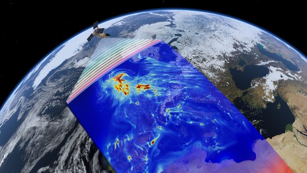
The Copernicus Sentinel-5P satellite has taken its first look at air pollution. Media representatives are invited to DLR on 1 December to see these first tantalising results
Odborný referent – Oddělení obnovy katastrálního operátu 1
21.11.2017 9:49 ČÚZK - předpisy a opatření Katastrální úřad pro Karlovarský krajvypisuje výběrové řízení na místo
Odborný referent – Oddělení obnovy katastrálního operátu 1
Odborný referent – Oddělení obnovy katastrálního operátu 1
21.11.2017 9:49 ČÚZK - volná místa Katastrální úřad pro Karlovarský kraj vypisuje výběrové řízení na místo Odborný referent – Oddělení obnovy katastrálního operátu 1Odborný referent – Oddělení obnovy katastrálního operátu 1
21.11.2017 9:49 ČÚZK /Urady/Katastralni-urady/Katastralni-urady/Katastralni-urad-pro-Karlovarsky-kraj/Uredni-deska/Oznameni-a-jina-uredni-sdeleni/Volna-mista/Odborny-referent-–-Oddeleni-obnovy-katastralniho-oVyšlete svůj návrh do vesmíru s misí Cheops
21.11.2017 8:43 Český Kosmický PortálESA nabízí grafickým designérům a umělcům unikátní příležitost umístit svoji práci na raketu, která do vesmíru vynese družici Cheops.
Vyšlete svůj návrh do vesmíru s misí Cheops
21.11.2017 8:43 Český Kosmický PortálESA nabízí grafickým designérům a umělcům unikátní příležitost umístit svoji práci na raketu, která do vesmíru vynese družici Cheops.
Tradiční konference GIS Ostrava otevřela registraci
21.11.2017 8:39 GISportal.cz Konference GIS Ostrava se tradičně koná v české i anglické jazykové mutaci a tématem letošního ročníku je GIS pro podporu bezpečnosti a krizového řízení, resp. GIS for Safety and Security Management. Letos se v Ostravě můžeme ...Omezení provozu
21.11.2017 8:27 ČÚZK - předpisy a opatření Český úřad zeměměřický a katastrální - Katastrální pracoviště Velké Meziříčí zveřejnil novou aktualitu: Upozorňujeme klienty, že z důvodu poškození kabelu při opravě mostu ve Velkém Meziříčí dochází k velmi častým výpadkům PC sítě společnosti O2. Z toho důvodu je možnost poskytování informací, zakládání řízení a jiných činností, které jsou na síti závislé, velmi omezené.Děkujeme za pochopení