


![]()

zprávy
zdroje zpráv:INSPIRE stahovací služba WFS pro téma Rozšířené Parcely (CPX)
27.10.2017 2:00 Cenia - Katalog metadat ČR - INSPIRE Stahovací služba pro Rozšířené Parcely (CPX) je veřejná stahovací služba pro poskytování dat z Informačního systému katastru nemovitostí (ISKN), umožňující uživatelům opakované stahování těchto dat v souborech po katastrálních územích a online přístup k těmto datům pomocí technologie WFS 2.0.0. Stahovací služba poskytuje harmonizovaná data Rozšířených Parcel (CPX) ve formátu GML vycházející z INSPIRE. Služba je dostupná pro celé území České republiky. Publikovaná data obsahují katastrální území pro celou Českou Republiku, parcely a jejich hranice, věcná břemena, další prvky mapy a původní obloukovou geometrii z území, kde je digitální mapa (k 23. 10. 2017 je to 92,91% území České republiky, t.j. 73 272,25km2) a ve zbytku území katastrální parcely určené pouze definičním bodem (tedy bez hranic a polygonu) jako analogové parcely. Služba splňuje technické pokyny pro INSPIRE stahovací služby verze 3.0.1 a zároveň splňuje standard OGC WFS 2.0.0.INSPIRE téma Parcely (CP)
27.10.2017 2:00 Cenia - Katalog metadat ČR - INSPIRE Data odpovídají směrnici INSPIRE pro téma katastrální parcely (CP). Vychází z katastrální mapy, která je závazným státním mapovým dílem velkého měřítka, obsahuje body polohového bodového pole, polohopis a popis a může mít formu digitální mapy, analogové mapy nebo digitalizované mapy. Data publikovaná v rámci INSPIRE obsahují pouze katastrální území (pro celou Českou Republiku) a parcely a jejich hranice z území, kde je digitální mapa (k 23. 10. 2017 je to 92,91% území České republiky, t.j. 73 272,25km2). Více katastrální zákon 344/1992 SB., katastrální vyhláška č.26/2007 Sb. v platném znění a INSPIRE Data Specification on Cadastral Parcels v 3.0.1. Data ve formátu GML 3.2.1 jsou validní proti schématu XML pro INSPIRE téma Parcely ve verzi 4.0 a proti schématu pro prostorová data ELF ve verzi 1.0.Katastrální mapa ve formátech DGN a DXF poskytovaná v e-shopu
27.10.2017 2:00 Cenia - Katalog metadat ČR - INSPIRE Katastrální mapa je závazným státním mapovým dílem velkého měřítka, obsahuje body polohového bodového pole, polohopis a popis. Katastrální mapa ve vektorové podobě je poskytována zdarma ve formátu DGN a DXF a obsahuje prvky Digitální katastrální mapy (DKM) a Katastrální mapy digitalizované (KMD), tedy bodová pole, budovy, další prvky mapy, hranice parcel, katastrální hranice, parcely katastru nemovitostí, prvky orientační mapy a hranice věcného břemene. Z důvodu použití formátu DGN produkt neobsahuje značky na liniích a oblouky jsou nahrazeny lomenými čárami. Katastrální mapa ve vektorové podobě k 23. 10. 2017 pokrývá 92,91% území České republiky, t.j. 73 272,25km2. Více katastrální vyhláška č.357/2013 Sb. v platném znění.INSPIRE téma Rozšířené Parcely (CPX)
27.10.2017 2:00 Cenia - Katalog metadat ČR - INSPIRE Rozšíření má za cíl poskytovat katastrální mapu s obsahem podle vyhlášky ve vektorové podobě ve struktuře plně v souladu se strukturou danou směrnicí INSPIRE. Data rozšiřují směrnici INSPIRE pro téma katastrální parcely (CP) o věcná břemena, geodetické body, další prvky mapy, původní obloukovou geometrii a o parcely určené definičním bodem (ty pouze v oblastech s analogovou mapou). Vychází z katastrální mapy, která je závazným státním mapovým dílem velkého měřítka, obsahuje body polohového bodového pole, polohopis a popis a může mít formu digitální mapy, analogové mapy nebo digitalizované mapy. Publikovaná data obsahují katastrální území pro celou Českou Republiku, parcely a jejich hranice, věcná břemena, další prvky mapy a původní obloukovou geometrii z území, kde je digitální mapa (k 23. 10. 2017 je to 92,91% území České republiky, t.j. 73 272,25km2) a ve zbytku území katastrální parcely určené pouze definičním bodem (tedy bez hranic a polygonu). Katastrální parcely a hranice obsahují oproti datové sadě INSPIRE některé atributy navíc. Jedná se o typ hranice, způsob využití území, druh pozemku, vazbu na budovu a o mapové značky. Více katastrální zákon 344/1992 SB., katastrální vyhláška č.26/2007 Sb. v platném znění a INSPIRE Data Specification on Cadastral Parcels v 3.0.1. Data ve formátu GML 3.2.1 jsou validní proti schématu XML pro Rozšířené Parcely (CPX) ve verzi 4.0.Katastrální mapa v rastrové podobě poskytovaná v e-shopu
27.10.2017 2:00 Cenia - Katalog metadat ČR - INSPIRE Katastrální mapa v rastrové podobě je poskytována za úplatu a obsahuje analogovou mapu s kompletní kresbou. Analogová mapa pokrývá 5,71 % území České republiky, což je 4 501,46km2. Více katastrální vyhláška č.357/2013 Sb. v platném znění.INSPIRE téma Budovy (BU)
27.10.2017 2:00 Cenia - Katalog metadat ČR - INSPIRE Data odpovídají směrnici INSPIRE pro téma budovy (BU). Data pochází částečně z projektu RÚIAN (Registr územní identifikace, adres a nemovitostí), který je součástí základních registrů České Republiky a obsahuje informace o územní identifikaci, adresách a nemovitostech, a částečně z ISKN (Informační systém katastru nemovistostí). Zdrojem informací o budovách v ISKN je objekt Stavba, v RÚIAN je to Stavební objekt. Většina Staveb je zároveň Stavebními objekty, ale jsou případy, kdy tomu tak není. Kromě Budov datová sada obsahuje i části budov, které jsou pro potřeby INSPIRE vyjádřeny vchody z RÚIAN. Vchody obsahují informace o počtu podlaží, technickoekonomických atributech apod. Datová sada pokrývá celé území české republiky. V datové sadě není uvedeno 1,77%, t.j. 74681 budov (k 23. 10. 2017), protože neobsahují definiční bod ani polygon. Více v zákoně č. 111/2009 Sb., o základních registrech, ve vyhlášce č. 359/2011 Sb., o základním registru územní identifikace, adres a nemovitostí v platných zněních, v zákoně 256/2013 Sb., o katastru nemovitostí, v katastrální vyhlášce č. 357/2013 Sb. v platném znění a INSPIRE Data Specification on Buildings v 3.0 z 13.12.2013. Data ve formátu GML 3.2.1 jsou validní proti schématu XML pro INSPIRE téma Budovy ve verzi 4.0 a proti schématu pro prostorová data ELF ve verzi 1.0.INSPIRE téma Adresy (AD)
27.10.2017 2:00 Cenia - Katalog metadat ČR - INSPIRE Data odpovídají směrnici INSPIRE pro téma adresy (AD). Vychází především z projektu RÚIAN (Registr územní identifikace, adres a nemovitostí), který je součástí základních registrů České Republiky a obsahuje informace o územní identifikaci, adresách a nemovitostech. Data publikovaná v rámci INSPIRE obsahují pouze adresní místa a jejich komponenty, kterými jsou stát, obec, část obce, městský obvod v Praze (MOP), městký obvod/městská část (MO/MČ), ulice a pošta a to na území celé České Republiky. Obsahují rozvněž geometrii, která určuje definiční bod adresního místa. V datové sadě nění uvedeno 1,90%, t.j. 55241 adresních míst (k 23. 10. 2017), protože neobsahují definiční bod, podle kterého by je bylo možné prostorově určit. Více v zákoně č. 111/2009 Sb., o základních registrech a ve vyhlášce č. 359/2011 Sb., o základním registru územní identifikace, adres a nemovitostí v platných zněních a INSPIRE Data Specification on Addresses v 3.0.1 z 26.4.2010. Data ve formátu GML 3.2.1 jsou validní proti schématu XML pro INSPIRE téma Adresy ve verzi 4.0 a proti schématu pro prostorová data ELF ve verzi 1.0.Nízkonákladové hodiny pro přistání na Měsíci
27.10.2017 1:58 Český Kosmický PortálEvropské hodiny s přesností na trilióntinu sekundy se připravují k letu na družicích a lunárních sondách.
Administrativní a spisový pracovník, odbor personální (asistent/ka)
27.10.2017 0:00 Státní pozemkový úřad Státní pozemkový úřad přijme zaměstnance na pozici administrativní a spisový pracovník, odbor personální (asistent/ka).Velodyne LiDAR Partners with YellowScan for Integrated LiDAR for UAVs
26.10.2017 20:10 GISCafe.com Webcasts-Webinars YellowScan to leverage Velodyne’s lightweight VLP-16 Puck LiDARsensors for its advanced aerial Surveyor LiDAR system
SAN …
New Interactive Map Reveals the Colorado Counties With the Most Felony DUI Arrests
26.10.2017 20:10 GISCafe.com Webcasts-Webinars The data shows that Pueblo County, which makes up the 10th Judicial District, currently has the fewest DUI-related court filings per capita for …Airbus DS Communications and Collier County Break New Ground to Improve Location Accuracy
26.10.2017 20:09 GISCafe.com Webcasts-Webinars TEMECULA, CA, Oct. 26, 2017 (GLOBE NEWSWIRE) -- Airbus DS Communications, North America’s leading Public Safety communications provider, and …With New AirMap-FAA Integration, Drone Operators Receive Automated Access to Controlled Airspace
26.10.2017 20:09 GISCafe.com Webcasts-Webinars Automated authorization on the AirMap platform is available to Part 107 operators at four U.S. airports, with more FAA facilities expected in the …Družice Sentinel-1 vidí skrze hurikány
26.10.2017 18:03 Český Kosmický PortálLetošní atlantická hurikánová sezóna je drsnou připomínkou smutku a devastace, které tyto rozsáhlé bouře s sebou přinášejí. Snímkování hurikánů z patřičného nadhledu, z vesmíru, není ničím novým. Ovšem družice rodiny Sentinel-1 mají schopnost vidět přímo skrze tyto rotující meteorologické jevy a třeba měřit výšku hladiny moře. Tím mohou pomoci s předpovídáním budoucího pohybu bouře.
Družice Sentinel-1 vidí skrze hurikány
26.10.2017 18:03 Český Kosmický PortálLetošní atlantická hurikánová sezóna je drsnou připomínkou smutku a devastace, které tyto rozsáhlé bouře s sebou přinášejí. Snímkování hurikánů z patřičného nadhledu, z vesmíru, není ničím novým. Ovšem družice rodiny Sentinel-1 mají schopnost vidět přímo skrze tyto rotující meteorologické jevy a třeba měřit výšku hladiny moře. Tím mohou pomoci s předpovídáním budoucího pohybu bouře.
Dvojnásobný výkon oproti SATA SSD diskům
26.10.2017 15:54 GeoBusiness Společnost ADATA dnes představila SSD disk XPG SX6000. Tento disk přinese do PCI Express disků výkon, známý z M.2 disků, a přitom s cenou tradičních 2,5“ SSD disků SATA. SSD disk SX6000 je k dispozici ve formátu M.2 a dosahuje rychlostí až 1 000 MB/s pro čtení a 800 MB/s pro zápis, což je s […]Dvojnásobný výkon oproti SATA SSD diskům
26.10.2017 15:54 GeoBusiness Společnost ADATA dnes představila SSD disk XPG SX6000. Tento disk přinese do PCI Express disků výkon, známý z M.2 disků, a přitom s cenou tradičních 2,5“ SSD disků SATA. SSD…Pozvánka na konferenci Atlases–Cognition–Usability
26.10.2017 15:40 GISportal.cz Katedra geoinformatiky Univerzity Palackého v Olomouci zve všechny zájemce o kartografii na konferenci „Atlases–Cognition–Usability“, která se uskuteční v dubnu příštího roku v Olomouci. Konference je pořádána ve spolupráci tří komisí Mezinárodní kartografické asociace – Komise atlasové kartografie, Komise ...Dvojnásobný výkon oproti SATA SSD diskům
26.10.2017 13:54 GeoBusiness Společnost ADATA dnes představila SSD disk XPG SX6000. Tento disk přinese do PCI Express disků výkon, známý z M.2 disků, a přitom s cenou ... PřečístDvojnásobný výkon oproti SATA SSD diskům
26.10.2017 13:54 GeoBusiness Společnost ADATA dnes představila SSD disk XPG SX6000. Tento disk přinese do PCI Express disků výkon, známý z M.2 disků, a přitom s cenou ... Read MoreGfK releases updated maps for all of Europe
26.10.2017 11:12 GISCafe.com Webcasts-Webinars GfK’s Europe Map Edition 2017/2018 shows current administrative and postcode boundariesBruchsal, Germany, October 25, 2017 – GfK has …
MISYS 13.21 byl publikován
26.10.2017 10:21 GEPRORádi bychom Vás informovali o zveřejnění verze 13.21 systému MISYS.
Stahovat ji můžete z obvyklého umístění na našem download serveru:
-
MISYS .
Hexagon CFO and EVP to act as CEO During Periods of Ola Rollén's Unavailability due to Court
26.10.2017 9:00 GISCafe.com Webcasts-Webinars NACKA STRAND, Sweden, Oct. 27, 2017 — (PRNewswire) — Ola Rollén, Hexagon President and CEO, will appear in court for his trial which …Hexagon Interim Report 1 January - 30 September 2017
26.10.2017 9:00 GISCafe.com Webcasts-Webinars NACKA STRAND, Sweden, Oct. 27, 2017 — (PRNewswire) — Third quarter 2017Operating net sales increased by 10 per cent to 859.7 …
Video: Esri UC 2017: Shock Trauma Air Rescue Service (STARS)
26.10.2017 9:00 GISCafe.com Webcasts-WebinarsDalší nabídka práce v Hradci Králové
26.10.2017 8:29 GISportal.cz Pokud Vás láká práce ve státní správě, město Hradec Králové hledá GISáka.Urbanistická studie rozvojových zón letiště Brno-Tuřany, Černovická terasa a Šlapanice, 2006
26.10.2017 2:00 Cenia - Katalog metadat ČR - INSPIRE Koordinace rozvoje území rozvojových zón letiště Brno-Tuřany a Šlapanické terasy a navazující rozvojové zóny tzv. Brněnského podnikatelského parku na Černovické terase v Brně.Generel regionálního a nadregionálního ÚSES na území JMK, 2003
26.10.2017 2:00 Cenia - Katalog metadat ČR - INSPIRE Analýza a vymezení nadregionálního a regionálního ÚSES vycházející z platných územně plánovacích dokumentací a z Územně technického podkladu regionálních a nadregionálních ÚSES ČR. Řešení vymezení regionálního a nadregionálního ÚSES novým jednotným vymezením.Rychlostní silnice R43 v úseku Svitávka – hranice JMK, 2001
26.10.2017 2:00 Cenia - Katalog metadat ČR - INSPIRE Prověření průchodnosti rychlostní silnice s označením R43 územím mezi Svitávkou a Velkými Opatovicemi jako propojení paralelně vedených tahů dálnice D1 Praha – Brno a rychlostní silnice R 35 Hradec Králové – Olomouc.Územní studie prověření trasy Boskovické spojky a přeložky silnice II/374, 2007
26.10.2017 2:00 Cenia - Katalog metadat ČR - INSPIRE Zkoordinování záměrů a požadavků v území v katastrálním území obce Lhoty Rapotiny a části katastrálního území Boskovic. Prověření možnost realizace Boskovické spojky s napojením na stávající trať železničního koridoru Česká Třebová - Brno s uvažovaným výhledem zvýšení traťové rychlosti a v souvislosti návrhem přeložky silnice II/374.Urbanistická studie Lednicko-valtický areál, 2005
26.10.2017 2:00 Cenia - Katalog metadat ČR - INSPIRE Posouzení ekologické únosnosti rozvojových záměrů ze schválených ÚPD obcí LVA ve znění doplňků a změn, rozbor krajinného rázu, dopřesnění nadregionálních, regionálních a lokálních prvků ÚSES a posouzení zastavitelnosti území a podmínek pro zástavbu.Studie jihovýchodní tangenty města Brna, 2001
26.10.2017 2:00 Cenia - Katalog metadat ČR - INSPIRE Prověření možnosti vedení Jihovýchodní tangenty v nové trase (Modřice) – D2 – jižně Chrlic – Kobylnice – D1 u Holubic jako komunikace rychlostního charakteru s mimoúrovňovými křižovatkami v parametrech odpovídajících rychlostním silnicím (případně dálnicím), které mohou být realizovány podle aktuálních dopravních potřeb i finančních možností po účelných provozuschopných částech a po polovinách profilu.Vyhledávací studie trasy silnice R43 Boskovickou brázdou v úseku mezi Troubskem a Kuřimí, 2005
26.10.2017 2:00 Cenia - Katalog metadat ČR - INSPIRE Prověření reálnosti vedení trasy rychlostní silnice R43 mezi Troubskem a Kuřimí západně od Brna Boskovickou brázdou pro převedení tranzitu ve dvou variantách.Prověřovací územní studie v oblasti Jihozápadně města Brna, 2008
26.10.2017 2:00 Cenia - Katalog metadat ČR - INSPIRE Prověření potenciálu využití území ve variantách ve vazbě na varianty tras silniční dopravy nadmístního významu, které převádějí tranzitní silniční dopravu v prostoru jižně od dálnice D1 a západně od dálnice D2. Doporučení dopravní varianty, která umožňuje nejvýhodnější rozvoj územního potenciálu všech dotčených obcí a zároveň nejvýhodnější převedení tranzitní silniční dopravy územím jižně od Brna.Územní studie silnice II/380 Sokolnice – Čejč, 2012
26.10.2017 2:00 Cenia - Katalog metadat ČR - INSPIRE tématické vrstvy + rastry výkresůOrbit GT updates 3D Mapping Cloud with great new UAV support at UAV Expo, Las Vegas.
26.10.2017 1:25 GISCafe.com Webcasts-Webinars Lokeren, Belgium, October 25, 2017 -- Orbit GT updates its SaaS product 3D Mapping Cloud with a range of new tools an great UAV …CoreLogic Reports Third Quarter 2017 Financial Results
26.10.2017 0:53 GISCafe.com Webcasts-Webinars —Strong Operating Results Highlighted by Significant RevenueOutperformance of Market Trends and Margin Expansion; Share Repurchase
…
Oznámení o vyhlášení výběrového řízení na služební místo ředitel odboru půdní služby
26.10.2017 0:00 Státní pozemkový úřad Ústřední ředitelka Státního pozemkového úřadu, jako služební orgán příslušný podle § 10 odst. 1 písm. f) zákona č. 234/2014 Sb., o státní službě (dále jen „zákon“), vyhlašuje výběrové řízení na služební místo ředitel odboru půdní služby.Seminář Pozemkové úpravy – zkušenosti s realizacemi v Olešnici na okrese Blansko
26.10.2017 0:00 Státní pozemkový úřadKolik by se s BIM dalo ušetřit na stavebních zakázkách?
25.10.2017 23:36 GeoBusiness Zavádění metody BIM do stavebnictví je strategická záležitost na úrovni státu. Předpokládá se, že metoda BIM (Building Information Management) se stane běžným způsobem realizace zakázek ve stavebnictví, a to jak…Kolik by se s BIM dalo ušetřit na stavebních zakázkách?
25.10.2017 23:36 GeoBusiness Zavádění metody BIM do stavebnictví je strategická záležitost na úrovni státu. Předpokládá se, že metoda BIM (Building Information Management) se stane běžným způsobem realizace zakázek ve stavebnictví, a to jak soukromých i veřejných. Ministerstvo průmyslu a obchodu vydalo v září 2017 54stránkovou publikaci s názvem „Koncepce zavádění metody BIM v České republice“. Obsah publikace Obecně […]Kolik by se s BIM dalo ušetřit na stavebních zakázkách?
25.10.2017 23:36 GeoBusiness Zavádění metody BIM do stavebnictví je strategická záležitost na úrovni státu. Předpokládá se, že metoda BIM (Building Information Management) se stane běžným způsobem realizace ... Read MoreKolik by se s BIM dalo ušetřit na stavebních zakázkách?
25.10.2017 21:36 GeoBusiness Zavádění metody BIM do stavebnictví je strategická záležitost na úrovni státu. Předpokládá se, že metoda BIM (Building Information Management) se stane běžným způsobem realizace ... PřečístBluesky National Tree Map Helps Community Forest Rebuild Environment
25.10.2017 21:30 GISCafe.com Webcasts-Webinars October 25, 2017 -- One of England’s original Community Forest projects is using Bluesky’s National Tree Map to monitor progress and …Dr. Kathryn D. Sullivan to Give Keynote at Esri Ocean GIS Forum
25.10.2017 21:28 GISCafe.com Webcasts-Webinars Attendees Will Learn the Ways Mapping and Analytics Reveal DeeperInsights into Marine Location Data
REDLANDS, Calif. — …
Missouri University of Science and Technology Adds Datumate's Professional Surveying and Mapping Suite to Geoscience Studies
25.10.2017 21:28 GISCafe.com Webcasts-Webinars YOKNEAM, Israel, Oct. 25, 2017 — (PRNewswire) — Missouri University of Science and Technology has chosen Datumate's Site Survey …VectorNav Technologies Receives Accreditation for AS9100/ISO 9001
25.10.2017 19:14 GISCafe.com Webcasts-Webinars DALLAS, Oct. 25, 2017 — (PRNewswire) — VectorNav Technologies, a leading provider of inertial navigation solutions, announces that …Přehledná evidence pachtovních smluv i směn
25.10.2017 16:47Zeptali jsme se projektového manažera aplikace CleverAssets, Oldřicha Kahouna, jaké problémy řeší zemědělci na konci hospodářského roku, když je úroda sklizena a zdánlivě nastává období klidu a odpočinku.
Po sklizni zpravidla dochází ke změnám či vypovězení pachtovních smluv. Má to své důvody. Je zde zohledněn hospodářský cyklus. Málokdo by připustil, aby ztratil nárok hospodařit na půdě v době, kdy má zaseto nebo těsně před sklizní. Půda se tak převádí ve většině případů právě po žních. Pachtovní smlouvy se uzavírají tak, že končí k 30. 9., případně ke konci roku, ale to je méně obvyklé.
Zemědělci by si proto měli zkontrolovat, zda mají všechny pozemky, na kterých hospodaří, pokryté pachtovními smlouvami, případně se snažit dát si je do pořádku.
Může v tomto pomoct aplikace CleverAssets?
Aplikace CleverAssets umožňuje přehledně evidovat pachtovní smlouvy. Jejím největším přínosem je ale navázání na data z katastru nemovitostí. V průběhu smluvního vztahu totiž může nastat mnoho různých situací, které mají vliv na pachtovní smlouvy. A je dobré tyto změny rychle identifikovat a aktivně je řešit. Smluvní vztah tak případně upravit nebo doladit podle toho, o jakou změnu se jedná.
Jaké změny mohou ohrozit zemědělce?
Pokud se jedná o změnu vlastnictví, přechází závazky, tedy i pachtovní smlouvy, na nový subjekt. Hrozí ale, že nový subjekt půdu prodá dál a informace o pachtovní smlouvě se tak někde v procesu vytratí. Původní majitel by měl správně nového vlastníka informovat, že je k pozemku podepsaná pachtovní smlouva a také by mu ji měl předat. K tomu ale mnohdy nedochází.
Nový subjekt může chtít také smlouvu napadnout, aby mohl uzavřít jinou za výhodnějších podmínek. A je pravda, že smlouvy často bývají nedokonalé a může se stát, že na základě právního rozboru je někdo začne rozporovat. Dobrý právník skoro v každé smlouvě najde nějakou skulinku. Znám jeden soudní případ, kdy smlouva byla uzavřena na deset let a byla napadnuta, že k jejímu uzavření došlo za nápadně nevýhodných podmínek.
Může se stát, že zemědělec ztratí právo na parcele hospodařit?
Vzhledem k tomu, že každé zemědělské družstvo chce hospodařit na co největším kusu půdy, stává se, že se snaží vyžádat si svůj nárok na půdu u jiného družstva. Pokud druhé družstvo shledá, že na půdě skutečně nemá právo hospodařit, zpravidla nabídne jako kompenzaci vydání jiného pozemku na okraji svého bloku. Může se ale stát, že ke stejné parcele doloží v průběhu času více družstev pachtovní smlouvu. Pro špatnou evidenci tak za jednu parcelu vydá zemědělské družstvo více kompenzací. Takových dílčích směn učiní několik a vznikne tak celá pavučina vztahů, ve které se jen těžce orientuje.
Často se tak stává, že mají zemědělci nasmlouvané více půdy, než na které skutečně hospodaří. Aplikace CleverAssets umožňuje evidovat tyto směny přehledně a jednoduše. Na jednom místě jde vidět, kterou parcelu jsme vyměnili za kterou, což eliminuje situace, kdy bychom za jednu parcelu vydali dvě jiné. Uživatel tak může snáze pavučinu vztahů popsat a rozplést. Pokud už došlo k vydání některé parcely, aplikace na to uživatele upozorní. A mapové okno uživateli přehledně zobrazí, na kterých pozemcích dochází k nesrovnalostem.
Proč tedy nemá družstvo podepsané pachtovní smlouvy právě na pozemky, na kterých hospodaří?
Běžný vlastník má parcely různě rozházené po katastru. Pokud se rozhodne, že je pronajme, nebude pronajímat každou zvlášť. Pronajme všechny dohromady, včetně těch méně zajímavých. Nikdo nechce řešit každou parcelu zvlášť, jde o nájmy v řádech tisíci korun, tak to chce mít každý co nejjednodušší.
A není hospodaření na pozemku, ke kterému má uzavřenou pachtovní smlouvu jiný subjekt, v rozporu s touto smlouvou?
To je jeden z rozdílů mezi nájemní a pachtovní smlouvou. Dřív, když se k polím podepisovala nájemní smlouva, měl zemědělec možnost půdu dále pronajímat. S novým občanským zákoníkem tato možnost pominula a ve smlouvě to musí být výslovně uvedeno. Není-li uvedeno, je to zakázáno. Přesto k tomu dochází, jinak to nejde.
Jak tedy vyberu vhodný pozemek, který směním?
Někteří zemědělci řeší směnu za výměru, jiní spíše za bonitu. Aplikace CleverAssets umí v tuto chvíli pracovat pouze s výměrou. V budoucnu by ale mohla sloužit jako garantovaný podklad pro jednání o směně pozemků. Chtěli bychom do aplikace zakomponovat funkci, která by uměla vyhodnocovat nějaké vstupní parametry a na základě nich by doporučovala pozemky, které je vhodné vydat.
Zdá se, že správa majetku není zdaleka tak jednoduchá věc, jak by se mohlo zdát.
Evidence pachtovních smluv a směn práva k hospodaření je poměrně složitá záležitost a personálně je tato agenda na farmách podhodnocená. Výrazným způsobem však může pomoci právě aplikace CleverAssets, která umí upozorňovat na rizika spojená s touto problematikou.
Jaké další úkony jsou se správou majetku spojené?
Na konci hospodářského roku je ještě potřeba vyplatit pachtovné. Standardně má zemědělské družstvo určený jeden termín, ke kterému pachty vyplácí, nejčastěji se jedná o 31. prosinec. V praxi to ale funguje tak, že se pachtovné začne vyplácet už po žních. A ačkoli se vyplácí jen jednou ročně, i tak je to časově poměrně náročné.
Pomocí CleverAssets mohou ale uživatelé vyplácet pachtovné jednoduše. Aplikace nachystá vše potřebné. Pokud má tedy uživatel vše v pořádku, může být vyplacení pachtovného operace, která trvá řádově pár minut. Automaticky vygeneruje hromadný příkaz k úhradě pro banku nebo hromadný soubor pro vygenerování složenek.
A co určuje cenu pachtovného?
Výši pachtovného určuje v současné době trh. Dříve tomu ale tak nebylo. V 90. letech, když dostali lidé půdu v restituci, měli strach, že půda zůstane ležet ladem. Dnes se pachtýř snaží motivovat propachtovatele, aby půdu pronajal právě jemu.
Vysledovali jsme, že z psychologického hlediska velmi dobře působí, když pachtýř nabídne propachtovateli něco navíc, a tím je příspěvek na úhradu daně. Ve smlouvě jsou tedy uvedeny dvě částky, pachtovné spočítané dle výměry pozemku a ceny za hektar a právě zmíněný příspěvek na úhradu daně, jehož výši lze spočítat z veřejně dostupných dat.
Jak je to s pachtovným v okamžiku, kdy dojde v průběhu roku ke změně vlastníka?
Pokud se v průběhu roku změní vlastník pozemku, stávalo se, že se vyplatilo celé pachtovné novému vlastníkovi. V aplikaci CleverAssets je to ale vyřešené tak, že vyplatíme pachtovné oběma subjektům v poměru, který odpovídá částem roku, po kterou půdu vlastnili.
A k otázce daně se dá přistupovat dvojím způsobem. Z pohledu právního pachtýř platí pouze pachtovné, a proto by měla být celá částka rozdělena poměrovým číslem. Ale dle logiky věci by původní vlastník měl dostat celou náhradu za daň, kterou uhradil. Ze zbylé částky by pak dostal už jen poměrnou část. A nový vlastník dostane jen svou poměrnou část.
Pozn. Termín pachtovní smlouva se znovu objevil s novým občanským zákoníkem, aby se odlišil od nájmu. Právní rozdíl je ten, že v případě pachtu smí pachtýř užívat nejen nemovitost, ale i užitek, který z jejího užívání plyne. Zatímco nájem je typicky u bytů, které nájemníci jen využívají. Z pachtovních smluv k pozemkům plyne také právo sklízet plodiny, které lze na poli vypěstovat a sklidit.
Jiné významné odlišnosti pachtovní smlouvy nemají. Stejně jako smlouvy nájemní se uzavírají na dobu určitou i neurčitou. Ale pokud jsou na dobu určitou, uzavírají se většinou na delší období. V zemědělství je nesmysl uzavřít smlouvu na období kratší než rok.
Ve smlouvě musí být uvedeno kdo s kým ji uzavírá a na jak dlouhou dobu. A pak musí být uvedena specifikace nemovitostí, které jsou obsahem smlouvy.
20172510 - Uzamčení volebních okrsků v ISÚI
25.10.2017 15:11 ČÚZK /Uvod/Produkty-a-sluzby/RUIAN/Volebni-okrsky-v-RUIAN/Archiv-novinky/20172510-Uzamceni-volebnich-okrsku-v-ISUI20172510 - Uzamčení volebních okrsků v ISÚI
25.10.2017 15:11 ČÚZK - předpisy a opatření Rozhodnutím předsedy senátu PČR ze dne 23. 8. 2017 byly vyhlášeny volby prezidenta republiky (dny konání: 12. a 13. ledna 2018), což bylo zveřejněno ve Sbírce zákonů dne 28. 8. 2017. Od vyhlášení voleb do vyhlášení celkových výsledků voleb Státní volební komisí jsou uzamčeny volební okrsky, a proto nyní nelze měnit vymezení volebních okrsků v RÚIAN.20171025 - Uzamčení volebních okrsků v ISÚI
25.10.2017 15:03 ČÚZK /Uvod/Produkty-a-sluzby/RUIAN/RUIAN-novinky/2017/20171025-Uzamceni-volebnich-okrsku-v-ISUI20171025 - Uzamčení volebních okrsků v ISÚI
25.10.2017 15:03 ČÚZK - předpisy a opatření Rozhodnutím předsedy senátu PČR ze dne 23. 8. 2017 byly vyhlášeny volby prezidenta republiky 2017 (dny konání: 12. a 13. ledna 2018), což bylo zveřejněno ve Sbírce zákonů dne 28. 8. 2017. Od vyhlášení voleb do vyhlášení celkových výsledků voleb Státní volební komisí jsou uzamčeny volební okrsky, a proto nyní nelze měnit vymezení volebních okrsků v RÚIAN.Zveřejněno 25. 10. 2017
DataCapable connects with MultiSpeak® community in supporting the real-time sharing of outage reports with existing utility systems
25.10.2017 14:27 GISCafe.com Webcasts-Webinars October 25, 2017 - DataCapable Inc. is excited to announce our membership within the MultiSpeak® community of operations standards in …IDS GeoRadar unveils ground penetrating radar to improve safety before cutting or drilling into concrete structures
25.10.2017 13:49 GISCafe.com Webcasts-Webinars C-thrue is an all-in-one, robust solution to see through concrete structures and reveal true data(Pisa, Italy, 24 October 2017) – IDS …
GNSS raw measurements set to be a game changer
25.10.2017 13:47 European GNSS Agency.")
Are GNSS raw measurements in consumer devices just a playground for scientists, or do they represent a real market opportunity? This was the question posed by the GSA’s Raw Measurements Task Force at a panel discussion on the topic held 28 September at ION GNSS+ in Portland, Oregon (USA).
With a smartphone featuring Android 7.0 (i.e., Nougat), users now have access to raw GNSS measurements – opening the door to higher-accuracy and the development of algorithms once restricted to more advanced GNSS receivers. This new capability also allows users to fully benefit from the special features offered by Galileo and to efficiently combine these features with other constellations.
According to Google’s Frank van Diggelen, the first beneficiaries are the phone manufacturers: using the raw measurements with analysis tools provided by Google, the manufacturers can analyse GNSS performance in new phone designs. “GNSS raw measurements also create new opportunities for developers and users,” he said during his opening remarks. “The challenge is to innovate using raw measurements and not simply repeating position velocity and time calculation already done at the GNSS chip.” Along this line, he noted that Google is set to rollout a range of new tools with the specific purpose of using raw measurements for easier and more powerful data analysis.
Raw Measurements Task Force takes the reins
Although the availability of raw measurements was eagerly anticipated by the GNSS community, their use has remained limited to testing by GNSS experts. To help get a better understanding of this feature’s true potential and to promote its use to application developers, the GSA established the Raw Measurements Task Force.
“The purpose of the task force is to explore the real business opportunities of having access to GNSS raw measurements,” said NSL General Manager and Task Force member Mark Dumville. “It is open to all interested parties who share our goal of supporting both the GNSS and developer communities in using raw measurements for innovative commercial and societal applications.”
The Task Force is currently working on a White Paper explaining how GNSS raw measurements can be used to optimise the calculation of position, how they can be best corrected, and how they can create opportunities for innovative applications.
“It is our intent that this White Paper will be the de facto international reference for accessing and using raw measurements,” added Dumville. “The paper’s contents will include information on how to use the measurements, best practices, case studies and early examples of applications benefiting from processing raw measurements on Android devices.”
The White Paper, which is currently in draft form, will also provide an outlook on the future use of raw measurements.
Successful testing
In addition to its theoretical work, the Task Force is also busy performing tests on the mobile hardware that is already enabled for processing raw measurements. The purpose of these tests is to assess both current and future performance of the raw measurements. “Initial results are encouraging, as performance in optimal environments can achieve metre-level accuracy using different techniques,” explained the University of Nottingham’s Lukasz Bonenberg, who is also a Task Force member.
According to Bonenberg, realistic scenario testing has identified two key limitations: linearly polarised antenna and duty cycles on GNSS chipsets, both of which limit the use of carrier phase observations – a requirement for achieving sub-metre accuracy. However, he assured the panel that solutions are possible. Bonenberg also confirmed that those devices capable of using raw measurements should be able to take advantage of the additional layer of integrity and robustness that the measurements provide.
That being said, Bonenberg doesn’t see positioning enhancement as being the most important raw measurement application. “An extra layer of security, jamming detection or crowdsourcing are just some of the out-of-the-box solutions that are now possible thanks to raw measurements,” he said. “Developers should not try to beat chipset manufacturers at accuracy, but instead focus on using existing knowledge to introduce new and more flexible solutions and services.”
Opportunity for Galileo
To demonstrate the role of Galileo within the use of GNSS raw measurements, Astrium’s Moises Navarro pointed to a recent experiment involving two PVT solutions. Although both solutions were based on raw measurements coming from a smartphone, only one included Galileo measurements. “Thanks to the raw measurements, users can select which constellations the PVT uses and which satellites are filtered out,” he explained to the panel. “However, by opting to include Galileo in the PVT solution through the raw measurements, users can easily experience the added accuracy and availability it provides.”
Moises also explained how raw measurements enables other GNSS differentiators. “For example, Galileo’s Open Service Authentication is a unique feature not found in other GNSS constellations,” he added. “Since this navigation message is included in raw measurements, developers can use this feature to authenticate navigation messages.”
Playground or Market Opportunity?
“Clearly, raw measurements have the potential to unlock new GNSS innovations,” concluded GSA Deputy Head of Market Development Fiammetta Diani, who moderated the workshop. “More so, Galileo has much to offer, including the E5 second frequency and the Open Service Authentication – both of which will be game-changers for autonomous applications and location-based applications.”
So, the question remains: are raw measurements simply a playground for scientists or do they in fact represent a real market opportunity? According to those at the ION GNSS+ panel discussion, there isn’t any doubt that the answer is clearly the latter.
Media note: This feature can be republished without charge provided the European GNSS Agency (GSA) is acknowledged as the source at the top or the bottom of the story. You must request permission before you use any of the photographs on the site. If you republish, we would be grateful if you could link back to the GSA website (http://www.gsa.europa.eu).
GNSS raw measurements set to be a game changer
25.10.2017 13:47 European GNSS Agency
Are GNSS raw measurements in consumer devices just a playground for scientists, or do they represent a real market opportunity? This was the question posed by the GSA’s Raw Measurements Task Force at a panel discussion on the topic held 28 September at ION GNSS+ in Portland, Oregon (USA).
With a smartphone featuring Android 7.0 (i.e., Nougat), users now have access to raw GNSS measurements – opening the door to higher-accuracy and the development of algorithms once restricted to more advanced GNSS receivers. This new capability also allows users to fully benefit from the special features offered by Galileo and to efficiently combine these features with other constellations.
According to Google’s Frank van Diggelen, the first beneficiaries are the phone manufacturers: using the raw measurements with analysis tools provided by Google, the manufacturers can analyse GNSS performance in new phone designs. “GNSS raw measurements also create new opportunities for developers and users,” he said during his opening remarks. “The challenge is to innovate using raw measurements and not simply repeating position velocity and time calculation already done at the GNSS chip.” Along this line, he noted that Google is set to rollout a range of new tools with the specific purpose of using raw measurements for easier and more powerful data analysis.
Raw Measurements Task Force takes the reins
Although the availability of raw measurements was eagerly anticipated by the GNSS community, their use has remained limited to testing by GNSS experts. To help get a better understanding of this feature’s true potential and to promote its use to application developers, the GSA established the Raw Measurements Task Force.
“The purpose of the task force is to explore the real business opportunities of having access to GNSS raw measurements,” said NSL General Manager and Task Force member Mark Dumville. “It is open to all interested parties who share our goal of supporting both the GNSS and developer communities in using raw measurements for innovative commercial and societal applications.”
The Task Force is currently working on a White Paper explaining how GNSS raw measurements can be used to optimise the calculation of position, how they can be best corrected, and how they can create opportunities for innovative applications.
“It is our intent that this White Paper will be the de facto international reference for accessing and using raw measurements,” added Dumville. “The paper’s contents will include information on how to use the measurements, best practices, case studies and early examples of applications benefiting from processing raw measurements on Android devices.”
The White Paper, which is currently in draft form, will also provide an outlook on the future use of raw measurements.
Successful testing
In addition to its theoretical work, the Task Force is also busy performing tests on the mobile hardware that is already enabled for processing raw measurements. The purpose of these tests is to assess both current and future performance of the raw measurements. “Initial results are encouraging, as performance in optimal environments can achieve metre-level accuracy using different techniques,” explained the University of Nottingham’s Lukasz Bonenberg, who is also a Task Force member.
According to Bonenberg, realistic scenario testing has identified two key limitations: linearly polarised antenna and duty cycles on GNSS chipsets, both of which limit the use of carrier phase observations – a requirement for achieving sub-metre accuracy. However, he assured the panel that solutions are possible. Bonenberg also confirmed that those devices capable of using raw measurements should be able to take advantage of the additional layer of integrity and robustness that the measurements provide.
That being said, Bonenberg doesn’t see positioning enhancement as being the most important raw measurement application. “An extra layer of security, jamming detection or crowdsourcing are just some of the out-of-the-box solutions that are now possible thanks to raw measurements,” he said. “Developers should not try to beat chipset manufacturers at accuracy, but instead focus on using existing knowledge to introduce new and more flexible solutions and services.”
Opportunity for Galileo
To demonstrate the role of Galileo within the use of GNSS raw measurements, Astrium’s Moises Navarro pointed to a recent experiment involving two PVT solutions. Although both solutions were based on raw measurements coming from a smartphone, only one included Galileo measurements. “Thanks to the raw measurements, users can select which constellations the PVT uses and which satellites are filtered out,” he explained to the panel. “However, by opting to include Galileo in the PVT solution through the raw measurements, users can easily experience the added accuracy and availability it provides.”
Moises also explained how raw measurements enables other GNSS differentiators. “For example, Galileo’s Open Service Authentication is a unique feature not found in other GNSS constellations,” he added. “Since this navigation message is included in raw measurements, developers can use this feature to authenticate navigation messages.”
Playground or Market Opportunity?
“Clearly, raw measurements have the potential to unlock new GNSS innovations,” concluded GSA Deputy Head of Market Development Fiammetta Diani, who moderated the workshop. “More so, Galileo has much to offer, including the E5 second frequency and the Open Service Authentication – both of which will be game-changers for autonomous applications and location-based applications.”
So, the question remains: are raw measurements simply a playground for scientists or do they in fact represent a real market opportunity? According to those at the ION GNSS+ panel discussion, there isn’t any doubt that the answer is clearly the latter.
Media note: This feature can be republished without charge provided the European GNSS Agency (GSA) is acknowledged as the source at the top or the bottom of the story. You must request permission before you use any of the photographs on the site. If you republish, we would be grateful if you could link back to the GSA website (http://www.gsa.europa.eu).
GNSS raw measurements set to be a game changer
25.10.2017 13:47 European GNSS AgencyAre GNSS raw measurements in consumer devices just a playground for scientists, or do they represent a real market opportunity? This was the question posed by the GSA’s Raw Measurements Task Force at a panel discussion on the topic held 28 September at ION GNSS+ in Portland, Oregon (USA).
With a smartphone featuring Android 7.0 (i.e., Nougat), users now have access to raw GNSS measurements – opening the door to higher-accuracy and the development of algorithms once restricted to more advanced GNSS receivers. This new capability also allows users to fully benefit from the special features offered by Galileo and to efficiently combine these features with other constellations.
According to Google’s Frank van Diggelen, the first beneficiaries are the phone manufacturers: using the raw measurements with analysis tools provided by Google, the manufacturers can analyse GNSS performance in new phone designs. “GNSS raw measurements also create new opportunities for developers and users,” he said during his opening remarks. “The challenge is to innovate using raw measurements and not simply repeating position velocity and time calculation already done at the GNSS chip.” Along this line, he noted that Google is set to rollout a range of new tools with the specific purpose of using raw measurements for easier and more powerful data analysis.
Raw Measurements Task Force takes the reins
Although the availability of raw measurements was eagerly anticipated by the GNSS community, their use has remained limited to testing by GNSS experts. To help get a better understanding of this feature’s true potential and to promote its use to application developers, the GSA established the Raw Measurements Task Force.
“The purpose of the task force is to explore the real business opportunities of having access to GNSS raw measurements,” said NSL General Manager and Task Force member Mark Dumville. “It is open to all interested parties who share our goal of supporting both the GNSS and developer communities in using raw measurements for innovative commercial and societal applications.”
The Task Force is currently working on a White Paper explaining how GNSS raw measurements can be used to optimise the calculation of position, how they can be best corrected, and how they can create opportunities for innovative applications.
“It is our intent that this White Paper will be the de facto international reference for accessing and using raw measurements,” added Dumville. “The paper’s contents will include information on how to use the measurements, best practices, case studies and early examples of applications benefiting from processing raw measurements on Android devices.”
The White Paper, which is currently in draft form, will also provide an outlook on the future use of raw measurements.
Successful testing
In addition to its theoretical work, the Task Force is also busy performing tests on the mobile hardware that is already enabled for processing raw measurements. The purpose of these tests is to assess both current and future performance of the raw measurements. “Initial results are encouraging, as performance in optimal environments can achieve metre-level accuracy using different techniques,” explained the University of Nottingham’s Lukasz Bonenberg, who is also a Task Force member.
According to Bonenberg, realistic scenario testing has identified two key limitations: linearly polarised antenna and duty cycles on GNSS chipsets, both of which limit the use of carrier phase observations – a requirement for achieving sub-metre accuracy. However, he assured the panel that solutions are possible. Bonenberg also confirmed that those devices capable of using raw measurements should be able to take advantage of the additional layer of integrity and robustness that the measurements provide.
That being said, Bonenberg doesn’t see positioning enhancement as being the most important raw measurement application. “An extra layer of security, jamming detection or crowdsourcing are just some of the out-of-the-box solutions that are now possible thanks to raw measurements,” he said. “Developers should not try to beat chipset manufacturers at accuracy, but instead focus on using existing knowledge to introduce new and more flexible solutions and services.”
Opportunity for Galileo
To demonstrate the role of Galileo within the use of GNSS raw measurements, Astrium’s Moises Navarro pointed to a recent experiment involving two PVT solutions. Although both solutions were based on raw measurements coming from a smartphone, only one included Galileo measurements. “Thanks to the raw measurements, users can select which constellations the PVT uses and which satellites are filtered out,” he explained to the panel. “However, by opting to include Galileo in the PVT solution through the raw measurements, users can easily experience the added accuracy and availability it provides.”
Moises also explained how raw measurements enables other GNSS differentiators. “For example, Galileo’s Open Service Authentication is a unique feature not found in other GNSS constellations,” he added. “Since this navigation message is included in raw measurements, developers can use this feature to authenticate navigation messages.”
Playground or Market Opportunity?
“Clearly, raw measurements have the potential to unlock new GNSS innovations,” concluded GSA Deputy Head of Market Development Fiammetta Diani, who moderated the workshop. “More so, Galileo has much to offer, including the E5 second frequency and the Open Service Authentication – both of which will be game-changers for autonomous applications and location-based applications.”
So, the question remains: are raw measurements simply a playground for scientists or do they in fact represent a real market opportunity? According to those at the ION GNSS+ panel discussion, there isn’t any doubt that the answer is clearly the latter.
Media note: This feature can be republished without charge provided the European GNSS Agency (GSA) is acknowledged as the source at the top or the bottom of the story. You must request permission before you use any of the photographs on the site. If you republish, we would be grateful if you could link back to the GSA website (http://www.gsa.europa.eu).
Mapová aplikace Územně plánovací dokumentace ve Středočeském kraji
25.10.2017 13:00 Středočeský kraj Do mapové aplikace Územně plánovací dokumentace ve Středočeském kraji, v nástroji Sdílení, byl pro tuto konkrétní aplikaci vložen banner ke stažení.Zároveň do mapové aplikace Územně plánovací dokumentace ve Středočeském kraji (dále jen ÚPD) do nástroje Informace, záložka Reporty byl přidán nový report Nová data (stav ke dni 24.10.2017). Od poslední aktualizace přibylo 09 ÚPD.
Natáčeli jsme stavbu stožárů VVN vrtulníkem v špatně přístupném terénu
25.10.2017 12:01 UpVision Natáčeli jsme opět stavbu stožárů VVN tentokrát za pomoci vrtulníku v špatně přístupném terénu.Zajímavé fotky zde:
https://plus.google.com/u/0/b/115833877689730865211/+UpvisionCz1/posts/dE2DHHkYkiJ
Ve všech mapových službách byl
25.10.2017 12:00 Plzeňský kraj Ve všech mapových službách byla provedena aktualizace vektorových katastrálních map (DKM, KMD, KM-D a ÚKM). Data jsou s platností k 1. 10. 2017. Stav digitalizace je k dispozici zde (http://cuzk.cz/Dokument.aspx?AKCE=META:SESTAVA:MDR004_XSLT:WEBCUZK_KRAJ:400). Pro práci s daty katastru nemovitostí je možné například využít tuto mapovou službu (http://mapy.kr-plzensky.cz/gis/katastr/). Seznam všech mapových služeb je k dispozici zde (http://geoportal.plzensky-kraj.cz/gs/vsechny-mapy/).V mapové službě Letecké snímky
25.10.2017 12:00 Plzeňský kraj V mapové službě Letecké snímky vybraných obcí 2014/2015 v rozlišení 5 cm jsou nově doplněni letecké snímky obcí: Bezdružice, Kokašice, Konstantinovy Lázně, Manětín, Nečtiny a Žihle pořízené během roku 2015 v rozlišení 5cm/px. Snímky jsou pořizovány v rámci projektu Digitální technická mapa Plzeňského kraje a jsou pořizovány a poskytovány společností GEOREAL spol. s r.o..V datech územně analytických p
25.10.2017 12:00 Plzeňský kraj V datech územně analytických podkladů Plzeňského kraje byla provedena aktualizace dat technické infrastruktury od poskytovatele ČEZ Distribuce, a. s. (http://geoportal.plzensky-kraj.cz/gs/rss?url=http%3A%2F%2Fgeoportal.plzensky-kraj.cz%2Ftw%2Fost%2Fgp%2Fuap%2Fposkytovatele%2Findex.php%3Fframe%26ID%3D19) a ČEZ ICT Services, a. s. (http://geoportal.plzensky-kraj.cz/gs/rss?url=http%3A%2F%2Fgeoportal.plzensky-kraj.cz%2Ftw%2Fost%2Fgp%2Fuap%2Fposkytovatele%2Findex.php%3Fframe%26ID%3D75) Data jsou s platností k 1. 10. 2017.V mapové službě Letecké snímky
25.10.2017 12:00 Plzeňský kraj V mapové službě Letecké snímky vybraných obcí 2014/2015 v rozlišení 5 cm (http://mapy.kr-plzensky.cz/gis/ortofoto2013) jsou nově doplněni letecké snímky obcí: Bezdružice, Kokašice, Konstantinovy Lázně, Manětín, Nečtiny a Žihle pořízené během roku 2015 v rozlišení 5cm/px. Snímky jsou pořizovány v rámci projektu Digitální technická mapa Plzeňského kraje (http://geoportal.plzensky-kraj.cz/gs/digitalni-technicka-mapa/) a jsou pořizovány a poskytovány společností GEOREAL spol. s r.o. (http://www.georeal.cz/).Ve všech mapových službách byl
25.10.2017 12:00 Plzeňský kraj Ve všech mapových službách byla provedena aktualizace vektorových katastrálních map (DKM, KMD, KM-D a ÚKM). Data jsou s platností k 1. 10. 2017. Stav digitalizace je k dispozici zde. Pro práci s daty katastru nemovitostí je možné například využít tuto mapovou službu. Seznam všech mapových služeb je k dispozici zde.V datech územně analytických p
25.10.2017 12:00 Plzeňský kraj V datech územně analytických podkladů Plzeňského kraje byla provedena aktualizace dat technické infrastruktury od poskytovatele ČEZ Distribuce, a. s. a ČEZ ICT Services, a. s. Data jsou s platností k 1. 10. 2017.Rekonstrukce vchodu do budovy Katastrálního pracoviště Česká Lípa
25.10.2017 10:18 ČÚZK /Urady/Katastralni-urady/Katastralni-urady/Katastralni-urad-pro-Liberecky-kraj/Katastralni-pracoviste/KP-Ceska-Lipa/O-uradu/Aktuality/Rekonstrukce-vchodu-do-budovy-Katastralniho-pracovRekonstrukce vchodu do budovy Katastrálního pracoviště Česká Lípa
25.10.2017 10:18 ČÚZK - předpisy a opatření Katastrální úřad pro Liberecký kraj - Katastrální pracoviště Česká Lípa zveřejnil novou aktualitu: Vážení klienti,ode dne 27. 10. 2017 bude probíhat rekonstrukce vchodu do budovy Katastrálního pracoviště Česká Lípa (na adrese Střelnice 2956, Česká Lípa), spočívající v demontáži a likvidaci stávajících konstrukcí vstupního prostoru a dodávce a montáži nových konstrukcí vstupního prostoru.
V uvedené souvislosti vás upozorňujeme, že práce budou probíhat i ve dnech pracovního volna a klidu (tj. 28. – 29. 10. 2017 a případně též ve dnech 4. – 5. 11. 2017), a to i ve večerních, případně nočních hodinách, za podmínky dodržení nočního klidu (10.00 – 6.00 hodin).
Za případná omezení a komplikace se vám tímto předem omlouváme a děkujeme za pochopení.
Rekonstrukce vchodu do budovy Katastrálního pracoviště Česká Lípa
25.10.2017 10:18 ČÚZK - předpisy a opatření Katastrální úřad pro Liberecký kraj - Katastrální pracoviště Česká Lípa zveřejnil novou aktualitu: Vážení klienti,ode dne 27. 10. 2017 bude probíhat rekonstrukce vchodu do budovy Katastrálního pracoviště Česká Lípa (na adrese Střelnice 2956, Česká Lípa), spočívající v demontáži a likvidaci stávajících konstrukcí vstupního prostoru a dodávce a montáži nových konstrukcí vstupního prostoru.
V uvedené souvislosti vás upozorňujeme, že práce budou probíhat i ve dnech pracovního volna a klidu (tj. 28. – 29. 10. 2017 a případně též ve dnech 4. – 5. 11. 2017), a to i ve večerních, případně nočních hodinách, za podmínky dodržení nočního klidu (22.00 – 6.00 hodin).
Za případná omezení a komplikace se vám tímto předem omlouváme a děkujeme za pochopení.
Mapová aplikace Staré ekologické zátěže
25.10.2017 10:00 Středočeský kraj Byla spuštěna mapová aplikace Staré ekologické zátěže v novém webovém prostředí (Web AppBuilder for ArcGIS, více ZDE). Předmětem mapové aplikace je prezentace aktuálních rizik či potencionálních rizik starých ekologických zátěží, jejímž zdrojem je Inventarizační studie Staré ekologické zátěže Středočeského kraje z roku 2006. Aplikace nahrazuje stávající flexovou mapovou aplikaci, která je veřejnosti k dispozici od roku 2016. Obsah geografických dat zůstává zachován. Přínosem aplikace je především její zobrazení v mobilních zařízeních, dostupnost ve všech webových prohlížečích a rychlejší načítání dat. Aplikace zároveň přináší nové nástroje. Kromě propojení s Google Street View aplikace umožňuje přidávat mapové služby, tj. další služby úřadu nebo služby jiných poskytovatelů. V aplikaci lze jednodušeji vyhledávat podle vybraných vrstev a dle územních jednotek (obce, katastrální území, parcely). V aplikaci lze prohlížet i archivní letecké snímky a vybrané vrstvy Katastru nemovitostí vč. možnosti nahlédnout do Katastru nemovitostí online. V aplikaci lze kreslit vlastní poznámky, které lze exportovat k dalšímu zpracování. Aplikace umožňuje vkládat i vlastní data prostřednictvím formátů, např. SHP. V neposlední řadě aplikace nabízí zjednodušenou identifikaci prvků a možnost aplikaci sdílet. Součástí aplikace je také Nápověda, která je průběžně doplňována videonávody.Sentinel-1 sees through hurricanes
25.10.2017 9:25 ESA Observing the Earth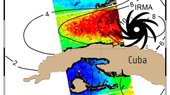
This year’s Atlantic hurricane season has been a harsh reminder of the grief and devastation brought by these vast storms. Imaging the top of hurricanes from space is nothing new, but the Sentinel-1 satellites can see right through these towering spinning weather systems, measuring the sea surface below to help predict the storm’s path.
Reportáž z konference Geomatika v Projektech
25.10.2017 7:39 GISportal.cz Ve dnech 5. a 6. října 2017 proběhl na zámku Kozel u Plzně letošní ročník konference Geomatika v projektech (již 10. ročník), v tomto roce opět spojený s konferencí Informačních systémů v zemědělství a lesnictví ...Reportáž z konference Geomatika v Projektech
25.10.2017 7:39 GISportal.cz Ve dnech 5. a 6. října 2017 proběhl na zámku Kozel u Plzně letošní ročník konference Geomatika v projektech (již 10. ročník), v tomto roce opět spojený s konferencí Informačních systémů v zemědělství a lesnictví ...rada/odborný rada - rozhodování o povolení vkladu
25.10.2017 7:12 ČÚZK /Urady/Katastralni-urady/Katastralni-urady/Katastralni-urad-pro-Olomoucky-kraj/Uredni-deska/Oznameni-a-jina-uredni-sdeleni/Volna-mista/rada-odborny-rada-rozhodovani-o-povoleni-vkladurada/odborný rada - rozhodování o povolení vkladu
25.10.2017 7:12 ČÚZK - volná místa Katastrální úřad pro Olomoucký kraj - Katastrální pracoviště Prostějov vypisuje výběrové řízení na místo rada/odborný rada - rozhodování o povolení vkladurada/odborný rada - rozhodování o povolení vkladu
25.10.2017 7:12 ČÚZK - předpisy a opatření Katastrální úřad pro Olomoucký kraj - Katastrální pracoviště Prostějovvypisuje výběrové řízení na místo
rada/odborný rada - rozhodování o povolení vkladu
OGC announces a new standard that improves the way information is referenced to the earth
25.10.2017 4:14 GISCafe.com Webcasts-Webinars October 24, 2017 -- The membership of the Open Geospatial Consortium (OGC®) has approved the Discrete Global Grid System (DGGS) as OGC …Native American Tribes Share Their Perspectives on GIS in New Esri Book
25.10.2017 4:07 GISCafe.com Webcasts-Webinars Redlands, California—October 24, 2017—A new book from Esri tells the stories of how Native American tribes use geographic information …Územní studie silnice R43 v úseku Svitávka – Sudice, 2014
25.10.2017 2:00 Cenia - Katalog metadat ČR - INSPIRE Vyhledání a návrh trasy silnice R43 v úseku Svitávka – Chrudichromy – Sudice ve variantním řešení vůči trase této silnice navržené v „Technické studii silnice R43 Svitávka – hranice kraje, autor HBH Projekt, 2005 a vymezení koridorů pro ochranu území pro nově navržené trasy do Zásad územního rozvoje Jihomoravského kraje.Zásady územního rozvoje Jihomoravského kraje, výkresy A1-A5
25.10.2017 2:00 Cenia - Katalog metadat ČR - INSPIRE Zásady územního rozvoje Jihomoravského kraje - A1-A5 výkresy Vyhodnocení vlivů JMK na udržitelný rozvoj územíRasterizované územní plány Jihomoravského kraje (2005, 2006)
25.10.2017 2:00 Cenia - Katalog metadat ČR - INSPIRE Vybrané územní plány Jihomoravského kraje digitalizované v letech 2005 a 2006Územní studie aglomeračních vazeb města Brna a jeho okolí, 2010
25.10.2017 2:00 Cenia - Katalog metadat ČR - INSPIRE Vymezení prostoru tzv. Brněnské aglomerace a na základě analýzy jevů v území a trendů a možností rozvoje definování tři modelů územního rozvoje. Na základě SWOT analýzy, rozboru variant silniční dopravy a demografických a sociologických hypotéz formulování doporučení výběru nejvýhodnějšího modelu rozvoje, kterým je model tzv. usměrněné suburbanizace.Územní studie silnice I/23 v úseku Rosice - Zakřany, 2014
25.10.2017 2:00 Cenia - Katalog metadat ČR - INSPIRE Posouzení průchodu severní varianty přeložky silnice I/23 městem Rosice, průchodu silnice II/395 obci Zastávka v souvislosti s využívaním silnice jako objízdné trasy v případě dopravních problémů na dálnici D1 a průchodu jižní varianty přeložky silnice I/23 přes území obce ZakřanyZásady územního rozvoje Jihomoravského kraje, výkres I.4
25.10.2017 2:00 Cenia - Katalog metadat ČR - INSPIRE Zásady územního rozvoje Jihomoravského kraje - I.4 - výkres veřejně prospěšných staveb a veřejně prospěšných opatřeníZásady územního rozvoje Jihomoravského kraje, výkres II.6
25.10.2017 2:00 Cenia - Katalog metadat ČR - INSPIRE Zásady územního rozvoje Jihomoravského kraje - II.6 - výkres ploch a koridorů územního systému ekologické stabilityZásady územního rozvoje Jihomoravského kraje, výkres I.3
25.10.2017 2:00 Cenia - Katalog metadat ČR - INSPIRE Zásady územního rozvoje Jihomoravského kraje - I.3 - výkres typů krajin podle stanovených cílových charakteristikÚzemní studie silnice I/50 v úseku Brankovice – Kožušice, 2014
25.10.2017 2:00 Cenia - Katalog metadat ČR - INSPIRE Prověření a případná úprava vedení silnice I/50 ve variantách, kterými jsou varianta vedení silnice I/50 ve stávající trase (nulová varianta) a 2 známé varianty přeložky silnice I/50 v úseku Brankovice – Kožušice a prověření ve Zlínském kraji alternativního připojení jižní varianty na silnici I/50 a možnost napojení Koryčan; vymezení koridorů pro ochranu území pro nově navržené trasy do Zásad územního rozvoje Jihomoravského krajeZásady územního rozvoje Jihomoravského kraje, výkres I.5
25.10.2017 2:00 Cenia - Katalog metadat ČR - INSPIRE Zásady územního rozvoje Jihomoravského kraje - I.5 - výkres oblastí, ploch a koridorů, ve kterých je uloženo prověření změn jejich využití územní studiíÚzemní studie silnic II. třídy v území ovlivněném rozvodnou 400/220/110 KV Sokolnice, 2015
25.10.2017 2:00 Cenia - Katalog metadat ČR - INSPIRE Detailnější prověření vedení přeložek silnic II/416, II/418 a II/380 krajského významu v území limitovaném vedeními tras VVN společnosti ČEPS.Územní studie Vymezení cílových charakteristik krajiny Jihomoravského kraje, 2010
25.10.2017 2:00 Cenia - Katalog metadat ČR - INSPIRE Vymezení oblastí se shodnou cílovou charakteristikou krajiny, včetně popisu jejich základních charakteristik, stanovení cílových charakteristik pro jednotlivé typy oblastí a požadavků na využití krajiny v souladu s Evropskou úmluvou o krajině.Zásady územního rozvoje Jihomoravského kraje, výkres II.1
25.10.2017 2:00 Cenia - Katalog metadat ČR - INSPIRE Zásady územního rozvoje Jihomoravského kraje - II.1 - výkres širších vztahůÚzemní studie silnice II/380 Sokolnice – Čejč, 2012
25.10.2017 2:00 Cenia - Katalog metadat ČR - INSPIRE Návrh, prověření a posouzení vedení silnice II/380 krajského významu v úseku Sokolnice – Čejč ve vztahu ke stávajícím i rozvojovým plochám dotčených obcí.Zásady územního rozvoje Jihomoravského kraje, výkres I.1
25.10.2017 2:00 Cenia - Katalog metadat ČR - INSPIRE Zásady územního rozvoje Jihomoravského kraje - I.1 - výkres uspořádání území krajeÚzemní studie silničních obchvatů obcí Strážnice a Petrov, 2014
25.10.2017 2:00 Cenia - Katalog metadat ČR - INSPIRE Vyhledání a návrh nové trasy silnice II.tř. jako obchvat města Strážnice mezi dnešní silnicí II/426 severně města a silnicí I/55 západně města a prověření trasy navazujících komunikací včetně severního bchvatu Petrova a severovýchodního obchvatu města Strážnice; návrh územního rozvoje pro každou variantu; vyhodnocení a posouzení varianty ve všech územních souvislostech a porovnání variant ; vymezení koridorů pro ochranu území pro nově navržené trasy do Zásad územního rozvoje Jihomoravského kraje.Územní studie silničního propojení silnic R52 a I/53 s dálnicí D2, 2015
25.10.2017 2:00 Cenia - Katalog metadat ČR - INSPIRE Prověření potřebnosti a územní průchodnosti optimálního propojení R52 a I/53 s dálnicí D2Zásady územního rozvoje Jihomoravského kraje, výkres II.4
25.10.2017 2:00 Cenia - Katalog metadat ČR - INSPIRE Zásady územního rozvoje Jihomoravského kraje - II.4 - výkres ploch a koridorů dopravní infrastrukturyÚzemní studie silnice II/416 Žatčany – Slavkov u Brna, 2012
25.10.2017 2:00 Cenia - Katalog metadat ČR - INSPIRE Návrh, prověření a posouzení vedení silnice II/416 krajského významu v úseku Žatčany – Slavkov u Brna ve vztahu ke stávajícím i rozvojovým plochám dotčených obcí.Zásady územního rozvoje Jihomoravského kraje, výkres II.2
25.10.2017 2:00 Cenia - Katalog metadat ČR - INSPIRE Zásady územního rozvoje Jihomoravského kraje - II.2 - koordinační výkresÚzemní plány pořízené na základě dotace Jihomoravského kraje (od roku 2009)
25.10.2017 2:00 Cenia - Katalog metadat ČR - INSPIRE Územní plány digitalizované podle pravidel dotačního programu Jihomoravského kraje od roku 2009Územní studie prověření variant Křenovické spojky, 2013
25.10.2017 2:00 Cenia - Katalog metadat ČR - INSPIRE Zpracování a prověření technického řešení severních variant Křenovické spojky na základě ideových návrhů obce Křenovice, prověření sledované jižní varianty Křenovické spojky z hlediska později vymezených záplavových území, a porovnání variant navzájem.Zásady územního rozvoje Jihomoravského kraje, výkres II.5
25.10.2017 2:00 Cenia - Katalog metadat ČR - INSPIRE Zásady územního rozvoje Jihomoravského kraje - II.5 - výkres ploch a koridorů technické infrastrukturyCepton Introduces Lightweight 3D LiDAR Sensing Solution for UAV Mapping
25.10.2017 0:22 GISCafe.com Webcasts-Webinars SORA 200 3D LiDAR brings UAV mapping to new heights for partner LiDARUSA
LAS VEGAS — (BUSINESS WIRE) — October 24, 2017 …
Integrated Drone Solution Enhances Utility Asset Data
25.10.2017 0:21 GISCafe.com Webcasts-Webinars LAS VEGAS, Oct. 24, 2017 (GLOBE NEWSWIRE) -- Black & Veatch and Aeryon Labs announced today that they have launched an end-to-end asset …Solve Gas Detection Problems with Microdrones mdTector1000 CH4
25.10.2017 0:21 GISCafe.com Webcasts-Webinars LAS VEGAS, Oct. 24, 2017 — (PRNewswire) — Microdrones is excited to announce the release of a new professional aerial methane …Živý video přenos "Cesty kulturní krajinou"
25.10.2017 0:00 Státní pozemkový úřad Ve středu 25. října 2017 od 13.30 hodin proběhne na Playtvak.cz závěrečný přímý přenos z procházky v rámci třídílného seriálu „Cesty kulturní krajinou“.Saudi Ministry of Interior Supports Hajj and Umrah Safety with Hexagon Safety & Infrastructure’s Intergraph Computer-Aided Dispatch Solution
24.10.2017 15:00 Hexagon Safety & Infrastructure Incident management system helps the ministry protect citizens and pilgrimsSaudi Ministry of Interior Supports Hajj and Umrah Safety with Hexagon Safety & Infrastructure’s Intergraph Computer-Aided Dispatch Solution
24.10.2017 15:00 Hexagon Safety & Infrastructure Incident management system helps the ministry protect citizens and pilgrimsSaudi Ministry of Interior Supports Hajj and Umrah Safety with Hexagon Safety & Infrastructure’s Intergraph Computer-Aided Dispatch Solution
24.10.2017 15:00 Hexagon Safety & Infrastructure Incident management system helps the ministry protect citizens and pilgrimsOrbit GT launches new Feature Extraction product for Drones at Commercial UAV Expo, Las Vegas
24.10.2017 13:29 GISCafe.com Webcasts-Webinars Lokeren, Belgium, October 23rd, 2017 - Orbit GT is to launch the new 3DM Feature Extraction product at the Commercial UAV Expo in Las Vegas, NV, …Kompletní kvarteto družic Galileo je na kosmodromu
24.10.2017 10:40 Český Kosmický PortálDalší dvě družice systému Galileo dorazily na evropský kosmodrom ve Francouzské Guayaně. Zde se přidaly k prvnímu páru, kteréžto kvarteto společně vynese do vesmíru nosič Ariane 5 v průběhu letošního prosince.
Kompletní kvarteto družic Galileo je na kosmodromu
24.10.2017 10:40 Český Kosmický PortálDalší dvě družice systému Galileo dorazily na evropský kosmodrom ve Francouzské Guayaně. Zde se přidaly k prvnímu páru, kteréžto kvarteto společně vynese do vesmíru nosič Ariane 5 v průběhu letošního prosince.
GNSS at the centre of a revolution in agriculture
24.10.2017 10:10 European GNSS Agency
The agriculture sector has gone through a series of evolutionary milestones, from mechanisation, through the green revolution, to precision farming. The current revolution in the agriculture sector is digital farming, in which information about weather, soil conditions and crop health is combined with network technology to allow farmers to optimise their systems and improve their productivity. In Europe, EGNSS (Galileo and EGNOS) is a key enabling technology underpinning this revolution.
Digital farming, which was the central topic of the recent CEMA Farming 4.0 Summit in Brussels, describes the evolution of agriculture to become an inter-connected, knowledge-based production system that incorporates GNSS-enabled precision farming with intelligent networks and data management tools.
The use of digital technology incorporated in modern farm equipment is opening up new business models and opportunities in the agricultural sector, providing farmers with an unprecedented level of knowledge about their crops, livestock and operations and making the sector more efficient and environmentally sustainable.
Farmers quick to adopt EGNOS
In his presentation at the summit, the theme of which was ‘Moving towards connected & sustainable agriculture in Europe’, GSA Executive Director Carlo des Dorides said that the agriculture sector had been one of the first to make use of GNSS technology and that currently 80% of automated tractors were EGNOS-enabled.
He noted that the agricultural sector had gone through a series of evolutionary milestones, the most recent of which – precision farming and digital farming – are reliant on the guidance and monitoring capabilities offered by satellite technology: EGNSS and Copernicus. A recent milestone for Galileo – the market entry of a dual-frequency chipset - means that it is now even better placed to support the optimisation of farming operations.
In September this year, the chipset manufacturer Broadcom announced the entry to market of a dual-frequency chip. Dual-frequency chipsets and receivers benefit from better accuracy, ionosphere error cancellation, and faster transition from code tracking to phase tracking, among other benefits.
Galileo currently has more satellites operating in dual frequency than GPS. It also has a number of other features that can benefit the agriculture sector. “On the Open Signal, which can already be used by farmers, with single frequency Galileo was able to offer accuracy of 2.5 metres on the horizontal plane. However, with dual-frequency – as it does with EGNOS - the level of accuracy increases to sub-metre precision or 20-30 centimetres path-to-path,” des Dorides said. This level of navigational accuracy, combined with the Earth observation capabilities of Copernicus, supports real-time data analysis and in-field and inter-field optimisation in the agricultural sector, helping farmers to increase the productivity and sustainability of their operations. All of this will be complemented by a Galileo High Accuracy service by 2020, with FOC increasing the precision even more.
Watch this: EGNOS in Agriculture
Providing the viewpoint from farm equipment manufacturers, Thomas Böck, Chief Technology Officer at CLAAS, noted the importance of working with the GSA and with Galileo. He said that that there were a lot of opportunities for the industry and also for farmers themselves, in terms of increased profitability and sustainability, to be gained from this cooperation.
Matthew Foster, Vice President for Agricultural Commercial Development at CNH Industrial, noted that take-up of auto-guidance systems by farmers had been high and that the next step would be to achieve the connectivity needed to reap the benefits from all the data currently being produced. For this to happen, and to ensure that farmers continue to adopt digital technologies, it will be necessary to have a Common Agricultural Policy that facilitates investment in precision farming.
Media note: This feature can be republished without charge provided the European GNSS Agency (GSA) is acknowledged as the source at the top or the bottom of the story. You must request permission before you use any of the photographs on the site. If you republish, we would be grateful if you could link back to the GSA website (http://www.gsa.europa.eu).
GNSS at the centre of a revolution in agriculture
24.10.2017 10:10 European GNSS AgencyThe agriculture sector has gone through a series of evolutionary milestones, from mechanisation, through the green revolution, to precision farming. The current revolution in the agriculture sector is digital farming, in which information about weather, soil conditions and crop health is combined with network technology to allow farmers to optimise their systems and improve their productivity. In Europe, EGNSS (Galileo and EGNOS) is a key enabling technology underpinning this revolution.
Digital farming, which was the central topic of the recent CEMA Farming 4.0 Summit in Brussels, describes the evolution of agriculture to become an inter-connected, knowledge-based production system that incorporates GNSS-enabled precision farming with intelligent networks and data management tools.
The use of digital technology incorporated in modern farm equipment is opening up new business models and opportunities in the agricultural sector, providing farmers with an unprecedented level of knowledge about their crops, livestock and operations and making the sector more efficient and environmentally sustainable.
Farmers quick to adopt EGNOS
In his presentation at the summit, the theme of which was ‘Moving towards connected & sustainable agriculture in Europe’, GSA Executive Director Carlo des Dorides said that the agriculture sector had been one of the first to make use of GNSS technology and that currently 80% of automated tractors were EGNOS-enabled.
He noted that the agricultural sector had gone through a series of evolutionary milestones, the most recent of which – precision farming and digital farming – are reliant on the guidance and monitoring capabilities offered by satellite technology: EGNSS and Copernicus. A recent milestone for Galileo – the market entry of a dual-frequency chipset - means that it is now even better placed to support the optimisation of farming operations.
In September this year, the chipset manufacturer Broadcom announced the entry to market of a dual-frequency chip. Dual-frequency chipsets and receivers benefit from better accuracy, ionosphere error cancellation, and faster transition from code tracking to phase tracking, among other benefits.
Galileo currently has more satellites operating in dual frequency than GPS. It also has a number of other features that can benefit the agriculture sector. “On the Open Signal, which can already be used by farmers, with single frequency Galileo was able to offer accuracy of 2.5 metres on the horizontal plane. However, with dual-frequency – as it does with EGNOS - the level of accuracy increases to sub-metre precision or 20-30 centimetres path-to-path,” des Dorides said. This level of navigational accuracy, combined with the Earth observation capabilities of Copernicus, supports real-time data analysis and in-field and inter-field optimisation in the agricultural sector, helping farmers to increase the productivity and sustainability of their operations. All of this will be complemented by a Galileo High Accuracy service by 2020, with FOC increasing the precision even more.
Watch this: EGNOS in Agriculture
Providing the viewpoint from farm equipment manufacturers, Thomas Böck, Chief Technology Officer at CLAAS, noted the importance of working with the GSA and with Galileo. He said that that there were a lot of opportunities for the industry and also for farmers themselves, in terms of increased profitability and sustainability, to be gained from this cooperation.
Matthew Foster, Vice President for Agricultural Commercial Development at CNH Industrial, noted that take-up of auto-guidance systems by farmers had been high and that the next step would be to achieve the connectivity needed to reap the benefits from all the data currently being produced. For this to happen, and to ensure that farmers continue to adopt digital technologies, it will be necessary to have a Common Agricultural Policy that facilitates investment in precision farming.
Media note: This feature can be republished without charge provided the European GNSS Agency (GSA) is acknowledged as the source at the top or the bottom of the story. You must request permission before you use any of the photographs on the site. If you republish, we would be grateful if you could link back to the GSA website (http://www.gsa.europa.eu).
Saudi Ministry of Interior Supports Hajj and Umrah Safety with Hexagon Safety & Infrastructure’s Intergraph Computer-Aided Dispatch Solution
24.10.2017 10:00 Hexagon Safety & InfrastructureThe Kingdom of Saudi Arabia Ministry of Interior supported the safety of pilgrims and residents during the Hajj and Umrah seasons of 2016 and 2017 by deploying Hexagon Safety & Infrastructure’s Intergraph Computer-Aided Dispatch (I/CAD) solution. The incident management system helps the ministry’s public safety and security agencies manage emergency calls for service using a single emergency number (911).
To improve security and safety for the citizens of Saudi Arabia, the ministry began working in 2015 to implement the Unified Security Operations Center (911) in Makkah, the first province-wide emergency call taking and dispatching system. To support this project, the ministry needed a scalable and reliable incident management system -- one that was already proven in the field by many agencies and users.
The ministry selected Hexagon’s I/CAD suite, and the system was put into operation in the summer of 2016. The solution centralized the operation of more than 40 operation centers across the Makkah province into the Unified Security Operations Center (911), thus providing a comprehensive and centralized response system for the entire province, including the cities of Holy Makkah, Jeddah and Taif.
The solution helps improve police and civil defense response for citizens and pilgrims during typical incidents and major events like Hajj and Umrah. Through unified call handling for its Police Patrol, Traffic and Civil Defense sectors and the Road Security Special Forces, the ministry’s personnel manage about 43,000 calls per day during Umrah season operations and about 61,000 during the Hajj.
The ministry is very happy with the Unified Security Operations Center (911) in Makkah, and the experience in Makkah provides the ministry with a model for expansion of such 911 centers to other provinces.
“We are honored to support the Ministry of Interior’s efforts to implement 911 services in Makkah and across other provinces,” said Steven Cost, president, Hexagon Safety & Infrastructure. “The ability of our system to handle both day-to-day incidents and major events like Hajj and Umrah is a key factor in helping to ensure smooth public safety operations and support the ministry’s mission.”
The global leader in public safety and security, Hexagon Safety & Infrastructure helps protect 1 in 12 people worldwide. Hexagon’s public safety and security solutions improve the quality, accuracy and availability of critical information, increasing performance and productivity, while reducing the total cost of ownership for mission-critical IT investments.