


![]()

zprávy
zdroje zpráv:ředitel odboru správy dat
31.10.2017 16:26 ČÚZK /Urady/Cesky-urad-zememericky-a-katastralni/Uredni-deska/Oznameni-a-jina-uredni-sdeleni/Volna-mista/reditel-odboru-spravy-datÚdržba serverové technologie
31.10.2017 15:57 Geoportál PrahaOd pátku 3.11.2017 bude probíhat údržba serverové technologie.
Sonda Rosetta nalezla na kometě výtrysk iniciovaný zdola
31.10.2017 14:51 Český Kosmický PortálLoni byl pozorován gejzír prachu proudící z komety 67P/Čurjumov-Gerasimenko a okamžitě vyvolal otázku: odkud se vzala energie k jeho vzniku? Vědci se nyní domnívají, že ta byla uvolněna z nitra komety. Možná šlo o uvolnění plynu nahromaděného pod ledem v „kapse“, možná o únik nějakého jiného plynu.
Rada/odborný rada v právním oddělení č. 1
31.10.2017 14:01 ČÚZK - předpisy a opatření Katastrální úřad pro Jihomoravský kraj - Katastrální pracoviště Brno-městonabízí služební místo
Rada/odborný rada v právním oddělení č. 1
Rada/odborný rada v právním oddělení č. 1
31.10.2017 14:01 ČÚZK /Urady/Katastralni-urady/Katastralni-urady/Katastralni-urad-pro-Jihomoravsky-kraj/Volna-mista/Rada-odborny-rada-v-pravnim-oddeleni-c-1-(2)Rada/odborný rada v právním oddělení č. 1
31.10.2017 14:01 ČÚZK - volná místa Katastrální úřad pro Jihomoravský kraj - Katastrální pracoviště Brno-město vypisuje výběrové řízení na místo Rada/odborný rada v právním oddělení č. 1Rada/odborný rada vedoucí personálního oddělení na Kanceláři ředitele katastrálního úřadu
31.10.2017 13:59 ČÚZK /Urady/Katastralni-urady/Katastralni-urady/Katastralni-urad-pro-Jihomoravsky-kraj/Volna-mista/Rada-odborny-rada-vedouci-personalniho-oddeleni-naRada/odborný rada vedoucí personálního oddělení na Kanceláři ředitele katastrálního úřadu
31.10.2017 13:59 ČÚZK - předpisy a opatření Katastrální úřad pro Jihomoravský krajnabízí služební místo
Rada/odborný rada vedoucí personálního oddělení na Kanceláři ředitele katastrálního úřadu
Rada/odborný rada vedoucí personálního oddělení na Kanceláři ředitele katastrálního úřadu
31.10.2017 13:59 ČÚZK - volná místa Katastrální úřad pro Jihomoravský kraj vypisuje výběrové řízení na místo Rada/odborný rada vedoucí personálního oddělení na Kanceláři ředitele katastrálního úřaduVedoucí oddělení/odborný rada v oddělení obnovy a revize KN
31.10.2017 13:47 ČÚZK /Urady/Katastralni-urady/Katastralni-urady/Katastralni-urad-pro-Jihomoravsky-kraj/Uredni-deska/Oznameni-a-jina-uredni-sdeleni/Volna-mista/Vedouci-oddeleni-odborny-rada-v-oddeleni-obnovy-aVedoucí oddělení/odborný rada v oddělení obnovy a revize KN
31.10.2017 13:47 ČÚZK - předpisy a opatření Katastrální úřad pro Jihomoravský kraj - Katastrální pracoviště Brno-městovypisuje výběrové řízení na místo
Vedoucí oddělení/odborný rada v oddělení obnovy a revize KN
Vedoucí oddělení/odborný rada v oddělení obnovy a revize KN
31.10.2017 13:47 ČÚZK - volná místa Katastrální úřad pro Jihomoravský kraj - Katastrální pracoviště Brno-město vypisuje výběrové řízení na místo Vedoucí oddělení/odborný rada v oddělení obnovy a revize KNVrchní referent/rada v oddělení obnovy a revize KN
31.10.2017 13:43 ČÚZK - volná místa Katastrální úřad pro Jihomoravský kraj - Katastrální pracoviště Brno-město vypisuje výběrové řízení na místo Vrchní referent/rada v oddělení obnovy a revize KNVrchní referent/rada v oddělení obnovy a revize KN
31.10.2017 13:43 ČÚZK /Urady/Katastralni-urady/Katastralni-urady/Katastralni-urad-pro-Jihomoravsky-kraj/Uredni-deska/Oznameni-a-jina-uredni-sdeleni/Volna-mista/Vrchni-referent-rada-v-oddeleni-obnovy-a-revize-KNVrchní referent/rada v oddělení obnovy a revize KN
31.10.2017 13:43 ČÚZK - předpisy a opatření Katastrální úřad pro Jihomoravský kraj - Katastrální pracoviště Brno-městovypisuje výběrové řízení na místo
Vrchní referent/rada v oddělení obnovy a revize KN
Potkejme se i letos na konferenci GIS Esri ČR 2017
31.10.2017 13:15 CEDA Maps a.s. Praha, 30.října 2017 – Dovolujeme si vás pozvat k tradičnímu setkání geoiformatiků v rámci konference GIS Esri ČR 2017. Akce se koná v termínu 8. a 9. listopadu 2017 v Kongresovém centru Praha.Ready to reap the benefits from Copernicus Sentinel-5P
31.10.2017 13:10 ESA Observing the Earth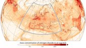
Now that Sentinel-5P is safely in orbit, engineers have started commissioning the satellite for the task of delivering extremely high-quality information on air quality. Meanwhile, the Copernicus Atmosphere Monitoring Service is poised to ensure we all reap the benefits from this latest mission.
20171031 - volné místo - Odborný referent v oddělení podpory ICT v TO na Katastrálním úřadu pro ÚK
31.10.2017 12:45 ČÚZK - předpisy a opatření Katastrální úřad pro Ústecký kraj zveřejnil novou aktualitu: Nabídka volného pracovního místa - Odborný referent v oddělení podpory ICT v technickém odboru na Katastrálním úřadu pro Ústecký kraj20171031 - volné místo - Odborný referent v oddělení podpory ICT v TO na Katastrálním úřadu pro ÚK
31.10.2017 12:45 ČÚZK /Urady/Katastralni-urady/Katastralni-urady/Katastralni-urad-pro-Ustecky-kraj/O-uradu/Aktuality/20171031-volne-misto-Odborny-referent-v-oddeleMapová aplikace Cleerio se umísťuje na stupních vítězů
31.10.2017 10:48 Cleerio Soutěž Chytrá radnice je pořádána pod záštitou Úřadu vlády ČR s cílem vyhodnotit a ocenit nejlepší chytrá řešení v oblasti veřejné správy a samosprávy využívající moderní digitální technologie. Mezi 64 přihlášenými projekty získala mapová aplikace Cleerio 3. místo v ceně veřejnosti. Mapová aplikace tak sklízí úspěch a to nejen u veřejné správy, ale i u veřejnosti, která se mohla v této kategorii podílet na hlasování.Mapová aplikace Cleerio se umísťuje na stupních vítězů
31.10.2017 10:48 CleerioSoutěž Chytrá radnice je pořádána pod záštitou Úřadu vlády ČR s cílem vyhodnotit a ocenit nejlepší chytrá řešení v oblasti veřejné správy a samosprávy využívající moderní digitální technologie. Mezi 64 přihlášenými projekty získala mapová aplikace Cleerio 3. místo v ceně veřejnosti. Mapová aplikace tak sklízí úspěch a to nejen u veřejné správy, ale i u veřejnosti, která se mohla v této kategorii podílet na hlasování.
Příspěvek Mapová aplikace Cleerio se umísťuje na stupních vítězů pochází z CLEERIO
Mapová aplikace Cleerio se umísťuje na stupních vítězů
31.10.2017 10:48 CleerioSoutěž Chytrá radnice je pořádána pod záštitou Úřadu vlády ČR s cílem vyhodnotit a ocenit nejlepší chytrá řešení v oblasti veřejné správy a samosprávy využívající moderní digitální technologie. Mezi 64 přihlášenými projekty získala mapová aplikace Cleerio 3. místo v ceně veřejnosti. Mapová aplikace tak sklízí úspěch a to nejen u veřejné správy, ale i u veřejnosti, která se mohla v této kategorii podílet na hlasování.
Příspěvek Mapová aplikace Cleerio se umísťuje na stupních vítězů pochází z Cleerio
Mapová aplikace Cleerio se umísťuje na stupních vítězů
31.10.2017 10:48 CleerioSoutěž Chytrá radnice je pořádána pod záštitou Úřadu vlády ČR s cílem vyhodnotit a ocenit nejlepší chytrá řešení v oblasti veřejné správy a samosprávy využívající moderní digitální technologie. Mezi 64 přihlášenými projekty získala mapová aplikace Cleerio 3. místo v ceně veřejnosti. Mapová aplikace tak sklízí úspěch a to nejen u veřejné správy, ale i u veřejnosti, která se mohla v této kategorii podílet na hlasování.
Příspěvek Mapová aplikace Cleerio se umísťuje na stupních vítězů pochází z CLEERIO
Mapová aplikace Cleerio se umísťuje na stupních vítězů
31.10.2017 10:48 CleerioSoutěž Chytrá radnice je pořádána pod záštitou Úřadu vlády ČR s cílem vyhodnotit a ocenit nejlepší chytrá řešení v oblasti veřejné správy a samosprávy využívající moderní digitální technologie. Mezi 64 přihlášenými projekty získala mapová aplikace Cleerio 3. místo v ceně veřejnosti. Mapová aplikace tak sklízí úspěch a to nejen u veřejné správy, ale i u veřejnosti, která se mohla v této kategorii podílet na hlasování.
Příspěvek Mapová aplikace Cleerio se umísťuje na stupních vítězů pochází z Cleerio
Halloween crack
31.10.2017 10:10 ESA Observing the Earth
Arguably scarier than ghosts or goblins: a massive crack in the ice shelf close to the Halley VI research station in Antarctica
EGNOS’s annual workshop captures state-of-play and state-of-the-art
31.10.2017 10:04 European GNSS Agency
The EGNOS Annual Workshop is an opportunity to catch up on the latest state-of-play and state-of-the-art in Europe’s satellite-based augmentation system (SBAS). Another year and again goals have been met, there are more and more users and EGNOS continues to forge forward in accuracy and reliability.
The EGNOS User Satisfaction Survey 2016 shows that users were happy with EGNOS’s outstanding performance. The signal (Signal in Space) was available 100% of the time, with excellent monthly performance. Airport authorities spoke highly of the support offered to users, thanking for the speed of their response to any enquiries. GSA Executive Director Carlo des Dorides noted: “EGNOS has a good story to tell, we have 250 airports with more than 450 approach procedures.”
EDAS, which delivers data to users who cannot always view the EGNOS’s satellites (such as in urban canyons) or to support a variety of other value added services, applications and research programmes also worked well, with almost 99% availability.
Watch this: ESSP - EGNOS Satellite Navigation Systems
The workshop offered a chance to hear from users. Dominic Hysam from Easyjet said EGNOS brings great benefits: “It provides precise guidance at airports where we don’t get that currently. It can provide precision approaches at secondary airports; this benefits us from a safety perspective and allows us to operate in different weather conditions, improving accessibility at those airports.” There is ever increasing pressure on airlines to deliver reliable services to their customers. Hysam added: “EGNOS means we are better at getting customers to where they want to go.”
Alexander Desyllas of the Hellenic Civil Aviation Authority, which manages many airports, said: “We are encouraging all to adopt EGNOS now. It brings huge benefits, direct approaches and means not having to depend on conventional ground installations, this is a very important advantage.”
Reaching out
Other sectors are also reaping the benefits. Des Dorides said: “Even if civil aviation is the main natural-market segment, it is proving to be more and more valuable for other sectors, such as maritime and rail. Next year there will be a new regulation coming into place requiring EGNOS and Galileo capability on all new cars produced in Europe.”
Seventy-five percent of maritime receiver models are now SBAS enabled – in the agricultural sector, 80% of European GNSS enabled tractors are using EGNOS.
Reaching further
EGNOS is also reaching further afield. EGNOS technology has been made available to South Korea, to develop its own KASS system and related services. Julien Lapie, who works for the Agency for Air Navigation Safety in Africa and Madagascar (ASECNA), which manages a major part of the African and Indian Ocean airspace, said that EGNOS will bring huge benefits to flight efficiency and safety. Lapie said that this lent itself particularly well to airports in remote areas with difficult access, due to the unrequired local ground infrastructure and staff.
What next?
The GSA and EGNOS never stand still, Des Dorides said: “In the year ahead, we will start with a major technology development that will bring dual-frequency use; and the overlay on Galileo which will bring even more robust and accurate use. This will be ready in 2023-2025.”
Media note: This feature can be republished without charge provided the European GNSS Agency (GSA) is acknowledged as the source at the top or the bottom of the story. You must request permission before you use any of the photographs on the site. If you republish, we would be grateful if you could link back to the GSA website (http://www.gsa.europa.eu).
EGNOS’ annual workshop captures state-of-play and state-of-the-art
31.10.2017 10:04 European GNSS Agency
The EGNOS Annual Workshop is an opportunity to catch up on the latest state-of-play and state-of-the-art in Europe’s satellite-based augmentation system (SBAS). Another year and again goals have been met, there are more and more users and EGNOS continues to forge forward in accuracy and reliability.
The EGNOS User Satisfaction Survey 2016 shows that users were happy with EGNOS’ outstanding performance. The signal (Signal in Space) was available 100% of the time, with excellent monthly performance. Airport authorities spoke highly of the support offered to users, thanking for the speed of their response to any enquiries. GSA Executive Director Carlo des Dorides noted: “EGNOS has a good story to tell, we have 250 airports with more than 450 approach procedures.”
EDAS, which delivers data to users who cannot always view the EGNOS’ satellites (such as in urban canyons) or to support a variety of other value added services, applications and research programmes also worked well, with almost 99% availability.
Watch this: ESSP - EGNOS Satellite Navigation Systems
The workshop offered a chance to hear from users. Dominic Hysam from Easyjet said EGNOS brings great benefits: “It provides precise guidance at airports where we don’t get that currently. It can provide precision approaches at secondary airports; this benefits us from a safety perspective and allows us to operate in different weather conditions, improving accessibility at those airports.” There is ever increasing pressure on airlines to deliver reliable services to their customers. Hysam added: “EGNOS means we are better at getting customers to where they want to go.”
Alexander Desyllas of the Hellenic Civil Aviation Authority, which manages many airports, said: “We are encouraging all to adopt EGNOS now. It brings huge benefits, direct approaches and means not having to depend on conventional ground installations, this is a very important advantage.”
Reaching out
Other sectors are also reaping the benefits. Des Dorides said: “Even if civil aviation is the main natural-market segment, it is proving to be more and more valuable for other sectors, such as maritime and rail. Next year there will be a new regulation coming into place requiring EGNOS and Galileo capability on all new cars produced in Europe.”
Seventy-five percent of maritime receiver models are now SBAS enabled – in the agricultural sector, 80% of European GNSS enabled tractors are using EGNOS.
Reaching further
EGNOS is also reaching further afield. EGNOS technology has been made available to South Korea, to develop its own KASS system and related services. Julien Lapie, who works for the Agency for Air Navigation Safety in Africa and Madagascar (ASECNA), which manages a major part of the African and Indian Ocean airspace, said that EGNOS will bring huge benefits to flight efficiency and safety. Lapie said that this lent itself particularly well to airports in remote areas with difficult access, due to the unrequired local ground infrastructure and staff.
What next?
The GSA and EGNOS never stand still, Des Dorides said: “In the year ahead, we will start with a major technology development that will bring dual-frequency use; and the overlay on Galileo which will bring even more robust and accurate use. This will be ready in 2023-2025.”
Media note: This feature can be republished without charge provided the European GNSS Agency (GSA) is acknowledged as the source at the top or the bottom of the story. You must request permission before you use any of the photographs on the site. If you republish, we would be grateful if you could link back to the GSA website (http://www.gsa.europa.eu).
EGNOS’ annual workshop captures state-of-play and state-of-the-art
31.10.2017 10:04 European GNSS AgencyThe EGNOS Annual Workshop is an opportunity to catch up on the latest state-of-play and state-of-the-art in Europe’s satellite-based augmentation system (SBAS). Another year and again goals have been met, there are more and more users and EGNOS continues to forge forward in accuracy and reliability.
The EGNOS User Satisfaction Survey 2016 shows that users were happy with EGNOS’ outstanding performance. The signal (Signal in Space) was available 100% of the time, with excellent monthly performance. Airport authorities spoke highly of the support offered to users, thanking for the speed of their response to any enquiries. GSA Executive Director Carlo des Dorides noted: “EGNOS has a good story to tell, we have 250 airports with more than 450 approach procedures.”
EDAS, which delivers data to users who cannot always view the EGNOS’ satellites (such as in urban canyons) or to support a variety of other value added services, applications and research programmes also worked well, with almost 99% availability.
Watch this: ESSP - EGNOS Satellite Navigation Systems
The workshop offered a chance to hear from users. Dominic Hysam from Easyjet said EGNOS brings great benefits: “It provides precise guidance at airports where we don’t get that currently. It can provide precision approaches at secondary airports; this benefits us from a safety perspective and allows us to operate in different weather conditions, improving accessibility at those airports.” There is ever increasing pressure on airlines to deliver reliable services to their customers. Hysam added: “EGNOS means we are better at getting customers to where they want to go.”
Alexander Desyllas of the Hellenic Civil Aviation Authority, which manages many airports, said: “We are encouraging all to adopt EGNOS now. It brings huge benefits, direct approaches and means not having to depend on conventional ground installations, this is a very important advantage.”
Reaching out
Other sectors are also reaping the benefits. Des Dorides said: “Even if civil aviation is the main natural-market segment, it is proving to be more and more valuable for other sectors, such as maritime and rail. Next year there will be a new regulation coming into place requiring EGNOS and Galileo capability on all new cars produced in Europe.”
Seventy-five percent of maritime receiver models are now SBAS enabled – in the agricultural sector, 80% of European GNSS enabled tractors are using EGNOS.
Reaching further
EGNOS is also reaching further afield. EGNOS technology has been made available to South Korea, to develop its own KASS system and related services. Julien Lapie, who works for the Agency for Air Navigation Safety in Africa and Madagascar (ASECNA), which manages a major part of the African and Indian Ocean airspace, said that EGNOS will bring huge benefits to flight efficiency and safety. Lapie said that this lent itself particularly well to airports in remote areas with difficult access, due to the unrequired local ground infrastructure and staff.
What next?
The GSA and EGNOS never stand still, Des Dorides said: “In the year ahead, we will start with a major technology development that will bring dual-frequency use; and the overlay on Galileo which will bring even more robust and accurate use. This will be ready in 2023-2025.”
Media note: This feature can be republished without charge provided the European GNSS Agency (GSA) is acknowledged as the source at the top or the bottom of the story. You must request permission before you use any of the photographs on the site. If you republish, we would be grateful if you could link back to the GSA website (http://www.gsa.europa.eu).
Umění schované ve fyzickogeografických mapách
31.10.2017 8:53 GISportal.cz Někteří říkají, že obrázek vydá za tisíc slov. Pro geografy a geoinformatiky však mnohdy obrázek znamená více než to. Tím obrázkem je totiž mapa, která umožní výzkum v časových řadách a zobrazení změn v krajině. ...Prezentovali jsme na konferenci "Fakturace tepla 2017"
31.10.2017 8:46 GIS Fórum Jakub Bican byl jedním z prezentujících na konferenci "Fakturace tepla 2017" pořádané společností EG - Expert.Divize GIS CAD Studia a společnost EG - Expert spolupracují v oblastí vytváření integrací mezi řešeními GIS Teplo a eSADA (zákaznický, výrobní a fakturační informační systém) a právě tomuto tématu byl věnován jeden z bloků konference.

Na přednášku navázal se svým příspěvkem Jakub Bican na téma "Jak efektivně využít datové zdroje ve společnosti prostřednictvím GIS". Hodnota informačních technologiích ve společnosti se zdaleka nerovná hodnotě pořízeného software. Až devadesát procent hodnoty je v datech! A právě efektivní využití dat prostřednictvím GIS, který dokáže data udržovat, integrovat a především publikovat rovná se zhodnocení investic do samotných dat.

Prezentovali jsme na konferenci "Fakturace tepla 2017"
31.10.2017 8:46 GIS Fórum Jakub Bican byl jedním z prezentujících na konferenci "Fakturace tepla 2017" pořádané společností EG - Expert.Divize GIS CAD Studia a společnost EG - Expert spolupracují v oblastí vytváření integrací mezi řešeními GIS Teplo a eSADA (zákaznický, výrobní a fakturační informační systém) a právě tomuto tématu byl věnován jeden z bloků konference.
Na přednášku navázal se svým příspěvkem Jakub Bican na téma "Jak efektivně využít datové zdroje ve společnosti prostřednictvím GIS". Hodnota informačních technologiích ve společnosti se zdaleka nerovná hodnotě pořízeného software. Až devadesát procent hodnoty je v datech! A právě efektivní využití dat prostřednictvím GIS, který dokáže data udržovat, integrovat a především publikovat rovná se zhodnocení investic do samotných dat.
20171031 Vrchní referent/rada oddělení obnovy katastrálního operátu
31.10.2017 8:11 ČÚZK - předpisy a opatření Katastrální úřad pro Středočeský kraj zveřejnil novou aktualitu: bylo vystaveno "Oznámení o vyhlášení výběrového řízení na obsazení služebního místo „vrchní referent/rada oddělení obnovy katastrálního operátu č. 03130 Technické sekce" V části "Úřední deska", v sekci "Oznámení a jiná úřední sdělení" bylo vystaveno "Oznámení o vyhlášení výběrového řízení na obsazení služebního místa Vrchní referent/rada oddělení obnovy katastrálního operátu č. 03130 Technické sekce"20171031 Vrchní referent/rada oddělení obnovy katastrálního operátu
31.10.2017 8:11 ČÚZK /Urady/Katastralni-urady/Katastralni-urady/Katastralni-urad-pro-Stredocesky-kraj/O-uradu/Aktuality/20161013Rada-odborny-rada-–-informatik-(3)Vrchní referent/rada oddělení obnovy katastrálního operátu
31.10.2017 8:08 ČÚZK - volná místa Katastrální úřad pro Středočeský kraj - technická sekce vypisuje výběrové řízení na místo Vrchní referent/rada oddělení obnovy katastrálního operátuVrchní referent/rada oddělení obnovy katastrálního operátu
31.10.2017 8:08 ČÚZK - předpisy a opatření Katastrální úřad pro Středočeský kraj - technická sekcevypisuje výběrové řízení na místo Vrchní referent/rada oddělení obnovy katastrálního operátu
Vrchní referent/rada oddělení obnovy katastrálního operátu
Vrchní referent/rada oddělení obnovy katastrálního operátu
31.10.2017 8:08 ČÚZK /Urady/Katastralni-urady/Katastralni-urady/Katastralni-urad-pro-Stredocesky-kraj/Uredni-deska/Oznameni-a-jina-uredni-sdeleni/Volna-mista/Vrchni-referent-rada-oddeleni-obnovy-katastral-(2)TatukGIS Announces GIS SDK for Java
31.10.2017 8:00 GISCafe.com Webcasts-Webinars The TatukGIS Developer Kernel 11 for Java is now available as an EAP (Early Access Program), making available this new GIS SDK edition as a beta …20171031 Vrchní referent/rada oddělení aktualizace
31.10.2017 7:43 ČÚZK - předpisy a opatření Katastrální úřad pro Středočeský kraj - Katastrální pracoviště Příbram Vyhlášení výběrového řízení: Vrchní referent/rada oddělení aktualizace V části "Úřední deska", v sekci "Oznámení a jiná úřední sdělení" bylo vystaveno "Oznámení o vyhlášení výběrového řízení na obsazení služebního místa Vrchní referent/rada oddělení aktualizace"20171031 Vrchní referent/rada oddělení aktualizace
31.10.2017 7:43 ČÚZK /Urady/Katastralni-urady/Katastralni-urady/Katastralni-urad-pro-Stredocesky-kraj/Katastralni-pracoviste/KP-Pribram/O-uradu/Aktuality/20161013Rada-odborny-rada-–-informatik-(5)Vrchní referent/rada oddělení aktualizace
31.10.2017 7:40 ČÚZK - předpisy a opatření Katastrální úřad pro Středočeský kraj - Katastrální pracoviště Příbramvypisuje výběrové řízení na místo Vrchní referent/rada oddělení aktualizace
Vrchní referent/rada oddělení aktualizace
Vrchní referent/rada oddělení aktualizace
31.10.2017 7:40 ČÚZK - volná místa Katastrální úřad pro Středočeský kraj - Katastrální pracoviště Příbram vypisuje výběrové řízení na místo Vrchní referent/rada oddělení aktualizaceVrchní referent/rada oddělení aktualizace
31.10.2017 7:40 ČÚZK /Urady/Katastralni-urady/Katastralni-urady/Katastralni-urad-pro-Stredocesky-kraj/Uredni-deska/Oznameni-a-jina-uredni-sdeleni/Volna-mista/Vrchni-referent-rada-oddeleni-aktualizaceUZAVŘENÍ PRACOVIŠTĚ
31.10.2017 6:54 ČÚZK - předpisy a opatření Katastrální úřad pro Karlovarský kraj - Katastrální pracoviště Sokolov zveřejnil novou aktualitu:Vážení klienti,
z důvodu celodenního přerušení dodávky elektřiny bude naše pracoviště v pátek 03.11.2017 z technických důvodů uzavřeno.
Omlouváme se za způsobené komplikace a děkujeme za pochopení,
Ing. Martin Raška, Ph.D.
Ředitel Katastrálního pracoviště Sokolov
UZAVŘENÍ PRACOVIŠTĚ
31.10.2017 6:54 ČÚZK /Urady/Katastralni-urady/Katastralni-urady/Katastralni-urad-pro-Karlovarsky-kraj/Katastralni-pracoviste/KP-Sokolov/O-uradu/Aktuality/UZAVRENI-PRACOVISTENew Product Releases and How to Manage Them
31.10.2017 5:30 Carlson Software With the release of the Carlson Survey and Takeoff OEM versions, the full Carlson 2018 product line is now available! While that might excite a lot of users, it may bring apprehension to others. I won’t reiterate the points I wrote in a blog last July entitled, “Why Upgrade Your Software,” but please read it […]Zveme Vás na naše přednášky na GIS ESRI konferenci
31.10.2017 1:00 VARS.czJako každý rok i letos se aktivně účastníme GIS ESRI konference, která se tentokrát koná 8. a 9. listopadu v Praze. Tentokrát vystoupíme se dvěma příspěvky s názvy "Widgety jako doping pro Vaše data" a "Sběr dat pod vodní hladinou a jejich využití".
Global Drone Technology Market in Education Sector 2017-2021: Surge in Volume from Emerging Countries - Research and Markets
30.10.2017 17:47 GISCafe.com Webcasts-Webinars DUBLIN — (BUSINESS WIRE) — October 30, 2017 — The "Global Drone Technology Market in Education Sector 2017-2021" report has been …Next Evolution of Kratos Mako Tactical Unmanned Aerial Drone System Completes Successful Flight Test Series as Part of Large Military Exercise
30.10.2017 17:46 GISCafe.com Webcasts-Webinars SAN DIEGO, Oct. 30, 2017 (GLOBE NEWSWIRE) -- Kratos Defense & Security Solutions, Inc. (Nasdaq:KTOS), a leading National Security Solutions …Trimble Introduces ISOBUS-Compatible GFX-750 Display System with Advanced Guidance Controller for Agriculture Applications
30.10.2017 17:45 GISCafe.com Webcasts-Webinars Enhanced Connectivity with Integrated Wi-Fi and Bluetooth CommunicationsSUNNYVALE, Calif., Oct. 30, 2017 — (PRNewswire) — …
TomTom Share Buyback Periodic Update (23 – 27 October 2017)
30.10.2017 17:45 GISCafe.com Webcasts-Webinars AMSTERDAM — (BUSINESS WIRE) — October 30, 2017 — TomTom (TOM2) today announced that it has repurchased 293,777 ordinary TomTom …The County of San Mateo Uses Data to Blaze a Path to Remarkable Smart City Projects with Commvault
30.10.2017 17:44 GISCafe.com Webcasts-Webinars -By Simplifying Data Management, Protection and Activation on Its Hybrid Cloud, Commvault Helps San Mateo County Provide Its Residents with Access to …GeoSLAM Launches Time & Cost Saving 3D Mobile Laser Scanners at Dallas Fall BIM Forum 2017
30.10.2017 17:43 GISCafe.com Webcasts-Webinars GeoSLAM Launches Time & Cost Saving 3D Mobile Laser Scannersat Dallas Fall BIM Forum 2017
DALLAS, TEXAS – Monday, October 30, …
NYC DoITT Helps Ensure 9-1-1 System Integrity with Support of Airbus DS Communications
30.10.2017 17:43 GISCafe.com Webcasts-Webinars TEMECULA, Calif., Oct. 30, 2017 (GLOBE NEWSWIRE) -- Airbus DS Communications and the New York City Department of Information Technology and …GPSdome to Announce GPS Anti-Jamming & Anti-Spoofing Antenna Module Solution for Timing Systems at ITSF
30.10.2017 17:42 GISCafe.com Webcasts-Webinars CAESAREA, Israel, October 30, 2017 — (PRNewswire) —GPSdome Ltd., the Cyber Company, announced the release of its new product, GPSdome …
Pracovní nabídka v ARCDATA Praha
30.10.2017 17:27 GISportal.cz Aktuálně hned dvě volná místa nabízí ARCDATA Praha na pozici technické podpory. Detaily naleznete zde.Zvaná přednáška člena KGM na akci POOL 2017
30.10.2017 15:42 Blogující geomatici - FAV ZČU Minulý týden prohběhla akce POOL (Podzimní Olomouc) 2017, na kterou jsou zváni odborníci napříč republikou, aby studentům tamní Katedry geomatiky na Univerzitě Palackého v Olomouci přednesli zajímavá témata. Letos mezi nimi zanechal významnou stopu i člen KGM, Ing. Karel Jedlička, Ph.D. s přednáškou na téma "Možnosti navigace uvnitř budov".Zvaná přednáška člena KGM na akci POOL 2017
30.10.2017 15:42 Blogující geomatici - FAV ZČU Minulý týden prohběhla akce POOL (Podzimní Olomouc) 2017, na kterou jsou zváni odborníci napříč republikou, aby studentům tamní Katedry geoinformatiky na Univerzitě Palackého v Olomouci přednesli zajímavá témata. Letos mezi nimi zanechal významnou stopu i člen KGM, Ing. Karel Jedlička, Ph.D. s přednáškou na téma "Možnosti navigace uvnitř budov".Na výstavě "Rokycany a jejich mistr Jan" se podílela i KGM
30.10.2017 15:34 Blogující geomatici - FAV ZČU Západočeské muzeum pořádá v Rokycanech výstavu nazvanou "Rokycany a jejich mistr Jan", na které můžete shlédnout i videosekvenci ukazující tvorbu trojrozměrného modelu rodného domu mistra Jana Rokycany. Více informací naleznete na stránkách muzea zde.Melting snow aids absorption of carbon dioxide
30.10.2017 13:15 ESA Observing the Earth
It appears that something good can come from something bad. Although rising global temperatures are causing seasonal snow cover to melt earlier in the spring, this allows for the snow-free boreal forests to absorb more carbon dioxide from our atmosphere.
Odborný referent v oddělení aktualizace katastru nemovitostí Katastrálního pracoviště Trutnov
30.10.2017 13:04 ČÚZK - volná místa Katastrální úřad pro Královéhradecký kraj - Katastrální pracoviště Trutnov vypisuje výběrové řízení na místo Odborný referent v oddělení aktualizace katastru nemovitostí Katastrálního pracoviště TrutnovOdborný referent v oddělení aktualizace katastru nemovitostí Katastrálního pracoviště Trutnov
30.10.2017 13:04 ČÚZK - předpisy a opatření Katastrální úřad pro Královéhradecký kraj - Katastrální pracoviště Trutnovvypisuje výběrové řízení na místo
Odborný referent v oddělení aktualizace katastru nemovitostí Katastrálního pracoviště Trutnov
Last chance to start your Space3ac adventure and apply for financial support
30.10.2017 11:41 European GNSS Agency
The latest recruitment drive for Space3ac, a three-month acceleration programme for start-ups using satellite technologies to create solutions for the intermodal transportation, oil and gas and insurance sectors, is set to end at midnight on Tuesday, 31 October 2017. Interested start-ups with capabilities to solve problems provided by industry partners should “raise their hands” and register (by filling out a short form) on the programme’s website. The recruitment process will continue with interviews and meetings on 20-21 November.
The Space3ac programme aims to solve problems experienced by transportation, oil and gas and insurance industry stakeholders by connecting them to start-ups with new ideas based on Earth observation, GNSS, telecommunications or integrated applications. In addition to PLN 200 000 (EUR 47,000) in cash, the start-ups will receive access to over 40 international technical and business mentors, be given a place to develop their business ideas, and be introduced to investors from all over the world.
Basic space industry knowledge required
The programme is looking for teams that have an early prototype or minimum viable product (MVP) of their solution, with a technology readiness level of at least 2. The teams should also have at least basic knowledge of the space industry and downstream sector and include experts with multidisciplinary skills. You can find all of the terms and conditions for participation here.
Some of the more than 30 problems that the start-ups will aim to resolve include designing and implementing an intelligent monitoring system for the electrical power system at the Port of Gdynia; intelligent surveillance of safe navigation in the inner harbour of the Port of Gdansk; and an IT system allowing the handling of wheeled vehicle transport for OT Logistics, among others. The full list of problems to be solved is available on the website.
In the second call, the programme has money to support 13 start-ups. Initially, at least 18 will be invited to take part in the programme and, after the first month of the acceleration phase a decision will be made on which teams can advance further. The selected projects will work for three months to develop their business, after which they will have an opportunity to pitch their ideas and attract investors to develop their business further.
For more information, check out the programme’s website.
Media note: This feature can be republished without charge provided the European GNSS Agency (GSA) is acknowledged as the source at the top or the bottom of the story. You must request permission before you use any of the photographs on the site. If you republish, we would be grateful if you could link back to the GSA website (http://www.gsa.europa.eu).
Last chance to start your Space3ac adventure and apply for financial support
30.10.2017 11:41 European GNSS AgencyThe latest recruitment drive for Space3ac, a three-month acceleration programme for start-ups using satellite technologies to create solutions for the intermodal transportation, oil and gas and insurance sectors, is set to end at midnight on Friday, November 3. Interested start-ups with capabilities to solve problems provided by industry partners should “raise their hands” and register (by filling out a short form) on the programme’s website. The recruitment process will continue with interviews and meetings on 20-21 November.
The Space3ac programme aims to solve problems experienced by transportation, oil and gas and insurance industry stakeholders by connecting them to start-ups with new ideas based on Earth observation, GNSS, telecommunications or integrated applications. In addition to PLN 200 000 (EUR 47,000) in cash, the start-ups will receive access to over 40 international technical and business mentors, be given a place to develop their business ideas, and be introduced to investors from all over the world.
Basic space industry knowledge required
The programme is looking for teams that have an early prototype or minimum viable product (MVP) of their solution, with a technology readiness level of at least 2. The teams should also have at least basic knowledge of the space industry and downstream sector and include experts with multidisciplinary skills. You can find all of the terms and conditions for participation here.
Some of the more than 30 problems that the start-ups will aim to resolve include designing and implementing an intelligent monitoring system for the electrical power system at the Port of Gdynia; intelligent surveillance of safe navigation in the inner harbour of the Port of Gdansk; and an IT system allowing the handling of wheeled vehicle transport for OT Logistics, among others. The full list of problems to be solved is available on the website.
In the second call, the programme has money to support 13 start-ups. Initially, at least 18 will be invited to take part in the programme and, after the first month of the acceleration phase a decision will be made on which teams can advance further. The selected projects will work for three months to develop their business, after which they will have an opportunity to pitch their ideas and attract investors to develop their business further.
For more information, check out the programme’s website.
Media note: This feature can be republished without charge provided the European GNSS Agency (GSA) is acknowledged as the source at the top or the bottom of the story. You must request permission before you use any of the photographs on the site. If you republish, we would be grateful if you could link back to the GSA website (http://www.gsa.europa.eu).
Last chance to start your Space3ac adventure and apply for financial support
30.10.2017 11:41 European GNSS AgencyThe latest recruitment drive for Space3ac, a three-month acceleration programme for start-ups using satellite technologies to create solutions for the intermodal transportation, oil and gas and insurance sectors, is set to end at midnight on Tuesday, 31 October 2017. Interested start-ups with capabilities to solve problems provided by industry partners should “raise their hands” and register (by filling out a short form) on the programme’s website. The recruitment process will continue with interviews and meetings on 20-21 November.
The Space3ac programme aims to solve problems experienced by transportation, oil and gas and insurance industry stakeholders by connecting them to start-ups with new ideas based on Earth observation, GNSS, telecommunications or integrated applications. In addition to PLN 200 000 (EUR 47,000) in cash, the start-ups will receive access to over 40 international technical and business mentors, be given a place to develop their business ideas, and be introduced to investors from all over the world.
Basic space industry knowledge required
The programme is looking for teams that have an early prototype or minimum viable product (MVP) of their solution, with a technology readiness level of at least 2. The teams should also have at least basic knowledge of the space industry and downstream sector and include experts with multidisciplinary skills. You can find all of the terms and conditions for participation here.
Some of the more than 30 problems that the start-ups will aim to resolve include designing and implementing an intelligent monitoring system for the electrical power system at the Port of Gdynia; intelligent surveillance of safe navigation in the inner harbour of the Port of Gdansk; and an IT system allowing the handling of wheeled vehicle transport for OT Logistics, among others. The full list of problems to be solved is available on the website.
In the second call, the programme has money to support 13 start-ups. Initially, at least 18 will be invited to take part in the programme and, after the first month of the acceleration phase a decision will be made on which teams can advance further. The selected projects will work for three months to develop their business, after which they will have an opportunity to pitch their ideas and attract investors to develop their business further.
For more information, check out the programme’s website.
Media note: This feature can be republished without charge provided the European GNSS Agency (GSA) is acknowledged as the source at the top or the bottom of the story. You must request permission before you use any of the photographs on the site. If you republish, we would be grateful if you could link back to the GSA website (http://www.gsa.europa.eu).
Last chance to start your Space3ac adventure and apply for financial support
30.10.2017 11:41 European GNSS AgencyThe latest recruitment drive for Space3ac, a three-month acceleration programme for start-ups using satellite technologies to create solutions for the intermodal transportation, oil and gas and insurance sectors, is set to end at midnight on Tuesday, October 31. Interested start-ups with capabilities to solve problems provided by industry partners should “raise their hands” and register (by filling out a short form) on the programme’s website. The recruitment process will continue with interviews and meetings on 20-21 November.
The Space3ac programme aims to solve problems experienced by transportation, oil and gas and insurance industry stakeholders by connecting them to start-ups with new ideas based on Earth observation, GNSS, telecommunications or integrated applications. In addition to PLN 200 000 (EUR 47,000) in cash, the start-ups will receive access to over 40 international technical and business mentors, be given a place to develop their business ideas, and be introduced to investors from all over the world.
Basic space industry knowledge required
The programme is looking for teams that have an early prototype or minimum viable product (MVP) of their solution, with a technology readiness level of at least 2. The teams should also have at least basic knowledge of the space industry and downstream sector and include experts with multidisciplinary skills. You can find all of the terms and conditions for participation here.
Some of the more than 30 problems that the start-ups will aim to resolve include designing and implementing an intelligent monitoring system for the electrical power system at the Port of Gdynia; intelligent surveillance of safe navigation in the inner harbour of the Port of Gdansk; and an IT system allowing the handling of wheeled vehicle transport for OT Logistics, among others. The full list of problems to be solved is available on the website.
In the second call, the programme has money to support 13 start-ups. Initially, at least 18 will be invited to take part in the programme and, after the first month of the acceleration phase a decision will be made on which teams can advance further. The selected projects will work for three months to develop their business, after which they will have an opportunity to pitch their ideas and attract investors to develop their business further.
For more information, check out the programme’s website.
Media note: This feature can be republished without charge provided the European GNSS Agency (GSA) is acknowledged as the source at the top or the bottom of the story. You must request permission before you use any of the photographs on the site. If you republish, we would be grateful if you could link back to the GSA website (http://www.gsa.europa.eu).
Esri uvolnilo webovou aplikaci pro interpretaci snímků DPZ
30.10.2017 10:37 GISportal.cz Svět GIS se pomalu ale jistě otevírá a tento trend dodržuje i největší z největších, americká firma Esri. Tato společnost totiž nedávno uvolnila beta verzi šablony webové aplikace pro interpretaci snímků pořízených v rámci dálkového ...Přerušení provozu Sbírky listin v DP 2.11.2017
30.10.2017 9:26 ČÚZK /Aplikace-DP-do-KN/Aplikace-DP-do-KN/Archiv-DP/196772Přerušení provozu Sbírky listin v DP 2.11.2017
30.10.2017 9:26 ČÚZK - předpisy a opatření Vážení uživatelé, oznamujeme, že ve čtvrtek 2.11.2017 od 16:30 do cca 21:00 nebudou z provozních důvodů dostupné dokumenty ze Sbírky listin. Za komplikace tímto způsobené se omlouváme a děkujeme za pochopení.Přerušení provozu Sbírky listin v DP 2.11.2017
30.10.2017 9:26 Dálkový přístup k údajům KN ČR Vážení uživatelé, oznamujeme, že ve čtvrtek 2.11.2017 od 16:30 do cca 21:00 nebudou z provozních důvodů dostupné dokumenty ze Sbírky listin. Za komplikace tímto způsobené se omlouváme a děkujeme za pochopení.Video: Interview with Jaroslav Polacek, Product Manager at T-MARY during 2017 Intergeo Conference
30.10.2017 8:00 GISCafe.com Webcasts-WebinarsINSPIRE téma Rozšířené Parcely (CPX)
30.10.2017 1:00 Cenia - Katalog metadat ČR - INSPIRE Rozšíření má za cíl poskytovat katastrální mapu s obsahem podle vyhlášky ve vektorové podobě ve struktuře plně v souladu se strukturou danou směrnicí INSPIRE. Data rozšiřují směrnici INSPIRE pro téma katastrální parcely (CP) o věcná břemena, geodetické body, další prvky mapy, původní obloukovou geometrii a o parcely určené definičním bodem (ty pouze v oblastech s analogovou mapou). Vychází z katastrální mapy, která je závazným státním mapovým dílem velkého měřítka, obsahuje body polohového bodového pole, polohopis a popis a může mít formu digitální mapy, analogové mapy nebo digitalizované mapy. Publikovaná data obsahují katastrální území pro celou Českou Republiku, parcely a jejich hranice, věcná břemena, další prvky mapy a původní obloukovou geometrii z území, kde je digitální mapa (k 30. 10. 2017 je to 93,13% území České republiky, t.j. 73 445,79km2) a ve zbytku území katastrální parcely určené pouze definičním bodem (tedy bez hranic a polygonu). Katastrální parcely a hranice obsahují oproti datové sadě INSPIRE některé atributy navíc. Jedná se o typ hranice, způsob využití území, druh pozemku, vazbu na budovu a o mapové značky. Více katastrální zákon 344/1992 SB., katastrální vyhláška č.26/2007 Sb. v platném znění a INSPIRE Data Specification on Cadastral Parcels v 3.0.1. Data ve formátu GML 3.2.1 jsou validní proti schématu XML pro Rozšířené Parcely (CPX) ve verzi 4.0.INSPIRE téma Budovy (BU)
30.10.2017 1:00 Cenia - Katalog metadat ČR - INSPIRE Data odpovídají směrnici INSPIRE pro téma budovy (BU). Data pochází částečně z projektu RÚIAN (Registr územní identifikace, adres a nemovitostí), který je součástí základních registrů České Republiky a obsahuje informace o územní identifikaci, adresách a nemovitostech, a částečně z ISKN (Informační systém katastru nemovistostí). Zdrojem informací o budovách v ISKN je objekt Stavba, v RÚIAN je to Stavební objekt. Většina Staveb je zároveň Stavebními objekty, ale jsou případy, kdy tomu tak není. Kromě Budov datová sada obsahuje i části budov, které jsou pro potřeby INSPIRE vyjádřeny vchody z RÚIAN. Vchody obsahují informace o počtu podlaží, technickoekonomických atributech apod. Datová sada pokrývá celé území české republiky. V datové sadě není uvedeno 1,76%, t.j. 74295 budov (k 30. 10. 2017), protože neobsahují definiční bod ani polygon. Více v zákoně č. 111/2009 Sb., o základních registrech, ve vyhlášce č. 359/2011 Sb., o základním registru územní identifikace, adres a nemovitostí v platných zněních, v zákoně 256/2013 Sb., o katastru nemovitostí, v katastrální vyhlášce č. 357/2013 Sb. v platném znění a INSPIRE Data Specification on Buildings v 3.0 z 13.12.2013. Data ve formátu GML 3.2.1 jsou validní proti schématu XML pro INSPIRE téma Budovy ve verzi 4.0 a proti schématu pro prostorová data ELF ve verzi 1.0.INSPIRE téma Adresy (AD)
30.10.2017 1:00 Cenia - Katalog metadat ČR - INSPIRE Data odpovídají směrnici INSPIRE pro téma adresy (AD). Vychází především z projektu RÚIAN (Registr územní identifikace, adres a nemovitostí), který je součástí základních registrů České Republiky a obsahuje informace o územní identifikaci, adresách a nemovitostech. Data publikovaná v rámci INSPIRE obsahují pouze adresní místa a jejich komponenty, kterými jsou stát, obec, část obce, městský obvod v Praze (MOP), městký obvod/městská část (MO/MČ), ulice a pošta a to na území celé České Republiky. Obsahují rozvněž geometrii, která určuje definiční bod adresního místa. V datové sadě nění uvedeno 1,90%, t.j. 55143 adresních míst (k 30. 10. 2017), protože neobsahují definiční bod, podle kterého by je bylo možné prostorově určit. Více v zákoně č. 111/2009 Sb., o základních registrech a ve vyhlášce č. 359/2011 Sb., o základním registru územní identifikace, adres a nemovitostí v platných zněních a INSPIRE Data Specification on Addresses v 3.0.1 z 26.4.2010. Data ve formátu GML 3.2.1 jsou validní proti schématu XML pro INSPIRE téma Adresy ve verzi 4.0 a proti schématu pro prostorová data ELF ve verzi 1.0.INSPIRE téma Parcely (CP)
30.10.2017 1:00 Cenia - Katalog metadat ČR - INSPIRE Data odpovídají směrnici INSPIRE pro téma katastrální parcely (CP). Vychází z katastrální mapy, která je závazným státním mapovým dílem velkého měřítka, obsahuje body polohového bodového pole, polohopis a popis a může mít formu digitální mapy, analogové mapy nebo digitalizované mapy. Data publikovaná v rámci INSPIRE obsahují pouze katastrální území (pro celou Českou Republiku) a parcely a jejich hranice z území, kde je digitální mapa (k 30. 10. 2017 je to 93,13% území České republiky, t.j. 73 445,79km2). Více katastrální zákon 344/1992 SB., katastrální vyhláška č.26/2007 Sb. v platném znění a INSPIRE Data Specification on Cadastral Parcels v 3.0.1. Data ve formátu GML 3.2.1 jsou validní proti schématu XML pro INSPIRE téma Parcely ve verzi 4.0 a proti schématu pro prostorová data ELF ve verzi 1.0.Tající sníh pomáhá absorpci oxidu uhličitého
30.10.2017 1:00 Český Kosmický PortálZdá se, že něco špatného s sebou přináší i něco dobrého. Ač růst globální teploty způsobuje dřívější tání sezónní sněhové pokrývky, zároveň dovoluje sněhem nepokrytým severským lesům absorbovat více oxidu uhličitého z atmosféry.
Katastrální mapa ve formátech DGN a DXF poskytovaná v e-shopu
30.10.2017 1:00 Cenia - Katalog metadat ČR - INSPIRE Katastrální mapa je závazným státním mapovým dílem velkého měřítka, obsahuje body polohového bodového pole, polohopis a popis. Katastrální mapa ve vektorové podobě je poskytována zdarma ve formátu DGN a DXF a obsahuje prvky Digitální katastrální mapy (DKM) a Katastrální mapy digitalizované (KMD), tedy bodová pole, budovy, další prvky mapy, hranice parcel, katastrální hranice, parcely katastru nemovitostí, prvky orientační mapy a hranice věcného břemene. Z důvodu použití formátu DGN produkt neobsahuje značky na liniích a oblouky jsou nahrazeny lomenými čárami. Katastrální mapa ve vektorové podobě k 30. 10. 2017 pokrývá 93,13% území České republiky, t.j. 73 445,79km2. Více katastrální vyhláška č.357/2013 Sb. v platném znění.Katastrální mapa v rastrové podobě poskytovaná v e-shopu
30.10.2017 1:00 Cenia - Katalog metadat ČR - INSPIRE Katastrální mapa v rastrové podobě je poskytována za úplatu a obsahuje analogovou mapu s kompletní kresbou. Analogová mapa pokrývá 5,60 % území České republiky, což je 4 413,67km2. Více katastrální vyhláška č.357/2013 Sb. v platném znění.INSPIRE stahovací služba WFS pro téma Rozšířené Parcely (CPX)
30.10.2017 1:00 Cenia - Katalog metadat ČR - INSPIRE Stahovací služba pro Rozšířené Parcely (CPX) je veřejná stahovací služba pro poskytování dat z Informačního systému katastru nemovitostí (ISKN), umožňující uživatelům opakované stahování těchto dat v souborech po katastrálních územích a online přístup k těmto datům pomocí technologie WFS 2.0.0. Stahovací služba poskytuje harmonizovaná data Rozšířených Parcel (CPX) ve formátu GML vycházející z INSPIRE. Služba je dostupná pro celé území České republiky. Publikovaná data obsahují katastrální území pro celou Českou Republiku, parcely a jejich hranice, věcná břemena, další prvky mapy a původní obloukovou geometrii z území, kde je digitální mapa (k 30. 10. 2017 je to 93,13% území České republiky, t.j. 73 445,79km2) a ve zbytku území katastrální parcely určené pouze definičním bodem (tedy bez hranic a polygonu) jako analogové parcely. Služba splňuje technické pokyny pro INSPIRE stahovací služby verze 3.0.1 a zároveň splňuje standard OGC WFS 2.0.0.Vertikální elektrické sondy (VES)
30.10.2017 1:00 Cenia - Katalog metadat ČR - INSPIRE WMS služba znázorňuje lokalizace měřících stanovišť vertikálního elektrického sondování (VES) v ČR od roku 1957. WMS je ve stádiu tvorby - bude veřejná.Oznámení o vyhlášení výběrového řízení na služební místo odborný rada oddělení řízení pozemkových úprav, odbor metodiky pozemkových úprav
30.10.2017 0:00 Státní pozemkový úřad Ústřední ředitelka Státního pozemkového úřadu, jako služební orgán příslušný podle § 10 odst. 1 písm. f) zákona č. 234/2014 Sb., o státní službě (dále jen „zákon“), vyhlašuje výběrové řízení na služební místo odborný rada oddělení řízení pozemkových úprav, odbor metodiky pozemkových úprav.Oznámení o vyhlášení výběrového řízení na služební místo odborný rada oddělení bezpečnosti
30.10.2017 0:00 Státní pozemkový úřad Ústřední ředitelka Státního pozemkového úřadu, jako služební orgán příslušný podle § 10 odst. 1 písm. f) zákona č. 234/2014 Sb., o státní službě (dále jen „zákon“), vyhlašuje výběrové řízení na služební místo odborný rada oddělení bezpečnosti.Oznámení o vyhlášení výběrového řízení na služební místo rada/odborný rada oddělení pozemkových úprav, Krajský pozemkový úřad pro Moravskoslezský kraj
30.10.2017 0:00 Státní pozemkový úřad Ústřední ředitelka Státního pozemkového úřadu, jako služební orgán příslušný podle § 10 odst. 1 písm. f) zákona č. 234/2014 Sb., o státní službě (dále jen „zákon“), vyhlašuje výběrové řízení na služební místo rada/odborný rada oddělení pozemkových úprav, Krajský pozemkový úřad pro Moravskoslezský kraj.Mapujte stromy svobody
28.10.2017 0:00 Zeměměřič Oslavte příští rok sto let od vzniku Československa a připomeňte si demokratické hodnoty, na nichž Česká republika stojí. Oslavte místo, kde můžeme žít.Symbolem kampaně jsou stromy, které lidé vysadili u příležitosti vzniku Československa v letech 1918, 1919 a také později v roce 1928, 1945 či 1968. Pomozte je zmapovat.
Mapujte stromy svobody
28.10.2017 0:00 Zeměměřič Oslavte přítí rok sto let od vzniku Československa a připomeňte si demokratické hodnoty, na nich Česká republika stojí. Oslavte místo, kde můeme ít.Symbolem kampaně jsou stromy, které lidé vysadili u příleitosti vzniku Československa v letech 1918, 1919 a také později v roce 1928, 1945 či 1968. Pomozte je zmapovat.
From the Highest Mountaintop to the Arabian Desert with Geospatial (ESRI)
27.10.2017 18:40 GISCafe.com Webcasts-WebinarsOGC supports American Geographical Society’s 2017 Fall Symposium, Geography 2050
27.10.2017 18:39 GISCafe.com Webcasts-Webinars 26 October 2017: The Open Geospatial Consortium (OGC) and symposium partners the American Geographical Society (AGS), GEO, and USGIF will …Garmin® acquires Navionics®
27.10.2017 17:03 GISCafe.com Webcasts-Webinars Premier supplier of electronic navigational charts for marinersSCHAFFHAUSEN, Switzerland — (BUSINESS WIRE) — October 27, 2017 …
Unikátní příležitost pro studenty středních škol: navrhněte experiment pro družici Pilsen CUBE II!
27.10.2017 12:57 Český Kosmický PortálMěsto Plzeň ve spolupráci se Západočeskou univerzitou v Plzni spustilo unikátní projekt studentské družice Pilsen CUBE II, který nemá v České republice obdoby. Středoškoláci mají za úkol navrhnout vesmírné experimenty, ty nejlepší pak budou v roce 2018 na palubě družice vyslány na oběžnou dráhu.
"From the Highest Mountaintop to the Arabian Desert with Geospatial" by Susan Smith
27.10.2017 12:49 GISCafe.com Webcasts-WebinarsOdborný referent v oddělení právních vztahů
27.10.2017 12:11 ČÚZK /Urady/Katastralni-urady/Katastralni-urady/Katastralni-urad-pro-Liberecky-kraj/Uredni-deska/Oznameni-a-jina-uredni-sdeleni/Volna-mista/Odborny-referent-v-oddeleni-pravnich-vztahu-(3)Odborný referent v oddělení právních vztahů
27.10.2017 12:11 ČÚZK - předpisy a opatření Katastrální úřad pro Liberecký kraj - Katastrální pracoviště Jablonec nad Nisouvypisuje výběrové řízení na místo
Odborný referent v oddělení právních vztahů
Odborný referent v oddělení právních vztahů
27.10.2017 12:11 ČÚZK - volná místa Katastrální úřad pro Liberecký kraj - Katastrální pracoviště Jablonec nad Nisou vypisuje výběrové řízení na místo Odborný referent v oddělení právních vztahůSoutěžte na Gisportálu o podepsanou knihu 222 tipů a triků pro drony od Jakuba Karase
27.10.2017 12:01 UpVision Na webových stránkách Gisportálu se koná soutěž o podepsanou novou knihu Jakuba Karase 222 tipů a triků pro drony.Více informací zde:
http://www.gisportal.cz/2017/10/soutez-o-knihu-222-tipu-a-triku-pro-drony/
Mapová aplikace byla aktualiz
27.10.2017 12:00 Jihočeský kraj Mapová aplikace byla aktualizována k 26. 10. 2017.Mapová aplikace Územně analyti
27.10.2017 12:00 Jihočeský kraj Mapová aplikace Územně analytické podklady byla aktualizována k 26. 10. 2017.Referent KN – zápis do protokolu řízení V a Z
27.10.2017 11:18 ČÚZK - volná místa Katastrální úřad pro hlavní město Prahu - Katastrální pracoviště Praha vypisuje výběrové řízení na místo Referent KN – zápis do protokolu řízení V a ZReferent KN – zápis do protokolu řízení V a Z
27.10.2017 11:18 ČÚZK /Urady/Katastralni-urady/Katastralni-urady/Katastralni-urad-pro-hlavni-mesto-Prahu/Uredni-deska/Oznameni-a-jina-uredni-sdeleni/Volna-mista/Referent-KN-–-navrh-zapisu,-kontrola-a-zplatneniReferent KN – zápis do protokolu řízení V a Z
27.10.2017 11:18 ČÚZK - předpisy a opatření Katastrální úřad pro hlavní město Prahu - Katastrální pracoviště Prahavypisuje výběrové řízení na místo
Referent KN – zápis do protokolu řízení V a Z
KÚ-08527/2017-100-1001
27.10.2017 11:09 ČÚZK - předpisy a opatření Katastrální úřad pro hlavní město Prahu - Katastrální pracoviště Praha zveřejnil novou aktualitu: Nově vyhlášené výběrové řízení na služební pozici:* Referent KN – návrh zápisu, kontrola a zplatnění
KÚ-08527/2017-100-1001
27.10.2017 11:09 ČÚZK /Urady/Katastralni-urady/Katastralni-urady/Katastralni-urad-pro-hlavni-mesto-Prahu/O-uradu/Aktuality/KU-08527-2017-100-1001Earth from Space
27.10.2017 10:05 ESA Observing the Earth
Explore the US capital with Sentinel-2 in this week's edition of the Earth from Space video programme
Washington DC
27.10.2017 10:05 ESA Observing the Earth
Earth observation image of the week: the US capital city of Washington DC captured by Sentinel-2
Video: Interview with Toby Potter, Enterprise Sales Manager at PrecisionHawk during 2017 Intergeo Conference
27.10.2017 9:00 GISCafe.com Webcasts-Webinars20171204 Vrchní referent/rada oddělení aktualizace katastru nemovitostí Katastrálního pracoviště Pří
27.10.2017 8:11 ČÚZK /Urady/Katastralni-urady/Katastralni-urady/Katastralni-urad-pro-Stredocesky-kraj/Katastralni-pracoviste/KP-Praha-zapad/O-uradu/Aktuality/20161013Rada-odborny-rada-–-informatik-(7)20171124 Rada/ odborný rada v právním oddělení odboru právních vztahů k nemovitostem
27.10.2017 8:11 ČÚZK /Urady/Katastralni-urady/Katastralni-urady/Katastralni-urad-pro-Stredocesky-kraj/Katastralni-pracoviste/KP-Praha-zapad/O-uradu/Aktuality/20161013Rada-odborny-rada-–-informatik-(7)20171204 Vrchní referent/rada oddělení aktualizace katastru nemovitostí Katastrálního pracoviště Pří
27.10.2017 8:11 ČÚZK - předpisy a opatření Katastrální úřad pro Středočeský kraj - Katastrální pracoviště Příbram Oznámení o vyhlášení výběrového řízení: vrchní referent/rada oddělení aktualizace katastru nemovitostí Katastrálního pracoviště Příbram V části "Úřední deska", v sekci "Oznámení a jiná úřední sdělení" bylo vystaveno "Oznámení o vyhlášení výběrového řízení na obsazení služebního místa vrchní referent/rada oddělení aktualizace katastru nemovitostí"20171027 Referent/ka katastru nemovitostí – PRÁVNÍK
27.10.2017 8:11 ČÚZK /Urady/Katastralni-urady/Katastralni-urady/Katastralni-urad-pro-Stredocesky-kraj/Katastralni-pracoviste/KP-Praha-zapad/O-uradu/Aktuality/20161013Rada-odborny-rada-–-informatik-(7)20171027 Referent/ka katastru nemovitostí – PRÁVNÍK
27.10.2017 8:11 ČÚZK - předpisy a opatření Katastrální úřad pro Středočeský kraj - Katastrální pracoviště Praha-západ Oznámení o vyhlášení výběrového řízení: REFERENT/KA KATASTRU NEMOVITOSTÍ - PRÁVNÍK V části "Úřední deska", v sekci "Oznámení a jiná úřední sdělení" bylo vystaveno "Oznámení o vyhlášení výběrového řízení na obsazení systemizovaného místa REFERENT/KA KATASTRU NEMOVITOSTÍ - PRÁVNÍK"20171124 Rada/ odborný rada v právním oddělení odboru právních vztahů k nemovitostem
27.10.2017 8:11 ČÚZK - předpisy a opatření Katastrální úřad pro Středočeský kraj - Katastrální pracoviště Praha-západ Oznámení o vyhlášení výběrového řízení: rada/ odborný rada v právním oddělení odboru právních vztahů k nemovitostem V části "Úřední deska", v sekci "Oznámení a jiná úřední sdělení" bylo vystaveno "Oznámení o vyhlášení výběrového řízení na obsazení služebního místa rada/ odborný rada v právním oddělení odboru právních vztahů k nemovitostem"REFERENT/KA KATASTRU NEMOVITOSTÍ - PRÁVNÍK
27.10.2017 8:10 ČÚZK - volná místa Katastrální úřad pro Středočeský kraj - Katastrální pracoviště Praha-západ vypisuje výběrové řízení na místo REFERENT/KA KATASTRU NEMOVITOSTÍ - PRÁVNÍKREFERENT/KA KATASTRU NEMOVITOSTÍ - PRÁVNÍK
27.10.2017 8:10 ČÚZK - předpisy a opatření Katastrální úřad pro Středočeský kraj - Katastrální pracoviště Praha-západvypisuje výběrové řízení na místo REFERENT/KA KATASTRU NEMOVITOSTÍ - PRÁVNÍK
REFERENT/KA KATASTRU NEMOVITOSTÍ - PRÁVNÍK
REFERENT/KA KATASTRU NEMOVITOSTÍ - PRÁVNÍK
27.10.2017 8:10 ČÚZK /Urady/Katastralni-urady/Katastralni-urady/Katastralni-urad-pro-Stredocesky-kraj/Volna-mista/REFERENT-KA-KATASTRU-NEMOVITOSTI-PRAVNIK-(1)Navigace před sto lety
27.10.2017 8:07 GISportal.cz Dlouho před vznikem GPS – ve 20. letech minulého století vznikla osobní přenosná navigace ukrytá v hodinkách – „Plus Fours Routefinder“. Navigace tedy nebyla umístěna přímo v hodinkách, ale místo hodinek byl na koženém pásku na ...Ochutnávka přednášek ze Setkání GEPRO & ATLAS
27.10.2017 2:23 GEPROSetkání uživatelů produktů a služeb společností GEPRO a ATLAS je za námi.… >>