


![]()

zprávy
zdroje zpráv:Volné místo - specialista datového skladu a GIS
23.3.2017 7:00 Česká asociace pro geoinformace Ústav pro hospodářskou úpravu lesů hledá pracovníka na místo Specialista datového skladu a GIS v Brandýse nad Labem.Požadujeme:
absolvent SŠ/VOŠ/VŠ
občanská bezúhonnost
dobrý zdravotní stav
řidičský průkaz skupiny B a znalost cizího jazyka výhodou
Odborné požadavky a dovednosti:
schopnost analyzovat a řešit GIS úlohy v rámci informačního a datového
Oznámení o vyhlášení výběrového řízení na služební místo odborný rada oddělení administrace ICT a infrastruktury, odbor provozu ICT a technické infrastruktury (server administrátor)
23.3.2017 0:00 Státní pozemkový úřad Ústřední ředitelka Státního pozemkového úřadu, jako služební orgán příslušný podle § 10 odst. 1 písm. f) zákona č. 234/2014 Sb., o státní službě (dále jen „zákon“), vyhlašuje výběrové řízení na služební místo odborný rada oddělení administrace ICT a infrastruktury, odbor provozu ICT a technické infrastruktury.Oznámení o vyhlášení výběrového řízení na služební místo odborný rada, oddělení pozemkových úprav, Krajský pozemkový úřad pro Karlovarský kraj
23.3.2017 0:00 Státní pozemkový úřad Ústřední ředitelka Státního pozemkového úřadu, jako služební orgán příslušný podle § 10 odst. 1 písm. f) zákona č. 234/2014 Sb., o státní službě (dále jen „zákon“), vyhlašuje výběrové řízení na služební místo odborný rada, oddělení pozemkových úprav, Krajský pozemkový úřad pro Karlovarský kraj.Oznámení o vyhlášení výběrového řízení na služební místo ředitel sekce odborných činností
23.3.2017 0:00 Státní pozemkový úřad Ústřední ředitelka Státního pozemkového úřadu, jako služební orgán příslušný podle § 10 odst. 1 písm. f) zákona č. 234/2014 Sb., o státní službě (dále jen „zákon“), vyhlašuje výběrové řízení na služební místo ředitel sekce odborných činností.Oznámení o vyhlášení výběrového řízení na služební místo odborný rada oddělení bezpečnosti
23.3.2017 0:00 Státní pozemkový úřad Ústřední ředitelka Státního pozemkového úřadu, jako služební orgán příslušný podle § 10 odst. 1 písm. f) zákona č. 234/2014 Sb., o státní službě (dále jen „zákon“), vyhlašuje výběrové řízení na služební místo odborný rada oddělení bezpečnosti.Oznámení o vyhlášení výběrového řízení (18)
22.3.2017 17:50 ČÚZK /Urady/Katastralni-urady/Katastralni-urady/Katastralni-urad-pro-Zlinsky-kraj/O-uradu/Aktuality/Oznameni-o-vyhlaseni-vyberoveho-rizeni-(18)Oznámení o vyhlášení výběrového řízení (18)
22.3.2017 17:50 ČÚZK - předpisy a opatřeníOznámení o vyhlášení výběrového řízení (17)
22.3.2017 17:44 ČÚZK /Urady/Katastralni-urady/Katastralni-urady/Katastralni-urad-pro-Zlinsky-kraj/O-uradu/Aktuality/Oznameni-o-vyhlaseni-vyberoveho-rizeni-(17)Oznámení o vyhlášení výběrového řízení (17)
22.3.2017 17:44 ČÚZK - předpisy a opatřeníodborný referent/vrchní referent – operátor informačních a komunikačních technologií (analytik infor
22.3.2017 15:36 ČÚZK - předpisy a opatření Katastrální úřad pro Zlínský krajvypisuje výběrové řízení na místo odborný referent/vrchní referent – operátor informačních a komunik
odborný referent/vrchní referent – operátor informačních a komunikačních technologií (analytik informačních systémů) v oddělení podpory informačních a komunikačních technologií KÚ pro Zlínský kraj
odborný referent / vrchní referent – operátor informačních a komunikačních technologií (analytik inf
22.3.2017 15:36 ČÚZK - volná místa Katastrální úřad pro Zlínský kraj, vypisuje výběrové řízení na místo odborný referent / vrchní referent – operátor informačních a komunikačních technologií (analytik infodborný referent / vrchní referent – operátor informačních a komunikačních technologií (analytik inf
22.3.2017 15:36 ČÚZK /Urady/Katastralni-urady/Katastralni-urady/Katastralni-urad-pro-Zlinsky-kraj/Uredni-deska/Oznameni-a-jina-uredni-sdeleni/Volna-mista/odborny-referent-vrchni-referent-–-operator-informodborný referent / vrchní referent – operátor informačních a komunikačních technologií (analytik inf
22.3.2017 15:36 ČÚZK - předpisy a opatření Katastrální úřad pro Zlínský krajvypisuje výběrové řízení na místo odborný referent/vrchní referent – operátor informačních a komunik
odborný referent / vrchní referent – operátor informačních a komunikačních technologií (analytik informačních systémů) v oddělení podpory informačních a komunikačních technologií KÚ pro Zlínský kraj
odborný referent/vrchní referent – operátor informačních a komunikačních technologií (analytik infor
22.3.2017 15:36 ČÚZK - předpisy a opatření Katastrální úřad pro Zlínský krajvypisuje výběrové řízení na místo odborný referent/vrchní referent – operátor informačních a komunik
odborný referent/vrchní referent – operátor informačních a komunikačních technologií (analytik informačních systémů) v oddělení podpory informačních a komunikačních technologií Katastrálního úřadu pro
odborný referent/vrchní referent – operátor informačních a komunikačních technologií (analytik infor
22.3.2017 15:36 ČÚZK - volná místa Katastrální úřad pro Zlínský kraj, vypisuje výběrové řízení na místo odborný referent/vrchní referent – operátor informačních a komunikačních technologií (analytik inforodborný referent/vrchní referent – operátor informačních a komunikačních technologií (analytik infor
22.3.2017 15:36 ČÚZK /Urady/Katastralni-urady/Katastralni-urady/Katastralni-urad-pro-Zlinsky-kraj/Uredni-deska/Oznameni-a-jina-uredni-sdeleni/Volna-mista/odborny-referent-vrchni-referent-–-operator-informSwarm detects asymmetry
22.3.2017 13:29 ESA Observing the Earth
Strong electric currents in the upper atmosphere are known to vary according to the season, but ESA’s Swarm mission has discovered that this seasonal variation is not the same in the north and south polar regions.
GeoInfoStrategie - aktuální stav 3/2017, Roman Vrba
22.3.2017 12:11 Různé Vystoupení ředitele Odboru eGovernmentu MV ČR Ing. Romana Vrby na konferenci Digitální technické mapy v Plzni 14. - 15. 3. 2017Watching water
22.3.2017 10:00 ESA Observing the Earth
World Water Day reminds us of the need to treat and reuse wastewater. Satellites like Sentinel-2 provide key information on water quality
Mise ESA k Jupiteru opouští rýsovací prkna
22.3.2017 7:56 Český Kosmický PortálVýzvy v oblasti zásobování elektrickou energií, ochrany před magnetickým polem, vysokými dávkami radiace a zároveň striktní podmínky planetární ochrany - to jsou jen některé z kritických otázek, které je třeba vzít v patrnost ve chvíli, kdy nadešel čas, aby se nová sonda ESA JUICE (Jupiter Icy Moons Explorer) začala z rýsovacích prken přesouvat do dílen.
INSPIRE stahovací služba pro téma Využití území - kraj Liberecký
22.3.2017 1:00 Cenia - Katalog metadat ČR - INSPIRE INSPIRE stahovací služba nahrazená zpřístupněnou datovou sadou pro téma Využití území - kraj Liberecký, odvozená z ploch a koridorů zásad územního rozvoje Libereckého kraje. Nabytí účinnosti 22. 1. 2012. Prostorové rozlišení 1:100.000. Údržba je vázána na vydávané aktualizace ZÚR. Podmínky pro přístup a užití jsou bez omezení a omezení veřejného přístupu je také bez omezení. --A117 - Zastavitelná plocha dle ÚP - ÚAP 2016
22.3.2017 1:00 Cenia - Katalog metadat ČR - INSPIRE A117 - Informace o jevu Zastavitelná plocha ve správním obvodu ORP Moravské Budějovice dle zákona č.183/2006 Sb.Poskytovatel - Město Moravské Budějovice, IČ: 289931Taking Surveying From the Field to the Finish Line
21.3.2017 22:12 Carlson Software Carlson Software’s 6th User Conference is entitled “From the Field to the Finish Line.” While the “finish line” reference is appropriate because the User Conference is being held in Carlson’s hometown of Maysville, Kentucky, from May 3 to 5, right before the Kentucky Derby, Carlson’s software line-up also takes land development professionals from their […]Greg Bentley, CEO of Bentley Systems @ ARC Industry Forum 2017
21.3.2017 18:31 Bentley SystemsPress Coverage
ARC Advisory Group
Read the articleGreg Bentley, CEO of Bentley Systems @ ARC Industry Forum 2017
21.3.2017 18:31 Bentley SystemsPress Coverage
ARC Advisory Group
Read the articleDJI to Sell Drone Packages with Bentley’s ContextCapture
21.3.2017 18:24 Bentley SystemsPress Coverage
SPAR 3D
Read the articleDJI to Sell Drone Packages with Bentley’s ContextCapture
21.3.2017 18:24 Bentley SystemsPress Coverage
SPAR 3D
Read the articleBentley advances construction software technology
21.3.2017 18:20 Bentley SystemsPress Coverage
World Highways
Read the articleMeasuring magnetism
21.3.2017 16:30 ESA Observing the Earth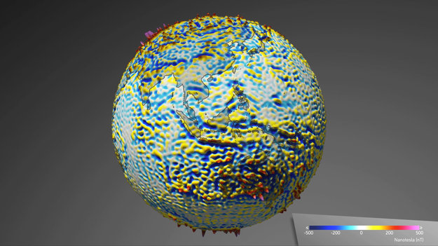
Thanks to the Swarm satellite trio, the most detailed magnetic map yet from space of Earth's rigid outer layer has been released
30 years of deforestation
21.3.2017 14:00 ESA Observing the Earth
While the world marks the International Day of Forests, satellites continue to monitor the long-term effects of human activities on our planet’s precious resources
HD GEO, s.r.o. hledá zeměměřiče pro Zlínský kraj
21.3.2017 13:05 Blogující geomatici - FAV ZČU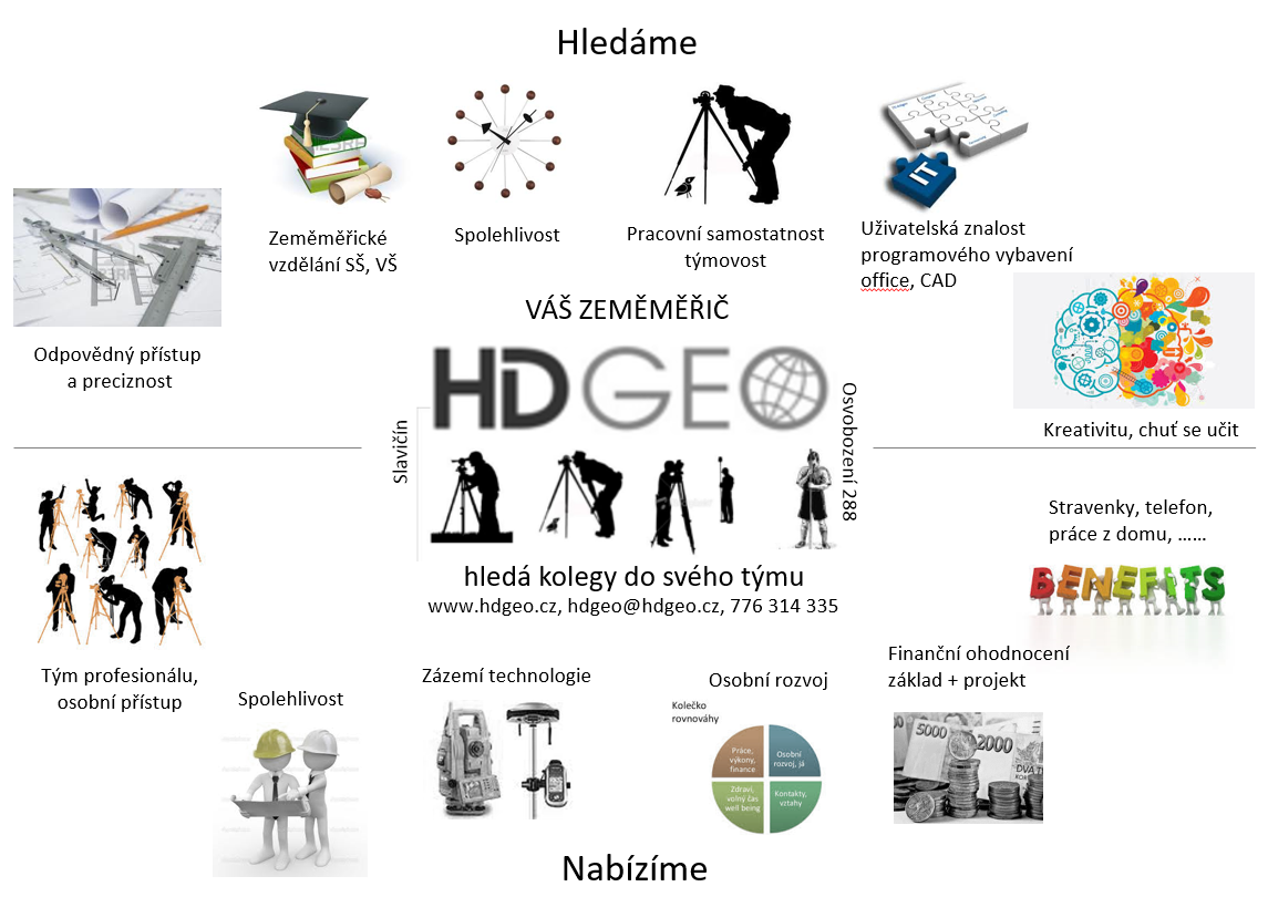
Lubomír Lazar získal certifikaci pro software FME
21.3.2017 11:27 GIS FórumLubomír Lazar získal certifikaci od společnosti Safe Software "FME Certified Professional".
- Znalosti – držitel certifikátu disponuje několikaletou zkušeností s prací v FME
- Odbornost – na základě získaných zkušeností je držitel certifikátu oprávněn odborného školení
- Současné povědomí – držitel certifikátu má povědomí o stávajících a aktuálních trendech v rámci FME
- Aktuální technologie – držitel certifikátu taktéž využívá nejaktuálnější verze FME
- Kapacita – držitel certifikátu má zkušenosti se zpracováním rozsáhlých a široce orientovaných projektů, jejich kvalitní provedení je podloženo pozitivními referencemi od zákazníků
- Originalita – držitel certifikátu se při realizaci projektů prokázal originalitou při řešení dílčích problémů
- Profesionální přístup – držitel se taktéž prokazuje svojí spolehlivostí a profesionálním přístupem ve vztahu se zákazníkem
Nejnovější trendy ve výzkumu Land Use/Land Cover byly prezentovány na konferenci v ESA [Katedra aplikované geoinformatiky a kartografie, byTopic]
21.3.2017 11:25 Katedra aplikované geoinformatiky a kartografie Přf UK Minulý týden 14.-16. 3. 2017 se konala ve středisku ESA/ESRIN v Římě významná mezinárodní konference prezentující nejnovější výzkumné a technologické trendy výzkumu Land Use/Land Cover pomocí dálkového průzkumu Země (DPZ).Referent KN – pracovník výpravny
21.3.2017 10:43 ČÚZK - předpisy a opatření Nově vyhlášená výběrová řízení na služební místa: Referent KN – pracovník výpravnyReferent KN – pracovník výpravny
21.3.2017 10:43 ČÚZK /Urady/Katastralni-urady/Katastralni-urady/Katastralni-urad-pro-hlavni-mesto-Prahu/O-uradu/Aktuality/Referent-KN-–-pracovnik-vypravnyPracovní pozice: Podpora obchodu
21.3.2017 10:19 TopGis Společnost TopGis, s.r.o. vypisuje výběrové řízení na pozici „Podpora obchodu“ na hlavní pracovní poměr jako zástup za mateřkou dovolenou. Pracovní náplň: Požadavky: Pracoviště: V případě Vašeho zájmu nám pošlete Váš strukturovaný životopis na emailovou adresu kariera@topgis.cz. Odpovědí na inzerát či zasláním Vašeho životopisu a případných dalších osobních materiálů do společnosti TopGis, s.r.o., dáváte souhlas keUnravelling Earth’s magnetic field
21.3.2017 10:00 ESA Observing the Earth
ESA’s Swarm satellites are seeing fine details in one of the most difficult layers of Earth’s magnetic field to unpick – as well as our planet’s magnetic history imprinted on Earth’s crust.
Odborný referent v oddělení aktualizace a dokumentace katastru nemovitostí Katastrálního pracoviště
21.3.2017 9:49 ČÚZK /Urady/Katastralni-urady/Katastralni-urady/Katastralni-urad-pro-Kralovehradecky-kraj/Uredni-deska/Oznameni-a-jina-uredni-sdeleni/Volna-mista/Odborny-referent-v-oddeleni-aktualizace-a-dokumentOdborný referent v oddělení aktualizace a dokumentace katastru nemovitostí Katastrálního pracoviště
21.3.2017 9:49 ČÚZK - volná místa Katastrální úřad pro Královéhradecký kraj, Katastrální pracoviště Náchod vypisuje výběrové řízení na místo Odborný referent v oddělení aktualizace a dokumentace katastru nemovitostí Katastrálního pracovištěOdborný referent v oddělení aktualizace a dokumentace katastru nemovitostí Katastrálního pracoviště
21.3.2017 9:49 ČÚZK - předpisy a opatření Katastrální úřad pro Královéhradecký kraj Katastrální pracoviště Náchodvypisuje výběrové řízení na místo
Odborný referent v oddělení aktualizace a dokumentace katastru nemovitostí Katastrálního pracoviště Náchod
Nabídka práce pro geodety v Praze
21.3.2017 8:41 GISportal.cz Společnost NAVITEL s.r.o. hledá do svého týmu nové kolegy na pozici geodet.Oznámení o vyhlášení výběrového řízení na služební místo odborný rada oddělení správy majetku státu, Krajský pozemkový úřad pro Plzeňský kraj
21.3.2017 0:00 Státní pozemkový úřad Ústřední ředitelka Státního pozemkového úřadu, jako služební orgán příslušný podle § 10 odst. 1 písm. f) zákona č. 234/2014 Sb., o státní službě (dále jen „zákon“), vyhlašuje výběrové řízení.Oznámení o vyhlášení výběrového řízení na služební místo odborný rada oddělení ostatních veřejných zakázek, odbor veřejných zakázek
21.3.2017 0:00 Státní pozemkový úřad Ústřední ředitelka Státního pozemkového úřadu, jako služební orgán příslušný podle § 10 odst. 1 písm. f) zákona č. 234/2014 Sb., o státní službě (dále jen „zákon“), vyhlašuje výběrové řízení.Oznámení o vyhlášení výběrového řízení na služební místo odborný rada, Pobočka Havlíčkův Brod
21.3.2017 0:00 Státní pozemkový úřad Ústřední ředitelka Státního pozemkového úřadu, jako služební orgán příslušný podle § 10 odst. 1 písm. f) zákona č. 234/2014 Sb., o státní službě (dále jen „zákon“), vyhlašuje výběrové řízení.Oznámení o vyhlášení výběrového řízení na služební místo vrchní referent / rada, Pobočka Domažlice
21.3.2017 0:00 Státní pozemkový úřad Ústřední ředitelka Státního pozemkového úřadu, jako služební orgán příslušný podle § 10 odst. 1 písm. f) zákona č. 234/2014 Sb., o státní službě (dále jen „zákon“), vyhlašuje výběrové řízení.Oznámení o vyhlášení výběrového řízení na služební místo vrchní referent / rada, Pobočka Jindřichův Hradec
21.3.2017 0:00 Státní pozemkový úřad Ústřední ředitelka Státního pozemkového úřadu, jako služební orgán příslušný podle § 10 odst. 1 písm. f) zákona č. 234/2014 Sb., o státní službě (dále jen „zákon“), vyhlašuje výběrové řízení.Oznámení o vyhlášení výběrového řízení na služební místo rada/odborný rada, oddělení převodu majetku státu, Krajský pozemkový úřad pro Plzeňský kraj
21.3.2017 0:00 Státní pozemkový úřad Ústřední ředitelka Státního pozemkového úřadu, jako služební orgán příslušný podle § 10 odst. 1 písm. f) zákona č. 234/2014 Sb., o státní službě (dále jen „zákon“), vyhlašuje výběrové řízení.Oznámení o vyhlášení výběrového řízení na služební místo vrchní referent / rada, oddělení převodu majetku státu, Krajský pozemkový úřad pro Plzeňský kraj
21.3.2017 0:00 Státní pozemkový úřad Ústřední ředitelka Státního pozemkového úřadu, jako služební orgán příslušný podle § 10 odst. 1 písm. f) zákona č. 234/2014 Sb., o státní službě (dále jen „zákon“), vyhlašuje výběrové řízení.Oznámení o vyhlášení výběrového řízení na služební místo vrchní referent / rada, Pobočka Plzeň
21.3.2017 0:00 Státní pozemkový úřad Ústřední ředitelka Státního pozemkového úřadu, jako služební orgán příslušný podle § 10 odst. 1 písm. f) zákona č. 234/2014 Sb., o státní službě (dále jen „zákon“), vyhlašuje výběrové řízení.Windows Server Administrátor – junior, oddělení administrace ICT a infrastruktury
21.3.2017 0:00 Státní pozemkový úřad Státní pozemkový úřad přijme zaměstnance na pozici windows Server Administrátor – junior, oddělení administrace ICT a infrastruktury.Vedoucí Pobočky Olomouc
21.3.2017 0:00 Státní pozemkový úřad Státní pozemkový úřad přijme zaměstnance na pozici vedoucí Pobočky Olomouc.Advancing Infrastructure
20.3.2017 21:04 Bentley SystemsPress Coverage
Coordinates
Read the articleAdvancing Infrastructure
20.3.2017 21:04 Bentley SystemsPress Coverage
Coordinates
Read the articleAdvancing Infrastructure
20.3.2017 21:04 Bentley SystemsPress Coverage
Coordinates
Read the articleAdvancing Infrastructure
20.3.2017 21:04 Bentley SystemsPress Coverage
Coordinates
Read the articleThe YII 2016 - Outstanding Structural Engineering Projects
20.3.2017 21:02 Bentley SystemsPress Coverage
Informed Infrastructure
Read the articleThe YII 2016 - Outstanding Structural Engineering Projects
20.3.2017 21:02 Bentley SystemsPress Coverage
Informed Infrastructure
Read the articleThe YII 2016 - Outstanding Structural Engineering Projects
20.3.2017 21:02 Bentley SystemsPress Coverage
Informed Infrastructure
Read the articleThe YII 2016 - Outstanding Structural Engineering Projects
20.3.2017 21:02 Bentley SystemsPress Coverage
Informed Infrastructure
Read the articleBlack & Veatch Receive Special Recognition for Span of Bentley Software Implementation
20.3.2017 21:00 Bentley SystemsPress Coverage
MicroStation Connections
Read the articleBlack & Veatch Receive Special Recognition for Span of Bentley Software Implementation
20.3.2017 21:00 Bentley SystemsPress Coverage
MicroStation Connections
Read the articleCapturing, Modelling, and Building the Reality
20.3.2017 20:38 Bentley SystemsPress Coverage
GIM International
Read the articleCapturing, Modelling, and Building the Reality
20.3.2017 20:38 Bentley SystemsPress Coverage
GIM International
Read the articleSelected Projects from Bentley's 2016 Be Inspired Awards
20.3.2017 20:34 Bentley SystemsPress Coverage
AECbytes
Read the articleIndustry voices speak to oil and gas projects future
20.3.2017 20:11 Bentley SystemsPress Coverage
Plant Engineering
Read the articleStrong "Year in Infrastructure" for BIM, China
20.3.2017 20:09 Bentley SystemsPress Coverage
BuiltWorlds
Read the articleBentley Systems: Inspiring Industries
20.3.2017 20:05 Bentley SystemsPress Coverage
Water and Wastewater Asia
Read the articleBentley Systems: Inspiring Industries
20.3.2017 20:05 Bentley SystemsPress Coverage
Water and Wastewater Asia
Read the articleBentley Systems: Inspiring Industries
20.3.2017 20:05 Bentley SystemsPress Coverage
Water and Wastewater Asia
Read the articleBentley Systems: Inspiring Industries
20.3.2017 20:05 Bentley SystemsPress Coverage
Water and Wastewater Asia
Read the articleBentley Systems: Inspiring Industries
20.3.2017 20:05 Bentley SystemsPress Coverage
Water and Wastewater Asia
Read the article18 Bentley Systems Users Win 2016 'Be Inspired Awards'
20.3.2017 20:02 Bentley SystemsPress Coverage
CECR
Read the article18 Bentley Systems Users Win 2016 'Be Inspired Awards'
20.3.2017 20:02 Bentley SystemsPress Coverage
CECR
Read the article18 Bentley Systems Users Win 2016 'Be Inspired Awards'
20.3.2017 20:02 Bentley SystemsPress Coverage
CECR
Read the article18 Bentley Systems Users Win 2016 'Be Inspired Awards'
20.3.2017 20:02 Bentley SystemsPress Coverage
CECR
Read the articleKnowing What's Underground with BIM and GIS
20.3.2017 19:59 Bentley SystemsPress Coverage
AEC Cafe
Read the articleColumbian Engineering Firm Designs First of Its Kind Automatic Parking System with Bentley STAAD.Pro
20.3.2017 19:56 Bentley SystemsPress Coverage
MicroStation Connections
Read the articleDanfoss awarded for innovation in asset performance
20.3.2017 19:07 Bentley SystemsPress Coverage
MRO Magazine, USA
Read the articleDeep Machine Learning – how smart solutions lower energy costs and boost safety
20.3.2017 19:04 Bentley SystemsPress Coverage
MRO Magazine
Read the articleKen Adamson: BIM Innovations, Advantages for Adoption, New Developments for 2017
20.3.2017 18:30 Bentley SystemsPress Coverage
Informed Infrastructure
Read the articleAiden Mercer and Cyndi Smith: Going Digital, Impacts of Reality Modeling, Government Uptake, and YII 2017 in Asia
20.3.2017 18:08 Bentley SystemsPress Coverage
Read the Article
Read the articleGrowing Benefits of Asset Management Software
20.3.2017 17:59 Bentley SystemsPress Coverage
Read the Article
Read the article"Reality Modeling" Arrives
20.3.2017 17:56 Bentley SystemsPress Coverage
Build Design + Construction
Read the articleKids compete to make the world a better place – and learn, too
20.3.2017 16:54 Bentley SystemsPress Coverage
Cronkite News
Read the articleSome Takeaways from Supplier Press Announcements at ARC Forum
20.3.2017 16:52 Bentley SystemsPress Coverage
ARC Advisory Group
Read the articleProtecting Ningbo
20.3.2017 16:40 Bentley SystemsPress Coverage
Civil Engineering Surveyor
Read the articleSiemens, Bentley to digitalise utilities
20.3.2017 16:35 Bentley SystemsPress Coverage
FM ME
Read the articleSiemens, Bentley to digitalise utilities
20.3.2017 16:35 Bentley SystemsPress Coverage
FM ME
Read the articleSiemens, Bentley to digitalise utilities
20.3.2017 16:35 Bentley SystemsPress Coverage
FM ME
Read the articleSiemens, Bentley to digitalise utilities
20.3.2017 16:35 Bentley SystemsPress Coverage
FM ME
Read the article20170320 - Novinka ve ve verzi 2.1.2 - VDP
20.3.2017 16:29 ČÚZK /Uvod/Produkty-a-sluzby/RUIAN/RUIAN-novinky/2016/Novinka-ve-ve-verzi-2-1-2-VDP20170320 - Novinka ve ve verzi 2.1.2 - VDP
20.3.2017 16:29 ČÚZK - předpisy a opatření Obsahem instalace nové verze ISÚI/VDP do produkčního prostředí, která proběhla ve dnech 17. - 18. 3. 2017, byla nová funkčnost ve VDP - Plošný výběr. Popis nové funkčnosti je uveden v dokumentu v sekci 8. Veřejný dálkový přístup - informace v dokumentu "Vyhledání prvků ve VDP prostřednictvím funkce Plošný výběr".Zveřejněno 20. 3. 2017
20170320 - Novinka ve ve verzi 2.1.2 - VDP
20.3.2017 16:29 ČÚZK - předpisy a opatření Obsahem instalace nové verze ISÚI/VDP do produkčního prostředí, která proběhla ve dnech 17. - 18. 3. 2017, byla nová funkčnost ve VDP - Plošný výběr. Popis nové funkčnosti je uveden v sekci 8. Veřejný dálkový přístup - informace v dokumentu "Vyhledání prvků ve VDP prostřednictvím funkce Plošný výběr".Zveřejněno 20. 3. 2017
20170320 - Novinka ve ve verzi 2.1.2 - VDP
20.3.2017 16:29 ČÚZK /Uvod/Produkty-a-sluzby/RUIAN/RUIAN-novinky/2017/Novinka-ve-ve-verzi-2-1-2-VDP20170320 - Novinka ve ve verzi 2.1.2 - VDP
20.3.2017 16:29 ČÚZK - předpisy a opatření Obsahem instalace nové verze ISÚI/VDP do produkčního prostředí, která proběhla ve dnech 17. - 18. 3. 2017, byla nová funkčnost ve VDP - Plošný výběr. Popis nové funkčnosti je uveden v sekci 8. Veřejný dálkový přístup - informace v dokumentu "Vyhledání prvků ve VDP prostřednictvím funkce Plošný výběr".Zveřejněno 20. 3. 2017
Novinka ve ve verzi 2.1.2 - VDP
20.3.2017 16:29 ČÚZK /Uvod/Produkty-a-sluzby/RUIAN/RUIAN-novinky/2017/Novinka-ve-ve-verzi-2-1-2-VDPNovinka ve ve verzi 2.1.2 - VDP
20.3.2017 16:29 ČÚZK - předpisy a opatření Obsahem instalace nové verze ISÚI/VDP do produkčního prostředí, která proběhla ve dnech 17. - 18. 3. 2017, byla nová funkčnost ve VDP - Plošný výběr. Popis nové funkčnosti je uveden v dokumentu v sekci 8. Veřejný dálkový přístup - informace v dokumentu "Vyhledání prvků ve VDP prostřednictvím funkce Plošný výběr".Zveřejněno 20. 3. 2017
MMB integrates ProjectWise with OpenPlant PID
20.3.2017 16:26 Bentley SystemsPress Coverage
Arab Water World
Read the articleMMB integrates ProjectWise with OpenPlant PID
20.3.2017 16:26 Bentley SystemsPress Coverage
Arab Water World
Read the articleMMB integrates ProjectWise with OpenPlant PID
20.3.2017 16:26 Bentley SystemsPress Coverage
Arab Water World
Read the articleMMB integrates ProjectWise with OpenPlant PID
20.3.2017 16:26 Bentley SystemsPress Coverage
Arab Water World
Read the articleSizing Up a Safe Solution
20.3.2017 16:24 Bentley SystemsPress Coverage
Construction Week Qatar
Read the articleSizing Up a Safe Solution
20.3.2017 16:24 Bentley SystemsPress Coverage
Construction Week Qatar
Read the articleSizing Up a Safe Solution
20.3.2017 16:24 Bentley SystemsPress Coverage
Construction Week Qatar
Read the articleSizing Up a Safe Solution
20.3.2017 16:24 Bentley SystemsPress Coverage
Construction Week Qatar
Read the articleTo the Arctic for CryoSat and beyond
20.3.2017 16:20 ESA Observing the Earth
After the relative quiet of the long dark winter months, the Arctic will be a tad busier over the coming weeks as numerous researchers descend on this harsh, yet fragile environment. Their aim is not to disturb its beauty, but to join forces in an all-out effort to measure ice on land and sea.
Reality Modeling for Utility Infrastructure
20.3.2017 16:11 Bentley SystemsPress Coverage
GEOConnexion
Read the articleZADCO uses SACS to reinstate ship-impacted wellhead platform
20.3.2017 16:08 Bentley SystemsPress Coverage
Offshore Magazine
Read the articleIntroducing Analytical Cloud Services – The Optioneering Center
20.3.2017 15:58 Bentley SystemsPress Coverage
AEC Cafe
Read the articleIf it’s March, it must be Munich
20.3.2017 14:07 European GNSS Agency
The Munich Satellite Navigation Summit is established as one of the most important dates in the global GNSS community’s calendar. This year the Summit’s 14th edition took place from 14-16 March with the theme ‘GNSS – is it time for backup?’ The opening session examined a range of topics around GNSS in today’s changing political and technical environment.
The Munich Summit’s opening event is always a grand affair that takes place in the impressive Allerheiligen-Hofkirche (Court Church of All Saints) within the Residenz München – the majestic palace of the Bavarian princes.
Following a welcome from the Summit’s hosts, the Bavarian government and the Universität der Bundeswehr München, the plenary brought together prominent speakers from the global GNSS community to give their views on the events of the past year and look to the future.
Big year for Galileo
Clearly the highlight of 2016 from a European perspective was the successful launch of six Galileo satellites and the declaration of Initial Services on 15 December 2016.
Pierre Delsaux from the European Commission said that with the launch of Initial Services “for the first time users can now navigate using Galileo signals.” With Galileo now operational, it was important to reinforce Europe’s presence on the international scene with such initiatives as the recent cooperation agreement with Japan, he said.
Johann-Dietrich Woerner, Director General of the European Space Agency (ESA), also highlighted the achievement of 18 Galileo satellites in orbit. “Today people say that Galileo is the ‘European GPS’, but in the future we should aim for GPS being the ‘American Galileo’,” he said. Galileo had showed its capability, including its robustness, in a challenging environment. But there was also a need to prepare for the future: initial work on the next generation of Galileo has been supported by ESA member states.
Agreeing, Hansjoerg Dittus for the German Aerospace Centre, DLR, highlighted the need to develop the next generation of EU GNSS by reinforcing research and development competence during the build-up for full Galileo operational capability in 2020, and to develop technology for future systems.
For the French government, David Comby emphasised the need for an operational view on the Galileo programme and the GSA’s key role in maximising the benefits of the systems for the EU and its citizens.
Galileo is a reality
“Market adoption of Galileo is a reality,” declared Carlo des Dorides, Executive Director of the GSA. “In 2017, 17 GNSS receiver chipset manufacturers representing 95 % of global supply are already Galileo-enabled.”
“The dual frequency capability provided by Galileo promises to improve horizontal accuracy by a factor of four – and this is confirmed by the manufacturers,” he continued. “Today Galileo is deploying in orbit more dual frequency satellites than GPS. This will pave the way forward for new applications such as autonomous driving.”
He also noted that three Galileo-enabled smartphones (from BQ, Sony and Huawei) were already on the market.
Outside Europe, Harold Martin of the National Coordination Office for Space-Based Positioning, Navigation, and Timing in Washington DC gave the US perspective reiterating that “GPS customers are important to us, no matter where they are.” He also reflected on the theme of the Summit saying that if “something is precious to you, you need backup too” and added that the USA is looking at developing technology-neutral options for GNSS backup systems.
From China, Dr Xiaochun Lu said that the Beidou programme would continue to work to integrate and promote interoperability between GNSS constellations emphasising that Beidou was “developed by China but open to the world”.
Changing environment, bright future
Next, a wide-ranging discussion covered many of the issues facing GNSS. The European speakers looked to focus on the bright future for Galileo, emphasising that its performance was exceeding expectations even in this initial stage.
Carlo des Dorides described the opportunities for the Galileo Commercial Service, “This service will deliver both high precision and authentication,” he said. “Market surveys show a clear need in a range of businesses, from high-precision agriculture through authentication of logistics to timing services.” He added that the number of customers is estimated at around 1 million users by 2027.
Giving an overview of Galileo services in terms of future markets and emerging applications, des Dorides noted the results from the GSA’s GNSS Market Survey Report, the latest version of which will be published soon, and highlighted major interest in two segments: location-based services and road. “These make up around 90 % of the market,” he said.
Other important segments include civil aviation where aircraft is being with equipped with SBAS-compatible receivers and the promise of the rail sector was underlined. “GNSS will be a game changer in rail,” he said. “GNSS demonstrates a clearly improved safety case, especially on rural lines, of which there are some 60 000 kilometres in Europe.” He expected to see operational solutions by 2020 in this sector.
Concluding the discussion, des Dorides looked forward to new innovative uses of location information. “We need to look at technology trends,” he said. “The Internet of Things (IoT) and big data all require input from GNSS. For example, IoT objects need to communicate between themselves and highly precise and available location information is key to achieving this.”
Media note: This feature can be republished without charge provided the European GNSS Agency (GSA) is acknowledged as the source at the top or the bottom of the story. You must request permission before you use any of the photographs on the site. If you republish, we would be grateful if you could link back to the GSA website (http://www.gsa.europa.eu).
Glitter helps to monitor ocean waves
20.3.2017 13:52 ESA Observing the Earth
The notion of glitter might appear as somewhat frivolous, but scientists are using Sun glitter in images from the Copernicus Sentinel-2 mission to map the motion of the sea surface.
Connecting Europe and Asia through GNSS
20.3.2017 10:46 European GNSS Agency
A new series of articles will highlight the important work being done across the Asian region, providing European businesses with an inside look at GNSS market opportunities in India, China, Taiwan, Korea, Japan and South East Asia.
Home to over 60 % of the world’s population, Asia is the world’s fastest growing economic region – and an increasingly important global navigation satellite systems (GNSS) market. In fact, as the region transforms itself into a knowledge-based economy, several countries are preparing to launch their very own GNSS constellations. At the same time, companies from across the region are inserting themselves at every point of the GNSS value chain, including the manufacturing of chipsets.
According to the most recent edition of the European GNSS Agency’s (GSA) GNSS Market Report, Asia is also the primary region for global market growth in terms of in-use GNSS devices. The region is forecasted to grow 11 % per year, from 1.7 billion devices in 2014 to 4.1 billion in 2023 – more than the EU and North America combined.
A stepping stone to Asia
Clearly, Asia is quickly positioning itself as a GNSS hotspot. As such, the GSA is dedicated to ensuring that European businesses are in a position to benefit from it. As part of this effort, the Agency is actively engaged in several Horizon 2020-funded projects geared towards supporting European interest within the Asian GNSS market.
One of these projects, GNSS.asia, is dedicated to developing and implementing GNSS industrial cooperation between European and Asia-Pacific GNSS industries, with a focus on the downstream market. The project maintains a team of GNSS and industry experts in its target countries of India, China, Taiwan, Korea, Japan and South East Asia that lend individual support to European companies. For each of these countries, the project offers specific market analysis, networking and speaking opportunities at Asian events, and overall support to companies interested in doing business in or with Asia. All of its services are free of charge to European companies.
Over the past five years, GNSS.asia has assisted dozens of European small and medium-sized enterprises (SMEs) from across the entire GNSS value chain in finding suppliers, clients, distributers and research partners. “For a specialised micro-SME such as ours, the GNSS.asia initiatives have been a unique opportunity for internationalisation,” says IGUASSU Software Systems CEO Petr Bares. IGUASSU, which designs and develops GNSS test beds and simulators, worked with GNSS.asia to successfully find distributors within a key Asian market – an especially difficult feat for a western company. “For innovative companies, GNSS.asia serves as a crucial interface to the Asian economy,” adds Bares.
Country profiles
To highlight the important work being done across the Asian region, the GSA is launching a new series of articles. Each article will focus on a specific country and provide an inside look at leading segments, opportunities and future trends. In the coming months, tune in to read:
- China and location-based services (LBS): With an explosive annual growth rate forecasted at 46 % up to 2020, the Chinese LBS market is a huge and relatively accessible market for European players. The gaming and marketing segments are the most promising for cooperating with Chinese partners, but companies like TomTom are also seeing success in its joint venture with AutoNavi for mapping applications. More so, a rapidly aging Chinese population is triggering a surge of healthcare apps that rely on GNSS data for personal health management.
- Taiwan: Taiwan has emerged as a world-leading GNSS receiver and chipset manufacturer. Taiwan based Mediatek, for example, is the world’s second largest mobile chipset manufacturer. In 2015, it saw its market share jump from 14 % to 19 %. As a result, it now threatens the dominance of the current market leader, US-based Qualcomm. Placing a strong focus on R&D, Taiwanese chipset manufacturers will play a significant role in the future evolution of GNSS mobile chipsets.
- Korea and vehicle telematics: Considering that Korea and the EU are amongst the largest car manufacturing regions in the world, there is immense potential for collaboration in the automotive telematics industry. The Korean commercial vehicle telematics market experienced a growth rate of 5 % over the last five years, as Hyundai and KIA increasingly turn to GNSS as an integral part of future information technology services (ITS). On top of this, the EU-South Korea Free Trade Agreement eliminated duties for most industrial goods, further enhancing the favourable business environment for European entities.
- India and Smart Cities: Launched in 2015 by the Indian government, the Smart Cities Mission for Urban Development aims to transform 100 Indian cities into sustainable, safe and citizen-friendly environments. With a budget of USD 15 billion, GNSS applications will play a pivotal role in realising this vision, providing solutions for improving energy efficiency, waste management and urban mobility. There is also an opportunity for European companies to leverage their rail know-how following the 2013 authorisation of direct foreign investment in India’s railways.
- Japan and LBS: The GPS-based augmentation system QZSS, set to become operational in 2018, will drive domestic demand in centimetre-class applications for receiver manufacturers, system integrators and application developers. An estimated 80 % of the economic effects created by QZSS are forecasted to take place in the car navigation, mobile terminals and value-added mobility application segments. Furthermore, the upcoming 2020 Tokyo Olympics will give precise positioning and timing solutions an added boost.
- South East Asia and natural disaster monitoring and surveying: In a region frequently hit by natural disasters, the governments of Indonesia and the Philippines have made the development of early warning systems for tsunamis, earthquakes and volcanic eruptions a priority. With its nascent GNSS industry, South East Asia is a particularly promising field for foreign providers of GNSS applications. This is especially true in the surveying market, as the density of the tropical rain forest canopies that cover much of the region favour satellite-based surveying techniques.
Without a doubt, the evolving Asian GNSS landscape represents a land of opportunity – even for smaller European players. Despite all of its challenges, as you will see in the forthcoming series of articles, overcoming any entry barriers is not an insurmountable task. And while these articles cannot alleviate the need for a significant investment in resources and time on the part of an aspiring business, they can improve the odds of success by providing an insider’s perspective into the opportunity-filled Asian GNSS market.
Media note: This feature can be republished without charge provided the European GNSS Agency (GSA) is acknowledged as the source at the top or the bottom of the story. You must request permission before you use any of the photographs on the site. If you republish, we would be grateful if you could link back to the GSA website (http://www.gsa.europa.eu).
Connecting Europe and Asia through GNSS
20.3.2017 10:46 European GNSS AgencyA new series of articles will highlight the important work being done across the Asian region, providing European businesses with an inside look at GNSS market opportunities in India, China, Taiwan, Korea, Japan and South East Asia.
Home to over 60 % of the world’s population, Asia is the world’s fastest growing economic region – and an increasingly important global navigation satellite systems (GNSS) market. In fact, as the region transforms itself into a knowledge-based economy, several countries are preparing to launch their very own GNSS constellations. At the same time, companies from across the region are inserting themselves at every point of the GNSS value chain, including the manufacturing of chipsets.
According to the most recent edition of the European GNSS Agency’s (GSA) GNSS Market Report, Asia is also the primary region for global market growth in terms of in-use GNSS devices. The region is forecasted to grow 11 % per year, from 1.7 billion devices in 2014 to 4.1 billion in 2023 – more than the EU and North America combined.
A stepping stone to Asia
Clearly, Asia is quickly positioning itself as a GNSS hotspot. As such, the GSA is dedicated to ensuring that European businesses are in a position to benefit from it. As part of this effort, the Agency is actively engaged in several Horizon 2020-funded projects geared towards supporting European interest within the Asian GNSS market.
One of these projects, GNSS.asia, is dedicated to developing and implementing GNSS industrial cooperation between European and Asia-Pacific GNSS industries, with a focus on the downstream market. The project maintains a team of GNSS and industry experts in its target countries of India, China, Taiwan, Korea, Japan and South East Asia that lend individual support to European companies. For each of these countries, the project offers specific market analysis, networking and speaking opportunities at Asian events, and overall support to companies interested in doing business in or with Asia. All of its services are free of charge to European companies.
Over the past five years, GNSS.asia has assisted dozens of European small and medium-sized enterprises (SMEs) from across the entire GNSS value chain in finding suppliers, clients, distributers and research partners. “For a specialised micro-SME such as ours, the GNSS.asia initiatives have been a unique opportunity for internationalisation,” says IGUASSU Software Systems CEO Petr Bares. IGUASSU, which designs and develops GNSS test beds and simulators, worked with GNSS.asia to successfully find distributors within a key Asian market – an especially difficult feat for a western company. “For innovative companies, GNSS.asia serves as a crucial interface to the Asian economy,” adds Bares.
Country profiles
To highlight the important work being done across the Asian region, the GSA is launching a new series of articles. Each article will focus on a specific country and provide an inside look at leading segments, opportunities and future trends. In the coming months, tune in to read:
- China and location-based services (LBS): With an explosive annual growth rate forecasted at 46 % up to 2020, the Chinese LBS market is a huge and relatively accessible market for European players. The gaming and marketing segments are the most promising for cooperating with Chinese partners, but companies like TomTom are also seeing success in its joint venture with AutoNavi for mapping applications. More so, a rapidly aging Chinese population is triggering a surge of healthcare apps that rely on GNSS data for personal health management.
- Taiwan: Taiwan has emerged as a world-leading GNSS receiver and chipset manufacturer. Taiwan based Mediatek, for example, is the world’s second largest mobile chipset manufacturer. In 2015, it saw its market share jump from 14 % to 19 %. As a result, it now threatens the dominance of the current market leader, US-based Qualcomm. Placing a strong focus on R&D, Taiwanese chipset manufacturers will play a significant role in the future evolution of GNSS mobile chipsets.
- Korea and vehicle telematics: Considering that Korea and the EU are amongst the largest car manufacturing regions in the world, there is immense potential for collaboration in the automotive telematics industry. The Korean commercial vehicle telematics market experienced a growth rate of 5 % over the last five years, as Hyundai and KIA increasingly turn to GNSS as an integral part of future information technology services (ITS). On top of this, the EU-South Korea Free Trade Agreement eliminated duties for most industrial goods, further enhancing the favourable business environment for European entities.
- India and Smart Cities: Launched in 2015 by the Indian government, the Smart Cities Mission for Urban Development aims to transform 100 Indian cities into sustainable, safe and citizen-friendly environments. With a budget of USD 15 billion, GNSS applications will play a pivotal role in realising this vision, providing solutions for improving energy efficiency, waste management and urban mobility. There is also an opportunity for European companies to leverage their rail know-how following the 2013 authorisation of direct foreign investment in India’s railways.
- Japan and LBS: The GPS-based augmentation system QZSS, set to become operational in 2018, will drive domestic demand in centimetre-class applications for receiver manufacturers, system integrators and application developers. An estimated 80 % of the economic effects created by QZSS are forecasted to take place in the car navigation, mobile terminals and value-added mobility application segments. Furthermore, the upcoming 2020 Tokyo Olympics will give precise positioning and timing solutions an added boost.
- South East Asia and natural disaster monitoring and surveying: In a region frequently hit by natural disasters, the governments of Indonesia and the Philippines have made the development of early warning systems for tsunamis, earthquakes and volcanic eruptions a priority. With its nascent GNSS industry, South East Asia is a particularly promising field for foreign providers of GNSS applications. This is especially true in the surveying market, as the density of the tropical rain forest canopies that cover much of the region favour satellite-based surveying techniques.
Without a doubt, the evolving Asian GNSS landscape represents a land of opportunity – even for smaller European players. Despite all of its challenges, as you will see in the forthcoming series of articles, overcoming any entry barriers is not an insurmountable task. And while these articles cannot alleviate the need for a significant investment in resources and time on the part of an aspiring business, they can improve the odds of success by providing an insider’s perspective into the opportunity-filled Asian GNSS market.
Media note: This feature can be republished without charge provided the European GNSS Agency (GSA) is acknowledged as the source at the top or the bottom of the story. You must request permission before you use any of the photographs on the site. If you republish, we would be grateful if you could link back to the GSA website (http://www.gsa.europa.eu).
Žádost o opatření výpisu z evidence rejstříku trestů
20.3.2017 10:03 Zeměměřický úřadŽádost o opatření výpisu z evidence rejstříku trestů
Žádost o opatření výpisu z evidence rejstříku trestů
20.3.2017 10:03 Zeměměřický úřadŽádost o opatření výpisu z evidence rejstříku trestů
Atmospheric pollution
20.3.2017 9:52 ESA Observing the Earth
This special edition of Space explores how atmospheric pollution is measured by satellites
Další dvě kosmické vycházky pro Thomase Pesqueta
20.3.2017 9:44 Český Kosmický PortálBěhem své mise na Mezinárodní kosmické stanici uskuteční kosmonaut ESA Thomas Pesquet další dva výstupy do otevřeného prostoru.
Další dvě kosmické vycházky pro Thomase Pesqueta
20.3.2017 9:44 Český Kosmický PortálBěhem své mise na Mezinárodní kosmické stanici uskuteční kosmonaut ESA Thomas Pesquet další dva výstupy do otevřeného prostoru.