


![]()

zprávy
zdroje zpráv:Právník katastru nemovitostí
2.9.2016 8:33 ČÚZK - předpisy a opatření Katastrální úřad pro hlavní město Prahu Katastrální pracoviště Prahavypisuje výběrové řízení na místo
Právník katastru nemovitostí
Právník katastru nemovitostí
2.9.2016 8:33 ČÚZK - volná místa Katastrální úřad pro hlavní město Prahu, Katastrální pracoviště Praha vypisuje výběrové řízení na místo Právník katastru nemovitostíSatlab Geosolutions introduces SLX-1 Multi-application CORS GNSS Receiver
2.9.2016 5:48 Satlab GeosolutionsAskim, Sweden – September 2, 2016 – Today the Swedish based Survey and GIS equipment maker; Satlab Geosolutions AB, announces its multi-purpose multi-frequency SLX-1 GNSS receiver.
The post Satlab Geosolutions introduces SLX-1 Multi-application CORS GNSS Receiver appeared first on Satlab – Global Satellite Positioning Solutions.
Satlab Geosolutions introduces SLX-1 Multi-application CORS GNSS Receiver
2.9.2016 5:48 Satlab GeosolutionsAskim, Sweden – September 2, 2016 – Today the Swedish based Survey and GIS equipment maker; Satlab Geosolutions AB, announces its multi-purpose multi-frequency SLX-1 GNSS receiver.
The post Satlab Geosolutions introduces SLX-1 Multi-application CORS GNSS Receiver appeared first on SatLab – Global Satellite Positioning Solutions.
Novela zákona 106/1999 Sb. o svobodném přístupu k informacím
2.9.2016 4:45 Zeměměřič má ukotvit do českého právního řádu otevřená data. Prola po drobných peripetiích Poslaneckou sněmovnou i Senátem a čeká na podpis prezidenta...INSPIRE datová sada pro téma Využití území - kraj Zlínský
2.9.2016 2:00 Cenia - Katalog metadat ČR - INSPIRE INSPIRE datová sada pro téma Využití území - kraj Zlínský, odvozená z ploch a koridorů zásad územního rozvoje Zlínského kraje, aktualizované 2012.Státní pozemkový úřad pořádá konferenci k pozemkovým úpravám
2.9.2016 0:00 Státní pozemkový úřad Praha, 1. září 2016 – Ve dnech 5. a 6. října 2016 se uskuteční XIX. Konference pozemkové úpravy. Tato tradiční konference letos proběhne pod názvem „Změny krajiny proti změnám klimatu" a při příležitosti 25. výročí zákona o pozemkových úpravách a pozemkových úřadech.ČSN 75 2106-1 Hrazení bystřin a strží
1.9.2016 16:04 Asociace poskytovatelů služeb v pozemkových úpravách Dnes nabývá účinnosti ČSN 75 2106-1 Hrazení bystřin a strží – Část 1: Obecně, kterou se nahrazuje ČSN 75 2106 z května 1998.20160901Odborný/vrchní referent oddělení dokumentace katastru nemovitostí-KP Praha-východ
1.9.2016 15:50 ČÚZK - předpisy a opatření Na úřední elektronické desce Katastrálního úřadu pro Středočeský kraj, v sekci "Oznámení a jiná úřední sdělení"bylo vystaveno "Oznámení o vyhlášení výběrového řízení na služební místo odborný/vrchní referent oddělení dokumentace katastru nemovitostí pro Katastrální pracoviště Praha-východ"20160901Odborný/vrchní referent oddělení dokumentace katastru nemovitostí-KP Praha-východ
1.9.2016 15:50 ČÚZK /Urady/Katastralni-urady/Katastralni-urady/Katastralni-urad-pro-Stredocesky-kraj/Katastralni-pracoviste/KP-Praha-vychod/O-uradu/Aktuality/20152509-Oznameni-na-reditele-PZ20160901Odborný/vrchní referent oddělení dokumentace katastru nemovitostí-KP Praha-východ
1.9.2016 15:45 ČÚZK /Urady/Katastralni-urady/Katastralni-urady/Katastralni-urad-pro-Stredocesky-kraj/O-uradu/Aktuality/20152509-Oznameni-na-reditele-TS,-PZ-a-PV-(10)20160901Odborný/vrchní referent oddělení dokumentace katastru nemovitostí-KP Praha-východ
1.9.2016 15:45 ČÚZK - předpisy a opatření V části "Úřední deska", v sekci "Oznámení a jiná úřední sdělení" bylo vystaveno "Oznámení o vyhlášení výběrového řízení na služební místo Odborný/vrchní referent oddělení dokumentace katastru nemovitostí pro Katastrální pracoviště Praha-východ"Odborný/vrchní referent oddělení dokumentace katastru nemovitostí (1)
1.9.2016 15:42 ČÚZK /Urady/Katastralni-urady/Katastralni-urady/Katastralni-urad-pro-Stredocesky-kraj/Uredni-deska/Oznameni-a-jina-uredni-sdeleni/Volna-mista/Odborny-vrchni-referent-oddeleni-dokumentace-k-(2)Odborný/vrchní referent oddělení dokumentace katastru nemovitostí (1)
1.9.2016 15:42 ČÚZK - volná místa Katastrální úřad pro Středočeský kraj, Katastrální pracoviště Praha-východ vypisuje výběrové řízení na místo Odborný/vrchní referent oddělení dokumentace katastru nemovitostí (1)Odborný/vrchní referent oddělení dokumentace katastru nemovitostí (1)
1.9.2016 15:42 ČÚZK - předpisy a opatření Katastrální úřad pro Středočeský kraj Katastrální pracoviště Praha-východvypisuje výběrové řízení na místo
Odborný/vrchní referent oddělení dokumentace katastru nemovitostí
Earth from Space
1.9.2016 14:00 ESA Observing the Earth
The ‘Earth from Space’ video programme is back! Join us Friday, 2 September, at 10:00 CEST and discover Argentina’s Upsala Glacier
Odborný rada - inspektor/ka
1.9.2016 13:55 ČÚZK - předpisy a opatření Zeměměřický a katastrální inspektorát v Prazevypisuje výběrové řízení na místo
Odborný rada - inspektor/ka
Odborný rada - inspektor/ka
1.9.2016 13:55 ČÚZK - volná místa Zeměměřický a katastrální inspektorát v Praze, vypisuje výběrové řízení na místo Odborný rada - inspektor/kaOdborný rada - inspektor/ka
1.9.2016 13:55 ČÚZK /Urady/Zememericke-a-katastralni-inspektoraty/Zememericke-a-katastralni-inspektoraty/Zememericky-a-katastralni-inspektorat-v-Praze/Uredni-deska/Oznameni-a-jina-uredni-sdeleni/Volna-mista/Inspektor-kaPostoupili jsme do krajského kola Firmy roku 2016
1.9.2016 11:39 HrdličkaV soutěži Vodafonu Firma roku se hodnotí finanční ukazatele firem i podnikatelský příběh. Scoring zahrnuje ukazatele rentability, likvidity, zadluženosti, aktivity, ziskovosti a produktivity firmy. Do krajských kol postupuje vždy 10 firem, které se umístily v hodnocení scoringu nejlépe. Pořadí krajských finalistů je pak určeno na základě celkového skóre a hodnocení poroty, která přihlíží zejména k nefinančním faktorům... View Article
The post Postoupili jsme do krajského kola Firmy roku 2016 appeared first on HRDLIČKA spol. s r.o. - komplexní služby v oblasti geodézie.
POSTOUPILI JSME DO KRAJSKÉHO KOLA FIRMY ROKU 2016
1.9.2016 11:39 HrdličkaV soutěži Vodafonu Firma roku se hodnotí finanční ukazatele firem i podnikatelský příběh. Scoring zahrnuje ukazatele rentability, likvidity, zadluženosti, aktivity, ziskovosti a produktivity firmy. Do krajských kol postupuje vždy 10 firem, které se umístily v hodnocení scoringu nejlépe. Pořadí krajských finalistů je pak určeno na základě celkového skóre a hodnocení poroty, která přihlíží zejména k nefinančním faktorům... View Article
The post POSTOUPILI JSME DO KRAJSKÉHO KOLA FIRMY ROKU 2016 appeared first on HRDLIČKA spol. s r.o. - komplexní služby v oblasti geodézie.
Postoupili jsme do krajského kola Firmy roku 2016
1.9.2016 11:39 HrdličkaV soutěži Vodafonu Firma roku se hodnotí finanční ukazatele firem i podnikatelský příběh. Scoring zahrnuje ukazatele rentability, likvidity, zadluženosti, aktivity, ziskovosti a produktivity firmy. Do krajských kol postupuje vždy 10 firem, které se umístily v hodnocení scoringu nejlépe. Pořadí krajských finalistů je pak určeno na základě celkového skóre a hodnocení poroty, která přihlíží zejména k nefinančním faktorům... View Article
The post Postoupili jsme do krajského kola Firmy roku 2016 appeared first on HRDLIČKA spol. s r.o. - komplexní služby v oblasti geodézie.
Carlson Tech Support is Here to Help
1.9.2016 9:26 Carlson Software Free technical support from Carlson has been the company standard since its beginnings. Carlson tech support team members are at the ready to assist you with technical problems and registration walk-throughs. They’re available by phone or email, and also create tutorials answering frequently asked questions in the Carlson Knowledge Base. More information and how to contact support can be […]Intro to EO: sign up today
1.9.2016 9:00 ESA Observing the Earth
Sign up for a free online course that provides an introduction to optical satellite Earth observation. The five-week Future Learn course begins on 12 September
20160901-VŘ Metodika KN - správa a vedení
1.9.2016 8:56 ČÚZK /Aktuality-resort/2016/20160901-VR-Metodika-KN-sprava-a-vedeni20160901-VŘ Metodika KN - správa a vedení
1.9.2016 8:56 ČÚZK /Aktuality-resort/20160901-VR-Metodika-KN-sprava-a-vedeni20160901-VŘ Metodika KN - správa a vedení
1.9.2016 8:56 ČÚZK - předpisy a opatření Oznámení o vyhlášení výběrového řízení na služební místo - Metodika KN - správa a vedení - zde.20160901-VŘ Metodika KN - správa a vedení
1.9.2016 8:56 ČÚZK - předpisy a opatření Oznámení o vyhlášení výběrového řízení na služební místo - Metodika KN - správa a vedení - zde.20160901-VŘ Analytik - programátor
1.9.2016 8:54 ČÚZK /Aktuality-resort/20160901-VR-Analytik-programator20160901-VŘ Analytik - programátor
1.9.2016 8:54 ČÚZK - předpisy a opatření Oznámení o vyhlášení výběrového řízení na služební místo - Analytik - programátor - zde.20160901-VŘ Analytik - programátor
1.9.2016 8:54 ČÚZK /Aktuality-resort/2016/20160901-VR-Analytik-programator20160901-VŘ Analytik - programátor
1.9.2016 8:54 ČÚZK - předpisy a opatření Oznámení o vyhlášení výběrového řízení na služební místo - Analytik - programátor - zde.Analytik - programátor
1.9.2016 8:51 ČÚZK - předpisy a opatření Český úřad zeměměřický a katastrálnívypisuje výběrové řízení na místo
Analytik - programátor
Analytik - programátor
1.9.2016 8:51 ČÚZK - volná místa Český úřad zeměměřický a katastrální, vypisuje výběrové řízení na místo Analytik - programátorAnalytik - programátor
1.9.2016 8:51 ČÚZK /Urady/Cesky-urad-zememericky-a-katastralni/Uredni-deska/Oznameni-a-jina-uredni-sdeleni/Volna-mista/Analytik-programator-(1)Analytik - programátor (1)
1.9.2016 8:51 ČÚZK - předpisy a opatření Český úřad zeměměřický a katastrálnívypisuje výběrové řízení na místo
Analytik - programátor
Analytik - programátor (1)
1.9.2016 8:51 ČÚZK /Urady/Cesky-urad-zememericky-a-katastralni/Uredni-deska/Oznameni-a-jina-uredni-sdeleni/Volna-mista/Analytik-programator-(1)Analytik - programátor (1)
1.9.2016 8:51 ČÚZK - volná místa Český úřad zeměměřický a katastrální, vypisuje výběrové řízení na místo Analytik - programátor (1)Metodika KN - správa a vedení
1.9.2016 8:50 ČÚZK - předpisy a opatření Český úřad zeměměřický a katastrálnívypisuje výběrové řízení na místo
Metodika KN - správa a vedení
Metodika KN - správa a vedení
1.9.2016 8:50 ČÚZK /Urady/Cesky-urad-zememericky-a-katastralni/Uredni-deska/Oznameni-a-jina-uredni-sdeleni/Volna-mista/Metodika-KN-sprava-a-vedeniMetodika KN - správa a vedení
1.9.2016 8:50 ČÚZK - volná místa Český úřad zeměměřický a katastrální, vypisuje výběrové řízení na místo Metodika KN - správa a vedeníRaketa Ariane 5 pro družice Galileo dorazila na evropský kosmodrom
1.9.2016 7:46 Český Kosmický PortálPrvní nosná raketa Ariane 5 upravená tak, aby mohla nést kvarteto družic Galileo, dorazila na evropský kosmodrom ve Francouzské Guayaně. Nyní ji čeká příprava na listopadový start.
Raketa Ariane 5 pro družice Galileo dorazila na evropský kosmodrom
1.9.2016 7:46 Český Kosmický PortálPrvní nosná raketa Ariane 5 upravená tak, aby mohla nést kvarteto družic Galileo, dorazila na evropský kosmodrom ve Francouzské Guayaně. Nyní ji čeká příprava na listopadový start.
Informační schůzka pro nové studenty 19. září 2016
1.9.2016 7:13 Katedra geografie UP Olomouc Výuka v zimním semestru začíná v pondělí 19. září 2016, kdy proběhne také oficiální přivítání s prezenčními bakalářskými studenty geografických oborů, a to na informační schůzce v čase 12.15–13.45 na učebně LP 2001 (v čase přednášky z Planetární geografie). Účast na této schůzce doporučujeme všem nově nastupujícím studentům, proběhne na ní seznámení s podobou a pravidly studia a bude zde také prostor na Vaše otázky.Některé obecnější otázky Vám zatím může zodpovědět příručka Kudy Kam – průvodce prváka po UP, kterou obdržíte při zápisu ke studiu nebo si ji můžete stáhnout v elektronické podobě (PDF 6 MB).
Prague Hacks 2016
1.9.2016 6:05 Zeměměřič Posledních 11 dní zbývá pro předběnou registraci na letoní praský hackathon. Letos to bude u doopravdy nad otevřenými daty - v praském katalogu je k dnenímu dni u 171 datových sad.INSPIRE téma Adresy (AD)
1.9.2016 2:00 Cenia - Katalog metadat ČR - INSPIRE Data odpovídají směrnici INSPIRE pro téma adresy (AD). Vychází především z projektu RÚIAN (Registr územní identifikace, adres a nemovitostí), který je součástí základních registrů České Republiky a obsahuje informace o územní identifikaci, adresách a nemovitostech. Data publikovaná v rámci INSPIRE obsahují pouze adresní místa a jejich komponenty, kterými jsou stát, obec, část obce, městský obvod v Praze (MOP), městký obvod/městská část (MO/MČ), ulice a pošta a to na území celé České Republiky. Obsahují rozvněž geometrii, která určuje definiční bod adresního místa. V datové sadě nění uvedeno 2,59%, t.j. 75221 adresních míst (k 29. 08. 2016), protože neobsahují definiční bod, podle kterého by je bylo možné prostorově určit. Více v zákoně č. 111/2009 Sb., o základních registrech a ve vyhlášce č. 359/2011 Sb., o základním registru územní identifikace, adres a nemovitostí v platných zněních a INSPIRE Data Specification on Addresses v 3.0.1 z 26.4.2010.INSPIRE téma Budovy (BU)
1.9.2016 2:00 Cenia - Katalog metadat ČR - INSPIRE Data odpovídají směrnici INSPIRE pro téma budovy (BU). Data pochází částečně z projektu RÚIAN (Registr územní identifikace, adres a nemovitostí), který je součástí základních registrů České Republiky a obsahuje informace o územní identifikaci, adresách a nemovitostech, a částečně z ISKN (Informační systém katastru nemovistostí). Zdrojem informací o budovách v ISKN je objekt Stavba, v RÚIAN je to Stavební objekt. Většina Staveb je zároveň Stavebními objekty, ale jsou případy, kdy tomu tak není. Kromě Budov datová sada obsahuje i části budov, které jsou pro potřeby INSPIRE vyjádřeny vchody z RÚIAN. Vchody obsahují informace o počtu podlaží, technickoekonomických atributech apod. Datová sada pokrývá celé území české republiky. V datové sadě není uvedeno 2,12%, t.j. 88904 budov (k 29. 08. 2016), protože neobsahují definiční bod ani polygon. Více v zákoně č. 111/2009 Sb., o základních registrech, ve vyhlášce č. 359/2011 Sb., o základním registru územní identifikace, adres a nemovitostí v platných zněních, v zákoně 256/2013 Sb., o katastru nemovitostí, v katastrální vyhlášce č. 357/2013 Sb. v platném znění a INSPIRE Data Specification on Buildings v 3.0 z 13.12.2013.INSPIRE téma Parcely (CP)
1.9.2016 2:00 Cenia - Katalog metadat ČR - INSPIRE Data odpovídají směrnici INSPIRE pro téma katastrální parcely (CP). Vychází z katastrální mapy, která je závazným státním mapovým dílem velkého měřítka, obsahuje body polohového bodového pole, polohopis a popis a může mít formu digitální mapy, analogové mapy nebo digitalizované mapy. Data publikovaná v rámci INSPIRE obsahují pouze katastrální území (pro celou Českou Republiku) a parcely a jejich hranice z území, kde je digitální mapa (k 29. 08. 2016 je to 85,15% území České republiky, t.j. 67 156,34km2). Více katastrální zákon 256/2013 Sb., katastrální vyhláška č.357/2013 Sb. v platném znění a INSPIRE Data Specification on Cadastral Parcels v 3.0.1.Oznámení o uzavření pobočky
1.9.2016 0:00 Státní pozemkový úřad Z důvodu rozsáhlých stavebních prací bude ve dnech 12. - 16. 9. 2016 uzavřena pobočka Česká Lípa (KPÚ pro Liberecký kraj).Copernicus Sentinel-1A satellite hit by space particle
31.8.2016 16:00 ESA Observing the Earth
ESA engineers have discovered that a solar panel on the Copernicus Sentinel-1A satellite was hit by a millimetre-size particle in orbit on 23 August. Thanks to onboard cameras, ground controllers were able to identify the affected area. So far, there has been no effect on the satellite’s routine operations.
Copernicus Sentinel-1A satellite hit by space particle
31.8.2016 16:00 ESA Observing the EarthESA engineers have discovered that a solar panel on the Copernicus Sentinel-1A satellite was hit by a millimetre-size particle in orbit on 23 August. Thanks to onboard cameras, ground controllers were able to identify the affected area. So far, there has been no effect on the satellite’s routine operations.
Soutě Společně otevíráme data
31.8.2016 15:08 Zeměměřič Fond Otakara Motejla vyhlauje ji čtvrtý ročník soutěe o nejlepí aplikaci nad otevřenými daty.Práce v Praze na částečný úvazek
31.8.2016 14:43 GISportal.cz Hledáte v Praze práci na částečný úvazek v IT? Zkuste pozici Business Analytik Junior.Odborný referent v oddělení aktualizace a dokumentace katastru nemovitostí Katastrálního pracoviště
31.8.2016 14:01 ČÚZK - volná místa Katastrální úřad pro Ústecký kraj, Katastrální pracoviště Chomutov vypisuje výběrové řízení na místo Odborný referent v oddělení aktualizace a dokumentace katastru nemovitostí Katastrálního pracovištěOdborný referent v oddělení aktualizace a dokumentace katastru nemovitostí Katastrálního pracoviště
31.8.2016 14:01 ČÚZK - předpisy a opatření Katastrální úřad pro Ústecký kraj Katastrální pracoviště Chomutovvypisuje výběrové řízení na místo
Odborný referent v oddělení aktualizace a dokumentace katastru nemovitostí Katastrálního pracoviště Chomutov na Katastrálním úřadu pro Ústecký kraj
20160831 - Výstava Neobvyklá zeměpisná jména
31.8.2016 13:06 ČÚZK /Urady/Zememericky-urad/O-uradu/Aktuality/20160831-Vystava-Neobvykla-zemepisna-jmena20160831 - Výstava Neobvyklá zeměpisná jména
31.8.2016 13:06 Zeměměřický úřad Výstava Neobvyklá zeměpisná jménaOd 15. srpna se koná výstava „Neobvyklá zeměpisná jména“ v budově zeměměřických a katastrálních úřadů - přepážková hala.
Další informace naleznete v pozvánce.
20160831 - Výstava Neobvyklá zeměpisná jména
31.8.2016 13:06 ČÚZK - předpisy a opatření Výstava Neobvyklá zeměpisná jménaOd 15. srpna se koná výstava „Neobvyklá zeměpisná jména“ v budově zeměměřických a katastrálních úřadů - přepážková hala.
Další informace naleznete v pozvánce.
GEPRO na YouTube
31.8.2016 10:08 Zeměměřič Gepro připravilo na You Tube sérii krátkých videí, ve kterých vás postupně seznámí se způsoby vyuití svých produktů a naučí vás ve nezbytné pro efektivní vyuití vaich dat. Videa jsou vhodná i pro úplné začátečníky ve světě geoinformačních technologií.Program konference GIS v plánování měst a regionů
31.8.2016 8:08 Zeměměřič Byl zveřejněný program 2. ročníku konference GIS v plánování měst a regionů.Družice Sentinel-1A systému GMES/Copernicus zasažena úlomkem kosmické tříště
31.8.2016 7:48 Český Kosmický PortálTechnici ESA objevili, že jeden z panelů slunečních baterií na družici Sentinel-1A byl 23. srpna zasažený částicí o velikosti přibližně jednoho milimetru. Díky palubním kamerám byli pracovníci řídicího střediska schopni identifikovat zasaženou oblast. Událost nemá známý vliv na rutinní operace družice.
Družice Sentinel-1A systému GMES/Copernicus zasažena úlomkem kosmické tříště
31.8.2016 7:48 Český Kosmický PortálTechnici ESA objevili, že jeden z panelů slunečních baterií na družici Sentinel-1A byl 23. srpna zasažený částicí o velikosti přibližně jednoho milimetru. Díky palubním kamerám byli pracovníci řídicího střediska schopni identifikovat zasaženou oblast. Událost nemá známý vliv na rutinní operace družice.
Instruktážní videa na YouTube
31.8.2016 7:06 GEPRONa YouTube jsme pro vás připravili sérii krátkých videí, ve kterých vás postupně seznámíme se způsoby využití našich produktů a naučíme vše nezbytné pro efektivní využití vašich dat.… >>
Instruktážní videa na You Tube
31.8.2016 7:06 GEPRONa You Tube jsme pro vás připravili sérii krátkých videí, ve kterých vás postupně seznámíme se způsoby využití našich produktů a naučíme vše nezbytné pro efektivní využití vašich dat.… >>
Soutěž Společně otevíráme data - nový ročník
31.8.2016 7:00 Česká asociace pro geoinformaceFond Otakara Motejla vyhlašuje již čtvrtý ročník soutěže o nejlepší aplikaci nad otevřenými daty Společně otevíráme data. Našim cílem je přispět k rozvoji a zlepšení služeb pro veřejnost a poukázat na společenský i podnikatelský potenciál otevřených dat. Soutěž se koná pod záštitou koordinátora digitální agendy ČR Tomáše Prouzy.
Soutěž je
GEPRO: Instruktážní videa na YouTube
31.8.2016 7:00 Česká asociace pro geoinformace Společnost GEPRO, kolektivní člen CAGI, představuje na YouTube sérii krátkých videí, ve kterých seznamuje diváky se způsoby využití svých produktů.Videa jsou vhodná i pro úplné začátečníky ve světě geoinformačních technologií.
Videa jsou rozdělena do čtyř témat: MISYS, PROLAND, Pasporty a Geoportál GEPRO. V každém z témat jsou k dispozici 3 ukázkové klipy
ČGS Podložní a povrchová geologie - OneGeology-Europe - anglická verze
31.8.2016 2:00 Cenia - Katalog metadat ČR - INSPIRE Webová mapová služba (WMS) zobrazující datovou sadu GeoCR500, která byla vytvořena pro účely projektu OneGeology-Europe. Aktualizovaná v rámci projektu EGDI v roce 2016.Galileo’s Ariane 5 arrives at Europe’s Spaceport
30.8.2016 17:38 ESA Navigation
The first Ariane 5 rocket modified to carry four Galileo satellites into orbit has arrived at Europe’s Spaceport in French Guiana for a November launch.
Galileo’s Ariane 5 arrives at Europe’s Spaceport
30.8.2016 17:38 ESA NavigationThe first Ariane 5 rocket modified to carry four Galileo satellites into orbit has arrived at Europe’s Spaceport in French Guiana for a November launch.
systemizované místo rozhodování o povolení vkladu (1)
30.8.2016 14:05 ČÚZK - volná místa Katastrální úřad pro Olomoucký kraj, Katastrální pracoviště Šumperk vypisuje výběrové řízení na místo systemizované místo rozhodování o povolení vkladu (1)systemizované místo rozhodování o povolení vkladu (1)
30.8.2016 14:05 ČÚZK /Urady/Katastralni-urady/Katastralni-urady/Katastralni-urad-pro-Olomoucky-kraj/Volna-mista/systemizovane-misto-rozhodovani-o-povoleni-vkl-(1)systemizované místo rozhodování o povolení vkladu (1)
30.8.2016 14:05 ČÚZK - předpisy a opatření Katastrální úřad pro Olomoucký kraj Katastrální pracoviště Šumperkvypisuje výběrové řízení na místo
systemizované místo rozhodování o povolení vkladu
The New BRx6 GNSS Receiver Just Released
30.8.2016 10:06 Carlson Software The all-new Carlson BRx6 is a multi-GNSS, multi-frequency smart antenna, just released by Carlson Software Inc. Each BRx6 contains a multi-constellation, multi-band 372-channel GNSS receiver, Athena© RTK technology and an integrated Atlas© L-band receiver. In addition, the BRx6 contains electronic sensors that measure tilt, direction (electronic compass) and acceleration, fully supporting SurvCE’s advanced features like […]Presentamos el Nuevo Receptor GNSS Carlson BRx6
30.8.2016 10:02 Carlson Software La Nueva Smart Antenna, el receptor multi-constelación, multi-frecuencia Carlson BRx6 Carlson es el más reciente lanzamiento de Carlson Software Inc. Cada BRx6 contiene un receptor multi-banda, multi-constelación de 372 canales, un receptor con tecnología RTK Athena© y un receptor de integrado de banda L Atlas©. El BRx6 contiene además sensores electrónicos que miden la inclinación, […]Podívejte se na technologické sekce z konference v San Diegu
30.8.2016 9:44 ARCDATAUživatelská konference v San Diegu je zdrojem nových informací a poznatků od specialistů Esri. Pokud jste se nemohli konference zúčastnit, nemusíte zoufat. Esri nyní zveřejnila 50 videí z technologických sekcí konference. Podívat se můžete na prezentace o webových technologiích, živých datech, rastrových datech, o prostorových analýzách a různých aplikacích.

Podívejte se na technologické sekce z konference v San Diegu
30.8.2016 9:44 ARCDATAUživatelská konference v San Diegu je zdrojem nových informací a poznatků od specialistů Esri. Pokud jste se nemohli konference zúčastnit, nemusíte zoufat. Esri nyní zveřejnila 50 videí z technologických sekcí konference. Podívat se můžete na prezentace o webových technologiích, živých datech, rastrových datech, o prostorových analýzách a různých aplikacích.
Sign up for the 2016 EGNOS Service Provision Workshop, scheduled for 27 – 28 September, in Warsaw
30.8.2016 9:12 European GNSS Agency
The EGNOS Service Provision Workshop, which serves as the annual meeting for EGNOS stakeholders, users and application developers, is scheduled for 27-28 September in Warsaw, Poland.
Organised by the ESSP and the European GNSS Agency (GSA), the event will include EGNOS service status, debates, showcases and success stories from partners currently using EGNOS in real applications. The 2016 workshop will include a dedicated sessions on aviation, maritime and land market segments.
This will be the opportunity to a state of play after the publication of the LPV 200 service last year, the first approach procedures published and actually flown, as well as a view on what is coming next.
A draft agenda is available here.
More information and early registration are available at egnos-workshop@essp-sas.eu.
Media note: This feature can be republished without charge provided the European GNSS Agency (GSA) is acknowledged as the source at the top or the bottom of the story. You must request permission before you use any of the photographs on the site. If you republish, we would be grateful if you could link back to the GSA website (http://www.gsa.europa.eu).
Sign up for the 2016 EGNOS Service Provision Workshop, scheduled for 27 – 28 September, in Warsaw
30.8.2016 9:12 European GNSS AgencyThe EGNOS Service Provision Workshop, which serves as the annual meeting for EGNOS stakeholders, users and application developers, is scheduled for 27-28 September in Warsaw, Poland.
Organised by the ESSP and the European GNSS Agency (GSA), the event will include EGNOS service status, debates, showcases and success stories from partners currently using EGNOS in real applications. The 2016 workshop will include a dedicated sessions on aviation, maritime and land market segments.
This will be the opportunity to a state of play after the publication of the LPV 200 service last year, the first approach procedures published and actually flown, as well as a view on what is coming next.
A draft agenda is available here.
More information and early registration are available at egnos-workshop@essp-sas.eu.
Media note: This feature can be republished without charge provided the European GNSS Agency (GSA) is acknowledged as the source at the top or the bottom of the story. You must request permission before you use any of the photographs on the site. If you republish, we would be grateful if you could link back to the GSA website (http://www.gsa.europa.eu).
Odborný rada - Oddělení právních vztahů k nemovitostem (1)
30.8.2016 8:01 ČÚZK /Urady/Katastralni-urady/Katastralni-urady/Katastralni-urad-pro-Karlovarsky-kraj/Uredni-deska/Oznameni-a-jina-uredni-sdeleni/Volna-mista/Odborny-rada-Oddeleni-pravnich-vztahu-k-nemovi-(2)Odborný rada - Oddělení právních vztahů k nemovitostem (1)
30.8.2016 8:01 ČÚZK - předpisy a opatření Katastrální úřad pro Karlovarský kraj Katastrální pracoviště Sokolovvypisuje výběrové řízení na místo
Odborný rada - Oddělení právních vztahů k nemovitostem
Odborný rada - Oddělení právních vztahů k nemovitostem (1)
30.8.2016 8:01 ČÚZK - volná místa Katastrální úřad pro Karlovarský kraj, Katastrální pracoviště Sokolov vypisuje výběrové řízení na místo Odborný rada - Oddělení právních vztahů k nemovitostem (1)Mise Sentinel-1 nabízí nový pohled na zemětřesení v Itálii
30.8.2016 7:49 Český Kosmický PortálVe středu 24. srpna zasáhlo střední Itálii zemětřesení, které si vyžádalo nejméně 290 životů a rozsáhlé materiální škody. Při zajišťování pomoci humanitárními organizacemi byly využity družicové snímky - a vědci už s jejich pomocí začali analyzovat pohyb zemského pokryvu.
Mise Sentinel-1 nabízí nový pohled na zemětřesení v Itálii
30.8.2016 7:49 Český Kosmický PortálVe středu 24. srpna zasáhlo střední Itálii zemětřesení, které si vyžádalo nejméně 290 životů a rozsáhlé materiální škody. Při zajišťování pomoci humanitárními organizacemi byly využity družicové snímky - a vědci už s jejich pomocí začali analyzovat pohyb zemského pokryvu.
KOKEŠ a PROLAND nově ve verzi 12.66
30.8.2016 7:05 GEPROZveřejnili jsme verzi 12.66 našich produktů KOKEŠ a PROLAND.
Stahovat ji můžete z obvyklého umístění na našem download serveru:
Podrobný výčet novinek naleznete v přehledech změn u jednotlivých produktů.… >>
Nový design aplikace CleverAssets
29.8.2016 17:05Naše aplikace prošla minulý týden redesignem. Ten přinesl nejen nový vzhled, ale i několik nových funkcí.

Obr. 1: Ukázka nového designu aplikace
Zapracovali jsme zejména na výstupech z aplikace. Kromě úpravy exportů seznamu smluv a parcel, kde je nyní možné volit z více variant, je nyní v Reportech a analýzách k dispozici sada několika nových výstupů.

Obr. 2: Reporty, analýzy
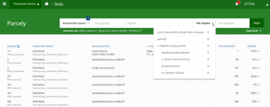
Asi nejzajímavější je část týkající se analýzy parcel. K dispozici jsou hned tři výstupy:
1. moje parcely v cizích půdních blocích
Zde je možné nalézt seznam všech mých parcel ležících v půdních blocích ostatních subjektů, včetně vyčíslení výměry dotčené půdními bloky. Toto oceníte zejména při směně užívání parcel.
2. moje parcely mimo moje půdní bloky
Tento výstup umožňuje nalézt seznam všech mých parcel ležících mimo půdní blok. Na tyto parcely např. neberete dotace, nebo na nich nehospodaříte a přitom platíte pachtovné.
3. cizí parcely v mých půdních blocích
Chcete nalézt parcely ve Vámi obhospodařovaných půdních blocích, které nemáte zasmluvněné? V aplikaci CleverAssets máte nově dvě možnosti, jak se k seznamu dostat. Kromě tohoto exportu můžete nově využít i přidaného filtru “pacht neuzavřen (užívání bez smlouvy)” v seznamu parcel. Tento výstup také využijete při směně užívání parcel.
Obr. 3: Cizí parcely v mých půdních blocích
Jeden z nově přidaných výstupů se svým pojetím vymyká těm dosavadním. V seznamu parcel při výběru parcel jen na několika LV lze vytvořit export přibližně podobný “Výpisu z katastru nemovitostí” obohacený o cenové a součtové údaje.
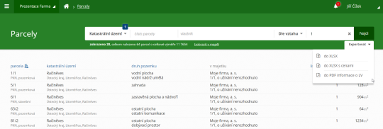
Obr. 4: Export “Výpisu z katastru nemovitostí”
Stránka Reporty a analýzy obsahuje užitečné statistické údaje, které obvykle požadují vedení firem. Jedná se o celkovou výměru obhospodařované půdy, výměru půdy ve vlastnictví, LPIS a výměru půdy propachtované a upozornění na různé nesrovnalosti.
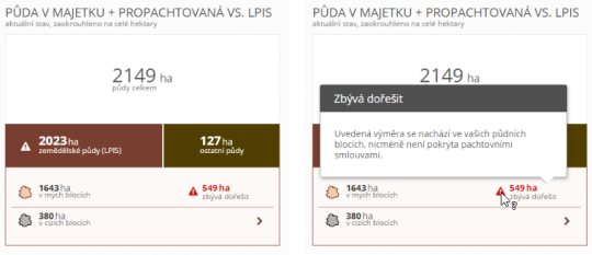
Obr. 5: Reporty a analýzy
Pevně věříme, že se Vám nová podoba aplikace líbí.
Jak aplikace funguje si můžete sami zdarma vyzkoušet v našem demu, ke kterému lze získat přístup na stránkách www.cleverassets.cz.
Sentinel-1 provides new insight into Italy’s earthquake
29.8.2016 16:52 ESA Observing the Earth
On 24 August, an earthquake struck central Italy, claiming at least 290 lives and causing widespread damage. Satellite images are being used to help emergency aid organisations, while scientists have begun to analyse ground movement.
Sentinel-1 provides new insight into Italy’s earthquake
29.8.2016 16:52 ESA Observing the EarthOn 24 August, an earthquake struck central Italy, claiming at least 290 lives and causing widespread damage. Satellite images are being used to help emergency aid organisations, while scientists have begun to analyse ground movement.
AssetWise APM Opens SAP Enterprise Asset Management Data to Integrity Engineers
29.8.2016 16:24 Bentley SystemsAssetWise APM helps integrity and reliability engineers working with SAP Enterprise Asset Management (EAM) to develop programs that support risk-based inspections (RBI) processes. With a view to the SAP Portal in real-time, inspectors and maintenance technicians are empowered with the information they need, when they need it – in the field. The SAP Portal view in AssetWise APM displays the following information:
- Functional location and equipment assets
- Functional location, equipment, and operations task lists
- SAP maintenance items
- Standard maintenance plans
With access to SAP EAM asset and work history, AssetWise APM users can navigate assets geospatially and get immediate feedback when condition readings are out of allowable tolerances. The asset health dashboard consolidates and analyzes all condition data from inspections and real-time monitoring devices, which facilitates more timely and accurate decisions on corrective actions. AssetWise APM’s certified integration with SAP EAM ensures that organizations using these systems together can drive a proactive process to manage asset reliability and integrity.
Other new capabilities in AssetWise APM include dashboards for strategy development analyses. These dashboards help identify the risk associated with asset failure and dynamic measurement points and accurately track and analyze data from locations that cannot be predetermined. This latter capability will be applied to subsea pipeline inspections conducted by remotely operated vehicles (ROVs), as well as to inspections on utility networks and railways (track).
The information collected in dynamic inspections is much more than the reading value and date collected. In the case of subsea inspections, it includes:
- Where is it – location, depth, length, area affected
- Conditions – water temperature
- Anodes, berms, debris, span, marine growth, burial information
Rob Churchman, senior director, product advancement, Bentley Systems, said, “Our users depend on AssetWise working seamlessly alongside SAP to ensure assets are safe and reliable. The SAP Portal view within AssetWise APM has been so successful that we have expanded the capabilities further to drive higher levels of asset performance.”
Download related images:
View Live SAP data
View live SAP data in AssetWise APM
Bentley offshore promo image
Bentley’s solutions span all offshore assets including fixed, floating, and subsea assets
Image Attribution: Image courtesy of Bentley Systems
20160829-VŘ Obecná právní agenda
29.8.2016 16:22 ČÚZK - předpisy a opatření Oznámení o vyhlášení výběrového řízení na služební místo - Obecná právní agenda - zde.20160829-VŘ Obecná právní agenda
29.8.2016 16:22 ČÚZK /Aktuality-resort/20160829-VR-Obecna-pravni-agenda20160829-VŘ Obecná právní agenda
29.8.2016 16:22 ČÚZK - předpisy a opatření Oznámení o vyhlášení výběrového řízení na služební místo - Obecná právní agenda - zde.20160829-VŘ Obecná právní agenda
29.8.2016 16:22 ČÚZK /Aktuality-resort/2016/20160829-VR-Obecna-pravni-agenda20160829-VŘ Analytik - programátor
29.8.2016 16:20 ČÚZK - předpisy a opatření Oznámení o vyhlášení výběrového řízení na služební místo - Analytik - programátor - zde.20160829-VŘ Analytik - programátor
29.8.2016 16:20 ČÚZK /Aktuality-resort/20160829-VR-Analytik-programator20160829-VŘ Analytik - programátor
29.8.2016 16:20 ČÚZK - předpisy a opatření Oznámení o vyhlášení výběrového řízení na služební místo - Analytik - programátor - zde.20160829-VŘ Analytik - programátor
29.8.2016 16:20 ČÚZK /Aktuality-resort/2016/20160829-VR-Analytik-programator20160829-VŘ Agenda veřejných zakázek a smluv O24
29.8.2016 16:19 ČÚZK - předpisy a opatření Oznámení o vyhlášení výběrového řízení na služební místo - Agenda veřejných zakázek a smluv odboru informatiky - zde.20162908-VŔ Agenda veřejných zakázek a smluv O24
29.8.2016 16:19 ČÚZK /Aktuality-resort/20162908-VR-Agenda-verejnych-zakazek-a-smluv-O2420160829-VŘ Agenda veřejných zakázek a smluv O24
29.8.2016 16:19 ČÚZK - předpisy a opatření Oznámení o vyhlášení výběrového řízení na služební místo - Agenda veřejných zakázek a smluv odboru informatiky - zde.20160829-VŘ Agenda veřejných zakázek a smluv O24
29.8.2016 16:19 ČÚZK /Aktuality-resort/20162908-VR-Agenda-verejnych-zakazek-a-smluv-O2420160829-VŘ Agenda veřejných zakázek a smluv O24
29.8.2016 16:19 ČÚZK /Aktuality-resort/2016/20162908-VR-Agenda-verejnych-zakazek-a-smluv-O24Agenda veřejných zakázek a smluv odboru informatiky
29.8.2016 15:59 ČÚZK - volná místa Český úřad zeměměřický a katastrální, vypisuje výběrové řízení na místo Agenda veřejných zakázek a smluv odboru informatikyAgenda veřejných zakázek a smluv odboru informatiky
29.8.2016 15:59 ČÚZK - předpisy a opatření Český úřad zeměměřický a katastrálnívypisuje výběrové řízení na místo
Agenda veřejných zakázek a smluv odboru informatiky
Agenda veřejných zakázek a smluv odboru informatiky
29.8.2016 15:59 ČÚZK /Urady/Cesky-urad-zememericky-a-katastralni/Uredni-deska/Oznameni-a-jina-uredni-sdeleni/Volna-mista/Agenda-verejnych-zakazek-a-smluv-odboru-informatikAnalytik - programátor
29.8.2016 15:58 ČÚZK - předpisy a opatření Český úřad zeměměřický a katastrálnívypisuje výběrové řízení na místo
Analytik - programátor
Analytik - programátor
29.8.2016 15:58 ČÚZK /Urady/Cesky-urad-zememericky-a-katastralni/Uredni-deska/Oznameni-a-jina-uredni-sdeleni/Volna-mista/Analytik-programatorAnalytik - programátor
29.8.2016 15:58 ČÚZK - volná místa Český úřad zeměměřický a katastrální, vypisuje výběrové řízení na místo Analytik - programátorObecná právní agenda (1)
29.8.2016 15:56 ČÚZK /Urady/Cesky-urad-zememericky-a-katastralni/Uredni-deska/Oznameni-a-jina-uredni-sdeleni/Volna-mista/Obecna-pravni-agenda-(1)Obecná právní agenda (1)
29.8.2016 15:56 ČÚZK - předpisy a opatření Český úřad zeměměřický a katastrálnívypisuje výběrové řízení na místo
Obecná právní agenda
Obecná právní agenda (1)
29.8.2016 15:56 ČÚZK - volná místa Český úřad zeměměřický a katastrální, vypisuje výběrové řízení na místo Obecná právní agenda (1)Seriál videoseminářů technické podpory – 2/2016
29.8.2016 14:00 ARCDATAV tomto díle videoseriálu technické podpory se dozvíte více o tzv. mapách s příběhem (Story Maps), tedy interaktivních responzivních webových aplikacích, které kombinují mapy, textový výklad a multimediální obsah. V druhé polovině videa se takovou mapu s příběhem naučíte i vytvářet.
Rada – řízení o údajích SGI, Katastrální pracoviště Plzeň-město
29.8.2016 12:46 ČÚZK - volná místa Katastrální úřad pro Plzeňský kraj, Katastrální pracoviště Plzeň-město vypisuje výběrové řízení na místo Rada – řízení o údajích SGI, Katastrální pracoviště Plzeň-městoRada – řízení o údajích SGI, Katastrální pracoviště Plzeň-město
29.8.2016 12:46 ČÚZK /Urady/Katastralni-urady/Katastralni-urady/Katastralni-urad-pro-Plzensky-kraj/Uredni-deska/Oznameni-a-jina-uredni-sdeleni/Volna-mista/Rada-–-rizeni-o-udajich-SGI,-Katastralni-pracovistRada – řízení o údajích SGI, Katastrální pracoviště Plzeň-město
29.8.2016 12:46 ČÚZK - předpisy a opatření Katastrální úřad pro Plzeňský kraj Katastrální pracoviště Plzeň-městovypisuje výběrové řízení na místo
Rada – řízení o údajích SGI, Katastrální pracoviště Plzeň-město